ni 43-101 technical report for el pinguico...
TRANSCRIPT

1
NI 43-101 TECHNICAL REPORT FOR
EL PINGUICO PROJECT
GUANAJUATO MINING DISTRICT, MEXICO
Guanajuato City, Guanajuato State
Mexico
Nearby Central coordinates
20°58' Latitude N, 101°13' longitude W
Prepared for
VANGOLD RESOURCES LTD.
1780-400 Burrard Street
Vancouver, British Columbia
V6C 3A6
Report By:
Carlos Cham Domínguez, C.P.G.
Consulting Geological Engineer
Effective Date: February 28, 2017

i
DATE AND SIGNATURE PAGE
AUTHOR CERTIFICATION
I, Carlos Cham Domínguez, am Certified Professional Geologist and work for FINDORE S.A.
DE C.V. located at Marco Antonio 100, col. Villa Magna, San Luis Potosi, S.L.P., Mexico
78210.
This certificate applies to the technical report entitled NI 43-101 Technical Report for El
Pinguico Project, Guanajuato Mining District, Mexico, with an effective date of February 28,
2017.
I am a Certified Professional Geologist in good standing with the American Institute of
Professional Geologists (AIPG) with registration number CPG-11760. I graduated with a
bachelor degree in Geology from the Universidad Autónoma de San Luis Potosí (Mexico) in
2003. I graduated with a MBA (finance) degree from the Universidad Tec Milenio (Mexico)
in 2012 and I have a diploma in Mining and Environment from the University Miguel de
Cervantes (Spain) in 2013.
I have practiced my profession continuously for 13 years and have been involved in: mineral
exploration and mine geology on gold and silver properties in Mexico.
As a result of my experience and qualifications, I am a Qualified Person as defined in
National Instrument 43-101.
I visited the El Pinguico Project between the 2nd and 5th of January, 2017.
I am responsible for the preparation of and take full responsibility for all sections of the
technical report.
I have not had prior involvement with the property that is the subject of this technical
report.
I am independent of the issuer, VANGOLD RESOURCES LTD. applying all the tests of Section
1.5 of National Instrument 43-101. I am also independent of Exploraciónes Mineras Del
Bajío S.A. de C.V., (EMDB), Ricardo Ramírez Zenteno and Maria Ascensión Canchola Guerra
and have no interest in the El Pinguico Project, Guanajuato Mining District, Mexico.

ii
I have read National Instrument 43-101 and Form 43-101 FI and the items for which I am
responsible in this report entitled, NI 43-101 Technical Report for El Pinguico Project,
Guanajuato Mining District, Mexico, with an effective date of February 28, 2017, has been
prepared in compliance with same.
As of the effective date of the technical report, to the best of my knowledge, information
and belief, the items of the technical report that I was responsible for contain all scientific
and technical information that is required to be disclosed to make the technical report not
misleading
Dated this 28 day of February, 2017 at San Luis Potosí, S.L.P., Mexico.
Signed at February 28, 2017
Signed and sealed
“Carlos Cham Domínguez”
Carlos Cham Domínguez, C.P.G.
Reg. No. CPG-11760

iii
TABLE OF CONTENTS
1.0 SUMMARY ....................................................................................................................... 1
1.1 LOCATION AND PROPERTY DESCRIPTION ..................................................................... 1
1.2 OWNERSHIP .................................................................................................................. 2
1.3 SURFACE RIGHTS, POWER, WATER, PERSONNEL, TAILINGS, PROCESSING PLANT AND
INFRASTRUCTURE ............................................................................................................... 2
1.4 HISTORY......................................................................................................................... 3
1.5 GEOLOGY ....................................................................................................................... 4
1.6 MINERALIZATION .......................................................................................................... 5
1.7 EXPLORATION ............................................................................................................... 5
1.8 INTERPRETATION AND CONCLUSIONS ......................................................................... 6
1.9 RECOMMENDATIONS ................................................................................................... 6
2.0 INTRODUCTION ............................................................................................................... 8
2.1 TERMS OF REFERENCE AND PURPOSE .......................................................................... 8
2.2 INFORMATION SOURCES .............................................................................................. 9
2.3 PARTICIPATION OF THE AUTHOR IN THE FIELD ............................................................ 9
3.0 RELIANCE IN OTHER EXPERTS ........................................................................................ 10
4.0 PROPERTY DESCRIPTION AND LOCATION ..................................................................... 11
4.1 PROPERTY AREA AND LOCATION ................................................................................ 12
4.2 LAND TENURE, LEGAL AGREEMENTS AND OTHER ASSETS ......................................... 12
5.0 ACCESIBILITY, CLIMATE, LOCAL RESOURCES, INFRASTRUCTURE AND PHYSIOGRAPHY 15
5.1 PHISIOGRAPHY, TOPOGRAPHY, ELEVATION, CLIMATE AND VEGETATION ................ 15
5.2 ACCESS AND PROXIMITY TO POPULATION CENTRES.................................................. 15
5.3 SURFACE RIGHTS, POWER, WATER, PERSONNEL, TAILINGS, PROCESSING PLANT AND
INFRASTRUCTURE ............................................................................................................. 15

iv
6.0 HISTORY ......................................................................................................................... 17
6.1 GUANAJUATO MINING DISTRICT ................................................................................ 17
6.2 EL PINGUICO-CARMEN MINE ...................................................................................... 18
Historical Estimation of the Underground Stockpile .................................................... 22
7.0 GEOLOGICAL SETTING AND MINERALIZATION.............................................................. 32
7.1 REGIONAL GEOLOGY ................................................................................................... 32
INTRUSIVE ROCKS .......................................................................................................... 33
7.3 STRUCTURE ................................................................................................................. 38
7.4 MINERALIZATION ........................................................................................................ 38
8.0 DEPOSIT TYPES .............................................................................................................. 41
9.0 EXPLORATION ................................................................................................................ 42
9.1 2017 SAMPLING PROGRAM OF THE UNDERGROUND STOCKPILE ............................ 42
9.2 Specific Gravity Analysis Results ................................................................................. 43
9.3 2017 Trench Sample Assay Results .......................................................................... 44
10.0 DRILLING ..................................................................................................................... 55
11.0 SAMPLE PREPARATION, ANALYSES AND SECURITY ................................................... 56
12.0 DATA VERIFICATION .................................................................................................. 57
13.0 MINERAL PROCESSING AND METALLURGICAL TESTING ............................................ 58
14.0 MINERAL RESOURCES ESTIMATES ............................................................................. 58
15.0 ADJACENT PROPERTIES .............................................................................................. 59
16.0 OTHER RELEVANT DATA AND INFORMATION ........................................................... 61
17.0 INTERPRETATION AND CONCLUSIONS ...................................................................... 62
18.0 RECOMMENDATIONS ................................................................................................ 65
19.0 REFERENCES ............................................................................................................... 67
20.0 APPENDICES............................................................................................................... 68
APPENDIX 1. CERTIFIED LABORATORY ANALYSES FOR THE SAMPLES COLLECTED IN THE
STOCKPILE BY THE AUTHOR .......................................................................................... 69

v
APPENDIX 2. FRAGMENTARY PROJECTION OF THE CARMEN MINE WITH ASSAYS
(LEVELS 7, 8, PINGUICO MINE COMPANY, 1909) ............................................................ 1
APPENDIX 3. PINGUICO MINE, PLAN OF 145 LEVEL WITH ASSAYS (HISTORICAL ARCHIVE
OF THE UNIVERSIDAD DE GUANAJUATO, 1907) ............................................................. 2
APPENDIX 4. LONGITUDINAL STOPE SHOWING VALUES BETWEEN LEVELS 7 AND 8
(HISTORICAL MAP OF PINGUICO MINES COMPANY, BETWEEN 1906 AND 1907). ......... 3
APPENDIX 5. .................................................................................................................... 4
APPENDIX 6. .................................................................................................................... 6
APPENDIX 7. .................................................................................................................... 7
APPENDIX 8. .................................................................................................................... 8

vi
Figures and Tables
Figure 1 El Pinguico Project Location Map ......................................................................... 11
Figure 2 Concession Map .................................................................................................... 14
Figure 3 Regional Geology ................................................................................................... 34
Figure 4 Stratigraphic Column ............................................................................................. 35
Figure 5 Local Geology ........................................................................................................ 37
Figure 6 Regional Structure and Major Vein Locations ...................................................... 40
Figure 7 Stockpile Longsection ............................................................................................ 49
Figure 8 Location of the 2017 Vangold Trenches on the Underground Stockpile .............. 50
Figure 9 Comparative Graph Showing Averaged Gold Results for Underground Stockpile Sampling by CRM(1959), SGM (2012) AND VANGOLD (2017) ............................................. 53
Figure 10 Comparative Graph Showing Averaged Silver Results for Underground Stockpile Sampling by CRM(1959), SGM (2012) AND VANGOLD (2017) ............................................. 53
Figure 11 Mineral Resource Estimate for Endeavor Silver’s El Cubo Mine, Effective date December 31, 2017 (Endeavor Silver, 2017) ........................................................................ 59
Figure 12 Mineral Reserve Estimate for Endeavor Silver’s El Cubo Mine, Effective date December 31, 2017 (Endeavor Silver, 2017) ........................................................................ 59
Figure 13 Adjacent Properties ............................................................................................ 60
Table 1 RESULTS OF MINERAL EXTRACTED FROM THE “DOS ESTRELLAS” STOPE ............... 19
Table 2 Historical Estimate for the "IN SITU” Vein Mineralization from BLOCKS 1, 2 and 3 (CRM 1959) (Shown in Mexican currency) ........................................................................... 21
Table 3 Assay Results of Unground Stockpile Samples from Blocks A, B and C, (CRM 1959) .............................................................................................................................................. 23
Table 4 Historical Estimate of the Underground Stockpile Including Blocks A, B AND C Estimated by CRM in 1959 (Shown in Mexican currency) ................................................... 24
Table 5 SAMPLE ASSAYS RESULTS FROM SGM TRENCH SAMPLES FROM EL PINGUICO UNDERGROUND STOCKPILE ................................................................................................. 26
Table 6 Assay Results that SGM did not Include in the Historical Estimate SGM (2012)..... 27
Table 7 Historical Estimate for the Underground Stockpile (SGM, 2012) ............................ 29
Table 8 Bulk Density Results (SGS 2012) (WITHOUT PRESENCE OF QP) .............................. 30
Table 9 SPECIFIC GRAVITY RESULTS PERFORMED BY SGS 2012 (WITHOUT PRESENCE OF QP) .............................................................................................................................................. 31
Table 10 SPECIFIC GRAVITY OF THE SAMPLES TAKEN BY THE AUTHOR FROM THE STOCKPILE AVERAGED TO 2.566 g/cm3 .................................................................................................. 43
Table 11 Comparison of Assay Results for the Underground Stockpile Trench Samples CRM (1959), SGM (2012) and Vangold (2017) .............................................................................. 44

vii
Table 12 Locations of the Vangold 2017 Trenches (Associated Figure 7 and Figure 8) ....... 47
Table 13 Assay Results for 2017 Trench Samples (Samples Collected by the Author) from El Pinguico Underground Stockpile .......................................................................................... 51
Table 14 Assay Results and Expected Value for Standard Reference Material and Blank Samples ................................................................................................................................. 56

1
EL PINGUICO MINE
GUANAJUATO, MX
NI 43-101 TECHNICAL REPORT
1.0 SUMMARY
VANGOLD RESOURCES LTD. (Vangold) has signed an asset acquisition agreement with
Exploraciónes Mineras Del Bajío S.A. de C.V., (EMDB) a private Mexican company, to acquire
100% interest in the El Pinguico property. The property consists of two contiguous mining
concessions covering 71 hectares, located approximately 5 km southeast of Guanajuato
city, in the state of Guanajuato, in central Mexico. These concessions encompass the
historic silver and gold El Pinguico-Carmen Mine. This Technical Report is being submitted
to support the information released in a press release on January 5, 2017 entitled “Vangold
Signs Agreement for 100% Interest In Historic El Pinguico Mine”.
The property has a historic mine with 2 access adits, one is called El Pinguico Adit and the
other called El Carmen Adit. The mine is not currently in operation and has not been in
operation since 1913. The main objective of the proposed exploration work is to gather all
available project data into a database, map the surface outcrops and underground openings
to better understand the geology and mineralization controls and assess the areas with
reported historical estimates for both the insitu vein material and the underground
stockpile.
The gold silver veins in the historical El Pinguico Mine have the same strike as the Veta
Madre (a locally prolific gold and silver vein in the region) and located approximately 4.5
km from the producing El Cubo Mine, a subsidiary of Endeavour Silver (TSX : EDR) and 2.5
km from Las Torres Mine of Fresnillo plc.
The property has excellent road access, communications, basic mining infrastructure and
proximity to beneficiation plants.
This report describes the results of the 2017 stockpile trench sampling, reports details of
the historical estimates and gives recommendations for further exploration work for the
project.
1.1 LOCATION AND PROPERTY DESCRIPTION
The Pinguico Project is located 5 kilometers southeast from Guanajuato city, the property
consists of two mining concessions (El Pinguico and 2ª Ampl. El Pinguico) for a total of 71
hectares.

2
EL PINGUICO MINE
GUANAJUATO, MX
NI 43-101 TECHNICAL REPORT
The property has an approximate altitude of 2200 meters above sea level, and the terrain
consists of gentle slopes and some abrupt terrain changes. Access is via the city of
Guanajuato by land transportation. The nearest community is Calderones and the nearest
city is Guanajuato (20 minutes).
1.2 OWNERSHIP
The mineral concessions were in the name of Ricardo Ramírez Zenteno (deceased) whose
wife Maria Ascensión Canchola Guerra inherited the titles. María Ascensión Canchola
Guerra ceded the rights to EMDB, which now has 100% of the title rights. The title transfer
documents are in the process of being registered under the approval of a public notary and
the public registry of mining. The author has relied on the opinion of a legal expert, who is
not a qualified person as defined by NI43-101, with respect to land tenure of the El Pinguico
concessions. Alberto M. Vázquez of the law firm VHG Servicios Legales, S.C., confirmed that
EMDB is the legal owner of the El Pinguico Title Documents and that they are not subject to
any prior claim by another party.
1.3 SURFACE RIGHTS, POWER, WATER, PERSONNEL, TAILINGS, PROCESSING
PLANT AND INFRASTRUCTURE
This project is within 7 km of a major city with a population exceeding 150,000 people.
There are no historic tailings ponds on the property.
The El Pinguico project has several mine workings and there are more than 10 other old
workings within the property and they have not been inspected by the author. The historic
mining of interest initially is the El Pinguico-Carmen Mine, which consists of 10 mining levels
according to the historic map. This mine is the most important on the property and has
several vertical shafts: the Humboldt shaft of 397 meters depth, the Pinguico shaft of 283
meters, the Fortuna shaft of 303 meters, the El Centro shaft of 200 meters and the
Carmencitas shaft of 61 meters. Access to the underground workings is by the El Carmen
adit on level 4, all other entrances are inaccessible. Inside the mine there is an underground
stockpile which was not extracted, and is located in the stope of the El Pinguico zone. There
is evidence of other underground mining activity on the property that needs to be inspected
and reviewed.

3
EL PINGUICO MINE
GUANAJUATO, MX
NI 43-101 TECHNICAL REPORT
On the surface there is a dump of approximately 90,000 m3 in an area of approximately
15,000 m2, the author recommends a program including rental of heavy machinery to
sample this material. There are remnants of old beneficiation plants. The property is close
to other working mines such as Las Torres mine of the company Fresnillo plc. (Figure 6).
1.4 HISTORY
Guanajuato is one of the oldest mining districts in North America with Spanish Colonial
mining dating back to 1520. It was between 1548 and 1554 when a silver deposit was
discovered in the area which led to the creation of Guanajuato as a population center.
The history of the El Carmen and El Pinguico Mines on the property began with the discovery
of gold silver mineralization and the first rich deposits began to be exploited in 1904 and
after a few years of operation, the mines closed due to the Mexican revolution in around
1913.
Inside the El Pinguico-Carmen mine, there is a large underground stockpile in the area of
the El Pinguico vein, which has been there since the mine was closed at the time of the
Mexican Revolution. Two Mexican government agencies have completed historical
estimates (CRM in 1959 and SGM in 2012), and Vangold will undertake work programs to
assess these historical estimates.
In 1959 the governmental organization “Consejo de Recursos Minerales” (CRM, the
Mexican Geological survey agency in 1959) completed a topographic survey of the stockpile
and an estimation of tonnes. Their work concluded there is 103,415 tonnes of stockpile
material and assigned an average grade of 2.72 g/t Au and 251 g/t Ag. The CRM also made
an estimation of insitu vein material and reported 4,921 tonnes with an average grade of
5.4 g/t Au and 424 g/t Ag (CRM 1959). The reports by CRM is not very detailed and there is
little information available regarding the key assumptions, parameters and methods used
for the estimates. The volume of the stockpile was estimated using a topographic survey of
the top of the pile and the volume of the workings from historical mine plans. The grade
was determined through trench sampling of top of the stockpile. Since only the top of the
stockpile could be accessed for sampling, these grades may not reflect the grades of
material throughout the stockpile and therefore should not be relied upon. The CRM
classified the historical estimates as probable reserves but due to the uncertainty
associated with the grade distributions through the stockpile the QP would not place them
in this category using current CIM guidelines for Probable Mineral Reserves. Vangold needs

4
EL PINGUICO MINE
GUANAJUATO, MX
NI 43-101 TECHNICAL REPORT
to verify the grade distribution in the entirety of the stockpile material and not just the top
1.5 meters to meet current guidelines for Mineral Reserves. The QP has not done sufficient
work to classify the historical estimate as current mineral resources or reserves and Vangold
is not treating the historical estimates as current mineral resources or reserves.
In 2012, EMDB asked the "Servicio Geológico Mexicano" (SGM, the Mexican Geological
Survey agency) to complete a estimation of grades and tonnage of the same underground
stockpile. SGM classified the historical estimate into “Certified Tonnes” and grade for the
top 5 m of the stockpile and only gave “Uncertified Tonnes” estimate for the remaining
stockpile material with no grade estimated. SGM reported finding 25,600 tonnes with an
average grade of 1.667 g/t Au and 143 g/t Ag, in their certified tonnage category and put
96,828 tonnes into their uncertified category and did not assign any grade to this material.
SGM determined the grade of the top 5m of the stockpile through trench sampling of the
material and estimated the tonnage by topographic survey and historical mine plans. SGM
did not have confidence that the grade obtained in their trench sampling reflected the grade
of the whole stockpile beyond a depth of 5m. SGM reported the tonnage of material below
the 5m threshold but did not assign any grade to the tonnes. None of the categories of
classification assigned by SGM comply with those set out in NI 43-101 or CIM guidelines.
The work that SGM completed to estimate the tonnage of the stockpile appear reasonable
and likely reflect the amount of material in the stopes. The grade distribution throughout
the whole of the stockpile needs to be verified before it can be applied to the whole of the
tonnes available and qualify for current classification standards. The QP has not done
sufficient work to classify the historical estimate as current mineral resources or reserves
and Vangold is not treating the historical estimates as current mineral resources or reserves.
The QP accepts these two historical estimates as reasonable estimates of the tonnage of
stockpile material available in the underground workings and recommends that Vangold
undertake a study to further assess the distributions of the grade throughout the whole of
the stockpile.
In 2017, the author completed a resampling program on the top of the stockpile and
returned similar grades for the trench samples as are reported by SGM (Section 9)
1.5 GEOLOGY
5
EL PINGUICO MINE
GUANAJUATO, MX
NI 43-101 TECHNICAL REPORT
The Guanajuato Mining District is located on the border between the Mesa Central
physiographic region and the Transmexican Volcanic Belt (Aranda-Gómez et al., 1989) of
Mexico. Within the property there are Mesozoic rocks with low grade metamorphism
where the schistosity is associated with folds with northeast dipping axes. In the mine area
there are mineralized normal faults of the Guanajuato Mining District.
On the property there exist different types and ages of lithologies: Esperanza Formation,
Red Conglomerate, La Luz Formation and a sequence of volcanic rocks (Loseros Formation,
Bufa Rhyolite tuff, Calderones Formation, Cedros andesite and Chichindaro Fm) (Carta
geológico Minera Aldama F14-C53 SGM, 2002). Some authors suggest that the El Pinguico
vein is a splay from the Veta Madre.
1.6 MINERALIZATION
The Guanajuato Mining District is mainly characterized by epithermal deposits associated
with continental Tertiary acid volcanism (e.g., Querol et al., 1991). On the El Pinguico
property, the most important historically productive vein has been the El Pinguico Vein,
which produced silver and gold.
The El Carmen-El Pinguico Vein is considered to be part of the top of the Veta Madre Vein
system, the main vein in the historic Guanajuato Silver District, and the depth extent is still
unknown. The mineralization in the Pinguico-Carmen mine, like those of the Guanajuato
camp in general, consist of a mixture of native gold and silver, polybasite, pyargyrite,
tetrahedrite, marcasite, sphalerite, galena, pyrite and chalcopyrite.
1.7 EXPLORATION
Vangold hired Findore S.A. DE C.V. (the author´s Geological Services Company in Mexico)
(Findore) to resample the underground stockpile to assess the gold and silver values
reported in the CRM (1959) and SGM (2012) reports. Vangold took these first steps to
initiate a due diligence review of the historical estimates.
The work included locating the same trenches sampled by SGM in 2012, removing slumped
material from the trenches and taking new samples in as close proximity to the historical
samples as possible. All the SGM trenches were easily located by the trench ID number
marked on the mine walls and Vangold’s work benefited from a worker assisting them who
had participated in the SGM sampling program. A total of 57 samples were obtained from
the trenches in the stockpile and sent for analysis.

6
EL PINGUICO MINE
GUANAJUATO, MX
NI 43-101 TECHNICAL REPORT
The results from the 2017 sampling program confirmed the grades found by SGM (2012) as
most of the individual sample results and the overall average grades are close in both gold
and silver values. The 2017 samples returned a slightly higher averaged value (1.75 g/t Au
and 183.58 g/t Ag) than SGM samples (1.662 g/t Au and 143 g/t Ag). The samples from the
CRM (1959) study, show much higher gold and silver values than SGM or the 2017 samples,
2.72 g/t Au and 251 g/t Ag. The higher results in the 58 year old study may be correct as the
stockpile may not have been so covered or diluted by falls of waste rock from the walls of
the mine as they appear to be in 2017. Vangold is pleased that the 2017 sampling program
found similar results in gold and silver grades to the historical work and they will undertake
further study work on the underground stockpile to review the tonnage estimations in the
historical reports and assess the distribution of the grade within the stockpile material.
1.8 INTERPRETATION AND CONCLUSIONS
Due to the 2017 stockpile sampling results obtained by VANGOLD and since there has been
no significant mineral extraction or exploration on the El Pinguico-Carmen Mine property
since it was closed in 1913, the author considers the El Pinguico project has potential for
hosting gold and silver mineralization and merits further exploration work. After Vangold
completes their initial surface investigations of the property, including mapping, they will
assess the potential for vein material in the mine and the parallel vein systems both along
strike and at depthDue to the results obtained by VANGOLD in 2017 from the stockpile
sampling (1.75 gr/ton Au and 183.58 gr/ton Ag) the author considers that the El Pinguico
project has potential which merits additional work. The new sampling has supported this
and due to the results of this exploration, the author recommends that VANGOLD continue
the exploration work on the project site.
1.9 RECOMMENDATIONS
In 2017, Vangold was able to confirm the historical grades used to support the historical
estimates. Now the company would like to continue this work of investigating the potential
of the underground stockpile but also wants to gather all available data on the project into
a project database and begin surface and underground investigations. There is a lot of
information to gather and synthesize before the next phase of exploration can be planned.
The mining on the project stopped in the early 1900s and there has been little exploration
completed on the project, specifically there are no records of any drilling being done. After
Vangold completes their initial surface investigations of the property, including mapping,

7
EL PINGUICO MINE
GUANAJUATO, MX
NI 43-101 TECHNICAL REPORT
they will assess the potential for vein material in the mine and the parallel vein systems
both along strike and at depth.
Specifically the author recommends
Phase 1: exploration work that includes a basic surface exploration program:
• Analysis and interpretation of satellite images: This is for the possible location of any
structures on the surface of the property, such veins or faults.
• Sampling the dump on the surface (rent a backhoe).
• Geochemical soil sampling: Make a geochemical grid of soil samples to locate
possible areas of interest.
• Surface geological survey: Detailed mapping of lithological units (1:2,000 scale),
alterations, structures and mineralization, all with their respective rock sampling.
• Data digitization: Integration of all the data taken in the field into a project database.
• Written Report to summarize the findings.
Total budget to complete Phase 1 program $107,000.00 CAD per 45 days and includes 1
Mexican QP, 1 Mexican senior geologist, 1 junior geologist, cost of the assays, equipment
rental, field assistants as required.
Mexican taxes and others (In Mexico there is a sales tax called “Impuesto al Valor Agregado”
I.V.A.) 16% of the Phase 1: $17,120.00 CAD.
Labour $35,000.00
Equipment Rental $32,000.00
Sample Analysis Costs $40,000.00
Phase 1 $107,000.00 CAD
I.V.A. Tax $ 17,120.00 CAD
TOTAL $ 124,120.00 CAD
Rounding this, we can have a general number for the costs:
Total budget to complete Phase 1 program $125,000.00 CAD

8
EL PINGUICO MINE
GUANAJUATO, MX
NI 43-101 TECHNICAL REPORT
2.0 INTRODUCTION
VANGOLD RESOURCES LTD. (Vangold) has signed an asset acquisition agreement with
Exploraciónes Mineras Del Bajío S.A. de C.V., (EMDB) a private Mexican company, to acquire
a 100% interest in the El Pinguico property. The property consists of two contiguous mining
concessions covering 71 hectares, located approximately 5 km southeast of Guanajuato
city, in the state of Guanajuato, Mexico. These concessions encompass the historic silver
and gold El Pinguico-Carmen Mine. This Technical Report is being submitted to support the
information released in a press release on January 5, 2017 entitled “Vangold Signs
Agreement for 100% Interest In Historic El Pinguico Mine”.
The property has a historic mine with 2 access adits, one is called El Pinguico Adit and the
other called El Carmen Adit. The mine is not currently in operation and has not been in
operation since 1913. The main objective of the proposed exploration work is to gather all
available project data into a database, map the surface outcrops and underground openings
to better understand the geology and mineralization controls and assess the areas with
reported historical estimates for both the in situ vein material and the underground
stockpile.
The property has excellent road access, communications, basic mining infrastructure and
proximity to beneficiation plants.
This report describes the results of the 2017 stockpile trench sampling, reports details of
the historical estimates and gives recommendations for further exploration work for the
project.
2.1 TERMS OF REFERENCE AND PURPOSE
Vangold commissioned the author of this independent NI 43-101 Technical Report to review
and summarize the historical mining work at the El Pinguico Project and recommend (if
appropriate) an initial exploration program to further understand the project geology and
complete further work to assess the areas of historical mining.
The author has been paid a fee for this work in accordance with normal professional
consulting practice and is acting as a Qualified Person as defined under National Instrument
43-101. The author conducted a personal inspection of the El Pinguico Property between
the 2nd and 5th of January, 2017.

9
EL PINGUICO MINE
GUANAJUATO, MX
NI 43-101 TECHNICAL REPORT
2.2 INFORMATION SOURCES
This report about the El Pinguico project is based on the following sources of
information:
• Publicly available technical reports, published by Mexican government agencies.
• Private technical documents made by people interested in the property.
• Press releases of VANGOLD RESOURCES.
• Discussions with the owners of the property, as well as with people who once
worked in El Pinguico mine.
• Maps from government agencies, previous owners and consultants.
All of the above information sources are listed in the Reference Section of this report. The
author has reviewed and analysed data provided by VANGOLD RESOURCES, previous
owners of the property and public information sources described above, and has drawn his
own conclusions.
2.3 PARTICIPATION OF THE AUTHOR IN THE FIELD
From the 2nd to the 5th of January 2017, the author performed a site visit to supervise and
ensure the quality of the work required. During this time, the author personally visited the
main El Pinguico Mine, supervised the 2017 underground trench sampling program.
Laboratory Certificates for the 2017 samples submitted to the assay laboratory are included
in Appendix 1.

10
EL PINGUICO MINE
GUANAJUATO, MX
NI 43-101 TECHNICAL REPORT
3.0RELIANCE IN OTHER EXPERTS
The author has relied on the opinion of a legal expert, who is not a qualified person as
defined by NI 43-101 with respect to land tenure of the El Pinguico concessions.
Alberto M. Vázquez of the law firm VHG Servicios Legales, S.C., confirmed that EMDB is the
legal owner of the El Pinguico Title Documents and that they are not subject to any prior
claim by another party. The Author relied heavily on this opinion to gain confidence in the
land tenure and issue the current report to Vangold. The land tenure for the El Pinguico
project with respect to the Mining Permits is included in Section 4 of this report and
specifically subsection 4-2 (page 10).
Alberto M. Vázquez issued a memo entitled, “TITLE OPINION, MINING CONCESSIONS, EL
PINGUICO PROJECT”, on the Date of February 28, 2017.

11
EL PINGUICO MINE
GUANAJUATO, MX
NI 43-101 TECHNICAL REPORT
4.0PROPERTY DESCRIPTION AND LOCATION
The property is located in Guanajuato Municipality of Guanajuato State in Mexico and is
centered near 20°58' Latitude N, 101°13' longitude W, at Universal Transverse Mercator
coordinates 269530 E, 2320054 N (WGS84 datum, Zone 14) and on Mexican government
1:50000 map sheet Aldama F14-C53 (Figure 1 and Figure 2).
Figure 1 El Pinguico Project Location Map

12
EL PINGUICO MINE
GUANAJUATO, MX
NI 43-101 TECHNICAL REPORT
4.1 PROPERTY AREA AND LOCATION
The El Pinguico project covers an area of 71 hectares. The Project is located 6.5 kilometers
to the southeast of the downtown of Guanajuato City and 1.8 kilometers to the southeast
of Calderones community in the State of Guanajuato, Mexico.
4.2 LAND TENURE, LEGAL AGREEMENTS AND OTHER ASSETS
The property consists of 2 mining claims (Figure 2). The first one is called EL PINGUICO, title
number T-166665, with an area of 48 hectares (expires on July 10, 2030 and has a mining
exploitation permit). The second claim is called 2nd AMPL. DE EL PINGUICO with title
number T-165491 and an area of 23.708 hectares (expires on October 29, 2029 and has a
mining exploitation permit). The current registered holder of the concessions is Maria
Ascensión Canchola Guerra.
The mineral concessions were under the name and control of Mr. Ricardo Ramírez Zenteno
(deceased) whose wife Mrs. Maria Ascensión Canchola Guerra inherited the titles. In 2012
Mrs. María Ascensión Canchola Guerra ceded the rights to EXPLORACIONES MINERAS DEL
BAJIO SA DE CV (EMBD) which currently holds and controls the 100% interest in the mining
claims. The mining claims have been certified by a notary public and now are in the process
of registration in the public registry of mining.
VanGold has signed an asset acquisition agreement with EMDB. Under the terms of the
agreement, Vangold will acquire 100% interest in the property by paying US$20,000 on
execution of the agreement, US$30,000 on receipt of TSXV approval, issue 5,000,000
common shares on closing, and make a final payment of US$50,000 on the date that is six
months after TSXV approval. Vangold has further granted EMDB royalties equal to (i) 4%
Net Smelter Return (NSR) and 15% Net Profit Interest (NPI) on minerals recovered from the
Stockpile; and (ii) 3% NSR (of which Vangold can repurchase one-third (ie. 1% NSR interest)
for US$1,000,000) and 5% NPI on all newly mined mineralization exclusive of the stockpile.
The agreement remains subject to a number of conditions, including the approval of the
TSX Venture Exchange. All securities issued will be subject to a four month hold period.
(VANGOLD NEWS RELEASE, Vancouver, B.C. / TheNewswire / January 5, 2017).
In Mexico, claims that are less than 1000 hectares do not require annual work requeriments.
The claims that cover the El Pinguico and Segunda Ampliacion de El Pinguico must report
any production of minerals from the claims and pay and annual fee of approximately
$750.00 CAD.
13
EL PINGUICO MINE
GUANAJUATO, MX
NI 43-101 TECHNICAL REPORT
Some of the local property owners within the concession have given permission for
exploration work to be carried out on their lands. Permission from the remaining land
owners will be acquired before the start of any drilling or surface trenching programs as this
first phase of work is completed.
The QP is not aware of any environmental liabilities located on the property or if
environmental studies have been completed on the project.
For the recommended work, the permission of the owners of the surface lands must be
obtained and until now, it has the permission of one owner, and this permit covers
approximately 60% of the surface lands of the claims of the El Pinguico project.
The author believes that there is no significant risk that may affect the access, title or right
or ability to perform the work.

14
EL PINGUICO MINE
GUANAJUATO, MX
NI 43-101 TECHNICAL REPORT
Figure 2 Concession Map

15
EL PINGUICO MINE
GUANAJUATO, MX
NI 43-101 TECHNICAL REPORT
5.0 ACCESIBILITY, CLIMATE, LOCAL RESOURCES,
INFRASTRUCTURE AND PHYSIOGRAPHY
5.1 PHISIOGRAPHY, TOPOGRAPHY, ELEVATION, CLIMATE AND VEGETATION
The State of Guanajuato is located in the Central Mesa and south of the Mexican Plateau.
The terrain consists of gentle slopes and some abrupt terrain changes. This central area with
respect to the country is strategic for its economic development, as it makes it a hub for
roads, railways and many kinds of economic activities.
Elevation on the property is around 2200 meters above sea level. The climate in the project
area is temperate with an average annual temperature of 18° C, with summer months
typically around 30° C and as low as 5° C in the winter. The rainy season is between the
months of June and September with annual precipitation typically 650 mm. The
classification of the regional climate would be warm-sub humid. Exploration and mining
operations can be carried out year round.
The vegetation in Guanajuato State is composed mainly of scrubland and grassland
((http://www.cuentame.inegi.org.mx, 11 January 2017) January 2017).
5.2 ACCESS AND PROXIMITY TO POPULATION CENTRES
The El Pinguico project is accessible from Guanajuato city via a road to Las Torres mine and
then from a road to the community of Calderones which is within the project area. The total
travel distance is 7 kilometers and travel time is about 20 minutes from Guanajuato. The
local access on the property is through an extensive network of unpaved roads.
Guanajuato city is one of the main cities of the central-north Mexico and also is the capital
of the state. It has services and typical tourist spots as expected in a touristic place.
5.3 SURFACE RIGHTS, POWER, WATER, PERSONNEL, TAILINGS, PROCESSING PLANT
AND INFRASTRUCTURE
This project is within 7 km of a major city with a population exceeding 150,000 people.
Vangold does not anticipate any problems with sourcing workers for the exploration phase
of the project. There are no historic tailings ponds on the property but there is a large waste

16
EL PINGUICO MINE
GUANAJUATO, MX
NI 43-101 TECHNICAL REPORT
rock dump from historic mining of approximately 90,000 m3 in an area of approximately
15,000 m2.
The El Pinguico project has several mine workings (more than 10 other old workings are
inside the property and not visited yet), but the main one is the El Pinguico-Carmen Mine,
which consists of 10 mining levels according to the historic map. This mine is the most
important on the property and has several vertical shafts: the Humboldt shaft of 397 meters
depth, the Pinguico shaft of 283 meters, the Fortuna shaft of 303 meters, the El Centro shaft
of 200 meters and the Carmencitas shaft of 61 meters. Currently this mine can only be
accessed by the El Carmen adit (level 4), all other entrances are inaccessible. Inside this
mine there is an underground stockpile which was never extracted, and is in the stope of
the El Pinguico zone. In the property there are other mine workings, some of them in veins
and with about 200 meters of development. On the surface there is a dump of
approximately 90,000 m3 in an area of approximately 15,000 m2, it is recommended to rent
heavy machinery to sample this material. There are also remnants of old beneficiation
plants. The property is close to other working mines such as Las Torres mine of the company
Fresnillo plc. (Figure 13).
The author’s initial due diligence work indicates that the property interest is subject only to
normal environmental regulations and liabilities as stipulated under the laws of Mexico and
the sufficiency of rights for exploration and mining operations on the property is subject
only to normal procedures and permits under the laws of Mexico. However the author
recommends that Vangold verify these operating parameters with their legal experts.
17
EL PINGUICO MINE
GUANAJUATO, MX
NI 43-101 TECHNICAL REPORT
6.0 HISTORY
6.1 GUANAJUATO MINING DISTRICT
The mining history of Guanajuato dates back to the sixteenth century, when the Spanish
conquerors started mineral exploration in the region in 1520. Between 1548 and 1554 silver
was discovered in the area of the San Bernabé and Rayas veins. This discovery led to the
settling of people in the area and the city of Guanajuato as a population center. Guanajuato
was one of the premier mining districts of Nueva España (New Spain) at this time.
In 1548 the first silver vein, San Bernabé (La Luz), was discovered by a local mule driver. In
these early years the silver ore was hand mined and transported by mule to Zacatecas to be
milled.
In 1558 the first mine shafts were sunk at Rayas and Mellado mines, which led to the
discovery of the famous Veta Madre Vein of Guanajuato. Today this vein runs along the hills
that border the glen of Guanajuato in the north and northwest, marked by mines and shafts
along its way. This discovery triggered an exploration rush that saw the discovery of the
Valenciana, Tepeyac, Mellado, Cata and Sirena silver occurrences.
In 1771 large inventories of silver sulphides, mixed with ruby silver and native silver were
discovered at Valenciana and the Valenciana Mine was estimated to be producing one-third
of the world’s silver.
During the period of 1760 to 1810, the Guanajuato mines accounted for 30% of the entire
Mexican production and 20% of the entire world’s output of silver. The Production stopped
as the result of the War of Independence from Spain in the year 1810, but in 1868 the
Valenciana mine was reopened by British investment capital. The principal or “mother vein
has yielded the sum of one billion dollars as indicated by the mint and government records.
The Valenciana mine proved to be the regions greatest silver producer with workings down
to 2,400 feet and producing over $300 million dollars of silver or approximately 60 million
British pounds”.
The Mexican Revolution occurred between 1910 and 1920 and all mining was stopped or
slowed during this time.

18
EL PINGUICO MINE
GUANAJUATO, MX
NI 43-101 TECHNICAL REPORT
6.2 EL PINGUICO-CARMEN MINE
The mining history of the El Carmen and El Pinguico Mines are intimately related. Initially
these mines belonged to different owners and their major mining works include: the
Humboldt shaft, Fortuna shaft, El Centro shaft, Carmencitas shaft and Pinguico shaft. All the
shafts were started in waste and were sunk to conduct underground exploration and mining
of the mineral deposits within the Carmen-Pinguico Fault system. This early work is thought
to have commenced around 1890.
The first rich deposits on the property began to be exploited in 1904, a year after the former
owner of the El Pinguico mine, Mr. Amado Delgado, transferred the mine to The Guanajuato
Development Company, directed by Mr. C.W. Bryant and renamed it The Pinguico Mining
and Milling Company. The mine was in production from the late 1800's to 1913 and
produced over 200,000 ounces of gold equivalent during this time (EMBSA, Proyecto El
Pingüico, 2014). A metallurgical plant was installed for the concentration and cyanidation
systems with a capacity of 250 tons per day (report with Unknown signature, 1945). This
plant no longer exists and was operated until the year 1913 when the owners left the region
due to armed conflicts.
Between 1932 and 1933, the engineer Luis Frausto carried out feasibility studies to exploit
headings and stopes at the El Carmen and El Pinguico Mines. According to his calculations,
an inventory of 75,000 tons of mineralization was estimated with grades (in average)
between of 300 to 400 gr/t Ag and 4 to 5 gr/t of Au, in addition to some mineral shoots
below level 8 (Meave, 1959). This is a historical estimate and may not be representative of
current mineral resources or reserves. The results of this study are presented in this report
to indicate the whole of the historical work completed on the project.
In 1944 Mr. Fernando Cueto Fernández reactivated the El Carmen-El Pinguico Mines briefly
but was not successful. In that same year, and early 1945, contractor Tomas Colmenero
tried to mine the "Dos Estrellas" stope, but the vein was very hard and the extraction
difficult. Mr. Tomas Colmenero extracted some mineralized material from the “Dos
Estrellas” stope and the resulting samples returned obtained the following results (report
with Unknown signature, 1945):

19
EL PINGUICO MINE
GUANAJUATO, MX
NI 43-101 TECHNICAL REPORT
Table 1 RESULTS OF MINERAL EXTRACTED FROM THE “DOS ESTRELLAS” STOPE
1959 CRM Historical Estimate Study of the El Pinguico Mine Area
In 1959 the governmental organization “Consejo de Recursos Minerales” (CRM, the
Mexican Geological survey agency in 1959) wrote a report titled “Geological Survey of the
Area El Pinguico”, where it reported “reserves” of an underground stockpile and a resource
estimation of “in situ” mineralization from the El Pinguico vein (see appendix 5).
Vangold is treating the resources and reserves from the CRM report as historical estimates.
The QP has not done sufficient work to classify the historical estimates as current mineral
resources or reserves and Vangold is not treating the historical estimates as current.
Vangold will undertake future work to assess the potential in these areas.
Historical Estimation of Insitu Veins
The historical estimate was built using polygonal method, based on 160 channel samples
taken in situ (see appendix 5, only shows places of interest). There is insufficient
information available on the methodology used in the estimate to form an opinion as to the
quality of the estimate.
DOS ESTRELLAS STOPE
The “Dos Estrellas stope”, is located northwest of the Pinguico shaft and is an area worked
by Pinguico Mines Company. The CRM made a long section map, showing elevated gold and
20
EL PINGUICO MINE
GUANAJUATO, MX
NI 43-101 TECHNICAL REPORT
silver values and appeared to demonstrate linear continuity of these values (Appendix 5).
The CRM took 17 channel samples from the Dos Estrellas stope and reported average vein
width = 1.52 m, 1.8 g/t Au, and 91 g/t Ag. In another area of this same stope, they report:
vein width = 0.8 m, 6.0 g/t Au, 733 g/t Ag.
CARSON STOPE
The Carson stope is located 50 m further north and in the same orientation of Dos Estrellas
stope and consists of a series of small mine workings, where the CRM found gold and silver
mineralization. The average of 11 samples taken in different parts of the workings gave the
following values: width of the vein = 1.05 m, 5.7 g/t Au, 457 g/t Ag.

21
EL PINGUICO MINE
GUANAJUATO, MX
NI 43-101 TECHNICAL REPORT
EL CARMEN ADIT
The CRM took 12 samples of muck pile the El Carmen adit, which gave averages of 1.0 g/t
Au and 128 g/t Ag.
Table 2 Historical Estimate for the "IN SITU” Vein Mineralization from BLOCKS 1, 2 and 3 (CRM 1959) (Shown in Mexican currency)
The in situ historical sampling data obtained by the CRM in 1959 appear reasonable to the
author, because they are similar to others in historical maps, although more work needs to
be done to verify this..
CRM reports a historical estimate of 4921 tonnes with grades of 5.4 g/t Au and 424 g/t Ag.
Table 5 is from the CRM report and show the classification applied to be probable reserves but
the author considers them to be a historical estimation and has limited information with
which to form an opinion on classification.
The reports by CRM is not very detailed and there is little information available
regarding the key assumptions, parameters and methods used for the estimates. CRM
estimated the tonnages of the insutu veins using polygonal blocks but did not report the
ranges of confidence for the blocks. The grades used in the estimate were obtained through
channel sampling in stopes of the vein material. To assess the potential of the insitu vein
material, Vangold should resample the areas outlined in the historical estimates area and
plan a drill program to test the vein material beyond the underground workings. The CRM
classified the historical estimates as probable reserves but due to the uncertainty
associated with the grade distributions beyond the vein exposures underground, the author
would not place them in this category using current CIM guidelines for Probable Mineral
Reserves. The author has not done sufficient work to classify the historical estimate as
22
EL PINGUICO MINE
GUANAJUATO, MX
NI 43-101 TECHNICAL REPORT
current mineral resources or reserves and Vangold is not treating the historical estimates
as current mineral resources or reserves. Vangold will undertake future work to assess the
potential in these areas.
Historical Estimation of the Underground Stockpile
An underground stockpile of broken mineralization is located in the northwest part of the
mine and partially occupies the block from level 4 to 7. This stockpile extends for 300 meters
longitudinally; unfortunately a part of this material is half covered by falls of the waste rock
that hosts the Pinguico vein (Figure 7).
CRM only considered material up to level 7 of the mine in the stockpile inventory but the
report mentions the possibility of additional material continuing in levels 8 and 9.
The CRM dug 20 trenches along the top of the stockpile to sample it. The averaged results
of all their samples is 3.2 g/t Au and 288 g/t Ag (4).

23
EL PINGUICO MINE
GUANAJUATO, MX
NI 43-101 TECHNICAL REPORT
Table 3 Assay Results of Unground Stockpile Samples from Blocks A, B and C, (CRM 1959)
CRM completed the following work to determine the volume of the stockpile:
• Topographic survey of the stockpile surface and measurement from the surface of
the stockpile to level 7.
• 20 trenches were dug along the top of the stockpile roughly every 14.4 m.
• An approximate boundary was delineation of the Pinguico vein.

24
EL PINGUICO MINE
GUANAJUATO, MX
NI 43-101 TECHNICAL REPORT
• Determination of the density of the stockpile (including rock material and air
spaces). They used two methods for determination and reported 1.4 t/m3, but they
do not mention what kind of methods were used to calculate this.
• Calculation of averages for the trench samples and review of their distribution in the
mass of the stockpile
• Calculation of individual volumes (The report does not mention how individual
volumes were determined).
Table 4 Historical Estimate of the Underground Stockpile Including Blocks A, B AND C Estimated by CRM in 1959 (Shown in Mexican currency)
The historical estimate of the main stockpile as reported by the CRM (1959) is 103,415
metric tonnes grading 3.2 g/t Au and 288 g/t Ag as probable reserves.
The reports by CRM is not very detailed and there is little information available regarding
the key assumptions, parameters and methods used for the estimates. The volume of the
stockpile was estimated using a topographic survey of the top of the pile and the volume of
the workings from historical mine plans. The grade was determined through trench
sampling of top of the stockpile. Since only the top of the stockpile could be accessed for
sampling, these grades may not reflect the grades of material throughout the stockpile. The

25
EL PINGUICO MINE
GUANAJUATO, MX
NI 43-101 TECHNICAL REPORT
CRM classified the historical estimates as probable reserves but due to the uncertainty
associated with the grade distributions through the stockpile the QP would not place them
in this category using current CIM guidelines for Probable Mineral Reserves. Vangold needs
to verify the grade distribution in the entirety of the stockpile material and not just the top
1.5 meters to meet current guidelines for Mineral Reserves. The QP has not done sufficient
work to classify the historical estimate as current mineral resources or reserves and Vangold
is not treating the historical estimates as current mineral resources or reserves. Vangold
will undertake future work to assess the potential in these areas.
The CRM report mentions there may be additional mineralized zones below level 7 called
Sangria del Carmen and there may be further mineralization deeper in other areas such as
near the Tatalayo fault.
2012 SGM Historical Estimate Study of the underground stockpile at the El Pinguico
In 2012, EMDB hired the "Servicio Geológico Mexicano" (SGM, the Mexican Geological
Survey agency) to perform a “reserve certification” on the same underground stockpile that
CRM had estimated in 1959.
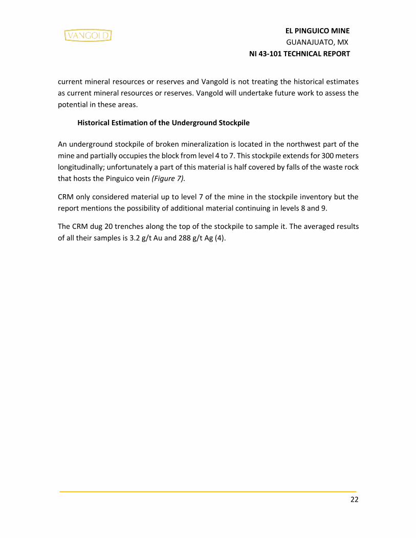
SGM took 56 samples in 19 trenches distributed over 300 meters on the stockpile. Each
trench was dug to a depth of 1.5 meters. SGM could not sample vertically deeper because
level 7 is inaccessible (see appendix 6).
Table 5 shows the assay results from the 19 trenches. SGM tried to replicate the sample
locations and results found in the CRM report (1959). SGM sampling returned an average
width of the trenches of 6.95 meters (with areas over 10 meters wide) and an average grade
of 1.662 g/t of Au and 167 g/t of Ag (with 2 samples over 8 g/t of Au and 800 g/t of Ag -
samples 15A and 22A).
26
EL PINGUICO MINE
GUANAJUATO, MX
NI 43-101 TECHNICAL REPORT
Table 5 SAMPLE ASSAYS RESULTS FROM SGM TRENCH SAMPLES FROM EL PINGUICO UNDERGROUND STOCKPILE

27
EL PINGUICO MINE
GUANAJUATO, MX
NI 43-101 TECHNICAL REPORT
The SGM trenches under the “Carson” and “Dos Estrellas” stopes are not included in their
calculations and SGM does not clarify why these three trenches were excluded. The
trenches that were left out of these calculations were:
Table 6 Assay Results that SGM did not Include in the Historical Estimate SGM (2012)
TRENCH WIDTH Au (g/ton) Ag (g/ton)
SGM 16 3.0 1.333 210
SGM 17 2.0 0.967 105 SGM 18 5.0 2.233 151
The samples taken by SGM were sent to their own laboratory in Chihuahua, Mexico. They
used fire assay method with gravimetric finish for gold and atomic absorption (AA) to
determine the silver values.
SGM classified the tonnages reported as certified and uncertified to assign a level of
confidence to their work. The certified tonnes were determined using the following data.
a) Specific gravity: 1.4 t/m3
b) Mining swell factor: 35%
c) Calculation of metric tonnage, they considered:
• Calculation of the blocked area and volume
• Calculation of the average length of the trenches
• Calculation of the average grade per block
• Tonnage calculation
SGM assigned a confidence range of 5 m below the trench bottom to the averaged trench
assay data (SGM, 2012. Certificación de reservas mineral quebrado en la Mina “El Carmen
El Pingüico” Municipio de Guanajuato, Gto).
SGM assigned 25,600 tonnes to their certified class for the underground stockpile with
averaged grades (diluted) of 1.66 g/t Au and 167 g/t Ag. This tonnage is located within 5 to
6.5 m of the top of the stockpile. The QP has not done sufficient work to classify the
historical estimate as current mineral reserves and Vangold is not treating the historical
estimate as current mineral reserves. Vangold will undertake future work to assess the
potential in these areas.

28
EL PINGUICO MINE
GUANAJUATO, MX
NI 43-101 TECHNICAL REPORT
The remaining stockpile material is classified by SGM as “uncertified” due to their inability
to sample below the trenches or homogenously throughout the remainder of the stockpile
material. They could not assign a reasonable grade to the rest of the material but assign a
tonnage of 148,900 "uncertified" tonnes (the total stockpile), and results in a final number
of 96,828 tonnes with the application of the mining swell factor (SGM,2012) (Table 7).
SGM determined the grade of the top 5m of the stockpile through trench sampling of the
material and estimated the tonnage by topographic survey and historical mine plans. SGM
did not have confidence that the grade obtained in their trench sampling reflected the
grade3 of the whole stockpile beyond a depth of 5m. SGM reported the tonnage of material
below the 5m threshold but did not assign any grade to the tonnes. None of the categories
of classification assigned by SGM comply with those set out in NI43-101 or CIM guidelines.
The work that SGM completed to estimate the tonnage of the stockpile appear reasonable
and likely reflect the amount of material in the stopes. The grade distribution throughout
the whole of the stockpile needs to be verified before it can be applied to the whole of the
tonnes available and qualify for current classification standards. Vangold will undertake
future work to assess the potential in these areas.

29
EL PINGUICO MINE
GUANAJUATO, MX
NI 43-101 TECHNICAL REPORT
Table 7 Historical Estimate for the Underground Stockpile (SGM, 2012)

30
EL PINGUICO MINE
GUANAJUATO, MX
NI 43-101 TECHNICAL REPORT
During this same year (2012) but after the SGM report was issued, EMDB decided to
perform a bulk density study of the rocks in the stockpile (with no QP supervision) to
determine if the 1.4 swell factor used by SGM in their work was conservative. EMDB
shipped the samples to an SGS certified Laboratory in Durango, Mexico.
The samples were wax coated, and weighed then submerged in water. SGS reported the
samples returned a bulk density of 2.18 g/cm3 (Table 8) and a specific gravity by picnometer
method of 2.54 g/cm3 (Table 9). The total weight of samples used to determine the older
numbers used in the CRM report is unknown. Note these are specific gravity measurement
of the individual rocks but are not representative of the stockpile as a whole.
Table 8 Bulk Density Results (SGS 2012) (WITHOUT PRESENCE OF QP)

31
EL PINGUICO MINE
GUANAJUATO, MX
NI 43-101 TECHNICAL REPORT
Table 9 SPECIFIC GRAVITY RESULTS PERFORMED BY SGS 2012 (WITHOUT PRESENCE OF QP)
To begin a validation process of these historical estimates found in both the CRM report
(1959) and the SGM report (2012), Vangold retained the author to resample the trenches
in the underground stockpile. The results of these samples are presented in Section 9.0
(Exploration) of this report.

32
EL PINGUICO MINE
GUANAJUATO, MX
NI 43-101 TECHNICAL REPORT
7.0 GEOLOGICAL SETTING AND MINERALIZATION
7.1 REGIONAL GEOLOGY
The oldest formation in the region is the Esperanza Formation (Jurassic, Ortiz-Hernández
1990), and includes carbonaceous and calcareous shales interspersed with sandstones,
limestones and flows of andesitic and basaltic lavas. The whole unit is weakly
metamorphosed into phyllites, slates and marble. The thickness of this unit exceeds 600
meters and its age has been assigned to the Cretaceous (Dávila and Martínez 1987) based
on radiolarian recognition. (Figure 4)
The La Luz Formation (Randall, 1982), overlies the Esperanza Formation and consists mainly
of intercalated layers of clastic sedimentary rocks and massive and pillow lavas, dated by
the K-Ar method at 108.4 + 6.2 Ma, (Zimmerman, in Ortiz, 1989). Locally rhyolitic tuffs and
agglomerates are present and occurrences of massive volcanogenic sulphides have been
noted. The minimum thickness or the Formation is about 1000 m.
Red Conglomerate of the Guanajuato Formation (Edwards, 1955), from Middle Eocene to
Early Oligocene, is in angular discordance with the Esperanza Formation and less frequently
with the La Luz andesite. The conglomerate consists of pebbles and cobbles with sandy
intercalations. At its base there are layers of volcanic sandstones and andesitic lavas. The
Guanajuato Red Conglomerate has a thickness that varies between 1,500 and 2,000 m and
its age is from the Late Eocene to Early Oligocene.
The overlying volcanic sequence of the middle Tertiary originates in and adjacent to a
caldera, and consists of five units described in ascending stratigraphic order:
• Loseros Formation, layers of greenish volcanic sandstone from 10 to 52 m
thick.
• (2) Bufa Rhyolitic Tuff, ash flow tuff of 360 m thickness, has been dated by
the K-Ar method at 37 + 3.0 M.a. (Gross, 1975); in the Las Torres mine, the
La Bufa rhyolitic tuff is found on the top (hangingwall) of the Veta Madre.
• (3) Calderones Formation is a greenish volcanoclastic unit which includes
lahars and a megabreccia with a thickness of 200-250 meters and rests
discordantly on the Bufa Rhyolitic Tuff.

33
EL PINGUICO MINE
GUANAJUATO, MX
NI 43-101 TECHNICAL REPORT
• (4) Cedros Andesite, has a thickness varying from 250 to 640 m and consists
of andesitic lava flows with intercalations of red layers and andesitic to
dacitic tuffs.
• (5) Chichindaro Formation is formed by a sequence of domes and lava flows
interspersed with breccias and rhyolitic volcanic tuffs (Saldaña, 1990;
Martínez, 1991). The porphyritic fluid textures are characteristics of domes
and flows. With a thickness of up 250 m and is assigned an age of 32.0 + 1.0
M.a. (Gross, 1975) according to the K-Ar method.
INTRUSIVE ROCKS
The La Luz intrusive complex located northwest of the district, consists of several phases
that intrude into the Mesozoic volcano-sedimentary sequence below the Guanajuato Red
Conglomerate. This consists of diorite, tonalite (Cerro Pelón) and dikes of various
compositions (Martínez, 1987). The basalt-diabase dikes are contemporary with the La Luz
intrusive. The tonalite of Cerro Pelón is dated to 157 + 8.8 Ma, and the diorite of Tuna Mansa
(La Palma) is dated to 122.5 + 5.6 Ma, (Zimmerman, in Ortiz et al, 1989). The volcano-
sedimentary sequence is also intruded by the San Juan de Otates ophiolite complex (Servais
et al., 1982), which consists of serpentinized peridotites, clinopyroxenites and gabbro dated
in 112 + 6.8 Ma, (Zimmerman, in Ortiz et al. Al, 1989) and outcrop about 35 km northwest
of the city of Guanajuato. (Figure 3)

34
EL PINGUICO MINE
GUANAJUATO, MX
NI 43-101 TECHNICAL REPORT
Figure 3 Regional Geology

35
EL PINGUICO MINE
GUANAJUATO, MX
NI 43-101 TECHNICAL REPORT
Figure 4 Stratigraphic Column

36
EL PINGUICO MINE
GUANAJUATO, MX
NI 43-101 TECHNICAL REPORT
Outcrops in the area of the El Carmen-El Pinguico mine are of the Tertiary formations called
Calderones y Bufa; host of the El Carmen-El Pinguico Vein. The oldest unit is the Bufa
Formation and, consists of rhyolites, tuffs and rhyolitic breccias. It has a light pink color,
thickness of approximately 500 m and hosts most of the mineralization of the El Carmen-El
Pinguico Vein. The Calderones Formation overlies the Bufa Formation and, outcrops in the
southeast portion of the mining district of Guanajuato. It consists of massive andesite, tuffs
and andesitic breccias of green color, and has a thickness of approximately 500 m.
El Pinguico-Carmen Mine, has several mining developments on parallel veins and
perpendicular to El Pinguico Vein and has little or no mine development in these veins. San
Jose and Pachuca veins, these veins have no more than two hundred meters of
development and it is unknown if they have economic values, since no historical records of
these places were found, but having development.
37
EL PINGUICO MINE
GUANAJUATO, MX
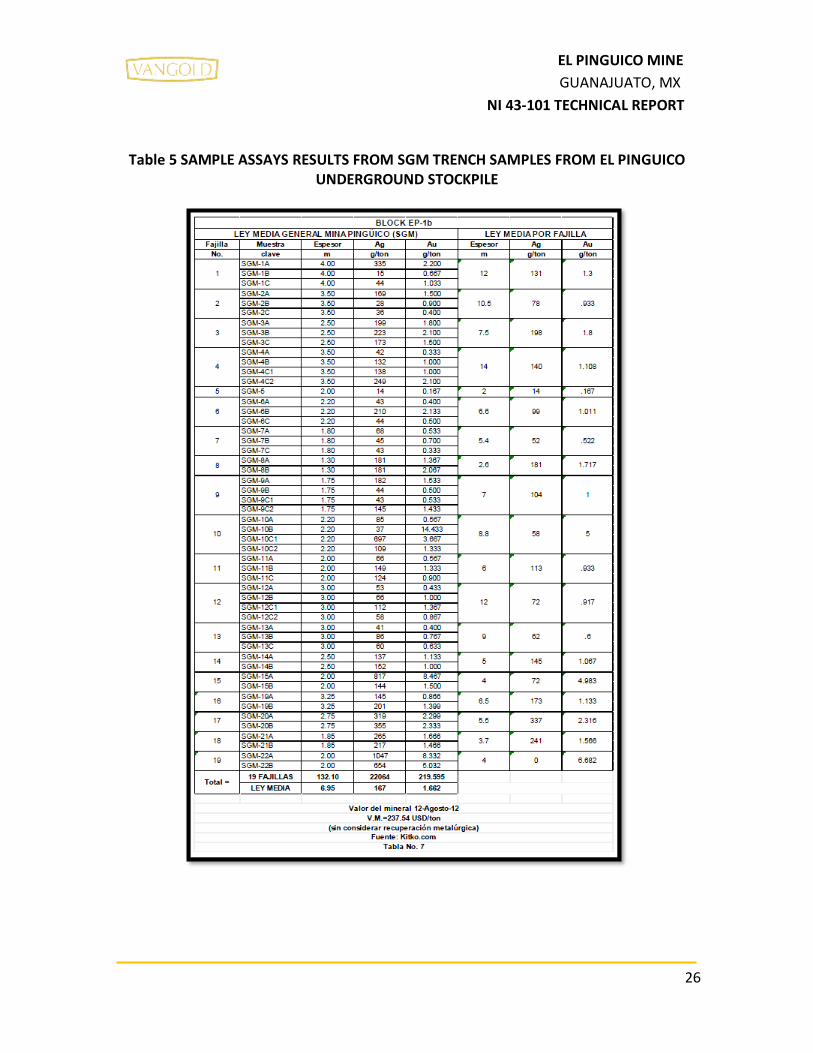
NI 43-101 TECHNICAL REPORT
Figure 5 Local Geology

38
EL PINGUICO MINE
GUANAJUATO, MX
NI 43-101 TECHNICAL REPORT
The El Carmen-El Pinguico Vein has a strike of 327°/79°NE on average. Due to its structural
position, it is considered to lie within the hangingwall (upper portion) of the large Veta
Madre Vein (which dips to the west) and tends to be cut by this. The El Carmen-Pinguico
Vein is hosted in a series of fissures and faults produced by tensional stresses and emplaced
subsequent to the great mega fault of the Veta Madre.
7.3 STRUCTURE
The Mining District of Guanajuato is a series of fault blocks delimited by normal regional
northwest-southeast faults, known as La Sierra or Villalpando System, Veta Madre System
and La Luz System. The Veta Madre system has a strike length of 20 km, Villalpando 10.5
km and La Luz 10 km. All these vein systems end in the Northern fault that is part of the
northwest-southeast fault system (Figure 6).
7.4 MINERALIZATION
The El Carmen-El Pinguico Vein is considered part of the top of the Veta Madre Vein system,
the main vein in the historic Guanajuato Silver District, and remains open at depth. The Veta
Madre vein is associated with a mega fault that outcrops for 25 kilometers with an
orientation of 135°/47°SW and is displaced in its middle part by the Amparo fault that
moves it to the northeast.
The El Pinguico Vein is one of the most important veins of El Pinguico-Carmen Mine. This
vein was emplaced in a fault/fissure zone with associated gold and silver mineralization.
The average width of the vein system is 6.95 meters and has a maximum width of 12 meters.
Gold and silver bearing fluids also carrying sulphur and iron were emplaced in the fractured
rock mass from depth with sufficient temperature and pressure drops, the fluids cooled and
the metals came out of solution and formed the Pinguico vein.
The mineralization at the Pinguico-Carmen mine, like those of the Guanajuato camp in
general, consist of a mixture of gold and silver. These occur in association with crumbling
sugar quartz veins, within brecciated rock, and as replacement in the altered rhylolite (Robt.
T. Hill, 1906). The vein has very strong argilization and silicification. The broken rocks from
the El Carmen-El Pingüico vein show sulphide mineralization in a matrix of white crystalline

39
EL PINGUICO MINE
GUANAJUATO, MX
NI 43-101 TECHNICAL REPORT
quartz, calcite and rhyolitic breccia. Mineralization consists of native gold and silver,
polybasite, pyargyrite, tetrahedrite, marcasite, sphalerite, galena, pyrite and chalcopyrite.

40
EL PINGUICO MINE
GUANAJUATO, MX
NI 43-101 TECHNICAL REPORT
Figure 6 Regional Structure and Major Vein Locations

41
EL PINGUICO MINE
GUANAJUATO, MX
NI 43-101 TECHNICAL REPORT
8.0 DEPOSIT TYPES
The majority of the deposits of the Guanajuato District, including the veins on the property,
which are part of the Veta Madre system, are of the epithermal and mesothermal types,
and appear mainly as fracture filling, although there are also important areas with
stockwork veins.
It should be noted that with consideration of the vein mineralogy, the mineralization
gangue minerals and the alteration, the vein system could be classified as adularia-sericite
type epithermal veins, or within the intermediate sulphidation type epithermal deposits
(Camprubí and Albinson, 2006). Such epithermal deposits are a major source of gold and
silver mining in many parts of the world.

42
EL PINGUICO MINE
GUANAJUATO, MX
NI 43-101 TECHNICAL REPORT
9.0 EXPLORATION
9.1 2017 SAMPLING PROGRAM OF THE UNDERGROUND STOCKPILE
VANGOLD hired FINDORE S.A. DE C.V. (the author´s Geological Services Company in Mexico)
to take samples of the underground stockpile, to compare to the sampling done by CRM in
1959 and SGM in 2012 (all the field work supervised by the author). Vangold took these
samples to initiate a due diligence review of the historical estimates by comparing the
sample results from the CRM and SGM studies.
To perform this work, the author with two other geologists and five hired laborers dug out
the trenches in the mine and took new stock pile samples in as close proximity to the
historical samples as possible. All samples were then carried to surface for dispatch to the
assaying laboratory. Fortunately, all the SGM trenches were easily located by the trench ID
number marked on the mine walls. The top material in each trench was dug out to remove
rocks that may have fallen into the trenches from the surrounding areas. In most of the
trenches, it was possible to dig below the level of the SGM sampling. Guidance was provided
by one of the workers who was present during the SGM 2012 sampling program. Figure 8
and Figure 9 show the location of the trenches that were excavated by the SGM in 2012 and
again in 2017 by the author.
Findore located 20 trenches of different lengths in different parts of the stockpile and were
distributed over 340 meters (approximate length of the stockpile). Most of the trenches
were sampled as close to the location where the CRM (1959) and SGM (2012) samples were
taken. A few new trenches were dug to sample the rocks were it was not safe to sample
the older trenches. The stockpile is very unstable in places so it is very dangerous and it
requires great care to work in this area.
Each sample was taken along the floor of the trench to be representative of the rock
exposed in the trench. The sample bag was then sealed and secured underground until
transported to the surface. A total of 57 samples were obtained from the trenches in the
stockpile and sent for analysis. Twenty of these same samples were analyzed for specific
gravity. The samples taken were representative of the material in the trenches and all the
rocks collected in the sampling were collected in an unbiased way to reflect the bulk of the
material in the stockpile.

43
EL PINGUICO MINE
GUANAJUATO, MX
NI 43-101 TECHNICAL REPORT
9.2 Specific Gravity Analysis Results
From the 20 samples the specific gravity “of the samples” from the stockpile averaged to
2.566 g/cm3. This is the specific gravity of the rocks within the pile but not of the whole
stockpile. Piled and irregularly shaped rocks have air spaces between them. Historically,
CRM (1959) and SGM (2012) have applied a specific gravity value to the stockpile of 1.4. The
author has reviewed their determinations and finds this to be a reasonable number.
Table 10 SPECIFIC GRAVITY OF THE SAMPLES TAKEN BY THE AUTHOR FROM THE STOCKPILE AVERAGED TO 2.566 g/cm3
Sample # Specific Gravity
(g/cm3)
F-001 2.75 F-003 2.58
F-005 2.6
F-007 2.54
F-009 2.66
F-012 2.71 F-014 2.55
F-022 2.53
F-026 2.46
F-030 2.44
F-034 2.53 F-036 2.53
F-038 2.52
F-042 2.56
F-046 2.57
F-049 2.52 F-054 2.54
F-060 2.47 F-062 2.52
F-064 2.74
AVERAGE 2.566
In 2012, EMDB took samples (without QP supervision) to undertake specific gravity and bulk
density measurements. These samples were sent to a certified laboratory in Durango,
Mexico (SGS) and returned a specific gravity of 2.54 and a density Bulk of 2.18 g/cm3.

44
EL PINGUICO MINE
GUANAJUATO, MX
NI 43-101 TECHNICAL REPORT
Comparing the results of the samples taken by EMBD and those taken by the author, the
results are very similar (Table 8 and Table 9).
9.3 2017 Trench Sample Assay Results
The tables in this section show the location data for each trench and the gold and silver
assay results for each sample taken by the author in the El Pinguico underground stockpile.
The results from the 2017 sampling program confirm the grades found by SGM (2012) as
most of the individual sample results and the overall average grades a close in gold and
silver values. There is a week bias in the results where the 2017 samples returned a slightly
higher averaged value (1.75 g/t Au and 183.58 g/t Ag) than SGM samples (1.662 g/t Au and
143 g/t Ag). The samples from the CRM (1959) study, show much higher gold and silver
values than SGM or the 2017 samples, 2.72 g/t Au and 251 g/t Ag. The higher results in the
58 year old study may be correct as the stockpile may not have been so covered or diluted
by falls of waste rock from the walls of the mine as they appear to be in 2017 (Table 11 to
Table 13, and Figure 7 to Figure 10):
Table 11 Comparison of Assay Results for the Underground Stockpile Trench Samples CRM (1959), SGM (2012) and Vangold (2017)
CRM (1959) SGM (2012) VANGOLD (Taken by the
author in 2017)
TRENCH Width
(m) Au
gr/ton Ag
gr/ton TRENCH
Width (m)
Au gr/ton
Ag gr/ton
TRENCH Width
(m) Au
gr/ton Ag
gr/ton COMMENTS
M180 3.0 5 565 Not sampled by
VANGOLD
M179 3.5 11 1377 Not sampled by
VANGOLD
M178 5 5.5 593 Not sampled by
VANGOLD
M177 6.4 1 119 22 4 6.682 851 F19 4 5.675 709
F18 4 10.725 1042 Made by VANGOLD, not sampled by CRM
or SGM
F17 5.5 2.93 452 Made by VANGOLD, not sampled by CRM
or SGM
F16 4 0.339 25.75 Made by VANGOLD, not sampled by CRM
or SGM
M176 8.4 1.8 108 15 4 4.983 72 F15 7.5 0.9965 100.55

45
EL PINGUICO MINE
GUANAJUATO, MX
NI 43-101 TECHNICAL REPORT
CRM (1959) SGM (2012) VANGOLD (Taken by the
author in 2017)
TRENCH Width
(m) Au
gr/ton Ag
gr/ton TRENCH
Width (m)
Au gr/ton
Ag gr/ton
TRENCH Width
(m) Au
gr/ton Ag
gr/ton COMMENTS
M175 8.6 1.6 138 14 5 1.067 145 F14 5 1.3225 132.5
M174 9.4 5.3 511 13 9 0.6 62 F13 9 1.1587 108.2
M173 12.6 1.5 117 12 12 0.917 72 Not sampled by
VANGOLD
M172 5.5 2.2 218 11 6 0.933 113 F11 6 1.205 173.67
M171 8.7 1.2 115 10 8.8 5 58 F10 8.8 0.416 47.55
M170 6.6 2 180 9 7 1 104 F9 7 1.706 121.23
M169 2.75 1.2 158 8 2.6 1.717 181 F8 2.6 1.5675 116.25
M168 5.5 1 119 7 5.4 0.522 52 F7 3.2 0.8355 102.75
M167 10.5 3 237 6 6.6 1.011 99 F6 6.6 1.6307 135.13
M166 5.5 - 40 5 2 0.167 14
Not sampled by VANGOLD,CRM does
not use it for averages
M165 15.2 4 202 4 14 1.108 140 F4 14 1.5683 147.08
M164 8 4.2 232 3 7.5 1.8 198 F3 7.5 2.0783 194.33
M163 8.5 2.4 178 2 10.5 0.933 78 F2 10.5 0.626 66.967
M162 10 1.2 290
M161 11.8 1.76 230 1 12 1.3 131 F1 12 1.14 60.1
19 6.5 1.133 173 F18-A 4.4 1.9475 194.5 Sampled only by
SGM an VANGOLD
20 5.5 2.316 337 F17-A 2 1.24 383 Sampled only by
SGM an VANGOLD
21 3.7 1.566 241 F16_A 4.71 1.7217 250 Sampled only by
SGM an VANGOLD
AVERAGE 7.89 2.72 251 6.95 1.66 143 6.42 1.75 183.58
*NOTE: This table does not show the results of the trenches 16, 17 and 18 of the SGM, because they were not used to
calculate averages, the results of these trenches were shown in table 9.

46
EL PINGUICO MINE
GUANAJUATO, MX
NI 43-101 TECHNICAL REPORT
The trenches located below the “Carson” and “Dos Estrellas” stopes (north side of the
stockpile) have higher values in the CRM sampling than the later sampling. This may be due
to waste rock slumping into these stopes and diluting the mineralized material on the top
of the stock pile.
Trenches under “Carson” and “Dos Estrellas” stopes:
CRM: M174, M175, M176, M177, M178, M179 and M180.
SGM: 19, 20, 21 and 22 (last 3, shown in table 9).
VANGOLD: F16, F17, F18, F19 and F20.
In the trenches on the other side (south side of the stockpile), there is a very slight increase
in Au and Ag values, this may be due to mineralized material falling from open stopes above
as these trenches are under Block 3 area of the mine.
Trenches under “BLOCK 3” calculated by CRM in 1959:
CRM: M161, M162, M163, M164 and M165.
SGM: 1, 2, 3, and 4.
VANGOLD: F1, F2, F3 and F4.

47
EL PINGUICO MINE
GUANAJUATO, MX
NI 43-101 TECHNICAL REPORT
Table 12 Locations of the Vangold 2017 Trenches (Associated Figure 7 and Figure 8)
TRENCH # LONG SAMPLES DIRECTION
1 12.0 meters F-052, F-053, F-054, F-
055 Southwest to
northeast
2 10.5 meters F-049, F-050, F-051 Southwest to
northeast
3 7.5 meters F-046, F-047, F-048 Southwest to
northeast
4 14.0 meters F-041, F-042, F-043, F-
44, F-45 Southwest to
northeast
6 6.6 meters F-038, F-039, F-040 Southwest to
northeast
7 3.2 meters F-036, F-037 Southwest to
northeast
8 2.6 meters F-034, F-035 Southwest to
northeast
9 7 meters F-029, F-030, F-031, F-
32, F-33 Southwest to
northeast
10 8.8 meters F-025, F-026, F-027, F-
28 Southwest to
northeast
11 6 meters F-022, F-023, F-024 Southwest to
northeast
13 9.0 meters F-014, F-015, F-016 Southwest to
northeast
14 5.0 meters F-012, F-013 Southwest to
northeast
15 7.5 meters F-009, F-010, F-011 Southwest to
northeast
16 4.0 meters F-007, F-008 Southwest to
northeast
17 5.5 meters F-005, F-006 Southwest to
northeast
18 4.0 meters F-003, F-004 Southwest to
northeast
19 4.0 meters F-001, F-002 Southwest to
northeast

48
EL PINGUICO MINE
GUANAJUATO, MX
NI 43-101 TECHNICAL REPORT
TRENCH # LONG SAMPLES DIRECTION
16-A 4.7 meters F-064, F-065, F-066 Southwest to
northeast
17-A 2.0 meters F-062, F-063 Southwest to
northeast
18-A 4.4 meters F-060, F-061 Southwest to
northeast

49
EL PINGUICO MINE
GUANAJUATO, MX
NI 43-101 TECHNICAL REPORT
Figure 7 Stockpile Longsection

50
EL PINGUICO MINE
GUANAJUATO, MX
NI 43-101 TECHNICAL REPORT
Figure 8 Location of the 2017 Vangold Trenches on the Underground Stockpile

51
EL PINGUICO MINE
GUANAJUATO, MX
NI 43-101 TECHNICAL REPORT
Table 13 Assay Results for 2017 Trench Samples (Samples Collected by the Author) from El Pinguico Underground Stockpile
GENERAL MIDDLE VALUES OF THE EL PINGUICO STOCKPILE
MIDDLE VALUES PER TRENCH
TRENCH SAMPLE WIDTH (m) Au
(gr/ton) Ag
(gr/ton) WIDTH (m)
Au (gr/ton)
Ag (gr/ton)
1
F-052 4.00 1.145 20
12.00 1.14 60.10 STANDARD
F-054 4.00 1.005 27.3
F-055 4.00 1.27 133
2
F-049 3.50 0.672 49
10.50 0.63 66.97 F-050 3.50 0.304 32.9
F-051 3.50 0.902 119
3
F-046 2.50 2.45 226
7.50 2.08 194.33 F-047 2.50 1.855 182
F-048 2.50 1.93 175
4
F-041 3.50 0.816 87.4
14.00 1.57 147.08
F-042 3.50 1.965 185
BLANK
F-044 3.50 2.66 242
F-045 3.50 0.832 73.9
6
F-038 2.20 3.21 270
6.60 1.63 135.13 F-039 2.20 0.662 60.5
F-040 2.20 1.02 74.9
7 F-036 1.60 0.531 61.5
3.20 0.84 102.75 F-037 1.60 1.14 144
8 F-034 1.30 1.895 153
2.60 1.57 116.25 F-035 1.30 1.24 79.5
9
F-029 1.75 0.648 48.8
7.00 1.71 121.23
F-030 1.75 0.736 70.1
F-031 1.75 1.65 144
F-032 1.75 3.79 222
STANDARD
10
F-025 2.20 0.214 20.4
8.80 0.42 47.55 F-026 2.20 0.403 30.5
F-027 2.20 0.596 73.5
F-028 2.20 0.451 65.8

52
EL PINGUICO MINE
GUANAJUATO, MX
NI 43-101 TECHNICAL REPORT
GENERAL MIDDLE VALUES OF THE EL PINGUICO STOCKPILE
MIDDLE VALUES PER TRENCH
TRENCH SAMPLE WIDTH (m) Au
(gr/ton) Ag
(gr/ton) WIDTH (m)
Au (gr/ton)
Ag (gr/ton)
11
F-022 2.00 1.08 207
6.00 1.21 173.67 F-023 2.00 1.48 174
F-024 2.00 1.055 140
13
F-014 3.00 1.895 186
9.00 1.16 108.20 F-015 3.00 1.105 94.8
F-016 3.00 0.476 43.8
14 F-012 2.50 1.3 146
5.00 1.32 132.50 F-013 2.50 1.345 119
15
F-009 3.75 1.015 118
7.50 1.00 100.55 F-010 3.75 0.978 83.1
BLANK
16 F-007 2.00 0.657 49.4
4.00 0.34 25.75 F-008 2.00 0.021 2.1
17 F-005 2.75 3.78 558
5.50 2.93 452.00 F-006 2.75 2.08 346
18 F-003 2.00 15.7 1475
4.00 10.73 1042.00 F-004 2.00 5.75 609
19 F-001 2.00 4.83 466
4.00 5.68 709.00 F-002 2.00 6.52 952
16-A
F-064 1.57 2.2 255
4.71 1.72 250.00 F-065 1.57 1.47 216
F-066 1.57 1.495 279
17-A F-062 2.00 1.24 383
2.00 1.24 383.00 F-063 STD 0.992 66.1
18-A F-060 2.20 1.135 131
4.40 1.95 194.50 F-061 2.20 2.76 258

53
EL PINGUICO MINE
GUANAJUATO, MX
NI 43-101 TECHNICAL REPORT
Figure 9 Comparative Graph Showing Averaged Gold Results for Underground Stockpile
Sampling by CRM(1959), SGM (2012) AND VANGOLD (2017)
Figure 10 Comparative Graph Showing Averaged Silver Results for Underground Stockpile Sampling by CRM(1959), SGM (2012) AND VANGOLD (2017)
0
0.5
1
1.5
2
2.5
3
CRM SGM VANGOLD
Au (g/ton)
0
50
100
150
200
250
300
CRM SGM VANGOLD
Ag (g/ton)

54
EL PINGUICO MINE
GUANAJUATO, MX
NI 43-101 TECHNICAL REPORT
With the 2017 sampling program, Vangold has confirmed the assay data used by SGM in
their 2012 study is reasonable and reproducible. Vangold will complete further study work
on the underground stockpile to confirm the tonnage estimations in the historical estimate
reports and assess the distribution of the grade within the stockpile material.

55
EL PINGUICO MINE
GUANAJUATO, MX
NI 43-101 TECHNICAL REPORT
10.0 DRILLING
No drilling has been carried out in El Pinguico Project.

56
EL PINGUICO MINE
GUANAJUATO, MX
NI 43-101 TECHNICAL REPORT
11.0 SAMPLE PREPARATION, ANALYSES AND SECURITY
The 2017 samples, were collected, recorded, bagged and sent by the author personally to
the ALS Laboratory in Guadalajara for sample preparation. The gold, silver and multielement
ICP analysis and specific gravity measurements were completed at the ALS laboratory in
North Vancouver, Canada. ALS is an independent and globally commercial assay laboratory
company that has ISO 17025:2005 certification for its laboratory analysis work.
Rock samples were fine crushed (70% passing a 2mm screen), pulverized (85% passing a 75
micron screen) and a pulp split separated for assaying by a riffle splitter. 30 gram portion of
each sample was assayed for gold by standard fire assay and a 10 gram split was analysed
for 35 elements by ICP method.
Twenty of these same samples were analysed for specific gravity on pulps using a
pycnometer.
Standard Reference Material (SRM) were purchased from CDN Resource Laboratories Ltd.
In Vanocuver, Canada and blank samples (Quaternary andesite, from Guanajuato) were
inserted into the sample stream at a 5% insertion rate with pulped samples from the
underground stockpile for quality control purposes. The results of the standards and blank
samples were satisfactory as presented in Table 14.
Table 14 Assay Results and Expected Value for Standard Reference Material and Blank Samples
SAMPLE TYPE Au (ppm) Ag (ppm)
Reference
values for the
standards Au
(ppm)
Reference
values for the
standards Ag
(ppm)
F-011 BLANK 0.007 0.5
F-033 STANDARD 0.861 67 0.896 g/t 64.7 g/t
F-043 BLANK 0.016 1.5
F-053 STANDARD 0.463 38.4 0.452 g/t 38.2 g/t

57
EL PINGUICO MINE
GUANAJUATO, MX
NI 43-101 TECHNICAL REPORT
In the opinion of the author the sampling, sample preparation, security and analytical
procedures were all completed to a reliable standard.
12.0 DATA VERIFICATION
The analytical data included in this report was taken from the ALS certificates addressed to
VANGOLD and copied to the author. Through observation and sampling, the author has
verified a set of data collected by FINDORE. The data was all collected with industry
standard practices and assay results appear reasonable
The author personally supervised the sampling work of the underground stockpile, over
four days on the project and is directly responsible for collection of samples from the
underground stockpile at the mine in the El Pinguico zone.

58
EL PINGUICO MINE
GUANAJUATO, MX
NI 43-101 TECHNICAL REPORT
13.0 MINERAL PROCESSING AND METALLURGICAL TESTING
No mineral processing nor metallurgical tests were conducted in the property.
14.0 MINERAL RESOURCES ESTIMATES
No current mineral resource estimation has been conducted in the property.

59
EL PINGUICO MINE
GUANAJUATO, MX
NI 43-101 TECHNICAL REPORT
15.0 ADJACENT PROPERTIES
The El Pinguico Mine is located approximately 2.5 km from Mina Las Torres, Fresnillo plc.
and is located approximately 4.5 km from Endeavor Silver’s El Cubo mine, where 3 mines
feed a flotation plant that produces mineral concentrates (Figure 13).
The geology of El Cubo mine is low-sulphidation epithermal veins which are typically
thousands of metres long, 400 metres deep, and 1 to 3 metres thick.
As reported in their 2017 report, “National Instrument 43-101 Technical Report: Updated
Mineral Resource and Reserve Estimates for the El Cubo Project, Guanajuato State,
Mexico”, (Effective Date, December 31, 2017), their current resources and reserves are as
follows,
Figure 11 Mineral Resource Estimate for Endeavor Silver’s El Cubo Mine, Effective date December 31, 2017 (Endeavor Silver, 2017)
The author has been unable to verify the information and the information is not necessarily
indicative of the mineralization on the property that is the subject of this technical report.
Figure 12 Mineral Reserve Estimate for Endeavor Silver’s El Cubo Mine, Effective date December 31, 2017 (Endeavor Silver, 2017)
The author has been unable to verify the information and the information is not necessarily
indicative of the mineralization on the property that is the subject of this technical report.
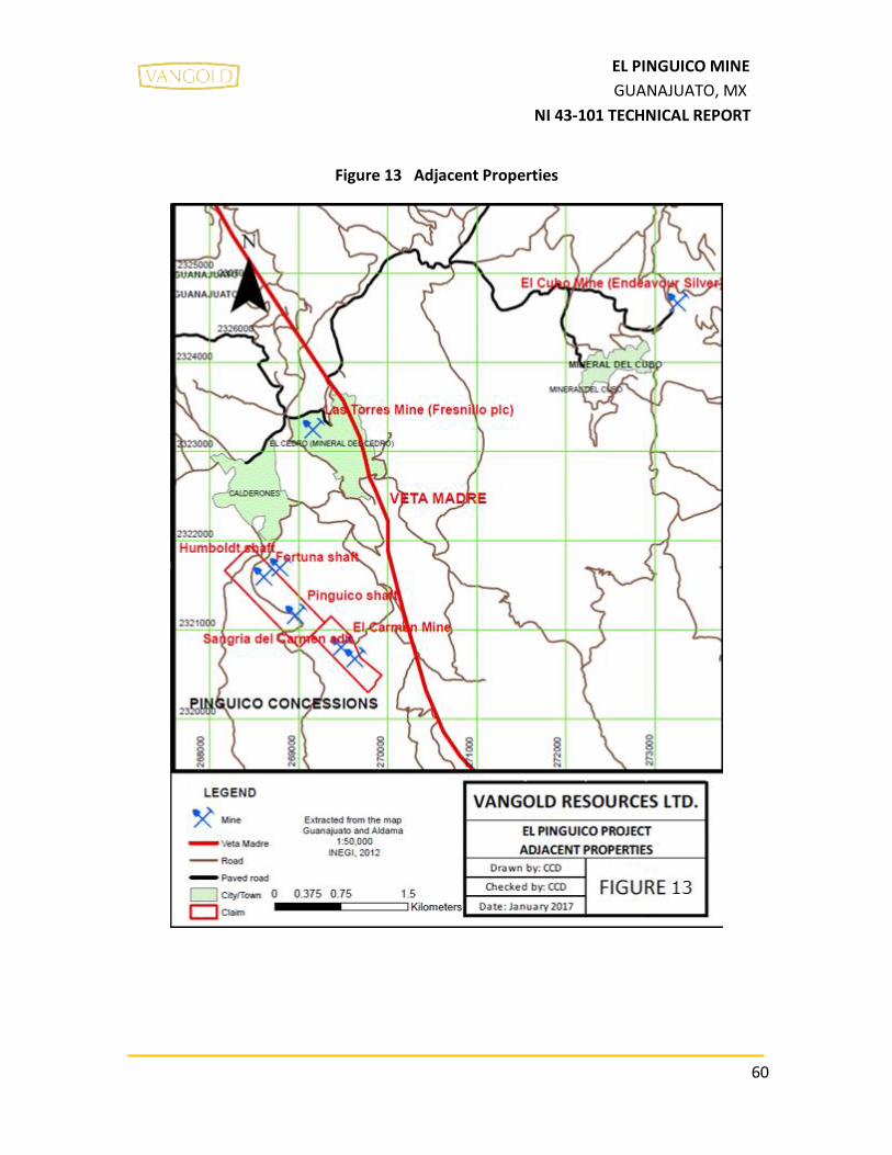
60
EL PINGUICO MINE
GUANAJUATO, MX
NI 43-101 TECHNICAL REPORT
Figure 13 Adjacent Properties

61
EL PINGUICO MINE
GUANAJUATO, MX
NI 43-101 TECHNICAL REPORT
16.0 OTHER RELEVANT DATA AND INFORMATION
The author is not aware of any other relevant material data and information that would
result in misleading statements.

62
EL PINGUICO MINE
GUANAJUATO, MX
NI 43-101 TECHNICAL REPORT
17.0 INTERPRETATION AND CONCLUSIONS
Vangold Resources Ltd. signed an agreement with Exploraciones Mineras Del Bajío S.A. de
C.V. to acquire the 100% interest of the El Pinguico Property, which contains two mining
concessions of 71 Hectares.
The El Pinguico project has several mine workings with more than 10 other old workings
within the property. The focus is currently on the El Pinguico-Carmen Mine, which has
several vertical shafts: the Humboldt shaft of 397 meters depth, the Pinguico shaft of 283
meters, the Fortuna shaft of 303 meters, the El Centro shaft of 200 meters and the
Carmencitas shaft of 61 meters. The mine is currently not in operation and has not been in
operation since 1913 but access to the underground workings is available through the El
Carmen adit on level 4.
Inside the El Pinguico-Carmen mine, there is a large underground stockpile in the area of
the El Pinguico vein. Two Mexican government agencies have completed historical
estimation studies (CRM in 1959 and SGM in 2012), and Vangold will undertake work
programs to assess these Historical estimation results. The reports by CRM is not very
detailed and there is little information available regarding their estimates. Vangold is of the
opinion that these historical estimates present results that are encouraging enough for
them to acquire the property but realize the studies are not to be relied upon and they are
planning future work programs to assess the results from these studies.
In 1959, CRM completed a sampling program and a topographic survey of the stockpile.
They reported historical estimates of 103,415 tonnes of stockpile material with an average
grade of 2.72 g/t Au and 251 g/t Ag they classed in probable category. The CRM also made
an estimation of insitu vein material and reported a historical estimate results of 4,921
tonnes with an average grade of 5.4 g/t Au and 424 g/t Ag into the probable category. The
reports by CRM is not very detailed and there is little information available regarding the
key assumptions, parameters and methods used for the estimates. CRM estimated the
tonnages of the in situ veins using polygonal blocks but did not report the ranges of
confidence for the blocks. The grades used in the estimate were obtained through channel
sampling in stopes of the vein material. To assess the potential of the insitu vein material,
Vangold should resample the areas outlined in the historical estimates area and plan a drill
program to test the vein material beyond the underground workings. The CRM classified
the historical estimates as probable reserves but due to the uncertainty associated with the

63
EL PINGUICO MINE
GUANAJUATO, MX
NI 43-101 TECHNICAL REPORT
grade distributions beyond the vein exposures underground, the QP would not place them
in this category using current CIM guidelines for Probable Mineral Reserves. The QP has
not done sufficient work to classify the historical estimate as current mineral resources or
reserves and Vangold is not treating the historical estimates as current mineral resources
or reserves. Vangold will undertake future work to assess the potential in these areas.
Then in 2012, SGM completed an estimation of the same underground stockpile and
reported finding 25,600 tonnes with an average grade of 1.667 g/t Au and 143 g/t Ag, in
their “Certified” tonnage category and put 96,828 tonnes into their uncertified category.
SGM classified the historical estimate into “certified” tonnes and grade for the top 5 m of
the stockpile and only gave uncertified tonnage estimate for the remaining material with
no grade estimated. SGM determined the grade of the top 5m of the stockpile through
trench sampling of the material and estimated the tonnage by topographic survey and
historical mine plans. SGM did not have confidence that the grade obtained in their trench
sampling reflected the grade3 of the whole stockpile beyond a depth of 5m. SGM reported
the tonnage of material below the 5m threshold but did not assign any grade to the tonnes.
None of the categories of classification assigned by SGM comply with those set out in NI43-
101 or CIM guidelines. The work that SGM completed to estimate the tonnage of the
stockpile appear reasonable and likely reflect the amount of material in the stopes. The
grade distribution throughout the whole of the stockpile needs to be verified before it can
be applied to the whole of the tonnes available and qualify for current classification
standards. The QP has not done sufficient work to classify the historical estimate as current
mineral resources or reserves and Vangold is not treating the historical estimates as current
mineral resources or reserves.
The QP accepts these two historical estimates as reasonable estimates of the tonnage of
stockpile material available in the underground workings and recommends that Vangold
undertake a study to further assess the distributions of the grade throughout the whole of
the stockpile.
In 2017, VANGOLD hired Findore, the author’s company, to resample the underground
stockpile and assess the gold and silver values reported in the CRM (1959) and SGM (2012)
reports. Vangold took these first steps to initiate a due diligence review of the historical
estimates.
They gathered and analyzed 57 samples from the trenches on the stockpile. The results
confirmed the grades found by SGM (2012) where Vangold’s results averaged 1.75 g/t Au

64
EL PINGUICO MINE
GUANAJUATO, MX
NI 43-101 TECHNICAL REPORT
and 183.58 g/t Ag and SGMs averaged to 1.662 g/t Au and 143 g/t Ag. The oldest samples
from the CRM (1959) study have much higher gold and silver values than SGM or Vangold
with 2.72 g/t Au and 251 g/t Ag. It is the author’s opinion the higher results may be due to
rock slumps of waste rock from the walls of the mine. Vangold is pleased that the 2017
sampling program found similar results in gold and silver grades to the historical work and
they will undertake further study work on the underground stockpile to review the tonnage
estimations in the historical estimate reports and assess the distribution of the grade within
the stockpile material
Due to the 2017 stockpile sampling results obtained by VANGOLD and since there has been
no significant mineral extraction or exploration on the El Pinguico-Carmen Mine property
since it was closed in 1913, the author considers the El Pinguico project has potential for
hosting gold and silver mineralization and merits further exploration work. The property
has been minimally explored in the past and there is no evidence of any drilling completed
on the property. After Vangold completes their initial surface investigations of the property,
including mapping, they will assess the potential for vein material in the mine and the
parallel vein systems both along strike and at depth.
The author believes that the only risk or uncertainty that can be expected is that the trench
samples do not necessarily demonstrate the grade of the whole stockpile.

65
EL PINGUICO MINE
GUANAJUATO, MX
NI 43-101 TECHNICAL REPORT
18.0 RECOMMENDATIONS
In 2017, Vangold was able to confirm the historical grades used to support the historical
estimates. Now the company would like to continue this work of investigating the potential
of the underground stockpile but also wants to gather all available data on the project into
a project database and begin surface and underground investigations. There is a lot of
information to gather and synthesize before the next phase of exploration can be planned.
The mining on the project stopped in the early 1900s and there has been little exploration
completed on the project, specifically there are no records of any drilling being done. After
Vangold completes their initial surface investigations of the property, including mapping,
they will assess the potential for vein material in the mine and the parallel vein systems
both along strike and at depth.
Specifically the author recommends
Phase 1: exploration work that includes a basic surface exploration program:
• Analysis and interpretation of satellite images: This is for the possible location of any
structures on the surface of the property, such veins or faults.
• Sampling the dump on the surface (rent a backhoe).
• Geochemical soil sampling: Make a geochemical grid of soil samples to locate
possible areas of interest.
• Surface geological survey: Detailed mapping of lithological units (1:2,000 scale),
alterations, structures and mineralization, all with their respective rock sampling.
• Data digitization: Integration of all the data taken in the field into a project database.
• Written Report to summarize the findings.
Total budget to complete Phase 1 program $107,000.00 CAD per 45 days and includes 1
Mexican QP, 1 Mexican senior geologist, 1 junior geologist, cost of the assays, equipment
rental, field assistants as required.

66
EL PINGUICO MINE
GUANAJUATO, MX
NI 43-101 TECHNICAL REPORT
Mexican taxes and others (In Mexico there is a sales tax called “Impuesto al Valor Agregado”
I.V.A.) 16% of the Phase 1: $17,120.00 CAD.
Labour $35,000.00
Equipment Rental $32,000.00
Sample Analysis Costs $40,000.00
Phase 1 $107,000.00 CAD
I.V.A. Tax $ 17,120.00 CAD
TOTAL $ 124,120.00 CAD
Rounding this, we can have a general number for the costs:
Total budget to complete Phase 1 program $125,000.00 CAD
67
EL PINGUICO MINE
GUANAJUATO, MX
NI 43-101 TECHNICAL REPORT
19.0 REFERENCES
• SGM (2012). Certificación de reservas mineral quebrado en la Mina “El Carmen El
Pingüico” Municipio de Guanajuato, Gto. 3 maps, 1 stratigaphic column, 1 table, p.
5-8, 11, 17-20
• Consejo de Recursos Naturales no Renovables, Ming. Meave, 1959. “Estudio
geológico minero de la zona “El Pingüico” Distrito minero de Guanajuato, Gto. p. 2-
5, 24-26 and 29
• Unknown autor report, 1945.
• Reports on the Pinguico Mine, Guanajuato; Mexico, 1906. Prof. Robt. T. Hill, Mr. E.A.
Wiltsee, E.M., Prof. J.A. Church, E.M., A.B. Carpenter, E.M. and J.B. Empson, E.M.
• Heredia, E y Polanco, R., (Sept 14, 2012): Determinación densidad bulk y gravedad
especifica con picnómetro. Preparado para Exploraciones Mineras del Bajío, S.A.
de C.V. -Reporte SGS-65-12. SGS MINERALS SERVICES/DURANGO. p. 1-6
• SGM (2014) Panorama minero del Estado de Guanajuato. p. 41, 42 and 67
• Orozco Villaseñor Francisco Javier (2014). Mineralogía y génesis del “clavo de Rayas”
de la zona central de la Veta Madre de Guanajuato. p. 58
• Juan José Martínez-Reyes, Antoni Camprubí, I. Tonguç Uysal, Alexander Iriondo,
Eduardo González-Partida (2015). Geochronology of Mexican mineral deposits. II:
Veta Madre and Sierra epithermal vein systems, Guanajuato district. p. 1-6
• Vasallo, F, L, Martínez, R, J y Paris, J, P. (1996): Estructuras circulares y lineales en el
Distrito Minero de Guanajuato. p. 252-255
• Antoni Camprubí, Eduardo González-Partida, Gilles Levresse, Jordi Tritlla y Alejandro
Carrillo-Chávez (2003). Depósitos epitermales de alta y baja sulfuración: una tabla
comparativa. p. 10-16
• SGM (2002) Carta geológico-Minera Aldama F14-C53 1:50,000 Guanajuato.
• INEGI (1975) Carta geológica Aldama F14-C53 1:50,000 Primer edición, Guanajuato.
• INEGI (2015) Carta topográfica Aldama F14-C53 1:50,000 cuarta edición,
Guanajuato.
• SGM (1998): Carta Geológico-Minera Guanajuato Clave F14-C43 1:50, 000,
Guanajuato.
• http://www.mexicominingcenter.com/newsdetail.php?chapter=9034&date=Janua
ry%2005,2017 (january, 2017)

68
EL PINGUICO MINE
GUANAJUATO, MX
NI 43-101 TECHNICAL REPORT
• http://www.cuentame.inegi.org.mx/monografias/informacion/gto/territorio/clima
.aspx?tema=me&e=11 (January 2016)
• http://www.inafed.gob.mx/work/enciclopedia/EMM11guanajuato/mediofisico.ht
ml (January 2016)
• Endeavour Silver, 2017, “National Instrument 43-101 Technical Report: Updated
Mineral Resource and Reserve Estimates for the El Cubo Project, Guanajuato State,
Mexico”, (Effective Date, December 31, 2017), March 3, 2017.
• http://www.cuentame.inegi.org.mx/monografias/informacion/gto/territorio/recur
sos_naturales.aspx?tema=me&e=11 (January 2016)
• ALS (2016), Schedule of Services & Fees. P. 13 and 23.
• SGM (2012) MINA EL CARMEN-EL PINGÜICO, Planta y sección longitudinal A-A´,
mostrando geología, zanjas (muestreo) y estimación de recursos minerales, Mpio.
De Guanajuato, Guanajuato.
• VGH, Servicios Legales, S.C. (February 2017) Titled opinion, Mining concessions, El
Pinguico Project
• VANGOLD NEWS RELEASE, Vancouver, B.C. / TheNewswire / January 5, 201
20.0 APPENDICES

69
EL PINGUICO MINE
GUANAJUATO, MX
NI 43-101 TECHNICAL REPORT
APPENDIX 1. CERTIFIED LABORATORY ANALYSES FOR THE SAMPLES COLLECTED IN THE STOCKPILE BY THE AUTHOR

70
EL PINGUICO MINE
GUANAJUATO, MX
NI 43-101 TECHNICAL REPORT

71
EL PINGUICO MINE
GUANAJUATO, MX
NI 43-101 TECHNICAL REPORT

72
EL PINGUICO MINE
GUANAJUATO, MX
NI 43-101 TECHNICAL REPORT

73
EL PINGUICO MINE
GUANAJUATO, MX
NI 43-101 TECHNICAL REPORT

74
EL PINGUICO MINE
GUANAJUATO, MX
NI 43-101 TECHNICAL REPORT
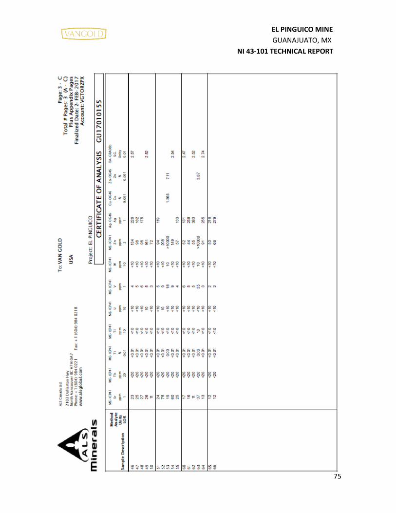
75
EL PINGUICO MINE
GUANAJUATO, MX
NI 43-101 TECHNICAL REPORT

76
EL PINGUICO MINE
GUANAJUATO, MX
NI 43-101 TECHNICAL REPORT

77
EL PINGUICO MINE
GUANAJUATO, MX
NI 43-101 TECHNICAL REPORT

Carlos Cham Domínguez C.P.G.
APPENDIX 2. FRAGMENTARY PROJECTION OF THE CARMEN MINE WITH ASSAYS (LEVELS 7, 8, PINGUICO MINE COMPANY, 1909)
NOTE: Assays read from left to right in following order: No. – Width – Au grams – Ag grams

Carlos Cham Domínguez C.P.G.
APPENDIX 3. PINGUICO MINE, PLAN OF 145 LEVEL WITH ASSAYS (HISTORICAL ARCHIVE OF THE UNIVERSIDAD DE GUANAJUATO, 1907)
NOTE: blue figures = values U.S.C., black = widths in meters
27 samples taken showing USD/ton 45 samples 54 samples
Average of $52 USD/ton Average of $53 USD/ton Average of $42 USD/ton
8 meters width over 9 meters width 9 to 10 meters width of stope

Carlos Cham Domínguez C.P.G.
APPENDIX 4. LONGITUDINAL STOPE SHOWING VALUES BETWEEN LEVELS 7 AND 8 (HISTORICAL MAP OF PINGUICO MINES COMPANY, BETWEEN 1906 AND 1907).
NOTE: The numbers in the map are shown in groups of three, the first number is the width, the second is the value of gold and the third is the value of the silver.

Carlos Cham Domínguez C.P.G.
APPENDIX 5.

Carlos Cham Domínguez C.P.G.

Carlos Cham Domínguez C.P.G.
APPENDIX 6.

Carlos Cham Domínguez C.P.G.
APPENDIX 7.

Carlos Cham Domínguez C.P.G.
APPENDIX 8.