no. 175 hero of the nile search - western australian...
TRANSCRIPT

Proposed Search Area for the Hero of the Nile, 2003.
Report-Department of Maritime Archaeology Western Australian Maritime Museum No. 175.
Matthew Gainsford October, 2003
Cover Picture: Barque; three or more masts fore and aft rigged on the aftermost mast and square rigged
on all others.

i
Contents: Abstract_________________________________________________________ (i) Acknowledgements________________________________________________ (i) Historical Background _____________________________________________ 1-2 Photographs Hero of the Nile bell_____________________________________ 3 Précis of Previous Research by M. Gainsford ___________________________ 4 Site inspection 1974 by S. Sledge & Museum staff _______________________ 5 Modern Search Background (the Green, Kimpton & Kenderdine Search) _____ 6 Proposed Search by Author for 2003 __________________________________ 7-9 Methods for the 2003 Search ________________________________________ 9 Search Area for the 2003 Search _____________________________________ 9-10 Time Requirement for the 2003 Search ________________________________ 10 Conclusion ______________________________________________________ 11 Appendix A______________________________________________________ 12 Appendix B ______________________________________________________ 13 Sources _________________________________________________________ 14
Abstract
The Hero of the Nile Built in West Cowes, England was of wooden construction
with copper fastenings. The vessel was in sand ballast on the voyage from
Melbourne bound for the Lacepede Islands to pick up a cargo of Guano. On 19
October 1876, the captain estimated the position of the vessel as 31 Nautical
Miles (55 km) off Cape Bouvard. With the wind behind the vessel and full sails
set, Hero of the Nile steered a course north-east towards the Rottnest
Lighthouse. Early on the 20th
the land on the lee prompted an alteration of the
course to north-west. Hero of the Nile struck Becher Point (Long Point) at 2pm
that day and sank as a consequence.
The Hero of the Nile wreck was located by the Underwater Explorers Club ca.
1960 by Harold Roberts (and company) and its location was noted on Chart BA
1058. The site was then surveyed by, Roberts and company, in 1966 producing
a basic plan of the remains. On the 16 January 1974 the Museum also conducted
an inspection: S. Sledge and company. Since this time the wreck’s location has
been lost. In 1994 the MADWAM conducted a magnetometer search to relocate
the site, but failed to find it.
The author after interpreting all the evidence believes the wreck to lie just
outside the area searched in 1994. This is based on all position and search
information provided by the above authors on the subject. Through a
combination of techniques (including magnetometer, side scan and diver tow
surveys) it is expected that the wreck can be relocated. A new GPS position will
be ascertained and a site survey/inspection conducted, time permitting.
Acknowledgements: I would like to acknowledge all previous peoples work on the subject of the Hero of the Nile: this includes Harold Roberts and company, both past and present Museum Staff (Scott Sledge & Sarah Kenderdine). Without their historical information, searches and site plans this report would have been a mammoth undertaking. Also I would like to thank Mack McCarthy of the Western Australian Maritime Museum for all his input and suggestions in the drafting of this report.


WAMM Hero of the Nile Search 2003
1
Historical Background: Thomas and Westmoreland, London owned the barque Hero of the Nile. It was of wooden construction with copper fastenings. Under the command of Captain Dughall the vessel was in sand ballast when it set off from Melbourne bound for the Lacepede Islands to pick up a cargo of Guano. On 19 October 1876, the captain estimated the position of the vessel as 55 kilometres off Cape Bouvard. With the wind behind the vessel and full sails set, Hero of the Nile steered a course north-east towards the Rottnest Lighthouse. Early on the 20th the land on the lee prompted an alteration of the course to north-west. Expecting that this new course would take him clear of land Dughall did not take any soundings. A general chart of the area was aboard but it did not detail the hazardous currents in the region. The currents manoeuvred the vessel onto the inside of Murray Reef. Hero of the Nile struck Becher Point (Long Point) at 2p.m. on that day. Although Captain Dughall backed the sails it was to no avail and they were furled. The vessel, which was travelling in a northerly direction when the wrecking occurred grounded heavily on the reef and eventually filled with water after the pumps, became choked with the sand ballast. At daybreak an anchor and warp was run out but they too were of little use. When the harbour-master visited the site the next day it was estimated to lie ca. 300 yards (275 metres) from long Point. The Hero of the Nile wreck was located by the Underwater Explorers Club ca. 1960 by Harold Roberts (and company) and its location was noted on Chart BA 1058 (Cabinet 3 WAMM). The site was then surveyed by, Roberts and company, in 1966 with a basic plan being drawn of the remains. On the 16 January 1974 an inspection was also conducted by the Museum. Roberts had noticed during his search for the Highland Forrest on an Admiralty chart of Warnbro Sound made in 1879; a wreck marked ca. one mile from Long Point in a direction towards the Sisters Reef. At this time no person knew of its existence; a point made clear after consulting with people of the same interests. However a fisherman knew that there was something unusual in the area as he had snagged his line on it previously. Frank and Margaret Masters (old members of the UEC) joined Roberts in the search. The three of them contacted fisherman Mr. Broz who knew of the location of the site and showed the team where it was. The wreck seems to be lying on its side with the keel showing and the ribs sticking up. The total area of wreckage appears to be 10’ x 80’. There was little remaining of the vessel being mainly covered in weed and sand, with the orientation generally north to south. The stern and stem cannot be identified but it appears to have been travelling in a northerly direction when it sank (see Appendix A for site plan). Sand samples were taken, to ascertain whether the sand that was used for ballast still remained, which should be different from the indigenous sand in the area—but on analysis there were no discrepancies in the samples—(Roberts, 1966). The Roberts team including a Mr. Broz, Frank and Margaret Masters provided a report indicating that the Hero of the Nile lies on a north-east to south-west axis in a depth of 2-3 metres, upon a sand bottom surrounded by shallow weed banks. The bow and stern are not discernible. The wreck site has two rows of heavily overgrown outcroppings which, on inspection in 1974, proved to be iron deck knees. Fanning

WAMM Hero of the Nile Search 2003
2
revealed timber in good condition under the sand. No shards of pottery or glassware were evident. The majority of the hull structure does not appear to be broken up and probably lies buried in the sand. Contemporary salvage work on the site and its easily accessible nature probably indicates there are few ships’ fittings or the remains of the cargo to be found.
Figure 1. UEC plan of the Hero of the Nile wreck site (Roberts and Company) The bell was raised at some stage, presumably soon after the vessel went aground and for many years hung outside the Bibra Lake Progress Association Hall, North Lake Road. Since then it was donated anonymously to the Fremantle Maritime Museum and has since been analysed as to its composition. The bell from the Hero of the Nile is now on exhibition in the Maritime Archaeology Department, Western Australian Maritime Museum, Fremantle.

WAMM Hero of the Nile Search 2003
3
Photographs of the Hero of the Nile Bell (HN 3537): Matthew Gainsford The Scale Gradation is cm
Figure 2. Hero of the Nile Bell: Side View (M. Gainsford)
Figure 3. Hero of the Nile Bell: Side View Close up (M. Gainsford)
Figure 4. Hero of the Nile Bell: Top View (M. Gainsford)

WAMM Hero of the Nile Search 2003
4
Précis of Previous Research by M. Gainsford: Hero of the Nile – Wooden Barque 356 tons – ON 4668 Chart No.: DMH 277, Aus 755 PWDA WA 44008 Location: Warnbro Sound, NW of Becher Point. Position: Lat: 32° 21’ 54’’ S Long: 115° 42’ 20’’ E (Roberts) Compass Bearings: 1. Southern tip of southernmost sister rock, western edge
of Penguin Island 38°58’. Two chimneys in line: new S.E.C. and another. 2. C. B. H. Silo. West edge of Penguin Island 33°44’. 3. C. B. H. Silo. Silver roof and windmill on Becher Point 111° 03’ (Scott Sledge).
Visual Transits: MA 4705 (MADWAM Photo File) Sailing Directions: Head west, nor-west from Becher Point. Wreck lies on
sand at northern end of sand patch surrounded by weed. Incidence of Wrecking: Struck Becher Point 2pm on during the day. The Captain
backed the sails but was unsuccessful and the sails were furled. The vessel was grounded for the night, and as the pumps became blocked with sand ballast the vessel filled with water.
Vessel Type: Wooden Barque of 356 tons. L=38.4m (126.5’), B=7.6m
(25’) and D=5.2m (17.2’). Built in West Cowes, England. Wood construction and copper fastened. The vessel was in sand ballast on the voyage.
Cargo: No cargo (en route to pick up a cargo of guano). Dates of Inspection: ca. 1960 (Roberts and co.) 1974 (WAMM) Inspection Results: Lying on an axis of NE to SW in a depth of 2-3m, on a
sand bottom surrounded by shallow weed banks. The bow and stern are not discernible. There is timber in good condition and two rows of heavily over grown outcropping that are of iron composition. No shards or glassware were evident. The majority of the wreck probably lies beneath the sand. Contemporary salvage has meant that there are few ships fittings or remnants of cargo left. No comprehensive site plan. No excavation conducted.
Artefacts Raised: Ships Bell inscribed with the name and date.

WAMM Hero of the Nile Search 2003
5
Site Inspection 1974, by Scott Sledge and Museum Staff. Head west, nor-west from Becher Point To: Southern tip of southernmost sister rock, western edge of Penguin Island. To: C. B. H. Silo. West edge of Penguin Island 33°44’ To: C. B. H. Silo. Silver roof and windmill on Becher Point 111° 03’ Wreck lies on sand at northern end of sand patch surrounded by weed. Approx. Location: 32° 22.00’ S 115° 42’ 20’’ E Approximately 300 metres from Becher Point on a bearing of 315° (north-east). Since this time the site has been lost.
Figure 5. Transits for the Hero of the Nile Wreck site
Figure 6. Hero of the Nile site (S. Sledge)
Figure 7. Hero of the Nile site (S. Sledge)

WAMM Hero of the Nile Search 2003
6
Modern Search Background (the Green, Kimpton & Kenderdine Search): Presently there is contention as to the actual location of the site, and searches have been conducted to relocate it. This is most notably seen with the survey conducted by the WAMM 1994 where a section of Warnbro Sound was surveyed to relocate the site. However this search/survey failed to relocate the wreck and it is completely possible (most probable) that the site lies outside of the area searched by the WAMM. Approximate Position Given Based on 1994 WAMM Survey. Approximate Location (Kenderdine 1995): 32° 21.8822’S 115° 42.1517’E 17/11/94 Magnetometer survey to Locate Hero of the Nile. (Further information regarding this survey is missing). Staff: Jeremy Green, Sarah Kenderdine and Geoff Kimpton. Magnetometer survey bounded by area: 32° 21.95’ S to 32° 22.31’ S 115° 42.37’ E to 115° 42.62’ E Survey area was not totally surveyed. Wreck not located.
Figure 8. MADWAM Search for the Hero of the Nile 1994. The cross hatched area was the area searched in 1994 (Green, Kenderdine & Kimpton)
WAMM Hero of the Nile Search 2003
7
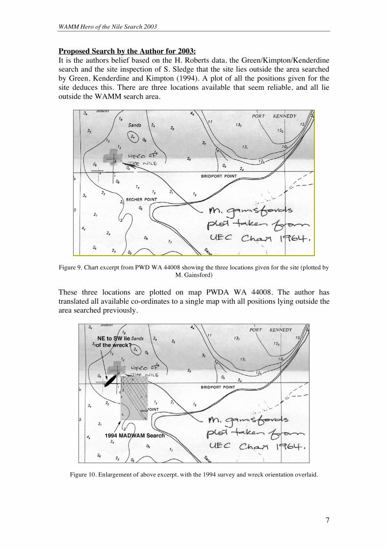
Proposed Search by the Author for 2003: It is the authors belief based on the H. Roberts data, the Green/Kimpton/Kenderdine search and the site inspection of S. Sledge that the site lies outside the area searched by Green, Kenderdine and Kimpton (1994). A plot of all the positions given for the site deduces this. There are three locations available that seem reliable, and all lie outside the WAMM search area.
Figure 9. Chart excerpt from PWD WA 44008 showing the three locations given for the site (plotted by
M. Gainsford) These three locations are plotted on map PWDA WA 44008. The author has translated all available co-ordinates to a single map with all positions lying outside the area searched previously.
Figure 10. Enlargement of above excerpt, with the 1994 survey and wreck orientation overlaid.

WAMM Hero of the Nile Search 2003
8
It appears that the search was not far enough to the north-west and just missed the wreck. A new search area will be determined to relocate the wreck combining a selection of search methods (to cover all bases) so that there can be an overlap in techniques. All techniques for searching have their flaws but with a stringent search method and combination of techniques the WAMM should relocate the site. The site is reanalysed above, as being mainly covered with sand, the only section of the site that can therefore greatly help us is the iron deck knees, which lie proud of the seabed (‘two rows of heavily overgrown outcroppings, proved to be iron’ Sledge, 1974 WAMM Inspection). There should be approximately ten of these, weighing each ca. 100 kilograms. An approximate size would be around three metres long and spaced about two metres apart. The site is estimated to be around 20-25 metres long and 5 metres wide, which means the amount of remaining iron and water depth will determine the search methods utilised and how effectively they perform their task.
Figure 11. How the process of disintegration may have occurred (After McCarthy) The methods used, as stated above, will be varied in order to conduct a methodical search and not a cursory search. A combination of magnetometer, side-scan sonar and diver tows will be utilised to better cover the search area enabling the searchers to look for submerged remains, offer a relief of the seabed and the use of the magnetometer to detect magnetic anomalies. In conjunction with a stringent search plan, the historical data can also aid its relocation. It was known to be travelling in a north-westerly direction when it stuck Long Point. Currents in the area (unbeknownst to the captain) were driving the vessel shoreward. It is these currents; direction of travel and the way a shipwreck behaves when it strikes land that offer us an insight into location and orientation. The vessel it appears struck land and has possibly swung around to follow the orientation of the reef (sandbank) to a north-east/south-west direction in two to three metres of water. These sandbanks are in a constant state of flux and the location of the sandbank today does not entirely reflect what it was like previously.

WAMM Hero of the Nile Search 2003
9
Figure 12. Diagram showing how the Hero of the Nile deck knees could lie (After McCarthy)
A précis of the search methods, area, layout and time frame of the search are outlined by the writer below. Methods for the 2003 Search: Remote sensing equipment that will be utilised as part of the survey process are, a
magnetometer of marine proton precession type, Elsec model 7706, manufactured by
Littlemore Scientific Engineering of Oxford in the United Kingdom and a side scan
sonar, manufactured in Gloucester by Marine Sonic Limited, that operates through
frequencies 150-600 kHz (kHz = thousand Hertz). Both the side scan sonar and
magnetometer will be used as per previous Museum surveys. There is a proven set up
and method that will be followed so that results can be standardised. They will be run
in tandem and in conjunction with a GPS (in WGS 84). This allows the software to
detect the, seabed or shipwreck relief, a magnetic trace (to detect anomalies) and a
position on the earths surface for reference to both the location of the WAMM vessel
and the wreck (if found).
Manual searches will be used in association with remote sensing. Seaspray will be utilised to tow up to three divers behind the vessel to sweep the seabed for anything unusual. There can be up to three divers towed by the boats outrigger system; they will utilise snorkelling gear with an even space between them and a total spread of ten metres. Since the water is shallow in the area to be searched this diver tow allows an extra dimension to the search as divers can be towed either side of, or the middle of Seaspray. Search Area for the 2003 Survey: After investigation into the location of the wreck ‘Hero of the Nile’ the author has decided upon a new search area to locate the site. This search area is both based on the co-ordinates found from charts, the WAMM file, Kenderdine 1995 and the previous 1994 survey, which did not locate the site. There is no accurate GPS for the site. The previous survey in 1994 failed to locate the site. It is the writers’ opinion that the shipwreck site ‘Hero of the Nile’ lies just outside the area searched. This allows for a search area to be developed that is realistic with a positive outlook for relocating the wreck site.

WAMM Hero of the Nile Search 2003
10
Chart: P.W.D.A W.A. 44008 New search (2003) bounded by area: 32° 21.800’ S to 32° 22.100’ S 115° 42.050’ E to 115° 42.550’ E or 32° 21’ 48’’ S to 32°22’ 6’’ S 115° 42’ 3’’ E to 115° 42’ 33’’ E This search area is just the beginning. The main impact on the survey results is the orientation of the vessel. As stated above the vessel lies in a north-east to south-west direction. This orientation allows us to determine in what direction we will run our search. The best possible chance of finding it is if we run a search perpendicular to the site, whereby we have 25 metres in which to cross the site. Therefore the search will run in a south-east to north-west direction, which should allow us hopefully to cross the site at 90°. Once this is established there needs to be a decision on the lane spacing for the search. Since the water is so shallow this does not allow for very wide spacing in the lanes. The lane spacing will be determined by the magnetometer. There is a formula that determines the lane spacing D3=104xW (where D = distance of object from the magnetometer and W = weight of the iron object). In this situation: D3=104x100 (where each deck knee is ca. 100 kg) D3=10 000x100 D=3 1 000 000 D=100 metres (this will be less as the water is so shallow) Since the water is so shallow the magnetometer and side scan sonar would operate better with closer lane spacings. These spacings are designed to cope with the size area and to cover the area as quickly and as accurately as possible. Therefore in this situation the lane spacing that would be recommended is ca.50 metres that allows for overlap (ca. 25 metres) in the survey both from the diver tows and the remote sensing equipment. Time Requirement for the 2003 Survey: The search area set up is of area approximately 600 metres by 750 metres. Since we will be searching in a north-west to south east pattern the length of search will be based upon the hypotenuse of the rectangular search area, which is 960.47 metres. If we were to travel an east-west course at 1.5 m.s-1 (5.4 km.h-1) with a lane spacing of 50m and an overlap of 25m each time then the survey would take approximately 3.5 to 4 hours for each type of search conducted to cover the entire area. However we are searching in a north-west to south east direction but the area is still the same. There could allowances for more time due to the more complex search structure but it should remain about the same timeframe. This does not include travel to and from the site or time required, to set up the systems for the search.

WAMM Hero of the Nile Search 2003
11
Conclusion: The wreck Hero of the Nile is located ca. 300 metres off Becher Point (Long Point) at an approximate bearing of 315°. It lies in a sandbank with the site being mostly covered (with sand) and only the iron deck knees lying proud of the seabed. Harold Roberts and company located the site in 1960. They were members of the Underwater Explorers Club and they both located the site and surveyed it. Since this time the Musuem has revisited the site once in 1974 by Scott Sledge and company. The sites location is contentious, as it has not been relocated since Sledge in 1974. A WAMM magnetometer survey in 1994 did not reveal the wrecks location, and it has been evidenced above that the search area set was just outside the wrecks location. Evidence gained from the previous surveys, historical accounts and search data have all indicated that the wreck lies further off shore than previously thought. All given locations lie outside the area searched in 1994 therefore a new search plan has been formulated above. This will utilise the information provided, combined with a magnetometer, side scan and diver tow survey. The new survey will encompass an area outside of that already searched. This will be bounded by the area (32° 21.800’ S to 32° 22.100’ S, 115° 42.050’ E to 115° 42.550’ E) and (32° 21’ 48’’ S to 32°22’ 6’’ S, 115° 42’ 3’’ E to 115° 42’ 33’’ E) Once the wreck is located it can then be assessed, surveyed and its location recorded via new transits and a GPS position that should allow the subsequent reinvestigation of the site in the future.
Figure 13. Chart excerpt from WA 913 showing the new search area plot for the 2003 search for the Hero of the Nile (M. Gainsford)

WAMM Hero of the Nile Search 2003
12
Appendix A: Maps and Site Plans for the Hero of the Nile. Map 1. BA 1058 (Excerpt), UEC Chart: a Guide to Wrecks in the Fremantle Area. Map 2.PWD WA 44008 (Excerpt): Showing the Three Locations Given. Map 3.PWD WA 44008 (Excerpt): Area for WAMM’s 1994 Magnetometer Survey. Map 4. WA 913 (Excerpt): Chart of the Warnbro Area. Site Plan 1. H. Roberts: Wreck off Long Point (Hero of the Nile) Site Plan 2. Hero of the Nile: Unknown, Possibly S. Sledge

WAMM Hero of the Nile Search 2003
13
Appendix B: Other Authors Work. A. Harold Roberts Hero of the Nile Report B. Conservation Report on the Bell Fragment C. Hero of the Nile Bell Record, Museum Artefact Database D. Photos of the Hero of the Nile bell (M. Gainsford) E. Scott Sledge Wreck Report F. Sarah Kenderdine Excerpt G. Graham Henderson Excerpt

WAMM Hero of the Nile Search 2003
14
Sources: Henderson, G. & Henderson, K.J., 1988, Unfinished Voyages: Western Australian Shipwrecks 1851-1880. University of Western Australia Press, Nedlands, Western Australia. Kenderdine, S., 1995, Shipwrecks 1652-1942: a guide to historic wreck sites of Perth. Western Australian Maritime Museum, Fremantle, Australia. McCarthy, M., 1979, Jervoise Bay Shipwrecks. Department of Maritime Archaeology, Western Australian Museum, Perth. McCarthy, M., 2003, pers. comm. Roberts, H., 1966, The Hero of the Nile Report. Report Located in WAMM File No. 431/71. WAMM File No. 431/71