north dakota department of transportation 83 study sia... · north dakota department of...
TRANSCRIPT

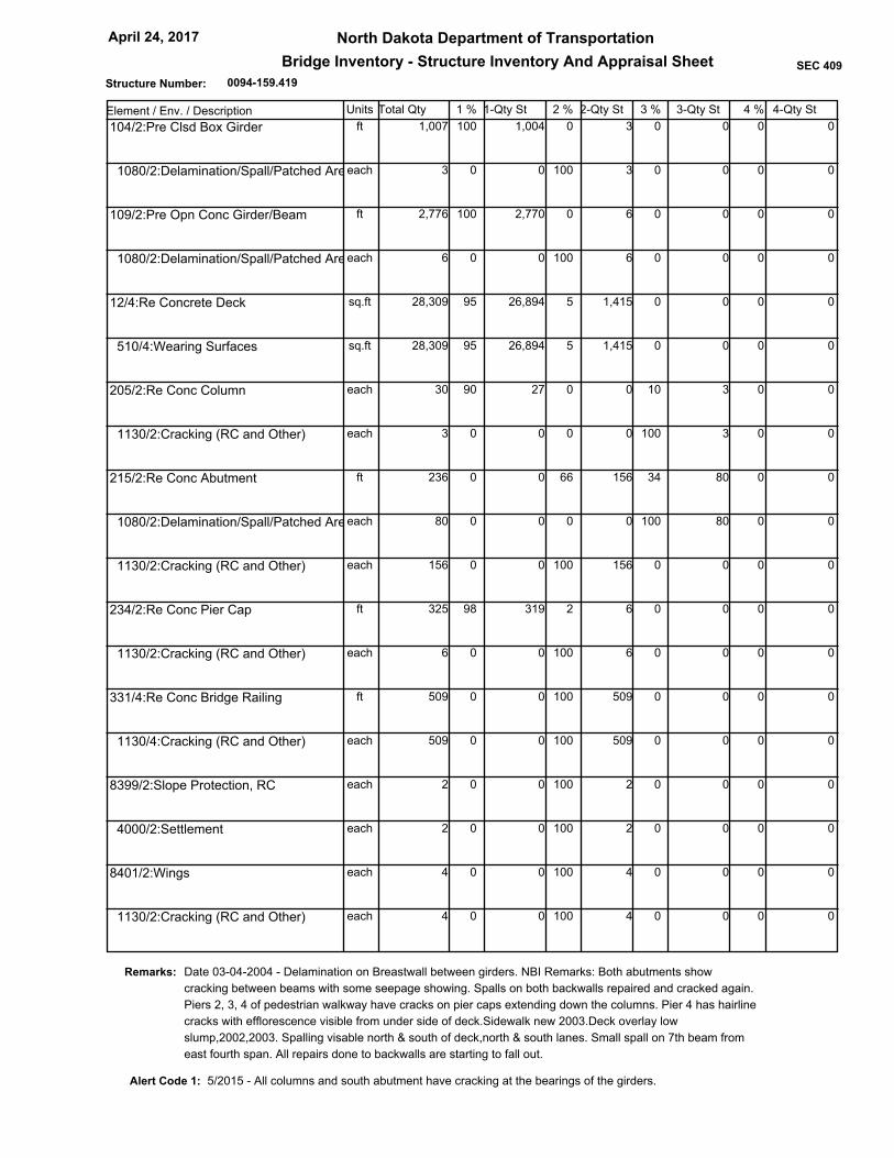
0094-159.419
North Dakota Department of Transportation
Bridge Inventory - Structure Inventory And Appraisal Sheet
April 24, 2017
SEC 409
Structure Number:
Bismarck District02 Highway District
Burleigh03 County
00083
I-94/STATE STREET INT06 Feats Intersect
JUNCTION OF US 83N & I-9409 Location
10 Miles
Route On Structure
2 U.S. Numbered Hwy1 Mainline 0 N/A (NBI)
05 Inventory Route
Not applicable
26 Functional Urban, Other Principal Arterial
27 Yr Built 106 Yr Reconstructed
28 Lanes on Structure
29 ADT 30 Year of ADT
31 Design Load
32 Approach Roadway Width
34 Skew
36 Traffic Safety Features
41 Structure Open, Closed or Posted
42 Type of Service
43 Main Struct Type
45 No. Spans in Main Unit
46 No. Approach Spans
47 Total Horizontal Clearance
48 Length of Max Span
49 Structure Length
50 Curb/Sidewalk Widths
51 Bridge Rdwy Width - Curb to Curb
52 Deck Width
53 Min Vert Clear. Over Bridge
54 Min Vert Underclearance
55 Min Lateral UnderClear. - Rt
56 Min Lateral UnderClear. - Lt
107 Deck Struct Type
108 Wearing Surface
Membrane
Dk Protect
208 Dk Overburden
58 Deck
59 Superstructure60 Substructure
61 Chan. & Chan. Protection
62 Culvert and Retaining Walls
64 Oper. Rating
66 Inv. Rating
67 Structural Condition
68 Deck Geometry
70 Bridge Posting
209 Posted in "Tons"
71 Waterway Adequacy
72 App. Rdwy. Alignment
90 Date of Last Inspection
92 Critical Feature Inspected / 93 Critical Feature Last Inpsection Dt
218 Channel Profile
113 Scour Critical
214 Delayed Inspection
210 Culvert / 211 Description
200 System Designation
201 Status
202 Sufficiency Rating
207 Transporter Erector Routes and Sites
216 Inspector
1965 1980
4
27,600 2014
MS 18 (HS 20) (live load for which structure was designated)
0.00
1 11 1
A Open, no restriction
Prestressed conc cont
Stringer
4
0
51.8 Ft.
69 Ft.
254.92 Ft.
0.0 Ft Lt-Side
8.2 Ft Rt-Side
110.9 Ft.
110.9 Ft.
H Hwy beneath struct
H Hwy beneath struct
28.5 Ft.
1 Concrete-Cast-in-Place
4 Low Slump Concrete
0 None
None
None
7 Good
7 Good7 Good
N N/A (NBI)
N N/A (NBI)
N Not applicable
7 Above Min Criteria
9 Above Desirable Crit
5 At/Above Legal Loads
00 Tons
8 Equal Desirable Crit
May 20, 2015
Fracture Critical
Underwater
Other Special
N
N
N
N
N Not Over Waterway
Not Applicable
Not Deficient
-1
85.00
1 - State
Kerzman Jochim
81 Tons
49 Tons
6 2d level interchg - On
1 Highway - Under
01 State Highway Agency22 Owner
1 LF Load Factor
1 LF Load Factor
HS 45
HS 27
Identification
04 City BISMARCK CITY
88.97911 Milepoint
13 LRS Inv Route. Subroute 0000000000 00
16 Latitude
17 Longitude
_
98 Border Bridge
99 Border Bridge Struct No.
0.00 %
Structure Type and Material
Classification
Unknown (P)
37 Historical Significance 3 Possibly eligible for
21 Maint Responsibility
20 Toll
12 Base Highway Network On Base Network
3 On free road
01 State Highway Agency
100 Defense Highway Designation
101 Parallel Structure Designation
102 Direction of Traffic
103 Temporary Structure Designation
104 Highway System of Inventory Rte
105 Federal Lands Highways
110 Designated National Network
112 NBIS Bridge Length
3 STRAHNET Connector
No || bridge exists
Not Applicable (P)
1 On the NHS
1 Part of natl network
2 2-way traffic
Condition
44 Approach Struct Type Unknown (NBI)
Unknown (P)
Age and Service
Load Rating and Posting
3.00109 Average Daily Truck Traffic
63 Operating Rating Method
65 Inventory Rating Method
Appraisal
6 Equal Minimum69 Underclear. Vert & Horiz
Geometric Data
10 Min Vert Clearance
33 Bridge Median 0 No median
35 Structure Flared 0 No flare
Inspections
91 Designated Inspection Frequency 24 Months
I-1-094(04)156213 Federal Aid Project Number
11/17/2016212 Structure Load Rated
Navigation Data
38 Navigation Control
39 Navigation Vertical Clearance
40 Navigation Horizontal Clearance
111 Pier or Abutment Protection
116 Minimum Navigation Vertical Clearance
NA-no waterway
Unknown (NBI)
0 Ft.
0 Ft.
Ft.
15.1 Ft.
52 Ft.
364787.1 5187954.7GPS Coordinates XY
46d 49' 53.00"
100d 46' 23.00"
99 Ft. 12 In.
99 Ft. 12 In.
16 Ft. 8 In.
1
Chaining Date None
19 Bypass, Detour Length
Yes
0094-159.419
North Dakota Department of Transportation
Bridge Inventory - Structure Inventory And Appraisal Sheet
April 24, 2017
SEC 409
Structure Number:
Element / Env. / Description Units Total Qty 1-Qty St 2-Qty St 3-Qty St1 % 2 % 3 % 4 % 4-Qty St
3 0 0 0 0 100 1,004 1,007ft 0 104/2:Pre Clsd Box Girder
3 100 0 0 0 0 0 3each 0 1080/2:Delamination/Spall/Patched Area
6 0 0 0 0 100 2,770 2,776ft 0 109/2:Pre Opn Conc Girder/Beam
6 100 0 0 0 0 0 6each 0 1080/2:Delamination/Spall/Patched Area
1,415 5 0 0 0 95 26,894 28,309sq.ft 0 12/4:Re Concrete Deck
1,415 5 0 0 0 95 26,894 28,309sq.ft 0 510/4:Wearing Surfaces
0 0 10 3 0 90 27 30each 0 205/2:Re Conc Column
0 0 100 3 0 0 0 3each 0 1130/2:Cracking (RC and Other)
156 66 34 80 0 0 0 236ft 0 215/2:Re Conc Abutment
0 0 100 80 0 0 0 80each 0 1080/2:Delamination/Spall/Patched Area
156 100 0 0 0 0 0 156each 0 1130/2:Cracking (RC and Other)
6 2 0 0 0 98 319 325ft 0 234/2:Re Conc Pier Cap
6 100 0 0 0 0 0 6each 0 1130/2:Cracking (RC and Other)
509 100 0 0 0 0 0 509ft 0 331/4:Re Conc Bridge Railing
509 100 0 0 0 0 0 509each 0 1130/4:Cracking (RC and Other)
2 100 0 0 0 0 0 2each 0 8399/2:Slope Protection, RC
2 100 0 0 0 0 0 2each 0 4000/2:Settlement
4 100 0 0 0 0 0 4each 0 8401/2:Wings
4 100 0 0 0 0 0 4each 0 1130/2:Cracking (RC and Other)
Date 03-04-2004 - Delamination on Breastwall between girders. NBI Remarks: Both abutments show
cracking between beams with some seepage showing. Spalls on both backwalls repaired and cracked again.
Piers 2, 3, 4 of pedestrian walkway have cracks on pier caps extending down the columns. Pier 4 has hairline
cracks with efflorescence visible from under side of deck.Sidewalk new 2003.Deck overlay low
slump,2002,2003. Spalling visable north & south of deck,north & south lanes. Small spall on 7th beam from
east fourth span. All repairs done to backwalls are starting to fall out.
Remarks:
Alert Code 1: 5/2015 - All columns and south abutment have cracking at the bearings of the girders.

0094-159.926
North Dakota Department of Transportation
Bridge Inventory - Structure Inventory And Appraisal Sheet
April 24, 2017
SEC 409
Structure Number:
Bismarck District02 Highway District
Burleigh03 County
00000
I-94/19TH STREET SEP06 Feats Intersect
1 EAST OF US 83 NORTH09 Location
2 Miles
Route On Structure
5 City Street 1 Mainline 0 N/A (NBI)
05 Inventory Route
Not applicable
26 Functional Urban, Collector
27 Yr Built 106 Yr Reconstructed
28 Lanes on Structure
29 ADT 30 Year of ADT
31 Design Load
32 Approach Roadway Width
34 Skew
36 Traffic Safety Features
41 Structure Open, Closed or Posted
42 Type of Service
43 Main Struct Type
45 No. Spans in Main Unit
46 No. Approach Spans
47 Total Horizontal Clearance
48 Length of Max Span
49 Structure Length
50 Curb/Sidewalk Widths
51 Bridge Rdwy Width - Curb to Curb
52 Deck Width
53 Min Vert Clear. Over Bridge
54 Min Vert Underclearance
55 Min Lateral UnderClear. - Rt
56 Min Lateral UnderClear. - Lt
107 Deck Struct Type
108 Wearing Surface
Membrane
Dk Protect
208 Dk Overburden
58 Deck
59 Superstructure60 Substructure
61 Chan. & Chan. Protection
62 Culvert and Retaining Walls
64 Oper. Rating
66 Inv. Rating
67 Structural Condition
68 Deck Geometry
70 Bridge Posting
209 Posted in "Tons"
71 Waterway Adequacy
72 App. Rdwy. Alignment
90 Date of Last Inspection
92 Critical Feature Inspected / 93 Critical Feature Last Inpsection Dt
218 Channel Profile
113 Scour Critical
214 Delayed Inspection
210 Culvert / 211 Description
200 System Designation
201 Status
202 Sufficiency Rating
207 Transporter Erector Routes and Sites
216 Inspector
1976 -1
2
7,300 2014
M 18 (H 20) (live load for which structure was designated)
0.00
0 11 1
A Open, no restriction
Steel continuous
Stringer
4
0
47.9 Ft.
109 Ft.
225.07 Ft.
0.0 Ft Lt-Side
8.2 Ft Rt-Side
48.2 Ft.
61.4 Ft.
H Hwy beneath struct
H Hwy beneath struct
28.2 Ft.
1 Concrete-Cast-in-Place
1 Monolithic Concrete
0 None
None
None
7 Good
7 Good7 Good
N N/A (NBI)
N N/A (NBI)
N Not applicable
7 Above Min Criteria
9 Above Desirable Crit
5 At/Above Legal Loads
00 Tons
8 Equal Desirable Crit
May 20, 2015
Fracture Critical
Underwater
Other Special
N
N
N
N
N Not Over Waterway
Not Applicable
Not Deficient
-1
98.80
1 - State
Kerzman
58 Tons
35 Tons
5 Highway-pedestrian - On
1 Highway - Under
01 State Highway Agency22 Owner
1 LF Load Factor
1 LF Load Factor
HS 32
HS 19
Identification
04 City BISMARCK CITY
0.00011 Milepoint
13 LRS Inv Route. Subroute
16 Latitude
17 Longitude
_
98 Border Bridge
99 Border Bridge Struct No.
0.00 %
Structure Type and Material
Classification
Unknown (P)
37 Historical Significance 5 Not eligible for NRHP
21 Maint Responsibility
20 Toll
12 Base Highway Network Not on Base Network
3 On free road
01 State Highway Agency
100 Defense Highway Designation
101 Parallel Structure Designation
102 Direction of Traffic
103 Temporary Structure Designation
104 Highway System of Inventory Rte
105 Federal Lands Highways
110 Designated National Network
112 NBIS Bridge Length
0 Not a STRAHNET hwy
No || bridge exists
Not Applicable (P)
0 Not on NHS
0 Not part of natl netwo
2 2-way traffic
Condition
44 Approach Struct Type Unknown (NBI)
Unknown (P)
Age and Service
Load Rating and Posting
3.00109 Average Daily Truck Traffic
63 Operating Rating Method
65 Inventory Rating Method
Appraisal
6 Equal Minimum69 Underclear. Vert & Horiz
Geometric Data
10 Min Vert Clearance
33 Bridge Median 0 No median
35 Structure Flared 0 No flare
Inspections
91 Designated Inspection Frequency 24 Months
I-1-094(30)160213 Federal Aid Project Number
11/17/2016212 Structure Load Rated
Navigation Data
38 Navigation Control
39 Navigation Vertical Clearance
40 Navigation Horizontal Clearance
111 Pier or Abutment Protection
116 Minimum Navigation Vertical Clearance
NA-no waterway
Unknown (NBI)
0 Ft.
0 Ft.
Ft.
17.1 Ft.
48 Ft.
365595.6 5187936.3GPS Coordinates XY
46d 49' 54.00"
100d 45' 42.00"
99 Ft. 12 In.
99 Ft. 12 In.
16 Ft. 8 In.
1
Chaining Date None
19 Bypass, Detour Length
Yes

0094-159.926
North Dakota Department of Transportation
Bridge Inventory - Structure Inventory And Appraisal Sheet
April 24, 2017
SEC 409
Structure Number:
Element / Env. / Description Units Total Qty 1-Qty St 2-Qty St 3-Qty St1 % 2 % 3 % 4 % 4-Qty St
0 0 0 0 0 100 1,575 1,575ft 0 107/2:Steel Opn Girder/Beam
0 0 0 0 0 100 17,150 17,150sq.ft 0 515/2:Steel Protective Coating
692 5 0 0 0 95 13,150 13,842sq.ft 0 12/4:Re Concrete Deck
692 100 0 0 0 0 0 692each 0 1130/4:Cracking (RC and Other)
0 0 0 0 0 100 4 4each 0 205/2:Re Conc Column
0 0 2 3 0 98 118 121ft 0 215/2:Re Conc Abutment
0 0 100 3 0 0 0 3each 0 1130/2:Cracking (RC and Other)
0 0 0 0 0 100 56 56ft 0 234/2:Re Conc Pier Cap
0 0 0 0 0 100 14 14each 0 311/2:Moveable Bearing
0 0 0 0 0 100 100 100sq.ft 0 515/2:Steel Protective Coating
0 0 0 0 0 100 14 14each 0 313/2:Fixed Bearing
0 0 0 0 0 100 100 100sq.ft 0 515/2:Steel Protective Coating
449 100 0 0 0 0 0 449ft 0 331/4:Re Conc Bridge Railing
449 100 0 0 0 0 0 449each 0 1130/4:Cracking (RC and Other)
2 100 0 0 0 0 0 2each 0 8399/2:Slope Protection, RC
2 100 0 0 0 0 0 2each 0 4000/2:Settlement
0 0 0 0 0 100 4 4each 0 8401/2:Wings
NBI Remarks: Some fine shrinkage cracks visible from under structure in deck and sidewalk area. Fine
diagonal crack in all four corners of backwalls. Minor cracking and seepage in north backwall. Some
shrinkage cracks in curbs and deck. Cracking and minor spalling in curb. North slope protection pulled away
from backwall 4" & the south 5". Outside of exterior beams have been repainted. Some rust spots on all beam
flanges. Vehicle damage to west beam, eastbound bottom flange. Not serious. The west beam of westbound
now has the flange hit a hydraulic hose apparently hit and broke, oil on webs of west beam and w1.
01/13/2014 - North slope protection pulled away from abutment 6".
Remarks:

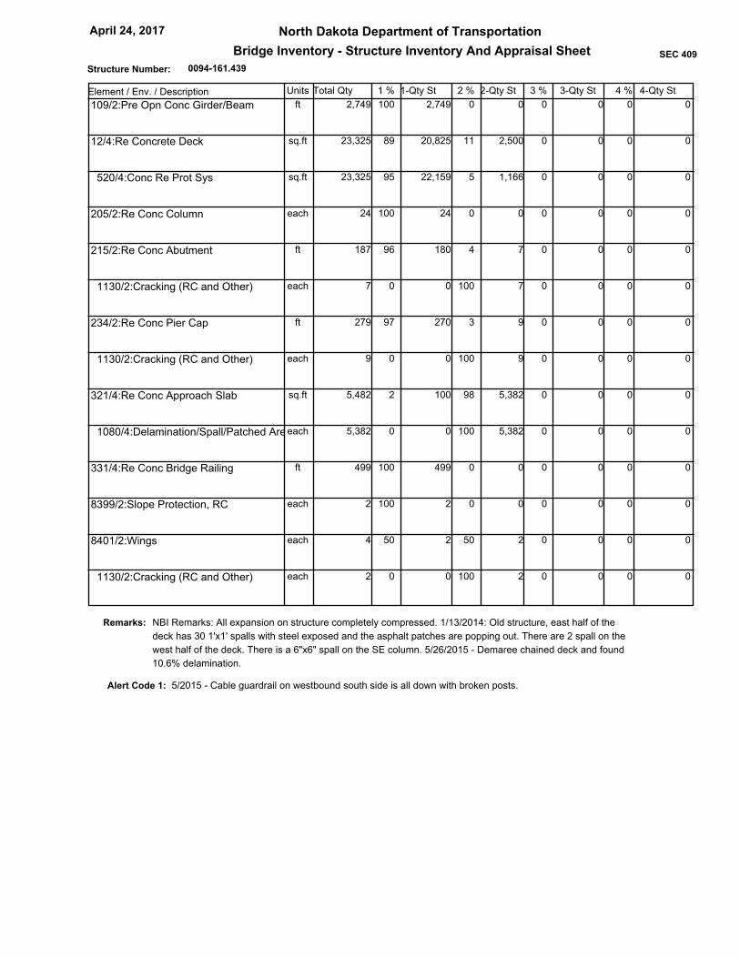
0094-161.439
North Dakota Department of Transportation
Bridge Inventory - Structure Inventory And Appraisal Sheet
April 24, 2017
SEC 409
Structure Number:
Bismarck District02 Highway District
Burleigh03 County
00094
I-94/EAST BISMARCK INT06 Feats Intersect
2 EAST OF US 83 NORTH09 Location
4 Miles
Route On Structure
3 State Hwy 1 Mainline 0 N/A (NBI)
05 Inventory Route
Not applicable
26 Functional Urban, Other Principal Arterial
27 Yr Built 106 Yr Reconstructed
28 Lanes on Structure
29 ADT 30 Year of ADT
31 Design Load
32 Approach Roadway Width
34 Skew
36 Traffic Safety Features
41 Structure Open, Closed or Posted
42 Type of Service
43 Main Struct Type
45 No. Spans in Main Unit
46 No. Approach Spans
47 Total Horizontal Clearance
48 Length of Max Span
49 Structure Length
50 Curb/Sidewalk Widths
51 Bridge Rdwy Width - Curb to Curb
52 Deck Width
53 Min Vert Clear. Over Bridge
54 Min Vert Underclearance
55 Min Lateral UnderClear. - Rt
56 Min Lateral UnderClear. - Lt
107 Deck Struct Type
108 Wearing Surface
Membrane
Dk Protect
208 Dk Overburden
58 Deck
59 Superstructure60 Substructure
61 Chan. & Chan. Protection
62 Culvert and Retaining Walls
64 Oper. Rating
66 Inv. Rating
67 Structural Condition
68 Deck Geometry
70 Bridge Posting
209 Posted in "Tons"
71 Waterway Adequacy
72 App. Rdwy. Alignment
90 Date of Last Inspection
92 Critical Feature Inspected / 93 Critical Feature Last Inpsection Dt
218 Channel Profile
113 Scour Critical
214 Delayed Inspection
210 Culvert / 211 Description
200 System Designation
201 Status
202 Sufficiency Rating
207 Transporter Erector Routes and Sites
216 Inspector
1964 1995
5
11,000 2014
MS 22.5 (HS 25) (live load for which structure was designed)
0.00
1 11 1
A Open, no restriction
Prestressed conc cont
Stringer
4
0
44.0 Ft.
65 Ft.
250.00 Ft.
0.0 Ft Lt-Side
9.8 Ft Rt-Side
77.4 Ft.
93.2 Ft.
H Hwy beneath struct
H Hwy beneath struct
28.5 Ft.
1 Concrete-Cast-in-Place
1 Monolithic Concrete
0 None
1 Epoxy Coated Reinforci
None
7 Good
9 Excellent7 Good
N N/A (NBI)
N N/A (NBI)
N Not applicable
7 Above Min Criteria
7 Above Min Criteria
5 At/Above Legal Loads
00 Tons
8 Equal Desirable Crit
May 26, 2015
Fracture Critical
Underwater
Other Special
N
N
N
N
N Not Over Waterway
Not Applicable
Not Deficient
-1
96.90
1 - State
Kerzman Jochim Sanborn
86 Tons
52 Tons
6 2d level interchg - On
1 Highway - Under
01 State Highway Agency22 Owner
1 LF Load Factor
1 LF Load Factor
HS 47
HS 28
Identification
04 City BISMARCK CITY
926.66911 Milepoint
13 LRS Inv Route. Subroute 0000000000 00
16 Latitude
17 Longitude
_
98 Border Bridge
99 Border Bridge Struct No.
0.00 %
Structure Type and Material
Classification
Unknown (P)
37 Historical Significance 3 Possibly eligible for
21 Maint Responsibility
20 Toll
12 Base Highway Network On Base Network
3 On free road
01 State Highway Agency
100 Defense Highway Designation
101 Parallel Structure Designation
102 Direction of Traffic
103 Temporary Structure Designation
104 Highway System of Inventory Rte
105 Federal Lands Highways
110 Designated National Network
112 NBIS Bridge Length
0 Not a STRAHNET hwy
No || bridge exists
Not Applicable (P)
1 On the NHS
0 Not part of natl netwo
2 2-way traffic
Condition
44 Approach Struct Type Unknown (NBI)
Unknown (P)
Age and Service
Load Rating and Posting
7.00109 Average Daily Truck Traffic
63 Operating Rating Method
65 Inventory Rating Method
Appraisal
6 Equal Minimum69 Underclear. Vert & Horiz
Geometric Data
10 Min Vert Clearance
33 Bridge Median 3 Closed Med w/Barriers
35 Structure Flared 0 No flare
Inspections
91 Designated Inspection Frequency 24 Months
IM-1-094(013)156213 Federal Aid Project Number
11/17/2016212 Structure Load Rated
Navigation Data
38 Navigation Control
39 Navigation Vertical Clearance
40 Navigation Horizontal Clearance
111 Pier or Abutment Protection
116 Minimum Navigation Vertical Clearance
NA-no waterway
Unknown (NBI)
0 Ft.
0 Ft.
Ft.
13.1 Ft.
72 Ft.
368029.3 5187879.2GPS Coordinates XY
46d 49' 54.00"
100d 43' 48.00"
99 Ft. 12 In.
99 Ft. 12 In.
16 Ft. 12 In.
1
Chaining Date 5/26/2015
19 Bypass, Detour Length
Yes
0094-161.439
North Dakota Department of Transportation
Bridge Inventory - Structure Inventory And Appraisal Sheet
April 24, 2017
SEC 409
Structure Number:
Element / Env. / Description Units Total Qty 1-Qty St 2-Qty St 3-Qty St1 % 2 % 3 % 4 % 4-Qty St
0 0 0 0 0 100 2,749 2,749ft 0 109/2:Pre Opn Conc Girder/Beam
2,500 11 0 0 0 89 20,825 23,325sq.ft 0 12/4:Re Concrete Deck
1,166 5 0 0 0 95 22,159 23,325sq.ft 0 520/4:Conc Re Prot Sys
0 0 0 0 0 100 24 24each 0 205/2:Re Conc Column
7 4 0 0 0 96 180 187ft 0 215/2:Re Conc Abutment
7 100 0 0 0 0 0 7each 0 1130/2:Cracking (RC and Other)
9 3 0 0 0 97 270 279ft 0 234/2:Re Conc Pier Cap
9 100 0 0 0 0 0 9each 0 1130/2:Cracking (RC and Other)
5,382 98 0 0 0 2 100 5,482sq.ft 0 321/4:Re Conc Approach Slab
5,382 100 0 0 0 0 0 5,382each 0 1080/4:Delamination/Spall/Patched Area
0 0 0 0 0 100 499 499ft 0 331/4:Re Conc Bridge Railing
0 0 0 0 0 100 2 2each 0 8399/2:Slope Protection, RC
2 50 0 0 0 50 2 4each 0 8401/2:Wings
2 100 0 0 0 0 0 2each 0 1130/2:Cracking (RC and Other)
NBI Remarks: All expansion on structure completely compressed. 1/13/2014: Old structure, east half of the
deck has 30 1'x1' spalls with steel exposed and the asphalt patches are popping out. There are 2 spall on the
west half of the deck. There is a 6"x6" spall on the SE column. 5/26/2015 - Demaree chained deck and found
10.6% delamination.
Remarks:
Alert Code 1: 5/2015 - Cable guardrail on westbound south side is all down with broken posts.

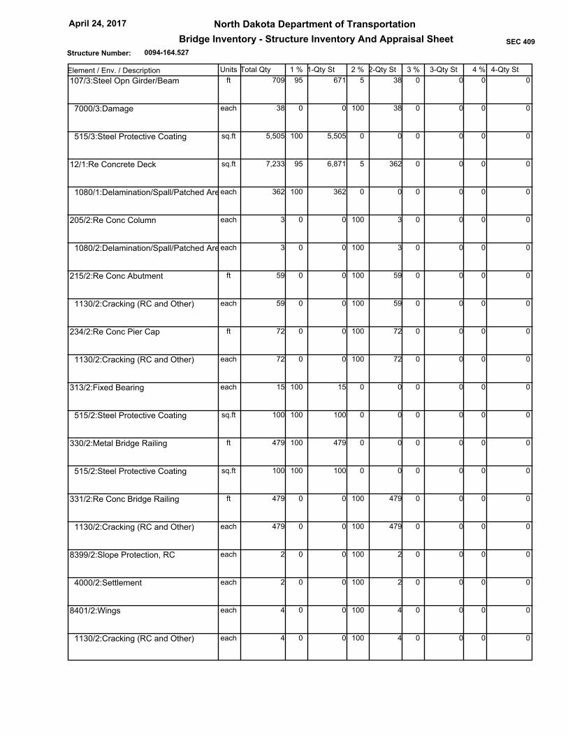
0094-164.527
North Dakota Department of Transportation
Bridge Inventory - Structure Inventory And Appraisal Sheet
April 24, 2017
SEC 409
Structure Number:
Bismarck District02 Highway District
Burleigh03 County
00000
GIBBS TWP SEPARATION06 Feats Intersect
5 EAST OF US 83 NORTH09 Location
10 Miles
Route On Structure
4 County Hwy 1 Mainline 0 N/A (NBI)
05 Inventory Route
Not applicable
26 Functional Rural, Local
27 Yr Built 106 Yr Reconstructed
28 Lanes on Structure
29 ADT 30 Year of ADT
31 Design Load
32 Approach Roadway Width
34 Skew
36 Traffic Safety Features
41 Structure Open, Closed or Posted
42 Type of Service
43 Main Struct Type
45 No. Spans in Main Unit
46 No. Approach Spans
47 Total Horizontal Clearance
48 Length of Max Span
49 Structure Length
50 Curb/Sidewalk Widths
51 Bridge Rdwy Width - Curb to Curb
52 Deck Width
53 Min Vert Clear. Over Bridge
54 Min Vert Underclearance
55 Min Lateral UnderClear. - Rt
56 Min Lateral UnderClear. - Lt
107 Deck Struct Type
108 Wearing Surface
Membrane
Dk Protect
208 Dk Overburden
58 Deck
59 Superstructure60 Substructure
61 Chan. & Chan. Protection
62 Culvert and Retaining Walls
64 Oper. Rating
66 Inv. Rating
67 Structural Condition
68 Deck Geometry
70 Bridge Posting
209 Posted in "Tons"
71 Waterway Adequacy
72 App. Rdwy. Alignment
90 Date of Last Inspection
92 Critical Feature Inspected / 93 Critical Feature Last Inpsection Dt
218 Channel Profile
113 Scour Critical
214 Delayed Inspection
210 Culvert / 211 Description
200 System Designation
201 Status
202 Sufficiency Rating
207 Transporter Erector Routes and Sites
216 Inspector
1965 -1
2
50 2014
M 13.5 (H 15) (live load for which structure was designated)
0.00
1 11 1
A Open, no restriction
Steel continuous
Stringer
4
0
24.0 Ft.
66 Ft.
241.14 Ft.
0.0 Ft Lt-Side
0.0 Ft Rt-Side
24.3 Ft.
29.9 Ft.
H Hwy beneath struct
H Hwy beneath struct
28.5 Ft.
1 Concrete-Cast-in-Place
1 Monolithic Concrete
0 None
None
None
6 Satisfactory
6 Satisfactory6 Satisfactory
N N/A (NBI)
N N/A (NBI)
N Not applicable
5 Above Min Tolerable
6 Equal Min Criteria
5 At/Above Legal Loads
00 Tons
8 Equal Desirable Crit
May 26, 2015
Fracture Critical
Underwater
Other Special
N
N
N
N
N Not Over Waterway
Not Applicable
Not Deficient
-1
83.50
1 - State
Kerzman Jochim Sanborn
36 Tons
22 Tons
1 Highway - On
1 Highway - Under
01 State Highway Agency22 Owner
1 LF Load Factor
1 LF Load Factor
HS 20
HS 12
Identification
04 City GIBBS TOWNSHIP
0.00011 Milepoint
13 LRS Inv Route. Subroute
16 Latitude
17 Longitude
_
98 Border Bridge
99 Border Bridge Struct No.
0.00 %
Structure Type and Material
Classification
Unknown (P)
37 Historical Significance 3 Possibly eligible for
21 Maint Responsibility
20 Toll
12 Base Highway Network Not on Base Network
3 On free road
01 State Highway Agency
100 Defense Highway Designation
101 Parallel Structure Designation
102 Direction of Traffic
103 Temporary Structure Designation
104 Highway System of Inventory Rte
105 Federal Lands Highways
110 Designated National Network
112 NBIS Bridge Length
0 Not a STRAHNET hwy
No || bridge exists
Not Applicable (P)
0 Not on NHS
0 Not part of natl netwo
2 2-way traffic
Condition
44 Approach Struct Type Unknown (NBI)
Unknown (P)
Age and Service
Load Rating and Posting
109 Average Daily Truck Traffic
63 Operating Rating Method
65 Inventory Rating Method
Appraisal
5 Above Tolerable69 Underclear. Vert & Horiz
Geometric Data
10 Min Vert Clearance
33 Bridge Median 0 No median
35 Structure Flared 0 No flare
Inspections
91 Designated Inspection Frequency 24 Months
I-1-094(10)163213 Federal Aid Project Number
03/08/2016212 Structure Load Rated
Navigation Data
38 Navigation Control
39 Navigation Vertical Clearance
40 Navigation Horizontal Clearance
111 Pier or Abutment Protection
116 Minimum Navigation Vertical Clearance
NA-no waterway
Unknown (NBI)
0 Ft.
0 Ft.
Ft.
13.1 Ft.
26 Ft.
372850.5 5188575.4GPS Coordinates XY
46d 50' 19.00"
100d 40' 03.00"
99 Ft. 12 In.
99 Ft. 12 In.
16 Ft. 1 In.
1
Chaining Date None
19 Bypass, Detour Length
Yes
0094-164.527
North Dakota Department of Transportation
Bridge Inventory - Structure Inventory And Appraisal Sheet
April 24, 2017
SEC 409
Structure Number:
Element / Env. / Description Units Total Qty 1-Qty St 2-Qty St 3-Qty St1 % 2 % 3 % 4 % 4-Qty St
38 5 0 0 0 95 671 709ft 0 107/3:Steel Opn Girder/Beam
38 100 0 0 0 0 0 38each 0 7000/3:Damage
0 0 0 0 0 100 5,505 5,505sq.ft 0 515/3:Steel Protective Coating
362 5 0 0 0 95 6,871 7,233sq.ft 0 12/1:Re Concrete Deck
0 0 0 0 0 100 362 362each 0 1080/1:Delamination/Spall/Patched Area
3 100 0 0 0 0 0 3each 0 205/2:Re Conc Column
3 100 0 0 0 0 0 3each 0 1080/2:Delamination/Spall/Patched Area
59 100 0 0 0 0 0 59ft 0 215/2:Re Conc Abutment
59 100 0 0 0 0 0 59each 0 1130/2:Cracking (RC and Other)
72 100 0 0 0 0 0 72ft 0 234/2:Re Conc Pier Cap
72 100 0 0 0 0 0 72each 0 1130/2:Cracking (RC and Other)
0 0 0 0 0 100 15 15each 0 313/2:Fixed Bearing
0 0 0 0 0 100 100 100sq.ft 0 515/2:Steel Protective Coating
0 0 0 0 0 100 479 479ft 0 330/2:Metal Bridge Railing
0 0 0 0 0 100 100 100sq.ft 0 515/2:Steel Protective Coating
479 100 0 0 0 0 0 479ft 0 331/2:Re Conc Bridge Railing
479 100 0 0 0 0 0 479each 0 1130/2:Cracking (RC and Other)
2 100 0 0 0 0 0 2each 0 8399/2:Slope Protection, RC
2 100 0 0 0 0 0 2each 0 4000/2:Settlement
4 100 0 0 0 0 0 4each 0 8401/2:Wings
4 100 0 0 0 0 0 4each 0 1130/2:Cracking (RC and Other)
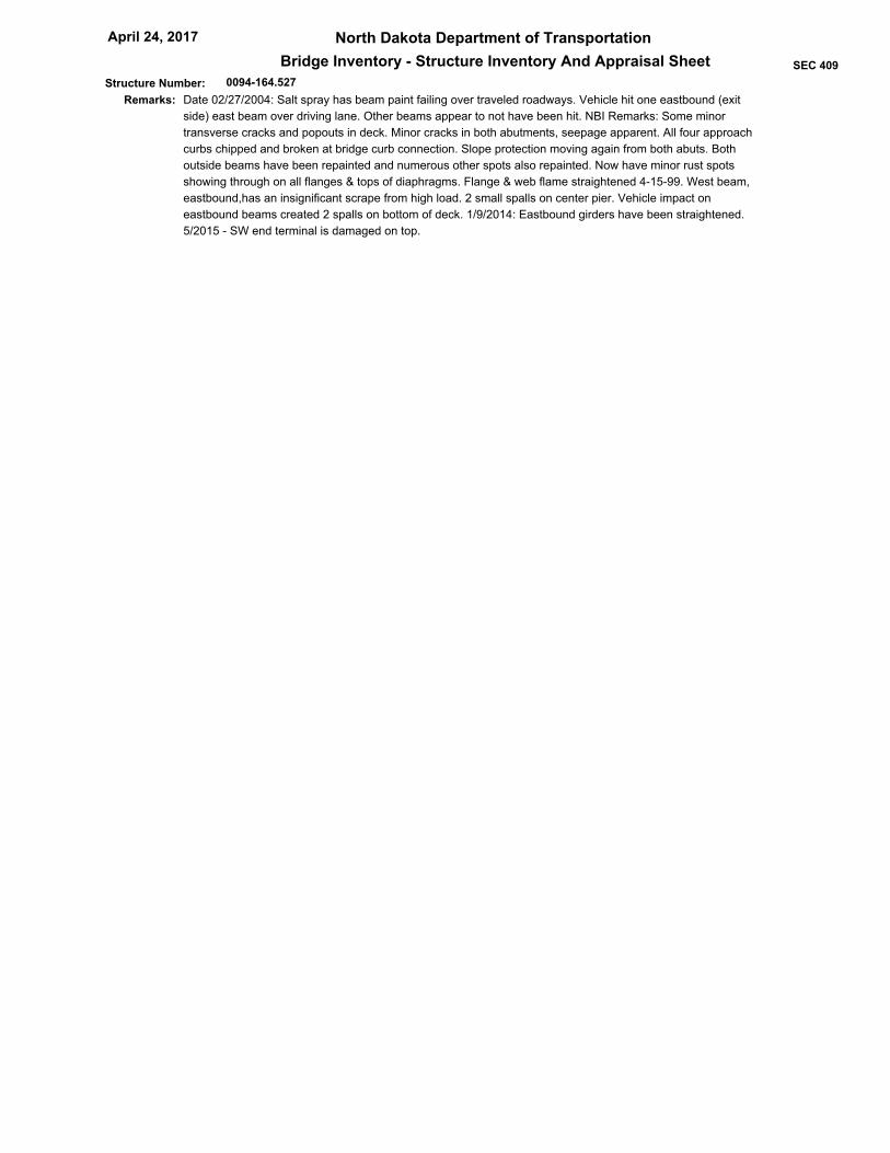
0094-164.527
North Dakota Department of Transportation
Bridge Inventory - Structure Inventory And Appraisal Sheet
April 24, 2017
SEC 409
Structure Number:
Date 02/27/2004: Salt spray has beam paint failing over traveled roadways. Vehicle hit one eastbound (exit
side) east beam over driving lane. Other beams appear to not have been hit. NBI Remarks: Some minor
transverse cracks and popouts in deck. Minor cracks in both abutments, seepage apparent. All four approach
curbs chipped and broken at bridge curb connection. Slope protection moving again from both abuts. Both
outside beams have been repainted and numerous other spots also repainted. Now have minor rust spots
showing through on all flanges & tops of diaphragms. Flange & web flame straightened 4-15-99. West beam,
eastbound,has an insignificant scrape from high load. 2 small spalls on center pier. Vehicle impact on
eastbound beams created 2 spalls on bottom of deck. 1/9/2014: Eastbound girders have been straightened.
5/2015 - SW end terminal is damaged on top.
Remarks:

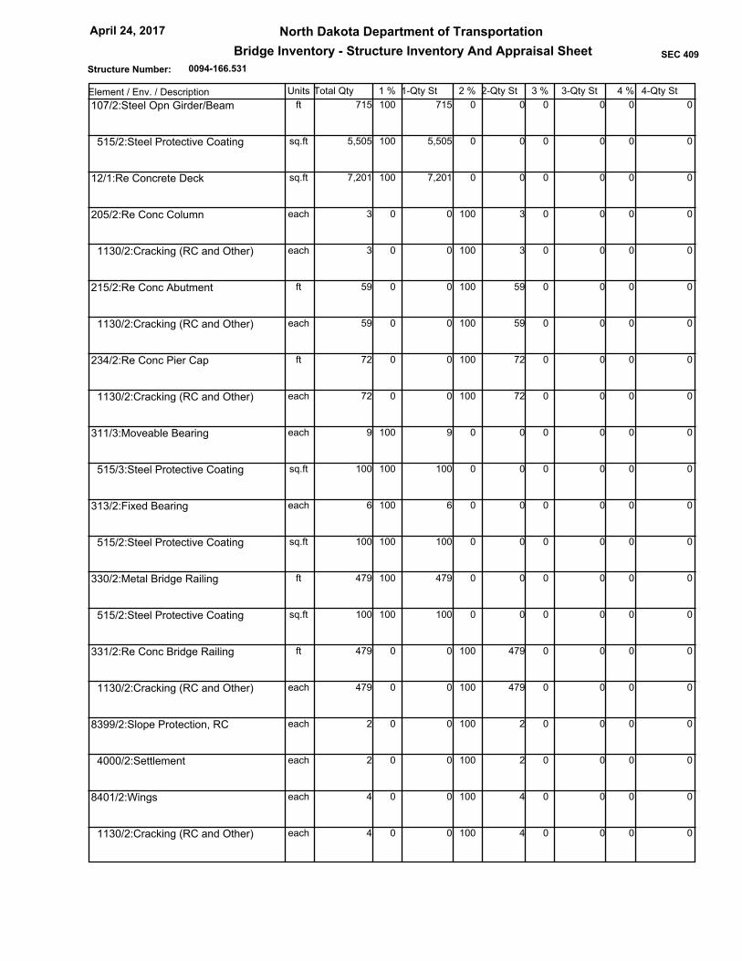
0094-166.531
North Dakota Department of Transportation
Bridge Inventory - Structure Inventory And Appraisal Sheet
April 24, 2017
SEC 409
Structure Number:
Bismarck District02 Highway District
Burleigh03 County
00815
I94/APPLE CREEK SEP06 Feats Intersect
7 EAST OF US 83 NORTH09 Location
14 Miles
Route On Structure
4 County Hwy 1 Mainline 0 N/A (NBI)
05 Inventory Route
Not applicable
26 Functional Rural, Local
27 Yr Built 106 Yr Reconstructed
28 Lanes on Structure
29 ADT 30 Year of ADT
31 Design Load
32 Approach Roadway Width
34 Skew
36 Traffic Safety Features
41 Structure Open, Closed or Posted
42 Type of Service
43 Main Struct Type
45 No. Spans in Main Unit
46 No. Approach Spans
47 Total Horizontal Clearance
48 Length of Max Span
49 Structure Length
50 Curb/Sidewalk Widths
51 Bridge Rdwy Width - Curb to Curb
52 Deck Width
53 Min Vert Clear. Over Bridge
54 Min Vert Underclearance
55 Min Lateral UnderClear. - Rt
56 Min Lateral UnderClear. - Lt
107 Deck Struct Type
108 Wearing Surface
Membrane
Dk Protect
208 Dk Overburden
58 Deck
59 Superstructure60 Substructure
61 Chan. & Chan. Protection
62 Culvert and Retaining Walls
64 Oper. Rating
66 Inv. Rating
67 Structural Condition
68 Deck Geometry
70 Bridge Posting
209 Posted in "Tons"
71 Waterway Adequacy
72 App. Rdwy. Alignment
90 Date of Last Inspection
92 Critical Feature Inspected / 93 Critical Feature Last Inpsection Dt
218 Channel Profile
113 Scour Critical
214 Delayed Inspection
210 Culvert / 211 Description
200 System Designation
201 Status
202 Sufficiency Rating
207 Transporter Erector Routes and Sites
216 Inspector
1965 -1
2
25 2014
M 13.5 (H 15) (live load for which structure was designated)
0.00
1 11 1
A Open, no restriction
Steel continuous
Stringer
4
0
24.0 Ft.
66 Ft.
241.14 Ft.
0.0 Ft Lt-Side
0.0 Ft Rt-Side
24.3 Ft.
29.9 Ft.
H Hwy beneath struct
H Hwy beneath struct
28.9 Ft.
1 Concrete-Cast-in-Place
1 Monolithic Concrete
0 None
None
None
7 Good
7 Good6 Satisfactory
N N/A (NBI)
N N/A (NBI)
N Not applicable
5 Above Min Tolerable
6 Equal Min Criteria
5 At/Above Legal Loads
00 Tons
8 Equal Desirable Crit
May 26, 2015
Fracture Critical
Underwater
Other Special
N
N
N
N
N Not Over Waterway
Not Applicable
Not Deficient
-1
79.60
1 - State
Kerzman,Jochim Sanborn
37 Tons
23 Tons
1 Highway - On
1 Highway - Under
01 State Highway Agency22 Owner
1 LF Load Factor
1 LF Load Factor
HS 20
HS 12
Identification
04 City GIBBS TOWNSHIP
14.99711 Milepoint
13 LRS Inv Route. Subroute
16 Latitude
17 Longitude
_
98 Border Bridge
99 Border Bridge Struct No.
0.00 %
Structure Type and Material
Classification
Unknown (P)
37 Historical Significance 3 Possibly eligible for
21 Maint Responsibility
20 Toll
12 Base Highway Network Not on Base Network
3 On free road
01 State Highway Agency
100 Defense Highway Designation
101 Parallel Structure Designation
102 Direction of Traffic
103 Temporary Structure Designation
104 Highway System of Inventory Rte
105 Federal Lands Highways
110 Designated National Network
112 NBIS Bridge Length
0 Not a STRAHNET hwy
No || bridge exists
Not Applicable (P)
0 Not on NHS
0 Not part of natl netwo
2 2-way traffic
Condition
44 Approach Struct Type Unknown (NBI)
Unknown (P)
Age and Service
Load Rating and Posting
109 Average Daily Truck Traffic
63 Operating Rating Method
65 Inventory Rating Method
Appraisal
5 Above Tolerable69 Underclear. Vert & Horiz
Geometric Data
10 Min Vert Clearance
33 Bridge Median 0 No median
35 Structure Flared 0 No flare
Inspections
91 Designated Inspection Frequency 24 Months
I-1-094(10)163213 Federal Aid Project Number
03/08/2016212 Structure Load Rated
Navigation Data
38 Navigation Control
39 Navigation Vertical Clearance
40 Navigation Horizontal Clearance
111 Pier or Abutment Protection
116 Minimum Navigation Vertical Clearance
NA-no waterway
Unknown (NBI)
0 Ft.
0 Ft.
Ft.
13.1 Ft.
29 Ft.
376068.9 5188348.5GPS Coordinates XY
46d 50' 12.00"
100d 37' 24.00"
99 Ft. 12 In.
99 Ft. 12 In.
16 Ft. 4 In.
1
Chaining Date None
19 Bypass, Detour Length
Yes
0094-166.531
North Dakota Department of Transportation
Bridge Inventory - Structure Inventory And Appraisal Sheet
April 24, 2017
SEC 409
Structure Number:
Element / Env. / Description Units Total Qty 1-Qty St 2-Qty St 3-Qty St1 % 2 % 3 % 4 % 4-Qty St
0 0 0 0 0 100 715 715ft 0 107/2:Steel Opn Girder/Beam
0 0 0 0 0 100 5,505 5,505sq.ft 0 515/2:Steel Protective Coating
0 0 0 0 0 100 7,201 7,201sq.ft 0 12/1:Re Concrete Deck
3 100 0 0 0 0 0 3each 0 205/2:Re Conc Column
3 100 0 0 0 0 0 3each 0 1130/2:Cracking (RC and Other)
59 100 0 0 0 0 0 59ft 0 215/2:Re Conc Abutment
59 100 0 0 0 0 0 59each 0 1130/2:Cracking (RC and Other)
72 100 0 0 0 0 0 72ft 0 234/2:Re Conc Pier Cap
72 100 0 0 0 0 0 72each 0 1130/2:Cracking (RC and Other)
0 0 0 0 0 100 9 9each 0 311/3:Moveable Bearing
0 0 0 0 0 100 100 100sq.ft 0 515/3:Steel Protective Coating
0 0 0 0 0 100 6 6each 0 313/2:Fixed Bearing
0 0 0 0 0 100 100 100sq.ft 0 515/2:Steel Protective Coating
0 0 0 0 0 100 479 479ft 0 330/2:Metal Bridge Railing
0 0 0 0 0 100 100 100sq.ft 0 515/2:Steel Protective Coating
479 100 0 0 0 0 0 479ft 0 331/2:Re Conc Bridge Railing
479 100 0 0 0 0 0 479each 0 1130/2:Cracking (RC and Other)
2 100 0 0 0 0 0 2each 0 8399/2:Slope Protection, RC
2 100 0 0 0 0 0 2each 0 4000/2:Settlement
4 100 0 0 0 0 0 4each 0 8401/2:Wings
4 100 0 0 0 0 0 4each 0 1130/2:Cracking (RC and Other)

0094-166.531
North Dakota Department of Transportation
Bridge Inventory - Structure Inventory And Appraisal Sheet
April 24, 2017
SEC 409
Structure Number:
Date 02-25-2004: Both abutments cracked along breastwall lines with effloresence. Salt spray from driving
lane causing rust on beam above traffic. NBI Remarks: Numerous small popouts in deck. Minor spalls on
backwalls under beams with seepage and effloresence. Small chip south pier column. Gap between slope
protection s and n abutments have been filled with grout minor scrapes on wb w&w1 beams from high loads.
Paint on flanges throughout bridge is starting to show failure, no section loss.
Remarks:
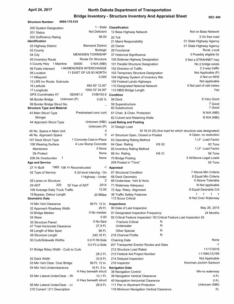
0094-170.519
North Dakota Department of Transportation
Bridge Inventory - Structure Inventory And Appraisal Sheet
April 24, 2017
SEC 409
Structure Number:
Bismarck District02 Highway District
Burleigh03 County
00000
I-94/MENOKEN INTERCHANGE06 Feats Intersect
11 EAST OF US 83 NORTH09 Location
20 Miles
Route On Structure
4 County Hwy 1 Mainline 0 N/A (NBI)
05 Inventory Route
Not applicable
26 Functional Rural, Local
27 Yr Built 106 Yr Reconstructed
28 Lanes on Structure
29 ADT 30 Year of ADT
31 Design Load
32 Approach Roadway Width
34 Skew
36 Traffic Safety Features
41 Structure Open, Closed or Posted
42 Type of Service
43 Main Struct Type
45 No. Spans in Main Unit
46 No. Approach Spans
47 Total Horizontal Clearance
48 Length of Max Span
49 Structure Length
50 Curb/Sidewalk Widths
51 Bridge Rdwy Width - Curb to Curb
52 Deck Width
53 Min Vert Clear. Over Bridge
54 Min Vert Underclearance
55 Min Lateral UnderClear. - Rt
56 Min Lateral UnderClear. - Lt
107 Deck Struct Type
108 Wearing Surface
Membrane
Dk Protect
208 Dk Overburden
58 Deck
59 Superstructure60 Substructure
61 Chan. & Chan. Protection
62 Culvert and Retaining Walls
64 Oper. Rating
66 Inv. Rating
67 Structural Condition
68 Deck Geometry
70 Bridge Posting
209 Posted in "Tons"
71 Waterway Adequacy
72 App. Rdwy. Alignment
90 Date of Last Inspection
92 Critical Feature Inspected / 93 Critical Feature Last Inpsection Dt
218 Channel Profile
113 Scour Critical
214 Delayed Inspection
210 Culvert / 211 Description
200 System Designation
201 Status
202 Sufficiency Rating
207 Transporter Erector Routes and Sites
216 Inspector
1965 -1
2
320 2014
M 18 (H 20) (live load for which structure was designated)
0.00
1 11 1
A Open, no restriction
Prestressed conc cont
Stringer
4
0
27.9 Ft.
66 Ft.
240.16 Ft.
0.0 Ft Lt-Side
0.0 Ft Rt-Side
28.2 Ft.
33.8 Ft.
H Hwy beneath struct
H Hwy beneath struct
28.9 Ft.
1 Concrete-Cast-in-Place
4 Low Slump Concrete
0 None
None
None
8 Very Good
7 Good7 Good
N N/A (NBI)
N N/A (NBI)
N Not applicable
7 Above Min Criteria
6 Equal Min Criteria
5 At/Above Legal Loads
00 Tons
8 Equal Desirable Crit
May 26, 2015
Fracture Critical
Underwater
Other Special
N
N
N
N
N Not Over Waterway
Not Applicable
Not Deficient
-1
98.50
1 - State
Kerzman,Jochim Sanborn
93 Tons
56 Tons
6 2d level interchg - On
1 Highway - Under
01 State Highway Agency22 Owner
1 LF Load Factor
1 LF Load Factor
HS 52
HS 31
Identification
04 City MENOKEN TOWNSHIP
0.00011 Milepoint
13 LRS Inv Route. Subroute
16 Latitude
17 Longitude
_
98 Border Bridge
99 Border Bridge Struct No.
0.00 %
Structure Type and Material
Classification
Unknown (P)
37 Historical Significance 3 Possibly eligible for
21 Maint Responsibility
20 Toll
12 Base Highway Network Not on Base Network
3 On free road
01 State Highway Agency
100 Defense Highway Designation
101 Parallel Structure Designation
102 Direction of Traffic
103 Temporary Structure Designation
104 Highway System of Inventory Rte
105 Federal Lands Highways
110 Designated National Network
112 NBIS Bridge Length
0 Not a STRAHNET hwy
No || bridge exists
Not Applicable (P)
0 Not on NHS
0 Not part of natl netwo
2 2-way traffic
Condition
44 Approach Struct Type Unknown (NBI)
Unknown (P)
Age and Service
Load Rating and Posting
12.00109 Average Daily Truck Traffic
63 Operating Rating Method
65 Inventory Rating Method
Appraisal
5 Above Tolerable69 Underclear. Vert & Horiz
Geometric Data
10 Min Vert Clearance
33 Bridge Median 0 No median
35 Structure Flared 0 No flare
Inspections
91 Designated Inspection Frequency 24 Months
I-1-094(12)169213 Federal Aid Project Number
11/17/2016212 Structure Load Rated
Navigation Data
38 Navigation Control
39 Navigation Vertical Clearance
40 Navigation Horizontal Clearance
111 Pier or Abutment Protection
116 Minimum Navigation Vertical Clearance
NA-no waterway
Unknown (NBI)
0 Ft.
0 Ft.
Ft.
13.1 Ft.
29 Ft.
382481.0 5188193.6GPS Coordinates XY
46d 50' 12.00"
100d 32' 24.00"
99 Ft. 12 In.
99 Ft. 12 In.
16 Ft. 5 In.
1
Chaining Date None
19 Bypass, Detour Length
Yes

0094-170.519
North Dakota Department of Transportation
Bridge Inventory - Structure Inventory And Appraisal Sheet
April 24, 2017
SEC 409
Structure Number:
Element / Env. / Description Units Total Qty 1-Qty St 2-Qty St 3-Qty St1 % 2 % 3 % 4 % 4-Qty St
0 0 0 0 0 100 945 945ft 0 109/2:Pre Opn Conc Girder/Beam
0 0 0 0 0 100 7,416 7,416sq.ft 0 12/1:Re Concrete Deck
0 0 0 0 0 100 6 6each 0 205/2:Re Conc Column
60 87 13 9 0 0 0 69ft 0 215/2:Re Conc Abutment
60 87 13 9 0 0 0 69each 0 1130/2:Cracking (RC and Other)
0 0 0 0 0 100 85 85ft 0 234/2:Re Conc Pier Cap
0 0 0 0 0 100 100 100sq.ft 0 321/2:Re Conc Approach Slab
0 0 0 0 0 100 479 479ft 0 330/2:Metal Bridge Railing
0 0 0 0 0 100 100 100sq.ft 0 515/2:Steel Protective Coating
479 100 0 0 0 0 0 479ft 0 331/2:Re Conc Bridge Railing
479 100 0 0 0 0 0 479each 0 1190/2:Abrasion(PSC/RC)
2 100 0 0 0 0 0 2each 0 8399/2:Slope Protection, RC
2 100 0 0 0 0 0 2each 0 4000/2:Settlement
1 25 0 0 0 75 3 4each 0 8401/2:Wings
1 25 0 0 0 75 3 4each 0 1130/2:Cracking (RC and Other)
Date 02-25-2004: Delminations over piers typical for age. 3/18/2008 - Deck was overlaid in 2007. NBI
Remarks: Deck was overlaid in 2007. Bridge rail, 13th post from north, west side has a large spall. Backwalls
cracked. Abuts are cracked and are seeping under outside beam seats. Top ne wing spalled 2" x 2'. The gaps
in slope protection filled with grout. Epoxy nosing has failed.
Remarks:

0094-176.501
North Dakota Department of Transportation
Bridge Inventory - Structure Inventory And Appraisal Sheet
April 24, 2017
SEC 409
Structure Number:
Bismarck District02 Highway District
Burleigh03 County
00827
I94/MCKENZIE INTERCHANGE06 Feats Intersect
6 WEST OF US 83 SOUTH09 Location
20 Miles
Route On Structure
4 County Hwy 1 Mainline 0 N/A (NBI)
05 Inventory Route
Not applicable
26 Functional Rural, Major Collector
27 Yr Built 106 Yr Reconstructed
28 Lanes on Structure
29 ADT 30 Year of ADT
31 Design Load
32 Approach Roadway Width
34 Skew
36 Traffic Safety Features
41 Structure Open, Closed or Posted
42 Type of Service
43 Main Struct Type
45 No. Spans in Main Unit
46 No. Approach Spans
47 Total Horizontal Clearance
48 Length of Max Span
49 Structure Length
50 Curb/Sidewalk Widths
51 Bridge Rdwy Width - Curb to Curb
52 Deck Width
53 Min Vert Clear. Over Bridge
54 Min Vert Underclearance
55 Min Lateral UnderClear. - Rt
56 Min Lateral UnderClear. - Lt
107 Deck Struct Type
108 Wearing Surface
Membrane
Dk Protect
208 Dk Overburden
58 Deck
59 Superstructure60 Substructure
61 Chan. & Chan. Protection
62 Culvert and Retaining Walls
64 Oper. Rating
66 Inv. Rating
67 Structural Condition
68 Deck Geometry
70 Bridge Posting
209 Posted in "Tons"
71 Waterway Adequacy
72 App. Rdwy. Alignment
90 Date of Last Inspection
92 Critical Feature Inspected / 93 Critical Feature Last Inpsection Dt
218 Channel Profile
113 Scour Critical
214 Delayed Inspection
210 Culvert / 211 Description
200 System Designation
201 Status
202 Sufficiency Rating
207 Transporter Erector Routes and Sites
216 Inspector
1965 -1
2
575 2014
M 18 (H 20) (live load for which structure was designated)
0.00
1 11 1
A Open, no restriction
Prestressed conc cont
Stringer
4
0
27.9 Ft.
66 Ft.
240.16 Ft.
0.0 Ft Lt-Side
0.0 Ft Rt-Side
28.2 Ft.
33.8 Ft.
H Hwy beneath struct
H Hwy beneath struct
28.9 Ft.
1 Concrete-Cast-in-Place
4 Low Slump Concrete
0 None
None
None
6 Satisfactory
7 Good6 Satisfactory
N N/A (NBI)
N N/A (NBI)
N Not applicable
6 Equal Min Criteria
5 Above Tolerable
5 At/Above Legal Loads
00 Tons
8 Equal Desirable Crit
June 01, 2015
Fracture Critical
Underwater
Other Special
N
N
N
N
N Not Over Waterway
Not Applicable
Not Deficient
-1
97.10
1 - State
Kerzman,Jochim Sanborn
99 Tons
63 Tons
6 2d level interchg - On
1 Highway - Under
01 State Highway Agency22 Owner
1 LF Load Factor
1 LF Load Factor
HS 55
HS 34
Identification
04 City MCKENZIE TOWNSHIP
1.00011 Milepoint
13 LRS Inv Route. Subroute
16 Latitude
17 Longitude
_
98 Border Bridge
99 Border Bridge Struct No.
0.00 %
Structure Type and Material
Classification
Unknown (P)
37 Historical Significance 3 Possibly eligible for
21 Maint Responsibility
20 Toll
12 Base Highway Network Not on Base Network
3 On free road
01 State Highway Agency
100 Defense Highway Designation
101 Parallel Structure Designation
102 Direction of Traffic
103 Temporary Structure Designation
104 Highway System of Inventory Rte
105 Federal Lands Highways
110 Designated National Network
112 NBIS Bridge Length
0 Not a STRAHNET hwy
No || bridge exists
Not Applicable (P)
0 Not on NHS
0 Not part of natl netwo
2 2-way traffic
Condition
44 Approach Struct Type Unknown (NBI)
Unknown (P)
Age and Service
Load Rating and Posting
14.00109 Average Daily Truck Traffic
63 Operating Rating Method
65 Inventory Rating Method
Appraisal
5 Above Tolerable69 Underclear. Vert & Horiz
Geometric Data
10 Min Vert Clearance
33 Bridge Median 0 No median
35 Structure Flared 0 No flare
Inspections
91 Designated Inspection Frequency 24 Months
I-1-094(12)169213 Federal Aid Project Number
11/17/2016212 Structure Load Rated
Navigation Data
38 Navigation Control
39 Navigation Vertical Clearance
40 Navigation Horizontal Clearance
111 Pier or Abutment Protection
116 Minimum Navigation Vertical Clearance
NA-no waterway
Unknown (NBI)
0 Ft.
0 Ft.
Ft.
13.1 Ft.
27 Ft.
392111.6 5187961.4GPS Coordinates XY
46d 50' 06.00"
100d 24' 48.00"
99 Ft. 12 In.
99 Ft. 12 In.
16 Ft. 3 In.
1
Chaining Date None
19 Bypass, Detour Length
Yes
0094-176.501
North Dakota Department of Transportation
Bridge Inventory - Structure Inventory And Appraisal Sheet
April 24, 2017
SEC 409
Structure Number:
Element / Env. / Description Units Total Qty 1-Qty St 2-Qty St 3-Qty St1 % 2 % 3 % 4 % 4-Qty St
0 0 0 0 0 100 945 945ft 0 109/2:Pre Opn Conc Girder/Beam
0 0 0 0 0 100 7,416 7,416sq.ft 0 12/2:Re Concrete Deck
0 0 0 0 0 100 7,416 7,416sq.ft 0 510/2:Wearing Surfaces
0 0 0 0 0 100 6 6each 0 205/2:Re Conc Column
62 90 10 7 0 0 0 69ft 0 215/2:Re Conc Abutment
0 0 100 7 0 0 0 7each 0 1080/2:Delamination/Spall/Patched Area
62 100 0 0 0 0 0 62each 0 1130/2:Cracking (RC and Other)
0 0 0 0 0 100 85 85ft 0 234/2:Re Conc Pier Cap
0 0 0 0 0 100 100 100sq.ft 0 321/2:Re Conc Approach Slab
0 0 0 0 0 100 479 479ft 0 330/2:Metal Bridge Railing
0 0 0 0 0 100 100 100sq.ft 0 515/2:Steel Protective Coating
2 100 0 0 0 0 0 2each 0 8399/2:Slope Protection, RC
2 100 0 0 0 0 0 2each 0 4000/2:Settlement
4 100 0 0 0 0 0 4each 0 8401/2:Wings
4 100 0 0 0 0 0 4each 0 1130/2:Cracking (RC and Other)
Date 02-24-2004: Deck in heavy traffic area on route to N.I.C. main Bismarck gravel pit. High salt on deck.
3/17/2008 - Deck overlaid in 2007. NBI Remarks: Both abutments have 4" x 8" x 2' spalls under east & west
beams. Both backwalls have hairline cracks where they intersect abutments. Slope protection settled approx.
3" spalls under w beam n abut.& e beam s abut.Have fallen away to reveal wooden blocks supporting beams.
Deck was overlayed in 2007.
Remarks:
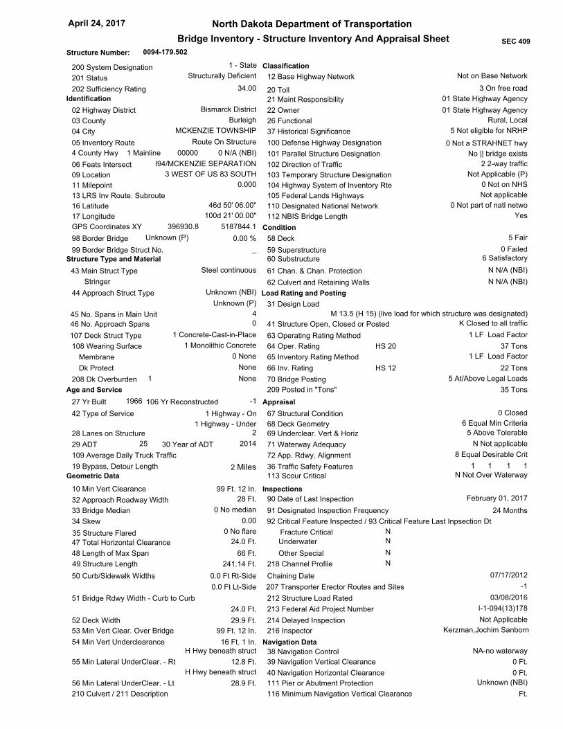
0094-179.502
North Dakota Department of Transportation
Bridge Inventory - Structure Inventory And Appraisal Sheet
April 24, 2017
SEC 409
Structure Number:
Bismarck District02 Highway District
Burleigh03 County
00000
I94/MCKENZIE SEPARATION06 Feats Intersect
3 WEST OF US 83 SOUTH09 Location
2 Miles
Route On Structure
4 County Hwy 1 Mainline 0 N/A (NBI)
05 Inventory Route
Not applicable
26 Functional Rural, Local
27 Yr Built 106 Yr Reconstructed
28 Lanes on Structure
29 ADT 30 Year of ADT
31 Design Load
32 Approach Roadway Width
34 Skew
36 Traffic Safety Features
41 Structure Open, Closed or Posted
42 Type of Service
43 Main Struct Type
45 No. Spans in Main Unit
46 No. Approach Spans
47 Total Horizontal Clearance
48 Length of Max Span
49 Structure Length
50 Curb/Sidewalk Widths
51 Bridge Rdwy Width - Curb to Curb
52 Deck Width
53 Min Vert Clear. Over Bridge
54 Min Vert Underclearance
55 Min Lateral UnderClear. - Rt
56 Min Lateral UnderClear. - Lt
107 Deck Struct Type
108 Wearing Surface
Membrane
Dk Protect
208 Dk Overburden
58 Deck
59 Superstructure60 Substructure
61 Chan. & Chan. Protection
62 Culvert and Retaining Walls
64 Oper. Rating
66 Inv. Rating
67 Structural Condition
68 Deck Geometry
70 Bridge Posting
209 Posted in "Tons"
71 Waterway Adequacy
72 App. Rdwy. Alignment
90 Date of Last Inspection
92 Critical Feature Inspected / 93 Critical Feature Last Inpsection Dt
218 Channel Profile
113 Scour Critical
214 Delayed Inspection
210 Culvert / 211 Description
200 System Designation
201 Status
202 Sufficiency Rating
207 Transporter Erector Routes and Sites
216 Inspector
1966 -1
2
25 2014
M 13.5 (H 15) (live load for which structure was designated)
0.00
1 11 1
K Closed to all traffic
Steel continuous
Stringer
4
0
24.0 Ft.
66 Ft.
241.14 Ft.
0.0 Ft Lt-Side
0.0 Ft Rt-Side
24.0 Ft.
29.9 Ft.
H Hwy beneath struct
H Hwy beneath struct
28.9 Ft.
1 Concrete-Cast-in-Place
1 Monolithic Concrete
0 None
None
None
5 Fair
0 Failed6 Satisfactory
N N/A (NBI)
N N/A (NBI)
N Not applicable
0 Closed
6 Equal Min Criteria
5 At/Above Legal Loads
35 Tons
8 Equal Desirable Crit
February 01, 2017
Fracture Critical
Underwater
Other Special
N
N
N
N
N Not Over Waterway
Not Applicable
Structurally Deficient
-1
34.00
1 - State
Kerzman,Jochim Sanborn
37 Tons
22 Tons
1 Highway - On
1 Highway - Under
01 State Highway Agency22 Owner
1 LF Load Factor
1 LF Load Factor
HS 20
HS 12
Identification
04 City MCKENZIE TOWNSHIP
0.00011 Milepoint
13 LRS Inv Route. Subroute
16 Latitude
17 Longitude
_
98 Border Bridge
99 Border Bridge Struct No.
0.00 %
Structure Type and Material
Classification
Unknown (P)
37 Historical Significance 5 Not eligible for NRHP
21 Maint Responsibility
20 Toll
12 Base Highway Network Not on Base Network
3 On free road
01 State Highway Agency
100 Defense Highway Designation
101 Parallel Structure Designation
102 Direction of Traffic
103 Temporary Structure Designation
104 Highway System of Inventory Rte
105 Federal Lands Highways
110 Designated National Network
112 NBIS Bridge Length
0 Not a STRAHNET hwy
No || bridge exists
Not Applicable (P)
0 Not on NHS
0 Not part of natl netwo
2 2-way traffic
Condition
44 Approach Struct Type Unknown (NBI)
Unknown (P)
Age and Service
Load Rating and Posting
109 Average Daily Truck Traffic
63 Operating Rating Method
65 Inventory Rating Method
Appraisal
5 Above Tolerable69 Underclear. Vert & Horiz
Geometric Data
10 Min Vert Clearance
33 Bridge Median 0 No median
35 Structure Flared 0 No flare
Inspections
91 Designated Inspection Frequency 24 Months
I-1-094(13)178213 Federal Aid Project Number
03/08/2016212 Structure Load Rated
Navigation Data
38 Navigation Control
39 Navigation Vertical Clearance
40 Navigation Horizontal Clearance
111 Pier or Abutment Protection
116 Minimum Navigation Vertical Clearance
NA-no waterway
Unknown (NBI)
0 Ft.
0 Ft.
Ft.
12.8 Ft.
28 Ft.
396930.8 5187844.1GPS Coordinates XY
46d 50' 06.00"
100d 21' 00.00"
99 Ft. 12 In.
99 Ft. 12 In.
16 Ft. 1 In.
1
Chaining Date 07/17/2012
19 Bypass, Detour Length
Yes
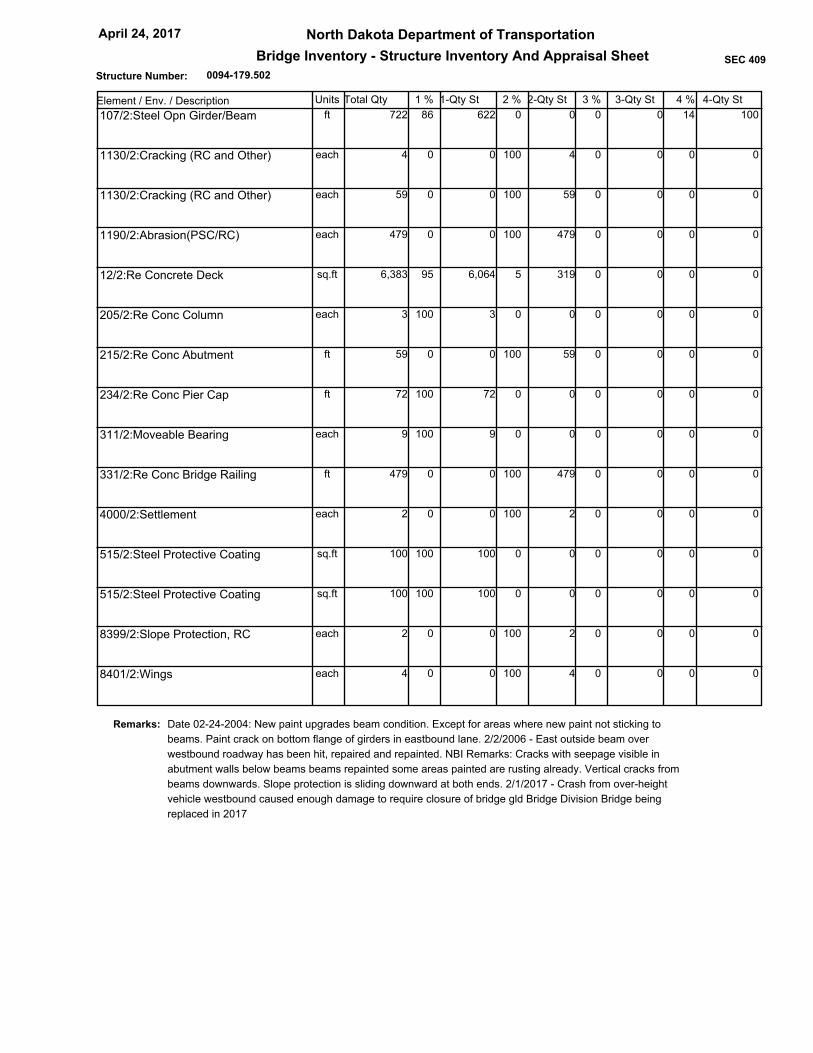
0094-179.502
North Dakota Department of Transportation
Bridge Inventory - Structure Inventory And Appraisal Sheet
April 24, 2017
SEC 409
Structure Number:
Element / Env. / Description Units Total Qty 1-Qty St 2-Qty St 3-Qty St1 % 2 % 3 % 4 % 4-Qty St
0 0 0 0 14 86 622 722ft 100 107/2:Steel Opn Girder/Beam
4 100 0 0 0 0 0 4each 0 1130/2:Cracking (RC and Other)
59 100 0 0 0 0 0 59each 0 1130/2:Cracking (RC and Other)
479 100 0 0 0 0 0 479each 0 1190/2:Abrasion(PSC/RC)
319 5 0 0 0 95 6,064 6,383sq.ft 0 12/2:Re Concrete Deck
0 0 0 0 0 100 3 3each 0 205/2:Re Conc Column
59 100 0 0 0 0 0 59ft 0 215/2:Re Conc Abutment
0 0 0 0 0 100 72 72ft 0 234/2:Re Conc Pier Cap
0 0 0 0 0 100 9 9each 0 311/2:Moveable Bearing
479 100 0 0 0 0 0 479ft 0 331/2:Re Conc Bridge Railing
2 100 0 0 0 0 0 2each 0 4000/2:Settlement
0 0 0 0 0 100 100 100sq.ft 0 515/2:Steel Protective Coating
0 0 0 0 0 100 100 100sq.ft 0 515/2:Steel Protective Coating
2 100 0 0 0 0 0 2each 0 8399/2:Slope Protection, RC
4 100 0 0 0 0 0 4each 0 8401/2:Wings
Date 02-24-2004: New paint upgrades beam condition. Except for areas where new paint not sticking to
beams. Paint crack on bottom flange of girders in eastbound lane. 2/2/2006 - East outside beam over
westbound roadway has been hit, repaired and repainted. NBI Remarks: Cracks with seepage visible in
abutment walls below beams beams repainted some areas painted are rusting already. Vertical cracks from
beams downwards. Slope protection is sliding downward at both ends. 2/1/2017 - Crash from over-height
vehicle westbound caused enough damage to require closure of bridge gld Bridge Division Bridge being
replaced in 2017
Remarks:

0094-182.488
North Dakota Department of Transportation
Bridge Inventory - Structure Inventory And Appraisal Sheet
April 24, 2017
SEC 409
Structure Number:
Bismarck District02 Highway District
Burleigh03 County
00083
I94/STERLING INTER.06 Feats Intersect
JUNCTION US 83 S-STERLING09 Location
10 Miles
Route On Structure
2 U.S. Numbered Hwy1 Mainline 0 N/A (NBI)
05 Inventory Route
Not applicable
26 Functional Rural, Principal Arterial - Other
27 Yr Built 106 Yr Reconstructed
28 Lanes on Structure
29 ADT 30 Year of ADT
31 Design Load
32 Approach Roadway Width
34 Skew
36 Traffic Safety Features
41 Structure Open, Closed or Posted
42 Type of Service
43 Main Struct Type
45 No. Spans in Main Unit
46 No. Approach Spans
47 Total Horizontal Clearance
48 Length of Max Span
49 Structure Length
50 Curb/Sidewalk Widths
51 Bridge Rdwy Width - Curb to Curb
52 Deck Width
53 Min Vert Clear. Over Bridge
54 Min Vert Underclearance
55 Min Lateral UnderClear. - Rt
56 Min Lateral UnderClear. - Lt
107 Deck Struct Type
108 Wearing Surface
Membrane
Dk Protect
208 Dk Overburden
58 Deck
59 Superstructure60 Substructure
61 Chan. & Chan. Protection
62 Culvert and Retaining Walls
64 Oper. Rating
66 Inv. Rating
67 Structural Condition
68 Deck Geometry
70 Bridge Posting
209 Posted in "Tons"
71 Waterway Adequacy
72 App. Rdwy. Alignment
90 Date of Last Inspection
92 Critical Feature Inspected / 93 Critical Feature Last Inpsection Dt
218 Channel Profile
113 Scour Critical
214 Delayed Inspection
210 Culvert / 211 Description
200 System Designation
201 Status
202 Sufficiency Rating
207 Transporter Erector Routes and Sites
216 Inspector
1966 1985
2
2,150 2014
MS 18 (HS 20) (live load for which structure was designated)
0.00
1 11 1
A Open, no restriction
Steel continuous
Stringer
4
0
29.9 Ft.
66 Ft.
240.16 Ft.
0.0 Ft Lt-Side
0.0 Ft Rt-Side
30.2 Ft.
36.1 Ft.
H Hwy beneath struct
H Hwy beneath struct
28.9 Ft.
1 Concrete-Cast-in-Place
4 Low Slump Concrete
0 None
None
None
6 Satisfactory
7 Good7 Good
N N/A (NBI)
N N/A (NBI)
N Not applicable
7 Above Min Criteria
4 Tolerable
5 At/Above Legal Loads
00 Tons
8 Equal Desirable Crit
May 27, 2015
Fracture Critical
Underwater
Other Special
N
N
N
N
N Not Over Waterway
Not Applicable
Not Deficient
-1
86.40
1 - State
Kerzman,Jochim Sanborn
68 Tons
41 Tons
6 2d level interchg - On
1 Highway - Under
01 State Highway Agency22 Owner
1 LF Load Factor
1 LF Load Factor
HS 37
HS 22
Identification
04 City STERLING TOWNSHIP
65.92011 Milepoint
13 LRS Inv Route. Subroute 0000000000 00
16 Latitude
17 Longitude
_
98 Border Bridge
99 Border Bridge Struct No.
0.00 %
Structure Type and Material
Classification
Unknown (P)
37 Historical Significance 5 Not eligible for NRHP
21 Maint Responsibility
20 Toll
12 Base Highway Network On Base Network
3 On free road
01 State Highway Agency
100 Defense Highway Designation
101 Parallel Structure Designation
102 Direction of Traffic
103 Temporary Structure Designation
104 Highway System of Inventory Rte
105 Federal Lands Highways
110 Designated National Network
112 NBIS Bridge Length
0 Not a STRAHNET hwy
No || bridge exists
Not Applicable (P)
1 On the NHS
1 Part of natl network
2 2-way traffic
Condition
44 Approach Struct Type Unknown (NBI)
Unknown (P)
Age and Service
Load Rating and Posting
9.00109 Average Daily Truck Traffic
63 Operating Rating Method
65 Inventory Rating Method
Appraisal
5 Above Tolerable69 Underclear. Vert & Horiz
Geometric Data
10 Min Vert Clearance
33 Bridge Median 0 No median
35 Structure Flared 0 No flare
Inspections
91 Designated Inspection Frequency 24 Months
IR-094-5(33)158213 Federal Aid Project Number
11/17/2016212 Structure Load Rated
Navigation Data
38 Navigation Control
39 Navigation Vertical Clearance
40 Navigation Horizontal Clearance
111 Pier or Abutment Protection
116 Minimum Navigation Vertical Clearance
NA-no waterway
Unknown (NBI)
0 Ft.
0 Ft.
Ft.
13.1 Ft.
44 Ft.
401733.0 5187780.4GPS Coordinates XY
46d 50' 11.00"
100d 17' 19.00"
99 Ft. 12 In.
99 Ft. 12 In.
16 Ft. 3 In.
1
Chaining Date None
19 Bypass, Detour Length
Yes
0094-182.488
North Dakota Department of Transportation
Bridge Inventory - Structure Inventory And Appraisal Sheet
April 24, 2017
SEC 409
Structure Number:
Element / Env. / Description Units Total Qty 1-Qty St 2-Qty St 3-Qty St1 % 2 % 3 % 4 % 4-Qty St
0 0 0 0 0 100 961 961ft 0 107/2:Steel Opn Girder/Beam
0 0 0 0 0 100 8,631 8,631sq.ft 0 515/2:Steel Protective Coating
391 5 0 0 0 95 7,434 7,825sq.ft 0 12/4:Re Concrete Deck
391 100 0 0 0 0 0 391each 0 1130/4:Cracking (RC and Other)
0 0 0 0 100 0 0 7,825sq.ft 7,825 510/4:Wearing Surfaces
0 0 0 0 0 100 6 6each 0 205/2:Re Conc Column
72 100 0 0 0 0 0 72ft 0 215/2:Re Conc Abutment
72 100 0 0 0 0 0 72each 0 1130/2:Cracking (RC and Other)
0 0 0 0 0 100 92 92ft 0 234/2:Re Conc Pier Cap
0 0 0 0 0 100 12 12each 0 311/2:Moveable Bearing
0 0 0 0 0 100 100 100sq.ft 0 515/2:Steel Protective Coating
8 100 0 0 0 0 0 8each 0 313/2:Fixed Bearing
0 0 0 0 0 100 100 100sq.ft 0 515/2:Steel Protective Coating
0 0 0 0 0 100 100 100sq.ft 0 321/4:Re Conc Approach Slab
0 0 0 0 0 100 479 479ft 0 330/4:Metal Bridge Railing
0 0 0 0 0 100 100 100sq.ft 0 515/4:Steel Protective Coating
475 99 1 4 0 0 0 479ft 0 331/4:Re Conc Bridge Railing
2 100 0 0 0 0 0 2each 0 8399/2:Slope Protection, RC
2 100 0 0 0 0 0 2each 0 4000/2:Settlement
4 100 0 0 0 0 0 4each 0 8401/2:Wings
4 100 0 0 0 0 0 4each 0 1130/2:Cracking (RC and Other)

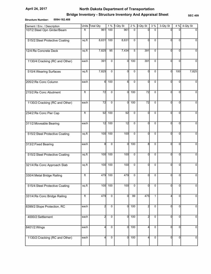
0094-182.488
North Dakota Department of Transportation
Bridge Inventory - Structure Inventory And Appraisal Sheet
April 24, 2017
SEC 409
Structure Number:
Date 02-24-2004: Ramping from roadway and approach slab is affecting bridge. Beams have fresh paint with
only speckled rust over driving lane. Wings all uniformly cracked. Flanges on facia beams rusting. NBI
Remarks: Chip in south rail of south span. Minor cracks in backwalls by beams,seepage visible.Diagonal
cracks with efflorescence visible from under curbs to beam flange all corners. Fine vertical cracks from bottom
of all beams to ground. Slope protection starting to slide down again. Cracks in deck with efflorescence visible
on bottom side. End wall under nw beam has minor spalling. Moderate rusting in small areas on flanges of
exterior beams, with some minimal section loss at bearing. Some minor rust spots & pitting on the rest of the
interior beams. Nosing concrete is cracked and delamination sealant has failed.All trans cracks in entire deck
show sounds of delam
Remarks: