nsw state tsunami plan - emergency.nsw.gov.au€¦ · this nsw state tsunami plan is a sub plan of...
TRANSCRIPT
NSW STATE TSUNAMI PLAN
A Sub Plan of the
State Emergency Management Plan (EMPLAN)
March 2015 v1.0

March 2015 NSW State Tsunami Plan Page | II
AUTHORISATION
This NSW State Tsunami Plan is a sub plan of the State Emergency Management Plan
(EMPLAN). It has been prepared in accordance with the provisions of the State Emergency
Service Act 1989 (NSW) and is authorised by the State Emergency Management Committee
in accordance with the provisions of the State Emergency and Rescue Management Act
1989 (NSW).
Recommended
(Mr Adam Dent) Commissioner NSW State Emergency Service
Dated:
Approved
(Mr Greg Mullins AFSM) Acting Chairperson State Emergency Management Committee
Dated:

March 2015 NSW State Tsunami Plan Page | III
VERSION HISTORY
The following table lists all previously endorsed versions of this plan.
Plan Endorsed
New South Wales Tsunami Emergency Sub Plan December 2005
New South Wales Tsunami Emergency Sub Plan December 2008
AMENDMENT LIST
Proposals for amendment to this plan are to be forwarded to:
Manager, Emergency Risk Management Branch
NSW State Emergency Service
PO Box 6126, Wollongong, NSW, 2500
Amendments promulgated are to be certified below when entered.
Amendment Number
Description Updated by Date
Intentionally Blank
Intentionally Blank
Intentionally Blank
Intentionally Blank
Intentionally Blank
Intentionally Blank
Intentionally Blank

March 2015 NSW State Tsunami Plan Page | IV
DISTRIBUTION LIST
This sub plan is distributed through the Ministry for Police and Emergency Services in
electronic format and is maintained on the State Emergency Management Committee
(www.emergency.nsw.gov.au) and NSW State Emergency Service (www.ses.nsw.gov.au)
websites.

March 2015 NSW State Tsunami Plan Page | V
CONTENTS
NSW STATE TSUNAMI PLAN ................................................... I
VERSION HISTORY ............................................................................................. III
AMENDMENT LIST ............................................................................................ III
DISTRIBUTION LIST............................................................................................ IV
CONTENTS ......................................................................................................... V
LIST OF TABLES ................................................................................................. IX
LIST OF FIGURES ................................................................................................ IX
LIST OF MAPS.................................................................................................... IX
ABBREVIATIONS................................................................................................. X
GLOSSARY ....................................................................................................... XIII
PART 1 - INTRODUCTION .................................................................................1
1.1 PURPOSE .............................................................................................................1
1.2 AUTHORITY .........................................................................................................1
1.3 SCOPE .................................................................................................................1
1.4 AREA COVERED BY THE PLAN .............................................................................2
1.5 TSUNAMI AND THEIR POTENTIAL EFFECTS ON NSW .........................................2
PART 2 - ROLES AND RESPONSIBILITIES ............................................................3
2.1 GENERAL .............................................................................................................3
2.2 NSW STATE EMERGENCY SERVICE ......................................................................3
2.3 COMMUNITY MEMBERS OF NSW ......................................................................5
2.4 AGRICULTURE AND ANIMAL SERVICES FUNCTIONAL AREA ...............................6
2.5 AMBULANCE SERVICE OF NSW ...........................................................................6
2.6 ATTORNEY-GENERAL’S DEPARTMENT (AGD) .....................................................6
2.7 AUSTRALIAN GOVERNMENT BUREAU OF METEOROLOGY (THE BUREAU) ........6
2.8 AUSTRALIAN MARINE SAFETY AUTHORITY (AMSA) ...........................................7
2.9 EMERGENCY INFORMATION COORDINATION UNIT ...........................................7
2.10 ENERGY AND UTILITY SERVICES FUNCTIONAL AREA ..........................................7
2.11 ENGINEERING SERVICES FUNCTIONAL AREA......................................................8
2.12 ENVIRONMENTAL SERVICES FUNCTIONAL AREA ...............................................8
2.13 FIRE AND RESCUE NSW (FRNSW) .......................................................................8
2.14 FORESTRY CORPORATION NSW ..........................................................................9
2.15 GEOSCIENCE AUSTRALIA ....................................................................................9
2.16 HEALTH SERVICES FUNCTIONAL AREA ...............................................................9
2.17 LOCAL GOVERNMENT COUNCILS IN NSW COASTAL AREAS ............................ 10
March 2015 NSW State Tsunami Plan Page | VI
2.18 LORD HOWE ISLAND PORT OPERATIONS OFFICER .......................................... 10
2.19 MANLY HYDRAULICS LABORATORY ................................................................. 10
2.20 MARINE PARKS AUTHORITY NSW .................................................................... 11
2.21 MARINE RESCUE NSW ..................................................................................... 11
2.22 MINISTRY FOR POLICE AND EMERGENCY SERVICES (NSW) ............................ 11
2.23 NSW ASSOCIATION OF INDEPENDENT SCHOOLS ............................................ 12
2.24 NSW DEPARTMENT OF EDUCATION AND COMMUNITIES AND CATHOLIC
EDUCATION COMMISSION .......................................................................................... 12
2.25 NSW OFFICE OF ENVIRONMENT AND HERITAGE ............................................ 12
2.26 NSW POLICE FORCE ......................................................................................... 12
2.27 NSW RURAL FIRE SERVICE (NSW RFS) ............................................................. 13
2.28 NSW VOLUNTEER RESCUE ASSOCIATION (VRA) (LAND RESCUE UNITS) ......... 14
2.29 PORT AUTHORITY OF NSW .............................................................................. 14
2.30 PUBLIC INFORMATION SERVICES FUNCTIONAL AREA ..................................... 14
2.31 STATE EMERGENCY OPERATIONS CENTRE ...................................................... 15
2.32 STATE EMERGENCY OPERATIONS CONTROLLER (SEOCON) ............................ 15
2.33 STATE EMERGENCY RECOVERY CONTROLLER ................................................. 15
2.34 SURF LIFE SAVING NSW ................................................................................... 15
2.35 TELECOMMUNICATION SERVICES FUNCTIONAL AREA ................................... 16
2.36 TRANSPORT SERVICES FUNCTIONAL AREA COORDINATOR (TSFAC) ............... 16
2.37 WELFARE SERVICES FUNCTIONAL AREA .......................................................... 17
PART 3 - PREPAREDNESS ............................................................................... 19
3.1 INTRODUCTION ............................................................................................... 19
3.2 BASIS FOR PLANNING ...................................................................................... 19
3.3 REGION AND LOCAL LEVEL PLANNING ............................................................ 20
3.4 COMMUNITY RESILIENCE ................................................................................ 20
3.5 WARNING - GENERAL ...................................................................................... 21
3.6 AUSTRALIAN TSUNAMI WARNING SYSTEM (ATWS)........................................ 22
3.7 DETECTION AND REPORTING OF TSUNAMI .................................................... 23
3.8 EVACUATION PLANNING ................................................................................. 25
3.9 FIRE AND HAZARDOUS MATERIAL INCIDENTS PLANNING .............................. 26
3.10 TSUNAMI INTELLIGENCE DEVELOPMENT ........................................................ 27
3.11 AUSTRALIAN TSUNAMI ADVISORY GROUP ..................................................... 27
3.12 EMERGENCY ALERT.......................................................................................... 27
PART 4 - RESPONSE ....................................................................................... 28
4.1 BACKGROUND ................................................................................................. 28
4.2 OPERATIONAL OBJECTIVES .............................................................................. 28

March 2015 NSW State Tsunami Plan Page | VII
4.3 OPERATIONAL STRATEGIES ............................................................................. 28
4.4 PRINCIPLES OF TSUNAMI OPERATIONS ........................................................... 29
4.5 ACTIVATION ..................................................................................................... 30
4.6 CONTROL ARRANGEMENTS ............................................................................. 30
4.7 OPERATIONS CENTRES..................................................................................... 31
4.8 SEQUENCE OF MOBILISATION ......................................................................... 31
4.9 SEQUENCE OF RESPONSE OPERATIONS .......................................................... 34
4.10 PUBLIC INFORMATION .................................................................................... 42
4.11 WARNING DISSEMINATION ............................................................................. 42
4.12 INFORMATION MANAGEMENT ....................................................................... 44
4.13 RECONNAISSANCE ........................................................................................... 44
4.14 DAMAGE CONTROL ......................................................................................... 45
4.15 DISASTER WELFARE ......................................................................................... 45
4.16 DISASTER VICTIM IDENTIFICATION AND REGISTRATION................................. 46
4.17 MANAGEMENT OF ENERGY AND UTILITIES ..................................................... 46
4.18 MANAGEMENT OF ENGINEERING SUPPORT ................................................... 46
4.19 HEALTH RESPONSE .......................................................................................... 46
4.20 MANAGEMENT OF ANIMALS ........................................................................... 47
4.21 TELECOMMUNICATIONS ................................................................................. 47
4.22 MANAGEMENT OF TRANSPORT ...................................................................... 47
4.23 FIRE AND HAZARDOUS MATERIALS ................................................................. 48
4.24 DEFENCE ASSISTANCE ...................................................................................... 48
4.25 COMMUNICATIONS ......................................................................................... 48
4.26 EVACUATION ................................................................................................... 49
4.27 PROTECTION AND PRE-DEPLOYMENT OF ESSENTIAL RESOURCES ................. 50
4.28 RESTORATION OF ESSENTIAL UTILITIES ........................................................... 50
4.29 RESUPPLY OF ISOLATED COMMUNITIES ......................................................... 51
4.30 RE-ESTABLISHMENT OF ACCESS ...................................................................... 51
4.31 RESTRICTION OF ACCESS AND SECURITY ......................................................... 51
4.32 MANAGEMENT OF WATERWAYS .................................................................... 52
4.33 SEARCH AND RESCUE ...................................................................................... 52
4.34 REQUESTS FOR ASSISTANCE ............................................................................ 53
4.35 LIAISON ............................................................................................................ 54
4.36 LOGISTICS ........................................................................................................ 54
4.37 ALL CLEAR AND RETURN .................................................................................. 55
4.38 AFTER ACTION REVIEWS .................................................................................. 56
PART 5 - RECOVERY ....................................................................................... 57

March 2015 NSW State Tsunami Plan Page | VIII
5.1 RECOVERY OPERATIONS .................................................................................. 57
TSUNAMI HAZARD AND RISK IN NEW SOUTH WALES ........... 58
PART 6 - GENERAL ......................................................................................... 59
6.1 WHAT IS A TSUNAMI? ..................................................................................... 59
6.2 TSUNAMI GENERATION ................................................................................... 60
6.3 TSUNAMI IMPACT ............................................................................................ 60
PART 7 - NEW SOUTH WALES TSUNAMI HAZARD ........................................... 61
7.1 NSW TSUNAMI SOURCES ................................................................................. 61
7.2 EARTHQUAKE SOURCES ................................................................................... 61
7.3 VOLCANO SOURCES ......................................................................................... 61
7.4 LANDSLIDE SOURCES (LAND AND SUBMARINE) .............................................. 61
7.5 ASTEROID SOURCES ......................................................................................... 62
7.6 TSUNAMI HISTORY........................................................................................... 62
7.7 TSUNAMI HAZARD ASSESSMENT ..................................................................... 63
PART 8 - NEW SOUTH WALES TSUNAMI RISK AND VULNERABILITY ................ 64
8.1 TSUNAMI RISK ................................................................................................. 64
8.2 TSUNAMI COMMUNITY VULNERABILITY ......................................................... 65
8.3 WARNING AND ARRIVAL TIMES ...................................................................... 68
TSUNAMI WARNING ARRANGEMENT SUMMARY, TSUNAMI SOURCE AND DART LOCATIONS ........................................... 70
8.4 LOCATION OF DEEP OCEAN TSUNAMI BUOYS USED TO DETECT AND
EVALUATE TSUNAMI .................................................................................................... 71
8.5 LOCATION OF PLATE BOUNDARIES AND SUBDUCTION ZONES ....................... 72
8.6 TSUNAMI WARNING TRANSMISSION .............................................................. 73
8.7 GENERAL TSUNAMI WARNING TRANSMISSION TO NSW ............................... 74
8.8 DISSEMINATION THE BUREAU NSW TSUNAMI WARNINGS TO MARINE BASED
RISK GROUPS ............................................................................................................... 75
8.9 DISSEMINATION OF THE BUREAU NSW TSUNAMI WARNINGS TO LAND BASED
RISK GROUPS ............................................................................................................... 76
8.10 SUMMARY OF WARNING ARRANGEMENTS AND SUGGESTED METHODS OF
WARNING .................................................................................................................... 77
LIST OF REFERENCES ......................................................................................... 80

March 2015 NSW State Tsunami Plan Page | IX
LIST OF TABLES
Table 1: Typical actions in pre-impact phase. ......................................................................... 34
Table 2: Typical actions in Impact phase. ................................................................................ 37
Table 3: Typical actions in Immediate Post-Impact phase. ..................................................... 39
Table 4: Lists the calculated addresses (GURAS) located within tsunami inundation model
extents (by post code). ............................................................................................................ 64
Table 5: Examples of land and marine based assets and users vulnerable to tsunami. ......... 66
Table 6: Possible Vulnerable Population in NSW (2011 census) within 1km of coast and below
the 10m contour height (AHD). ............................................................................................... 67
Table 7: Summary List of Modelled Tsunami Scenario Arrival Times (21) .............................. 68
Table 8: Summary of Warning Arrangements and Suggested Methods of Warning .............. 77
LIST OF FIGURES
Figure 1: Australian Tsunami Warning System (9) .................................................................. 22
Figure 2: Tsunami Warnings and Schedule (9) ........................................................................ 23
Figure 3: Tsunami Warning Message Types and Purpose (9) .................................................. 24
Figure 4: Joint Australian Tsunami Warning Centre (JATWC) Tsunami Warning Product ...... 73
Figure 5: General Tsunami Warning Transmission to NSW ..................................................... 74
Figure 6: Dissemination of the Bureau NSW Tsunami Warnings to marine based groups ..... 75
Figure 7: Dissemination of the Bureau NSW Tsunami Warnings to land based risk group .... 76
LIST OF MAPS
Map 1: Location of deep ocean tsunami buoys used to detect and evaluate tsunami .......... 71
Map 2: Location of plate boundaries and subduction zones .................................................. 72

March 2015 NSW State Tsunami Plan Page | X
ABBREVIATIONS
The following abbreviations have been used in this plan:
AIIMS Australasian Inter-service Incident Management System
AEP Annual Exceedance Probability
AGD Attorney-General’s Department
AHD Australian Height Datum
ALERT Automated Local Evaluation in Real Time
AMPLAN The Ambulance ‘State Major Incident/Disaster Plan’ – a supporting
plan to HEALTHPLAN
AMSA Australian Marine Safety Authority
ARI Average Recurrence Interval
ASFAC Agricultural Services Functional Area Coordinator
ATAG Australian Tsunami Advisory Group
ATWS Australian Tsunami Warning System
AWRC Australian Water Resources Council
BNOC Bureau National Operations Centre
Bureau Australian Government Bureau of Meteorology
CBRN Chemical, Biological, Radiological and Nuclear Emergency Sub Plan
EA Emergency Alert
EMPLAN Emergency Management Plan
EMA Emergency Management Australia
EOCON Emergency Operations Controller
EUSFAC Energy & Utility Services Functional Area Coordinator
FACS Family and Community Services
FRNSW Fire and Rescue New South Wales

March 2015 NSW State Tsunami Plan Page | XI
GA Geoscience Australia
GRN Government Radio Network
HASFAC Health Services Functional Area Coordinator
HAT Highest Astronomical Tide
Hazmat Hazardous material
JATWC Joint Australian Tsunami Warning Centre
JMIC Joint Media Information Centre
LEOCON Local Emergency Operations Controller
LGA Local Government Area
MRNSW Marine Rescue NSW
MSL Mean Sea Level
MAA Mutual Aid Agreement
MoU Memorandum of Understanding
MPES Ministry for Police and Emergency Services
NDRAA Natural Disaster Relief and Recovery Arrangements
NSW RFC New South Wales Regional Forecast Centre (Bureau of Meteorology)
NSW RFS New South Wales Rural Fire Service
NSW SES New South Wales State Emergency Service
NSW VRA New South Wales Volunteer Rescue Association
OEH Office of Environment and Heritage
NOW NSW Office of Water
PMR Private Mobile Radio
PPRR Prevention, Preparedness, Response and Recovery
PSTN Public Switched Telephone Network
PTWC Pacific Tsunami Warning Centre
RMS Roads and Maritime Services

March 2015 NSW State Tsunami Plan Page | XII
SEOC State Emergency Operations Centre
SEOCON State Emergency Operations Controller
SERCON State Emergency Recovery Controller
SEMC State Emergency Management Committee
SEWS Standard Emergency Warning Signal
UHF Ultra High Frequency
March 2015 NSW State Tsunami Plan Page | XIII
GLOSSARY
Agency. A government or non-government sector agency.
All Clear. An advice that danger to life and property has passed.
Average Recurrence Interval (ARI). Relates to the probability of occurrence of a
design event.
Australian Tsunami Advisory Group (ATAG). An advisory committee of the
Australian-New Zealand Emergency Management Committee, which deals
with national tsunami issues, including the implementation of the Australian
Tsunami Warning System (ATWS).
Bore. A travelling wave with an abrupt vertical front or wall of water. Under
certain conditions, the leading edge of a tsunami wave may form a bore as it
approaches and runs onshore. A bore may also be formed when a tsunami
wave enters a river channel, and may travel upstream penetrating to a
greater distance inland than it would otherwise across a coastal plain
without a river channel.
Bathymetry. Bathymetry describes the spatial variations of water depth, it is the
underwater equivalent of topography.
Community Education, Awareness and Engagement Programs. Interventions
intended to increase people’s perception of their risk and to generate
changes in behaviour to reduce their risk
Community Engagement: Community engagement is the process of stakeholders
working together to build resilience through collaborative action, shared
capacity building and the development of strong relationships built on
mutual trust and respect.
Community Resilience. Communities and individuals harnessing local resources and
expertise to help themselves in an emergency, in a way that complements
the response of the emergency services. Resilient communities are better
able to withstand a crisis event and have an enhanced ability to recover
from residual impacts.
Concept of Operations. The Controller’s general idea or notion, given the anticipated
problems of the effects of the event, of how the emergency response and
recovery operation is to be conducted. It is the statement of the Controller’s
operational intentions and may be expressed in terms of stages/ phases of
the emergency operation.

March 2015 NSW State Tsunami Plan Page | XIV
Control. The overall direction of the activities, agencies or individuals concerned.
Authority for control is established in legislation or in an emergency plan
and carries with it the responsibility for tasking other organisations in
accordance with the needs of the situation. Control relates to situations and
operates horizontally across organisations.
Coordination. The bringing together of agencies and individuals to ensure effective
emergency or rescue management, but does not include the control of
agencies and individuals by direction. It involves the systematic acquisition
and application of resources (organisational, human and equipment) in an
emergency situation.
Combat Agency. Means the agency identified in the State EMPLAN as the agency
primarily responsible for controlling the response to a particular emergency.
Disaster Resilience. Disaster resilience is an outcome derived from a sharing of
responsibility between all levels of government, business, the non-
government sector and the community who then act on this basis prior to,
during and after a disaster. Disaster resilience is significantly increased by
active planning and preparation. A shared understanding of the disaster
risks at community level is a vital precursor (1).
Distant tsunami. A tsunami generated from a distant source, generally outside the
south-west pacific region. This type of tsunami may also be referred to as
‘far field tsunami’.
Deep Ocean Tsunami Buoys (Deep Ocean Tsunameter). A tsunami detection
instrument capable of detecting tsunami in the deep ocean.
Effective Warning Time. The time likely to be available after a tsunami warning is
issued and in which people at-risk can take action to leave an at-risk area or
find a safe refuge.
Emergency Alert. A national telephony based alerting system available for use by
emergency service agencies to send SMS and voice messages to landlines
and/or mobile telephones (by billing address and/or location) in times of
emergency.
Emergency Management. A range of measures to manage risks to communities and
the environment; the organisation and management of resources for
dealing with all aspects of emergencies. Emergency management involves
the plans, structures and arrangements which are established to bring
together the normal endeavours of government, voluntary and private
agencies in a comprehensive and coordinated way to deal with the whole
March 2015 NSW State Tsunami Plan Page | XV
spectrum of emergency needs including prevention, response and recovery
(2).
Essential Services. Those services that are considered essential to the life of
communities and include energy, transport, health services, sanitation
services, water and welfare institutions (3).
Essential Utilities. Services that are considered essential to public safety and
organised communities. Such services include electricity, gas, water,
sewerage, sanitation, telecommunications and waste collection.
Evacuation Centre. A centre set up to meet the immediate needs of disaster affected
people following evacuation from an emergency situation. This may include
travellers (commuters and tourists), who are unable to complete their
journey.
Evacuation Order. Advice to the community authorised by the NSW SES when the
intent of an Operations Controller is to instruct a community to immediately
evacuate in response to an imminent threat.
Evacuation Warning. Advice to the community authorised by the NSW SES when the
intent of an Operations Controller is to warn a community of the need to
prepare for a possible evacuation.
Functional Area. A category of services involved in the prevention of, preparation
for, responses to or recovery from an emergency, including Agriculture and
Animal Services, Energy and Utility Services, Engineering Services,
Environmental Services, Health Services, Public Information Services,
Telecommunications Services, Transport Services, and Welfare Services.
Functional Area Coordinator. The nominated coordinator of a Functional Area,
tasked to coordinate the provision of Functional Area support and resources
for emergency response and recovery operations, who, by agreement of
Participating and Supporting Organisations with the Functional Area, has the
authority to commit the resources of those organisations, or to coordinate
their response.
Government Sector Agency. A Department within the meaning of the Public Sector
Employment and Management Act 2002; a public authority, being a body
(whether incorporated or not) established by or under an Act for a public
purpose, other than: (i) the Legislative Council or Legislative Assembly or a
committee of either or both of those bodies, or (ii) a court or other judicial
tribunal; the NSW Police Force; a local government council or other local
authority; or a member or officer of an agency referred to in paragraphs (a)-

March 2015 NSW State Tsunami Plan Page | XVI
(d) or any other person in the service of the Crown who has statutory
functions, other than: (i) the Governor, the Lieutenant-Governor or the
Administrator of the State, (ii) a Minister of the Crown, (iii) a member of the
Legislative Council or Legislative Assembly or an officer of that Council or
Assembly, or (iv) a judicial officer.
Green’s Law. A relation that predicts the wave height at a given water depth based
on the known wave height at an offshore location of known depth (without
consideration of the seafloor morphology which influences wave focus) (4).
Harbour Resonance. The continued reflection and interference of waves from the
edge of a harbour or narrow bay. This interference can cause amplification
of wave heights and extend the duration of wave activity from a tsunami.
Hazardous Material (hazmat). Means anything that when produced, stored, moved,
used or otherwise dealt with without adequate safeguards to prevent it
from escaping, may cause injury or death or damage to property (Source:
Fire Brigades Act 1989 (as amended)).
Highest Astronomical Tide. This is the highest tide level predicted, based on any
combination of astronomical conditions.
Inland Waters. All riverine and estuary systems within NSW not included in State
waters (see State waters).
Inundation. The flooding of land which is normally dry.
Local Tsunami. A tsunami that is generated close to the areas it floods, for example
the 1998 PNG tsunami. This type of tsunami may also be referred to as
‘near-field’ tsunami.
Liaison Officer . A person nominated or appointed by an organisation or functional
area, to represent that agency or functional area at a control centre,
emergency operations centre, coordination centre or site control point. A
liaison officer maintains communications with and conveys
directions/requests to their agency or functional area, and provides advice
on the status, capabilities, actions and requirements of their organisation or
functional area.
Major Evacuation Centre. Large scale evacuation centre that requires multiagency
co-ordination and response to deliver basic services to individuals and their
companion animals affected by an emergency. Major evacuation centres
are established to provide emergency accommodation when the scale and
duration of the emergency are beyond the capability and capacity of the

March 2015 NSW State Tsunami Plan Page | XVII
established local / regional emergency management arrangements for
evacuation centres.
Mean Sea Level. The average of the sea surface over a long period, or the average
level which would exist in the absence of tides.
Moment Magnitude (Mw). A measure of the energy release by an earthquake.
There are a number of different scales for measuring the magnitude. The
Moment Magnitude is based on the size and characteristics of the fault
rupture, and can be determined from long-period seismic waves. (5)
National Tsunami No Threat Bulletin. Notification that there is no tsunami threat to
the Australian mainland or islands after an undersea earthquake has
occurred.
National Tsunami Warning Summary. Provides a national summary of all Tsunami
Warnings, Tsunami Watches and cancellations issued by the Bureau of
Meteorology.
Non-Government Agency. A voluntary organisation or any other private individual or
body, other than a government sector agency.
NSW SES State Controller. The person who has the overall control of the NSW SES.
NSW SES State Operations Controller. The delegated authority appointed by the
NSW SES State Controller, responsible for controlling NSW SES state level
operations.
Paleo-tsunami. A tsunami that occurred prior to the existence of historical records.
Preparation. Arrangements or plans to deal with an emergency or the effects of an
emergency (6).
Prevention. The identification of hazards, the assessment of threats to life and
property and the taking of measures to reduce potential loss to life or
property (6).
Recovery. The process of returning an affected community to its proper level of
functioning after an emergency (6).
Regional Tsunami. Tsunami generated within the South West Pacific Region.
Response. The process of combating an emergency and of providing immediate
relief for persons affected by an emergency (6).
Run-up. The maximum vertical height for locations on land, above mean sea level,
that the sea attains during a tsunami (measured in metres).

March 2015 NSW State Tsunami Plan Page | XVIII
Sector. The organisational level having responsibility for operations with a defined
area or having a specific functional responsibility.
Seiche. An oscillating wave in a partially or fully enclosed body of water. May be
initiated by long period seismic waves, wind and water waves, or a tsunami.
State Waters means:
a. coastal waters of the State (within the meaning of Part 10 of the Interpretation Act 1987), and
b. other waters within the limits of the State prescribed by the regulations for the purposes of this definition:
The Marine Pollution Act 2012 states that the coastal waters of the State is the
area extending from the low water mark, or other baseline, on the coast of the
State to an imaginary line 3 nautical miles seaward of that mark or other
baseline. The Marine Pollution Regulation 2014 prescribes the following ports
as being State waters:
Botany Bay
Clarence River (Yamba)
Coffs Harbour
Eden
Hastings River (Port Macquarie)
Jervis Bay
Newcastle Harbour
Port Kembla
Port Stephens
Sydney Harbour
Sub Plan. An action Plan required for a specific hazard, critical task or special event.
It is prepared when the management arrangements necessary to deal with
the effects of the hazard, the critical task or special event differ from the
general coordination arrangements set out in the main or supporting plans
for the area.
Subduction Zone. The place where two tectonic plates come together, one being
pushed below the other.
Supporting Plan. Prepared by an agency or functional area, which describes the
support which is to be provided to the controlling or coordinating authority
during emergency operations. It is an action plan which describes how the

March 2015 NSW State Tsunami Plan Page | XIX
agency or functional area is to be coordinated in order to fulfil the roles and
responsibilities allocated under this plan and the State EMPLAN.
Tidal Wave. A common term for tsunami used in older literature, historical
descriptions and popular accounts. Tides, caused by the gravitational
attractions of the sun and moon, may increase or decrease the impact of a
tsunami, but have nothing to do with their generation or propagation.
However, most tsunami (initially) give the appearance of a fast rising or fast-
ebbing tide as they approach shore, and only rarely appear as a near vertical
wall of water.
Travel Time. Time that it takes the tsunami to travel from its source to a particular
location that it floods.
Tsunami. A series of ocean waves with very long wavelengths (typically hundreds of
kilometres) caused by disturbances of the ocean such as earthquakes,
landslide, volcanic eruptions, explosions, meteorites. The word ‘tsunami’ is
Japanese for ‘harbour wave’. (7)
Tsunami Intelligence. The product of collecting, collating, analysing and interpreting
tsunami-related data to produce meaningful information (intelligence) to
allow for the timely preparation, planning and warning for and response to
a tsunami.
Tsunami Response Impact Assessment. The process of undertaking reconnaissance
to collect and analyse impact information primarily for operational
response.
Tsunami Warning. A Tsunami Warning may be issued once there is high degree of
confidence that a tsunami threat exists based upon detection that a tsunami
has been generated; or if there is a potential threat (unconfirmed) to NSW
within the next 90 minutes.
The following specific categories of Threat Levels exist within Tsunami
Warnings:
a. Marine and Immediate Foreshore Threat – Warning of potentially dangerous rips, waves and strong ocean currents in the marine environment and the possibility of only some localised overflow onto the immediate foreshore.
b. Land Inundation Threat – Warning for low-lying coastal areas of major land inundation, flooding, dangerous rips, waves and strong ocean currents.

March 2015 NSW State Tsunami Plan Page | XX
Tsunami Watch. If there is a potential tsunami threat, the first product the Bureau
would issue a National Tsunami Watch. Assessment would continue and
either a cancellation or a Warning will be issued.
Wave Amplitude. This is quoted as half the wave height. It should be recognised that
tsunami waves are typically not symmetrical. (5)
Wave Height. The vertical distance between the trough and the crest of a wave.
Wave Length. The mean horizontal distance between successive crests or troughs of
a wave pattern. (5)
Wave Period. The time taken for a one wavelength to pass a given point. (5).

March 2015 NSW State Tsunami Plan Page | 1
PART 1 - INTRODUCTION
1.1 PURPOSE
1.1.1 This plan covers arrangements for the emergency management of tsunami in New South Wales.
1.2 AUTHORITY
1.2.1 This plan is written and issued under the authority of the SERM Act 1989 and the NSW SES Act 1989. It has been endorsed by the NSW State Emergency Management Committee (SEMC).
1.2.2 The NSW State Emergency Service is the combat agency for tsunami in NSW (NSW SES Act 1989 and NSW EMPLAN). In 2003 the SEMC agreed that tsunami can best be managed as a type of flooding. The NSW State Tsunami Plan was first endorsed in December 2005 and recognised the NSW SES as the combat agency for tsunami.
1.3 SCOPE
1.3.1 This plan deals only with preparedness for and response to tsunami and the initiation of recovery coordination arrangements following the impact of a tsunami. The plan accounts for all tsunami magnitudes and generation mechanisms.
1.3.2 This plan must be read in conjunction with the State EMPLAN (8).
1.3.3 The following plans are referred to in this plan:
a. State EMPLAN
b. NSW SES Sub Plans
c. Agriculture and Animal Services Supporting Plan
d. Ambulance Supporting Plan (AMPLAN)
e. Asbestos Emergency Plan
f. Energy and Utility Services Functional Area Supporting Plan (EUSPLAN)
g. Engineering Services Functional Area Plan (Engplan)
h. Environmental Services Functional Area Supporting Plan (Enviroplan)
i. Hazardous Materials / Chemical, Biological, Radiological and Nuclear Management Plan (Hazmat/CBRN Plan)
j. Health Services Supporting Plan (Healthplan)
k. Major Structural Collapse Plan
l. Marine Oil and Chemical Spill Contingency Plan
m. NSW SES and Fire and Rescue NSW Mutual Aid Agreement
n. NSW SES and NSW Rural Fire Service Memorandum of Understanding
o. NSW Recovery Plan

March 2015 NSW State Tsunami Plan Page | 2
p. Public Information Services Supporting Plan
q. NSW State Rescue Policy
r. Telecommunications Services (TELCOPLAN) Supporting Plan
s. Transport Services Functional Area Supporting Plan
t. Welfare Services Functional Area Supporting Plan
1.4 AREA COVERED BY THE PLAN
1.4.1 This plan covers the entire NSW coast, including Lord Howe Island.
1.5 TSUNAMI AND THEIR POTENTIAL EFFECTS ON NSW
1.5.1 Tsunami can impact the NSW coast. A description of the tsunami threat and possible effects on NSW are in Volume 2.

March 2015 NSW State Tsunami Plan Page | 3
PART 2 - ROLES AND RESPONSIBILITIES
2.1 GENERAL
2.1.1 General responsibilities of emergency services and supporting agencies (including functional areas) are set out in the State EMPLAN. Some specific responsibilities as they relate to tsunami are expanded upon in the following paragraphs.
2.1.2 This Plan also acknowledges the need to plan for tsunami collaboratively with communities through community and stakeholder engagement. This is based on an acknowledgement that preventing, preparing, responding and recovering from natural disasters is a shared responsibility of government and non-government agencies, including business, industry, communities and individuals
2.2 NSW STATE EMERGENCY SERVICE
2.2.1 The NSW State Emergency Service (NSW SES) is the designated Combat Agency for tsunami operations and for coordinating the evacuation of affected communities (SES Act, 1989; EMPLAN, 2012).
2.2.2 NSW SES is responsible for the protection of persons from danger, to their safety and health, and to protect property from destruction or damage arising from tsunami’s (SES Act, 1989).
Preparedness
2.2.3 Develop and maintain this Plan.
2.2.4 Ensure that NSW SES Controllers, operations centre and field personnel of the NSW SES are appropriately trained for tsunami related tasks.
2.2.5 Ensure that agencies listed under this Plan are aware of their responsibilities.
2.2.6 Coordinate the exercising of this Plan.
2.2.7 Lead the development of tsunami warning systems in NSW.
2.2.8 Develop a tsunami intelligence system regarding communities and facilities that are vulnerable to the effects of tsunami.
2.2.9 Act as the primary point of contact in NSW for emergency risk management related tsunami research, modelling and planning.
2.2.10 Prepare, coordinate and deliver tsunami community engagement and capacity building programs with communities and in partnership with other agencies.
2.2.11 Develop safety advice for inclusion in NSW Tsunami Warnings issued by the Bureau.
2.2.12 Develop pre-written tsunami evacuation messages for individual communities at-risk along the NSW coast.
2.2.13 Develop and maintain complementary and local level arrangements for tsunami within NSW SES.

March 2015 NSW State Tsunami Plan Page | 4
Response
2.2.14 Control tsunami operations.
2.2.15 Coordinate the responses of agencies supporting tsunami operations.
2.2.16 Operate a 24x7 Operations Centre to manage the NSW SES 132 500 Emergency Assistance telephone number.
2.2.17 Coordinate the dissemination of Tsunami Warnings and Watches at Regional and Local levels.
2.2.18 Provide advice to the Bureau in regards to public safety advice included in NSW Tsunami Warnings.
2.2.19 Provide advice to the Bureau on the impact of real-time tsunami impacting NSW.
2.2.20 Coordinate the evacuation of persons and/or communities at-risk of tsunami inundation.
2.2.21 When possible issue tsunami evacuation warnings or orders for individual communities that describe possible local effects, suggested actions and evacuation arrangements.
2.2.22 Direct the predeployment of resources to staging areas outside the likely impact area.
2.2.23 Direct the protection of emergency land and marine resources by removing them from the likely impact area.
2.2.24 Direct the restriction of access to likely impact areas.
2.2.25 Coordinate the monitoring of areas likely to be at-risk of tsunami inundation where sufficient warning time is available.
2.2.26 Coordinate the reconnaissance of areas likely to have been damaged by tsunami for the purpose of tsunami response impact assessment.
2.2.27 Coordinate the collection, analysis, mapping (where applicable) and distribution of tsunami response impact assessment data.
2.2.28 Establish a Joint Mapping Unit if required to coordinate the mapping and distribution of geospatial information regarding tsunami impact.
2.2.29 Coordinate damage control operations (where practicable) to limit danger to the public following a tsunami.
2.2.30 Coordinate resupply to isolated communities.
2.2.31 Coordinate tsunami rescue operations.
2.2.32 Assist the NSW Police Force with search and rescue operations.
2.2.33 Coordinate the management of the media and if necessary establish and operate a Joint Media Information Centre (JMIC).
2.2.34 Ensure that relevant Emergency Operations Controllers and supporting agencies are briefed on tsunami operations.

March 2015 NSW State Tsunami Plan Page | 5
2.2.35 Provide operational updates incorporating the activities of supporting agencies to all agencies listed under this Plan and to all State level supporting operations centres and relevant members of parliament.
Recovery
2.2.36 Provide immediate welfare support to evacuees.
2.2.37 Ensure that initial recovery operations are commenced.
2.2.38 Coordinate the conduct of after action reviews / debriefs following tsunami operations.
2.2.39 Coordinate, conduct and support learning activities through community engagement processes.
2.2.40 Ensure any recovery coordinating committee is briefed regarding the tsunami response phase and that appropriate information is provided to appropriate recovery agencies.
2.2.41 Participate in recovery committees as required.
2.3 COMMUNITY MEMBERS OF NSW
2.3.1 Prepare now, know how to respond appropriately and recover effectively to help your community become more resilient, including:
Preparedness
a. Know your risk: Understand the potential risks and impact of tsunami at home, work and places you visit and where to go in case you are affected.
b. Plan for what you will do: Develop home emergency plans to identify who to contact, what to do, where to go and when. Share plans and practice them with family, friends, pets and neighbours.
c. Businesses develop continuity plans to prepare, minimise losses and maintain essential services during or soon after a tsunami.
d. Be informed: Know where to find risk information, understand warnings, triggers and the safest actions to take in a tsunami.
e. Be involved: Work with local Emergency Services, local leaders, councils and other stakeholders to anticipate and manage emergencies that could affect your community.
Response
f. Be aware: Monitor emergency warnings and broadcasts, and follow the advice of emergency services.
g. Look out for each other: Share information with family, friends and neighbours and help those that may need assistance.
h. Leave potential tsunami affected areas early: If you are at risk of tsunami or are advised by emergency services to evacuate.

March 2015 NSW State Tsunami Plan Page | 6
i. Do not go to the coast to watch the tsunami, as there is the possibility of dangerous, localised land inundation of the immediate foreshore.
Recovery
j. Stay clear of tsunami affected areas: Until you are advised by emergency services that it is safe to enter.
k. Ensure your home is safe before entering: Check for structural damage and potential risk of electrocution.
l. Manage ongoing health, safety and hygiene: Ensure personal items, food and water in contact with water from the tsunami are not consumed and protective clothing is worn while cleaning.
m. Understand where and how to get support and assistance with your recovery.
2.4 AGRICULTURE AND ANIMAL SERVICES FUNCTIONAL AREA
2.4.1 Contribute to tsunami community engagement and capacity building initiatives.
2.4.2 Assist the NSW SES with the dissemination of Tsunami Watches and Warnings to commercial fishers, aquaculture operators (oyster farmers, etc.) and coastal farmers / agricultural industry.
2.4.3 Coordinate the management of pets and companion animals belonging to displaced persons.
2.4.4 Activate the Agriculture and Animal Services Supporting Plan if required.
2.5 AMBULANCE SERVICE OF NSW
2.5.1 Activate NSW Amplan if required.
2.5.2 Assist with search and rescue operations.
2.5.3 Treat sick and injured people, including the provision of pre-hospital care and transport by Ambulance Service of NSW.
2.5.4 Assist the NSW SES with the warning/evacuation of at-risk communities (in particular elderly and/or infirm people).
2.6 ATTORNEY-GENERAL’S DEPARTMENT (AGD)
2.6.1 Assist the NSW SES with community engagement and capacity building programs.
2.6.2 Work with the NSW SES, Geoscience Australia and the Bureau in the development of tsunami warning systems for NSW.
2.7 AUSTRALIAN GOVERNMENT BUREAU OF METEOROLOGY (THE BUREAU)
Preparedness
2.7.1 Work with NSW SES and the Joint Australian Tsunami Warning Centre (JATWC) in the development of tsunami warning systems.

March 2015 NSW State Tsunami Plan Page | 7
2.7.2 Develop and maintain the NSW Regional Forecasting Centre (RFC) Tsunami Standard Operating Procedures.
2.7.3 Undertake community education activities and contribute to similar community engagement and capacity building programs undertaken by the NSW SES.
2.7.4 Ensure consultation with the NSW SES prior to issuing Tsunami Warnings and Watches.
2.7.5 Assist the NSW SES with the development of scenarios for use in the exercising of this Plan.
Response
2.7.6 Advise the NSW SES State Headquarters of all tsunami advice received indicating a possible impact on the NSW coast.
2.7.7 Issue JATWC Bulletins, Tsunami Watches, Tsunami Warnings and cancellations.
2.8 AUSTRALIAN MARINE SAFETY AUTHORITY (AMSA)
2.8.1 Assist the NSW SES with community engagement and capacity building programs.
2.8.2 Disseminate Tsunami Warnings, Watches and Bulletins to commercial shipping in Australian and international waters.
2.9 EMERGENCY INFORMATION COORDINATION UNIT
2.9.1 Assist the NSW SES with the distribution of intelligence from the NSW SES Tsunami Intelligence System to agencies listed within this Plan and State EMPLAN.
2.9.2 Assist the NSW SES by providing GIS trained staff and equipment to assist with establishment of a Joint Mapping Unit if requested.
2.10 ENERGY AND UTILITY SERVICES FUNCTIONAL AREA
Preparedness
2.10.1 Assist the NSW SES with identification of energy and utilities infrastructure at-risk of tsunami inundation for incorporation into NSW SES tsunami intelligence and planning.
2.10.2 Assist with the dissemination of Tsunami Watches and Warnings to coastal infrastructure.
2.10.3 Keep the NSW SES informed of the status of energy and utilities infrastructure when a Tsunami Watch or Warning is current.
2.10.4 Participate in inter-agency exercises and participating organisation exercises with tsunami scenarios.
2.10.5 Maintain EUSFAC’s ‘Concept of Operations – Emergency Management for a response to a tsunami event’.
Response
2.10.6 Provide a Liaison Officer to the NSW SES Operation Centre if required;

March 2015 NSW State Tsunami Plan Page | 8
2.10.7 Coordinate responses to tsunami events, including support to NSW SES, other combat agencies and functional areas with the prioritisation of restoration of utility services.
2.10.8 Coordinate support to utility network operators in the repair and restoration of tsunami-damaged network infrastructure.
2.10.9 Coordinate liaison between NSW SES, State Emergency Operations Centre and utility network operators.
2.10.10 Coordinate the supply of specialist advice from energy and utility service providers as required.
2.10.11 Provide input into resupply management planning during a State-coordinated response.
2.10.12 Participate in After Action Reviews of tsunami events.
2.11 ENGINEERING SERVICES FUNCTIONAL AREA
2.11.1 Activate the Engineering Services Functional Area Supporting Plan.
2.11.2 Provide a Liaison Officer to the NSW SES Operations Centre if required.
2.11.3 Provide specialist technical advice to assist the NSW SES with damage control operations to limit danger to the public following a tsunami.
2.11.4 Coordinate the damage control response to essential public structures.
2.11.5 Assist NSW SES with damage assessment.
2.11.6 Coordinate engineering resources to assist with the removal of debris to re-establish access to properties and dwellings.
2.11.7 Provide advice on the integrity of damaged structures.
2.11.8 Coordinate the restoration of critical public facilities.
2.12 ENVIRONMENTAL SERVICES FUNCTIONAL AREA
2.12.1 Implement the Environmental Services Functional Area (Enviroplan) Supporting Plan if required.
2.12.2 Implement the Hazmat/CBRN Plan if required.
2.13 FIRE AND RESCUE NSW (FRNSW)
2.13.1 Meet the agreed arrangements described in the NSW SES and FRNSW Mutual Aid Agreement.
2.13.2 Identify and notify the NSW SES of land based facilities at-risk of fire (within Fire and Rescue NSW prescribed Fire Districts) or hazardous materials that pose a significant threat to surrounding populations due to the impact of tsunami for incorporation into NSW SES tsunami intelligence and planning.
2.13.3 Assist the NSW SES with the dissemination of warnings.
2.13.4 Assist the NSW SES with the evacuation of at-risk communities.
March 2015 NSW State Tsunami Plan Page | 9
2.13.5 Assist the NSW SES in monitoring / reconnaissance of areas potentially damaged by tsunami.
2.13.6 Assist the NSW SES with the warning and monitoring of coastal facilities at-risk of fire or hazardous materials due to tsunami impact.
2.13.7 Provide a Liaison Officer to the NSW SES Operation Centre if required;
2.13.8 Control land based fire incidents within Fire and Rescue NSW prescribed Fire Districts.
2.13.9 Control hazardous material incidents occurring on land or in inland waters and implement the Hazmat/CBRN Plan if required.
2.13.10 Activate the Major Structural Collapse Sub Plan if required.
2.13.11 Assist with search and rescue operations.
2.13.12 Assist the NSW SES with damage control operations to limit danger to the public following a tsunami.
2.13.13 Assist Ambulance Service of NSW and Health Services Functional Area with logistics support as requested.
2.13.14 Assist the NSW SES by providing GIS trained staff and equipment to assist with establishment of a Joint Mapping Unit if requested.
2.14 FORESTRY CORPORATION NSW
2.14.1 Assist the NSW SES with the dissemination of Tsunami Warnings and Watches to people within State Forest boundaries.
2.14.2 Close and evacuate at-risk camping grounds in State Forests managed coastal land.
2.15 GEOSCIENCE AUSTRALIA
2.15.1 Work with the Bureau and the NSW SES in the development of tsunami warning systems for NSW.
2.15.2 Provide specialist scientific advice to assist the NSW SES, other State Government Agencies and Local Government Councils on tsunami-related matters.
2.15.3 Provide national seismic detection capabilities.
2.15.4 Operate, with the Bureau of Meteorology, the Joint Australian Tsunami Warning Centre.
2.15.5 Contribute to tsunami community engagement and capacity building initiatives.
2.15.6 Assist the NSW SES with the development of scenarios for use in the exercising of this Plan.
2.16 HEALTH SERVICES FUNCTIONAL AREA
2.16.1 Activate Healthplan if required.
2.16.2 Implement the Hazmat/CBRN Plan if required.
March 2015 NSW State Tsunami Plan Page | 10
2.16.3 Consider and act on the advice of the NSW SES with regard to the warning and evacuation of hospitals, private hospitals and residential aged care facilities at risk of tsunami.
2.16.4 Provide and coordinate immediate mental health support to persons both directly and indirectly affected by tsunami.
2.16.5 Provide a Liaison Officer to the NSW SES Operation Centre if required.
2.16.6 Assess public health risks.
2.16.7 Undertake assessments and establish systems to ensure continuity of health care and service delivery to persons in the community, of the Health District, who may be considered at risk (e.g. mental health and drug and alcohol dependant persons, dialysis, frail and/or aged and oxygen dependant persons).
2.17 LOCAL GOVERNMENT COUNCILS IN NSW COASTAL AREAS
The Councils of Local Government Areas play an important role at the local level in all phases of emergency management that may vary from area to area. The following outlines typical responsibilities which may be included:
Preparedness
2.17.1 Assist the NSW SES with community engagement and capacity building programs.
2.17.2 Assist the NSW SES in planning for tsunami within their respective local government boundaries.
Response
2.17.3 Close and evacuate beaches on receipt of a NSW Tsunami Warning or upon observation of unusual ocean behaviour indicative of a tsunami, in consultation with NSW SES and Surf Life Saving NSW.
2.17.4 Assist the NSW SES with the dissemination of warnings.
2.17.5 Assist the NSW SES with tsunami response operations where training and equipment is suitable.
2.18 LORD HOWE ISLAND PORT OPERATIONS OFFICER
2.18.1 Assist the NSW SES with the evacuation of people from port facilities on receipt of an evacuation warning or order.
2.18.2 Encourage all commercial vessels to undertake appropriate measures to secure themselves before the arrival of a tsunami.
2.18.3 Disseminate Tsunami Watches and Warnings to shipping in or near port, anchorage and in the Lord Howe Island area.
2.19 MANLY HYDRAULICS LABORATORY
2.19.1 Provide data from tide gauges and wave height buoys.

March 2015 NSW State Tsunami Plan Page | 11
2.20 MARINE PARKS AUTHORITY NSW
2.20.1 Assist the NSW SES with evacuations within marine park boundaries.
2.21 MARINE RESCUE NSW
2.21.1 Assist the NSW SES with community engagement and capacity building programs.
2.21.2 Assist with the dissemination of warnings to recreational and commercial vessels, including via public marine radio.
2.21.3 Under the coordination of the NSW SES assist with land based activities, including dissemination of warnings, including door knocking as required.
2.21.4 Under the coordination of the NSW Police Force assist with the closure and or evacuation of marinas, boat-ramps and waterways.
2.21.5 Under the coordination of the NSW Police Force, assist with the rescue of persons from the ocean and coastal waterways following the impact of a tsunami.
2.21.6 Notify the NSW SES when unusual ocean behaviour indicative of a tsunami is observed, or a tsunami has occurred for which there has been no prior warning.
2.21.7 Assist the NSW SES via marine rescue vessels with the reconnaissance of areas potentially damaged by tsunami.
2.21.8 Assist the NSW SES via marine rescue vessels with the resupply of isolated areas.
2.21.9 Under the coordination of the NSW SES or NSW Police Force provide suitable secure Marine Rescue NSW facilities or sites for incident management.
2.21.10 Assist with the provision of personnel for information call centres, including at the Public Information Inquiry Centre .
2.22 MINISTRY FOR POLICE AND EMERGENCY SERVICES (NSW)
Response
2.22.1 Assist SEOCON in the running of the SEOC as the focal point for processing requests, disseminating information and coordinating operational support requirements between levels of Government and external resources.
2.22.2 Display, wherever practicable, the JATWC tsunami warnings without change on the NSW Ministry for Police and Emergency Services website.
Recovery
2.22.3 Assist SERCON in the planning of the recovery phase, as per the NSW Recovery Plan; and
2.22.4 Assist SERCON in planning the establishment of State and Regional Recovery Centres and the appointment of Recovery Coordinator(s).

March 2015 NSW State Tsunami Plan Page | 12
2.23 NSW ASSOCIATION OF INDEPENDENT SCHOOLS
Preparedness
2.23.1 Encourage tsunami liable schools to have evacuation plans with arrangements for tsunami;
2.23.2 Assist NSW SES with community engagement and capacity building programs.
2.24 NSW DEPARTMENT OF EDUCATION AND COMMUNITIES AND CATHOLIC EDUCATION COMMISSION
Preparedness
2.24.1 Liaise with the NSW SES and arrange for the early release of students whose travel arrangements are likely to be disrupted by tsunami and/or road closures (or where required, for students to be moved to a suitable location until normal school closing time).Ensure that evacuation plans for tsunami liable schools have arrangements for tsunami.
2.24.2 Assist NSW SES with community engagement and capacity building programs.
Response
2.24.3 Assist with the warning and evacuation of education and training facilities at-risk from tsunami.
2.24.4 Assist with the coordination of the evacuations of schools and the immediate welfare of students until returned to the appropriate carer.
2.24.5 Pass information to school bus drivers/companies and/or school principals on expected or actual impacts of tsunami.
2.24.6 Provide space in schools for evacuation centres where necessary.
2.25 NSW OFFICE OF ENVIRONMENT AND HERITAGE
2.25.1 In the planning process provide the NSW SES, other State Government Agencies and Local Government Councils with scientific and technical advice to identify the nature of the tsunami threat.
2.25.2 Assist the NSW SES with the dissemination of Tsunami Watches and Warnings in National Parks in coastal areas.
2.25.3 Close and evacuate at-risk camping grounds within National Parks in coastal areas when requested by NSW SES.
2.25.4 Assist the NSW SES with the conduct of air operations.
2.25.5 Assist the NSW SES by providing GIS trained staff and equipment to assist with establishment of a Joint Mapping Unit if requested.
2.26 NSW POLICE FORCE
2.26.1 Notify the NSW SES State Headquarters of any information indicating that a tsunami has impacted the NSW coast (or adjacent areas of the Queensland or Victorian coasts).

March 2015 NSW State Tsunami Plan Page | 13
2.26.2 Coordinate search and rescue response activities by Marine Rescue NSW and Surf Life Saving NSW.
2.26.3 Assist the NSW SES with dissemination of warnings, including the coordination of Tsunami Watch, Warning and Bulletin dissemination to commercial and recreational vessels through the NSW Police Force Marine Area Command.
2.26.4 Assist the NSW SES with the evacuation of at-risk communities.
2.26.5 Control search and rescue operations.
2.26.6 Assist the NSW SES in monitoring / reconnaissance of areas potentially damaged by tsunami.
2.26.7 Assist the NSW SES to restrict access to areas at-risk during a tsunami event.
2.26.8 Coordinate the security of supply lines and evacuated and damaged areas.
2.26.9 Conduct road and traffic management control operations in conjunction with council and/or RMS.
2.26.10 Assist the NSW SES by providing GIS trained staff and equipment to assist with establishment of a Joint Mapping Unit if requested.
2.26.11 Provide a Liaison Officer to the NSW SES Operation Centre if required.
2.26.12 Manage Disaster Victim Registration.
2.27 NSW RURAL FIRE SERVICE (NSW RFS)
Preparedness
2.27.1 Maintain legislated responsibility within Fire Districts , throughout the State for fire.
2.27.2 Meet the agreed arrangements described in the NSW SES and NSW RFS MoU.
2.27.3 Identify and notify the NSW SES of land based facilities at-risk of fire within prescribed Rural Fire Districts that pose a significant threat to surrounding populations due to the impact of tsunami for incorporation into NSW SES tsunami intelligence and planning.
Response
2.27.4 Provide a Liaison Officer to the NSW SES Operation Centre if required.
2.27.5 When requested by NSW SES, provide support to the NSW SES in response to tsunami emergencies across the State in the form of Strike Teams. This may include:
a. Assist the NSW SES with the dissemination of warnings.
b. Assist the NSW SES with the evacuation of at-risk communities.
c. Assist the NSW SES with the warning and monitoring of coastal facilities at-risk of fire due to tsunami impact, as identified in (a) (see above).
d. Assist the NSW SES in monitoring / reconnaissance of areas potentially damaged by tsunami.

March 2015 NSW State Tsunami Plan Page | 14
e. Control land based fire incidents within Rural Fire Districts.
f. Assist with land search operations.
g. Assist the NSW SES with the provision of aircraft for warning, evacuation, resupply, reconnaissance and search and rescue.
h. Assist the NSW SES with the conduct of air operations.
i. Assist the NSW SES with the resupply of isolated communities.
j. Assist the NSW SES with damage control operations to limit danger to the public following a tsunami.
k. Assist the NSW SES by providing GIS trained staff and equipment to assist with establishment of a Joint Mapping Unit if requested.
2.28 NSW VOLUNTEER RESCUE ASSOCIATION (VRA) (LAND RESCUE UNITS)
2.28.1 Assist with the dissemination of warnings.
2.28.2 Assist with the evacuation of at-risk communities.
2.28.3 Assist in monitoring / reconnaissance of areas potentially damaged by tsunami.
2.28.4 Assist with search and rescue operations.
2.28.5 Assist with damage control operations to limit danger to the public following a tsunami.
2.29 PORT AUTHORITY OF NSW
2.29.1 Identify and notify the NSW SES of port facilities at-risk of fire or hazardous materials that pose a significant threat to surrounding populations due to the impact of tsunami for incorporation into NSW SES tsunami intelligence and planning.
2.29.2 Disseminate Tsunami Watches, Warnings and Bulletins to commercial shipping in or near port, or at anchor.
2.29.3 Assist the NSW SES with the evacuation of people from port facilities on receipt of a tsunami evacuation warning.
2.29.4 Encourage all commercial vessels to undertake appropriate measures to secure their vessels before the arrival of a tsunami.
2.29.5 Coordinate the movement of high risk vessels to deep water from Ports and Maritime Administration Act (1995) proclaimed ports to deep water if sufficient warning time is available.
2.29.6 Respond to marine oil and chemical spill incidents in State waters for which the relevant port authority is responsible.
2.30 PUBLIC INFORMATION SERVICES FUNCTIONAL AREA
2.30.1 Assist the NSW SES in the establishment and operation of a Joint Media Information Centre.

March 2015 NSW State Tsunami Plan Page | 15
2.30.2 Implement the Public Information Services Functional Area Supporting Plan if required.
2.31 STATE EMERGENCY OPERATIONS CENTRE
Response
2.31.1 Monitor tsunami operations;
2.31.2 Facilitate and process requests made to the State Emergency Operations Controller (SEOCON) for Commonwealth assistance;
2.31.3 Notify State Emergency Management Committee Members of potential tsunami and the existence of tsunami warnings, or NSW SES warning products;
2.31.4 Distribute NSW SES operational updates to the SEOCON, State Emergency Management Committee members and Australian Government; and
2.31.5 If requested, coordinate support to the NSW SES and/or other agencies.
2.32 STATE EMERGENCY OPERATIONS CONTROLLER (SEOCON)
Response
2.32.1 Monitor tsunami operations.
2.32.2 Co-ordinate the establishment of Major Evacuation Centres where the scale and duration of the emergency are beyond the capability and capacity of the established local / regional evacuation centre arrangements in accordance with the Major Evacuation Centre Guideline; and
2.32.3 If requested, coordinate support to the NSW SES and/or other agencies.
2.33 STATE EMERGENCY RECOVERY CONTROLLER
Recovery
2.33.1 Coordinate recovery operations.
2.34 SURF LIFE SAVING NSW
2.34.1 Assist NSW SES with community engagement and capacity building programs.
2.34.2 Assist the NSW SES with the dissemination of warnings.
2.34.3 Close and evacuate beaches on receipt of a NSW Tsunami Warning or upon observation of unusual ocean behaviour indicative of a tsunami, in consultation with NSW SES and Local Government Councils.
2.34.4 Assist with the rescue of people from the surf zone following the impact of a tsunami.
2.34.5 Notify the NSW SES when unusual ocean behaviour indicative of a tsunami is observed, or a tsunami has occurred for which there has been no prior warning.

March 2015 NSW State Tsunami Plan Page | 16
2.35 TELECOMMUNICATION SERVICES FUNCTIONAL AREA
Preparedness
2.35.1 Participate in all-agency briefing sessions and disseminate briefing to participating telecommunication Services.
2.35.2 Develop and maintain Supporting Plans for dealing with damage to, restoration of, telecommunication services following tsunami response.
2.35.3 Participate in inter-agency exercises and participating organisation exercises with tsunami scenarios.
2.35.4 Provide input into service restoration planning.
2.35.5 Assist the NSW SES to identify telecommunications infrastructure at risk of tsunami damage for incorporation into planning and intelligence.
Response
2.35.6 Activate the Telecommunications Services Functional Area Supporting Plan as required.
2.35.7 At the request of the NSW SES Controller, provide liaison to NSW SES operations centres.
2.35.8 Coordinate requests to the NSW SES, by Australian Telecommunication Carriers, to assist with access to critical telecommunications infrastructure;
2.35.9 Coordinate the supply of specialist telecommunications advice to the NSW SES Controller.
2.35.10 Participate in After Action Reviews of major tsunami events.
2.36 TRANSPORT SERVICES FUNCTIONAL AREA COORDINATOR (TSFAC)
2.36.1 Transport Services Functional Area Coordinator (TSFAC) will assist the combat agency, emergency services and other functional areas through the provision of transport services, including;
a. The movement of emergency equipment and personnel.
b. The movement of emergency supplies and goods, including water, fuel and food.
c. The Evacuation of people and animals.
d. Assistance for medical transport.
e. Transportation of animals and infectious material/dangerous goods; and
f. Maintaining and operating a transport route advisory service to the Combat Agency, emergency services organisations and other Functional Areas and members of the public.
2.36.2 Identify and notify the NSW SES of port facilities at-risk of fire or hazardous materials that pose a significant threat to surrounding populations due to the impact of tsunami for incorporation into NSW SES tsunami intelligence and planning.

March 2015 NSW State Tsunami Plan Page | 17
2.36.3 Provide information on coastal infrastructure and moorings for incorporation into NSW SES tsunami intelligence and planning.
2.36.4 Respond to marine oil and chemical spill incidents in State waters for which Roads and Maritime Services and Transport for NSW is responsible.
2.36.5 Clear trees and debris from RMS managed roads in consultation with the NSW SES.
2.36.6 Assist the NSW SES in monitoring / reconnaissance of areas potentially damaged by tsunami.
2.36.7 Facilitate the safe reliable access of emergency resources on RMS managed roads.
2.36.8 Manage traffic.
2.36.9 Assist the NSW SES with the communication of tsunami warnings and information provision to the public through variable message signs.
2.36.10 Assist the NSW SES with the evacuation of at-risk communities.
2.36.11 Provide harbour cleaning services to remove obstacles causing obstructions to Sydney waterways.
2.36.12 At the direction of the NSW Police Force assist in the identification and recovery of vessels.
2.37 WELFARE SERVICES FUNCTIONAL AREA
Response
2.37.1 Implement the arrangements within the Welfare Services Functional Area Supporting Plan;
2.37.2 Establish and manage Evacuation Centres to provide welfare services for those affected by a disaster;
2.37.3 In the event of a Major Evacuation Centre being required, assist the SEOCON in the management of the centre;
2.37.4 Provide key welfare services to meet the immediate needs of disaster affected people (children, adults and/or families) including:
a. Immediate financial assistance;
b. Emergency Accommodation;
c. Catering;
d. Clothing and personal requisites;
e. Personal support;
2.37.5 Assist NSW SES with resupply of isolated properties.
Recovery
2.37.6 Participate in After Action Reviews as required;
2.37.7 Support the recovery process, including Recovery Centres, through the provision of Disaster Relief Grants as detailed in the Welfare Services Functional Area Supporting Plan; and

March 2015 NSW State Tsunami Plan Page | 18
2.37.8 Manage and coordinate Outreach Programs as detailed in the Welfare Services Functional Area Supporting Plan.

March 2015 NSW State Tsunami Plan Page | 19
PART 3 - PREPAREDNESS
3.1 INTRODUCTION
3.1.1 Preparation for tsunami events is completed by:
a. Agencies and organisations which have responsibilities before and during or in the recovery from tsunami; and
b. Communities, businesses and households which are liable to the effects of tsunami.
3.1.2 As the combat agency for tsunami, the NSW SES is required to take the lead in planning for the occurrence of tsunami. This includes the following functions:
a. Developing and maintaining tsunami intelligence systems;
b. Preparing and maintain the NSW State Tsunami Sub Plan (including reviews and exercises);
c. Training NSW SES Controllers, operations centre and field staff;
d. Ensuring that appropriate agencies, organisations and officers are aware of and ready for their responsibilities; and
e. Working with communities to plan, prepare, respond and recover from tsunami in their area.
3.2 BASIS FOR PLANNING
3.2.1 The authority for NSW SES Planning is detailed in the SES Act, 1989; SERM Act, 1989; and EMPLAN, 2012.
3.2.2 The State Emergency Service Act 1989 (as amended) requires:
a. The Commissioner is required to undertake such planning and make such preparations as the Commissioner thinks fit for the purpose of enabling the Commissioner’s functions under this Act to be exercised in the most effective manner (Section 12 (1)).
b. The State Emergency Service has the following functions in relation to tsunami;
To protect persons from dangers to their safety and health, and to protect property from destruction or damage, arising from floods, storms and tsunami (Section 8 (1) (aa));
To act as the combat agency for dealing with tsunami and to co-ordinate the evacuation and welfare of affected communities (8 (1) (c)).
3.2.3 The NSW SES Commissioner will maintain the currency of this plan by:
a. Ensuring that all agencies and officers referred to in the Plan are aware of their roles and responsibilities.
b. Conducting exercises to test arrangements.

March 2015 NSW State Tsunami Plan Page | 20
c. Reviewing the contents of the Plan:
After each tsunami operation;
After changes in the knowledge of tsunami risk affecting NSW;
When there are changes which alter agreed plan arrangements; and
3.2.4 In any event, the Plan is to be reviewed no less frequently than every two years.
3.3 REGION AND LOCAL LEVEL PLANNING
3.3.1 The NSW SES determines the requirements for tsunami sub plans at Region and Local levels. In the majority of cases it is not considered necessary for separate tsunami Sub Plans to be developed below the State emergency management level. This is the case for two reasons:
a. The principles detailed in this plan, and the roles and responsibilities for responding agencies, do not change at these levels; and
b. Generally the tsunami hazard is not location specific, as for example, is the case of flood and bushfire.
3.3.2 In some instances local (NSW SES unit) level arrangements exist which have been developed to cater for specific communities. As research advances and more is learned about tsunami and the impact on NSW coastal communities the NSW SES position on tsunami Sub Plans may in the future evolve.
3.3.3 A local level tsunami plan exists for Lord Howe Island.
3.4 COMMUNITY RESILIENCE
3.4.1 The community needs to be as prepared as emergency agencies for the impact of all hazards, including tsunami.
3.4.2 As the combat agency, NSW SES has the primary responsibility for the collation, assessment and public dissemination of information relating to tsunami. To do this, NSW SES will require assistance from other agencies, particularly Bureau, Geoscience Australia, Emergency Management Australia, Agriculture and Animal Services Functional Area, Welfare Services Functional Area, Local Government Councils of coastal areas, Roads and Maritime Services, Surf Life Saving NSW, Marine Rescue NSW and the Volunteer Rescue Association. in the development and delivery of materials.
3.4.3 The NSW SES will use a range of strategies to deliver community engagement, education and awareness programs in partnership with and tailored to communities in NSW. At a state level these include, but are not limited to:
a. Development and delivery of community engagement and capacity building programs that enhance community resilience to tsunami;
b. Fostering of partnerships and building of links with networks that can enhance community engagement, education and awareness;
c. Involvement of communities in the tsunami planning process;
d. Education and training programs for key community and at-risk groups;

March 2015 NSW State Tsunami Plan Page | 21
e. Design, production and distribution of information resources, and online tools, including:
Tailored tsunami risk information (where applicable);
Actions to prepare homes, businesses and other property before a tsunami;
Warnings and triggers for the safest actions to take to manage a tsunami;
Key components of this plan.
Websites, including www.ses.nsw.gov.au; tsunamisafe.com.au
3.5 WARNING - GENERAL
3.5.1 The official tsunami warning centre for Australia is the Joint Australian Tsunami Warning Centre (JATWC).
3.5.2 The NSW SES is responsible for directing the dissemination of Tsunami Watches, Tsunami Warnings, Evacuation Warnings, Evacuation Orders and Cancellations at Regional and Local levels.
3.5.3 Effective warning time, and therefore warning arrangements, will vary depending on the proximity of tsunami generation. A distant tsunami may arrive several hours after it has been generated. A local tsunami can arrive at the initial point of impact along the NSW coast within minutes; however limited warning time may be available to adjacent coastal communities outside the initial impact area.
3.5.4 Tsunami travel times that indicate the time available for the warning process are shown in Figure 2.
3.5.5 At present, there is no scientific method to determine if a tsunami will be generated by an earthquake. It is only possible to note the occurrence, epicentre and magnitude of an earthquake and then wait for the arrival of the characteristic waves at a network of tsunami detection stations.
3.5.6 If a tsunami is generated, it can be detected by either deep ocean tsunami buoys or by coastal tide gauges. The locations of sea level gauges and deep ocean tsunami buoys are shown in Map 1.
3.5.7 Although the majority of tsunami are generated by earthquakes, tsunami can also be generated by meteor impact, undersea or coastal landslide or coastal or submarine volcanic eruptions. There is generally no instrumentation available to detect these phenomena, hence a tsunami warning may only be issued after a tsunami is detected by near-by coastal tide gauges or tsunami buoys.
3.5.8 Currently the JATWC is able to provide stratified warnings indicating if a land inundation threat is likely, but in the absence of detailed tsunami inundation modelling, the depth and extent of inundation from a tsunami are not generally predictable. A range of variables including the angle of approach of the wave, local bathymetry and localised coastal geographic features will affect the impact. The NSW SES and Office of Environment and Heritage are seeking to undertake inundation modelling for priority sites along the NSW coast.
March 2015 NSW State Tsunami Plan Page | 22
3.5.9 Existing warning networks should be used where possible to assist with the dissemination of tsunami warnings. The NSW SES will continue to research evolving warning technologies which may assist in the dissemination of tsunami warnings and will integrate these into warning strategies as they become viable.
3.6 AUSTRALIAN TSUNAMI WARNING SYSTEM (ATWS)
3.6.1 The Australian Tsunami Warning System is a national collaboration between the Australian Bureau of Meteorology, Geoscience Australia and the Attorney-General's Department which provides a comprehensive tsunami warning system delivering timely and effective tsunami warnings to the Australian population.
3.6.2 It is also a key element of the Indian Ocean Tsunami Warning and Mitigation System, and contributes to the facilitation of tsunami warnings for the South West Pacific.
<IMAGE REMOVED IN RTF VERSION – Diagram – Australian Tsunami Warning System>
Figure 1: Australian Tsunami Warning System (9)

March 2015 NSW State Tsunami Plan Page | 23
3.7 DETECTION AND REPORTING OF TSUNAMI
3.7.1 Advice regarding tsunami is provided to NSW by the Joint Australian Tsunami Warning Centre (JATWC). The JATWC manages the ATWS and combines the operational roles of Geoscience Australia and the Bureau of Meteorology.
3.7.2 Geoscience Australia notifies the Bureau of any significant earthquakes and assists in determining the likelihood of a tsunami. The Bureau then uses its network of sea-level monitoring equipment (including coastal sea level gauges and deep ocean tsunami detection buoys) and tsunami computer models to confirm the existence of a tsunami and estimate its likely intensity at the Australian coast.
3.7.3 The first stage of the warning process is a Tsunami Watch, which is a notification of a possible tsunami threat after an undersea earthquake has been detected and analysed (9).
3.7.4 When the threat is confirmed or the potential tsunami may impact on NSW in less than 90 minutes a Tsunami Warning will be issued. A Tsunami Watch will typically be issued less than 30 minutes after an earthquake.
<IMAGE REMOVED IN RTF VERSION – Diagram – Tsunami Warnings and Schedule>
Figure 2: Tsunami Warnings and Schedule (9)

March 2015 NSW State Tsunami Plan Page | 24
3.7.5 The JATWC then issues the relevant Tsunami Warning Messages for Australia which are (9):
<IMAGE REMOVED IN RTF VERSION – Tsunami Warning Message Type and Purpose>
Figure 3: Tsunami Warning Message Types and Purpose (9)
3.7.6 State/Territory warnings are further categorised into two threat levels:
a. Marine and immediate foreshore threat: Warning of potentially dangerous rips, waves and strong ocean currents in the marine environment and the possibility of only some localised overflow onto the immediate foreshore.
b. Land inundation threat: Warning for low-lying coastal areas of major land inundation, flooding, dangerous rips, waves and strong ocean currents.
3.7.7 Community response advice is as follows:
a. Marine and Immediate Foreshore Threat:
Get out of the water and move away from the immediate water's edge of harbours, coastal estuaries, rock platforms, and beaches.
Boats in harbours, estuaries and in shallow coastal water should return to shore. Secure your boat and move away from the waterfront.
Vessels already at sea should stay offshore in deep water until further advised.
Do not go to the coast to watch the tsunami, as there is the possibility of dangerous, localised land inundation of the immediate foreshore.
Check that your neighbours have received this advice.
b. Land Inundation Threat (additional to previous Marine and Immediate Foreshore Threat) community response advice:
People are strongly advised to go to higher ground, at least ten metres above sea level, or if possible move at least one kilometre away from all beaches and the water's edge of harbours and coastal estuaries.
Take only essential items that you can carry including important papers, family photographs and medical needs.
It may be in your own interests to walk to safety if possible to avoid traffic jams.
If you cannot leave the area take shelter in the upper storey of a sturdy brick or concrete multi-storey building.
3.7.8 Tsunami warnings can be cancelled if the situation is reassessed as having no threat, or at a point following an event at which the situation is assessed as posing no further threat.
3.7.9 All JATWC Watches, Warnings and Bulletins are disseminated directly to the media and all emergency services by the Bureau, and are available on the internet at: www.bom.gov.au/tsunami. Figure 4 displays the Joint Australian Tsunami Warning Centre (JATWC) Tsunami Warning Products.
March 2015 NSW State Tsunami Plan Page | 25
3.7.10 Advice regarding potential Regional and Distant tsunami in the Pacific Ocean is also issued by the Pacific Tsunami Warning Centre (PTWC). Information regarding PTWC Bulletins can be found at: http://ptwc.weather.gov . The JATWC Tsunami Watches, Warnings and Bulletins are however, regarded as the authoritative source of tsunami information for NSW.
3.7.11 Additional arrangements specifically for the detection and reporting of local tsunami are as follows:
a. If a strong earthquake is felt in a coastal area (i.e. ground shaking lasting 20 seconds or longer), consideration should be given to the immediate local warning and evacuation of potentially affected communities. Another environmental signal may be a noticeable rise or retreat of coastal waters.
b. Local tsunami can also be produced by submarine or coastal landslides for which there will be no warning time for communities immediately adjacent to the landslide. Some warning time may be available for communities north and south of the initial point of impact depending upon how quickly the event is recognised as a tsunami.
c. The SEOC will notify NSW SES State Headquarters when advised by Emergency Management Australia of an earthquake in a coastal or offshore area.
d. To maximise the opportunity for some warning following the initial impact of a locally generated tsunami for which there is no pre-impact notification:
Local NSW SES units will report any tsunami impact through their relevant NSW SES Region Headquarters to NSW SES State Headquarters.
Marine Rescue and Surf Life Saving NSW will notify the NSW SES when unusual ocean behaviour which may be indicative of an imminent tsunami occurs or when a tsunami has occurred.
The NSW Police Force will notify NSW SES State Headquarters of any information they receive indicating the impact of a tsunami (e.g. information received via calls received by 000), including information from adjacent states.
The NSW SES State Headquarters will alert the Bureau’s NSW RFC to the impact of the tsunami. The JATWC will issue a Tsunami Warning to all NSW coastal broadcast media and emergency services.
3.8 EVACUATION PLANNING
3.8.1 A tsunami could impact the entire NSW coast or only some parts of it. A large tsunami impacting the entire NSW coast would directly threaten between 250,000 and 1.5 million people, depending on tsunami magnitude, time of day and season. Volume 2 covers further information on tsunami risk in NSW.
3.8.2 It is not currently possible to predict the extent of flooding as consequence of a given tsunami. Therefore evacuation must be applied to broad areas if land

March 2015 NSW State Tsunami Plan Page | 26
inundation is anticipated. Typically an area 1 kilometre from the coast and below 10 metres above mean sea level will require evacuation.
3.8.3 When unusual ocean behaviour indicative of tsunami is observed locally or a large seismic event with the potential to generate tsunami is experienced, evacuation may need to be initiated immediately at the local level.
3.8.4 Evacuation centres will need to be located on high ground and away from the coast to ensure they are not directly at-risk and that they are well outside of any potential area of operations. This will typically mean an area 1 kilometre from the coast and above ten metres above sea level.
3.8.5 The decision to establish Major Evacuation Centres will be made by the NSW SES and SEOCON in consultation with the Welfare Services Functional Area, Animal and Agriculture Functional Area, Health Functional Area and Transport Functional Area.
3.8.6 Where the scale and duration of the emergency is assessed to be beyond the capability and capacity of the established local / regional evacuation centre arrangements the SEOCON may establish Major Evacuation Centres.
3.8.7 The upper floors of rigid multi-story buildings may provide refuge if there is no time to evacuate or people become trapped. Most homes and small buildings are not designed to withstand tsunami impact and therefore should not be used as a refuge.
3.8.8 If a large earthquake has occurred locally, evacuation by foot may be the only means possible because of damage to roads, bridges and fallen power lines. In any case, consideration will be given to instructing people to evacuate by foot to avoid possible traffic jams. Consideration must be given to the distance required to reach safety and persons with mobility difficulties.
3.8.9 Specific evacuation arrangements for individual localities may be developed within NSW SES Standard Operating Procedures (SOP).
3.8.10 The NSW SES will pre-write tsunami evacuation warnings and orders.
3.9 FIRE AND HAZARDOUS MATERIAL INCIDENTS PLANNING
3.9.1 The impact of a large tsunami is likely to result in secondary incidents involving fire and hazardous materials. Fire and hazardous material incidents will be responded to as detailed in the State EMPLAN, Hazmat/CBRN Plan and the Marine Oil and Chemical Spill Contingency Plan.
3.9.2 WorkCover, in consultation with Fire and Rescue NSW, Local Government and the Environmental Protection Authority, are to identify any land based locations which pose a risk of hazardous materials.
3.9.3 Port Authorities are to identify any port facilities that are at-risk of fire or hazardous materials.
3.9.4 The NSW SES is to be notified of those facilities that pose a significant threat to surrounding populations due to the impact of tsunami for incorporation into NSW SES tsunami intelligence and planning.

March 2015 NSW State Tsunami Plan Page | 27
3.10 TSUNAMI INTELLIGENCE DEVELOPMENT
3.10.1 The NSW SES currently maintains tsunami intelligence with a view to establishing a Tsunami Intelligence System complimentary to the existing Flood Intelligence System.
3.10.2 This system will manage intelligence on tsunami risk areas on the NSW coast. This system will be applied to determine areas requiring specific planning for warning and evacuation, education and operational readiness. In a response context this system will be applied to show areas needing to be warned, evacuated, monitored and reconnoitred and restored by recovery operations.
3.10.3 The NSW SES will make tsunami intelligence available to all agencies listed with responsibilities in this plan, via the SEMC and Emergency Information Coordination Unit.
3.10.4 To facilitate the intelligence process the NSW SES will be the primary point of contact in NSW for emergency risk management related tsunami research, modelling and planning.
3.11 AUSTRALIAN TSUNAMI ADVISORY GROUP
3.11.1 The NSW SES is the NSW representative on the Australian Tsunami Advisory Group. The advisory group is established under the Australian-New Zealand Emergency Management Committee and is a forum for discussing tsunami issues of national significance, including the implementation of the ATWS.
3.12 EMERGENCY ALERT
3.12.1 Where appropriate and possible, and usually in conjunction with other warning messages Emergency Alert (EA) may be used to send SMS and/or voice alerts to land lines and mobile phones within a specified geographic area.
3.12.2 Emergency Alert is operated through the NSW SES State Operations Centre.

March 2015 NSW State Tsunami Plan Page | 28
PART 4 - RESPONSE
CONCEPT OF OPERATIONS
4.1 BACKGROUND
4.1.1 This concept of operations provides guidance for:
a. The development of subordinate tsunami plans
b. The development of Incident Action Plans for particular tsunami events
4.2 OPERATIONAL OBJECTIVES
4.2.1 The operational objectives of this plan are:
a. Protection of life (highest priority)
b. Minimisation of disruption to functioning communities
4.3 OPERATIONAL STRATEGIES
4.3.1 The main response strategies for NSW SES tsunami operations are;
a. Provision of timely, relevant, accurate and tailored information to the community regarding the potential impacts of a tsunami and what actions to undertake to support and encourage proactive measures to be taken.
b. Evacuate people pre-emptively from dangerous or potentially dangerous places created by the tsunami hazard to safe locations away from the hazard.
c. Rescue people and domestic animals from tsunami in accordance with the NSW Flood Rescue Policy including where evacuation operations have not been successfully completed.
d. Coordinate the protection of essential infrastructure at risk of tsunami damage.
e. Resupply properties, towns and villages which have become isolated as a consequence of tsunami to minimise disruption of the community.
f. Manage the transition from response operations to recovery.
4.3.2 The impact may vary so a number of different strategies may need to be selected and implemented across the whole operational area. The available strategies for each sector and/or community are maintained by the NSW SES.
4.3.3 The NSW SES Controllers will select the appropriate mix of response strategies to deal with the expected impact of tsunami and set operational objectives.
4.3.4 Circumstances may arise where the NSW SES Controller varies the priority of the strategies. This shall be documented and done in consultation with relevant stakeholders based on sound predictions, intelligence and risk assessments.

March 2015 NSW State Tsunami Plan Page | 29
4.4 PRINCIPLES OF TSUNAMI OPERATIONS
4.4.1 The following principles are to apply during tsunami operations:
a. The NSW SES is the combat agency for dealing with tsunami and members of the NSW Police Force, other emergency service organisations and other agencies are required to recognise the authority of emergency officers appointed under the NSW SES Act, 1989.
b. Tsunami response operations are coordinated by the NSW SES as the combat agency but the nature of the threat is such that many other agencies and organisations (including non-government and private sector organisations) must play a part as must the people at risk.
c. If local NSW SES and other local resources are insufficient or likely to be exhausted, additional NSW SES resources may be deployed by the appropriate NSW SES Region Headquarters. If further NSW SES resources are required from other Regions they will be deployed by the NSW SES State Headquarters.
d. Resources from supporting emergency services and functional areas may be requested directly by the NSW SES at any level (local, regional or state) or under EMPLAN arrangements. Emergency Operations Controllers will be responsible, when requested, to coordinate this additional support and are to be responsive to the requirements of NSW SES Operations Controllers.
e. The State Emergency Operations Centre (SEOC) will monitor tsunami operations and keep members of the State Emergency Management Committee informed by distributing NSW SES operational updates. It will assist the SEOCON to coordinate support to the NSW SES.
f. The NSW SES will manage liaison officers and the concept of emergency operations of State EMPLAN.
g. The NSW SES uses the Australasian Inter-agency Incident Management System (AIIMS) as a basis for operational management.
4.4.2 Both marine and land based elements are vulnerable to tsunami. It is likely that all significant tsunami (i.e. those that are noticeable) will affect marine based risk groups (e.g. swimmers, boaters, rock fisherman etc.) who may be vulnerable to the effects of unusual currents as well as varying water levels, whilst larger tsunami are likely to cause damage to land based risk groups (e.g. homes, businesses, essential infrastructure etc.). It is therefore important to distinguish between these two classes of tsunami and to detail the actions that will be necessary in each scenario during each of the defined phases of tsunami response operations. This is done by allocating required tasks to each class of warning indicating either marine environment and immediate foreshores threat or major land inundation threat.

March 2015 NSW State Tsunami Plan Page | 30
CONTROL AND COORDINATION
4.5 ACTIVATION
4.5.1 Tsunami response operations will commence:
a. On receipt of a Tsunami Watch or Warning from the JATWC indicating a threat to NSW; or
b. On receipt of a Pacific Tsunami Bulletin that refers to Australia; via the Bureau from the Pacific Tsunami Warning Centre; or
c. After reports of a large earthquake on or near the NSW coast; or
d. After the impact of a locally generated tsunami; or
e. When unusual ocean behaviour indicative of an imminent tsunami is observed; or
f. When any other evidence leads to the possibility that a tsunami may impact on the NSW coast.
4.6 CONTROL ARRANGEMENTS
Strategy
4.6.1 Maintain effective control of tsunami operations across NSW.
Actions
4.6.2 The NSW SES is the combat agency for dealing with tsunami and members of the NSW Police Force, other emergency service organisations and other agencies are required to recognise the authority of emergency officers appointed under the SES Act 1989.
4.6.3 The state response to tsunami will be controlled through the NSW SES State Operations Centre. The controlling NSW SES Headquarters will control resources from within the NSW SES and resources provided by supporting agencies.
4.6.4 The NSW SES State Controller will ensure consultation with the SEOCON and SEOC is ongoing throughout response operations.
4.6.5 On receipt of a Tsunami Watch or Warning the NSW SES SHQ will prepare and disseminate an Incident Action Plan, detailing required actions and their coordination arrangements.
4.6.6 The NSW SES Controller, in consultation with participating supporting emergency services and functional areas will determine the sector and division breakdown of the area affected in accordance with the principles of the AIIMS.
4.6.7 Resources from NSW SES, supporting emergency services and functional areas may operate as mixed or single resource/teams tasked by NSW SES or as strike teams or task forces (under their own command). Mixed or single service strike teams or task forces may be allocated to Sectors.

March 2015 NSW State Tsunami Plan Page | 31
4.7 OPERATIONS CENTRES
Strategy
4.7.1 Maintain a single strategic control centre and coordinate support of tsunami operations in NSW.
Actions
4.7.2 The NSW SES operate a 24/7 operations centre to enable agencies and the public to contact the NSW SES. The NSW SES State Operations Centre is to:
a. Monitor Local and Region level tsunami operations;
b. Notify the SEOC when the NSW SES State Operations Centre opens;
c. Ensure control of tsunami operations is assumed at the appropriate level in consultation with NSW SES Regions and Units;
d. Coordinate multi-Region response operations;
e. Coordinate the deployment of NSW SES resources between Regions;
f. Arrange for the supply to requesting Regions of State and Federal resources in accordance with the arrangements detailed in the State EMPLAN;
g. Ensure that the following are informed about response operations through a system of regular operational updates and Media Releases:
Government, the State Emergency Operations Controller;
Appropriate Emergency Service Organisation Controllers;
Functional Area Co-ordinators at State level; and
Community;
h. Provide advice to NSW SES Regions regarding tsunami intelligence and management strategies;
i. Establish Joint Media Information Centre if required; and
j. Establish a Joint Mapping Unit if required.
4.7.3 The State Emergency Operations Centre (SEOC) will:
a. Be activated to coordinate support to the NSW SES and other agencies.
b. Commence planning for recovery operations.
c. Monitor tsunami operations and keep members of the State Emergency Management Committee informed by distributing NSW SES operational updates.
4.8 SEQUENCE OF MOBILISATION
Strategy
4.8.1 Implement a pro-active response through a staged mobilisation of emergency service resources.

March 2015 NSW State Tsunami Plan Page | 32
Actions
4.8.2 The main stages of mobilisation are:
a. Alert stage
b. Standby stage
c. Call Out stage
4.8.3 Alert Stage: When NSW SES receives a warning of a tsunami appropriate organisations and personnel will be alerted.
a. The NSW SES State Operations Centre will advise NSW SES Regions and advise NSW SES Controllers and Operations Centre staff.
b. The affected NSW SES Region(s) will alert appropriate units, headquarters staff and other participating organisations at the NSW SES Regions.
c. The affected NSW SES Unit(s) will alert other participating organisations within their designated area of operation.
d. The SEOC will provide Australian Government Bureau of Meteorology weather warnings on the SEOC and Emergency NSW websites. The SEOC will notify State Emergency Management Committee members and emergency agency operations centres of weather warning when requested by the NSW SES.
4.8.4 Standby Stage: When a NSW SES Controller considers that an operation is imminent, all appropriate resources will be placed on standby if necessary and the next higher NSW SES headquarters advised.
a. The NSW SES State Operations will begin monitoring the situation.
b. The affected NSW SES Region(s) will place their units on call for operations, particularly reconnaissance, and monitor the situation. Other agencies will be advised as deemed appropriate by the NSW SES Region Controller.
c. The SEOC will begin monitoring the situation.
4.8.5 Call Out: When a NSW SES Controller considers that an operation needs to be mounted, appropriate resources will be called out, and/or outside assistance sought.
a. State Level. The NSW SES State Operations Controller will:
Assume control of state level operations or monitor the situation whichever is appropriate.
Provide operational updates and Media Releases.
Advise other agencies at state level, particularly the Welfare Services Functional Area and SEOC.
Keep the Minister for Emergency Services and the Premier’s Department advised.

March 2015 NSW State Tsunami Plan Page | 33
Provide information to Treasury on damage to public infrastructure for the purpose of Natural Disaster Relief & Recovery Arrangements (NDRRA).
Acquire and coordinate both internal and external support resources as appropriate.
Form Task Forces if appropriate.
Provide mobile control teams if required to establish forward control.
Liaise with the State Emergency Operations Controller (SEOCON).
The State Emergency Operations Controller (SEOCON) will monitor the situation and keep members of the SEMC informed by distributing NSW SES operational updates. The SEOCON will coordinate state level support to the NSW SES if requested by the NSW SES.
b. Region Level. The NSW SES Region Controller will:
Activate and assume control of region level operations.
Advise other agencies of their requirements for support and arrange that support and establish appropriate liaison.
Form task forces or strike teams as appropriate.
Coordinate the provision of logistic support as required.
Monitor operations undertaken by NSW SES Units and coordinate support
Liaise with the Region Emergency Operations Controller (REOCON).
The Regional Emergency Operations Controller (REOCON) will monitor operations and coordinate support if requested to do so.
c. Local Level. NSW SES Local Incident Controller will:
Activate and assume control of unit level operations.
Advise and establish liaison arrangements with their Region Headquarters, the Local Emergency Operations Controller (LEOCON), Police, other emergency services and participating organisations (including Councils and the Welfare Services Functional Area), indicating that they are operational and conducting an initial assessment.
In the event that electricity supplies are interrupted, establish liaison with the local electricity network operator. Where several NSW SES units are operational, the NSW SES Region may coordinate liaison with the local electricity network operator and EUSFAC, according to the extent of the damaged area.
Arrange for reconnaissance. Police and other emergency services may be asked to assist. Reconnaissance must establish the extent of the damaged area, the nature and type of damage, the access routes

March 2015 NSW State Tsunami Plan Page | 34
available, casualties and the status of essential energy and utility services. Reconnaissance information must be passed on to the appropriate NSW SES Headquarters.
Call for assistance from the NSW SES Region Headquarters if required.
4.9 SEQUENCE OF RESPONSE OPERATIONS
4.9.1 Key variables which will determine the extent of any tsunami response operation are tsunami magnitude; time of day; season; warning time and areas likely to be affected.
4.9.2 The response phase consists of the following activity periods:
Pre-Impact Phase
4.9.3 This phase begins when a Tsunami Watch or Warning is issued. Activities conducted during this period are precautionary and are focused upon protection of life.
4.9.4 When regional or distant tsunami occur, tsunami impact will be preceded by a period of several hours to almost a day depending upon the distance from the NSW coastline that a tsunami has been generated.
4.9.5 This time if utilised effectively can provide sufficient time to warn and evacuate persons at-risk and implement measures to reduce property damage, minimise disruption to essential utilities and reduce the requirement for post impact functions.
4.9.6 Key variables which will determine the extent of any tsunami response operation are tsunami magnitude; time of day; season; warning time and areas likely to be affected.
4.9.7 The occurrence of local tsunami may not be preceded by a period of notification and would arrive at the initial point of impact with little to no warning. Hence, in the areas close to the initial point of impact little to no time would be available to conduct pre-impact activities. Some warning time may be available for communities north and south of the initial point of impact depending upon how quickly the event is recognised as a tsunami. Typical actions are listed in table 1.
Table 1: Typical actions in pre-impact phase.
Refer to Part 2 for full details of responsibilities (M = Marine Environment and Immediate Foreshore
Threat, L = Major Land Inundation Threat)
Action Control (Lead) Agency Supporting Agencies Class of warning
requiring action
Evaluation of real-
time tsunami
information
The Bureau
Geoscience Australia
M & L
Formulation and
dissemination of
Tsunami Watches,
The Bureau in consultation
with NSW SES
SEOC (To all agencies listed
under this plan and
EMPLAN)
M & L

March 2015 NSW State Tsunami Plan Page | 35
Action Control (Lead) Agency Supporting Agencies Class of warning
requiring action
Warnings and
Bulletins
Warning and
evacuation of
threatened
communities and
waterways to safe
areas
NSW SES Agriculture and Animal
Services Functional Area
Ambulance Service of NSW
Australian Marine Safety
Authority
Energy and Utility Services
Functional Area
Health Services Functional
Area
Lord Howe Island Port
Operations
Office of Environment and
Heritage
Fire and Rescue NSW
NSW Department of
Education and Communities
NSW Police Force
NSW Rural Fire Service
NSW VRA
Port Authority of NSW
Roads & Maritime Services
Surf Life Saving NSW
Transport Services
Functional Area
Marine Rescue NSW
Councils of Local
Government Areas
M & L
Likely limited to beach
and low-lying foreshore
areas only during
Marine Environment
and Immediate
Foreshore Threat
Warning
Provision of
accommodation and
welfare for displaced
people
Welfare Services
Functional Area
(*) L
Management of pets
and companion
animals belonging to
displaced persons
Agriculture and Animal
Services Functional Area
(*) L
Direction of pre-
deployment of
resources to staging
areas outside the
likely impact area
NSW SES L

March 2015 NSW State Tsunami Plan Page | 36
Action Control (Lead) Agency Supporting Agencies Class of warning
requiring action
Direction of
protection of
emergency land and
marine resources by
removing them from
the likely impact area
NSW SES M & L
Direct the restriction
of access to likely
impact areas
NSW SES NSW Police Force M & L
Provision of security
of evacuated areas
NSW Police Force (*) M & L
Management of
traffic
NSW Police Force RMS Traffic Management
Centre
M & L
Management of
waterways including
the coordination of
high risk and essential
vessels to deep water
if sufficient warning
time is available
Port Authority of NSW (*) M & L
Management of the
media including the
establishment of a
joint media
information centre
NSW SES Public Information Services
Functional Area
M & L
Monitoring of likely
impact areas
NSW SES Fire and Rescue NSW
NSW Police Force
NSW Rural Fire Service
Marine Rescue NSW
M & L
(*) Note: Supporting agencies are not listed in this Plan for this specific action and will be nominated
by the lead agency for the action to be undertaken
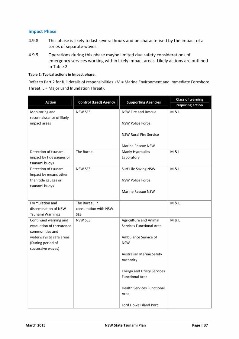
March 2015 NSW State Tsunami Plan Page | 37
Impact Phase
4.9.8 This phase is likely to last several hours and be characterised by the impact of a series of separate waves.
4.9.9 Operations during this phase maybe limited due safety considerations of emergency services working within likely impact areas. Likely actions are outlined in Table 2.
Table 2: Typical actions in Impact phase.
Refer to Part 2 for full details of responsibilities. (M = Marine Environment and Immediate Foreshore
Threat, L = Major Land Inundation Threat).
Action Control (Lead) Agency Supporting Agencies Class of warning
requiring action
Monitoring and
reconnaissance of likely
impact areas
NSW SES NSW Fire and Rescue
NSW Police Force
NSW Rural Fire Service
Marine Rescue NSW
M & L
Detection of tsunami
impact by tide gauges or
tsunami buoys
The Bureau Manly Hydraulics
Laboratory
M & L
Detection of tsunami
impact by means other
than tide gauges or
tsunami buoys
NSW SES Surf Life Saving NSW
NSW Police Force
Marine Rescue NSW
M & L
Formulation and
dissemination of NSW
Tsunami Warnings
The Bureau in
consultation with NSW
SES
M & L
Continued warning and
evacuation of threatened
communities and
waterways to safe areas
(During period of
successive waves)
NSW SES Agriculture and Animal
Services Functional Area
Ambulance Service of
NSW
Australian Marine Safety
Authority
Energy and Utility Services
Functional Area
Health Services Functional
Area
Lord Howe Island Port
M & L
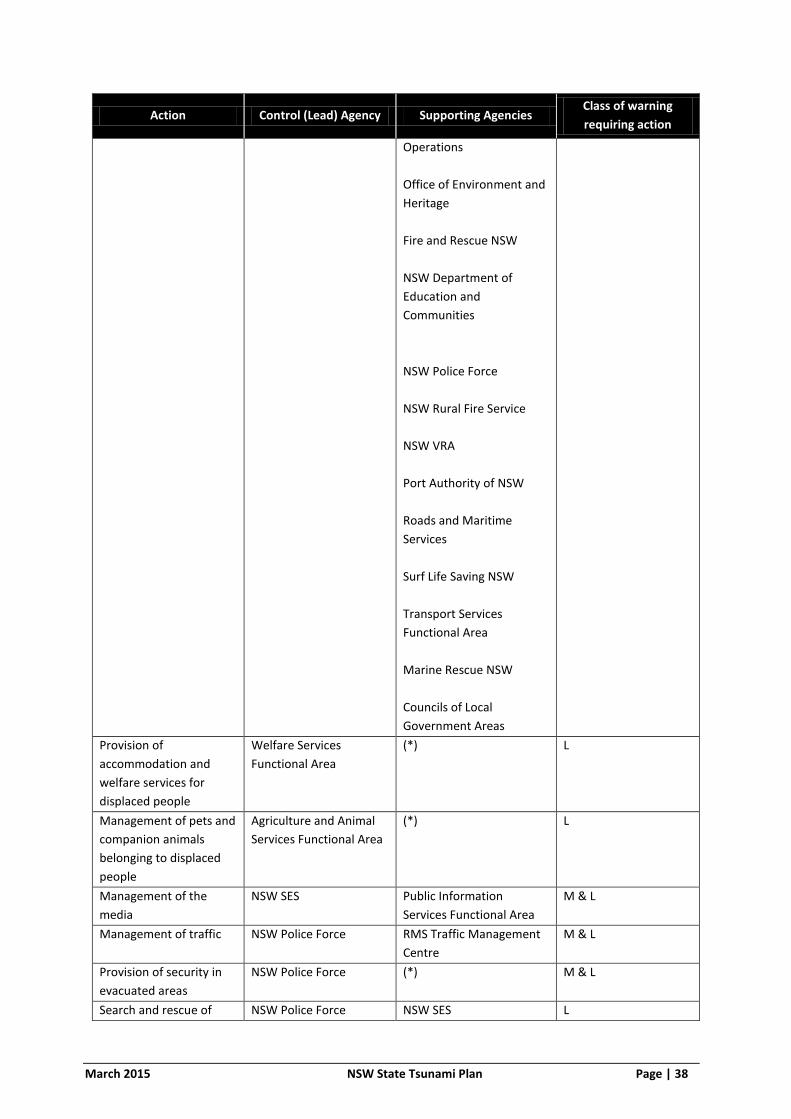
March 2015 NSW State Tsunami Plan Page | 38
Action Control (Lead) Agency Supporting Agencies Class of warning
requiring action
Operations
Office of Environment and
Heritage
Fire and Rescue NSW
NSW Department of
Education and
Communities
NSW Police Force
NSW Rural Fire Service
NSW VRA
Port Authority of NSW
Roads and Maritime
Services
Surf Life Saving NSW
Transport Services
Functional Area
Marine Rescue NSW
Councils of Local
Government Areas
Provision of
accommodation and
welfare services for
displaced people
Welfare Services
Functional Area
(*) L
Management of pets and
companion animals
belonging to displaced
people
Agriculture and Animal
Services Functional Area
(*) L
Management of the
media
NSW SES Public Information
Services Functional Area
M & L
Management of traffic NSW Police Force RMS Traffic Management
Centre
M & L
Provision of security in
evacuated areas
NSW Police Force (*)
M & L
Search and rescue of NSW Police Force NSW SES L

March 2015 NSW State Tsunami Plan Page | 39
Action Control (Lead) Agency Supporting Agencies Class of warning
requiring action
people trapped and
injured by the waves
destructive impact
Ambulance Service of
NSW
Fire and Rescue NSW
Marine Rescue NSW
Search and rescue of
people from the sea and
estuaries
NSW Police Force NSW SES
Surf Life Saving NSW
Marine Rescue NSW
M & L
(*) Note: Supporting agencies are not listed in this Plan for this specific action and will be nominated
by the lead agency for the action to be undertaken
Immediate Post-Impact:
4.9.10 This phase will commence upon the issue of a “Tsunami Warning Cancellation” indicating that the destructive potential of the tsunami has ceased. Likely actions are listed in table 3.
Table 3: Typical actions in Immediate Post-Impact phase.
Refer to Part 2 for full details of responsibilities. (M = Marine Environment and Immediate Foreshore
Threat, L = Major Land Inundation Threat)
Action Control (Lead) Agency Supporting Agencies Class of warning
requiring action
Formulation and
dissemination of NSW
Tsunami Warning
Cancellation advice,
indicating that the
destructive potential
of the tsunami has
ceased and it is safe
for emergency
services to enter the
impact area
The Bureau in
consultation with the
NSW SES
(*) M & L
Reconnaissance of
areas likely to have
been impacted
NSW SES Fire and Rescue NSW
NSW Police Force
NSW Rural Fire Service
Marine Rescue NSW
M & L
Search and rescue of
people trapped and
injured by the waves
NSW Police Force NSW SES
Ambulance Service of
L

March 2015 NSW State Tsunami Plan Page | 40
Action Control (Lead) Agency Supporting Agencies Class of warning
requiring action
destructive impact NSW
Fire and Rescue NSW
Marine Rescue NSW
Search and rescue of
people from the sea
and estuaries
NSW Police Force NSW SES
Marine Rescue NSW
Surf Life Saving NSW
M & L
Response to fire
incidents
Fire and Rescue NSW
(within Fire and
Rescue NSW
prescribed fire
districts)
NSW Rural Fire Service
(within NSW Rural Fire
Service prescribed fire
districts)
(*) L
Response to
hazardous materials
incidents
Fire and Rescue NSW (*) M & L
Likely to be limited for
Marine Environment
and Immediate
Foreshore Threat
Treatment of sick and
injured people
Health Services
Functional Area
Ambulance Service of
NSW
M & L
Provision of
accommodation and
welfare services for
displaced people
Welfare Services
Functional Area
(*) L
Likely to be limited for
Marine Environment
and Immediate
Foreshore Threat
Disaster victim
identification and
registration
NSW Police Force (*) M & L
Likely to be limited for
Marine Environment
and Immediate
Foreshore Threat
Provision and
coordination of
mental health support
to persons both
directly and indirectly
affected
Health Services
Functional Area
(*) L

March 2015 NSW State Tsunami Plan Page | 41
Action Control (Lead) Agency Supporting Agencies Class of warning
requiring action
Assessment of
potential public health
risks that either
acutely endanger the
health of human
populations or are
thought to have longer
term consequences
Health Services
Functional Area
(*) L
Disease control Health Services
Functional Area
(*) L
Management of pets
and companion
animals belonging to
displaced people
Agriculture and Animal
Services Functional
Area
(*) L
Management of a
public enquiry system
to provide basic
details on the location
and safety of victims
NSW Police Force (*) M & L
Damage control to
limit danger to the
public
NSW SES Engineering Services
Functional Area
Fire and Rescue NSW
NSW Rural Fire Service
Marine Rescue NSW
L
Provision of security
for supply lines and
evacuated and
damaged areas
NSW Police Force (*)
M & L
Resupply of
communities and
properties isolated by
tsunami impact
NSW SES NSW Rural Fire Service
NSW VRA
L
Damage Assessment NSW SES (*) M & L
Management of the
media
NSW SES Public Information
Services Functional
Area
M & L
Provision of public
safety advice
NSW SES (*) M & L
End of response
operations / All Clear
NSW SES M & L
(*) Note: Supporting agencies are not listed in this Plan for this specific action and will be nominated
by the lead agency for the action to be undertaken
March 2015 NSW State Tsunami Plan Page | 42
4.10 PUBLIC INFORMATION
Strategy
4.10.1 Gather and provide timely, relevant, accurate and tailored information to the community that support and encourage proactive measures to affected communities and relevant stakeholders.
Actions
4.10.2 The NSW SES will coordinate media and public information management strategies. During tsunami, the NSW SES operates a Public Information Unit with an on call media, social media, information and warnings and community liaison function.
4.10.3 The NSW SES operates an on call media officer system to deal with routine media management.
4.10.4 In the case of significant tsunami operations the NSW SES will establish and operate a Joint Media Information Centre (JMIC). This centre will coordinate the provision of all information to the media relating to the tsunami event. The NSW SES is responsible for setting up and equipping the unit.
4.10.5 Media Officers from all major participating agencies will be requested to staff the unit, which will be under NSW SES control.
4.10.6 The Public Information Services Functional Area will assist the NSW SES with establishment and operation of the Joint Media Information Centre.
4.10.7 If necessary the NSW SES will establish and operate a public enquiry centre or request the NSW Police Force to do so as detailed in the State EMPLAN.
4.11 WARNING DISSEMINATION
Strategy
4.11.1 Inform the community regarding the potential impacts of a tsunami and what actions to undertake in preparation for a tsunami.
Actions
4.11.2 When the NSW SES receives any information indicating the potential for risk to life and property from a tsunami, the need to protect life will be the highest priority.
4.11.3 Tsunami Watches and Warnings will be issued by the JATWC through the Bureau in consultation with the NSW SES, via the broadcast media.
4.11.4 Tsunami Warnings for NSW issued by the JATWC through the Bureau are intended to cover the entire NSW coast and will include only general instructions and safety advice (provided by the NSW SES) in a pre-agreed format. Separate warnings are also issued for Lord Howe Island.
4.11.5 The NSW SES and the Bureau will reach agreement on appropriate instructions and public safety advice before the release of Tsunami Watches and Warnings.
4.11.6 The State Emergency Operations Controller (SEOCON) and NSW SES State Operations Controller will communicate Tsunami Watches, Warnings and Bulletins

March 2015 NSW State Tsunami Plan Page | 43
issued by the JAWTC through the Bureau to agencies listed with responsibilities under this plan and the State EMPLAN. It is the responsibility of individual agencies once contacted to communicate Tsunami Watches, Warnings and Bulletins within their agency.
4.11.7 The NSW SES will direct the dissemination of Tsunami Watches and Warnings at regional and local levels, including evacuation warnings and orders. NSW SES local level arrangements will identify warning dissemination arrangements for individual communities.
4.11.8 To reduce the likelihood of conflicting information being provided to communities, local and regional NSW SES evacuation warnings or orders provided to media outlets will be coordinated by the relevant NSW SES Region Headquarters.
4.11.9 Evacuation warnings and orders issued by the NSW SES to specific communities will include the estimated time of arrival of the tsunami, the current situation, advice on what to do before evacuating, when to evacuate, the location of evacuation centres and what to take to evacuation centres, as well as general safety advice.
4.11.10 The NSW Police Force Marine Area Command will coordinate the dissemination of Tsunami Watches, Warnings and Bulletins issued by the JATWC through the Bureau to commercial and recreational vessels via marine radio distress and calling frequencies, through search and rescue coordination centres operated by Marine Rescue NSW.
4.11.11 Methods of dissemination may include the following:
a. Radio and television broadcasts, preceded by the Standard Emergency Warning Signal (SEWS). The decision to use SEWS to precede a tsunami warning will be made by the NSW SES. Television broadcasts will utilise the Channel NSW digital TV network.
b. Doorknocking (only when safe to do so)
c. Emergency Alert (SMS and/or voice to mobile and/or landline)
d. Sirens
e. Mobile and Fixed Public Address Systems
f. Telephone and Fax
g. Low flying aircraft equipped with public address systems.
h. Two-way radio
i. Marine Satellite Phone
j. Variable Message Signs
k. Internet via the Bureau website www.bom.gov.au and Emergency NSW website www.emergency.nsw.gov.au
l. Social Media
m. Marine Rescue Vessel public address systems
n. Public marine radio channels (ie. VHF)

March 2015 NSW State Tsunami Plan Page | 44
4.11.12 A “Warning Cancellation” message will be issued by the JATWC through the Bureau in consultation with the NSW SES after confirmation that destructive impacts will not eventuate from a tsunami or after confirmation that a tsunami event has ended, and the coastal area is safe for emergency services to enter the impact area to commence immediate post impact response operations. It is important to note a tsunami is not a single wave, but a series of waves with destructive potential which may last several hours.
4.11.13 Flow charts of warning dissemination are shown in Figures 6 and 7. These charts detail the warning transmission from warning centres to marine and land based risk groups.
4.11.14 A summary table detailing elements potentially requiring warning, agencies responsible for warning and possible warning methods is detailed in Table 8.
4.12 INFORMATION MANAGEMENT
Strategy
4.12.1 Collect, collate, analyse, map and distribute information relating to tsunami operations.
Actions
4.12.2 All participating agencies will accurately record and report information relevant to their activities to the appropriate NSW SES control facility. Information will then be distributed by the NSW SES.
4.12.3 The NSW SES State Headquarters will provide operational updates to all agencies listed under this plan and to all state level supporting operations centres. These operational updates are to detail activities of supporting agencies.
4.12.4 The NSW SES if needed will establish and operate a Joint Mapping Unit to coordinate the collection, collation, analysis, mapping and distribution of geospatial information. Products from this group will be disseminated to the JMIC, SEOC and other agencies involved in the response and recovery operations. GIS Officers from supporting agencies will be requested to staff the group.
4.13 RECONNAISSANCE
Strategy
4.13.1 Conduct reconnaissance to assess the extent of tsunami inundation and the resulting damage.
Actions
4.13.2 NSW SES is to coordinate monitoring and reconnaissance of coastal areas.
4.13.3 Aerial reconnaissance is likely to be the most efficient and effective method.

March 2015 NSW State Tsunami Plan Page | 45
4.14 DAMAGE CONTROL
Strategy
4.14.1 Conduct damage control operations In the immediate post impact period to limit danger to the public.
Actions
4.14.2 In the immediate post impact period there may be some scope for action to be taken to limit danger to the public. This activity will only be undertaken when it does not conflict with rescue and recovery priorities. Damage control tasks may include:
a. Removal of dangerous debris and shoring up of structures to reduce danger to the public; and
b. Tarping of structures to prevent the ingress of rainwater.
4.14.3 Damage control operations will be coordinated by the NSW SES.
4.14.4 Damage control operations will not include any restoration or reconstruction tasks.
SUPPORTING SERVICES AND ASSISTANCE
4.15 DISASTER WELFARE
Strategy
4.15.1 Maintain the welfare of communities and individuals affected by the impact of a tsunami.
Actions
4.15.2 The Welfare Services Functional Area will manage evacuation centres for affected residents and travellers in accordance with the NSW Evacuation Management Guideline. The SEOCON rather than Welfare Services Functional Area will manage Major Evacuation Centres where they are established.
4.15.3 The Welfare Services Functional Area is to activate the Welfare Services Functional Area Supporting Plan if required to coordinate disaster welfare services to communities affected.
4.15.4 The NSW SES will provide immediate welfare for evacuees where required but will hand this responsibility over to the Welfare Services Functional Area as soon as possible. In the event of a Major Evacuation Centre being required, assist the SEOCON in the management of the centre.
4.15.5 Details of all residents assisted must be made available to the Welfare Services Functional Area as early as possible so that they can provide any required follow up.
March 2015 NSW State Tsunami Plan Page | 46
4.16 DISASTER VICTIM IDENTIFICATION AND REGISTRATION
Strategies
4.16.1 Identify dead and injured persons and notify next of kin.
4.16.2 Manage a disaster victim registration and a public inquiry and information centre.
Actions
4.16.3 NSW Police Force as detailed in the State EMPLAN are responsible for managing the identification of the dead and injured, notifying next of kin, establishing temporary mortuaries, coordinating disaster victim registration and operation of a public inquiry and information centre.
4.17 MANAGEMENT OF ENERGY AND UTILITIES
Strategy
4.17.1 Ensure coordinated management of Energy and Utilities Infrastructure.
Actions
4.17.2 The Energy and Utility Services Functional Area will keep the NSW SES informed of the status of energy and utilities infrastructure when a Tsunami Watch or Warning is current.
4.18 MANAGEMENT OF ENGINEERING SUPPORT
Strategy
4.18.1 Ensure coordinated management of Engineering Resources
Actions
4.18.2 The Engineering Services Functional Area will provide coordination of engineering resources. This will include the coordination of engineering resources for the removal of debris, in particular to re-establish access to enable response operations to be undertaken.
4.19 HEALTH RESPONSE
Strategy
4.19.1 Ensure coordinated health services are available to and accessible by tsunami affected communities.
Actions
4.19.2 The Health Services Functional Area will:
a. Activate HealthPlan if required.
b. Health Services Functional Area Coordinator to activate Health Services Disaster Coordination Centre if required.
c. Treat sick and injured people, including the provision of pre-hospital care and transport by Ambulance Services of NSW.

March 2015 NSW State Tsunami Plan Page | 47
d. Provide and coordinate immediate mental health support to persons both directly and indirectly affected.
e. Assess public health risks.
f. Provide environmental health advice.
4.19.3 All matter relating to the primary production, manufacturing, processing and handling of all food from “paddock/ocean” to retail, inclusive of all restaurants, food services and catering businesses should be referred to the NSW Food Authority through the Agriculture and Animal Services Functional Area.
4.19.4 The Health Services Functional Area is to activate Healthplan if required.
4.20 MANAGEMENT OF ANIMALS
Strategy
4.20.1 Maintain the welfare of animals affected by the impact of a tsunami.
Actions
4.20.2 Matters relating to the welfare of livestock, pets, companion animals and wildlife (including feeding and rescue) are to be referred to the Agriculture and Animals Services Functional Area.
4.20.3 Agricultural Services Functional Area Coordinator is to activate the Agriculture and Animal Services Supporting Plan if required to provide assistance with livestock, pets, companion animals and wildlife.
4.21 TELECOMMUNICATIONS
Strategy
4.21.1 Maintain communication systems to ensure operational effectiveness.
Actions
4.21.2 NSW SES uses the Australian Telecommunication Carrier Networks as the primary means of communication rather than radio between units and above that level, provided telephone services are operating.
4.21.3 The NSW SES operates on the Government Radio Network (GRN) where it provides coverage and on Ultra High Frequency Private Mobile Radio (UHF PMR) systems elsewhere in the frequency range of 450-470 MHz.
4.21.4 The NSW SES utilises email, fax and intranet.
4.21.5 Supporting agencies are expected to utilise their own internal communications systems when supporting NSW SES tsunami operations. The NSW SES will provide linking communications as necessary.
4.22 MANAGEMENT OF TRANSPORT
Strategy
4.22.1 Ensure coordinated management of transport resources.

March 2015 NSW State Tsunami Plan Page | 48
Actions
4.22.2 The Transport Services Functional Area will keep the NSW SES informed of the status of transport infrastructure when a Tsunami Watch or Warning is current.
4.22.3 The Transport Services Functional Area is to activate the Transport Services Functional Area Supporting Plan if required.
4.23 FIRE AND HAZARDOUS MATERIALS
Strategy
4.23.1 Protect the community from incidents involving fire and hazardous materials
Actions
4.23.2 Fire and Rescue NSW and the NSW Rural Fire Service will monitor identified facilities (see 3.8) and respond to fire incidents.
4.23.3 Fire and Rescue NSW will monitor identified facilities (see 3.8) and control hazardous materials incidents occurring on land or in inland waters and activate the Hazmat/CBRN Plan if required.
4.23.4 The Port Authority of NSW, Roads and Maritime Services and Transport for NSW will respond to marine oil and chemical spill incidents within State waters as detailed in the NSW Marine Oil and Chemical Spill Contingency Plan if required.
4.23.5 The Environmental Services Functional Area is to implement the Environmental Services Functional Area Supporting Plan (Enviroplan) if required.
4.24 DEFENCE ASSISTANCE
4.24.1 Arrangements for defence assistance to the civil community are contained within State EMPLAN.
OPERATIONS
4.25 COMMUNICATIONS
Strategy
4.25.1 Maintain communication systems throughout tsunami operations.
Actions
4.25.2 The NSW SES uses the Public Switched Telephone Network (PSTN) as the primary means of communication between State, Region and Unit Operations Centres, provided telephone services are operating.
4.25.3 The NSW SES also uses terrestrial cellular telephone and satellite telephone networks as supplements to the PSTN.
4.25.4 The NSW SES operates on the Government Radio Network (GRN) where it provides coverage and on Ultra High Frequency Private Mobile Radio (UHF PMR) systems elsewhere in the frequency range of 450-470 MHz.

March 2015 NSW State Tsunami Plan Page | 49
4.25.5 The NSW SES uses the internet for transfer of operational communications and transfer of information.
4.25.6 Supporting emergency services and functional areas are expected to utilise their own internal communications systems when supporting the NSW SES in tsunami operations. When possible, the NSW SES will provide linking communications as necessary.
4.25.7 All liaison officers will provide their own communication links back to their parent organisations.
4.25.8 All other organisations will provide communications as necessary to their deployed field teams.
4.26 EVACUATION
Strategy
4.26.1 Evacuate people pre-emptively from dangerous or potentially dangerous places created by the tsunami hazard to safe locations away from the hazard
Actions
4.26.2 Evacuations will take place in areas where a tsunami poses risk to public safety.
4.26.3 Evacuation and closure of beaches and direct waterfront areas of harbours, estuaries and rock platforms within specified coastal waters areas will be required on receipt of a Tsunami Warning indicating a threat to the marine environment and immediate foreshore areas.
4.26.4 Evacuation of low-lying coastal land areas within specified coastal waters areas will be required on receipt of a Tsunami Warning indicating a major land inundation threat.
a. People will be instructed to move from low-lying coastal and tidal river areas to high ground at least 10 metres above sea level and 1 kilometre away from the waters edge. If no high ground is available nearby, people will be instructed to move as far away from the coast and tidal river areas as possible and to stay there until advised that it is safe to return. The upper floors of rigid multi-story buildings may provide refuge if there is no time available to evacuate or people become trapped.
4.26.5 People on boats or ships will be encouraged to undertake (note these actions are appropriate to both levels of threat, marine threat and land inundation threat):
a. If in shallow water return to land, secure vessel and move to high ground. If no high ground is available nearby move as far away from the coast and tidal river areas as possible. Stay there until advised that it is safe to return.
b. If in deep water stay there until advised it is safe to enter ports and harbours.
c. If close to deep water, move to deep water and stay there until advised it is safe to enter ports and harbours.
March 2015 NSW State Tsunami Plan Page | 50
4.26.6 Specific risk areas requiring evacuation and the arrangements for these areas are to be detailed in NSW SES local level arrangements.
4.26.7 When unusual ocean behaviour indicative of tsunami is observed locally, or a large seismic event with the potential to generate tsunami is experienced, evacuation should be immediately initiated at the local level.
4.27 PROTECTION AND PRE-DEPLOYMENT OF ESSENTIAL RESOURCES
Strategy
4.27.1 Where sufficient warning time is available essential resources required to respond to the impacts of tsunami will be protected.
Actions
4.27.2 Resources from outside likely impact areas when available may be pre-deployed close to likely impact areas.
4.27.3 Land and marine resources required to deal with the effects of a tsunami impact will be protected by removing them to locations outside the likely impact area. For land based resources this will mean moving to high ground outside the potential impact area when land inundation is anticipated. It is unlikely that there will be time available to undertake the protection of marine resources when required by moving them to deep water outside bays, harbours and estuaries. Marine resources must therefore be appropriately secured or if trailable, trailed and moved to high ground outside the potential impact area.
4.27.4 In addition other resources may need to be pre-deployed to staging areas outside the likely impact area, in particular if NSW Tsunami Warnings warn of a land inundation threat.
4.27.5 To avoid the potential for conflict created by the removal of resources essential for warning and evacuation the NSW SES will specify the timing of protection and pre-deployment activities.
4.28 RESTORATION OF ESSENTIAL UTILITIES
Strategy
4.28.1 Minimise disruption to the community by re-establishing essential energy and utility services.
Actions
4.28.2 Energy and Utility Services Functional Area Coordinator to coordinate the restoration of essential energy and utility services.
4.28.3 Electricity network operators are responsible for prioritising the restoration of supply in the following sequence:
a. High Voltage (HV) network
b. Low Voltage (LV) network feeders supplying health and related utilities and critical facilities

March 2015 NSW State Tsunami Plan Page | 51
c. LV network feeders supplying other customers
4.28.4 The Telecommunications Services Functional Area Coordinator will coordinate the restoration of telecommunication services to the community.
4.28.5 The Engineering Services Functional Area will coordinate the restoration of critical public buildings (for example hospitals).
4.29 RESUPPLY OF ISOLATED COMMUNITIES
Strategy
4.29.1 Minimise disruption upon the community by resupplying towns, villages and/or properties which have become isolated as a consequence of the impact of a tsunami.
Actions
4.29.2 The NSW SES is responsible for the coordination of resupply operations.
4.29.3 Resupply operations will be conducted in accordance with arrangements set out in NSW SES Flood Plans.
4.30 RE-ESTABLISHMENT OF ACCESS
Strategy
4.30.1 Minimise disruption upon the community by re-establishing access to properties, dwellings and impact areas.
Actions
4.30.2 Remove fallen trees blocking roads.
4.30.3 NSW SES to coordinate the re-establishment of access.
4.30.4 Local Government Councils to coordinate the clearance of debris from Council managed roads and public land including beaches.
4.30.5 Roads and Maritime Services (RMS) coordinate the clearance of debris from RMS managed roads.
4.30.6 Engineering Services Functional Area can provide assistance with the coordination of this task.
4.31 RESTRICTION OF ACCESS AND SECURITY
Strategy
4.31.1 Given the serious risk to life and the need to provide security for evacuated areas, access to the coastal zone should be restricted to all but authorized personnel when a NSW Tsunami Warning is current.
Actions
4.31.2 The NSW Police Force will assist the NSW SES in restricting access to areas at-risk during a tsunami event. Priority will be given to restricting access to waterfront locations in urban areas.

March 2015 NSW State Tsunami Plan Page | 52
4.31.3 The NSW Police Force will coordinate the security of supply lines and evacuated and damaged areas.
4.32 MANAGEMENT OF WATERWAYS
Strategy
4.32.1 Vessels may be instructed to relocate to minimise the potential for tsunami
damage.
Actions
4.32.2 The safety of ocean capable vessels and their crew is dependent upon water depth and distance from shore. As a general principle vessels will be safer the further they are from the coastline and the deeper the water they are in.
4.32.3 When sufficient warning time is available ocean capable vessels may be instructed to move to deep water offshore. Vessels instructed to move from ports or harbours to deep water offshore will be prioritised in terms of risk posed to the nearby port facilities and population and their potential to provide assistance during rescue and recovery phases. It may be difficult for smaller vessels to move to deep water if there is a concurrent severe weather event occurring or predicted. Port Authorities will coordinate the movement of ships from ports to deep water offshore.
4.32.4 Up to 3 hours before the predicted arrival time of a tsunami, access will be allowed to moored boats to enable removal of valuables and securing of boats.
4.32.5 Given the risk to life and conflict with evacuation operations when insufficient warning time is available, access will not be allowed to waterways to remove trailerable boats.
4.32.6 Large ships at sea will be instructed to remain offshore in deep water.
4.33 SEARCH AND RESCUE
Strategy
4.33.1 Coordinate search and rescue of people from collapsed buildings, waterways and the ocean during and after tsunami impact.
Actions
4.33.2 Land search, inland waterway and underwater search and recovery, and marine search and rescue will be controlled and coordinated by the NSW Police Force.
4.33.3 Flood rescue, including flooding from tsunami inundation, will be controlled and coordinated by NSW SES.
4.33.4 To assist with search and rescue, the NSW SES will ensure that the NSW Police Force are aware of all current Tsunami Watches and Warnings and any reports of tsunami impact.

March 2015 NSW State Tsunami Plan Page | 53
4.33.5 The NSW Police Force is to keep the NSW SES State Operations Centre informed of the progress of search and rescue operations and the requirements for rescue resources.
4.33.6 The SEOCON will activate the Major Structural Collapse Sub Plan if required.
4.34 REQUESTS FOR ASSISTANCE
Strategies
4.34.1 The NSW SES maintains an Emergency Assistance line 132 500. The community is encouraged to call this number to request assistance following the impact of a tsunami.
4.34.2 The NSW SES operates a Request for Assistance management system. This is a computer based system that is used to log calls from those seeking assistance with tsunami damage.
4.34.3 The NSW SES has an Operations Centre based at its State Headquarters located in Wollongong. This Operations Centre operates 24 hours a day 7 days a week (24/7).
Actions
4.34.4 All calls taken by the NSW SES 132 500 system are automatically directed to the relevant NSW SES Unit The 132 500 system automatically directs calls to the relevant local NSW SES unit.
4.34.5 The NSW SES Operations Centre is to monitor call statistics for the 132 500 system and will manage the re-distribution of calls to any number of selected answer points as required. The NSW SES 24x7 Operations Centre is to monitor call statistics relating to the 132 500 system and will manage the re-distribution of calls to any number of different answer points, including the call taking centre based in the 24x7 Operations Centre if required.
4.34.6 Details of calls for assistance made to the Police and other emergency services, either via the 000 system or direct, should be sent electronically to the NSW SES Operations Centre. Details of calls for assistance made to Police and the other emergency services, either via the ‘000’ system or direct, should be sent by electronic means to the State NSW SES 24x7 Operations Centre.
4.34.7 Life threatening calls which are taken by other emergency services should be responded to, if possible, and the NSW SES Operations Centre advised.
4.34.8 The following details must be passed onto the NSW SES by other agencies which respond directly to calls for assistance received from the public:
a. Names of occupants;
b. Address of damaged buildings;
c. Telephone number;
d. Whether the task has been completed; and
e. A general description of the task and the action taken.

March 2015 NSW State Tsunami Plan Page | 54
4.35 LIAISON
Strategy
4.35.1 Effective liaison is to be established between the NSW SES and supporting agencies.
Actions
4.35.2 Supporting emergency services and functional areas are to be prepared to provide liaison officers to NSW SES State, Region and Local headquarters as required. A Liaison Officer maintains communications with and conveys directions/requests to their organisation or functional area, and provides advice on the status, capabilities, actions and requirements of their organisation or functional area. It will not always be necessary for liaison officers to be deployed if reliable communications are available between the NSW SES Incident Controller and the commanders of the supporting agencies. The decision rests with the NSW SES State Controller.
4.36 LOGISTICS
Strategy
4.36.1 Coordinate logistics support to ensure operational effectiveness.
Actions
4.36.2 If local NSW SES and other local resources are insufficient or likely to be exhausted, additional NSW SES resources may be deployed by the appropriate NSW SES Region Headquarters. If further NSW SES resources are required from other Regions they will be deployed by the NSW SES State Headquarters.
4.36.3 Support resources may be requested directly from other agencies by the NSW SES or via requests to EOCON’s.
4.36.4 The NSW SES will provide consumable operational stores such as tarpaulins, rope and plastic.
4.36.5 Vehicle and chainsaw generator fuel will be coordinated by the NSW SES through normal retail outlets.
4.36.6 The NSW SES will coordinate the acquisition and utilisation of major equipment such as cranes, cherry pickers and front-end loaders unless specifically authorised separately.
4.36.7 The NSW SES may engage commercial tree lopping contractor and companies to assist with damage response tasks.
4.36.8 The NSW SES may engage electricians to assist with disabling photovoltaic arrays, where large scale damage inhibits effective response.
4.36.9 The NSW SES may engage companies specialised in the handling of asbestos, where large scale damage inhibits effective response.

March 2015 NSW State Tsunami Plan Page | 55
4.37 ALL CLEAR AND RETURN
Strategy
4.37.1 Coordinate the safe return of communities to tsunami affected areas when the immediate danger to life and property has passed.
Actions
4.37.2 There are two circumstances where the issue of an All Clear will be required.
a. When a “Warning Cancellation” is issued by JATWC to confirm that the destructive impacts of a warned tsunami will not eventuate and it is safe to return to potential impact areas. The NSW SES will consult with JATWC through the Bureau’s NSW RFC.
b. When following the impact of a destructive tsunami it has been assessed that evacuees can return to impacted areas. The Recovery Coordinator will issue a notification.
4.37.3 The ability for residents and businesses to return in a safe environment will be determined by a number of considerations including:
a. Cleaning of power poles, wires and street transformers prior to re-energising of power lines;
b. Electrical safety checks of houses and buildings, prior to reconnection;
c. Gas line purging and re-lights of household services;
d. Sewer services cleaned and reconnected subject to service availability of the street mains; and
e. Water supply purged and subject to service availability of the street mains.
f. Assessment of any damage to roads and bridges
g. Assessment of hazardous materials in buildings or on thoroughfares.
h. Assessment of public health concerns.
4.37.4 The NSW SES will assess, in consultation with the relevant EOCON and SERCON, each area affected and specify the level of access as one of the following:
a. Not suitable for access;
b. Limited access by emergency services and response agencies; or
c. Limited access by residents and/or business operators.
4.37.5 When the immediate danger to life and property has passed the relevant NSW SES Controller will issue an 'All Clear' message for areas when recovery operations have commenced or full access is safe. However, declaring an ‘All Clear’ may take an extended amount of time.
4.37.6 Note that before any All Clear is issued subsequent to the cancellation of a Tsunami Warning a damage assessment will be required to ensure that it safe for people to return.
4.37.7 Response impact assessment will inform the recovery impact assessment.
March 2015 NSW State Tsunami Plan Page | 56
4.37.8 Debriefs will be conducted as soon as possible after the end of response operations.
4.37.9 Response operations will conclude once all of the following conditions have been met:
a. Physical tsunami impact has ceased.
b. The need for warning and evacuation no longer exists.
c. There is no further prospect of rescuing people trapped by the tsunami waves or their destructive impacts
d. Response to fire and hazardous material incidents have concluded (not including subsequent clean-up of contaminated sites).
4.38 AFTER ACTION REVIEWS
Strategy
4.38.1 After Action Reviews are to be undertaken following each event.
Actions
4.38.2 Undertake After Action Reviews involving all stakeholders to consider the effectiveness of prevention and preparedness activities and response and recovery operations.
4.38.3 Findings from significant events are broadly shared and incorporated into improved disaster resilience planning.

March 2015 NSW State Tsunami Plan Page | 57
PART 5 - RECOVERY
5.1 RECOVERY OPERATIONS
5.1.1 This plan describes the initiation of recovery, but not the arrangements for recovery itself.
5.1.2 Recovery operations will be initiated and conducted as described in the NSW State Emergency Management Plan (EMPLAN) Part 9 and as further detailed in the NSW Recovery Plan.
5.1.3 Recovery includes the process of returning affected communities to their proper level of functioning after a tsunami.
5.1.4 There will often be a need for emergency services to assist in the recovery phase of a tsunami operation. This can involve physical clean-up or maintenance of temporary coverings.
5.1.5 Preparation for recovery will begin during the pre-impact phase. Recovery operations will begin concurrently with impact period response operations.
5.1.6 NSW SES will provide impact information as early as possible (ideally within 24 hours) following a tsunami to the SEOCON or delegated Emergency Operations Controller to inform an initial recovery impact assessment.
5.1.7 NSW SES will provide appropriate representation to the Recovery Committee, if established, for the duration of the response phase of an event and as agreed during the recovery phase.
5.1.8 The role of NSW SES on the Recovery Committee may include providing information about any continuing response, guidance on mitigation strategies and general advice and assistance to the committee as a subject matter specialist.
5.1.9 Where the maintenance of tarpaulins will be required over a protracted period, the NSW SES may request the Engineering Services Functional Area to undertake this work.

<IMAGE REMOVED IN RTF VERSION – NSW State Emergency Service Logo>
TSUNAMI HAZARD AND RISK
IN NEW SOUTH WALES
Volume 2 of the NSW State Tsunami Plan
March 2015
<IMAGE REMOVED IN RTF VERSION – Tsunami Safe Logo>

March 2015 NSW State Tsunami Plan Page | 59
PART 6 - GENERAL
6.1 WHAT IS A TSUNAMI?
6.1.1 A tsunami is a series of ocean waves generated by a sudden displacement of large volumes of water. Tsunami may be caused by any one or combination of the following:
a. Vertical movement of the sea floor as a result of a large earthquake.
b. Sub-marine or coastal volcanic eruptions.
c. Meteor impacts.
d. Coastal landslides and slumps, either land-based or sub-marine (10).
6.1.2 Arrival: Natural warning signs of tsunami may be provided by:
a. Ground shaking – this may be felt prior to a tsunami due to an earthquake
b. Ocean withdraw – the sea may appear to retreat from the coastline before returning with the first crest of a tsunami
c. Roaring sounds – noise may be heard with tsunami wave arrival (11).
6.1.3 Behaviour: Tsunami usually involve multiple waves. The first wave may not be the largest. Tsunami can wrap around headlands or islands and damage coasts on the lee-side that faces away from the source of the tsunami. Tsunami impacting on harbours and bays can create damaging wave activity and currents. (10).
6.1.4 Inundation and Run-up: Tsunami inundation is dependent on the configuration of the coastline, the shape of the ocean floor, reflection of waves, tides and wind waves. Narrow bays, inlets and estuaries may cause funneling effects that increase the inundation area. The combination of these factors means that the inundation produced by a tsunami can vary greatly from place to place over a short distance. It also means the predicting the extent of inundation is very difficult. Run-up is defined as the highest point (maximum elevation) that becomes inundated by the tsunami.” (10).
6.1.5 Speed and Height: Tsunami speed is dependent on water depth and wave period. In deep water and in the open ocean, tsunami waves can reach speeds of 900 kilometres per hour (12). Heights of tsunami waves in deep water are only slight and may go unnoticed by marine vessels. Tsunami waves increase in size and reduce speed as they approach the shore (known as shoaling). The first wave in the series may not be the largest (10).
6.1.6 Wave length: Tsunami waves are characterised by their long wave length, which may be up to hundreds of kilometres between the wave crests (12).
6.1.7 Wave period: Wave period (or time between wave crests) is dependent upon the mode of propagation (relative velocity and magnitude of the disturbance, the water depth in which the wave is generated and the volume of water displaced by the event generating the waves). The wave period is usually lasts between a few minutes to a few hours (10) (12).

March 2015 NSW State Tsunami Plan Page | 60
6.1.8 Wave type: Tsunami waves involve movement of all water from the seabed to the surface and differ to wind waves which only move the surface of the water (12).
6.2 TSUNAMI GENERATION
6.2.1 Earthquakes are the most common cause of tsunami (12). However, not all earthquakes generate tsunami. To generate a tsunami, the fault where the earthquake occurs must be underneath or near the ocean, and the earthquake must cause significant vertical movement of the sea floor over a large area. Shallow-focus earthquakes along tectonic plate subduction zones are responsible for the most destructive tsunami. (10)
6.2.2 Tsunami can be classified as either, local, regional or distant, depending on the distance of their generation from the coastline (10).
a. Local tsunami (near-field) are generated close to the affected coast. Time between generation and arrival at the coast can be as little as five minutes, hence it is unlikely that areas at the initial point of impact would receive any effective warning other than environmental signals, such as strong ground shaking or drawdown at the coastline. In Australia, no local tsunami have been observed since European settlement. Local tsunami may be generated by submarine or coastal landslides occurring close to the NSW coast. Evidence indicating the existence of previous submarine landslides has been found on the continental shelf offshore of the NSW coast.
b. Regional tsunami are those generated within the south west Pacific. Potential regional tsunami sources are located in subduction zones along the Indian-Australian and Pacific tectonic plate boundary which runs through Macquarie Island, New Zealand, Tonga, Vanuatu, Papua New Guinea, the Solomon Islands and the Kermadec Islands.
c. Distant tsunami (far-field) are generated far away from the affected coastline. NSW may be affected by tsunami generated by subduction zone boundaries as far away as North America, South America and Asia or divergent boundaries located between Australia and Antarctica.
6.3 TSUNAMI IMPACT
6.3.1 Destruction from tsunami is the direct result of: inundation, waves, erosion and debris impact on coastal structures. Floatation and drag forces can move buildings and over-turn vehicles. Tsunami associated wave forces can demolish buildings. Considerable damage is also caused by debris, including boats, up-rooted vegetation, structural materials, cars and other vehicles that are swept along by the force of the water. Even small tsunami can generate currents strong enough to cause damage to boats and associated facilities. Destructive waves may continue for a number of hours and several days may pass before the sea returns to its normal state (10).

March 2015 NSW State Tsunami Plan Page | 61
PART 7 - NEW SOUTH WALES TSUNAMI HAZARD
7.1 NSW TSUNAMI SOURCES
7.1.1 Tsunami are known to be generated by vertical movement of the sea floor as a result of a large earthquake; sub-marine or coastal volcanic eruptions; meteor impacts; or coastal landslides and slumps, either land-based or sub-marine (10).
7.2 EARTHQUAKE SOURCES
7.2.1 The majority of tsunami are caused by earthquake-induced displacement of the seafloor typically along subduction interface plate boundaries. This includes the world’s largest tsunami, including the Mw 9.5 1960 Chile earthquake, the Mw 9.2 1964 Alaska earthquake, the Mw 9.1 Sumatra–Andaman Islands earthquake of 26 December 2004 and the Mw 9.0 Japan earthquake of 11 March 2011. Smaller earthquakes can cause significant tsunami as well, however their impact tends to be more localised (13) (14).
7.2.2 At ARIs of above 500 years (unlikely events) only a few potential earthquake sources contribute to the tsunami hazard in NSW. These sources include the regional plate boundaries of the New Hebrides (Vanuatu), Kermadec and Puysegur trenches. This is because only a few sources can generate tsunami having a large near shore wave amplitude. At an ARI of less than 100 years (possible events) however, many potential sources contribute to the tsunami hazard in NSW. These include both regional and distant plate boundaries and include the regional subduction zones off New Hebrides (Vanuatu), Kermadec and Puysegur, as well as distant sources off Peru, Chile and Indonesia (14).
7.3 VOLCANO SOURCES
7.3.1 There are at least five active volcanoes capable of generating a tsunami that could affect Australia however, the Krakatau eruption of 26–27 August 1883 is the only documented eruption to have generated a tsunami that affected Australia and is recorded in the NSW record. It caused 36,000 deaths in Indonesia and generated a tsunami in the Indian Ocean that was more extensive than the 2004 Indian Ocean tsunami (14).
7.4 LANDSLIDE SOURCES (LAND AND SUBMARINE)
7.4.1 Submarine slides are also a source for tsunami although their effects tend to be more localised. It is worth noting however, that major submarine slides (e.g. in Hawaii) can generate giant tsunami that could devastate coastal regions thousands of kilometres away. Off the NSW coast numerous submarine slide scars can be seen on the continental slope, with several significant ones lying adjacent to Sydney (14).
7.4.2 One of the largest slides occurred off Bulli and was 10km wide and 20km long and is considered large enough to have generated a significant local tsunami (14). Clarke et al. (2014) undertook morphologic characterisation of five distinct, eastern Australian upper continental slope submarine slides and modelling of their

March 2015 NSW State Tsunami Plan Page | 62
tsunami hazard (15). Their analysis suggests that the reoccurrence of submarine slides with similar characteristics to those shed from the margin in the geologically recent past would be expected to generate tsunami with maximum flow depths between 5 and 10m at the coastline, run-up of up to 5m and inundation distances of up to 1km (14).
7.5 ASTEROID SOURCES
7.5.1 Tsunami can also be generated by asteroid strike impact on the ocean, and although there are no known examples during human history, there is geological evidence of ocean impacts from asteroid-tsunami. For example, there is evidence to suggest that a 1km or larger object, the Eltanin asteroid, impacted the Southern Ocean circa 2.15 Ma (mega annum) (14).
7.5.2 Probabilistic modelling undertaken in the year 2000, extrapolated to NSW indicates the return period for an asteroid generated tsunami with a wave amplitude of 1m at a water depth of 15m is approximately one thousand years (unlikely). However, several other recent studies suggest this may be too frequent and an ARI for an event this size may be more likely to be around 10,000 years (rare) (14).
7.6 TSUNAMI HISTORY
7.6.1 The NSW coast has experienced some 44 tsunami since European settlement, many which have been too small to produce noticeable effects. Since 2007 four tsunami events have been observed to impact on NSW including tsunami originating from earthquakes off the Solomon Islands, New Zealand, Chile and Japan (16).
7.6.2 The maximum run-up for a historical tsunami was 1.71m at Eden which was generated from the Chilean earthquake in 1960 (17). Damage was limited primarily to vessel moorings, although the oyster industry did suffer some losses. There were two unconfirmed reports of minor injury and some reports of people having to flee beaches and tidal rock shelves indicating that the tsunami did create a risk to life along the coast of NSW (17).
7.6.3 Historic records indicate that the Black Sunday event of February 1938 at Bondi produced a number of large waves in quick succession. Reports at the time showed around 250 people required assistance with 35 near drowning’s and 5 fatalities (18). Waves were also reported on adjacent beaches and as far north as Newcastle. There is a suggestion that this event may have been a tsunami generated by a localised submarine landslide, however this has not been verified. (11)
7.6.4 Geological studies (14) also suggest tsunami impact along the NSW coast with seven events documented with the oldest event dated at 105 ka (kilo annum) BP (before present) and reported to have been generated by submarine sediment slides off Lanai, Hawaii. The six youngest paleo-tsunami events all occurred during the Holocene (10,000 years ago to the present). The causes of these other six events are unknown. The maximum run-up for a paleo-tsunami is reported at possibly as much as +130 m above sea level at Steamers Beach, Jervis Bay, while

March 2015 NSW State Tsunami Plan Page | 63
another event is reported to have inundated the coast to distances of 10 km inland. Some scientists have begun to question the evidence reported for these events. Most recently, one of the key sites for a paleo-mega tsunami deposit has been re-examined (at Minnamurra Point, Kiama), finding that the proposed tsunami deposited sediments were an in-situ soil horizon. Further work is required to examine the paleo-tsunami record in order to check the accuracy of the paleo-tsunami record (14).
7.7 TSUNAMI HAZARD ASSESSMENT
7.7.1 In 2008 Geoscience Australia completed an Offshore Probabilistic Tsunami Hazard Assessment (OPTHA). The OPTHA estimated the likelihood of a tsunami wave of a given height occurring at offshore locations (at 100m water depth). Results indicated that the highest offshore hazard is in the northwest of WA. Offshore hazard on the eastern and northern coasts of Australia is significantly less than the northwest of WA (11). NSW is considered to have a moderate hazard and is fairly similar along the entire coast for a 2000 year (unlikely) return period (19).
7.7.2 The PTHA was followed up with the Nearshore Tsunami Hazard Assessment (NTHA) in 2009, which reported on the nearshore hazard for States and Territories for wave heights at the 20m water depth.
7.7.3 The results for New South Wales indicate that:
a. Tsunami amplification is similar along the entire coast
b. Except for Sydney and Nowra, all communities had increased wave heights for all modelled events
c. On average tsunami wave heights at the 20m water depth (nearshore) are twice that at the 100m water depth (offshore) (4)
7.7.4 Work on tsunami hazard for NSW is included in the Development of Information for a Tsunami Risk Assessment of the NSW Coast (20). This study summarises knowledge on tsunami sources, tsunami history and provided a general assessment of tsunami risk on the NSW coast. In addition the study identified NSW as having moderate tsunami hazard level and suggested sites for future inundation modelling. This assessment was based on a broad-based risk assessment methodology incorporating offshore hazard levels, coastline shape and elevation based address data (14) (20).

March 2015 NSW State Tsunami Plan Page | 64
PART 8 - NEW SOUTH WALES TSUNAMI RISK AND VULNERABILITY
8.1 TSUNAMI RISK
8.1.1 Geoscience Australia has undertaken detailed tsunami inundation modelling for Batemans Bay and a number of sites in the Gosford area.
8.1.2 The NSW State Emergency Service and Office of Environment and Heritage have commissioned additional studies to build on the tsunami understanding for NSW. These include:
a. Development of Information for a Tsunami Risk Assessment of the NSW Coast 2008 (20); and
b. NSW Tsunami Inundation Modelling and Risk Assessment 2013 (21).
8.1.3 The report on Development of Information for a Tsunami Risk Assessment of the NSW Coast completed in 2008 suggested sites for future inundation modelling based on a broad-based risk assessment methodology incorporating offshore hazard levels, coastline shape and elevation based address data (10) (15).
8.1.4 The NSW Tsunami Inundation Modelling and Risk Assessment 2013, produced inundation modelling of five priority communities, including: Swansea, Manly, Botany Bay, Port Kembla and Merimbula (21).
8.1.5 Whilst historical impact of tsunami inundation in NSW has been relatively minor, and generally restricted to marine based events, the modelling of selected earthquake generated events indicates the potential for land inundation, particularly at high (unlikely) return periods. Low lying populated communities around estuary foreshores are particularly at risk, although results also indicate there is potential for inundation of open coast sites at very high (rare) return periods (14).
Table 4: Lists the calculated addresses (GURAS) located within tsunami inundation model extents (by post code).
ARI
Post Code
2281 2095 2231 2230 2500 2505 2548 2549
Reference
Swansea Manly Kurnell Cronulla Wollongong Port
Kembla Merimbula Pambula
200 428 100 68 386 0 3 80 1
500 1158 262 97 476 0 4 369 1
1000 2121 479 236 625 12 7 465 1
2000 2974 1867 321 836 74 7 667 4
5000 3956 4686 485 1884 259 7 738 5
10000 4271 8515 556 2630 943 8 1179 8
Note: GURAS is the NSW Geo-coded Urban and Rural Address System which may contain multiple
points for cadastral land parcels (eg for multi-storey buildings).

March 2015 NSW State Tsunami Plan Page | 65
8.1.6 Key findings of the NSW Tsunami Inundation Modelling and Risk Assessment 2013 (21):
a. NSW coast has a medium exposure to tsunami (local and regional context).
b. Calibrations found that the modelling reasonably simulates historical tsunami and replicates inundation extremely well.
c. Tides were not found to influence wave shoaling (the increase in height as the tsunami approaches the shore) but do affect wave crest levels and run-up.
d. Embayment (coastal bay) shape was found to have less influence than it was previously though to.
e. Land inundation becomes significant particularly at the (unlikely) 1,000 to 2,000 year ARI level (and greater).
f. There was potential of inundation and exposure of people and property even at the lowest ARIs examined (likely 200 year ARI) particularly at Swansea.
g. Low lying estuary foreshores are more vulnerable.
h. Further research is required (including further investigation of tsunami impacts in estuarine areas).
8.1.7 The Bureau have compared potential tsunami warnings issued by the Joint Australian Tsunami Warning Centre (JATWC) against the inundation modelling results, with particular focus on the JATWC’s pre-defined warning threshold levels. The results have indicated that the thresholds used by the JATWC warning scheme are in general set conservatively and they should not be modified on the basis of these results (14).
8.2 TSUNAMI COMMUNITY VULNERABILITY
8.2.1 Tsunami vulnerability is greatest between Wollongong and Newcastle, due to the high population density in this area. Vulnerability is also likely to be greatest during the summer months, especially during the school holiday period from December through to the end of January (10).
8.2.2 Both marine and land based assets and populations are vulnerable to tsunami. It is likely that all significant tsunami will affect marine based assets and populations, whilst larger tsunami will cause damage to land based assets and populations. The JATWC warnings are based on land or marine threats (refer to 3.5).
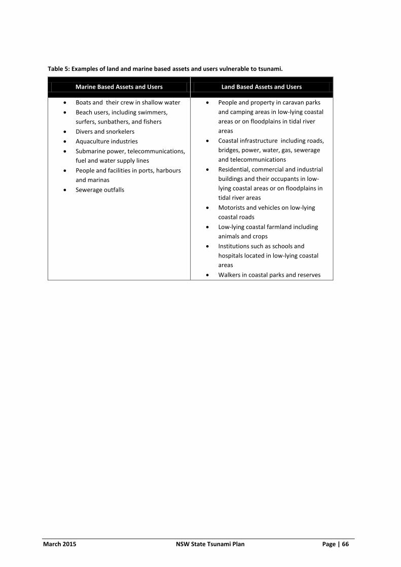
March 2015 NSW State Tsunami Plan Page | 66
Table 5: Examples of land and marine based assets and users vulnerable to tsunami.
Marine Based Assets and Users Land Based Assets and Users
Boats and their crew in shallow water
Beach users, including swimmers,
surfers, sunbathers, and fishers
Divers and snorkelers
Aquaculture industries
Submarine power, telecommunications,
fuel and water supply lines
People and facilities in ports, harbours
and marinas
Sewerage outfalls
People and property in caravan parks
and camping areas in low-lying coastal
areas or on floodplains in tidal river
areas
Coastal infrastructure including roads,
bridges, power, water, gas, sewerage
and telecommunications
Residential, commercial and industrial
buildings and their occupants in low-
lying coastal areas or on floodplains in
tidal river areas
Motorists and vehicles on low-lying
coastal roads
Low-lying coastal farmland including
animals and crops
Institutions such as schools and
hospitals located in low-lying coastal
areas
Walkers in coastal parks and reserves

March 2015 NSW State Tsunami Plan Page | 67
Table 6: Possible Vulnerable Population in NSW (2011 census) within 1km of coast and below the 10m contour height (AHD).
Total Population
Dwellings No Vehicle at Dwelling
Schools / Childcare Centres
School Age Children (Pre to
High School)
Public / Private
Hospitals
Aged Care / Nursing Homes
Age >= 85
Caravan Park / Camping Grounds
Northern Rivers 23649 9526 675 24 3565 2 6 570 33
Mid North Coast 29395 12436 1215 17 4225 0 0 814 60
Hunter 46818 19112 2165 25 6257 3 6 1541 48
Lord Howe Island 360 129 22 0 36 1 0 8 0
Metropolitan 104616 42796 8570 84 10434 1 4 2284 9
Illawarra 38588 15649 2132 26 5402 0 6 1119 48
South Coast 10767 4436 358 10 1505 0 1 489 47
NSW Total 254193 104084 15137 186 31424 7 23 6825 245
Note: Figures quoted are approximate. There may be areas impacted that are adjacent to tidal rivers or estuaries further than 1km from the coast.

March 2015 NSW State Tsunami Plan Page | 68
8.3 WARNING AND ARRIVAL TIMES
8.3.1 Tsunami warning and arrival times are dependent on both proximity and source as discussed in Part 8. Examples include:
Local Sources – Travel time from a local source could be within minutes.
Regional Sources - Travel time from regional sources to the NSW coast varies but is in the order of several hours.
Distant Sources - Travel time from distant sources to the NSW coast varies but is in the order of several hours to days.
8.3.2 Lord Howe Island will have shorter warning time than the NSW coast for tsunami generated closer to the island than the NSW coast (10).
8.3.3 The following table lists arrival times for five modelled sites in NSW.
Table 7: Summary List of Modelled Tsunami Scenario Arrival Times (21)
Average Reoccurrence Interval (ARI)
SOURCE TIDE
Tsunami Arrival Time (hours:mins)
Site
Lake Macquarie
Manly Botany Bay
Wollongong Port
Kembla
Merimbula
200 (possible*)
Kermadec HAT 04:37 04:36 04:36 04:41 04:46
200 New Hebrides
HAT 03:50 03:54 03:56 04:14 04:18
200 Puysegur HAT 02:40 02:38 02:34 02:31 02:27
200 South Chile
HAT 14:04 14:02 14:00 13:57 13:41
200 Tonga HAT 05:15 05:21 05:23 05:40 05:48
500 (unlikely) Kermadec HAT 04:35 04:33 04:34 04:39 04:44
500 New Hebrides
HAT 03:46 03:49 03:51 04:00 04:15
500 Puysegur HAT 02:31 02:31 02:31 02:27 02:20
500 Tonga HAT 05:09 05:10 05:10 05:17 05:32
1000 (unlikely)
Kermadec HAT 04:33 04:32 04:34 04:38 04:43
1000 New Hebrides
HAT 03:44 03:48 03:50 03:57 04:12
1000 Puysegur HAT 02:29 02:29 02:28 02:27 02:19
2000 (unlikely)
Kermadec HAT 04:32 04:31 04:33 04:37 04:42
2000 New Hebrides
HAT 03:43 03:46 03:48 03:56 04:11
2000 Puysegur HAT 02:29 02:27 02:27 02:26 02:18

March 2015 NSW State Tsunami Plan Page | 69
Average Reoccurrence Interval (ARI)
SOURCE TIDE
Tsunami Arrival Time (hours:mins)
Site
Lake Macquarie
Manly Botany Bay
Wollongong Port
Kembla
Merimbula
2000 Kermadec MSL 04:32 04:31 04:33 04:37 04:42
2000 New Hebrides
MSL 03:43 03:46 03:48 03:56 04:11
2000 Puysegur MSL 02:29 02:27 02:27 02:26 02:18
5000 (rare) New Hebrides
HAT 03:42 03:44 03:47 03:54 04:10
5000 Puysegur HAT 02:28 02:27 02:26 02:26 02:17
5000 New Hebrides
MSL 03:42 03:44 03:47 03:54 04:10
5000 Puysegur MSL 02:28 02:27 02:26 02:26 02:17
10000
(very rare)
New Hebrides
HAT 03:40 03:43 03:46 03:52 04:09
10000 Puysegur HAT 02:28 02:26 02:26 02:25 02:17
* likelihood levels are from the National Emergency Risk Assessment Guidelines (22)
HAT refers to Highest Astronomical Tide, MSL refers to Mean Sea Level
Map 2 shows the location of regional tsunami sources.

<IMAGE REMOVED IN RTF VERSION – NSW State Emergency Service Logo>
TSUNAMI WARNING
ARRANGEMENT SUMMARY,
TSUNAMI SOURCE AND DART
LOCATIONS
Volume 3 of the NSW State Tsunami Plan
March 2015

March 2015 NSW State Tsunami Plan Page | 71
8.4 LOCATION OF DEEP OCEAN TSUNAMI BUOYS USED TO DETECT AND EVALUATE TSUNAMI
Map supplied courtesy of the National Oceanographic and Atmospheric Administration,
United States of America.
<IMAGE REMOVED IN RTF VERSION – Map 1>
Map 1: Location of deep ocean tsunami buoys used to detect and evaluate tsunami

March 2015 NSW State Tsunami Plan Page | 72
8.5 LOCATION OF PLATE BOUNDARIES AND SUBDUCTION ZONES
Map supplied courtesy of Source: Geoscience Australia.
<IMAGE REMOVED IN RTF VERSION – Map 2>
Map 2: Location of plate boundaries and subduction zones

March 2015 NSW State Tsunami Plan Page | 73
8.6 TSUNAMI WARNING TRANSMISSION
Joint Australian Tsunami Warning Centre (JATWC) Tsunami Warning Product
<IMAGE REMOVED IN RTF VERSION – Figure 4>
Figure 4: Joint Australian Tsunami Warning Centre (JATWC) Tsunami Warning Product

March 2015 NSW State Tsunami Plan Page | 74
8.7 GENERAL TSUNAMI WARNING TRANSMISSION TO NSW
<IMAGE REMOVED IN RTF VERSION – Figure 5>
Figure 5: General Tsunami Warning Transmission to NSW

March 2015 NSW State Tsunami Plan Page | 75
8.8 DISSEMINATION THE BUREAU NSW TSUNAMI WARNINGS TO MARINE BASED RISK GROUPS
<IMAGE REMOVED IN RTF VERSION – Figure 6>
Figure 6: Dissemination of the Bureau NSW Tsunami Warnings to marine based groups
March 2015 NSW State Tsunami Plan Page | 76
8.9 DISSEMINATION OF THE BUREAU NSW TSUNAMI WARNINGS TO LAND BASED RISK GROUPS
<IMAGE REMOVED IN RTF VERSION – NSW State Emergency Service Logo>
<IMAGE REMOVED IN RTF VERSION – Figure 7>
Figure 7: Dissemination of the Bureau NSW Tsunami Warnings to land based risk group

March 2015 NSW State Tsunami Plan Page | 77
8.10 SUMMARY OF WARNING ARRANGEMENTS AND SUGGESTED METHODS OF WARNING
Table 8: Summary of Warning Arrangements and Suggested Methods of Warning
Element requiring warning (Risk Group)
Agencies primarily responsible for assisting the NSW SES with
warning dissemination Possible warning methods
Aquaculture (land/marine) Agriculture and Animal Services Functional Area
NSW Police Force
Fire and Rescue NSW
NSW Rural Fire Service
Marine Rescue NSW
Telephone tree
Radio and television broadcasts
Doorknocking
Beach users (marine) Surf Life Saving NSW
NSW Police Force
Fire and Rescue NSW
NSW Rural Fire Service
Marine Rescue NSW
Fixed and mobile public address systems
Low flying aircraft equipped with public address systems
Radio broadcasts
Sirens
Boats and their crew (marine) NSW Police Force Marine Area Command
Roads and Maritime Services
Marine Rescue NSW
Australian Marine Safety Authority
Port Authority of NSW
Marine Parks Authority NSW (Department of Primary Industries)
Lord Howe Island Port Operations
Agriculture and Animal Services Functional Area
Private Boat Companies
Marine radio calling and distress frequencies
Low flying aircraft equipped with public address systems
Radio broadcasts
Marine satellite phone
Camping areas (land) Office of Environment and Heritage (National Parks and Wildlife Service)
Agriculture and Animal Services Functional Area
NSW Police Force
Fire and Rescue NSW
NSW Rural Fire Service
NSW VRA
Radio broadcasts
Doorknocking of known camp sites
Mobile public address systems
Low-flying aircraft equipped with public address systems.
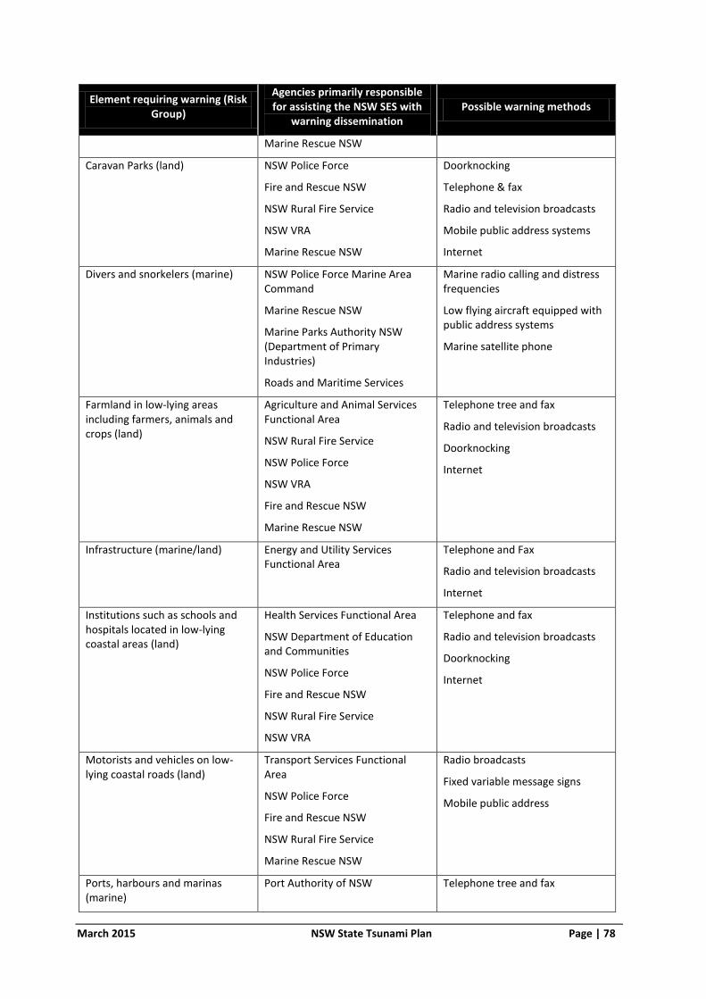
March 2015 NSW State Tsunami Plan Page | 78
Element requiring warning (Risk Group)
Agencies primarily responsible for assisting the NSW SES with
warning dissemination Possible warning methods
Marine Rescue NSW
Caravan Parks (land) NSW Police Force
Fire and Rescue NSW
NSW Rural Fire Service
NSW VRA
Marine Rescue NSW
Doorknocking
Telephone & fax
Radio and television broadcasts
Mobile public address systems
Internet
Divers and snorkelers (marine) NSW Police Force Marine Area Command
Marine Rescue NSW
Marine Parks Authority NSW (Department of Primary Industries)
Roads and Maritime Services
Marine radio calling and distress frequencies
Low flying aircraft equipped with public address systems
Marine satellite phone
Farmland in low-lying areas including farmers, animals and crops (land)
Agriculture and Animal Services Functional Area
NSW Rural Fire Service
NSW Police Force
NSW VRA
Fire and Rescue NSW
Marine Rescue NSW
Telephone tree and fax
Radio and television broadcasts
Doorknocking
Internet
Infrastructure (marine/land) Energy and Utility Services Functional Area
Telephone and Fax
Radio and television broadcasts
Internet
Institutions such as schools and hospitals located in low-lying coastal areas (land)
Health Services Functional Area
NSW Department of Education and Communities
NSW Police Force
Fire and Rescue NSW
NSW Rural Fire Service
NSW VRA
Telephone and fax
Radio and television broadcasts
Doorknocking
Internet
Motorists and vehicles on low-lying coastal roads (land)
Transport Services Functional Area
NSW Police Force
Fire and Rescue NSW
NSW Rural Fire Service
Marine Rescue NSW
Radio broadcasts
Fixed variable message signs
Mobile public address
Ports, harbours and marinas (marine)
Port Authority of NSW Telephone tree and fax

March 2015 NSW State Tsunami Plan Page | 79
Element requiring warning (Risk Group)
Agencies primarily responsible for assisting the NSW SES with
warning dissemination Possible warning methods
Roads and Maritime Services
NSW Police Force (NSW Police Force Marine Area Command)
Marine Rescue NSW
Fire and Rescue NSW
NSW Rural Fire Service
Radio and television broadcasts
Doorknocking
Internet
Two-way radio
Mobile public address systems
Residential, commercial and industrial buildings and their occupants in low-lying coastal areas or floodplains in tidal river areas (land)
NSW Police Force
Fire and Rescue NSW
NSW Rural Fire Service
NSW VRA
Marine Rescue NSW
Radio and television broadcasts
Mobile and fixed public address systems
Doorknocking
Internet
Sirens
Variable message signs
Low-flying aircraft equipped with public address systems
Walkers in coastal parks and reserves (land/marine)
Office of Environment and Heritage (National Parks and Wildlife Service)
Agriculture and Animal Services Functional Area
NSW Police Force
Fire and Rescue NSW
NSW Rural Fire Service
NSW VRA
Marine Rescue NSW
Mobile Public Address
Low-flying aircraft equipped with public address systems

March 2015 NSW State Tsunami Plan Page | 80
LIST OF REFERENCES
1. Ministry for Police and Emergency Services. New South Wales State Emergency Management
Plan (EMPLAN). 2012.
2. Emergency Management Australia. Australian Emergency Management Glossary. s.l. : Attorney-
General's Department, 1998.
3. Essential Services Act 1988 (NSW).
4. A Nearshore Tsunami Hazard Assessment for Australia. Geoscience Australia Professional Opinion.
No.2009/06. Fountain, L, Van Putten, K., Griffin, J., Hingee, M., Wilson, R., Burbidge. 2009.
5. Bureau of Meteorology. Bureau of Meteorology Glossary of Terms. Australian Government
Bureau of Meteorology. [Online] Bureau of Meteorology. [Cited: 07 14, 2014.]
6. NSW Government. State Emergency Rescue Management Act (SERM Act). 1989.
7. Bureau of Meteorology. Tsunami Facts and Information. Australian Government Bureau of
Meteorology. [Online] Bureau of Meteorology. [Cited: 07 14, 2014.]
8. NSW Ministry for Police and Emergency Services. NSW State Emergency Management Plan
(EMPLAN). 2012.
9. Bureau of Meteorology. About Tsunami Warnings. [Online] [Cited: 09 29, 2014.]
http://www.bom.gov.au/tsunami/about/tsunami_warnings.shtml.
10. NSW State Emergency Service. Tsunami Emergency Sub-Plan. 2008.
11. Attorney-General's Department. Tsunami Emergency Planning in Australia. s.l. : Attorney-
General's Department, 2010.
12. Bureau of Meteorology. Tsunami Frequently Asked Questions. Bureau of Meteorology. [Online]
2014. [Cited: 07 23, 2014.]
13. USGS. Earthquakes. USGS. [Online] [Cited: August 12, 2013.]
http://earthquake.usgs.gov/earthquake/eqinthenews/2011/usc0001xgp.
14. Progress Towards an Understanding of Tsunami Risk in NSW. Andrews, F., Beadle, C., Davies, B.,
Frazer, A., Garber, S., Greenslade, D., Hanslow, D., Horspool, N., Kuster, N., Opper, S., and Treloar,
D. 2013.
15. Morphology of Australia’s Eastern Continental Slope and Related Tsunami Hazard. Samantha
Clarke, Thomas Hubble, David Airey, Phyllis Yu, Ron Boyd,. s.l. : Springer International Publishing
Switzerland 2014, 2014.
16. Bureau of Meteorology. Records of Tsunamis affecting Australia. [Online] [Cited: 07 18, 2014.]
17. NSW State Emergency Service. Measurements and Impacts of the Chilean Tsunami of May 1960
in NSW Australia. 2009.

March 2015 NSW State Tsunami Plan Page | 81
18. Waverley Library. Waverley Library Black Sunday. Waverely Library. [Online] [Cited: 07 18,
2014.]
19. Burbidge, D., Mleczko,R., Thomas, C., Cumminis,P., Nielsen, O., Dhu, T. A Probabilistic Tsunami
Hazard Assessment for Australia. Geoscience Australia Professional Opinion No.2008/04. 2008.
20. Risk Frontiers, Macquarie University. Development of Information for a Tsunami Risk
Assessment of the NSW Coast. 2008.
21. Cardno Pty Ltd. NSW Tsunami Inundation Modelling and Risk Assessment. 2013.
22. National Emergency Management Committee. National Emergency Risk Management
Guidelines. 2010.
23. UK Government Cabinet Office. Lexicon of UK civil protection terminology - version 2.1.1. 2013.
24. Australasian Fire and Emergency Service Authorities Council. The Australian Inter-Service
Incident Management System (AIIMS): A management system for any emergency: Edition 4. 2013.
25. NSW Government. Welfare Services Functional Area Supporting Plan: A supporting Plan to the
NSW Emergency Management Plan. June 2014.