17. tsunami sub plan - rockhamptonregion.qld.gov.au · sop standard operating procedure ....
TRANSCRIPT
Annexure 4 Sub Plans 17. Tsunami Sub Plan

Abbreviations and Glossary ATWS Australian Tsunami Warning System
BoM Bureau of Meteorology
CALD Culturally & Linguistically Diverse
Council Rockhampton Regional Council
DDC District Disaster Coordinator
DDCC District Disaster Coordination Centre
DDMG District Disaster Management Group
DETE Department of Education, Training and Employment
DHPW Department of Housing & Public Works
DTMR Department of Transport and Main Roads
EA Emergency Alert
QFES EM Queensland Fire and Emergency Services - Emergency Management
EPA Environmental Protection Agency
FRW Fitzroy River Water
GA Geoscience Australia
JATWC Joint Australian Tsunami Warning Centre
LDC Local Disaster Coordinator
LDCC Local Disaster Coordination Centre
LDMG Rockhampton Regional Council Local Disaster Management Group
LDMP Local Disaster Management Plan
PTWC Pacific Tsunami Warning Centre
QAS Queensland Ambulance Service
QFES Queensland Fire and Emergency Service
QPS Queensland Police Service
Region the area under the management of Rockhampton Regional Council
RRC Rockhampton Regional Council
RSPCA Royal Society for the Prevention of Cruelty to Animals
SES State Emergency Service
SEWS Standard Emergency Warning System
SOP Standard Operating Procedure
Rockhampton Regional Council Local Disaster Management Plan – 17. Tsunami Sub Plan Page 2

TABLE OF CONTENTS
1 INTRODUCTION ................................................................................................................... 5
1.1 PURPOSE ............................................................................................................................. 5
1.2 OBJECTIVES ........................................................................................................................ 5
1.3 SCOPE .................................................................................................................................. 5
1.4 PLANNING ............................................................................................................................ 5
1.5 MEDIA AND PUBLIC INFORMATION ARRANGEMENTS ..................................................... 5
1.6 FINANCIAL PROCEDURES .................................................................................................. 6
1.7 PLAN TESTING REQUIREMENTS........................................................................................ 6
1.8 CONTACT LIST ..................................................................................................................... 6
2 AUSTRALIA’S VULNERABILITY TO TSUNAMI ................................................................... 7
2.1 TSUNAMI INFORMATION ..................................................................................................... 7
2.1.1 Tsunami Physics ...................................................................................................... 8
2.1.2 What happens to a Tsunami as it approaches land .................................................. 9
2.2 MEASURING AND OBSERVATION ...................................................................................... 9
2.2.1 Tide Gauges ............................................................................................................ 9
2.2.2 Satellites .................................................................................................................. 9
2.2.3 The DART System ................................................................................................. 10
2.3 TSUNAMIS THROUGH HISTORY ....................................................................................... 10
2.4 FURTHER INFORMATION .................................................................................................. 12
3 EVENT RESPONSE & COORDINATION ............................................................................ 12
3.1 ACTIVATION OF LOCAL DISASTER MANAGEMENT GROUP (LDMG) AND LOCAL
DISASTER COORDINATION CENTRE (LDCC) .................................................................. 13
3.2 PUBLIC INFORMATION ...................................................................................................... 13
3.3 WARNINGS ......................................................................................................................... 13
3.3.1 Australian Tsunami Warning System ...................................................................... 14
3.3.2 Tsunami Warning Messages Summary .................................................................. 16
3.4 OTHER WARNING SYSTEMS ............................................................................................ 17
3.4.1 Standard Emergency Warning System (SEWS) ..................................................... 17
3.4.2 Emergency Alert..................................................................................................... 17
3.5 LOCAL WARNINGS ............................................................................................................ 18
3.6 EVACUATION ..................................................................................................................... 19
3.7 REMOTE AND ISOLATED COMMUNITIES ........................................................................ 19
3.8 CALD GROUPS AND SPECIAL NEEDS GROUPS ............................................................. 19
4 ROLES AND RESPONSIBILITIES ...................................................................................... 20
4.1 CONCEPT OF OPERATIONS ............................................................................................. 21
4.1.1 Pre Impact .............................................................................................................. 21
4.1.2 Impact .................................................................................................................... 22
4.1.3 Immediate Post Impact ........................................................................................... 23
Rockhampton Regional Council Local Disaster Management Plan – 17. Tsunami Sub Plan Page 3

5 POST IMPACT ASSESSMENT ........................................................................................... 23
5.1 FUNCTIONAL ARRANGEMENTS ....................................................................................... 25
5.1.1 Lead Agency .......................................................................................................... 25
5.1.2 Support Agency...................................................................................................... 27
6 RECOVERY ......................................................................................................................... 27
6.1 COMMUNITY RECOVERY .................................................................................................. 27
6.2 INFRASTRUCTURE RECOVERY ....................................................................................... 27
6.2.1 Water Services ....................................................................................................... 27
6.2.2 Sewerage Services ................................................................................................ 27
6.2.3 Roads and Bridges ................................................................................................. 28
6.2.4 Buildings ................................................................................................................ 28
6.3 ECONOMIC RECOVERY .................................................................................................... 28
6.4 ENVIRONMENTAL RECOVERY ......................................................................................... 28
7 MISCELLANEOUS ISSUES / ARRANGEMENTS ............................................................... 28
7.1 PURPOSE ........................................................................................................................... 28
7.2 OTHER SUB PLANS ........................................................................................................... 28
7.3 POPULATION AND DEMOGRAPHICS ............................................................................... 28
7.4 PUBLIC EDUCATION .......................................................................................................... 29
7.5 TRANSPORTATION ............................................................................................................ 29
7.6 REVIEW AND ASSESSMENT OF PLANS........................................................................... 29
7.7 PROTRACTED OPERATIONS ............................................................................................ 29
7.8 CONCLUSION OF OPERATIONS (STAND DOWN) AND DEBRIEF ................................... 29
Rockhampton Regional Council Local Disaster Management Plan – 17. Tsunami Sub Plan Page 4

1 INTRODUCTION
1.1 PURPOSE
The purpose of the Rockhampton Regional Council Tsunami Sub Plan is to detail the agreed emergency management arrangements, at the local level, in preparing for and responding to the effects of tsunamis in the Rockhampton Regional Council area.
1.2 OBJECTIVES
The objectives of the Rockhampton Regional Tsunami Sub Plan are to: 1. Identify/determine the effects of tsunamis on the community; 2. Define emergency services and supporting agency responsibilities; 3. Prescribe and implement agency activation arrangements; 4. Provide effective liaison between all emergency services and supporting agencies; 5. Provide arrangements for efficient coordination of local resources and any external
support resources; 6. Prescribe public warning systems; 7. Establish and implement public information, education systems; and 8. Prescribe arrangements for testing, evaluation and maintenance of this plan.
1.3 SCOPE
The Tsunami Sub Plan applies to the effects of a tsunami occurring within the Rockhampton Regional Council area. 1.4 PLANNING
The Cyclone and Storm Sub Committee is the organisation responsible for planning and coordinating response to the effects of Tsunami in the region. The Cyclone and Storm Sub Committee will maintain currency of this plan by:
▪ Ensuring that all agencies referred to in the Plan are aware of their roles and responsibilities;
▪ Conducting exercises to test arrangements; ▪ Regularly reviewing the contents of this plan:
▪ After any tsunami operation; ▪ When there are changes which alter agreed plan arrangements; ▪ After conduct of any exercises to test this plan, or ▪ A minimum of once per year.
1.5 MEDIA AND PUBLIC INFORMATION ARRANGEMENTS
Emergencies and disasters such as Tsunamis are likely to draw significant media interest and a very significant requirement for public information. The response to these needs is to be drafted by the Media Liaison Officer and approved by the LDC and/or Chair of the LDMG in accordance with the Communication Sub Plan.
Rockhampton Regional Council Local Disaster Management Plan – 17. Tsunami Sub Plan Page 5

1.6 FINANCIAL PROCEDURES
All costs incurred by Council as a result of a disaster event will be coordinated by the Local Disaster Coordinator (LDC). Upon activation of the LDMG, a disaster cost centre and project/job numbers will be created and activated to capture costs for deployment of resources and response and recovery activities. Cost centre and project/job numbers will be provided by Council’s Finance Section. Council’s financial management policy and procedures will govern all financial delegations and authorisations to expend funds, recording of expenditure, etc. Lead and Support Agencies should also record all costs associated with a disaster response in accordance with their individual financial management policies and procedures. The Chairperson of the Cyclone and Storm Sub Committee is responsible for ensuring that all costs associated with the implementation of this plan in response to a Tsunami event are adequately recorded under the appropriate project/job numbers. 1.7 PLAN TESTING REQUIREMENTS
This Sub Plan together with supporting standard operating procedures (SOP’s) is to be tested annually. This could involve the conduct of relevant exercises or the implementation of the plan in “real time”. The Chair of the Cyclone and Storm Sub Committee is to brief the LDMG on the results of such tests. 1.8 CONTACT LIST
The contact list for members of the Cyclone and Storm Sub Committee is held by the Disaster Management Officer. The Chair of the Cyclone and Storm Sub Committee is responsible for ensuring the contact list is maintained and up to date.
Rockhampton Regional Council Local Disaster Management Plan – 17. Tsunami Sub Plan Page 6

2 AUSTRALIA’S VULNERABILITY TO TSUNAMI
Australia is bounded on the northwest, northeast and east by some 8,000 km of active tectonic plate boundary capable of generating tsunamis, which could reach our coastline within two to four hours. One-third of all earthquakes worldwide occur along these boundaries. The impact of a tsunami hitting vulnerable low-lying areas of the Australian coast could be significant. Tsunami are recorded in Australia about once every two years, and most are small and present little threat of land inundation to our coastal communities. However, the abnormal waves, tides and currents caused by even relatively small tsunami can be dangerous to swimmers and mariners.
2.1 TSUNAMI INFORMATION
A tsunami is a series of ocean waves with very long wavelengths (typically hundreds of kilometres) caused by large-scale disturbances of the ocean, such as:
▪ earthquakes; landslide; volcanic eruptions; explosions; or meteorites.
These disturbances can either be from below (e.g. underwater earthquakes with large vertical displacements, submarine landslides) or from above (e.g. meteorite impacts). Tsunami is a Japanese word with the English translation: “harbour wave”. In the past, tsunamis have been referred to as “tidal waves” or “seismic sea waves”. The term “tidal wave” is misleading; even though a tsunami’s impact upon a coastline is dependent upon the tidal level at the time a tsunami strikes, tsunamis are unrelated to the tides. (Tides result from the gravitational influences of the moon, sun and planets). The term “seismic sea wave” is also misleading. “Seismic” implies an earthquake related generation mechanism, but a tsunami can also be caused by a non seismic event such as a landslide or meteorite impact. Tsunamis are also often confused with storm surges, even though they are quite different phenomena. A storm surge is a rapid rise in coastal sea-level caused by a significant meteorological event – these are often associated with tropical cyclones.
Rockhampton Regional Council Local Disaster Management Plan – 17. Tsunami Sub Plan Page 7

2.1.1 Tsunami Physics Tsunamis can have wavelengths ranging from 10 to 500 km and wave periods of up to an hour. As a result of their long wavelengths, tsunamis act as shallow-water waves. A wave becomes a shallow-water wave when the wavelength is very large compared to the water depth. Shallow-water waves move at a speed, c, that is dependent upon the water depth and is given by the formula c = √ gH, where g is the acceleration due to gravity (=9.82 m/s) and H is the depth of water. In the deep ocean, the typical water depth is around 4000 m, so a tsunami will therefore travel at around 200 m/s, or more than 700 km/hr. For tsunamis that are generated by underwater earthquakes, the amplitude (i.e. wave height) of the tsunami is determined by the amount by which the sea floor is displaced. Similarly, the wavelength and period of the tsunami are determined by the size and shape of the underwater disturbance. As well as travelling at high speeds, tsunamis can also travel large distances with limited energy losses. As the tsunami propagates across the ocean, the wave crests can undergo refraction (bending), which is caused by segments of the wave moving at different speeds as the water depth along the wave crest varies. Rockhampton Regional Council Local Disaster Management Plan – 17. Tsunami Sub Plan Page 8

2.1.2 What happens to a Tsunami as it approaches land As a tsunami leaves the deep water of the open ocean and travels into the shallower water near the coast, it transforms. A tsunami travels at a speed that is related to the water depth – hence, as the water depth decreases, the tsunami slows. The tsunami’s energy flux, which is dependent on both its wave speed and wave height, remains nearly constant. Consequently, as the tsunami’s speed diminishes, its height grows. This is called shoaling. Because of this shoaling effect, a tsunami that is unnoticeable at sea may grow to be several metres or more in height near the coast (e.g. a tsunami with a height of 1 metre in the open ocean where the water depth is 4000m would have a wave height of 2 to 5 m in water of depth 10m). Just like other water waves, tsunamis begin to lose energy as they rush onshore – part of the wave energy is reflected offshore, while the shoreward-propagating wave energy is dissipated through bottom friction and turbulence. Despite these losses, tsunamis still reach the coast with tremendous amounts of energy. Depending on whether the first part of the tsunami to reach the shore is a crest or trough, it may appear as a rapidly rising or falling tide. Local bathymetry may also cause the tsunami to appear as a series of breaking waves. Tsunamis have great erosion potential, stripping beaches of sand that may have taken years to accumulate and undermining trees and other coastal vegetation. Capable of inundating, or flooding, hundreds of metres inland past the typical high-water level, the fast moving water associated with the inundating tsunami can crush homes and other coastal structures. Tsunamis may reach a maximum vertical height onshore above sea level, often called a run-up height, of tens of metres.
2.2 MEASURING AND OBSERVATION
In the deep ocean, a tsunami has a small amplitude (less than 1 metre) but very long wavelength (hundreds of kilometres). This means that the slope or steepness of the wave is very small, so it is practically undetectable to the human eye. However, there are ocean observing instruments that are able to detect tsunamis.
2.2.1 Tide Gauges Tide gauges measure the height of the sea-surface and are primarily used for measuring tide levels. Most of the tide gauges operated by the Bureau of Meteorology’s National Tidal Centre are SEAFRAME stations (Sea Level Fine Resolution Acoustic Measuring Equipment). These consist of an acoustic sensor connected to a vertical tube open at the lower end which is in the water. The acoustic sensor emits a sound pulse which travels from the top of the tube down to the water surface, and is then reflected back up the tube. The distance to the water level can then be calculated using the travel time of the pulse. This system filters out small-scale effects like wind-waves and has the capacity to measure sea-level changes within 1mm accuracy.
2.2.2 Satellites Satellite altimeters measure the height of the ocean surface directly by the use of electro-magnetic pulses. These are sent down to the ocean surface from the satellite and the height of the ocean surface can be determined by knowing the speed of the pulse, the location of the satellite and measuring the time that the pulse takes to return to the satellite. One problem with this kind of satellite data is that it can be very sparse - some satellites only pass over a particular location about once a month, so you would be lucky to spot a tsunami since they travel so quickly. However, during the Indian Ocean tsunami of December 26th, 2004, the Jason satellite altimeter happened to be in the right place at the right time.
Rockhampton Regional Council Local Disaster Management Plan – 17. Tsunami Sub Plan Page 9

2.2.3 The DART System In 1995 the National Oceanic and Atmospheric Administration (NOAA) began developing the Deep-ocean Assessment and Reporting of Tsunamis (DART) system. An array of stations is currently deployed in the Pacific Ocean. These stations give detailed information about tsunamis while they are still far off shore. Each station consists of a sea-bed bottom pressure recorder which detects the passage of a tsunami. (The pressure of the water column is related to the height of the sea-surface). The data is then transmitted to a surface buoy via sonar. The surface buoy then radios the information to the Pacific Tsunami Warning Centre (PTWC) via satellite. The bottom pressure recorder lasts for two years while the surface buoy is replaced every year. The system has considerably improved the forecasting and warning of tsunamis in the Pacific. 2.3 TSUNAMIS THROUGH HISTORY
Destructive tsunamis have occurred in all of the world's oceans and seas. The following table lists many of these, along with the cause and the estimated number of deaths.
Major Historical Tsunamis
Date Place Description Estimated Deaths
July 21, AD 365 Alexandria Generated by earthquake 50,000 + June 7, 1692 Port Royal, Jamaica Generated by earthquake Thousands 1707 Japan Generated by earthquake 30,000
November 1, 1755 Lisbon, Portugal Waves 6-15 m high generated by earthquake 10,000-60,000
August 8, 1868 Arica, Chile 15 m wave generated by earthquake Thousands August 26-27, 1883 Krakatoa, Indonesia Generated by eruption of volcano 36,000
June 15, 1896 Honshu, Japan 30 m wave generated by earthquake; destroyed 280 km coastline 27,122
December 28, 1908 Messina in Sicily and Italian coastal cities Earthquake and 8 m wave 120,000
September 1, 1923 Sagami Bay, Kanto Plain, Atami and Nebukawa, Japan
Earthquake, fire, mudslide and 11 m wave 145,000
November 18, 1929 Grand Banks, Newfoundland
Triggered by a sub-marine landslide and earthquake 29
March 3, 1933 Sanriku, Japan Generated by earthquake 2,990
April 1, 1946 Hilo, Hawaii and Aleutian Islands, Alaska
Generated by earthquake on Unimak Island, Alaska, creating waves up to 35 m high
165
November 4, 1952 Kamchatka Peninsula, Russia Triggered by earthquake
Property damage, no human lives were lost
March 9, 1957 Aleutian Islands, Alaska. Also Hawaii
Triggered by earthquake south of the Andreanof Islands
Thanks to a timely alarm from the International Pacific Tsunami Warning Centre at Honolulu, no human lives were lost
July 9, 1958 Lituya Bay, Alaska Earthquake caused huge slab of ice and rock to fall off nearby glacier into bay; giant splash formed tsunami
3
May 1960 Chile Generated by a series of earthquakes 2,300
May 1960 Hilo, Hawaii
Generated by a series of earthquakes (same as Chile on the same date)
61
Rockhampton Regional Council Local Disaster Management Plan – 17. Tsunami Sub Plan Page 10

Date Place Description Estimated Deaths
March 28, 1964 Prince William Sound, Alaska
An earthquake and subsequent landslides generated a series of tsunamis, the highest reaching close to 30 m
130
November 29, 1975 Island of Hawaii Earthquake off the coast of the Island of Hawaii generated waves between 2 m and 15 m high
2
August 17, 1976 Mindanao, Philippines Generated by earthquake 8,000
July 18, 1979 Lomblem Island, Indonesia
2 m wave generated by volcano collapse 539
October 16, 1979 Nice, France Undersea landslides generated 2 tsunamis one week apart 23
September 1, 1992 Nicaragua Earthquake caused series of waves 11 m high 170
December 12, 1992 Flores Island & Babi Island
Series of tsunamis, generated by earthquake. Waves ranging from 5 m to 25 m high, depending where they hit.
1690 (Flores) 263 (Babi)
July 12, 1993 Island of Okushiri, Japan
Underwater earthquake generated waves 5 to 30 m high 200 +
June 3, 1994 Eastern Java, Indonesia
Earthquakes caused series of waves more than 60 m high 223
November 11, 1994 Mindoro Island Generated by earthquake. Waves 7 m high 70
October 9, 1995 Jalisco, Mexico Generated by earthquake. Waves 11 m high 1
January 1, 1996 Minahassa Peninsula, area of Sulawesi
Generated by earthquake. Waves 4 m high 24
February 17, 1996 Biak, Irian Java Generated by earthquake. Waves ranging from 5 to 10 m high 161
February 21, 1996 North Coast of Peru Generated by earthquake. Waves 5 m high 12
July 17, 1998 Papua - New Guinea Generated by earthquake. Waves ranging from 7 m to 15 m high 3,000
September 15th, 1999
Fatu Hiva, Marquesas Islands
Generated by landslide. Two waves 5 m high
Property damage, no human lives were lost
December 26th, 2004 Indian Ocean- Indonesia, Sri Lanka, India and Thailand
Generated by earthquake. Waves up to 30m.
230,000 killed 1.7million displaced
March 11th, 2011 Great Tōhoku Earthquake-, Japan
Generated by earthquake. Waves up to 33m, inland to 10km
15,000 dead 9,000 missing
Rockhampton Regional Council Local Disaster Management Plan – 17. Tsunami Sub Plan Page 11

2.4 FURTHER INFORMATION
Further information can be found at General information
International Tsunami Information Centre Welcome to tsunami! Tsunami database (U.S. National Geophysical Data Centre)
Tsunami warning centres and hazard mitigation
International Coordination Group for the Tsunami Warning System in the Pacific Pacific Tsunami Warning Centre West Coast and Alaska Tsunami Warning Centre U.S. National Tsunami Hazard Mitigation Program
Earthquake information
Geoscience Australia U.S. National Earthquake Information Centre European-Mediterranean Seismological Centre
The Indian Ocean tsunami of Dec. 26th, 2004
Scientific Background (from Columbia University) Tsunami research
Tsunami Research Centre (University of Southern California) Tsunami Research Program (Pacific Marine Environmental Laboratory)
3 EVENT RESPONSE & COORDINATION
A basic requirement of Disaster Management response is a well equipped coordination centre capable of being made operational at short notice and having the capacity to accommodate all control personnel. The coordination of activities in response to an event will be undertaken within the nominated Local Disaster Coordination Centre (LDCC) located at:
The Reception Room (including the IT Training Room) Ground Floor Rockhampton Regional Council City Hall Bolsover Street Rockhampton
Should this facility become unusable for any reason, an alternative disaster coordination centre will be established at:
Dooley St Depot Administration Building 13 Dooley Street Park Avenue
Fitzroy Room- Rockhampton Library Bolsover Street Rockhampton
or as otherwise determined by the Chairperson of the Local Disaster Management Group (LDMG).
The operation of the LDCC will be as per the Local Disaster Coordination Centre Sub Plan.
The telephone numbers for public contact with the LDCC will be advertised upon activation of the centre.
Rockhampton Regional Council Local Disaster Management Plan – 17. Tsunami Sub Plan Page 12

LDCC may be permanent or temporary facilities, provided within each Local Government area to support the LDMG during disasters. Each LDCC is responsible to provide prompt and relevant information to the District Disaster Coordination Centre (DDCC) concerning any disaster event or potential disaster event occurring within their area. These Centres are also responsible for the coordination of all local resources as well as those allocated to it for disaster management purposes. In particular a LDCC is responsible for:
collection, collation and dissemination of information to the DDCC, relevant local agencies and officers, and the public;
implementation of operational decisions of the LDMG; and Coordination of Local Government and community resources in support of agencies
involved in response and recovery operations including those allocated from the Commonwealth, State and Disaster District, in support of the disaster affected community.
All agencies involved in the response to an event have a responsibility to collect, analyse, and disseminate relevant information received regarding the event. 3.1 ACTIVATION OF LOCAL DISASTER MANAGEMENT GROUP (LDMG) AND
LOCAL DISASTER COORDINATION CENTRE (LDCC) The following activation stages apply to the activation of the LDMG. Chairpersons of Sub Committees also have the discretion to activate sub committees as deemed necessary. However, the decision to activate a sub committee should be done, where possible, after consultation with the LDC and/or Chairperson of the LDMG. Stages of Activation as detailed in the LDMP section 5.3 and relevant sub plans. 3.2 PUBLIC INFORMATION At a local level, the release of information to the community regarding the emergency, and associated threats, will be the responsibility of the Chairperson of the LDMG or their delegate. Situations will arise that will require the release of information relevant to Disaster Management. The scale of the event, public and media interest and potential community impact will determine the level and frequency of information provision. Distribution of information to the public should occur on a regular basis whenever it is recognised that a potential threat exists or may exist, which may impact the local community. Information should be distributed upon activation of the LDMG, LDMP or LDCC. Methods of information distribution may vary and might include but are not limited to:
agency websites; radio and television; phone messages; emails.
TV and/or media interviews undertaken by the Chairperson of the LDMG should wherever possible, be undertaken in conjunction with the District Disaster Coordinator and representatives of other relevant response agencies. The release of information will be undertaken in accordance with the Communication Sub Plan and associated SOP’s. 3.3 WARNINGS As a result of the Australian Tsunami Warning System (ATWS) Project, jointly undertaken by the Bureau of Meteorology (BoM), Geoscience Australia (GA) and Emergency Management Australia and funded by the Australian Government, Australia now has a comprehensive, independent tsunami warning service to advise the media, public and emergency authorities of any tsunami threat to Australia and its offshore territories.
Rockhampton Regional Council Local Disaster Management Plan – 17. Tsunami Sub Plan Page 13
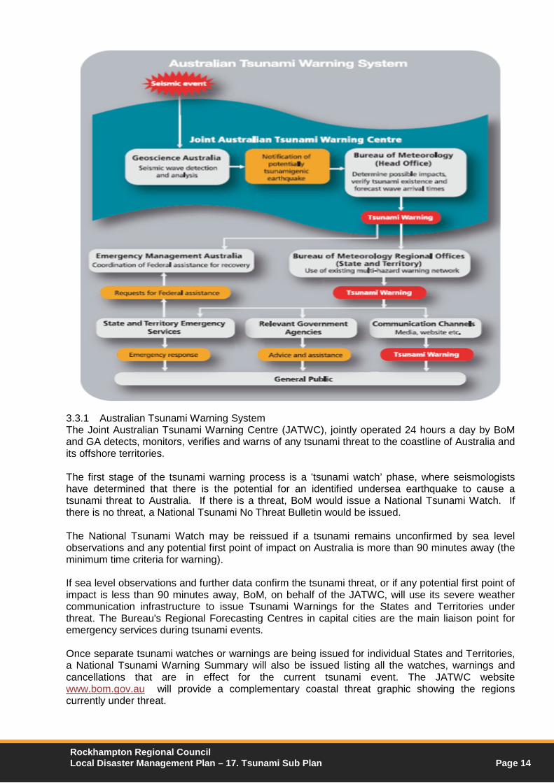
3.3.1 Australian Tsunami Warning System The Joint Australian Tsunami Warning Centre (JATWC), jointly operated 24 hours a day by BoM and GA detects, monitors, verifies and warns of any tsunami threat to the coastline of Australia and its offshore territories. The first stage of the tsunami warning process is a 'tsunami watch’ phase, where seismologists have determined that there is the potential for an identified undersea earthquake to cause a tsunami threat to Australia. If there is a threat, BoM would issue a National Tsunami Watch. If there is no threat, a National Tsunami No Threat Bulletin would be issued. The National Tsunami Watch may be reissued if a tsunami remains unconfirmed by sea level observations and any potential first point of impact on Australia is more than 90 minutes away (the minimum time criteria for warning). If sea level observations and further data confirm the tsunami threat, or if any potential first point of impact is less than 90 minutes away, BoM, on behalf of the JATWC, will use its severe weather communication infrastructure to issue Tsunami Warnings for the States and Territories under threat. The Bureau's Regional Forecasting Centres in capital cities are the main liaison point for emergency services during tsunami events. Once separate tsunami watches or warnings are being issued for individual States and Territories, a National Tsunami Warning Summary will also be issued listing all the watches, warnings and cancellations that are in effect for the current tsunami event. The JATWC website www.bom.gov.au will provide a complementary coastal threat graphic showing the regions currently under threat.
Rockhampton Regional Council Local Disaster Management Plan – 17. Tsunami Sub Plan Page 14

When the main threat has passed or if a tsunami did not eventuate, BoM will issue a Tsunami Watch Cancellation or Tsunami Warning Cancellation. The relevant State or Territory emergency authority will inform the public when it is safe to return to the affected area. A National Tsunami Event Summary is then issued after the event. Tsunami Bulletins, Watches, Warnings, Cancellations and Event Summaries are part of a suite of warnings for severe weather events and hazards issued by BoM. The media are the key communication dissemination mechanism that allows BoM to inform the public in the case of a tsunami event. Tsunami bulletin and warning distribution lists are maintained at each of the BoM’s State and Territory Regional Forecasting Centres. These distribution lists are used for both National JATWC Bulletins and Regional Warnings. In addition to the media, key agencies such as the State and Territory emergency services, local councils, port authorities, police etc. are included on these dissemination lists. The bulletin and warning messages are also automatically uploaded to the BoM’s website. The following table illustrates the Tsunami Warning Schedule:
Rockhampton Regional Council Local Disaster Management Plan – 17. Tsunami Sub Plan Page 15

3.3.2 Tsunami Warning Messages Summary
Messages – Types and
Purpose Categories of Threat Levels within
Tsunami Warnings
National No Threat Bulletin: To advise people that the earthquake has been assessed and that no tsunami threat exists
In order to assist the community, tsunami threat levels in Regional Tsunami warnings are categorised into three levels with required community responses; these have been determined in consultation with emergency management authorities.
These Threat Levels will be specified for the same coastal areas that are used for routine BoM Coastal Waters Forecasts, already known to marine users.
1. No threat - An undersea earthquake has been detected, however it has not generated a tsunami, or the tsunami poses no threat to Australia and its offshore territories.
2. Marine and immediate foreshore
threat - Warning of potentially dangerous waves, strong ocean currents in the marine environment and the possibility of only some localised overflow onto the immediate foreshore.
3. Land inundation threat - Warning for
low-lying coastal areas of major land inundation, flooding, dangerous waves and strong ocean currents.
National or State/Territory Watch: To advise people that a tsunami threat may exist and that they should look out for further updates
State/Territory Warning: To advise people that a tsunami threat does exist and to advise them of the level of threat and action they should take marine = blue, land = red
National Warning Summary: To provide the public, media and emergency authorities with the status of tsunami warnings nationally
Rockhampton Regional Council Local Disaster Management Plan – 17. Tsunami Sub Plan Page 16
3.4 OTHER WARNING SYSTEMS
Warning systems and information require the establishment and refining of procedures regarding their use, and the inclusion of such systems in public education and awareness programs to inform the community of such systems. Warnings should be used under specific circumstances where community action is necessary primarily to protect lives, and also for the protection of property or the environment. In the initial stages of some emergencies, it is possible that there may be little or no warning provided to agencies or the community. Warnings of a natural disaster (severe weather, cyclone, tsunami, or flood) will be issued in the first instance by BoM. Warnings in relation to other events may be issued by the relevant lead agency and should include such advice to the LDMG. In Queensland the following emergency warning systems apply:
3.4.1 Standard Emergency Warning System (SEWS) In 1999, an agreement was reached between all States and Territories on the need for a Standard Emergency Warning Signal (SEWS) to be used in assisting the delivery of public warnings and messages for major emergency events.
The States and Territories further agreed to accept responsibility for the preparation and implementation of procedures related to the use of SEWS in each jurisdiction and to develop and conduct appropriate public awareness programs. Responsibility for the management of SEWS in Queensland rests with the Executive Officer of the State Disaster Management Group, in coordination with the Queensland Regional Director of BoM for meteorological purposes SEWS is intended for use as an alert signal to be played on public media to draw listeners” attention to a following emergency warning. It is meant to attract listener’s attention to the fact that they should take notice of the emergency message.
3.4.2 Emergency Alert The Emergency Alert (EA) system is a telephone based emergency warning system that sends messages via landline and mobile telephones. Although this system aims to improve the ability to warn communities about emergencies, individuals and communities still need to prepare themselves in case of an emergency. The National Emergency Warning System is simply another tool used to warn communities of impending danger. At the 30 April 2009 meeting, the Council of Australian Governments agreed, inter alia, that:
States and Territories (other than Western Australia),would jointly establish an emergency warning system led by Victoria, capable of delivering emergency warnings to landline and mobile telephones based on the billing address of the subscriber; and
The Commonwealth and the States and Territories would establish a committee to manage a Location Based Number Store to provide a common interface between the Integrated Public Number Database and warning systems.
Rockhampton Regional Council Local Disaster Management Plan – 17. Tsunami Sub Plan Page 17

EA will provide the capability to send warning messages to individuals within a particular area. Each use of the system is known as a Campaign. Messages will:
warn targeted areas of the Queensland community of imminent and severe threats from fire, chemical and natural weather or geological events;
direct those warned, to other sources of information and/or direct them to move away from an imminent hazard or threat.
The system will:
define an emergency incident area on a map, known as a Campaign Area, by utilising a Geographic Information System product to locate and draw the incident area polygon;
identify the phone services located within that polygon area by querying the LBNS; send a voice message of up to 35 seconds in duration to all identified landline
telephone services. N.B. longer messages can be sent but will cost more and may degrade the message delivery time;
send a text message of up to 160 characters to all identified mobile phone services; and report on the delivery of these messages.
Management of EA The management of Emergency Alert in Queensland will be by the Department of Community Safety (DCS), through Emergency Management Queensland (EMQ). 3.5 LOCAL WARNINGS
Upon the implementation of this plan, all local warnings will be distributed through the LDCC upon the authorisation of the Chairperson LDMG. Warnings are to be issued by the most effective means as determined by the LDMG and may include phone (to effected properties), radio warnings and local electronic and print media outlets. The issue of local warnings must take into account community warning principles as defined within the Communication Sub Plan. The following strategies will be used for the distribution of local warnings and/or information:
If power is available: o Broadcast warnings, alerts and information will be issued by radio (ABC Radio,
Radio 4RO), TV and internet; o Attempts will be made to utilise other radio stations and TV channels both local
and Brisbane based, wherever possible; o Request to Department Community Safety for implementation of the Emergency
Alert System If local power and/or telecommunications is lost:
o Maintain communications through operations within the LDCC; o Manually distribute information brochures and handouts, which if require, will be
made available in languages other than English where possible; o Broadcast warnings and alerts by radio, TV and internet (where auxiliary power is
available) If general power is lost along with telecommunications:
o Maintain communications through operations within the LDCC; o Manually distribute information brochures and handouts, which if required, will be
made available in languages other than English where possible; o Establish radio communications within the LDCC and with the DDCC; o Broadcast warnings and alerts by radio, TV and internet (where auxiliary power is
available); o Vehicles with loud hailers driven through the at risk areas broadcasting a pre-
recorded. The Morning Bulletin and the Capricorn Coast newspapers will also be used to provide information, wherever possible. Rockhampton Regional Council Local Disaster Management Plan – 17. Tsunami Sub Plan Page 18

Partner agencies that also provide public information and warnings in the event of Cyclone and Storm include:
Bureau of Meteorology (BoM) - provides cyclone, flood (flood alert, flood watch and flood advice), severe storm (including thunderstorm), tsunami, land gales and severe bushfire weather advices.
District Disaster Coordinator (DDC) – advises detail of mandatory evacuations and declarations under the Disaster Management Act 2003, relating to any disaster event.
Queensland Health - for information regarding a public health issues. Rockhampton Regional Council (RRC)– for local information on road closures, traffic
routes, evacuations, evacuation centres, welfare centres, debris clean-up and all matters relating to the activation of the LDMG and LDMP.
3.6 EVACUATION
Evacuation is a risk management strategy that may be used as a means of mitigating the effects of tsunamis on a community. It involves the movement of people to a safer location. However, to be effective it must be correctly planned and executed. The process of evacuation is usually considered to include the return of the affected community. However, it should be noted that the occurrence of a tsunami may have little or no warning, depending on its location of origin. Hence, in areas close to the initial point of impact little to no time would be available to conduct pre impact activities. The probability of a large tsunami impacting the Rockhampton Region coast is considered low. The potential consequences of taking the chance that a tsunami for which there has been notification will not be large enough to require evacuation is very high. In the absence of magnitude prediction a broad scale evacuation may be the only justifiable risk management option in most circumstances. As a general guide, persons should only be evacuated to areas at least 10m above sea level or at least 1 kilometre from all beaches, harbours and coastal estuaries/riverbank areas. Refer to Annexure A of this plan for the Tsunami Evacuation Guide to High Ground Maps. The Evacuation Sub committee is the organisation responsible for planning and coordinating the evacuation process for “at risk” persons or communities in the event of emergency or disaster events within the region and will be in required conducted in accordance with the Evacuation Sub Plan. 3.7 REMOTE AND ISOLATED COMMUNITIES
In the event of a disaster/emergency impacting the region, consideration also needs to be given to communication requirements for remote and isolated communities including off shore islands. This may be achieved through the use of priority contacts within the remote and isolated communities, such as SES, Rural Fire Brigades or other community groups. 3.8 CALD GROUPS AND SPECIAL NEEDS GROUPS
The provision of information and warnings to the community must take into account the needs of CALD and special needs groups such as:
Tourist Organisations/Tourists; Persons of non English speaking background; Indigenous communities; Disabled including hearing impaired and visually impaired; Schools & other educational facilities.
Rockhampton Regional Council Local Disaster Management Plan – 17. Tsunami Sub Plan Page 19

4 ROLES AND RESPONSIBILITIES
The following table lists the key functions of organisations that may be involved in tsunami operations at the local level
Organisation Responsibility Key Functions Support Agency/s Rockhampton Regional Council
Lead Agency/Control Authority
Coordination of Council resources Collection of information Reconnaissance & damage assessment Immediate restoration of all essential
services Removal of debris from parks &
roadways Provision of signage for closed
roads/dangerous road conditions Provision of advice/information to
LDMG Advice as to status of access/egress
routes & extent of any flooding Provision of GIS data/intelligence Post impact damage assessment Submission of applications under
NDRRA Assessment of physical infrastructure
SES QFES - Rural RRC Facilities Services RRC Parks & Gardens RRC Civil Operations
Local Disaster Management Group
Chair LDC
Issue community information/advice via media release
Request resource assistance from DDMG where necessary
Communication Sub Committee DDMG
Cyclone and Storm Sub Committee
Evacuation Planning & Coordination
Coordinate operations in response to Tsunami events;
Developing an effective Cyclone and Storm Sub plan and to regularly review and assess the plan;
Provide reports and make recommendations to the LDMG in relation to cyclone and storm issues of disaster management.
LDMG Cyclone and Storm Sub Committee member agencies
Transport Sub Committee
Transport Coordination
Coordinate potential evacuation routes Developing an effective Transport Sub
Plan and to regularly review and assess the plan;
Coordinate development and implementation of traffic management plans if required;
Regularly review public transport capacity within the region.
LDMG Cyclone and Storm Sub Committee
Queensland Police Service
Public safety & good order
Evacuation & rescue (including offshore islands)
Traffic & crowd control Security of damaged/evacuated
premises Monitoring waterways and coastal areas
re boat users
Evacuation Sub Committee SES QFES Australian Volunteer Coast Guard EPA – Parks & Wildlife
QAS Medical treatment • Pre hospital emergency treatment & transport of casualties
Ergon Energy Power supply Priority restoration of power Clearance of debris from power lines Power isolation where necessary
Telstra Tele -Communications
Priority restoration of telecommunications;
Provision of telecommunications equipment
Rockhampton Regional Council Local Disaster Management Plan – 17. Tsunami Sub Plan Page 20

Organisation Responsibility Key Functions Support Agency/s DDC Mandatory
Evacuation Seek approval for disaster declaration Issue media release on mandatory
evacuation Authorise declared disaster officers as
necessary
DDMG
Australian Red Cross
Management of Emergency Accommodation Centres & Assembly Points
Overall management of Emergency Accommodation Centres & Assembly Points
Registration of evacuees/displaced persons
Salvation Army St Vincent’s De Paul RRC Communities Department RRC Public & Environmental Health Department of Communities
Salvation Army Catering Provision of emergency feeding/catering service
SES
St Vincent De Paul Clothing/Bedding Provision of emergency clothing to affected persons
Provision of bedding & blankets
RRC Community Development Section
Recovery Operations
• Assessment of economic effects • Sourcing/provision of counselling
services
Recovery Sub Committee
St John Ambulance
First Aid • Provision of first aid within emergency accommodation centres & assembly points
RRC Environment & Health
• Assessment of environmental effects
State Emergency Service
Assist lead agencies as required
4.1 CONCEPT OF OPERATIONS
The response phase to a tsunami may consist of the following activity periods: 4.1.1 Pre Impact Activities conducted during this period are precautionary and are focused upon protection of life.
Action Responsible Agency Supporting Agency Evaluation of tsunami information BoM
Geoscience Australia
Formulation and dissemination of local advice/information/warnings
LDMG Media Liaison Officer via and subject to approval of Chair LDMG
LDMG DDMG
Evacuation of threatened communities and waterways
Qld Police SES QFES Australian Volunteer Coast Guard Water Police EPA – Parks & Wildlife Qld Maritime Authority Central Qld Ports Authority DETE Surf Life Saving
Provision of accommodation and welfare for displaced people
LDMG Evacuation Sub Committee Recovery Sub Committee
Restrict access to likely impact areas
Qld Police SES RRC
Security of evacuated areas Qld Police Traffic & crowd control Qld Police SES
RRC Civil Operations
Rockhampton Regional Council Local Disaster Management Plan – 17. Tsunami Sub Plan Page 21
Action Responsible Agency Supporting Agency Management of waterways including the coordination of high risk and essential vessels to deep water if sufficient warning time available
Qld Maritime & Safety Central Qld Ports Authority Qld Police (water police) Coast Guard
Management of media LDMG Media Liaison Officer RRC Monitoring of likely impact areas Cyclone and Storm Sub
Committee Qld Police SES QFRS Australian Volunteer Coast Guard Water Police EPA – Parks & Wildlife Qld Maritime Authority Central Qld Ports Authority Surf Life Saving
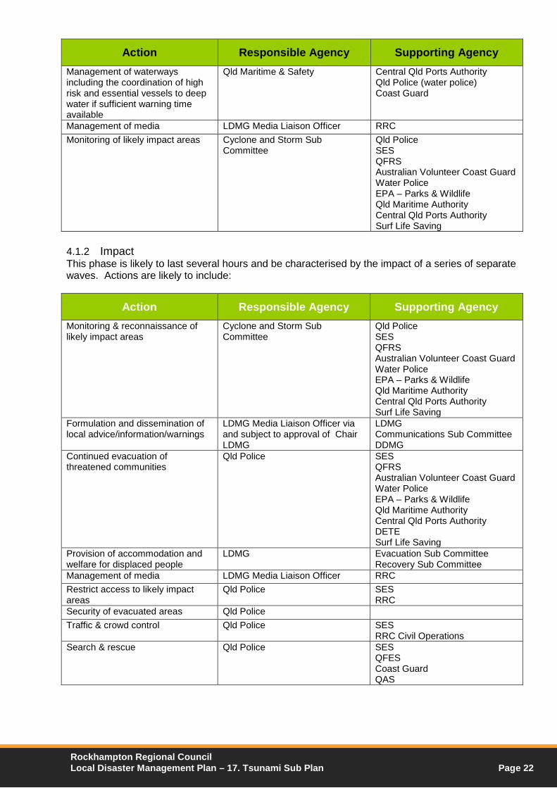
4.1.2 Impact This phase is likely to last several hours and be characterised by the impact of a series of separate waves. Actions are likely to include:
Action Responsible Agency Supporting Agency Monitoring & reconnaissance of likely impact areas
Cyclone and Storm Sub Committee
Qld Police SES QFRS Australian Volunteer Coast Guard Water Police EPA – Parks & Wildlife Qld Maritime Authority Central Qld Ports Authority Surf Life Saving
Formulation and dissemination of local advice/information/warnings
LDMG Media Liaison Officer via and subject to approval of Chair LDMG
LDMG Communications Sub Committee DDMG
Continued evacuation of threatened communities
Qld Police SES QFRS Australian Volunteer Coast Guard Water Police EPA – Parks & Wildlife Qld Maritime Authority Central Qld Ports Authority DETE Surf Life Saving
Provision of accommodation and welfare for displaced people
LDMG Evacuation Sub Committee Recovery Sub Committee
Management of media LDMG Media Liaison Officer RRC Restrict access to likely impact areas
Qld Police SES RRC
Security of evacuated areas Qld Police Traffic & crowd control Qld Police SES
RRC Civil Operations Search & rescue Qld Police SES
QFES Coast Guard QAS
Rockhampton Regional Council Local Disaster Management Plan – 17. Tsunami Sub Plan Page 22
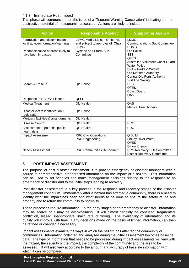
4.1.3 Immediate Post Impact This phase will commence upon the issue of a “Tsunami Warning Cancellation” indicating that the destructive potential of the tsunami has ceased. Actions are likely to include:
Action Responsible Agency Supporting Agency Formulation and dissemination of local advice/information/warnings
LDMG Media Liaison Officer via and subject to approval of Chair LDMG
LDMG Communications Sub Committee DDMG
Reconnaissance of areas likely to have been impacted
Cyclone and Storm Sub Committee
Qld Police SES QFES Australian Volunteer Coast Guard Water Police EPA – Parks & Wildlife Qld Maritime Authority Central Qld Ports Authority Surf Life Saving
Search & Rescue Qld Police SES QFES Coast Guard QAS
Response to HAZMAT issues QFES Medical Treatment Qld Health QAS
Medical Practitioners Disaster victim identification & registration
Qld Police
Mortuary facilities & arrangements Qld Health Disease Control Qld Health RRC Assessment of potential public health risks
Qld Health RRC
Impact Assessment RRC Civil Operations RRC Engineering
Q Build Fitzroy River Water QFES Ergon Energy
Needs Assessment RRC Communities Department RRC Recovery Sub Committee District Recovery Committee
5 POST IMPACT ASSESSMENT The purpose of post disaster assessment is to provide emergency or disaster managers with a source of comprehensive, standardised information on the impact of a hazard. This information can be used to set priorities and make management decisions relating to the response to an emergency or disaster and to the initial steps leading to recovery. Post disaster assessment is a key process in the response and recovery stages of the disaster management continuum. Immediately after a hazard has affected a community, there is a need to identify what the impact has been and what needs to be done to ensure the safety of life and property and to return the community to normality. These processes require information. In the early stages of an emergency or disaster, information may be scarce or it may be overwhelming. It will almost certainly be confused, fragmented, confliction, biased, inappropriate, inaccurate or wrong. The availability of information and its quality will improve with time. Early decisions made on the basis of limited information, can then be refined or changed if necessary. Impact assessments examine the ways in which the hazard has affected the community or communities. Information collected and analysed during the initial assessment becomes baseline data. The type of information that needs to be processed during impact assessments will vary with the hazard, the severity of the impact, the complexity of the community and the area to be assessed. It will also vary according to the amount and accuracy of baseline information with which it can be compared. Rockhampton Regional Council Local Disaster Management Plan – 17. Tsunami Sub Plan Page 23

When compiling impact assessment information, the information can include:
The area affected, by geographical location and size (with breakdowns into areas of severity if appropriate);
The major causes of casualties and damage; Human effects and casualties including the number of;
o People affected; o Deceased (and whether deaths are continuing); o Injuries and types (major or minor) and illnesses and people missing; o People who have had to evacuate or have been displaced and the places to
which they have moved; o People homeless or requiring shelter or evacuation
Damage including details of: o Homes destroyed or damaged; o Key community buildings destroyed or damaged; o Other buildings destroyed or damaged, including commercial premises and
suppliers of basic necessities to the community; o Lifelines and other key infrastructure; o Details of transport systems; o Agriculture and food supply systems; and o Key local economic resources such as industrial premises.
Identification of secondary hazards that may pose a threat in the immediate future; Sources, availability and purity of water for drinking and other purposes; Environmental health and sanitation threats; Availability of food supplies at family and community level; Available medical staff, facilities and supplies within the affected area and their
activities; Resources that have survived the disaster and might be usable in the response; The capacity of local government and emergency management structures to manage
the local response and recovery; and Government, community and other organisations operating in the area and their
activities. Needs assessments deal with the type, amount and priorities of assistance needed by an affected community after a disaster or emergency. Their purpose is to identify:
Needs of the affected community or communities to save and sustain life and reduce the risk of further damage and provide an indication of their urgency;
Needs that can be met from within the affected community and those that can only be met with outside assistance; and
Specialised needs of the affected community for recovery, the resources available to meet those needs from within the community and the external assistance that may be needed.
The information that should be sought during a needs assessment immediately after a disaster may include the personnel, resource and equipment requirements for:
search and rescue; medical evacuation; evacuation of survivors; medical and health support; environmental health; water supply and purification; shelter (including clothing, furniture etc); human (and animal) food (including storage, cooking, delivery etc): restoration of
lifelines; and delivery of assistance.
Rockhampton Regional Council Local Disaster Management Plan – 17. Tsunami Sub Plan Page 24
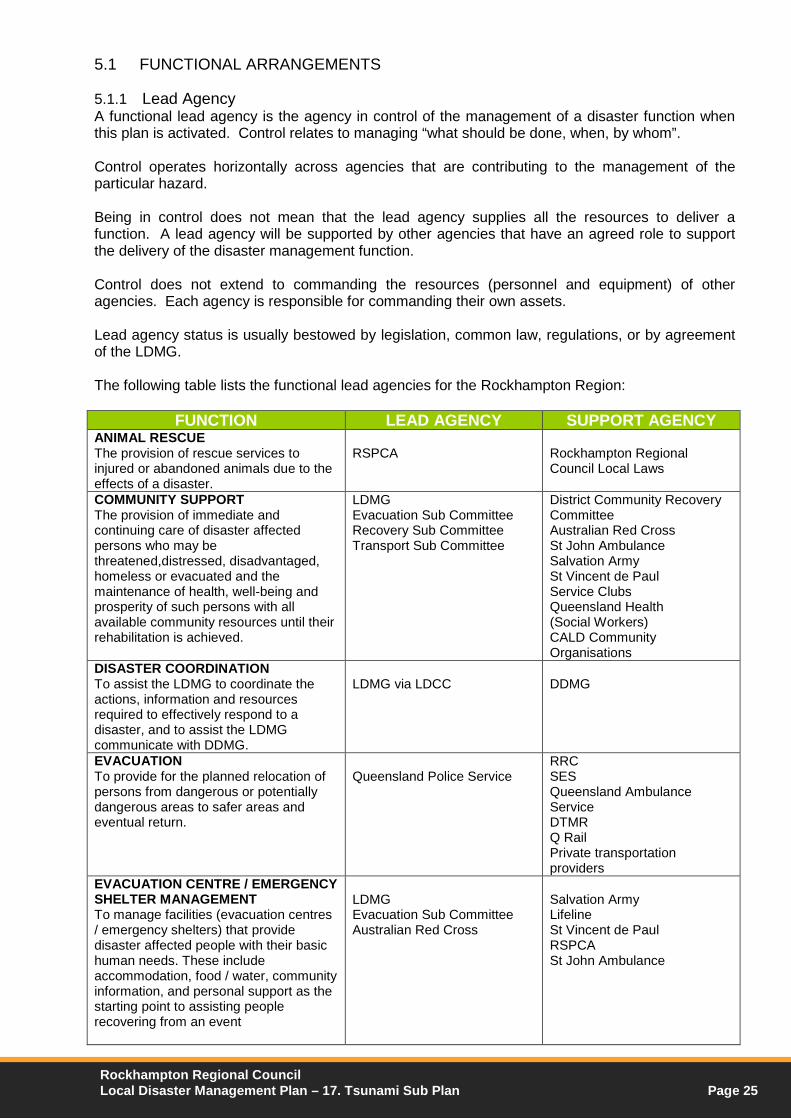
5.1 FUNCTIONAL ARRANGEMENTS
5.1.1 Lead Agency A functional lead agency is the agency in control of the management of a disaster function when this plan is activated. Control relates to managing “what should be done, when, by whom”. Control operates horizontally across agencies that are contributing to the management of the particular hazard. Being in control does not mean that the lead agency supplies all the resources to deliver a function. A lead agency will be supported by other agencies that have an agreed role to support the delivery of the disaster management function. Control does not extend to commanding the resources (personnel and equipment) of other agencies. Each agency is responsible for commanding their own assets. Lead agency status is usually bestowed by legislation, common law, regulations, or by agreement of the LDMG. The following table lists the functional lead agencies for the Rockhampton Region:
FUNCTION LEAD AGENCY SUPPORT AGENCY ANIMAL RESCUE The provision of rescue services to injured or abandoned animals due to the effects of a disaster.
RSPCA
Rockhampton Regional Council Local Laws
COMMUNITY SUPPORT The provision of immediate and continuing care of disaster affected persons who may be threatened,distressed, disadvantaged, homeless or evacuated and the maintenance of health, well-being and prosperity of such persons with all available community resources until their rehabilitation is achieved.
LDMG Evacuation Sub Committee Recovery Sub Committee Transport Sub Committee
District Community Recovery Committee Australian Red Cross St John Ambulance Salvation Army St Vincent de Paul Service Clubs Queensland Health (Social Workers) CALD Community Organisations
DISASTER COORDINATION To assist the LDMG to coordinate the actions, information and resources required to effectively respond to a disaster, and to assist the LDMG communicate with DDMG.
LDMG via LDCC
DDMG
EVACUATION To provide for the planned relocation of persons from dangerous or potentially dangerous areas to safer areas and eventual return.
Queensland Police Service
RRC SES Queensland Ambulance Service DTMR Q Rail Private transportation providers
EVACUATION CENTRE / EMERGENCY SHELTER MANAGEMENT To manage facilities (evacuation centres / emergency shelters) that provide disaster affected people with their basic human needs. These include accommodation, food / water, community information, and personal support as the starting point to assisting people recovering from an event
LDMG Evacuation Sub Committee Australian Red Cross
Salvation Army Lifeline St Vincent de Paul RSPCA St John Ambulance
Rockhampton Regional Council Local Disaster Management Plan – 17. Tsunami Sub Plan Page 25

FUNCTION LEAD AGENCY SUPPORT AGENCY IMPACT ASSESSMENT To assist the LDMG in planning, formatting, and conducting a complete initial impact assessment. This assessment gathers information on the magnitude of the event, and the extent of its impact on both the population and the community infrastructure.
RRC
All member organisations of the LDMG
MEDICAL SERVICES To provide coordination of the health and medical resources needed in responding to medical care needs following a disaster event.
Queensland Health
Private Medical Practitioners Day surgery facilities Private In-Patient Care Providers (Hospitals, Hospices, Nursing Homes) Private Domiciliary Care Providers Queensland Ambulance Service St John Ambulance Service
PUBLIC HEALTH To assist in the protection of the community, via temporary or preventative health measures to minimise the threats to public health.
RRC Environment and Health Unit
Queensland Health (Population Health Unit)
PUBLIC INFORMATION & WARNINGS To provide for the effective collection, monitoring, management and dissemination of accurate, useful and timely information and warnings to the public during disaster events
LDMG Communication Sub Committee
RRC DDMG Media – Social, Electronic & Print BoM Community Organisations
PUBLIC WORKS AND ENGINEERING To provide for the continuity of service of essential water and sewerage services, building inspections, road, rail, bridge and marine facility damage assessment, maintenance or repair, and demolitions and debris clearing as required
Asset Owners
RRC DTMR Queensland Rail DHPW
RESCUE Provide support to communities after a disaster event and to coordinate the use of resources in search and rescue in response to an actual or potential disaster condition.
Queensland Police Service
QFES SES QAS Australian Volunteer Coast Guard
RESUPPLY OPERATIONS To ensure that communities are re-supplied with food and other essentials during times of isolation
LDMG
Retailers Suppliers DDMG DHPW
TRANSPORT To coordinate the use of transportation resources to support the needs of local government, voluntary organisations and other disaster support groups requiring transportation capacity to perform their emergency response, recovery and assistance missions.
LDMG
RRC Air Carriers Marine carriers Private transport contractors Private companies with suitable heavy vehicles Voluntary agencies with transportation available Q Rail DTMR
Rockhampton Regional Council Local Disaster Management Plan – 17. Tsunami Sub Plan Page 26

5.1.2 Support Agency A support agency supports the lead agency in the delivery of a disaster management function through actions or the provision of personnel and equipment. While under the control of a lead agency, support agencies retain responsibility for commanding their resources and ensuring that their own standard operating procedures are correctly implemented. 6 RECOVERY
The primary aim of recovery is to assist the affected community to regain a proper level of functioning following a disaster both initially and in the long term (Queensland Audit Office 2004). Recovery is “the coordinated process of supporting emergency affected communities in reconstruction of the physical infrastructure and restoration of emotional, social, economic and physical well being” (Emergency Management Australia – Emergency Management Glossary 2004). The four elements of recovery are:
Community (including psychosocial recovery); Infrastructure (services & lifelines); Economy (including financial and political considerations and business
continuity); and Environment .
6.1 COMMUNITY RECOVERY
Community recovery involves the short-term health and well-being of the community, and the longer term returning of the community to normal functioning. This will include the need to provide information to the public through the media and other outlets to advise the local community of support agencies and services, and financial assistance available. 6.2 INFRASTRUCTURE RECOVERY
Infrastructure recovery involves restoring critical infrastructure, non-critical government and community infrastructure, and privately owned infrastructure. During a disaster event the LDMG will give first priority to reinstating the regions critical and essential infrastructure. Strategies to be implemented will include: 6.2.1 Water Services Water services will be reinstated, where possible, by RRC (FRW). If these services are not operating, public information/warnings will advise of alternative arrangements, which will depend on the condition of facilities and the availability of alternative sources for continuity of supply. 6.2.2 Sewerage Services Sewerage services will be reinstated, where possible, by FRW. If these services are not operating, public information/warnings will acknowledge the failure of the system and advise of alternative arrangements that should be followed to ensure public health and safety.
Rockhampton Regional Council Local Disaster Management Plan – 17. Tsunami Sub Plan Page 27

6.2.3 Roads and Bridges Restoration of local roads and bridges is the responsibility of RRC. Restoration of state and national roads and bridges is the responsibility of the Queensland Department of Transport and Main Roads. These agencies will be responsible for damage assessment of these assets, restoration works, implementing alternative routes and advising the LDMG and the public about conditions and alternate routes. 6.2.4 Buildings RRC will be responsible for inspection of and restoration of local government buildings. The Department of Public Works (DHPW) will be responsible for the inspection and restoration of state buildings. The restoration of privately owned critical infrastructure will be the responsibility of the asset owner. These agencies will be responsible for advising the LDMG of building conditions so that information may be distributed to the public where necessary. 6.3 ECONOMIC RECOVERY
Commercial and agricultural sectors of the region may be subject to losses including business disruption. The impact to local economic activity may cause hardship in terms of provision of services, food supply, communications and social dislocation. This will necessitate the provision of information to these sectors, through the media and other outlets to advise of support agencies and services, and financial assistance available 6.4 ENVIRONMENTAL RECOVERY
During disaster events there is great potential for environmental damage within the region. Both the natural and non-natural environment is vulnerable. This will necessitate the provision of information to the public, through the media and other outlets to advise of environmental impacts, dangers posed to the community and actions being taken to rectify such damage. All recovery issues are to be addressed as per the RRC Recovery Sub Plan. 7 MISCELLANEOUS ISSUES / ARRANGEMENTS
7.1 PURPOSE
To identify other important issues that are not covered elsewhere within the Cyclone and Storm Sub Plan. 7.2 OTHER SUB PLANS
Other Sub Plans have been developed for specific functions and should be referenced upon implementation of this plan. 7.3 POPULATION AND DEMOGRAPHICS
The Rockhampton Region is a multicultural society and includes numerous small towns and villages both along the coast and in the rural hinterland. A community profile is found in Annexure 7 of the LDMP. Reference should be made to this information during planning and response activities to assist in the decision making process during Tsunami events.
Rockhampton Regional Council Local Disaster Management Plan – 17. Tsunami Sub Plan Page 28

7.4 PUBLIC EDUCATION
Community awareness and education are critical to the successful implementation of a Cyclone and Storm Sub Plan in conjunction Tsunami awareness is also covered. Public education programmes shall be undertaken on a regular basis as determined by the LDMG to ensure community awareness and preparedness in regards to the effects and impacts of disasters or emergencies on the community. The Cyclone and Storm Sub Comittee is to ensure that such programmes include the need to evacuate under certain circumstances and specific action to be taken. 7.5 TRANSPORTATION
All transportation issues associated with cyclone and storm events will be undertaken in consultation with the Transport Sub Committee as per the Transport Sub Plan. 7.6 REVIEW AND ASSESSMENT OF PLANS
RRC may review or renew its Local Disaster Management Plan when it is considered appropriate (S59 DMA). However, there must be a review the effectiveness of the plan at least once a year. As such the Chairperson Cyclone and Storm Sub Committee should ensure that the Tsunami Sub Plan is appropriately reviewed and/or renewed. Assessment of the plan and response capability may be achieved through operational activation or by the conduct of exercises. When reviewing the effectiveness of the plan annually, a minimum of one practical exercise per annum should be undertaken, involving as many relevant organisations, authorities and stakeholders as possible. 7.7 PROTRACTED OPERATIONS
Should the affects of an event continue for a number of days or otherwise prolonged period, regular meetings of the LDMG will be held for the purposes of maintaining, co-ordinating and establishing operational priorities. The Chairperson of the LDMG will determine the frequency of such meetings. 7.8 CONCLUSION OF OPERATIONS (STAND DOWN) AND DEBRIEF
The Chairperson of the LDMG in consultation with the relevant Control Authority will determine at what time the stand down phase will be initiated to conclude an operation. Upon being advised of the conclusion of an operation the LDC will coordinate the recall of participating organisations and close down of the DDC. The Operations and Planning Officers within the DDC are to ensure that all completed forms and reports are collated and distributed through the LDC. The Officers in Charge of all participating organisations are to ensure that their members are debriefed. The Chairperson of the LDMG is to conduct an operation debrief of the Officer in Charge of the Control Authority and supporting organisations as soon as possible (and preferably within seven days) after the completion of the operation. Rockhampton Regional Council Local Disaster Management Plan – 17. Tsunami Sub Plan Page 29