observing the lunar libration zones (note: )users.telenet.be/lunar/jpeg/libratieboek.pdf ·...
TRANSCRIPT

Observing the Lunar Libration Zones
Alexander Vandenbohede
2005


Many Look, Few Observe
(Harold Hill, 1991)


Table of Contents
Introduction 1 1 Libration and libration zones 3 2 Mare Orientale 14 3 South Pole 18 4 Mare Australe 23 5 Mare Marginis and Mare Smithii 26 6 Mare Humboldtianum 29 7 North Pole 33 8 Oceanus Procellarum 37 Appendix I: Observational Circumstances and Equipment 43 Appendix II: Time Stratigraphical Table of the Moon and the Lunar Geological Map 44 Appendix III: Bibliography 46


Introduction – Why Observe the Libration Zones?
You might think that, because the Moon always keeps the same hemisphere turned towards the Earth as a consequence of its captured rotation, we always see the same 50% of the lunar surface. Well, this is not true. Because of the complicated motion of the Moon (see chapter 1) we can see a little bit around the east and west limb and over the north and south poles. The result is that we can observe 59% of the lunar surface. This extra 9% of lunar soil is called the libration zones because the motion, a gentle wobbling of the Moon in the Earth’s sky responsible for this, is called libration. In spite of the remainder of the lunar Earth-faced side, observing and even the basic task of identifying formations in the libration zones is not easy. The formations are foreshortened and seen highly edge-on. Obviously, you will need to know when libration favours which part of the lunar limb and how much you can look around the Moon’s limb. Before the space age, observing the libration zones was a hot issue because it meant observing uncharted territory. Nowadays, these zones have been photographed in great detail, so why observe these difficult regions? The answer is twofold. First of all, and a little bit of a cliché, it is still a challenge to observe and try to identify the different structures. After all, you’ll get to see a piece of lunar territory not many amateur astronomers and casual lunar observers will ever see. Secondly, the libration zones harbour some very interesting and unique formations. Observing the lunar libration zones means observing impact basins. This is not surprising since lunar geology is all about impact basins! Some fine and intriguing examples are situated in the libration zones. Take for instance the young Orientale impact basin. If this basin was situated on the near side of the Moon, we certainly would have grasped the concept of impact basins and its meaning for understanding lunar geology much earlier. Otherwise, the Humboldtianum impact basin is intriguing since it has a polygonal shaped outer ring but normal circular inner ring. The Australe, Smythii and Marginis basins are all very old and modified basin. They show us the complex evolution these old basins made from their formation, during the great bombardment up until now. Interestingly, the Smythii basin probably contains one of the oldest and one of the youngest lava sheets observable on the Moon. There is also the impressive Leibnitz Mountains forming the outer rim of the gigantic South Pole-Aitken basin, the largest impact basin in the solar system. The least interesting limbs to observe are the north-western part and the area around the north pole since they consist mainly of craters from which few details can be seen.
- 1 -

- 2 -
This portfolio bundles images of the libration zones and intends to be a guide for observing these regions. The Moon’s limb is therefore divided in seven zones. All images are made with amateur equipment, so everybody can observe what is illustrated here. A limited description of the libration zones and their geology is also given. The equipment used and the libration circumstances for the observations are given in Appendix I. A lunar timescale, to which the age of different structures is referred to, is given in appendix II. So, get your telescope tuned and check the ephemerides to observe the libration zones!

1 Libration and Libration Zones
Types of Libration It takes the Moon 27,3 days to complete one orbit around the Earth. This is about the same as the time taken for it to complete one rotation. This synchronous rotation would mean that the Moon always keeps its same side towards the Earth and that we would see only 50% of its surface. However, libration makes that we can see 59% instead of 50% of the lunar surface. We can see a little bit round the east and west limb and over the north and south pole. But how is this possible? There are four types of librations. The first is libration in longitude. It is a side-to-side wobbling of the Moon like it is saying no. Rotation of the Moons equals its revolution period around the Earth. The rotation around its axis is constant but the speed with which it orbits the Earth is not. This is a consequence of Kepler’s second law. The Moon’s orbit is not a perfect cycle but an ellipse. Therefore the speed around apogee is slower than the mean speed and quicker around perigee. For instance around apogee, its orbital speed is a little bit slower than that the Moon rotates along its axis. Therefore the western limb of the Moon is turned a little bit towards the Earth. At perigee, its orbital speed is a little bit quicker than that the Moon rotates along its axis and the western limb of the Moon is turned a little bit away from the Earth. As a consequence we experience a better look of the eastern limb.
Figure 1.1 Around perigee, the Moon is closer to the Earth and its orbital speed is thereforelarger. The opposite happens around apogee. At perigee the distance Earth-Moon is about 363263 km and at apogee about 405547km (National Maritime Museum, Royal Observatory Greenwich).
The second kind of libration is the libration in latitude. It is an up-and-down motion of the lunar disk as if it is saying yes. This is due to two factors: the ±5° inclination of the Moon’s orbital plane to the ecliptic and the ±1,5° inclination of the Moon’s rotational axis to its orbital plane. Therefore, at a certain point in its orbit the lunar north pole tips towards the Earth by as much
- 3 -

as 6°41’. At this time, we can see over the north pole. Half an orbit later, the north pole tips away from the Earth and we can see over the south pole. The third kind of libration is a parallax effect and is called the diurnal libration. It is caused by the changing position from which we see the Moon as an observer rotates along the Earth’s axis. It permits us t see a little way round the east limb of the Moon as it rises, and a little way round the west limb as it sets. Diurnal libration amounts to slightly les than 1°.
Figure 1.2 Libration in latitude is due the orientation of the lunar ration axis in space (National Maritime Museum, Royal Observatory Greenwich).
Also the Moon is not perfectly spherical. There is a slight bulging pointing towards the Earth. This is cause of the physical libration, manifesting itself as a very slight variation in the rate of the Moon’s rations about its own axis. It amounts to only 0,5” at the Moon’s centre, never to be noticed by a lunar observer.
Figure 1.3 Diurnal libration of the Moon is due to a parallax effect. As the Moon is rising, as is illustrated here, you can glimpse a little way round the eastern limb. A similar effect is present during sunset where we can see round the west limb (National Maritime Museum, Royal Observatory Greenwich).
Hunting Down the Lunar Motion and Libration Galileo (1564-1642) deserves the credit for discovering the Moon’s libration in longitude. Because of the synchronous rotation, Galileo proposed in 1632 that the centres of the Moon and the Earth were joined by a fixed line which always passed through a given point on the lunar surface. He announced this first in 1632. From observations of features on the limb and near the equator like Mare Crisium and Grimaldi, he knew that the Moon appears to sway gently from side to side. This is now known as the libration in longitude. At first, the though it was a parallax
- 4 -

effect due to the observer’s changing position relative to the Moon on a rotating Earth. In 1637, however, he noticed a corresponding libration in latitude and he had to abandon his idea of a fixed line between the centres of the Earth and the Moon. An attempt to visualise the libration zones was made by Hevelius (1611-1687). In his Selenographia of 1647, he gives a map of the Moon with an outline representing the lunar areas revealed by the extremes of libration. He tried to account for the libration in longitude. Hevelius assumed that the Moon moved in an elliptical orbit around the Earth with the latter in on of its focus. Instead of pointing towards the Earth, the centre of the lunar disk therefore is pointing towards the centre of this ellipse. He could not explain the libration in latitude since he assumed that the lunar axis is perpendicular to the ecliptic. Riccioli (1598-1671) also tried to show the libration zones on the moon map published in his Almagestum Novum of 1651. In 1687, Newton (1643-1727) showed that the libration in longitude is due to the fact that the Moon’s rate of spin on its axis is uniform, but its speed along its elliptical orbit varies in accordance with Kepler’s second law. Newton also was not successful in explaining the libration in latitude since he accepted the statement that the lunar axis is perpendicular to the ecliptic. Finally in 1693, Cassini (1625-1712) revealed the exact laws of the Moon’s rotation and was the cause for the libration understood. Observing the Libration Zones The east-west oscillation of the lunar disk in the night sky is called libration in longitude. If more of the eastern side of the Moon can be seen, the libration in longitude is positive, otherwise it is negative. This can be as much as ±7,95°. The north-south oscillation is called libration in latitude. If more of the northern side of the Moon can be seen, the libration in latitude is positive, otherwise it is negative. This can be as much as ±6,85°. Features at the lunar disk’s limb regions, also called the libration zones, are visible under different conditions because of the libration. Libration also influences the position of the terminator.
Figure 1.4 Visualisation of libration in longitude and latitude and the libration angle. In the figure at right, longitudinal and latitudinal libration are positive bringing the north-eastern limb in a favoured view.
5

Libration in longitude and in latitude can be calculated for an observer positioned in the centre of the Earth, being the geocentric libration. Obviously, an observer is positioned somewhere on the Earth’s surface altering the libration in longitude and latitude as seen by him or her slightly. Additionally, there is also the parallax effect. Libration for an observer’s position is called the topocentric libration. It is the geocentric libration corrected for the of-centre position of the observer on the Earth and taking into account the parallax effect. Given a certain date, one position on the moon’s limb is favoured because of the libration. This position is indicated by what is here called the topocentric/geocentric lib ation angle. It is the angle from the north of the lunar disk, clockwise towards the favoured position. The number of degrees you can look round the limb at this position is here called the total libration.
r
Figure 1.5 Libration, phase coefficient and colongitude for January 2005.
Figure 1.5 shows the libration, phase coefficient and colongitude for the month January of 2005 for the author’s observing location in Brugge, Belgium (long=50,2167°, lat=3,2167°). This is the kind of data and representation of it that the author, based on self-written programs, use to prepare observations. These data should also be found in any good celestial almanac. The upper left figure (longitudinal versus latitudinal libration for the month) is the most used representation of the data. The upper right and lower left figure is more practical for the observer. The longitudinal and latitudinal libration is given in function of time. It can be clearly seen that both are changing more or less regularly (almost like a wave) in time. What you see as an observer, however, is that one part of the lunar limb is tilted towards you. Therefore, only the libration angle and the total libration (sum of longitudinal and latitudinal) are important. Notice also the difference between the geocentric libration (dotted lines) and the topocentric libration (full lines).
6

left: topocentr. lib. long: -6,29, lat: -6,18, angle: 225,5 (27/04/2004, 2100 UT) right: topocentr. lib. long: 6,01, lat: 5,65, angle: 46,8 (20/11/2004, 2000 UT)
Figure 1.6 The effect of libration is here dramatically illustrated by Mare Crisium and Mare Marginis. On the left, Mare Marginis is not visible at all and Mare Crisium is much more foreshortened. During January 2005, the Moon is in its perigeum on the 10th and in its apogeum on the 23th. This can be seen on figure 1.5 since the libration in longitude reaches respectively its maximum and minimum value. Notice also that the topographic libration in latitude is always larger than the geocentric libration in latitude due the northern position of Brugge (Belgium). The phase coefficient and the colongitude are also calculated because they are essential. For instance, around the 15th of January the total libration is largest during this month. The libration angle is about 60°, meaning that the north-eastern limb is favoured. Question is if this part of the Moon is then visible. Figure with the phase coefficient shows that it is then between new moon and first quarter. The favoured region is thus well visible, as a bonus it is also relatively near the terminator meaning that shadow can be seen in the area. Figure 1.7 shows the librations and libration angle during the period 19 to 22 January. The effect of diurnal libration is well illustrated here. For instance the Moon rises at 11h34 UT on the 20th. Then the eastern limb is favoured maximally because of the diurnal libration and the libration in the topographic libration in longitude must be larger than the geocentric libration in longitude. The reverse is true during the setting of the Moon. Topographic and geocentric libration are equal when the Moon culminates in the sky.
7

Figure 1.7 Libration and libration angle for the period 19 to 22 January 2005. The time of rising, culmination and setting of the Moon during the 20th is indicated. How Much Can We Look Round the Limb? Libration is given in degrees. Now if the total libration is for instance 5°, how many kilometres can you then look round the lunar limb? Well, this is presented in figure 1.8.
Figure 1.8 The distance one can look round the lunar limb in function of total libration.
8

Libration and Geographical Location Figure 1.9 shows how the libration on different geographical locations for the first 10 days of January 2005. Some interesting features about libration can be learned from this figure. For instance, diurnal libration is zero on the poles, the north pole in this case, because there is no parallax effect. The difference between geocentric and topographic libration is solely due to the
Figure 1.9 Libration on different positions on the Earth during the first 10 days of January 2005
9

of-centre position of the observer. The oscillations due to the diurnal libration are increasing on lower latitudes and are maximal for an observer on the equator. On the equator, the parallax effect is indeed the largest. Comparing two positions which are located on the same latitude but not on the same longitude, the parallax effect is the same in magnitude but not in timing since the Moon rises and sets on different times. Different Libration Circumstances During Lunations The complex motion of the Moon makes that libration circumstances are constantly changing, no two lunations are the same. Figure 1.10 shows the librations during July 2003. We can look at the fluctuations in time of the libration in longitude and latitude as a wave with a maximum, minimum, amplitude and wavelength. In this case, the two waves are almost in phase, meaning that the maxima of libration in longitude and latitude occur almost at the same time. This has its implications for the total topographic libration we observe and which we are interested in. First, total libration varies considerable during the month, ranging from slightly larger than 0° to almost 10°. Secondly, only two limb regions are favoured by the libration. This is due to the fact that when libration in longitude is altered by a certain amount, the libration in latitude is also altered by almost the same amount. The number of degrees you can see around the limb (total libration) changes but not the libration angle. So, if you would observe the Moon day after day, you would see that the same part of the Moon is tilted more towards you than the day before and another part (on the other side of the lunar disk) is tilted away from you. For instance, in the beginning of July 2003 the southwest limb is favoured. Libration is maximum on the 2th after
Figure 1.10 Libration during July 2003 for an observer in Brugge (Belgium).
10

which this region is tilted back towards the observer. Then around the 10th libration is minimal (almost 0°) meaning that none of the libration zones can be observed. In the time span of one to two days, libration angle changes drastically (more or less over 180°) and from then on the northeast limb is tilted towards the observer, every day a little more until a maximum is reached around the 17th. The Moon is then tilted back towards the observer until again a drastic change in libration angle occurs. Thus, during the month you can see the moon swivel from one side to the other. Here this is from southwest to northeast and back again. The same situation occurs when a maximum and a minimum of the libration in longitude and latitude occur around the same time. Another interesting situation is visible during May 2004. Here a maximum or minimum in libration in longitude or latitude coincides more or less with 0° libration in latitude or longitude. Result is that the total libration does not vary much during the month and is in general quite small. Libration angle does change constantly in function of time. The favoured limb region moves with almost a constant amount per day clockwise around the lunar disk. So, from day to day you would see the lunar disk wobble around in the sky.
Figure 1.11 Libration during May 2004 for an observer in Brugge (Belgium).
According to the interaction of libration in longitude and latitude, libration circumstances evolve from lunation to lunation between these two extreme situations illustrated. This complex interaction makes that the same situations of libration and lightening only occur with a frequency of 18 years, 10 days and 8 hours, the so called Saros period. Note that if you wait one Saros period, you will most probably not be able to observe the Moon due to the 8 hours. Assume for instance that the Moon is high in your sky reading this. One Saros period later, the Moon will most certainly be below the western horizon. This is due to the fact that the Earth will have rotated during an extra 8 hours. It means that when you observe from Europe, one Saros later
11

you’ll have to travel to America to observe under the same conditions. Staying in Europe, you’ll have to wait 3 Saros periods or 54 years and 31 days. The changes to see the Moon under identical circumstances are therefore minimal. Every observation of the Moon is truly unique! Portfolio of the Libration Zones: equipment and techniques The images found in this portfolio were made with a webcam, a Philips ToUcam Pro. Two telescopes wee used. The first is a 20 cm F6 Newton on a dobsonian mount. The second telescope is the excellent 20 cm F15 refractor of the public observatory of Beisbroek. All observations were done from the author’s backyard in Brugge (Belgium) or in the nearby Beisbroek public observatory. Details about the equipment used for the pictures in this portfolio can be found in Appendix I.
Figure 1.12 To make the p ctures in th s portfolio, two telescopes were used. The first is a 20 cm F6 Newtonian telescope on a Dobsonian mount (left) of the author. The second is the 20 cmF15 refractor of the public observatory of Beisbroek (right) near Brugge.
i i
Figure 1.13 All images are made with the Philips ToUcam Pro webcam, here seen on the Dobsonian mounted reflector.
Combination of the webcam and the refractor leads to a field of view of 4,1 x 3,1 arcmin1. Combination of the webcam and the Newton leads to a field of view of 10,2 x 7,7 arcmin. The latter has a larger field of view and therefore larger parts of the Moon can be imaged. Due to 1 field of view of the ToUcam (arcmin) = 3438 x side length of the CCD chip (mm) / effective focal length of the imaging system (mm) side length of the CCD chip is 3,58 x 2,69 mm with 640 x 480 pixels
12

the detail which can be photographed with webcams, this combination results in detailed overviews of the libration zones. The refractor-webcam combination allows taking more detailed pictures of the Moon. Digital revolution in astrophotography makes is possible to quite easily combine different pictures in mosaics. This is done for almost any picture in this portfolio so that the structures in the libration zones can be seen in their wide field (geological) context. Digital revolution made another interesting technique available for observers of libration zones in particular, but also Moon and planets in general. Hartmann discovered the true nature of the impact basins by examining Earth-based photographs projected onto a sphere. The multiring appearance of the Orientale impact basin was dramatically visualised in that way. Nowadays a similar exercise can be made on the computer. A picture of the Moon can be digitally projected on a sphere. This sphere can then be tilted in any direction to get fascinating different views on the photographed lunar features. Obviously, this is a very interesting tool for an observer of the libration zones. Therefore, most images in this portfolio are rendered in this way.
Figure 1.14 Techniques can be applied whereby a lunar image is digitally projected on a sphere. This opens then the possibili y to tilt this sphere in all directions. For instance here, the lunarimage in the top right panel is tilted so that the eastern limb regions, the north pole and thesouth pole can be better seen.
t
13

2 Mare Orientale
The Orientale impact basin is situated along the south-western limb of the Moon. It is the youngest impact basin on the Moon and provides observers an example of a fresh multiring basin. It gives us a good idea how for instance the Imbrium impact basin would look like without its lava cover. With good libration, most of the structures typifying the basin are visible. Most conspicuous are three large mountain rings forming the three main rings of the impact basin. The Montes Cordillera defines the outer (diameter of 930 km) of the three main rings and is easily visible. Notice the scarp facing towards the basin’s centre. The other side of the Montes Cordillera fades more gradually in the surrounding terrain. The largest peaks have a height of 1,25 km. The Outer (or Montes Rook, ring diameter of 620 km) and Inner Rook Mountains (diameter of 480 km) are two rings of mountains inside the Montes Cordillera. Lacus Autumni and Lacus Veris are two dark patches of lava between the Outer Rook Mountains and the Montes Cordillera. This lava leaked to the surface along deep fractures associated with the basin formation. Between the Outer and Inner Rook Mountains another dark patch of lava, Lacus Veris, can be seen. Inside the Inner Rook Mountains, there is another incomplete and not well defined ring (diameter of 320 km). No name has been appointed to this structure. Inside this, there is a dark patch of lava which forms the centre of the impact basin. This is called Mare Orientale. The name Mare Orientale refers thus only to a small portion of the Orientale impact basin. This confusion is a relict of earlier times when scientists and observer were not aware of impact basins and its meaning for lunar geology. Mare Orientale is a depression about 6 km lower then the highest peaks in the Montes Cordillera. This relief can be beautifully seen in profile along the Moon’s limb. The topography of the basin is best seen when the terminator is positioned in the basin, which is in combination with favourable libration and good seeing a rare coincidence. With a higher Sun, most conspicuous are the dark lava patches between the mountain ranges and in the basin’s centre. Some crater in and around the basin are worth looking for, for instance Schlüter, Eichstadt (49 km, Ec1), Krasnov (44 km), Wright (36 km) and Shaler (44 km) are founded along the Montes Cordillera. Pettit (36 km) and Nicholson (36 km) are situated along the Montes Rook. South of the Montes Cordillera some very nice valleys can be seen: Vallis Bouvard, Vallis Baade and Vallis Inghirami. They are pointing away from the impact basin and are formed by its immense ejecta blanket. But even if conditions are favourable it is difficult to see the true grandeur of the basin due to its foreshortening. The true multiring nature of the basin was discovered by Hartmann by examining Earth-based photographs projected onto a sphere. Nowadays a similar exercise can be made on the computer revealing the impact basin and all its features as it could only be appreciated from orbit around the Moon. In this way it can be very well seen that the Montes Cordillera and the Inner and Outer Rook Mountains are concentric mountain ranges. Even a fourth, albeit less prominent ring, can be seen. This one is situated west of Grimaldi and the Byrgius A ray system and east of Baade near the terminator. This ring is very difficult to see in the telescope.
1 Age of the structure referring the lunar stratigraphic table, see Appendix II.
- 14 -

Rare coincidence of favourable libration and the terminator positioned in Mare Orientale (04/04/2004).
- 15 -

The termina or has not as far proceeded in the Orientale impact basin as on the previous observation. Here (24/01/2005) terminator is positioned in the Montes Rook and therefore, the topography of the area between the Montes Cordillera and the Montes Rook can be better appreciated from this view. This is not featureless area!
t
- 16 -

Under a high Sun, the dark lava patches mark the position of the Orientale impact basin (04/12/2004). Notice also the beautiful ray system of Byrgius A with two long rays pointing towards Mare Orientale. Lower panel shows the image rendered.
- 17 -

3 South Pole
The area around the south pole is part of the lunar highlands. It consists of a much cratered and mountainous landscape with no vast mare plains in it. This means that there are no dark albedo features as landmarks and usable as guidance in the area. During full moon, it is very difficult to identify craters and mountains, so opportunities must be awaited until the terminator is situated in the area and the libration is spot on. On these rare occasions, you get an extraordinary view of the rim of the largest lunar basin and of a famous piece of lunar soil. The Leibnitz Mountains (not an official IAU name) are a huge chain of isolated mountains and mountain ridges stretching for nearly 30° along the Moon’s limb. As soon as was recognised by Hartmann and Kuiper that mountain ranges are actually the rims of impact basins, they proposed the presence of an enormous impact basin on the lunar far side. The Leibnitz Mountains are then part of this giant multiring basin. It was only with laser sensors measurements of Apollo and especially of Clementine that this basin was confirmed. This South Pole-Aitken basin as it is now known, has a diameter of 2500 m and is over 12 km deep in some places. It is the largest impact basin of the solar system. A few of the mountain peaks are numbered (M1 to M6) or named (Leibnitz β, δ, ε, and γ) on Whitaker’s 1954 map(and on of the best) of the area. M1 is just in front of the crater Cabeus, and M3 is slightly behind and east of the crater. Whitaker suggests that M1 rises 6 to 7.5 km above its surroundings, and M3 is slightly lower at 4.5 to 6 km. Just beyond the pole (but visible with good illumination and libration) are two additional massive peaks, M4 and M5 (which rises to 9 km). Mountain M5 is also informally named Mount Clementine and is one of the tallest peaks near the south pole. It is exposed to sunlight more than 90% of the time. Photography of the Moon with the Orbiter IV and V and the different Apollo missions covered about 99,3% of the lunar surface. The remaining 0,7% was not adequately photographed because it was illuminated by very low solar lighting and large areas were obscured by shadows. It is an area of about 105 000 square miles in the vicinity of the south pole. It is the libratory south-south west region around the south pole and south of the craters Drygalski and Hausen and became known as Luna Incognita. A program was set up by the Association of Lunar and Planetary Observers, inspired by John Westfall, to map the region in 1971. Now, although Luna Incognita is photographed in great detail by the Clementine and Lunar Prospector missions, it remains a challenge for observers to get a view of this once legendary piece of lunar soil. Some large craters can be found in the vicinity of the south pole. Hausen and Drygalski are two of the largest examples. Hausen (Cc2) is an impressive crater with a diameter of 180 km and is found behind Bailly. Drygalsi is slightly smaller (176 km, pNc) and has a complex central mountain ridge. Cabeus (96 km, pNc) is a crater with high and eroded walls. Malapert(54 km) is an irregular crater with eroded walls. Schakleton is a small crater but is interesting to look up because the south pole is situated inside it. Scott (108 km, pNc) and Demonax (114km, Nc) are two large craters which are easily recognisable. They act therefore as an ideal starting point to explore the south pole region. Not only the craters of the southeast quadrant of the Moon are interesting, also the area between craters. These intercrater plains are intriguingly smooth. Perhaps they are similar to mare but are therefore too bright. Or perhaps it are bright lava
- 18 -

flows or even part of the original crust predating the mare. Another, and the most likely hypothesis, is that a mantle of impact debris formed the smooth intercrater plains. A last interesting feature to look up is the Doerfel Mountains. They are a couple of mountains which can be seen behind Bailly (303, pNc). The exact identification of the peaks is difficult. They appear not to be part of a mountain range but being high spots on the rims of Bailly, Hausen and the Atiken-South Pole Basin. Therefore, the name Doerfel Mountains, given by Schröter in the late 1700s was dropped from the Moon's official nomenclature.
- 19 -

Top picture gives an overview of the Leibnitz Mountains and Luna Incognita (26/12/2004). Detail of the Leibnitz Mountains with indication of different peaks according to the maps of Whitaker 1954) is given in the middle panel. In the lower panel, the area is tilted artificially towards the observer.
- 20 -

Observation on 23/02/2002 gives a detail of mountain peak M1 of the Leibnitz Mountains. A number of brilliant peaks can be seen along the southern part of a crescent moon (06/04/2003). These are the highest peaks of the Leibnitz Mountains catching first light, long before the lower parts of the mountains. The lower panel (09/09/2004 shows the Doerfel Mountains behind the large crater Bailly.
)
- 21 -

t
Terminator position and libration favours view of the south pole region (24/01/2005) although under different condi ions than on 26/12/2004.
- 22 -

4 Mare Australe
Mare Australe consist of a number of mare patches. Lunar Orbiter photographs revealed that these mare patches on the floors of nearly 200 craters define a circular area about 900 km in diameter, presumably delineating an ancient impact basin. But unlike other impact basins, no concentric rings or ejecta deposits could be detected. So it was thought that the Australe basin was very old, pre-Nectarian, and likely different from any other know lunar basin. It originated very early in lunar history and should have looked like any other impact basin, e.g. the Orientale basin. Pre-Nectarian and Nectarian times were still the era of an intense bombardment destroying much of the structures of the Australe impact basin. Later, lava rose up through the basin faults filling the craters within the old basin. Some of these craters were only partially filled by the lava, others completely. Mare Australe thus provides us an intriguing look at the development of an impact basin dating from the earliest times of our Moon. Under a high Sun, the position of Mare Australe is easily found by the numerous patches of dark lava filling the craters. A low Sun ads relief to the scenery and the smoothness of the crater fillings and low rims can be appreciated. Oken (72 km) and Lyot (141 km) are two easily recognisable craters. The crater walls of both are highly eroded by later impacts. Lyot is believed to be of Pre-Nectarian age and Oken of Nectarian age. Hamilton (57 km) is an Eratosthenian aged, bright impact crater, situated towards the centre of the Australe impact basin. Situated northwards from Mare Australe, Humboldt (207 km, Ic2) is a beautiful example of a floor fractured crater. These are large craters whose original impact floors have been modified by volcanic activity and fracturing. The fracturing of the Humboldt’s floor is very hard, not to say impossible, to see from Earth, the result of volcanic activity is eye-catching under a high Sun. Then dark patches of lava can be seen along the edges of the crater floor. Humboldt also has an impressive central mount complex. A crater chain, Catena Humboldt, can be found west of Humboldt. This is barely recognisable on the rendered images. Other craters worth looking up are Abel (116 km, pNc), Barnard (120 km, pNc), Phillips (101 km), Hecataeus (127 km, pNc), Gibbs (81 km, Nc), Behaim (56 km, Ic1), Ansgarius (90 km, Ic1) and la Pérouse (78 km, Ic2).
- 23 -

Mare Australe seen under low Sun (upper panel) and under a high Sun (lower panel). The rendered images clearly show the circular arrangement of the dark lava filled craters illustrating the basin like nature of the mare.
- 24 -

High (upper panel) and low (lower panel) Sun view of the area between Mare Australe and MareSmythii.
- 25 -

5 Mare Marginis and Mare Smythii
On the limb, east of Mare Crisium, a patch of mare appropriately named Mare Marginis can be observed. Mare Marginis is about 200 km long from north to south and dates from the pre-Nectarian. Its lava is lighter hued in comparison with the nearby Mare Crisium. Mare Marginis is one of the oldest impact basin and maria on the Moon. A large number of craters are therefore superposed on it. The multiring nature of Mare Marginis is hardly recognisable. Lava has almost completely filled the basin and many impact craters. Goddard (90 km, pNc) is such a lava filled crater. North of it a bright spot can be observed. This is not a part of the ejecta blanket of Goddard but part of a set of bright swirls that extend from the lunar far side. A well-known example on the near-side of the Moon is Reiner gamma in Oceanus Procellarum. The swirls in Mare Marginis are highly magnetised and lie antipodal to the Orientale impact basin. Neper is a 137 km wide Tycho-like crater of Nectarian age. At full moon its central mountain complex stands as a white beacon in the grey of the crater floor. Between Mare Marginis and Mare Crisium are a few patches of lava which, curiously enough, have no name. Their outlines reminded Whitaker to the smile of the Cheshire Cat in Alice’s Adventures in Wonderland. Therefore it became known as Lacus Risus Felis or cat’s smile lake. Unfortunately, this beautiful name is no official nomenclature. Mare Smythii (pNc), situated south of Mare Marginis, is definitely still recognisable as a multiring impact basin. The inner ring diameter which can be easy seen under a low Sun has a diameter of 350 to 400 km. The basin floor is about 6 to 8 km below the highest rim. This is relatively deep in comparison with its diameter making it one of the lowest maria on the Moon. When librations put the mare right on the limb, a flattening of this limb can be observed. Under a high Sun, it can be seen that parts of the mare are darker than other parts suggesting that there are two different ages for the lavas. The northern part of the floor is the darkest and formed more recently, presumably only about 1 to 2 milliard years ago. The southern part has a large number of superimposed craters, indicating its high age. Thus one of the oldest and one of the youngest mare surfaces can be found in one basin.
- 26 -

Mare Marginis and Mare Smythii seen under a high Sun (19/12/2004). On the lower panel, the circular outline of Mare Smythii is obvious. Mare Marginis is far more irregular.
- 27 -
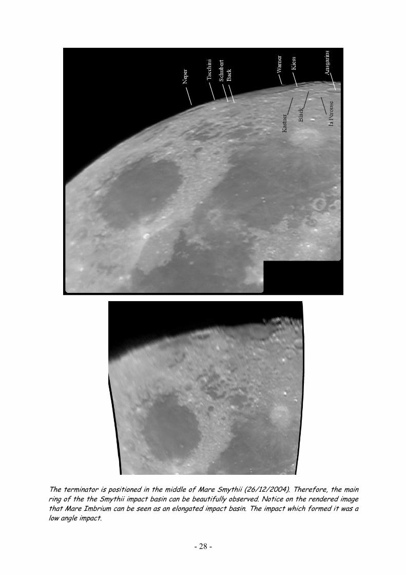
The terminator is positioned in the middle of Mare Smythii (26/12/2004). Therefore, the mainring of the the Smythii impact basin can be beautifully observed. Notice on the rendered image that Mare Imbrium can be seen as an e ongated impact basin. The impact wh ch formed it was a low angle impact.
l i
- 28 -

6 Mare Humboldtianum
The north-eastern part of the Moon is dominated by the impressive Humboldtianum impact basin of pre-Nectarian age. Mare Humboldtianum is one of only two maria named after a person. This was done by Mädler in honour of Alexander von Humboldt who explored uncharted regions of the Earth. If librations are favourable, Mare Humboldtianum is easily found as a dark patch along the limb next to a 125 km wide and mare floored crater Endymion. The mare material in the impact basin is about 160 km wide and it is contained within a 300 km wide inner basin rim. This rim in turn is surrounded by a 600 km diameter outer rim that stretches from north of Endymion around the limb towards the lunar farside. The northern part of this rim is unrecognisable due to more recent impacts. The centre part of the mare is about 4.2 km lower than the basin edges according to Clementine altimetry data. Interestingly, the inner, mare-girding rim is circular, whereas the main outer basin rim is made up of three linear segments. Why is this outer rim so angular? This angularity is not unique since there are many examples of craters whose crater rims are polygonal rather than circular. The most likely possibility is that when the Moon was very young it was much closer to the Earth and hence strong tidal forces generated a system of orthogonal stresses. As impact craters formed these stresses controlled the orientation of rims and polygonal walls were formed. But then why is the inner Humboldtianum rim circular, while the outer rim is strongly angular? Both must have formed at the same time - although the inner rim may be more like an enlarged central peak formed by rebound, whereas the outer rim may be more like a crater rim formed by collapse into the impact transient cavity. There is still much to learn about lunar geology! Some interesting features can be seen within the Humboldtianum impact basin. Belkovich (198 km) is a large crater of Nectarian age situated in the northwest part of Mare Humboldtianum. Its rims are highly eroded. The relatively young crater Hayn (87 km, Cc) is found on the northwest rim of Belkovich. The north-western part of Mare Humboldtianum is covert by light hued material. This is part of a bright ray which can be followed towards Geminus, passing west of Mercurius and Lacus Spei. South of Mare Humboldtianum lies the Nectarian aged crater Gauss (177 km). If it wasn’t situated on the Moon’s limb, this large crater with its smooth floor cut by rilles would be a fascinating sight. At full moon, dark patches can be seen in some craters (Bernoulli, Berosus, Hahn, Messala, Gauss and Mercurius) and between the craters (Lacus Spei). Some of these spots are volcanic dark halo craters, where impacts have excavated deeper volcanic material, and some must be genuine mare patches.
- 29 -

Sunrise over the Humboldtianum impact basin, photographed on 13/01/2005. The rendered image on the lower panel shows the structure of the impact basin with the circular inner ring and the polygonal outer rim indicated with a dashed line.
- 30 -

North-eastern moon limb under high Sun (20/11/2004). Notice the bright ray going from Mare Humboldtianum towards Geminus and the dark patches in and between some craters.
- 31 -

More detailed view of the Humboldtianum impact basin and its surroundings (15/01/2005).
- 32 -

7 North Pole
The north pole does not provide spectacular glimpses on impact basins and giant mountain ranges as shown in the previous chapters. At first sight, it only provides foreshortened views on craters which are difficult to identify and difficult to observe any detail of. Instead of observing only the libration zones around the north pole, it is therefore much more interesting to observe the whole region between the north pole and Mare Frigoris. For whatever kind of reason, this is a region on the Moon which is often wrongfully overlooked. It contains a number of fantastic craters. Take for instance Gärtner (102 km, pNc) which is strongly eroded and invaded in the south by lava from Mare Frigoris. Its floor also contains a small rille, the Rima Gärtner. Other examples situated in the north-eastern part of the region are de la Rue (135 km, pNc), Thales (32 km), Strabo (55 km, Nc), Democritus (39 km), Arnold (95 km, pNc), Cusanus (63 km, Nc), Peterman (73 km, Nc), Nansen (110 km, pNc), Baillaud (89 km, pNc), Euctemon (62 km, Nc) and de Sitter (65 km, pNc). More central we find Scoresby (56 km Ec), Main (51 km), Challis (56 km, Nc) and W. Bond (157 km, pNc). To the west, we find Goldschmidt (125 km, pNc), Anaxagoras (51 km, Cc), Mouchez (82 km, pNc), Philolaus ((71 km, Ec) and Anaximenes (80 km, pNc). Some craters deserve some further attention. Thales is centre of a peculiar bright asymmetric ray system. It has the form of an hourglass with one bright part situated southwest of the crater and another bright part situated northeast of Thales. This is due to an oblique impact. Anaxagoras is another fine example of a bright ray system. It provides us an oblique view of a Copernicus type crater and ejecta deposit. Thales and Anaxagoras are testimony of the last large impacts in this region. Meton (122 km) is a remarkable crater of pre-Nectarian age. It consists of a number of craters which form one big crater. The whole complex has a smooth floor. This material is not lava but rather brighter ejecta from the nearby Imbrium basin. This would also explain why its rims are highly eroded. Arnold and Baillaud are similar examples. Notice that many craters are degraded. These morphologies are part of the lunar wide Imbrium sculpture. This very easy to observe south of the Imbrium basin but difficult to do so in the north pole region due to the foreshortening. Intriguingly, some of these old craters have very smooth floors (Meton, Baillaud and Arnold) while others are very rough (W. Bond, J. Herschel). Crater chains are another example of the Imbrium sculpture. Two such crater rays are visible in the north pole region but they are relatively difficult to recognise if you don’t now what you are after. The first is visible between the craters Archytas and W. Bond. The other starts from Schwabe and is oriented towards the lunar limb. Try to find them, only a handful of lunar observers have actually seen these two crater chains.
- 33 -
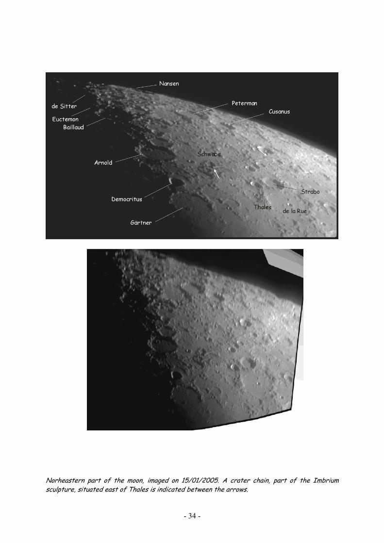
Norheastern part of the moon, imaged on 15/01/2005. A crater chain, part of the Imbrium sculpture, situated east of Thales is indicated between the arrows.
- 34 -

Lunar phase favours observing topography of the central area around the north pole on 04/09/2004.
- 35 -

Detail of the area around crater W. Bond (upper panel), and the ray systems of Anaxagoras (middle panel) and Thales (lower panel). Arrows in the upper panel locate the crater chain between W. Bond and Archytas.
- 36 -

8 Oceanus Procellarum
As was the case for the north pole, the north-western limb region bordering Oceanus Procellarum mainly offers foreshortened views on craters. Some of these craters deserve detailed observation. We will not only look to the libration zone but also the adjacent Oceanus Procellarum since some very interesting craters are observable. Krafft and Cardanus (Ec), for instance, are two similar sized craters, about 50 km in diameter. They look very alike under a low Sun. When the Sun is higher, Krafft is hard to make out except for a small bright crater on its floor. Cardanus is conspicuous with its bright rim crest and inner walls. Both craters are surrounded and partially overlapped by lavas from Oceanus Procellarum. A closer look at Cardanus reveals that part of its ejecta covers older mare material to the south. Cardanus appears to have formed between successive eruptions in Oceanus Procellarum. A remarkable feature is present between the two craters. They are linked by a linear rille, Rima Krafft, made of overlapping craters. Lunar Orbiter photographs identify it as a crater chain continuing onto the floor of Krafft. It must be secondary crater chain but from which crater? It is not radial to Cardanus yet could not have come from anywhere else. This limb region is also the fascinating to study ray systems. A peculiar ray extends from near Cardanus, passes Seleucus and skirts the northern end of the Aristarchus plateau. The ray is very atypical and is perhaps composed of unrelated ray segments. The south-western end of the ray is broken and not very straight and is probably emanating form Olbers A. Between Cardanus and Seleucus, the ray bends in a shallow arc opening to the northwest and then abruptly straightens and heads north-easterly across Oceanus Procellarum for another 400 km. Individual linear segments in the bend are radial to Olbers A. Another ray segment passes south of Seleucus, grazes Schiaparelli, and disappears at the Aristarchus plateau. This ray has no obvious source. Another strange ray appears as a straight line stretching from near the small crater Briggs B to the south of Lichtenberg. This ray was appointed to a small crater south of Struve by Franz in the early 20th century. Lunar Orbiter imagery indeed revealed a fresh ray crater, Ohm at 113°W and 18°N. Russell (99 km, pNc), Struve (183 km) and Eddington (134 km, pNc) form a mighty trio on the borders of Oceanus Procellarum. All three are ruins that have been flooded by mare lavas that invaded along their southern walls. Struve appears to have been already shallow before this lava activity. Its floor is very rough due to secondary craters and striated terrain. This is probably due the ejecta from the Orientale impact making it the farthest reach of this ejecta blanket in this direction. Interestingly, Russell is super positioned on a smaller crater. Normally, the reverse is seen. The north-western limb contains the greatest concentration of floor fractured craters (FFC). These are craters with shallow floors cut by concentric and radial rills. Examples include Vasco da Gama (90 km, Nc), Dalton (58 km, Ic), Balboa (73 km, Nc), Lavoisier (68 km, Nc) and a number of unnamed craters. Most are very difficult to observe and the floor fractured nature of them is completely hidden for an observer on Earth. Biggs (39 km) is an exception, situated east of Eddington. FFC are found along the margins of impact basin. Lava rose along fractures to the
- 37 -

surface uplifting and cracking the floors of craters. This great concentration of FFC’s along the margin of Oceanus Procellarum is one of many arguments supporting the presence of an old, giant impact basin, the Gargantuan impact basin, on this part of the Moon. Lichtenberg (20 km) is an interesting crater since it tells us an intriguing story about magmatic history of the Moon. It is a very young impact crater what can be learned from its bright ejecta deposit. The ejecta blanket is, however, not symmetric: the southern part is not present. This is not due to an oblique impact as in many other cases. High resolution images from space craft show that a darker material which must be lava is superposed on the ejecta blanket. Now, the interesting question arises how young this lava flow is which covers the ejecta blanket of a geologically recent impact crater. Since no samples can be dated in the laboratory, indirect methods must be applied. One method is crater counting. Also, ejecta blankets darken when they become older. Based on these indirect methods, the age of the lava flow is determined to be between 0,5 and 1 billion years. This is remarkable young challenging the views scientist developed about the Moon’s magmatic activity and heat flow based on Apollo samples. It was expected that magmatic activity was all but over around 2,5 billion years ago. Lichtenberg and also some other places in Mare Imbrium, Mare Smythii and Oceanus Procellarum shows us that we still have to learn a lot about magmatic and thermal history of the Moon!
- 38 -

Terminator is positioned along the north-western limb of the Moon, showing the different craters and formations under a low Sun (04/04/2004).
- 39 -

Now, the area is seen under a high Sun (27/02/2005). Notice that the area is literally situated on the border of the large Oceanus Procellarum.
- 40 -

Observations of Krafft and Cardanus (03/03/1996), Lichtenberg (12/09/2000), Eddington (09/12/2000) and the trio Eddington, Russell and Struve (15/09/2003). Notice the convex floor of Struve.
- 41 -

- 42 -

Appendix I: Observational Circumstances and Equipment
This table gives for all the observations in this portfolio the libration circumstances and the equipment that is used. In the column ‘equipment’, N stands for Newtonian telescope, R stands for refractor and D stands for a Newtonian telescope on a dobsonian mount.
date & time topocent. libr. long. (°)
topocent. libr. lat. (°)
topocent. libr. angle (°)
phase colongitude (°)
equipment
03/03/1996 1845 UT
-2,28 5,54 337,6 0,99 74,8 11,4 cm F8 N 90x
12/09/2000 2005 UT
-3,63 5,59 327,0 0,99 82,4 20 cm F6 D 117 x
09/12/2000 1735 UT
-4,81 5,92 320,9 0,97 73,0 20 cm F6 D 152 x
23/02/2002 1945 UT
-7,23 -3,56 243,8 0,79 28,0 20 cm F6 D 129 x
15/04/2003 2020 UT
-1,95 -4,52 203,4 0,99 79,1 20 cm F6 D 117 x
30/03/2004 1930 UT
-5,18 -6,08 220,4 0,77 25,5 20 cm F15 R webcam
02/01/2004 2020 UT
2,47 0,56 77,3 0,79 35,3 20 cm F15 R webcam
06/04/2003 1945 UT
-5,29 -0,90 260,3 0,30 329,9 20 cm F15 R webcam
04/04/2004 2200 UT
-4,19 -2,97 234,6 0,97 87,6 20 cm F6 D webcam
09/09/2004 315 UT
-0,11 -5,61 181,1 0 ,32 207,7 20 cm F6 D webcam
20/11/2004 2000 UT
6,01 5,65 46,8 0,58 13,9 20 cm F6 D webcam
04/12/2004 1845 UT
-5,81 -4,23 234,0 0,52 183,2 20 cm F6 D webcam
19/12/2004 1935 UT
7,09 3,06 66,7 0,55 6,4 20 cm F15 R webcam
20/12/2004 1745 UT
7,11 1,76 76,1 0,64 17,6 20 cm F6 D webcam
26/12/2004 1850 UT
1,28 -5,27 166,3 1,00 90,9 20 cm F6 D webcam
13/01/2005 1635 UT
5,53 6,05 42,4 0,13 308,7 20 cm F6 D webcam
15/01/2005 1810 UT
7,28 3,29 65,7 0,31 333,9 20 cm F15 R webcam
21/01/2005 2345 UT
2,50 -4,82 152,6 0,90 49,6 20 cm F6 D webcam
24 /01/2005 2320 UT
-0,74 -5,85 187,2 1,00 85,8 20 cm F6 D webcam
27/02/2005 000 UT
-4,96 -0,73 261,7 0,85 127,5 20 cm F6 D webcam
- 43 -

Appendix II: Time Stratigraphical Table of the Moon and the Lunar Geological Map
System Age (year) Examples Events
Copernican (Cc)
- very few large craters
- Tycho - Aristarchus - Copernicus
- craters with bright ray systems - craters with degraded bright ray systems
Eratosthenian
(Ec)
- few large craters - Apollo 12 lava - Apollo15 lava
- Eratosthenes - Imbrium lava
- Copernican like craters but without bright ray systems
Imbrian
(Ic)
- Luna 16 rocks - Mare lava - Apollo 11 lava - Apollo 17 lava
- Mare basalts -Mare Orientale -Mare Imbrium
- extensive volcanism
Nectarian
(Nc)
- Apollo 14 rocks - large impact frequency - Apollo 16 rocks
-Mare Crisium -Mare Humorum -Mare Nectaris
Pre-Nectarian (pNc)
1.10 109
3.20 109
3.85 109
3.95 109
4.55 109
- very large impact frequency
- Mare Serenitatis - Mare Smythii - Mare Tranquillitatis - Mare Nubium - Formation of the Moon
- Many big craters - Impact basins and their ejecta blankets
- 44 -

Geological map of the Moon (Wilhelms, 1987).
- 45 -

Appendix III: Bibliography
In recent years, many interesting books and articles have appeared on the geology of the Moon, observing our celestial neighbour or a combination of both. Here a bibliography of some books I use regularly is given. Most of these books contain some sort of information about the libration zones. Good maps of the libration zones can be found in Rükl (1996) or Bussey and Spudis (2004). Especially the first is indispensable for an observer. Vivid descriptions of the geology of the libration zones are given be Wood (2003). Beatty, J.K., Petersen, C.C. & Chaikin, A. (1999). The New Solar System (fourth edition. Sky Publishing Corp. & Cambridge University Press. Bussey, B. & Spudis, P.D. (2004).The Clementine Atlas of the Moon .Cambridge University Press. Cherrington, A.H. Jr. (1984). Exploring the Moon through binoculars and small telescopes. Dover Publications Inc. Chong, S.M., Lim, A.C.H. & Ang, P.S. (2002).Photographic Atlas of the Moon. Cambridge University Press. Chu, A. (2004). Photographic Moon Book. (http://moonbook.hkas.org.hk/ ). Cook, J. (editor) (1998). The Hatfield Photographic Lunar Atlas. Springer-Verlag. Dethier, T. (1988). Maanmonografieen. Vereniging voor Sterrenkunde. (in Dutch: Descriptionof the Moon)
Greeley, R. (1993). Planetary Landscapes (second edition). Chapman & Hall. Guest, J.E. & Greeley, R. (1977). Geology on the Moon. Wykeham Publications. Harland, D.M. (1999).Exploring the Moon, the Apollo Expeditions. Springer-Praxis Series In Space Science and Technology, Praxis Publishing Ltd. Hill, H. (1991). A Portfolio of Lunar Drawings. Practical Astronomy Handbooks 1. Cambridge University Press. Legault, T. & Brunier, S. (2004). Le Grand Atlas de la Lune. Larousse. Light, M. (1999). Full Moon. Alfred A Knopf New York. Masursky, H., Colton, G.W. & Farouk El-Baz (1978). Apollo over the Moon, a View from Orbit. Scientific and Technical Information Office NASA. Meeus, J. (1998). Astronomical algorithms, second edition. Willmann-Bell, Inc. Monenbruck, O. & Pfleger, T. (2002).Astronomy on the Personal Computer, fourth edition. Springer-Verlag. Moore, P. & Cattermole, P.J. (1967).The Craters on the Moon, an Observational Approach. London Lutterworth Press. Moore, P. (2001). Patrick Moore on the Moon. Cassell & Co. Morrison, D. (1993). Exploring Planetary Worlds. The Scientific American Library. Mutch, T.A. (1970). Geology of the Moon, a Stratigraphic View. Princeton University Press. North, G. (2000). Observing the Moon, the modern astronomer’s guide. Cambridge University Press. Price, F.W. (1988). The Moon Observer’s Handbook. Cambridge University Press.
- 46 -

- 47 -
Rükle, A. (Edited by Rackham, T.W.) (1996). Atlas of the Moon. Kalmbach Publishing Co. Schilling, G. (1994). Gezichten van de Maan: feiten, fables en fascinatie. Aramith Uitgevers. (in Dutch: Faces of the Moon: facts, fables and fascination) Sheehan, W.P. & Dobbins, T.A. (2001). Epic Moon, a history of lunar exploration in the age of the telescope. Willmann-Bell Inc. Spudis, P.D. (1993). The geology of multi-ring impact basins: the Moon and other planets. Cambridge University Press. Spudis, P.D. (1996) The Once and Future Moon. Smithsonian Institution Press. Vandenbohede, A. (2004). An amateur’s Moon: Portfolio of lunar drawings and pictures. (http://users.telenet.be/lunarsite ). Wanders, A.J.M. (1949). Op ontdekking in het maanland. Uitgeverij Het Spectrum. (in Dutch: On exploration on the Moon) Weissman, P.R., McFadden, L.A. & Johnson, T. (1999). Encyclopedia of the Solar System. Academic Press. Westfall, J.E. (2000). Atlas of the Lunar Terminator. Cambridge University Press. Wilhelms, D. E. (1987). The Geologic History of the Moon. US Geological Survey Professional Paper 1348). Wilhelms, D.E. (1993). To A Rocky Moon. A Geologist’s History of Lunar Exploration. The University of Arizona Press. Wilkins, H.P. & Moore, P. (1961).The Moon, a Complete Description of the Surface of the Moon, containing the 300-inch Wilkins Lunar Map (second edition). Faber and Faber Limited. Wlasuk, P.T. (2000). Observing the Moon. Patrick Moore’s Practical Astronomy Series. Springer-Verlag. Wood, C.A. (2003). The Modern Moon, a Personal View. Sky Publishing Corp.
