“off the shelf” seismic data processing - cseg€¦ · 12 “off the shelf” seismic data...
TRANSCRIPT

12
“Off the Shelf” Seismic Data ProcessingDavid Campden, Andy Dyke, Josef Heim & Elaine Jeong, WesternGeco, Calgary
SummarySeismic reflection data offshore Eastern Canada are heavily contaminated with complex water-bottom multiples, caused by a hard andirregularly shaped sea floor. In addition, some target reservoir intervals require imaging of steeply dipping structures in an environmentinfluenced by salt tectonics. This paper discusses the use of free surface multiple suppression techniques and Kirchhoff pre-stack timemigration methods and compares results with more conventional multiple suppression and imaging techniques.
IntroductionBriefly, the structural styles offshore Nova Scotia have been controlled by the high sedimentation rates associated with the progradation ofthe late Jurassic to early Cretaceous Sable Delta complex. This sedimentary loading propagated a series of large, down-to-basin, listricfaults, as well as initiating the movement of deeply buried Triassic salt. The latter accentuated the growth of syndepositional faults and theformation of numerous localised sedimentary basins (CNSOPB, 1997).
Much of the current hydrocarbon exploration interest in this region is in the transition zone from shallow (~30 m) to deep (~3 km) water, oroff the continental shelf. Associated with this large change in water depth are deep channels in the sea floor, created by turbidite flows,carrying sediments from the shallower regions down the continental slope to the deep ocean floor.
This combination of structurally complex geology and a highly irregular water bottom is not friendly towards standard "off-the-shelf"processing methods. The main problems are complex water bottom multiples and seismic velocity fields that have a high degree of lateralvariability. While standard post-stack time migrations and Radon de-multiple techniques provide a first-pass solution, more sophisticatedtechniques are required to unravel the structural complexity and better suppress the water-bottom multiples.
Free Surface Multiple EliminationNumerous publications on the subject of surface related multiple elimination (SRME) exist (e.g. Verschuur, 1992). The method itself requiresno knowledge of velocities, or where the multiples are generated. It does, however, require very regular geometry, with a shot at everyreceiver location and all offsets from zero to the maximum offset to be present. SRME will, in theory, model any multiples with a reflectionpoint at the free surface (i.e. it will not attack inter-bed multiples). Since the multiple model that SRME produces is based on a spatialconvolution of the data with itself, the source signature must be estimated and removed from the model before its subtraction from the inputdata.
In practice, a simple subtraction of the source-signature-deconvolved multiple model from the input data does not work! An adaptivesubtraction process must be used, consisting of residual matching filters to apply minor phase and time shifts to the multiple model prior tosubtraction (e.g. Nekut and Verschuur, 1998). These residual differences between the multiple model and input data result from errors inestimating the source signature and from 3D effects. Offshore Eastern Canada, where the sea floor topography can be very complex, it isthe 3D effects that really cause the problems. Extension of the 2D version of SRME to 3D (van Dedem and Verschuur, 1998; van Dedemet.al., 1999; Nekut, 1999) requires a significant increase in computational effort and is still in the experimental stage (i.e. large scale 3Dapplications of the technique have yet to be published).
An inverse scattering formulation of free surface multiple elimination has been used for the results in this paper. This differs from SRME inthat it models the source as a monopole, rather than a vertical dipole in the water (Weglein, 1999). This more correct modelling of thesource can give better results for steeply dipping multiples compared with SRME.
The data example presented here is a 2D line from offshore Nova Scotia. Itwas acquired parallel to the continental shelf, thus cutting across a numberof channels created by turbidite flows. The acquisition parameters aregiven in Table 1.
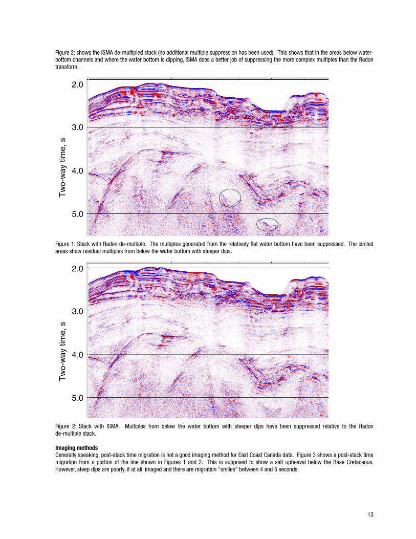
Figure 1 shows a stack of the line, with a Radon de-multiple applied,specifically directed towards removing the water-bottom multiple. Whilethis technique works well where the water bottom is regular, it is lesssuccessful below where the water bottom contains changes in dip.
Inverse Scattering Multiple Attenuation (ISMA) was applied to the line by first summing adjacent receivers, so the receiver and shot spacingwere the same. Next, the data were extrapolated to zero offset using a Hyperbolic Radon Transform applied in the CMP domain. The datawere then sorted back to shot domain for ISMA to be applied. After estimation and removal of the source signature, a residual matchingprocess was carried out. This is the most problematic and subjective part of the process. Allowing too much freedom to match the multiplemodel with the input data results in primaries being removed. Too little freedom, and artefacts can be introduced by the multiple model.
Source spacing: 25 mReceiver spacing: 12.5 mSource to near trace distance: 196 mNumber of receivers: 576CMP spacing: 6.25 mCMP fold: 144
Table 1: 2D line acquisition parameters
13
Figure 2: shows the ISMA de-multipled stack (no additional multiple suppression has been used). This shows that in the areas below water-bottom channels and where the water bottom is dipping, ISMA does a better job of suppressing the more complex multiples than the Radontransform.
2.0
3.0
4.0
5.0
Tw
o-w
ay ti
me,
s
Figure 1: Stack with Radon de-multiple. The multiples generated from the relatively flat water bottom have been suppressed. The circledareas show residual multiples from below the water bottom with steeper dips.
2.0
3.0
4.0
5.0
Tw
o-w
ay ti
me,
s
Figure 2: Stack with ISMA. Multiples from below the water bottom with steeper dips have been suppressed relative to the Radonde-multiple stack.
Imaging methodsGenerally speaking, post-stack time migration is not a good imaging method for East Coast Canada data. Figure 3 shows a post-stack timemigration from a portion of the line shown in Figures 1 and 2. This is supposed to show a salt upheaval below the Base Cretaceous.However, steep dips are poorly, if at all, imaged and there are migration "smiles" between 4 and 5 seconds.

14
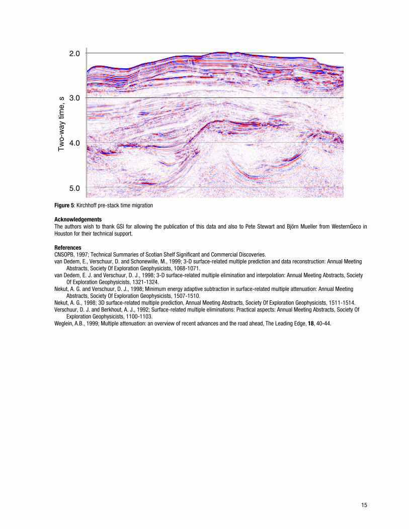
Pre-stack time migration (PreSTM) was performed on the line using two different methods. First, Common Offset Time Migration (COTiM)was performed using all 144 offsets. This form of PreSTM has been widely used in the industry (i.e. MOVES from Veritas DGC, as well asCOTiM from WesternGeco). The final COTiM migration is shown in Figure 4 and shows a generally "cleaner" image compared with the post-stack time migration, with less evidence of migration "smiles".
Kirchhoff migration was used for the second PreSTM method, the results of which are shown in Figure 5. Comparing Figures 4 and 5, it isclear that the Kirchhoff migration has imaged the steep dips significantly better than COTiM. There are still some conflicting dips in theimage (on the left flank of the salt upheaval), but these are likely to be out-of-plane (3D) effects.
Kirchhoff migration uses a double square root (DSR), which is a description of the offset term, in the design of the migration operator.Although the migration part of COTiM is zero offset (single square root), the combination of NMO, DMO and zero-offset migration isattempting to mimic the DSR. In general, Kirchhoff is a more expensive method of PreSTM compared with the COTiM approach, but withincreasing computer power, more efficient algorithms and a better looking final image, it is becoming an increasingly attractive option.
2.0
3.0
5.0
4.0
Tw
o-w
ay ti
me,
s
Figure 3: Post-stack time migration
2.0
3.0
5.0
4.0
Tw
o-w
ay ti
me,
s
Figure 4: COTiM pre-stack time migration (144 offset slots)
15
2.0
3.0
5.0
4.0
Tw
o-w
ay ti
me,
s
Figure 5: Kirchhoff pre-stack time migration
AcknowledgementsThe authors wish to thank GSI for allowing the publication of this data and also to Pete Stewart and Björn Mueller from WesternGeco inHouston for their technical support.
ReferencesCNSOPB, 1997; Technical Summaries of Scotian Shelf Significant and Commercial Discoveries.van Dedem, E., Verschuur, D. and Schonewille, M., 1999; 3-D surface-related multiple prediction and data reconstruction: Annual Meeting
Abstracts, Society Of Exploration Geophysicists, 1068-1071.van Dedem, E. J. and Verschuur, D. J., 1998; 3-D surface-related multiple elimination and interpolation: Annual Meeting Abstracts, Society
Of Exploration Geophysicists, 1321-1324.Nekut, A. G. and Verschuur, D. J., 1998; Minimum energy adaptive subtraction in surface-related multiple attenuation: Annual Meeting
Abstracts, Society Of Exploration Geophysicists, 1507-1510.Nekut, A. G., 1998; 3D surface-related multiple prediction, Annual Meeting Abstracts, Society Of Exploration Geophysicists, 1511-1514.Verschuur, D. J. and Berkhout, A. J., 1992; Surface-related multiple eliminations: Practical aspects: Annual Meeting Abstracts, Society Of
Exploration Geophysicists, 1100-1103.Weglein, A.B., 1999; Multiple attenuation: an overview of recent advances and the road ahead, The Leading Edge, 18, 40-44.