ogata village geoguide...oga peninsula-ogata geopark was certified in september 2011. it is the...
TRANSCRIPT
Ogata VillageGeoguide
Ogata Village, Akita Prefecture

Features of Ogata Village as a Geopark:
On Newborn Land - The Story of the Only Village to be Created on Reclaimed Land in Japan
Lake Hachirogata was created in the shallow waters between Oga Island and mainland Honshu by a sandbar that sheltered it from the open sea. Ogata Village was born from land reclaimed from bed of the lake. From the start, Ogata Village was to become a model Japanese village practicing modern mechanized rice farming. Settlers from all over the country were selected to farm this newborn land.The Japanese government oversaw the creation of Ogata Village and construction of its living and agricultural infrastructure. Ogata Village is the only example of a municipal construction project overseen by the Japanese government since the 1960’s. The reclaimed land of Ogata Village is characterized by expansive rice fields and long, straight roads bordered by windbreak forests. The scenery here is quite unique.Fifty years have passed since the land was reclaimed, and with it a new ecosystem called “Wetland Satoyama” was formed. Birds of prey such as the Eastern marsh harrier sit at the top of the food chain.The scenery, monuments and facilities of Ogata Village tell us about this newly born ecosystem and the history of the reclamation. We can also learn about the measures taken by villagers to maintain their way of life on this manmade land.
Before reclamation After reclamation Unosaki Coast (Oga City)
Nishikurosawa Coast (Oga City)
Sakura and Nanohana Road
Rice fields in early summer
123
What is a Geopark?A geopark is a designated site of geological, environmental and cultural or human importance that provides a rich educational experience for its visitors.
Global and Japanese GeoparksGlobal Geoparks are certified by the Global Geoparks Network, which was established with UNESCO support in 2004. A hundred areas in thirty countries, mostly in Europe and China have been certified to date. As of October 2015, there are 39 areas certified by the Japan Geopark Committee of which 8 are also certified as Global Geoparks.
Notable Features of Oga Peninsula -Ogata GeoparkOga Peninsula-Ogata Geopark was certified in September 2011. It is the first Japanese Geopark in Tohoku region. The Oga Peninsula and Ogata area is located on the 40th parallel north and has three special features.
It has 70 million years of geological history that tells the complete story from when Japan was part of the mainland continent to the present day.
The last 10,000 years of this 70 million year history saw the formation of Lake Hachirogata. The lake was then reclaimed for large-scale mechanized agriculture.
The area has been repeatedly affected by natural disasters. Memorials dedicated to earthquake and tsunami victims act as a reminder of this.
As described above, the Oga Peninsula and Ogata area is a place where we can feel the deep relationship and impact between geological, environmental and human resources. Therefore, the theme of this geopark is the place where “The Story of the Land”, “The Story of Man and the Land” and “The Bountiful Land” come together.
2 3

Latitude40°North
Longitude140°East
Tidal Gate
FunakoshiWaterway
Hachirogata Residual Lake
Ogata FujiLake Hachirogata Water-level Commemorative Monument
Latitude and LongitudeIntersection Monument
Hachirogata Reclamation MonumentWatermark monument
Central
Drainage
Channel
West
Drain
age C
hann
elEast Drainage Channel
Polder Museum ofOgata-mura
To Akita City
To Noshiro City
Ogata Village
Oga City
101
7
1 2
57
4Miyuki Bridge
Ogata Bridge
42
298
Main Drainage Channel
Katagami City
Ogata Grassland Wildlife Conservation Area and Observation Station
South Pumping Station
North Pumping Station
HachirogataTown Gojome
Town
MitaneTown
IkawaTown
JR O
u Line
Akita H
igh Way
JR Oga Line
Guide Map
Geosite
❶Polder Museum of Ogata-mura (p.6-7)
❷Hachirogata Reclamation Monument Watermark Monument (p.10)
500m from the Polder Museum❸Polder Infrastructure (p.13)
◦Drainage Channels◦Polder Dike (around village)◦Tidal Gate 12.7kms from the Polder Museum◦South Pumping Station 8.5kms from the Polder Museum◦Agricultural Water Intakes (19 in total)
❻Windbreak Forest (p.15)
❼Ogata Grasslands Wildlife Conservation Area
Observation Station (p.15)
2.4kms from the Polder Museum
❹Ogata FujiLake Hachirogata Water-level Commemorative Monument (p.14)
8.4kms from the Polder Museum
❺Latitude and Longitude Intersection Monument (p.14)
5.1kms from the Polder Museum
Signpost leading to Intersection Monument
Signpost leading to Wildlife Conservation Area Observation Station
4 5
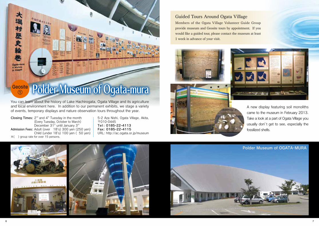
You can learn about the history of Lake Hachirogata, Ogata Village and its agriculture and local environment here. In addition to our permanent exhibits, we stage a variety of events, temporary displays and nature observation tours throughout the year.
Guided Tours Around Ogata VillageMembers of the Ogata Village Volunteer Guide Group provide museum and Geosite tours by appointment. If you would like a guided tour, please contact the museum at least 1 week in advance of your visit.
A new display featuring soil monoliths
came to the museum in February 2013.
Take a look at a part of Ogata Village you
usually don’t get to see, especially the
fossilized shells.
Closing Times: 2nd and 4th Tuesday in the month (Every Tuesday, October to March) December 31st until January 3rd
Admission Fees: Adult (over 18’s) 300 yen (250 yen) Child (under 18’s) 100 yen ( 50 yen)※( ) group rate for over 15 persons.
5-2 Aza Nishi, Ogata Village, Akita, 〒010-0445Tel : 0185-22-4113Fax: 0185-22-4115URL: http://ac.ogata.or.jp/museum
Polder Museum of Ogata-muraGeosite①
Polder Museum of OGATA-MURA
6 7

Ⅵ.干拓前(シジミガイ湖期)Ⅴ.2,000年前頃(シジミガイ湖期の初期)
Ⅲ.6,000年前頃(ゴイサギガイ湾期)Ⅱ.8,000年前頃(マガキ湾期)Ⅰ.10,000年前頃
Ⅳ.4,000年前頃(チヨノハナガイ湾期)
Ⅵ.干拓前(シジミガイ湖期)Ⅴ.2,000年前頃(シジミガイ湖期の初期)
Ⅲ.6,000年前頃(ゴイサギガイ湾期)Ⅱ.8,000年前頃(マガキ湾期)Ⅰ.10,000年前頃
Ⅳ.4,000年前頃(チヨノハナガイ湾期)
The soil in Ogata Village contains many shellfish fossils. The variety of shellfish is due to fluctuations in water depth. It reveals that the environment of Lake Hachirogata changed considerably over millennia.
8000 years agoPacific oysters, Cockles
6000 years agoRock shells, Soft-shell clams also Kagami-gai, Chirimen-gai (species of Venus clam)
4000 years agoChiyonohana-gai (a species of Venus clam)
2000 years ago Asian clam
Lake Hachirogata, a brackish lake created by the rise and fall in sea level
due to global climate change over a 10,000 year period.
Chirimen-yukigai mainly inhabits tropical and subtropical waters. They live in the Ariake Sea and a corner of the Inland Sea of Japan, but may already be extinct from the latter. The fact that 6000 year-old Chirimen-yukigai shells have been found here suggests that Lake Hachirogata had a warm climate then. Ogata Village is the only place on the Japan Sea where Chirimen-yukigai have been found to date.
Chirimen-yukigai (Meropesta Capillacea)
Shellfish Fossils Collected in Ogata Village
Pacific oyster Soft-shell clam Rock shell
Asian clam
Shells in a rice fieldAsian clams found among the roots of a windblown tree
Shellfish Representative of Each Era
Even now, the shells of Asian clams can be seen scattered across the fields of Ogata Village. The existence of these shells proves that Lake Hachirogata was a brackish lake before reclamation. Seashells have also been found on the roadside on rare occasion. Seashells are usually found deep in the soil of Ogata Village, but these shells may have been unintentionally scooped up with lakebed sand used for road construction during the reclamation.
Ⅰ.About 10,000 years agoAverage temperatures of 10,000 years ago were lower than the present day. Sea level was also about 30 meters below current levels. During this period, Hachirogata was dry land with marshland in places.
Ⅳ.About 4,000 years ago(Chiyonohana-gai [Raetellops pulchella] and bay period)A minor fall in sea level around 4,000 years ago formed sandspits in the shallowest areas on the north of south sides. The sandspits limited water flow between the Japan Sea and the shallow inland sea.
Ⅱ.About 8,000 years ago(Pacific oyster and bay period) A period of global warming to near present conditions caused a rise in sea level. Hachirogata became a deep bay with an opening on the north side.
Ⅴ.About 2,000 years ago(Early corbicula and lake period)By 2000 years ago, the continued growth of the sandspits had narrowed down the t idal inlets on the north and south sides. Hachirogata saw a decrease in salinity levels.
Ⅲ.About 6,000 years ago (Goisagi-gai [Macoma tokyoensis] and bay period)The climate was warmest about 6000 years ago. Sea levels were 2 to 3 meters higher than the present day. As a result, the southern area of land was also submerged and Hachirogata became a shallow inland sea between Oga and the mainland.
Ⅵ.Before reclamation(Corbicula and lake period)The northern tidal inlet was eventually blocked by sand. The only connection with the Japan Sea was by a narrow wate rway on the south side. The creation of Lake Hachirogata was almost complete.
→
→
→
→
The History of Lake Hachirogata
*The years indicated above are approximate.* A sandspit is a landform created by sand deposits from water currents.
8 9
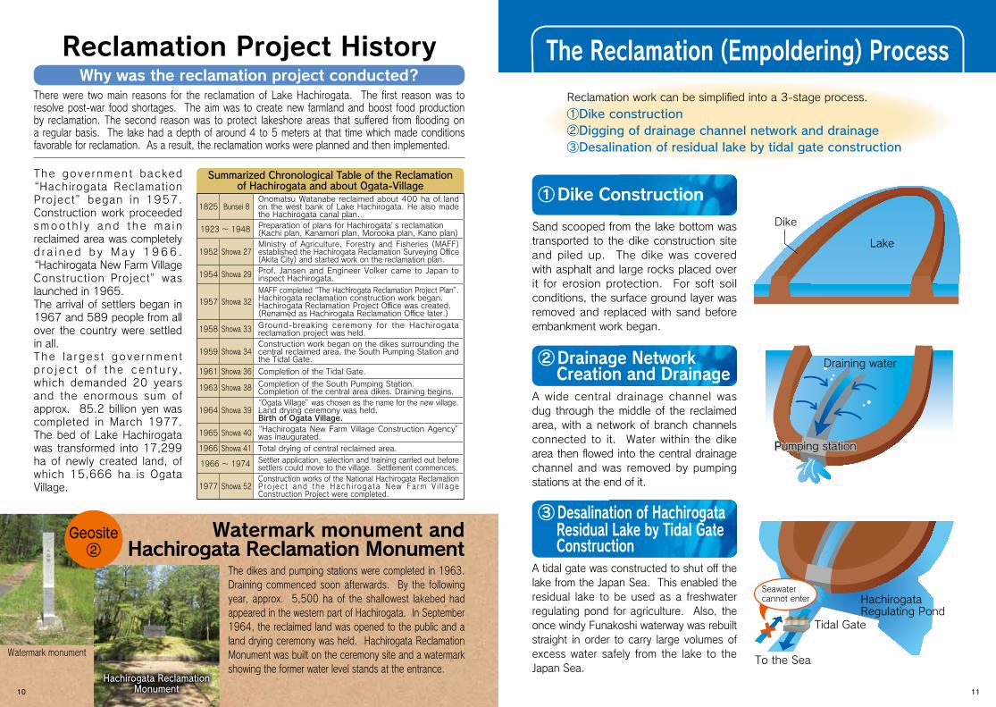
The dikes and pumping stations were completed in 1963. Draining commenced soon afterwards. By the following year, approx. 5,500 ha of the shallowest lakebed had appeared in the western part of Hachirogata. In September 1964, the reclaimed land was opened to the public and a land drying ceremony was held. Hachirogata Reclamation Monument was built on the ceremony site and a watermark showing the former water level stands at the entrance.
Watermark monument and Hachirogata Reclamation Monument
Reclamation Project History The Reclamation (Empoldering) ProcessThere were two main reasons for the reclamation of Lake Hachirogata. The first reason was to resolve post-war food shortages. The aim was to create new farmland and boost food production by reclamation. The second reason was to protect lakeshore areas that suffered from flooding on a regular basis. The lake had a depth of around 4 to 5 meters at that time which made conditions favorable for reclamation. As a result, the reclamation works were planned and then implemented.
Summarized Chronological Table of the Reclamationof Hachirogata and about Ogata-Village
Tidal Gate
To the Sea
Seawater cannot enter
Dike
Draining water
HachirogataRegulating Pond
Pumping stationPumping station
Lake
Why was the reclamation project conducted?
①Dike Construction
Sand scooped from the lake bottom was transported to the dike construction site and piled up. The dike was covered with asphalt and large rocks placed over it for erosion protection. For soft soil conditions, the surface ground layer was removed and replaced with sand before embankment work began.
②Drainage Network Creation and Drainage
A wide central drainage channel was dug through the middle of the reclaimed area, with a network of branch channels connected to it. Water within the dike area then flowed into the central drainage channel and was removed by pumping stations at the end of it.
③ Desalination of Hachirogata Residual Lake by Tidal Gate Construction
A tidal gate was constructed to shut off the lake from the Japan Sea. This enabled the residual lake to be used as a freshwater regulating pond for agriculture. Also, the once windy Funakoshi waterway was rebuilt straight in order to carry large volumes of excess water safely from the lake to the Japan Sea.
Reclamation work can be simplified into a 3-stage process.
①Dike construction②Digging of drainage channel network and drainage③Desalination of residual lake by tidal gate construction
Watermark monument
Hachirogata Reclamation Monument
The gove rnment backed “Hachirogata Reclamation Project” began in 1957. Construction work proceeded smoo t h l y a nd t h e ma i n reclaimed area was completely d r a i n e d b y M a y 1 9 6 6 .
“Hachirogata New Farm Village Construction Project” was launched in 1965. The arrival of settlers began in 1967 and 589 people from all over the country were settled in all.The l a rges t gove rnmen t p r o j e c t o f t h e c en t u r y, which demanded 20 years and the enormous sum of approx. 85.2 billion yen was completed in March 1977. The bed of Lake Hachirogata was transformed into 17,299 ha of newly created land, of which 15,666 ha is Ogata Village.
1825 Bunsei 8Onomatsu Watanabe reclaimed about 400 ha of land on the west bank of Lake Hachirogata. He also made the Hachirogata canal plan.
1923 〜 1948 Preparation of plans for Hachirogata’s reclamation(Kachi plan, Kanamori plan, Morooka plan, Kano plan)
1952 Showa 27Ministry of Agriculture, Forestry and Fisheries (MAFF) established the Hachirogata Reclamation Surveying Office (Akita City) and started work on the reclamation plan.
1954 Showa 29 Prof. Jansen and Engineer Volker came to Japan to inspect Hachirogata.
1957 Showa 32MAFF completed “The Hachirogata Reclamation Project Plan”.Hachirogata reclamation construction work began.Hachirogata Reclamation Project Office was created. (Renamed as Hachirogata Reclamation Office later.)
1958 Showa 33 Ground-breaking ceremony for the Hachirogata reclamation project was held.
1959 Showa 34Construction work began on the dikes surrounding the central reclaimed area, the South Pumping Station and the Tidal Gate.
1961 Showa 36 Completion of the Tidal Gate.
1963 Showa 38 Completion of the South Pumping Station.Completion of the central area dikes. Draining begins.
1964 Showa 39“Ogata Village” was chosen as the name for the new village.Land drying ceremony was held.Birth of Ogata Village.
1965 Showa 40 “Hachirogata New Farm Village Construction Agency” was inaugurated.
1966 Showa 41 Total drying of central reclaimed area.
1966 〜 1974 Settler application, selection and training carried out before settlers could move to the village. Settlement commences.
1977 Showa 52Construction works of the National Hachirogata Reclamation P ro jec t and the Hach i roga ta New Fa rm V i l l age Construction Project were completed.
Geosite②
10 11
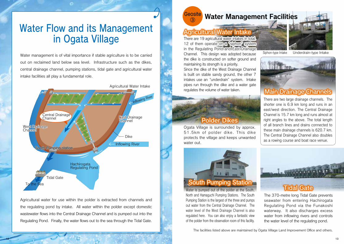
The facilities listed above are maintained by Ogata Village Land Improvement Office and others.
There are 19 agricultural water intakes in total. 12 of them operate on a “siphon” system in the Regulating Pond and East Drainage Channel. This design was adopted because the dike is constructed on softer ground and maintaining its strength is a priority.Since the dike of the West Drainage Channel is built on stable sandy ground, the other 7 intakes use an “underdrain” system. Intake pipes run through the dike and a water gate regulates the volume of water taken.
Water management is of vital importance if stable agriculture is to be carried
out on reclaimed land below sea level. Infrastructure such as the dikes,
central drainage channel, pumping stations, tidal gate and agricultural water
intake facilities all play a fundamental role.
Agricultural water for use within the polder is extracted from channels and
the regulating pond by intake. All water within the polder except domestic
wastewater flows into the Central Drainage Channel and is pumped out into the
Regulating Pond. Finally, the water flows out to the sea through the Tidal Gate.
To the Sea
Central Drainage Channel
Hachirogata Regulating Pond
Tidal Gate
Dike
Agricultural Water Intake
Inflowing River
South Pumping stationSouth Pumping stationInflowing River
West DrainageChannelWest DrainageChannel
East Drainage ChannelEast Drainage Channel
Ogata Village is surrounded by approx. 51.5km of polder dike. This dike protects the village and keeps unwanted water out.
Water is pumped out of the polder at the South, North and Hamaguchi Pumping Stations. The South Pumping Station is the largest of the three and pumps out water from the Central Drainage Channel. The water level of the West Drainage Channel is also regulated here. You can also enjoy a fantastic view of the polder from the observation room of this facility.
The 370-metre long Tidal Gate prevents seawater from entering Hachirogata Regulating Pond via the Funakoshi waterway. It also discharges excess water from inflowing rivers and controls the water level of the regulating pond.
Water Management Facilities
Agricultural Water Intake
Main Drainage Channels
Tidal Gate
Polder Dikes
South Pumping Station
There are two large drainage channels. The shorter one is 6.9 km long and runs in an east/west direction. The Central Drainage Channel is 15.7 km long and runs almost at right angles to the above. The total length of all branch lines and drains connected to these main drainage channels is 620.7 km. The Central Drainage Channel also doubles as a rowing course and boat race venue.
Water Flow and its Management in Ogata Village
Siphon-type Intake Underdrain-type Intake
Geosite③
12 13
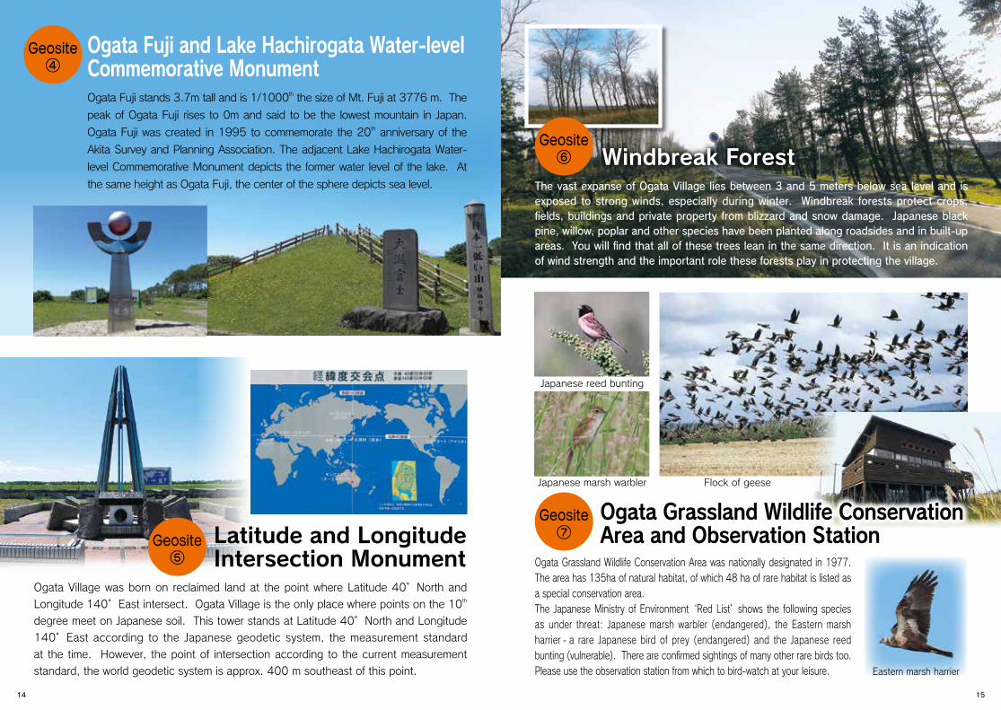
Ogata Fuji stands 3.7m tall and is 1/1000th the size of Mt. Fuji at 3776 m. The
peak of Ogata Fuji rises to 0m and said to be the lowest mountain in Japan.
Ogata Fuji was created in 1995 to commemorate the 20th anniversary of the
Akita Survey and Planning Association. The adjacent Lake Hachirogata Water-
level Commemorative Monument depicts the former water level of the lake. At
the same height as Ogata Fuji, the center of the sphere depicts sea level. The vast expanse of Ogata Village lies between 3 and 5 meters below sea level and is exposed to strong winds, especially during winter. Windbreak forests protect crops, fields, buildings and private property from blizzard and snow damage. Japanese black pine, willow, poplar and other species have been planted along roadsides and in built-up areas. You will find that all of these trees lean in the same direction. It is an indication of wind strength and the important role these forests play in protecting the village.
Ogata Grassland Wildlife Conservation Area was nationally designated in 1977. The area has 135ha of natural habitat, of which 48 ha of rare habitat is listed as a special conservation area.The Japanese Ministry of Environment ‘Red List’ shows the following species as under threat: Japanese marsh warbler (endangered), the Eastern marsh harrier - a rare Japanese bird of prey (endangered) and the Japanese reed bunting (vulnerable). There are confirmed sightings of many other rare birds too. Please use the observation station from which to bird-watch at your leisure.
Windbreak Forest
Ogata Grassland Wildlife Conservation Area and Observation Station
Ogata Fuji and Lake Hachirogata Water-level Commemorative Monument
Japanese reed bunting
Japanese marsh warbler Flock of geese
Eastern marsh harrier
Geosite④
Ogata Village was born on reclaimed land at the point where Latitude 40°North and
Longitude 140°East intersect. Ogata Village is the only place where points on the 10th
degree meet on Japanese soil. This tower stands at Latitude 40°North and Longitude
140°East according to the Japanese geodetic system, the measurement standard
at the time. However, the point of intersection according to the current measurement
standard, the world geodetic system is approx. 400 m southeast of this point.
Latitude and LongitudeIntersection Monument
Geosite⑤
Geosite⑥
Geosite⑦
14 15

For further information please contact ▼ Polder Museum of Ogata-mura
Ogata Village, Akita Prefecture
Access InformationBy Train
◦Tokyo to Akita (approx. 3hrs 45min) ◦JR Ou Line Akita to Hachirogata (approx. 23min)
◦Haneda Airport (Tokyo) to Akita (65min)
By Plane ◦Chubu Airport (Nagoya) to Akita (85min)
◦Osaka International Airport (Osaka) to Akita (85min) ◦Shin-Chitose (Sapporo) Airport to Akita (55min)
◦90 min from Akita Airport ◦60 min from JR Akita stationBy Car ◦20 min from JR Hachirogata station ◦20 min from JR Kado station
◦20 min from JR Funakoshi station
Futatsui-Shirakami I.CFutatsui-Shirakami I.CFutatsui-Shirakami I.C
能代
大曲
大館
Higashi Noshiro
AkitaJapan Sea
Oga Futada
Hachirogata
Moritake
大館能代空港
Akita Airport
Oga Line
Akita Shinkansen Line
Ou
Line
Ogata Village Kotooka-Moritake I.C
Gojome-Hachirogata I.C
Hachiryu I.C
Showa-Ogahanto I.C
Akita-kita I.C
Akita-minami I.C
Akita-chuo I.C
101 7
7
Akita Airport I.C Kawabe JCT
5-2 Aza Nishi, Ogata Village, Akita, 〒010-0445
TEL:0185-22-4113 FAX:0185-22-4115E-mail [email protected] URL http://ac.ogata.or.jp/museum/
Produced by the Polder Museum of Ogata-mura
16