okeanos explorer - uaf home · okeanos explorer fy12 data management plan table of contents i....
TRANSCRIPT

1 10 April 2012 DRAFT EX_FY12_DMP_Draft.pdf
Okeanos Explorer
FY12 Data Management Plan
Table of Contents I. Document Purpose ............................................................................................................................ 2 II. Document Authority ......................................................................................................................... 2 III. Scope of Plan ................................................................................................................................. 2 IV. Data Management Plan Overview ................................................................................................. 2 V. EX Instrument and Data Type Inventory .......................................................................................... 3 VI. Data Flow Strategies and Procedures ............................................................................................ 5
A. Standard Operating Procedures (SOP) ....................................................................................... 5 B. Synchronization Procedures from Shipboard Repository Server (SBRS) to Shoreside Redistribution Server (SRS) ................................................................................................................. 6 C. Shoreside Redistribution Server (SRS) Folder Structure and File Naming Conventions and Standards ............................................................................................................................................... 7
VII. Data and Product Pipelines ............................................................................................................ 9 A. Oceanographic/Meteorological/Navigational Data Archive Pipeline ........................................ 9 B. Multibeam Survey Data Archive Pipeline ............................................................................... 12 C. Video Data Archive Pipeline ................................................................................................... 16 D. Geospatial Data and Products Pipeline .................................................................................... 18
VIII. Data Exchange Agreements and Archive Strategies................................................................ 19 IX. Underwater Cultural Heritage (UCH) Data Responsibilities ...................................................... 22 X. EX Iconographic Products .............................................................................................................. 23 XI. Data Discovery and Access ......................................................................................................... 25
A. Geographic Information Systems (GIS) .................................................................................. 25 B. Education Expedition Modules and Lesson Plans ................................................................... 26
XII. Data Management Points of Contact ........................................................................................... 27

Okeanos Explorer Data Management Plan: FY12
2 10 April 2012 DRAFT EX_FY12_DMP_Draft.pdf
I. Document Purpose This document outlines a plan for managing data and information recorded, collected, or otherwise generated by the NOAA Ship Okeanos Explorer (EX) during its missions in Fiscal Year 2012. This plan is intended to support a comprehensive and standardized approach to identifying, acquiring, displaying, archiving, and publishing EX mission data and information.
Date Author Version Comments 2/14/2012 S. Gottfried 1.0 Initial Draft 3/23/2012 S. Gottfried 1.1 Updated Video Pipeline
II. Document Authority NOAA environmental and geospatial data are maintained in accordance with applicable Office of Management and Budget (OMB) regulations, including OMB Circulars A-16 and A-130; Federal Geographic Data Committee (FGDC) approved data standards; the Geospatial Profile of the Federal Enterprise Architecture; federal law related to records management within federal agencies – Sections 3101-3107 of Title 44 of the United States Code (44 U.S.C. 3101-3107); the Paperwork Reduction Act of 1995 (44 U.S.C. 3501 et seq.); and the National Archives and Records Administration (NARA) Records Management Regulations – Parts 1220-1238 of Title 36 of the Code of Federal Regulations (36 CFR 1220-1238); NOAA Administrative Issuance NAO 205-17 and NAO 212-15; and the Federal Rules of Civil Procedure (28 U.S.C. § 2072). NOAA Information Access and Dissemination establishes policy for distributing scientific and technical publications and ensuring compliance with NOAA’s mission to provide environmental information to its user communities. NOAA Management of Environmental and Geospatial Data and Information provides high-level direction that guides procedures, decisions, and actions regarding environmental data and information management throughout NOAA.
III. Scope of Plan This plan sets forth a comprehensive and standardized approach to identifying, acquiring, displaying, archiving, and publishing EX data. The scope of this plan addresses EX data in its current state and custody arrangement and provides for management throughout the remainder of its lifecycle. It is designed to work in part or in whole to accomplish NOAA’s primary data management objectives and may be executed for one data type or the entire universe of EX data and information.
IV. Data Management Plan Overview The data collected and/or recorded and products generated as a result of a mission on the EX will be managed by an Integrated Product Team (IPT) charged with managing data and products for NOAA’s Office of Ocean Exploration and Research (OER). The IPT is comprised of personnel from OER, the NOAA Data Centers, and other extramural partners. Because the EX is NOAA’s first vessel dedicated solely to exploration, all data recorded, products generated, and discoveries made during a mission will

Okeanos Explorer Data Management Plan: FY12
3 10 April 2012 DRAFT EX_FY12_DMP_Draft.pdf
be made discoverable and accessible to the general public in as close to real-time as possible. Exceptions to this will be noted in the individual mission Data Management Plans (DMP) when data are protected due to submerged cultural resources, in foreign waters, or other valid reason. Public access of these data will be achieved through a variety of discovery and access points, including secure FTP servers, account controlled content management sites, metadata search engines, public access websites, and customized geospatial applications.
V. EX Instrument and Data Type Inventory Meteorological/Oceanographic/Navigational (MET/OCN/NAV): The EX is equipped with an integrated suite of oceanographic/navigational/meteorological instrumentation which is monitored by the Scientific Computing System (SCS) maintained by NOAA’s Office of Marine and Aviation Operations (OMAO). The EX also has an over-the-side deployable CTD / Rosette instrument for collecting water column profile data and water samples; and maintains an inventory of eXpendable BathyThermographs (XBTs) for collecting water column temperature and depth. The EX also has an EK60 single beam sonar system for detecting features in the water column. These data are typically archived at NOAA’s National Oceanographic Data Center (NODC) in Silver Spring, MD. Bathymetry and Water Column Backscatter (GEO): The EX has a state-of-the-art multibeam sonar system, the Kongsberg EM302, complementary bottom-looking sensors, and calibrating instrumentation. These data and the products that result are typically archived at NOAA’s National Geophysical Data Center (NGDC) in Boulder, CO. Multimedia (MUL): The EX has two dedicated submersibles for the FY12 field season. The Little Hercules ROV and a custom designed camera sled, named “Seirios”. These vehicles will be operated collaboratively for deep water exploration captured on video. Each vehicle will record high-definition video and Conductivity, Temperature, Depth (CTD) data while underway. As part of the standard post-processing procedures, high-resolution still imagery will be created from the recorded video. These data are typically archived at the NOAA Central Library (NCL) in Silver Spring, MD. A complete list of EX data and products which must be managed is found in Table 1 below.

Okeanos Explorer Data Management Plan: FY12
4 10 April 2012 DRAFT EX_FY12_DMP_Draft.pdf
Data Class
Instrument Data Type Data Format
GEO Kongsberg EM302 (30 kHz)
Multibeam Bathymetry, Bottom Backscatter, Water Column Backscatter
(proprietary format read into MBSystem)
.all, .wcd (proprietary), .txt (ASCII full resolution XYZ bathymetry), .sd
(Fledermaus object), .tif (gridded bathymetry, GeoTIF image), .kml
(map overlay) GEO Simrad EK60 Water Column Backscatter .raw, .bot, .idx GEO Kongsberg EA600
(12 kHz) Singlebeam (removed for FY12) .txt, .xyz (ASCII), .dg, .out, .raw
(proprietary) GEO Knudsen CHIRP
3260 (3.5 kHz) Sub-bottom profile .sgy, .kea, .keb (proprietary).
MET RM Young 61202V Barometric Pressure (mB) .raw (ASCII) MET RM Young
41382VC Air Temperature (deg C) .raw (ASCII)
MET RM Young 41003P Relative Humidity (Pct) .raw (ASCII) MET RM Young
05106/RM Young 05306B
Relative Wind Speed (knots)/Relative Wind Direction (degrees)
.raw (ASCII)
MET Derived True Wind Speed/Direction .raw (ASCII) MET Epply PSP and PIR Solar Radiation (kWh/m2) .raw (ASCII) NAV Applanix POS/MV
320 Location, Heading, Attitude (Decimal
degrees, degrees, degrees) .raw (ASCII)
NAV CNAV DGPS/C-NAV 2000
Global Position (Decimal degrees) .raw (ASCII)
NAV Gyro Compass Compass Readings .raw (ASCII) OCN SeaBird SBE-
911plus Conductivity, Temperature, Depth, Light Scattering Sensor, Oxidation-
Reduction Potential, Dissoved Oxygen, Altimeter
.hex, .con (Proprietary); .cnv, .hdr, .bl, .jpg (processed)
OCN SeaBird SBE-45 FastCat Micro
Temperature, Salinity, Sound Velocity (deg C, psu, m/s)
OCN Sippican MK-21 eXpendable
BathyThermograph (XBT)
Temperature, Depth, Sound Velocity (deg C, meters, m/s)
.edf (ASCII)
OCN RESON SVP 70 Sound Velocity Profile .raw (ASCII) MUL Insite Pacific Inc.,
Cyclops Super Wide Angle Color Camera
(camera sled)
Black & White Video Clips, Framegrabs h.264 high-definition & h.264 low-resolution
MUL Insite Pacific Inc., Zeus Plus High-
Definition 3-CCD Color Zoom Camera
(ROV & camera
Color Video Clips, Framegrabs h.264 high-definition & h.264 low-resolution

Okeanos Explorer Data Management Plan: FY12
5 10 April 2012 DRAFT EX_FY12_DMP_Draft.pdf
sled) MUL Insite Pacific Inc.,
Mini Zeus High-Definition Color Zoom Camera (camera sled)
Color Video Clips, Framegrabs h.264 high-definition & h.264 low-resolution
Table 1: EX Instrument/Data Type Inventory
VI. Data Flow Strategies and Procedures Data recorded and/or products generated as a result of an EX mission will be managed first by the strict enforcement of Standard Operating Procedures (SOPs) followed by specified crew members, mission specific onboard personnel and by a team of data managers ashore. SOPs for data and metadata flow through to the archives and to data discovery and accessibility tools will be followed by the EX data management team and assigned mission data managers. To facilitate data pipelines from ship-to-shore, OER manages a Shoreside Redistribution Server (SRS) at the University of Rhode Island, Graduate School of Oceanography (URI/GSO). The SRS is comprised of several services including: a secure FTP server, a web-portal for managing operations (the Okeanos Explorer Portal), and an Instant Messaging server (iChat). This SRS was used with success in the FY11 EX field season and will be employed again for the FY12 EX field season. This SRS will be the conduit for most of the movement of data from the ship through the data pipelines. Hard-drive transfers will be employed where transmission of data through the SRS and/or the ships VSAT is not feasible. SOPs for mission-critical communication strategies and transmission of data to the SRS are documented in a series of SOPs for the mission.
A. Standard Operating Procedures (SOP) The following SOP documents are considered important in the data management effort and are maintained onboard the EX for reference.
• Okeanos Explorer Portal: SOP for Conducting Standard Tasks for Expedition Coordinators • Okeanos Explorer Portal: SOP for Conducting Standard Tasks for Mission Participants • Using the EX Online Image Gallery (Jan 2011) • iChat Server Protocols • Okeanos Atlas: SOP for Updating in Near Real-Time and Post-Mission • Standard Operating Procedures for Mapping Operations Involving Underwater Cultural
Resources (DRAFT)

Okeanos Explorer Data Management Plan: FY12
6 10 April 2012 DRAFT EX_FY12_DMP_Draft.pdf
B. Synchronization Procedures from Shipboard Repository Server (SBRS) to Shoreside Redistribution Server (SRS)
In FY12, a new synchronization procedure will be attempted to place the files that are to be managed for the mission into five tiers. The synchronization process aims to optimize the use of the ship’s bandwidth to automate scripts that run hourly to insure that the most important files have the highest priority of being transmitted to the SRS and extra time and, during off hours, extra bandwidth will provide the capability to get all data files successfully transmitted from the SBRS to the SRS during the mission.

Okeanos Explorer Data Management Plan: FY12
7 10 April 2012 DRAFT EX_FY12_DMP_Draft.pdf
C. Shoreside Redistribution Server (SRS) Folder Structure and File Naming Conventions and Standards
[ ] = optional input; { } = choice input; yyyymmddThh[mmss]Z = ISO8601 Standard for Time
OkeanosCruises • EXyynn[L#] (ex. EX1103L2) • CTD
o asvp = EXyynn[L#]_CTDnn_yyyymmddThh[mmss]Z.asvp = EXyynn[L#]_DIVEnn_yyyymmddThh[mmss].asvp = EXyynn[L#]_XBTnn_yyyymmddThh[mmss].asvp
o ROV = EXyynn[L#]_DIVEnn_ROVCTD_yyyymmddThh[mmss]Z o Seirios = EXyynn[L#]_DIVEnn_CPCTD_yyyymmddThh[mmss]Z.{con,hdr,hex,bl,jpg} o SHIP = EXyynn[L#]_CTDnn_yyyymmddThh[mmss]Z.{con,hdr,hex,bl,jpg} o XBT = EXyynn[L#]_XBTnn_yyyymmddThh[mmss]Z.{edf,rdf}
• EK60 = EXyynn[L#]_EK60_yyyymmddThh[mmss]Z.{bot,idx,raw} • EventLogs = EXyynn[L#]_EVT_yyyymmddThh[mmss]Z • Imagery
o EXyynn[L#]_DIVEnn_yyyymmdd = EXyynn[L#]_IMG_yyyymmddThh[mmss]Z_{camera}_short_desc.{tif,jpg}
o TOPSIDE = EXyynn[L#]_IMG_yyyymmddThh[mmss]Z_{camera}_short_desc.{tif,jpg}
• Multibeam o EXyynn[L#]_MB_DLY_yyyymmdd
= EXyynn[L#]_MB_DLY_res_proj_yyyymmdd.{all,wcd,kmz,tif,txt,xyz,asc,sd} • Products
o CTD_Methane_Analysis = EXyynn[L#]_CTDnn_yyyymmdd.xls
o CTD_Rosette_Summaries = EXyynn[L#]_CTDnn_yyyymmdd.{doc,pdf,xls}
o Expedition_Overview_Maps = EXyynn[L#]_yyyymmdd.pdf
o PODs = EXyynn[L#]_POD_yyyymmdd.doc
o ROV DIVE_SUMMARIES = EXyynn[L#]_DIVEnn_SUMMARY_yyyymmdd_FINAL.doc DIVE_TRAILERS = EXyynn[L#]_DIVEnn_TRAILER_yyyymmdd_res.mov EXyynn[L#]_DIVEnn_yyyymmdd = EXyynn[L#]_DIVEnn_{DepthAlt,DiveTrack,EndPoints,Events,etc}.{png,kml,doc,csv} ROV_Dive_Maps = EXyynn[L#]_DIVEnn_MAP_yyyymmdd.{jpg} ROV_Dive_MB_Images = EXyynn[L#]_DIVEnn_MB_yyyymmdd.{jpg}
o SITREPs = EXyynn[L#]_SITREP_yyyymmdd_FINAL.doc
o HighlightImages = EXyynn[L#]_IMG_yyyymmddThhmmssZ_camera.{tif,jpg} = EXyynn[L#]_Image_Captions.txt

Okeanos Explorer Data Management Plan: FY12
8 10 April 2012 DRAFT EX_FY12_DMP_Draft.pdf
o HighlightVideos = EXyynn[L#]_VID_yyyymmddThhmmssZ_camera_res = EXyynn[L#]_Video_Captions.txt
o Tracklines = EXyynn[L#]_SHPTRK_yyyymmdd.kml = EXyynn[L#]_DIVEnn_ROVTRK_yyyymmdd.kml = EXyynn[L#]_DIVEnn_CPTRK_yyyymmdd.kml
• SCSData o EventData o MAILER (SAMOS and WebShip export files) o METOC (SCS Output .raw files)
BARO = standard SCS ASCII files (barometric pressure) DEPTH = standard SCS ASCII files (doppler depth) Flowmeter= standard SCS ASCII files (flowthrough) Fluorometer= standard SCS ASCII files (fluorometer) Wind = standard SCS ASCII files (wind and relative wind) Sound Velocity= standard SCS ASCII files (sound velocity) TSG = standard SCS ASCII files (thermosalinograph)
o NAV (Ship Navigation Sensor output .raw files) AIS = standard SCS ASCII files (marine traffic) CNAV = standard SCS ASCII files (navigation instrumentation) DGPS = standard SCS ASCII files (differential GPS) GYRO = standard SCS ASCII files (roll stabilization) POSMV = standard SCS ASCII files (vessel position and orientation)
o ROUTER (Router .raw files) o VEHICLES (Vehicle Sensor output .raw files)
CP = standard SCS ASCII files (camera platform integrated sensors) ROV = standard SCS ASCII files (ROV integrated sensors)
• Video o EXyymm[L#]_DIVEnn_yyyymmdd
= EXyynn[L#]_VID_yyyymmddThhmmssZ_camera_short_title_res

Okeanos Explorer Data Management Plan: FY12
9 10 April 2012 DRAFT EX_FY12_DMP_Draft.pdf
Camera Placement Camera Description Camera Code ROV Main HD Camera ROVHD ROV Umbilical SD Camera ROVUMBIL ROV Pilot SD Camera ROVPILOT ROV Utility SD Camera ROVUTIL Camera Platform Main HD Camera CPHD Camera Platform Umbilical SD Camera CPUMBIL Camera Platform Pilot SD Camera CPPILOT Camera Platform Spare SD Camera CPSPARE Starboard Side of Fantail HD Video Camera SBROBO Post Side of Fantail HD Video Camera PTROBO Front of ROV/Mapping Control Room
HD Video Camera CRROBO
Back of ROV/Mapping Control Room
HD Video Camera CR2ROBO
Dry Lab HD Video Camera DLROBO Portable Hand-held HD Video Camera HH Pulled from DVI-HDSDI scan
converters DVI
Bridge Mast Closed-Circuit Television Camera MASTCCTV Port Bridge Wing Closed-Circuit Television Camera PTBRDGCCTV Starboard Bridge Wing Closed-Circuit Television Camera SBBRDGCCTV Starboard Working Deck (CTD Launch)
Closed-Circuit Television Camera SBDECKCCTV
Aft Deck Closed-Circuit Television Camera AFTDECKCCTV ROV/Mapping Control Room Closed-Circuit Television Camera CRCCTV Generator Room Closed-Circuit Television Camera GENCCTV Upper Motor Room Closed-Circuit Television Camera MOTORCCTV Winch Room Looking at Traction Winch and Storage Drum
Closed-Circuit Television Camera WINCHCCTV
Composite of First 9 CCTVs 3X3CCTV Fantail Looking at Transom Closed-Circuit Television Camera WIRECCTV Winch Room Looking at Traction Winch Sheave
Closed-Circuit Television Camera SHEAVECCTV
ROV Hangar Closed-Circuit Television Camera HANGARCCTV Bow Thruster Room Closed-Circuit Television Camera BOWTHRUSTCCTV Portable Digital Still Camera DSLR Table 2: Camera Codes for Naming Conventions Camera Resolution Code Camera Resolution Code Medium-resolution high-definition quality
med
Low-resolution web-streaming quality low Table 3: Camera Resolution Codes for Naming Convention

Okeanos Explorer Data Management Plan: FY12
10 10 April 2012 DRAFT EX_FY12_DMP_Draft.pdf
VII. Data and Product Pipelines
A. Oceanographic/Meteorological/Navigational Data Archive Pipeline Data from hull-mounted and off-board oceanographic and meteorological (METOC) sensors; integrated oceanographic sensors from the submersibles; and navigational instrumentation on both the vessel and its submersibles are monitored through the ship’s Scientific Computer System (SCS). Some of these data will be used in a near real-time mode to update the Okeanos Atlas. All of these data will be archived at the National Oceanographic Data Center (NODC) Marine Data Stewardship Division (MDSD) in Silver Spring, MD. A collection level metadata record describing the data inventory to be archived at the NODC/MDSD will be included with the data submission.
Fig 1: Oceanographic/Meteorological/Navigational Data Archive Pipeline

Okeanos Explorer Data Management Plan: FY12
11 10 April 2012 DRAFT EX_FY12_DMP_Draft.pdf
At periodic (currently fifteen minutes) intervals, an email from the ship to NCDDC is delivered with the ship’s position and a snapshot of the SCS sensor suite. As CTD or XBT casts are deployed, the results of the cast are included in the hourly synchronizations to the SRS. The GIS team at NCDDC processes CTD cast data into thinned profiles for comparison to World Ocean Atlas historical profiles in the same region and month. The thinned profiles are geo-located on the Okeanos Atlas. Ship track and sensor snapshot readings are geo-located on the Okeanos Atlas.
All SCS data, including navigation and CTD/XBT cast data are saved to a hard-drive. This hard-drive is the same that will hold the multibeam survey raw data and products generated on-board. This hard-drive will be either brought back or shipped to the University of New Hampshire Center for Coastal and Ocean Mapping (UNH CCOM) for post-processing, after which it will be shipped to NCDDC.
The Data Management team will post-process the SCS, NAV, CTD, and XBT raw data files, adding ASCII headers to each file and generating NetCDF-3 formatted files for the entire cruise for both SCS/NAV data and CTD/XBT data. FGDC CSDGM metadata will be generated for the navigational data and for the METOC sensor data.
The ASCII files, and the metadata will be uploaded to the National Oceanographic Data Center (NODC), where they will be accessioned and archived.
The NetCDF3 file will be ingested into an NCDDC hosted Thematic Real-time Environmental Distributed Data Services (THREDDS) server for user discoverability and access. Data Class
Instrument Data Type Format Metadata Granularity
Archive Center
OCN/MET
All SCS monitored
sensors
Meteorological and Oceanographic data
sensors
ASCII 1 meta rec NODC/MDSD
NAV DGPS, CNAV
EX, ROV, and sled navigation
ASCII 1 meta rec NODC/MDSD
ALL All Archive Ready NetCDF-3 1 meta rec NODC/MDSD Table 4: Oceanographic/Meteorological/Navigational Metadata Granularity and Target Archive
1
2

Okeanos Explorer Data Management Plan: FY12
12 10 April 2012 DRAFT EX_FY12_DMP_Draft.pdf
B. Multibeam Survey Data Archive Pipeline The multibeam survey data collected by bottom-looking and complementary sensors, data from the calibration instruments, and the products generated after the data is returned to and post-processed at UNH will be archived at the NGDC. These data will be accompanied with a collection level metadata record for the NGDC as well as individual metadata records for each raw (level-0) file, each edited (level-1) file and each data product (level-2) and report (level-3) generated as a result. In addition, the submission to NGDC will include the following:
• raw (level-0) mapping survey and water column data files, • CTD and/or XBT profile data used for calibration in multibeam survey, • post-processed, quality assured, and edited (level-1) data files, • specific data products (level-2) including cumulative GeoTIF images, gridded bathymetric files,
KML files, Fledermaus output files, and an ArcGrid format, and • comprehensive mapping survey data summary (level-3) report.
Figure 2: Multibeam Survey Data Archive Pipeline

Okeanos Explorer Data Management Plan: FY12
13 10 April 2012 DRAFT EX_FY12_DMP_Draft.pdf
Near Real-Time The mapping survey team on the EX will include their operational processing spreadsheet in the folder that is targeted for synchronization to the SRS periodically throughout the day. As operational GeoTIFF images are created, these will also be saved to this folder. The data management team at NCDDC pulls the GeoTIFF images, operational bathymetry processing spreadsheet and the SCS data streams for near real-time metadata generation and Okeanos Atlas update procedures. Daily cumulative GeoTIFF images of the seafloor imagery are geo-located on the Okeanos Atlas by the GIS team at NCDDC. Provisional metadata in an ISO format is generated for each raw (level-0) multibeam raw files using the SCS exported data, the operational processing spreadsheet and saved to the SRS. Participating scientists wanting access to the raw multibeam in near real-time can pull the individual files with the metadata that provides operational and provisional processing steps and a disclaimer for non-QC status of the data. Post-Mission
All bottom-looking sensor data and complementary data (water column and sound velocity) are saved to a hard-drive. This hard-drive will be either brought back or shipped to the University of New Hampshire Center for Coastal and Ocean Mapping (UNH CCOM) for post-processing.
A full complement of multibeam data from a 30-day EX cruise on which the Kongsberg EM302 multibeam system runs continuously will produce 200-300 Gigabytes of raw multibeam (37.5% of total volume) and water column data (62.5% of total volume). At UNH, the mapping team will post-process the multibeam data through the following steps: • The raw (level-0) data will be saved to the CCOM file servers, where they will be quality checked
and post-processed. • The edited level-0 data is saved as level-1 data files in a non-proprietary format – ASCII xyz files
(cleaned not gridded).
1
2
3
4
5

Okeanos Explorer Data Management Plan: FY12
14 10 April 2012 DRAFT EX_FY12_DMP_Draft.pdf
• The post-processing steps used to produce the level-1 data will be documented. • Level-2 products will be generated from the level-1 data files. • The post-processing steps used to produce the level-2 data products will be documented. • The level-1 data, level-2 products, post-processing steps, and working data processing spreadsheets
will be copied to the hard drive in a new folder. A processing spreadsheet for FY12 will contain the temporal and spatial limits of each file and any supplemental information documenting problems or issues that affected the quality of the data in that file.
The hard-drive will be shipped to the NCDDC within approximately 3 weeks from cruise end date.
At NCDDC, all multibeam related files will be post-processed through metadata generation procedures. Metadata will be generated for each individual survey track file (level-0 and -1), for accompanying CTD/XBT profile data sets, for composite xyz files, KMLs, GeoTIFs, png images, and Fledermaus output (level-2), and a set of data products and reports (level-3). The metadata will be added to the hard-drive and the hard-drive will be shipped to NGDC.
Okeanos Explorer Data Management Plan: FY12
15 10 April 2012 DRAFT EX_FY12_DMP_Draft.pdf
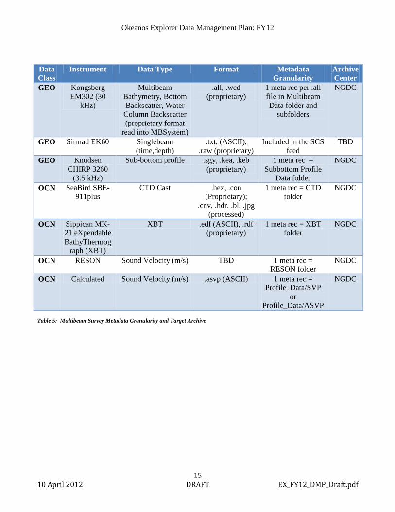
Data Class
Instrument Data Type Format Metadata Granularity
Archive Center
GEO Kongsberg EM302 (30
kHz)
Multibeam Bathymetry, Bottom Backscatter, Water
Column Backscatter (proprietary format
read into MBSystem)
.all, .wcd (proprietary)
1 meta rec per .all file in Multibeam Data folder and
subfolders
NGDC
GEO Simrad EK60 Singlebeam (time,depth)
.txt, (ASCII), .raw (proprietary)
Included in the SCS feed
TBD
GEO Knudsen CHIRP 3260
(3.5 kHz)
Sub-bottom profile .sgy, .kea, .keb (proprietary)
1 meta rec = Subbottom Profile
Data folder
NGDC
OCN SeaBird SBE-911plus
CTD Cast .hex, .con (Proprietary);
.cnv, .hdr, .bl, .jpg (processed)
1 meta rec = CTD folder
NGDC
OCN Sippican MK-21 eXpendable BathyThermog
raph (XBT)
XBT .edf (ASCII), .rdf (proprietary)
1 meta rec = XBT folder
NGDC
OCN RESON Sound Velocity (m/s) TBD 1 meta rec = RESON folder
NGDC
OCN Calculated Sound Velocity (m/s) .asvp (ASCII) 1 meta rec = Profile_Data/SVP
or Profile_Data/ASVP
NGDC
Table 5: Multibeam Survey Metadata Granularity and Target Archive

Okeanos Explorer Data Management Plan: FY12
16 10 April 2012 DRAFT EX_FY12_DMP_Draft.pdf
C. Video Data Archive Pipeline Low-resolution video segments will be archived at the NOAA Central Library (NCL) in Silver Spring, MD, a division of NODC. The raw, unAll of the medium and low-resolution video segments and their metadata will be temporarily stored in private and dedicated storage space on the NODC server and periodically backed up in a scheduled tape rotation.
Fig 3: Video Data Pipeline
Okeanos Explorer Data Management Plan: FY12
17 10 April 2012 DRAFT EX_FY12_DMP_Draft.pdf
Near Real-Time
Video segments to be preserved will be marked and saved onboard the EX through collaboration with the remote science team. These clips will be saved with embedded metadata – cruise ID, camera ID, date/time, lat/lon, and file name and saved in the Ship Board Repository Server (SBRS). These enhanced multimedia files will be transmitted via an automated process (outlined in Section VI-B) to the Shoreside Redistribution Server (SRS) and saved in two resolutions – medium-resolution and web-streaming low-resolution quality using a strict naming convention outlined in the “Okeanos Shore-Side FTP Server Standard Operating Procedures” document and in Section VI-C of this document.
Low-resolution images will be downloaded by NCDDC from the SRS for metadata generation routines. Image and video files will have embedded metadata and the file name will also include fields for the metadata. Daily logs generated by the Expedition Coordinator will also be pulled from the SRS as they become available. Dive tracks in kml format are pulled from the SRS as they become available.
Daily Logs and representative images and dive tracks and links to representative video clips are displayed on the Okeanos Atlas,
The embedded information and the file names of the downloaded low-res images will be used in the routines to produce the FGDC metadata for each low-resolution video clip. An FGDC metadata record will also be generated for the medium-resolution counterpart to the clip, although that clip will not be downloaded from the SRS. The generated metadata records will be named similarly to the video clips they represent and all metadata will be uploaded to the SRS in the same folder with the video clips. A manifest file with md5 checksum values will be generated daily for all of the video clips and metadata records available on the SRS. The manifest file will be uploaded to the SRS. Post-Mission
At the end of the mission, MARC metadata for each dive will be generated for video clips and framegrab images. All MARC metadata records are emailed to the NOAA Central Library for the mission catalog.
A final manifest file and md5checksum file are generated and uploaded to the SRS.
NODC automated routines will be in place to recognize when the md5 checksum file is available for processing. Video clips and corresponding metadata will be saved to NODC dedicated storage space and backed up to tape until such time that a permanent solution to high-definition video archive is available.

Okeanos Explorer Data Management Plan: FY12
18 10 April 2012 DRAFT EX_FY12_DMP_Draft.pdf
The NOAA Central Library will pull all of the low-res video clips from the NODC server and do a bulk ingest into their system, cataloging these clips by corresponding dive in their online video data management system (VDMS). Data Class
Instrument Data Type Format Metadata Granularity
Archive Center
MUL ROV/Sled Cameras
Low-res video clips h.264 low 1 MARC meta rec per each
NCL
MUL ROV/Sled Cameras
Medium-res video clips
h.264 med 1 FGDC meta rec per each
NODC/MDSD (temporary
hold) MUL ROV/Sled
Cameras Highlight Images .jpg 1 MARC meta rec
for the folder NCL
MUL ROV/Sled Cameras
Still images .jpg 1 MARC meta rec for the folder
NCL
MUL Topside Cameras
Still images .jpg 1 MARC meta rec for the folder
NCL
Table 6: Video Metadata and Target Archive

Okeanos Explorer Data Management Plan: FY12
19 10 April 2012 DRAFT EX_FY12_DMP_Draft.pdf
D. Geospatial Data and Products Pipeline
2/1/2011
Okeanos Explorer
NOAA Ship Okeanos Explorer Geospatial Data Products Pipeline (Near-real Time processes)
Daily
1
2
3
Shipboard sensor data summary
NCDDCOkeanos Atlas(Public access)
URI/GSO Redistribution Server (sftp)
Hourly
1 2 3
Automated hourly email provides ship navigation (position) oceanographic and meteorological sensor report
-RSS subscription to daily reports, posted to pubic and linked to enhanced content-Geospatial data products generated aboard ship each day may include enhanced ship track, seafloor imagery; CTD locations and data; dive locations, tracks, imagery and reports.
Okeanos Atlas: Automated (and semi-automated) processes integrate geospatial data into unified map display in near-real time.
Figure 4: Geospatial Data and Products Pipeline Detailed procedures are described in the Okeanos Atlas Standard Operating Procedures document found in Appendix E.
A periodic email (currently fifteen minutes) with the ship’s current location and a snapshot of sensor readings monitored through the ship’s SCS is automatically delivered to the NOAA Ship Tracker and also to the EX Data Management team at NCDDC. The vessel track and an hourly sensor snapshot information bubble are added to the Okeanos Atlas. As a backup, a ship track KML will be included in a daily ship-to-shore synchronization from the EX to the SRS.
Several automated and manual processes and procedures are implemented on a daily or as-available schedule:
• Daily automated procedures on the EX synchronize the data from the vessel networks to the agreed upon folder structure on the SRS.

Okeanos Explorer Data Management Plan: FY12
20 10 April 2012 DRAFT EX_FY12_DMP_Draft.pdf
• RSS feeds are received by the Data Management team at NCDDC with the Daily Updates posted on the Okeanos Explorer Portal. The Daily Update will be geospatially added to the Okeanos Atlas, based on the date of the update and the location of the ship at midnight on that date.
• The daily cumulative GeoTIF of bathymetric data are pulled from the SRS and geospatially overlayed on the map. Any existing GeoTIF is removed before the new one is added.
• As CTD casts are deployed, resulting processed data files and/or the raw unprocessed data are saved to the SRS. The Data Management team at NCDDC pulls the processed data or post-processes the raw data, thins the processed data, and plots a profile of the results. The spot of deployment of the CTD cast is geospatially placed on the map and the CTD profile plot can be invoked from that map element. Additionally, the user can compare the profile to the World Ocean Atlas average profile for a user-specified month.
• The tracks of the ROV and camera platform will be saved to the SRS in a KML format, displayable on the Okeanos Atlas.
• Highlighted images and/or video clips associated with a particular dive are regularly saved to OER’s Education and Outreach website, oceanexplorer.noaa.gov, after being released for public distribution through an SOP documenting the process. These images and/or video clips will be geospatially tagged, using the embedded spatial information, onto the map display and a link back to the oceanexplorer website will be provided.

Okeanos Explorer Data Management Plan: FY12
21 10 April 2012 DRAFT EX_FY12_DMP_Draft.pdf
VIII. Data Exchange Agreements and Archive Strategies During data management discussions at cruise planning meetings before any EX mission, an agreement shall be made as to the data types and formats that would be exchanged between the EX and any visiting scientists or international partners, if such is the case. These data management details will be included in the Cruise Plan appendix for Data Management and will include data formats, data exchange methods, and agreed upon time frames.

Okeanos Explorer Data Management Plan: FY12
22 10 April 2012 DRAFT EX_FY12_DMP_Draft.pdf
IX. Underwater Cultural Heritage (UCH) Data Responsibilities
A. In the course of acquiring or post-processing bathymetric data, features on the seafloor may be unexpectedly discovered which are of potential cultural or historical significance. These discoveries may include wrecks of ships or aircraft, the recognizable debris from wrecks, or other items which may appear anthropogenic in origin and have some associated cultural or historical significance. If such a situation arises, these data will require special consideration in data management.
The Expedition Coordinator will consult with OER’s Marine Archaeologist, who will contact other relevant entities to notify them of the discovery and consult with them regarding the significance of the discovery.
If the discovery is determined to be historically significant, the EX cruise Coordinator, a representative from the data management team, OER’s marine archaeologist, a representative from the Office of General Council, and any parties with legal management responsibilities or other legal ties to the resource shall meet to determine what measures to are needed to protect the UCH while minimizing impacts on the distribution of data and data products.
If it is determined that the discovery is not historically significant or it is determined that no harm will result by disclosing position information, no change to standard mapping data management procedures is required.

Okeanos Explorer Data Management Plan: FY12
23 10 April 2012 DRAFT EX_FY12_DMP_Draft.pdf
X. EX Iconographic Products Product Public
Release? Archive? Format/Size Archiv
e Center
Originator
Daily Situation Report No No .doc/ <500K n/a Expedition Coordinator
Daily Web Logs with Corresponding Image or Video Clip
Yes No .doc n/a Expedition Coordinator
Daily (during survey) Cumulative GeoTIF, Fledermaus .sd, ASCII text file, .png with polygon of daily progress and .kmz of Seafloor Bathymetry
No No GeoTIF, .sd, .txt, .png, .kmz
n/a Mapping Team Lead
ROV Dive Trailers Yes Yes .mov NCL Video team
Dive Highlight Videos Yes Yes .mov NCL Video team
Cruise Highlight Video (20-30 minute video with visual highlights)
Yes Yes . .mov/.pdf w/captions, credits
NCL Video team
Science Highlight Video (15-30 minute video with scientific highlights)
Yes Yes .mov NCL Video team
Dive Site Highlight Video (2-3 minute video)
Yes Yes .mov NCL Video team
Post-Mission Quick Look Report
Yes Yes .pdf/a NCL Lead Scientist
Post-Mission Final Cruise Summary Report*
Yes Yes .pdf/a NCL Lead Scientist
Post-Mission Final Cruise Mapping Data Report*
Yes Yes .pdf/a NCL, NGDC
Mapping Team Lead
Post-Mission Final Gridded Mapping Data Products*
Yes Yes GeoTIF (.tif), xyz grids (.txt), Fleder-maus objects (.sd), .png of drapped imagery .kmz of daily GeoTIF
NCL, NGDC
Mapping Team Lead

Okeanos Explorer Data Management Plan: FY12
24 10 April 2012 DRAFT EX_FY12_DMP_Draft.pdf
Table 7: Iconographic Products/Reports *Approval Process required before publishing Table 7 describes the current understanding of the reports and products that are expected to be generated as a result of an EX mission. These iconographic products will be vetted through an SOP to ensure the products are approved for public release or archive, if applicable. These products can be emailed to the Data Management Coordinator or picked up from the Okeanos Explorer Portal by the Data Management team when they are ready for archive. The products from the mapping survey team will be delivered via hard-drive several weeks post-cruise.

Okeanos Explorer Data Management Plan: FY12
25 10 April 2012 DRAFT EX_FY12_DMP_Draft.pdf
XI. Data Discovery and Access
A. Geographic Information Systems (GIS) A GIS application called Okeanos Atlas, developed and maintained at NCDDC, provides near real-time access to data and products transmitted via satellite to the SRS, pulled by the Data Management team, and geospatially displayed.
Figure 5: Okeanos Atlas There are a variety of data layers that are available for display on the Okeanos Atlas. The data layer selections are available on a collapsible left side menu for the user. These layers are described below: Global Data: Global data layers include:
• The Exclusive Economic Zone (EEZ) boundaries • The edges of the tectonic plates • Documented undersea volcano locations • Monthly sea surface temperature contours for a specified month
Local Data: Local data layers will vary according to what data layers are provided, if any, in preparation for a mission. Meteorological/Oceanographic/Navigational: The EX’s ship track and snapshot of selected METOC sensor observations along the track are displayed at 20 minute intervals. Some time after the cruise’s end, the track will be thinned to a daily track. The display of the ship observation icons can be toggled on and off. The user can view the snapshot of sensor data either by clicking on an icon or by selecting
Okeanos Explorer Data Management Plan: FY12
26 10 April 2012 DRAFT EX_FY12_DMP_Draft.pdf
a specific date/time on the right-side menu. Navigational tracks from the submersibles are also displayable by selecting the green dive dots or the green dive links on the right side menu. Results of off-board CTD casts are displayable by selecting the red dots or selecting the red CTD links on the right side menu. The thinned CTD profile is displayed in the position that it was deployed. The profile can be compared to the historical average for the same month from data from the World Ocean Atlas at NODC. Seafloor Bathymetry: At the completion of each survey day, a GeoTIF received from the Mapping Survey team will be added to the Atlas. This image will be displayable by selecting the gray dot or the gray link on the right side menu. This GeoTIF will not indicate actual depth values. Multimedia: Daily logs released by the EX expedition leaders will be displayed by selecting the yellow dots or the yellow links on the right side menu. Each Daily Update will have a link to a publically available article on the Okeanos Explorer Portal and will include a selected image. Those dives with corresponding video clips will be indicated by the ‘Vid’ suffix on the green dive link.
B. Education Expedition Modules and Lesson Plans OER’s Education Team will develop and Education Expedition Module (EEM) and specific lesson plans for the FY12 missions. The Data Management team will work with the Education team to provide some or all of the following for near real-time data to be used in these Education products:
• Multibeam xyz (lat, lon, depth) gridded data • Survey image for GIS overlay • 3-D fly-through imagery in a movie format • Ship navigation, meteorology, and oceanographic sensor data • Thinned CTD cast profile data for plotting

Okeanos Explorer Data Management Plan: FY12
27 10 April 2012 DRAFT EX_FY12_DMP_Draft.pdf
XII. Data Management Points of Contact The following are the points of contact for the successful implementation of this Data Management Plan in FY12:
• Lt. Megan Nadeau, OMAO, Okeanos Explorer Operations Officer, [email protected]
• Webb Pinner, OER, Okeanos Telepresence Team Lead, [email protected]
• Sharon Mesick, NCDDC, Integrated Product Team Lead, Federal Program Manager, [email protected]
• Susan Gottfried, NCDDC, OER Data Management Coordinator [email protected]
• Dave Fischman, NGDC, Geophysical Data Officer [email protected]
• Tom Ryan, NODC, Oceanographic Data Officer [email protected]
• Anna Fiolek, NCL, Librarian [email protected]
• Andrew Navard, NCDDC, Geospatial Tools [email protected]