operational and safety assessment proposed vail … · operational and safety assessment-proposed...
TRANSCRIPT

Page 1
Keith Mackey, PresidentMackey International
October 22, 2014
Operational and Safety Assessment-
Proposed Vail Valley Medical Center Heliport
Vail, Colorado

Page 2
I have been asked by a group of property owners in Vail to examine the master plan for a proposed heliport at the Vail Valley Medical Center, to be located on a multi-story parking garage located along South Frontage Road, from an operational and safety aspect and to identify factors that must be satisfied by the Town of Vail in order to approve heliport/helicopter operations as proposed. As of the date of this report, some areas of con-cern have been identified by the hospital proponent, however, as more details of the plan are made know by the hospital proponent, other issues may be discovered, therefore, I reserve the right to revise and extend the scope of this report as new information is received.
1. Qualifications - Opinions on the subject of helicopter operations are based on the following: a. Approximately 30,000 hours flying experience as a pilot. b. Type Rated in over 70 different aircraft models including 25 helicopter types at the Airline Transport Pilot level. (Highest level issued by the FAA.) c. Having flown equipment ranging from the very small Robinson R22 helicopter to the Boeing 747 as Captain in worldwide operations. d. Approximately 3,500 hours as a helicopter pilot and as a helicopter flight and instrument flight instructor. e. 20 years experience as CEO of helicopter company holding many FAA certifications including Part 135. During my tenure, the company held the contract to provide initial and recurrent training to all FAA helicopter operations inspectors for four years. f. Factory trained in the AS350 helicopter. (Helicopter currently used at Vail) g. Hold an FAA issued type rating in the AS350 at the ATP level. (Highest level issued by the FAA.) h. Experienced in operating helicopters at high elevations near the edge of the performance envelope. i. FAA certified Airframe and Powerplant mechanic with Inspection Authorization j. Trained accident investigator. My CV is attached as Appendix 1.
2. Factors considered - These areas were researched to form a basis for my opinions. a. Advantages of having hospital heliports near the emergency room rather than remotely located. b. Operational and accident history of HEMS (Helicopter Emergency Medical Service) operations. c. Factors that are unique to conducting HEMS operations in high altitude, mountainous areas. d. FAA regulatory, advisory and guidance information regarding helicopter landing area planning and construction and HEMS operations. e. Existing and planned helicopter arrival and departure routes in Vail. f. Potential effect of future construction near the current and proposed heliport locations, including redevelopment of the town’s municipal site. g. Helicopter types suitable for high altitude HEMS operations, including manufacturer and FAA performance and certification information.
3. Background and General Information - There can be no doubt that having a hospital heliport located in close proximity to the ER offers advantages including reducing the time needed to get a patient from an acci-dent scene via helicopter to the hospital, reducing the time needed to transport a patient to an off-site heliport and general convenience. The risks associated with building an elevated heliport to accomplish these goals must be balanced against the use of less convenient ground level heliport locations. A number of factors must be con-sidered to understand the risks involved before decisions are made as to the type and location of a heliport.
Helicopter Emergency Medical Service (HEMS) is a very difficult and potentially dangerous business. In a 2009 article, (Appendix 2) the Wall Street Journal cited Dr. Ira Blumen, of the University of Chicago Hospitals, who con-cluded that emergency medical helicopter pilots have the most dangerous jobs in the U.S. The danger, of course, is not only to the crew, but the patient as well.

Page 3
A number of factors make locating an elevated heliport at high elevations, such as Vail, difficult because of po-tential dangers. It is assumed that a hospital heliport in Vail will be used only for medical transportation and not open to general aviation. This would mean that all operations at the heliport would be limited to professional HEMS pilots experienced in mountainous operations and medical transportation. Even with this assumption, there are many aspects that could affect safety, ability to complete missions, and may present problems with financing, insurance, and may limit construction or additions on new or existing buildings in the area of the heliport. These factors must be examined in detail and fully understood before decisions about construction, location and design are made.
4. High Altitude and Mountainous Area Risk Factors - Compared to most of the rest of the US, the Colora-do Rockies have many hazards to helicopter flight. These include:
a. High altitudes and warm temperatures - Density Altitude (thickness of the air) - Vail is 8,150’ above sea level, but the air density is only at 8,150’ if the temperature is below 31°F. If the temperature is 79° F, the density altitude at Vail is over 11,000’. Aircraft performance is based on density altitude, not actual altitude. Actual altitude must be corrected for temperature to obtain density altitude in order to evaluate flight characteristics affecting safety of operations.
b. Mountain wave turbulence and rotor effect. In the winter, the jet stream frequently passes over the Vail area at altitudes low enough to impact the 14,000’ mountain peaks. The result is the potential for severe mountain wave and rotor turbulence as illustrated below. This turbulence must be avoided. Pilots flying in mountainous areas need special training, knowledge and experience to learn to avoid these hazards.
c. No trained aviation weather observer on site at the hospital. d. Snow, Ice, Freezing rain. e. Many structures near the hospital creating wind shadows and variable wind directions and velocities.
Page 4
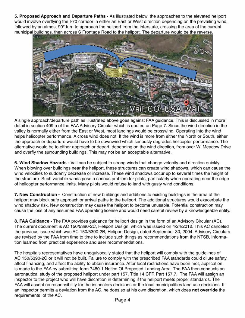
5. Proposed Approach and Departure Paths - As illustrated below, the approaches to the elevated heliport would involve overflying the I-70 corridor in either an East or West direction depending on the prevailing wind, followed by an almost 90° turn to approach the heliport from the interstate, crossing the area of the current municipal buildings, then across S Frontage Road to the heliport. The departure would be the reverse.
A single approach/departure path as illustrated above goes against FAA guidance. This is discussed in more detail in section 409 a of the FAA Advisory Circular which is quoted on Page 7. Since the wind direction in the valley is normally either from the East or West, most landings would be crosswind. Operating into the wind helps helicopter performance. A cross wind does not. If the wind is more from either the North or South, either the approach or departure would have to be downwind which seriously degrades helicopter performance. The alternative would be to either approach or depart, depending on the wind direction, from over W. Meadow Drive and overfly the surrounding buildings. This may not be an acceptable alternative.
6. Wind Shadow Hazards - Vail can be subject to strong winds that change velocity and direction quickly. When blowing over buildings near the heliport, these structures can create wind shadows, which can cause the wind velocities to suddenly decrease or increase. These wind shadows occur up to several times the height of the structure. Such variable winds pose a serious problem for pilots, particularly when operating near the edge of helicopter performance limits. Many pilots would refuse to land with gusty wind conditions.
7. New Construction - Construction of new buildings and additions to existing buildings in the area of the heliport may block safe approach or arrival paths to the heliport. The additional structures would exacerbate the wind shadow risk. New construction may cause the heliport to become unusable. Potential construction may cause the loss of any assumed FAA operating license and would need careful review by a knowledgeable entity.
8. FAA Guidance - The FAA provides guidance for heliport design in the form of an Advisory Circular (AC). The current document is AC 150/5390-2C, Heliport Design, which was issued on 4/24/2012. This AC canceled the previous issue which was AC 150/5390-2B, Heliport Design, dated September 30, 2004. Advisory Circulars are revised by the FAA from time to time to include such things as recommendations from the NTSB, informa-tion learned from practical experience and user recommendations.
The hospitals representatives have unequivocally stated that the heliport will comply with the guidelines of AC 150/5390-2C or it will not be built. Failure to comply with the prescribed FAA standards could dilute safety, affect financing, and affect the ability to obtain insurance. After local restrictions have been met, application is made to the FAA by submitting form 7480-1 Notice Of Proposed Landing Area. The FAA then conducts an aeronautical study of the proposed heliport under part 157. Title 14 CFR Part 157.7. The FAA will assign an inspector to the project who will have discretion in determining if the heliport meets proper standards. The FAA will accept no responsibility for the inspectors decisions or the local municipalities land use decisions. If an inspector permits a deviation from the AC, he does so at his own discretion, which does not override the requirements of the AC.

Page 5
Chapter 4 of AC 150/5390-2C is devoted to Hospital Heliports. There are several areas in this AC that present compliance issues for the proposed heliport. Understanding the abbreviations, definitions and acronyms used in the AC are necessary to full appreciate these issues. The following paragraphs contain important definitions and abbreviations:
Hospital heliport. A heliport limited to serving helicopters engaged in air ambulance, or other hospital related functions. A designated helicopter landing area located at a hospital or medical facility is a heliport and not a medical emergency site.
Heliport protection zone (HPZ). An area off the end of the FATO and under the approach/departure path intended to enhance the protection of people and property on the ground.
Approach/departure path. The flight track helicopters follow when landing at or departing from a heliport. The approach/departure paths may be straight or curved.
Touchdown and liftoff area (TLOF). A load-bearing, generally paved area, normally centered in the FATO, on which the helicopter lands and/or takes off.
Final approach and takeoff area (FATO). A defined area over which the pilot completes the final phase of the approach to a hover or a landing and from which the pilot initiates takeoff. The FATO elevation is the lowest elevation of the edge of the TLOF.
The AC specifies that the size of the touchdown and liftoff area (TLOF) shall be a minimum size of 1 x the rotor diameter of the largest helicopter to be accommodated or a minimum of 40 feet as is illustrated by dimensions A and B below:
The Final Approach and TakeOff area (FATO), dimension C and E on the above diagram, are specified to be a minimum of 11/2 times the overall length of the helicopter. Because helicopter performance decreases with altitude, resulting in a shallower climb gradient at higher altitude heliports, a correction must be applied to increase the FATO size to compensate for the shallower climb angle at high altitudes.
The FATO does not have to be square as in the above illustration. It could be circular, centered on the TLOF or could underly only the approach and departure paths for the heliport.

Page 6
The FATO size correction chart from the AC is figure 4-4 and is reproduced below. The chart provides correc-tions for altitude by requiring an increase in size of the FATO for heliports above 1,000’ elevation. Since almost all heliports in the US are at low altitudes, presumably, the FAA did not anticipate heliports would be construct-ed at the altitude of Vail and failed to provide the needed corrections for heliports above 6,000’.
Per the chart below, if the proposed heliport were at 6,000’ above sea level, a correction of 250’ would need to be added to dimensions C and E. Since data for elevations higher than 6,000’ is not provided by the Advisory Circular, without engineering data for higher altitudes, approved by the FAA, compliance with the Advisory Circular is not possible for the altitude of Vail. If the correction data were extrapolated from the chart, it ap-pears the correction would approach 450’. Without FAA approved data, the proper correction cannot be deter-mined. The FAA inspector tasked with approving the heliport can choose to ignore or modify the FATO correc-tion at his/her discretion, but such a deviation does not constitute compliance with the Advisory Circular.
The FATO is to be surrounded by a Safety Area which is dimension G. It is prescribed to be not less than 10’ and no correction for high altitude heliports is given.
Approach/departure paths. The proper size of the FATO must be determined by engineering means acceptable to the FAA administrator to correct for altitudes above the 6,000’ maximum elevation in figure 4-4 (above). This must be done to be able to properly locate the beginning of approach departure path at the edge of the FATO.
The purpose of approach/departure airspace as shown in Figure 4–6 (next page) is to provide sufficient air-space clear of hazards to allow safe approaches to and departures from the TLOF. The approach/departure path starts at the edge of the FATO and slopes upward at 8:1 (8 units horizontal in 1 unit vertical) for a distance of 4,000 feet. The approach/departure path is to be free of obstacles.
The FAA provides no correction to the 8:1 slope for high altitude heliports to compensate for decreased heli-copter performance at high density altitudes.
It is logical to assume that if the correction in FATO size for altitude is properly observed, the beginning of the 8:1 slope must be moved away from the TLOF sufficiently to account for decreased helicopter climb angle per-formance at high altitude heliports. For this reason, determining the proper size of the FATO is very important from a safety aspect and must be correctly measured.
Page 7
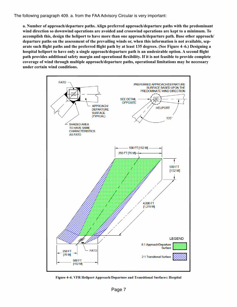
The following paragraph 409. a. from the FAA Advisory Circular is very important:
a. Number of approach/departure paths. Align preferred approach/departure paths with the predominant wind direction so downwind operations are avoided and crosswind operations are kept to a minimum. To accomplish this, design the heliport to have more than one approach/departure path. Base other approach/departure paths on the assessment of the prevailing winds or, when this information is not available, sep-arate such flight paths and the preferred flight path by at least 135 degrees. (See Figure 4–6.) Designing a hospital heliport to have only a single approach/departure path is an undesirable option. A second flight path provides additional safety margin and operational flexibility. If it is not feasible to provide complete coverage of wind through multiple approach/departure paths, operational limitations may be necessary under certain wind conditions.
Page 8
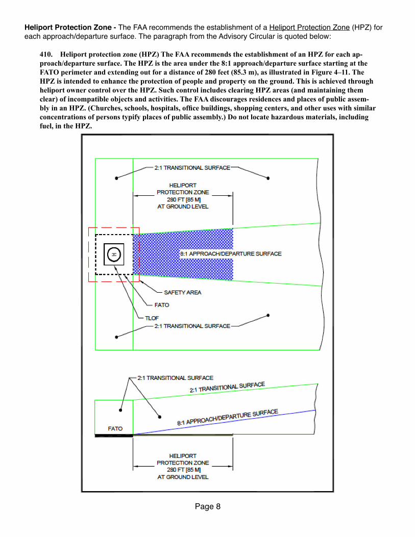
Heliport Protection Zone - The FAA recommends the establishment of a Heliport Protection Zone (HPZ) for each approach/departure surface. The paragraph from the Advisory Circular is quoted below:
410. Heliport protection zone (HPZ) The FAA recommends the establishment of an HPZ for each ap-proach/departure surface. The HPZ is the area under the 8:1 approach/departure surface starting at the FATO perimeter and extending out for a distance of 280 feet (85.3 m), as illustrated in Figure 4–11. The HPZ is intended to enhance the protection of people and property on the ground. This is achieved through heliport owner control over the HPZ. Such control includes clearing HPZ areas (and maintaining them clear) of incompatible objects and activities. The FAA discourages residences and places of public assem-bly in an HPZ. (Churches, schools, hospitals, office buildings, shopping centers, and other uses with similar concentrations of persons typify places of public assembly.) Do not locate hazardous materials, including fuel, in the HPZ.

Page 9
At the location of the proposed heliport, the hospital many not control the larger FATO, let alone the ground un-derlying the HPZ, as it overlies public roads, commercial and public buildings and residences and may contain hazardous materials over which the hospital has no control.
The present VVMC plan, as previously illustrated, provides for only a single North/South approach/departure path. Additional paths would require overflying obstacles which are also sensitive residential and commercial areas which contain areas of public assembly and would violate the HPZ recommendations of the FAA.Since it is not feasible to provide complete coverage of wind through multiple approach/departure paths, oper-ational limitations may be necessary under certain wind conditions which would result in canceled flights and reduced operational safety and reliability.
In summary, it will be very difficult if not impossible for the proposed heliport to comply with the FAA safety guidance:
a. The FATO area size cannot be determined, due to the elevation of Vail, without engineering data approved by the FAA. b. With that engineering data, it is likely that the size of the FATO would be so large as to cover surrounding residential, commercial areas and streets along the approach/departure paths. The FATO would limit the height of new construction or adding elevation to present structures. New construction could cause the closure of the heliport even if it were approved. c. The HPZ requirements cannot be followed due to the proximity of the heliport to heavily populated and trafficked areas not under the control of the hospital along and near the flight paths. It is unlikely that the hospital can acquire ownership of all these properties. d. It may not be possible to have more than one approach/departure path to the heliport due to present and future structures and heavily populated/trafficked areas. With only a single approach/departure path, unless the wind conditions area ideal, flight cancellations may frequently result. It would not always be possible to determine the exact wind situation until arriving at Vail, thus resulting in last minute flight cancellations after the helicopter has been dispatched. e. Even an alternative and safer ground level heliport at the proposed location may not be possible due to FATO size and 8:1 protected areas that may contain existing and proposed obstacles
9. Helicopter Performance and Weight Limitations - Because of their high altitude performance capabilities, the Airbus Helicopters, AS 350 B3 and Bell 407 are the type helicopters normally used at high elevation loca-tions in Colorado. The AS 350 B3 is arguably the more capable and has been frequently used for operations at the present Vail heliport; thus for simplicity, the following discussion will deal with that make/model.
To understand performance issues, it is first necessary to have some basic knowledge of helicopter aerody-namics. Helicopters require more power to hover than at any other time during a flight. Much less power is required for normal cruising flight than for hovering; hence, helicopters can fly from point to point at altitudes much higher than the altitude at which they can hover.
When a helicopter hovers close to the ground, over a smooth flat surface, a cushion of compressed air is formed below the machine by the downward flow of air through the rotor system. This compressed air is called “Ground Effect” and it lowers density altitude which allows the pilot to reduce the pitch of the rotor blades, thus using less engine power. When hovering within about 18 feet of a smooth level surface where this air cushion is present, the helicopter is said to be “Hovering In Ground Effect” which is abbreviated as HIGE.
Once the helicopter increases the height of the hover over the surface, to the point that the cushion of compressed air is lost, more power is required to hover. This condition is called “Hovering Out of Ground Effect” or HOGE.
While transitioning from a hover to forward flight, the rotor blades become more efficient as forward airspeed increases. Between 16 and 24 knots, the rotor system completely outruns the recirculation of old vortices and begins to work in relatively undisturbed air, which makes the rotor system operate more efficiently. This increased efficiency requires less engine power and continues with increased airspeed until the best climb airspeed is reached.

Page 10
When planning a flight to a high elevation landing site, the pilot must know if the helicopter will be capable of hovering out of ground effect, or only in ground effect, or that no hovering will be possible. When hovering is not possible, and a long smooth landing surface is available, such as a road, pilots can make a “running” land-ing, similar to an airplane landing, although at much lower speeds. A running landing would not be possible at a small elevated heliport.
Manufacturers are required by the FAA to provide performance charts that allow the pilot to determine the max-imum weight at which both in ground effect hover (HIGE) and out of ground effect hover (HOGE) is possible.
An examination of the manufacturer’s AS 350 B3 hover In ground effect capability (HIGE) chart reveals that at all temperatures likely to be encountered at Vail, there is no penalty in the form of gross weight reduction need-ed to hover close to the ground.
The out of ground effect (HOGE) chart below, however, presents a major problem. The maximum gross weight of the helicopter is 4,961 lbs. (2,250 kg). The aircraft can only hover out of ground effect at that weight up to a temperature of 68°F (20°C). At 86°F (30°C) a 261 pound reduction of the gross weight is needed to provide HOGE capability.
Page 11
The average empty weight of a fully equipped AS 350 B3 as used at Vail is approximately 3,800 lbs. This was determined by interviewing a pilot familiar with the Vail operation. Below is a sample weight calculation of what might be a typical flight:
Helicopter empty weight - Fully equipped for HEMS operations. 3,800 Pilot with clothing and flight equipment 200 Two person medical team with clothing and personal gear 360 Patient 200 Fuel 60 gallons @ 6.7 Lbs/gallon 401 Gross takeoff weight 4,961
The helicopter fuel capacity is 143 gallons. 60 gallons of fuel is probably sufficient to reach the Denver area in most conditions. If the patient weighed 300 lbs or if a longer flight was needed, the operation may not be possible.
If the temperature exceeded 68°F, a reduction in the gross takeoff weight would be needed as indicated in the chart on the previous page. On a warm day, the reduction could be large enough to require flight cancellation.
Flights that use the current ground level heliport, due to the surrounding level surface, are able to transition from liftoff to forward flight while remaining in ground effect the entire time; hence there is no need to have out of ground effect hover capability. The maximum certified weight of 4,961 lbs is below the in ground effect hover capability.
If using the proposed elevated heliport, as soon as the helicopter passes over the edge of the building, it is instantly out of ground effect. Even if operating at a temperature / weight combination that provides HOGE ca-pability, the aircraft would be at the edge of it’s performance envelope over a populated area. Any unexpected wind shift, engine performance degradation or other unanticipated problem could turn into a disaster.
11. Helicopter Mechanical Failure Emergencies - First, a bit of helicopter aerodynamics. If a helicopter experiences any type of drive train failure, which includes failure of the engine, main transmission, drive shafts, couplings, tail rotor gearbox and tail rotor, it is necessary to enter an “autorotation” which is the state of flight where the main rotor system of a helicopter is being turned by the action of air moving up through the rotor rather than engine power driving the rotor. In normal, powered flight, air is drawn into the main rotor system from above and exhausted downward, but during autorotation, air moves up into the rotor system from below as the helicopter descends.
Several factors affect the rate of descent in autorotation: density altitude, gross weight, rotor rpm, and air-speed. To make a safe autorotation, sufficient energy must be available to descend to the surface and land the helicopter. Energy is stored 3 places or “banks”. They are the potential energy stored in altitude, the potential energy stored in forward airspeed and the kinetic energy stored in the rotor rpm.
After a drive train failure, the pilot uses the energy stored in the altitude bank to descend to a point about 50’ above a hard, smooth landing surface. He then slows the helicopter by taking the energy out of the airspeed bank, until the helicopter is stopped, The pilot then increases the pitch of the rotor blades to extract the energy from them and make a safe touchdown. In a proper autorotation, all the stored energy is being used to execute a safe landing.
A safe takeoff profile for a helicopter requires the pilot to fly along a prescribed profile which allows the aircraft to gain sufficient airspeed energy before climbing to assure sufficient energy is always available for a safe autorotation. Helicopter manufacturer’s perform flight testing for each helicopter type and produce a height/velocity diagram which shows the proper combination of speed/altitude that must be maintained to be able to perform a successful autorotation.

Page 12
The height/velocity diagram or H/V curve is a graph charting the safe/unsafe flight profiles relevant to a specif-ic helicopter type. As operation outside the safe area of the chart can be fatal in the event of a power or drive train failure, it is sometimes referred to as the dead man’s curve by helicopter pilots. By carefully studying the height/velocity diagram, a pilot is able to avoid the combinations of altitude and airspeed that may not allow sufficient time or altitude to enter a stabilized autorotative descent.
In the simplest explanation, the H/V curve is a diagram in which the shaded areas should be avoided, as the pilot may be unable to complete an autorotation landing without damage.
The shaded area A represents the combination of airspeed and altitude from which it may be impossible to make a safe autorotation due to lack of sufficient stored energy to execute the maneuver.
Shaded area B on the lower right is dangerous due to the airspeed and proximity to the ground resulting in dramatically reduced reaction time for the pilot in the case of mechanical failure, or other in-flight emergencies.
Below is an example of a generic H/V diagram. Using this H/V information, A normal departure profile would follow the red line in the illustration below, gradually accelerating to 55 knots before reaching 100 feet and then continuing climb at 55 knots remaining clear of the shaded areas at all times in order to assure capability of a safe autorotation.
If hovering out of ground effect, the helicopter would have to be at least 450’ above a suitable landing area to make a safe autorotation, as the pilot would need sufficient altitude to convert to airspeed to be able to make a successful autorotation.

Page 13
Below is a copy of the Height / Velocity Envelope for the AS 350 B3 which is the type helicopter frequently used for the present Vail operation. It is a bit more complicated than the previous chart, as it takes into account altitude and temperature to provide density altitude compensation. The shaded area around the large letter “Z” corresponds to the “Avoid” area in the previous chart.
In the chart above, Point “A” is the initial hover height as the helicopter lifts off. Point “B” is a speed of 40 knots and is the point where a climb can begin to reach the minimum safe speed the helicopter must obtain before leaving an altitude of 100’. That minimum safe speed is Point “C” and is found by using the temperature, alti-tude and helicopter weight information which is entered into the chart.
This chart, unfortunately, stops at 7,000’ density altitude. At that altitude, the “C” point, which is the speed to which the helicopter should reach before climbing above 100’, has increased from about 48 knots to 64 knots. The density altitude in Vail can exceed 11,000’ in the summer.
Page 14
Since we have no data for that altitude, and since the AS 350 B3 is marketed as a high altitude machine, Air-bus Helicopters was asked for Height /Velocity information for higher density altitudes. Below is their reply:
The AS350 B3e is certificated according to the requirements of FAR 27. In this document §79 requires the limiting height-speed envelope to be established from sea-level up to 7000ft density altitude. §51 requires the definition of a take-off procedure that allows a safe landing at any point along the flight path if an engine fails. This regulatory requirement is also limited to altitudes from sea-level up to 7000ft density altitude. The above mentioned performances were not evaluated at altitudes higher than 7000ft density altitude and are therefore not mentioned in the Rotorcraft Flight Manual.Furthermore, the height/velocity envelope is an “avoid” zone. Flight in this zone is not forbidden and opera-tional needs such as flight with an external load or take-off at high altitude may make it necessary to operate within this envelope.
Airbus is telling us that they were not required to provide the high altitude information by the FAA and hence, have not done so. They tell us effectively to ignore the H/V chart in spite of the risk at high altitude as there is no guarantee of a safe landing above 7,000’ density altitude. Should an engine or drive train failure occur at higher altitudes, the pilot becomes a “test pilot” and is given no guidance as to how to proceed. The safest departure profile, since the “C” point on the chart cannot be determined at high altitude, would be to acceler-ate to the fastest speed possible before climbing. This is best done over a wide flat open area such as an airport or the I-70 corridor and certainly not over a built up area.
12. Conclusions and Opinions - In my opinion, the present ground level heliport, although not close to the hospital ER, is operationally much safer and provides greater scheduling reliability than would a heliport at the elevated parking garage or a ground level heliport at the same proposed location. There are a number of fac-tors, as previously noted that are negatives:
a. Compliance with many of the requirements of FAA AC 150/5390-2C, Heliport Design. is not be possible, or would be extremely difficult. b. Heavily congested areas must be overflown during arrivals and departures at low altitude AND without overflying residences and congested areas at very low altitude, only a single approach with a reverse course departure path would be possible. c. Such a limiting approach/departure path may frequently have a downwind component, thus severely limiting operations and reliability by causing cancellations due to wind conditions and making emergency procedures impossible or ineffective with disastrous consequences.. d. Helicopters would be operating very close to performance limits with little or no margin for error or mistakes. Summer temperatures could cause flight cancellations. e. Adding additional stories to existing structures or new construction near the proposed heliport Would either not be permitted, or could force heliport closure by blocking flight paths and creating wind shadows and turbulence.
As opposed to the current location, the proposed heliport would have a much greater risk of an accident, the results of which are likely to be much more serious due to the surrounding congested areas and limited flight paths. There is little doubt that such an accident in Vail would be very high profile and would bring scrutiny as to why, with all the risk factors either known or knowable, such an elevated heliport had been constructed.
There may be other locations in the Vail area that do not have the insurmountable safety negatives caused by heliport proximity to the emergency room that would offer much safer and more reliable options. I strongly sug-gest that alternate sites at ground level be explored to avoid the potential problems of the present proposal.
If asked to approve this, as an expert in helicopter operations, I would never do so. Especially since it is likely that safe alternative sites are available.