operations series addp 3.3 joint airspace control€¦ · this third edition of addp 3.3—joint...
TRANSCRIPT
ADDP 3.3
Edition 3
OPERATIONS SERIES
ADDP 3.3
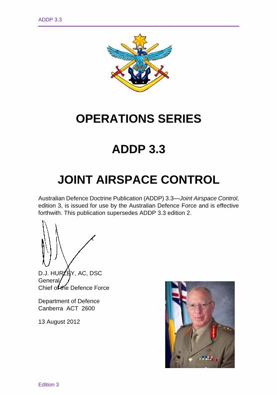
JOINT AIRSPACE CONTROLAustralian Defence Doctrine Publication (ADDP) 3.3—Joint Airspace Control, edition 3, is issued for use by the Australian Defence Force and is effective forthwith. This publication supersedes ADDP 3.3 edition 2.
D.J. HURLEY, AC, DSCGeneralChief of the Defence Force
Department of DefenceCanberra ACT 2600
13 August 2012
Defence Publishing ServiceDPS: September/2012
Edition 3
© Commonwealth of Australia 2012
This work is copyright. Apart from any use as permitted under the Copyright Act 1968, no part may be reproduced by any process without prior written permission from the Australian Government Department of Defence.
Announcement statement—may be announced to the public.
Secondary release—may be released to the public.
All Defence information, whether classified or not, is protected from unauthorised disclosure under the Crimes Act 1914. Defence information may only be released in accordance with the Defence Security Manual and/or Defence Instruction (General) OPS 13–4—Release of Classified Defence Information to Other Countries, as appropriate.
ADDP 3.3First edition 2004
Second edition 2008Third edition 2012
Sponsor Chief of Joint OperationsHeadquarters Joint Operations Command
Developer Director Australian Defence Force Warfare CentreWILLIAMTOWN NSW 2314
Publisher Defence Publishing ServiceDepartment of DefenceCANBERRA ACT 2600

ADDP 3.3
Edition 3 iii
PREFACE
1. Australian Defence Doctrine Publications (ADDPs) and Australian Defence Force Publications (ADFPs) are authorised joint doctrine for the guidance of ADF operations. ADDPs are pitched at the philosophical and high-application level, and ADFPs at the application and procedural level. Policy is prescriptive as represented by Defence Instructions, and has legal standing. Doctrine is not policy and does not have legal standing; however, it provides authoritative and proven guidance, which can be adapted to suit each unique situation.
2. This third edition of ADDP 3.3—Joint Airspace Control builds on the second edition issued in 2008. ADDP 3.3 focuses on the operational level of conflict, with some tactical level application. It provides guidance in the preparation, planning and conduct of airspace control (in defence of Australia and its territories) and for expeditionary operations across the spectrum of conflict. This will apply whether the force is required to operate within the area of influence of an existing airspace control system, or where no such system exists.
3. Although ADDPs are usually pitched at the philosophical and high application level, ADDP 3.3 includes some lower application level doctrine as there is insufficient material to warrant its inclusion in a separate ADFP.
4. Principal related publications include:
• ADDP–D—Foundations of Australian Military Doctrine, which outlines the strategic military doctrine of the ADF.
• ADDP D.3—Joint Operations for the 21st Century, which builds upon Force 2020.
• ADDP 3.0—Campaigns and Operations, which describes design, operational art and campaigning, and details the relationships between the national strategic, military strategic, operational and tactical levels of conflict for the conduct of campaigns and operations.
• ADDP 3.1—Joint Fire Support, which describes the application of joint fires in a joint force area of operations.
• ADDP 3.2—Amphibious Operations, which describes the nature and conduct of amphibious operations.
ADDP 3.3
iv Edition 3
• ADDP 3.16—Counter Air, which describes the nature and scope of activities required for counter air operations.
• Australian Maritime Doctrine (RAN Doctrine 1—2010), which describes how the RAN operates as part of a joint force to accomplish Australia’s maritime security goals.
• Land Warfare Doctrine 1—Fundamentals of Land Warfare, which describes how the Australian Army operates as part of a joint force.
• AAP 1000–D The Air Power Manual, which describes the application of air power and how it integrates into a joint force.
• AAP 1002 The Operational Air Doctrine Manual, which describes how the RAAF contribution to campaigns and operations is applied.
• AAP 1001.1 Command and Control in the Royal Australian Air Force.
ADDP 3.3
Edition 3 v
AMENDMENTS
Proposals for amendment of ADDP 3.3 may be sent by minute or email to:
Director Joint Doctrine Australian Defence Force Warfare Centre RAAF Base WILLIAMTOWN NSW 2314 [email protected]
Amendment Effected Number Date Signature Date
DOCTRINE PUBLICATION HIERARCHY The hierarchy of ADDPs and ADFPs and the latest electronic version of all ADDPs and ADFPs are available on:
DRN located at: http://intranet.defence.gov.au/vcdf/sites/adfwc/; and DSN located at: http://web.wlm.nnw.dsn.defence.mil.au/adfwc/
ADDP 3.3
vi Edition 3
CONTENTS Authorisation ii Preface iii Amendments v Contents vi List of figures and tables ix Paragraph Chapter 1 INTRODUCTION TO AIRSPACE CONTROL Campaigns and operations 1.2 The operational environment 1.4 Fundamental definitions 1.7 Deconfliction 1.15 Airspace control and control of the air 1.16 Networked operations 1.18 Flexible use of airspace 1.21 Theatre air control system 1.23 Chapter 2 AIRSPACE CONTROL SYSTEM Introduction 2.1 Functions of the airspace control system 2.4 Airspace structure 2.5 Policies, directives and plans 2.7 Command and control 2.10 TACS AGENCIES Air and space operations centre 2.15 Air component coordination element 2.17 Air support operations centre 2.19 Tactical air control party 2.21 Air traffic services 2.29 Joint terminal attack controller 2.32 COMMUNICATION AND INFORMATION SYSTEMS Collaborative planning and execution tools 2.39 Communication systems 2.41 SENSORS AIRSPACE USERS Annex: A. The airspace control system 2A-1 Chapter 3 PLANNING Introduction 3.1

ADDP 3.3
Edition 3 vii
PLANNING PRODUCTS PLANNING PROCESS Establish airspace control requirements 3.8 Establish capability requirements 3.16 Establish communication and information system requirements 3.18 Establish rules and procedures 3.19 Establish timelines 3.23 Risk management 3.24 Airspace control planning factors 3.25 AIRSPACE USER PLANNING CONSIDERATIONS Maritime operations 3.28 Land operations 3.32 Air operations 3.34 Special operations 3.36 Amphibious operations 3.37 Unmanned aerial systems 3.41 Joint fires areas 3.43 Annexes: A. Airspace control directive template 3A-1 B. Airspace control plan template 3B-1 C. Airspace control planning factors aide-memoire 3C-1 Chapter 4 EXECUTION Introduction 4.1 AIR TASKING CYCLE Deliberate airspace control means 4.7 Dynamic airspace control means 4.8 Chapter 5 AIRSPACE CONTROL MEANS Introduction 5.1 TYPES OF AIRSPACE CONTROL MEANS Coordinating altitude 5.6 Airspace coordination area 5.9 High density airspace control zone 5.10 Restricted operating zone 5.12 Air-to-air refuelling 5.14 Specialist routes 5.15 Other representative airspace control means 5.23 Airspace manoeuvre symbols 5.34 GLOBAL AREA REFERENCE SYSTEM GARS design 5.41 GARS nomenclature 5.43 Employing GARS in the airspace control system 5.48
ADDP 3.3
viii Edition 3
JOINT FIRES AREAS Naming convention 5.65 Terminology 5.66 Coordination 5.68 Annexes: A. Airspace control means request 5A-1 B. Airspace coordination terms 5B-1 C. Airborne radio procedures 5C-1 D. Joint fires areas examples 5D-1 E. Joint fires area request/ coordination form 5E-1 Chapter 6 CONTROL AND COORDINATION PROCEDURES Introduction 6.1 Separation and segregation 6.3 CONTROL PROCEDURES Positive control 6.6 Procedural control 6.8 Subordinate airspace control areas 6.10 COORDINATION PROCEDURES Airspace deconfliction 6.14 Maritime airspace coordination 6.15 Joint fire support coordination 6.18 UNMANNED AERIAL SYSTEMS
ADDP 3.3
Edition 3 ix
LIST OF FIGURES
Figure Page
1-1 Indicative airspace users 1-3
1-2 Networked force model supporting airspace control 1-6
2-1 Mobile Control and Reporting Centre Camp Palomino, 2-9 Kandahar Airfield, Afghanistan
2-2 Air traffic control Banda Aceh—Operation SUMATRA 2-10 ASSIST, 2005
2-3 Combat controllers support the Reconstruction Task Force 2-11
in Afghanistan
2-4 Secondary surveillance radar 2-15 2A-1 The airspace control system 2A-1 3-1 ADF personnel staffing Baghdad International Airport 3-5
Tower—Operation CATALYST, Nov 2003
3-2 Artillery providing offensive support 3-9 3-3 Mobile Control and Reporting Centre cabin, 3-10
based at Kandahar Airfield, Afghanistan
3-4 Special Operations Task Group personnel 3-11 preparing for insertion by helicopter, Afghanistan, Oct 2009
4-1 Air tasking cycle 4-3 5-1 Airspace control means 5-2 5-2 Coordinating altitude 5-4 5-3 Airspace coordination area 5-5 5-4 High density airspace control zone 5-6 5-5 Restricted operating zone for airborne operations 5-8 5-6 Minimum risk route 5-9
ADDP 3.3
x Edition 3
5-7 Standard use aircraft flight routes 5-10 5-8 Ship control zone 5-11 5-9 Airspace manoeuvre symbols 5-13 5-10 Global Area Reference System graphical depiction 5-16 5-11 Notional three-dimensional joint fire area 5-20 5-12 Joint fires area terminology 5-24 6-1 F/A 18 Hornets patrol Melbourne airspace during the 6-4 2006 Commonwealth Games 6-2 Maritime airspace coordination with situational 6-5
awareness
6-3 Maritime airspace coordination without situational 6-6 awareness
6-4 Lateral deconfliction 6-8 6-5 Altitude deconfliction—above MAXORD 6-9 6-6 SHADOW 200 unmanned aerial system 6-11 6-7 Unmanned aerial system aircraft flight profile 6-13

ADDP 3.3
Edition 3 xi
LIST OF TABLES
Table Page 3B-1 Airspace authorities and agencies 3B-4 3B-2 Commanders’ responsibilities 3B-5 5B-1 Airspace coordination terms 5B-1 5C-1 Aircrew joint fires area coordination 5C-3
card

ADDP 3.3 Chapter 1
Edition 3 1–1
CHAPTER 1
INTRODUCTION TO AIRSPACE CONTROL
Executive Summary
• Aircraft must safely operate in close proximity to surface, sub-surface and air launched weapons as well as other non-kinetic weapons such as smoke, lasers or electronic attack.
• Airspace control is a vital enabler designed to increase operational effectiveness by synchronising and de-conflicting air activities.
• Airspace users have unique characteristics and requirements, which need to be integrated into the airspace control system to facilitate flexible operations.
• Air aspects of ADF campaigns and operations are managed by the theatre air control system (TACS).
Scope
1.1 Australian Defence Doctrine Publication (ADDP) 3.3—Joint Airspace Control covers:
• the operational context and fundamental concepts applicable to joint airspace control;
• the airspace control system;
• airspace control planning;
• execution of airspace control;
• airspace control means (ACM); and
• airspace control and coordination procedures.
ADDP 3.3 Chapter 1
1–2 Edition 3
Campaigns and operations
1.2 A campaign is a set of military operations planned and conducted to achieve a strategic objective within a given time and geographical area. Operations are the building blocks of campaigns. An operation is a designated military activity using kinetic and non-kinetic means to achieve lethal and/or non-lethal effects.
1.3 The air contribution to ADF campaigns and operations is managed by the TACS, described later in this chapter.
Refer to ADDP 3.0—Campaigns and Operations for further guidance.
The operational environment
1.4 The operational environment (OE) embraces all the elements, conditions and circumstances which may influence the employment of capabilities and the decisions of the commander during campaigns and operations. The OE comprises four physical domains: maritime, land, air and space, and two non-physical domains: information and human. The information domain includes the electromagnetic spectrum sub-domain, and the cyberspace sub-domain.
1.5 In the air domain, aircraft must safely operate in close proximity to surface, sub-surface and air launched weapons as well as other non-kinetic weapons such as smoke, lasers or electronic attack. Capability degradation and the risk of fratricide can be minimised by de-conflicting airspace use. Airspace control is therefore a critical enabler for operational effectiveness.
1.6 Figure 1–1 illustrates typical airspace users and their airspace requirements. Figure 1–1 is indicative only and does not show all elements of the TACS.
ADDP 3.3 Chapter 1
Edition 3 1–3
Figure 1–1: Indicative airspace users
Fundamental definitions
1.7 Airspace. Airspace is the zone next to the earth consisting of atmosphere capable of sustaining flight.
1.8 Airspace management. Airspace management is the design, allocation, integration and regulation of airspace and airspace use.
1.9 Airspace control. Airspace control is the real time or near real time implementation of the airspace management procedures governing airspace usage in order to mitigate risk and enhance the flexible use of airspace.
1.10 Control of the air. Control of the air, as distinct from airspace control, is the ability to conduct friendly air and surface operations without interference from adversary air power.
1.11 Air battle management. Air battle management (ABM) provides control of military air operations in an area of operations and
ADDP 3.3 Chapter 1
1–4 Edition 3
may include the control and coordination of defensive counter air, offensive counter air, strategic attack, close air support and other warfighting or supporting air activities. ABM is normally conducted under the authority of the nominated joint force air component commander (JFACC). ABM can be conducted from ground, maritime or air bases and includes the provision of surveillance, early warning airspace control and air battle direction.
1.12 Battlefield airspace control. Battlefield airspace control (BAC) is an airspace control service provided to promote the safe, efficient and flexible use of airspace within a land based tactical area of responsibility in support of the scheme of manoeuvre. BAC is designed to prevent collisions and fratricide and to allow force elements to operate aircraft and weapon systems within the airspace control area with maximum freedom, consistent with the degree of risk acceptable to the joint commander. BAC functions may include deployed air base air traffic services as well as the real time integration, coordination and deconfliction of airspace in support of air operations. A typical example of BAC is the service provided by the airspace control element within a tactical air control party (TACP) supporting a land formation headquarters.
1.13 Separation. Separation is the application, by appropriately trained and endorsed personnel, of authoritative separation standards in real time between the possible positions of aircraft.
1.14 Segregation. Segregation is the application of procedural measures that are deliberate by nature and designed to resolve/eliminate potential conflict or overlap between the possible positions of airspace users, provided those users operate and function as expected or instructed. Although segregation may be based upon separation principles, it does not require real time or near real time intervention.
Deconfliction
1.15 Deconfliction is the act of reducing the risk of collision between aircraft and other airborne hazards by coordinating their movements in time or space. Effective and efficient deconfliction allows commanders maximum freedom of action in the air domain while minimising the risk of fratricide and equipment loss. Deconfliction is achieved through segregation and/or separation.
ADDP 3.3 Chapter 1
Edition 3 1–5
Airspace control and control of the air
1.16 Airspace control and control of the air are fundamentally different concepts. Control of the air implies that some degree of dominance in the air domain is achieved, for example air superiority. Airspace control, on the other hand, is a vital enabler for the conduct of operations and occurs with or without control of the air. Airspace control is primarily a command and control function, and designed to increase operational effectiveness by synchronising and integrating air activities in time, space and purpose to maximum effect.
Refer to ADDP 3.16—Counter Air and Australian Air Publication 1000–D—The Air Power Manual for further guidance.
1.17 Whenever airspace is required for the conduct of exercises, preparatory training or operations, there is a requirement for airspace control. Multiple users support the joint commander in different ways, such as air defence, counter air, air mobility and joint fire support. The specific characteristics and requirements of these airspace users must be integrated and coordinated to make best use of the airspace.
Networked operations
1.18 A networked force derives its power from linking different elements of the organisation to operate more effectively through greater situational awareness. The airspace control system operates as part of the wider ADF networked force and links all airspace users who need to exchange information for the control and coordination of airspace.
1.19 The networked force model can be used to illustrate the airspace control system (see figure 1–2). Sensors conduct surveillance and provide spatial and identification data and information to the airspace control system. The command and control elements use this data and information to develop a picture of the non-real time operating environment known as the common operating picture, which is used for coordinating airspace and de-conflicting airspace use.
1.20 Information and data is also distributed to airspace users via Tactical Data Links and communications networks in real or near real time in the form of the common tactical picture (CTP). Airspace users may have sensor systems that provide surveillance and identification data and information to the network to enhance the CTP. Both airspace users and surveillance assets gain situational awareness from the CTP.

ADDP 3.3 Chapter 1
1–6 Edition 3
Figure 1–2: Networked force model supporting airspace control
Flexible use of airspace
1.21 The flexible use of airspace (FUA) refers to the aspiration to better integrate civil and military airspace control systems and airspace usage to ensure access to airspace is not unnecessarily denied by or to either party. FUA encourages both military and civilian agencies to proactively share airspace whenever it is safe and operationally acceptable.
1.22 Ownership of airspace is not necessarily a significant issue, provided the airspace is used safely and efficiently in accordance with priorities and desired effects. The FUA concept will evolve as technologies, requirements and strategic circumstances change. Airspace planners and control agencies should ensure that the airspace control system accommodates FUA whenever practicable.
Theatre air control system
1.23 Air aspects of ADF campaigns and operations are managed within the TACS, which employs a system of agencies extending from
ADDP 3.3 Chapter 1
Edition 3 1–7
the operational level down to the tactical level, allowing for the centralised planning and control, and the decentralised execution, of joint air operations. The structure of the TACS can be tailored to suit operational circumstances, force structure, command structure, available assets and campaign objectives.
1.24 TACS agencies under the control of an air commander may include:
• air component coordination element;
• air and space operations centre;
• air support operations centre;
• control and reporting centre, including control and reporting units, and airborne early warning and control;
• tactical air control party (TACP), including the airspace control element; and
• amphibious airspace control element.
1.25 TACS agencies with airspace control functions or responsibilities are detailed in later chapters of this publication.
ADDP 3.3 Chapter 2
Edition 3 2–1
CHAPTER 2
AIRSPACE CONTROL SYSTEM
Executive Summary
• The airspace control system comprises the people, procedures and equipment required to deliver airspace control.
• Effective airspace control relies on networked operations.
• A single airspace control authority ensures unity of effort through centralised planning and control.
• Communications and information systems (CIS) are a critical element of the airspace control system.
Introduction
2.1 The airspace control system consists of those organisations, personnel, policies, procedures and facilities required to perform airspace control functions. Every commander who needs to use airspace should understand and engage with the airspace control system to ensure their operational needs are met. Airspace users do not have to own the airspace or the air assets to achieve their desired effects in the air domain. Rather, they need to ensure that the appropriate control measures are in place to support operations.
2.2 Civilian authorities and systems may need to be accommodated by the military airspace control system.
2.3 The main elements of the airspace control system are the airspace control agencies, airspace design and structure and airspace control procedures. The airspace control agencies and airspace design and structure are detailed in this chapter, while airspace control procedures are detailed in chapter 6—‘Control and Coordination Procedures’.
ADDP 3.3 Chapter 2
2–2 Edition 3
Functions of the airspace control system
2.4 The functions of the ADF airspace control system are to:
• maximise freedom of action within the air domain, consistent with the degree of risk acceptable to the commander;
• facilitate the safe, efficient and flexible use of airspace;
• prevent fratricide and equipment loss;
• optimise the coordination of maritime, land, air and special operations forces within the airspace;
• facilitate rapid detection, identification, interception and destruction of hostile air threats;
• ensure that the airspace remains safe and useable, including when communications, surveillance capability and visibility are degraded;
• support 24 hour operations in all weather and environmental conditions; and
• integrate military airspace users with host nation and multinational airspace activities.
Airspace structure
2.5 Unnecessarily complex airspace control systems undermine combat effectiveness, waste resources and potentially increase the risk of fratricide. When complex sub-divisions of airspace are unavoidable, the airspace control system should maximise interagency coordination on a dynamic basis. This will overcome the need for individual airspace users to establish direct communications with every airspace control agency.
2.6 Airspace structure may be dictated by:
• the geographical size of the joint force area of operations (JFAO);
• the airspace needs of particular users, such as airbases, maritime task groups, fire support coordination authorities and

ADDP 3.3 Chapter 2
Edition 3 2–3
unmanned aerial systems;
• the nature of operations;
• geopolitical circumstances;
• threat assessment;
• topography; and
• air-ground-air and interagency communications.
Policies, directives and plans
2.7 Policies, directives and plans describe the allocation and management of national airspace resources. They also provide a framework for the establishment and control of airspace in support of operations.
2.8 The airspace control system is based around interrelated policies, directives and plans, including:
• national and international rules, conventions, agreements and protocols;
• Australian Defence Force Airspace Policy (The Chief of Air Force, July 2007);
• airspace control directives, airspace control plans (ACPs) and airspace control orders (ACOs), noting that subordinate plans should be supplementary, not contradictory.
2.9 National sovereignty. Most airspace is owned and controlled by one nation or another, with consequent political, commercial and legal implications. The implications for the airspace of adjacent nations not party to any conflict, yet whose airspace may lie within the JFAO, must be considered. Additional complexities arise when a number of national boundaries coincide. Civilian air routes represent a legitimate source of revenue and are easily marginalised during military campaigns. Maintenance of civilian air routes must be considered during campaign and operations planning.
ADDP 3.3 Chapter 2
2–4 Edition 3
Command and control
2.10 Chief of Joint Operations. The Chief of Joint Operations (CJOPS) plans and conducts campaigns, major operations and other ADF operational activities on behalf of the Chief of the Defence Force. Headquarters Joint Operations Command (HQJOC) supports CJOPS command through control and coordination of a range of joint activities, including airspace control.
2.11 ADF Airspace Control Authority. CJOPS has appointed Director General AIR (DGAIR) as the ADF standing Airspace Control Authority (ACA) for the control and management of ADF permanent and temporary domestic military airspace. As the ADF ACA, DGAIR, or delegate, exercises airspace authority through the HQJOC Air and Space Operations Centre (AOC), the key theatre air control system (TACS) agency. DGAIR manages the specified and implied airspace control tasks from the above duties through the Joint Airspace Control Cell (JACC).
2.12 Joint Airspace Control Cell. The JACC is established within the HQJOC AOC to provide airspace management solutions, including control, regulation and coordination. For exercises and raise, train and sustain activities, the JACC supports the AOC Director and Director General Air Command Operations. Products produced include airspace control directives, plans and orders, aeronautical information publication supplements and charts. The JACC is the lead agency to produce documentation and conduct necessary consultation with civil air traffic control (ATC) and industry concerning the creation, activation, integration and management of permanent and temporary airspace.
2.13 Commander Joint Task Force. A commander joint task force (CJTF) commands all joint operations within a defined JFAO and is supported by the AOC through a nominated air commander.
2.14 Air commander. Whenever Chief of Air Force (CAF) assigns RAAF forces to another commander for operations, exercises or other activities, CAF will always nominate a senior airman, known generically as the air commander, to command those forces. Depending on the force structure and command and control (C2) arrangements, the air commander may be known by one of the following three titles:
• Air Component Commander. Where a component based joint task force (JTF) is formed, and RAAF forces form the majority of the assigned air forces, the senior RAAF
ADDP 3.3 Chapter 2
Edition 3 2–5
commander will normally be assigned as the Air Component Commander (ACC). The ACC may also be known as the Joint Force Air Component Commander (JFACC). The ACC may deploy with CJTF or, more usually, operate from the AOC within HQJOC.
• Commander Task Group 6xx.x (CTG 6xx.x). Where a CJTF decides to use the direct method of command, assigned RAAF forces will form a task group (TG) within the JTF. The senior RAAF commander will be known as the Commander Task Group 6xx.x where TG 6xx.x is the RAAF task group.
• Commander Air (OPERATION NAME). A Commander Air (CDRAIR) (OPERATION NAME) is appointed where the scope and nature of the operation does not warrant establishment of a JTF, or where the operation is minor and no air component is established. CDRAIR is generally collocated with the AOC within HQJOC, and DGAIR will normally be appointed as CDRAIR. However, depending on the circumstances, another suitably qualified officer may be appointed. CDRAIR may be required to use assigned air assets to support more than one CJTF.
Refer to AAP 1001.1—Command and Control in the Royal Australian Air Force for further guidance.
THEATRE AIR CONTROL SYSTEM AGENCIES
Air and space operations centre
2.15 The air and space operations centre (AOC) is the senior agency of the theatre air control system (TACS). It is through the AOC that a nominated air commander plans, directs, controls, coordinates and assesses joint/combined air operations to support CJTF. The AOC, situated within HQJOC, is the standing AOC for the ADF. While the AOC as a whole is not deployable, certain elements of it may be deployed forward with senior staff. The AOC is commanded by DGAIR, who may also be the nominated air commander for some low level scenarios. Other ‘A’ staff also assist with longer term air planning.
2.16 AOC functions include:
• planning and executing the air battle plan;
ADDP 3.3 Chapter 2
2–6 Edition 3
• providing senior air advice to JTF commanders;
• space planning and execution support;
• administering military airspace within Australia;
• coordinating strategic aeromedical evacuation;
• military clearance liaison for visiting foreign state aircraft; and
• liaising with civil ATC for military aircraft activity within Australia.
Air component coordination element
2.17 The air component coordination element (ACCE) is the senior liaison element for the ACC within a HQJTF or component headquarters. Director ACCE (DACCE) acts as the direct personal representative of the ACC to CJTF, providing responsive and professional air power advice. The ACCE is not intended to supplant or replace Air Force expertise embedded in HQJTF, nor replace, replicate, or circumvent normal request or coordination mechanisms already in place. The ACC would not normally assign RAAF force elements to DACCE under operational control (OPCON) or tactical control, but may do so if circumstances warrant, noting the additional staff resources that would be required to support DACCE.
2.18 The ACCE structure will depend on the tempo, scale and nature of the operation, but will generally consist of the director ACCE, subject matter experts, administrative support and communications staff (if required). DACCE will normally hold rank equivalent to the most senior staff officer within the JTFHQ. The ACCE should be focused at the operational level of war, allowing the ‘A’ staff, AOC and subordinate TACS agency staff to focus on tactical and technical issues. The ACCE battle rhythm should be aligned with that of the JTFHQ, but must also intermesh with that of the air commander, ‘A’ staff and AOC.
Air support operations centre
2.19 The air support operations centre (ASOC) is a forward element of the TACS, under OPCON of the JFACC, providing direct support to the component commander in whose headquarters it is embedded. When, in the Australian context, the deployable joint force headquarters also acts as the land component headquarters, the
ADDP 3.3 Chapter 2
Edition 3 2–7
ASOC supports the land component staff. Just as the AOC is fundamental to centralised control of air and space operations, the ASOC is fundamental to decentralised execution.
2.20 The ASOC ensures that all assigned and supporting air assets are tasked and controlled to meet support requirements without jeopardising air safety. Where air missions have been assigned in support of the component, the ASOC may control distribution or launch/commit authority of those missions to meet a component commander’s priorities and scheme of manoeuvre. This authority does not indicate ownership of the missions, as the ACC retains operational authority, as delegated, over all joint air missions and exercises this control through the TACS.
Tactical air control party
2.21 The tactical air control party (TACP) is a jointly staffed Air Force organisation attached to a land formation headquarters. The TACP is an agency of the AOC and is responsible for ensuring that all assigned and supporting air assets are tasked and controlled effectively to meet the formation commander’s air support and airspace requirements without jeopardising air safety. The airspace control element (ACE) with the TACP controls the airspace assigned to support land formations in accordance with the ACA and Joint Force Land Component Commander’s requirements.
2.22 Airspace control element. The ACE is one of several sub-elements of the TACP. The ACE provides battlefield airspace control (BAC) in assigned airspace within a land formation area of operations. The ACE is usually collocated with the Joint Fires and Effects Coordination Centre and directly supports the land scheme of manoeuvre (or an amphibious landing) by providing coordination between surface and air assets, as well as the adjoining civil/military agencies. BAC is a function that facilitates safe and efficient access to restricted operating zones and other airspace volumes by coordination and, where necessary, the application of separation with or without surveillance systems. The ACE is staffed by specially trained joint battlefield airspace control (JBAC) officers.
2.23 Depending on the scale, nature and intensity of the operation, subsets of the ACE that may be employed include:
• Mobile Airspace Control Element. A mobile ACE is a lightweight ACE deployable with parachute and airmobile force elements.

ADDP 3.3 Chapter 2
2–8 Edition 3
• Amphibious Airspace Control Element. The amphibious airspace control element is an organic element of the Supporting Arms Coordination Centre.
Air defence integration
2.24 Air defence operations are a significant part of airspace management. The ACC is the Air Defence Commander (ADC), responsible for the air defence of the force. The ADC delegates tactical conduct of air defence operations within the area of operations to a control and reporting centre (CRC), or to an air defence capable maritime unit in the case of a maritime based expeditionary force. These latter commanders are known as the regional air defence commander (RADC) and the maritime regional air defence commander (MRADC) respectively.
Regional operations centre
2.25 A regional operations centre (ROC) is a combination of two force elements, the CRC and the air battle management coordination centre. A ROC is staffed by air battle management (ABM) specialists. It conducts and coordinates air surveillance and provides air battle management within a designated volume of airspace. The ROC formulates a recognised air picture from organic and remote surveillance sensors and tactical data links. Due to its networked C2 capability, the role of the ROC is to execute the ACA’s air battle plan by providing airspace control. In this capacity, the ROC will:
• provide separation or segregation for military aircraft in the JFAO outside of active airspace control means (ACM);
• facilitate the safe transit of military airspace by civil aircraft that have been provided clearance by air traffic services (ATS) or battlefield airspace control (BAC);
• approve dynamic and established ACM in assigned airspace; and
• provide a regional interface control function for tactical data links.
2.26 RADC. The commanding officer of the CRC will normally be appointed the RADC. The CRC may be augmented by specialists from other joint force elements. A deployable CRC is known as a Mobile Control and Reporting Centre (see figure 2–1).
ADDP 3.3 Chapter 2
Edition 3 2–9
Figure 2–1: Mobile Control and Reporting Centre Camp
Palomino, Kandahar Airfield, Afghanistan
2.27 MRADC. The MRADC is responsible for the duties of the ROC and RADC in the maritime environment as detailed in the ACP. Specifically, they will maintain the maritime force recognised air picture, provide command and control of surveillance and defensive counter air assets, and direct the integrated air and missile defence of the maritime force. These activities may be conducted subordinate to a RADC or as a peer, depending on the command arrangements in force.
2.28 Airborne early warning and control. Airborne early warning and control (AEW&C) is an airborne system capable of replicating the airspace control and coordination roles of a CRC or ROC. The AEW&C is not limited by terrain or the need for a secure ground environment, and can be deployed independently or integrated with a ROC, MROC or in support of a maritime task group.
Refer to Australian Defence Doctrine Publication (ADDP) 3.16—Counter Air for further guidance.
Air traffic services
2.29 Mobile air operations team. The Mobile Air Operations Team (MAOT) is a deployable team tasked with providing ATS and/or BAC at forward airfields, forward operating bases, main operating bases and landing zones. Depending on the scale, nature and intensity of the operation, the ATS provided by the MAOT may include deployed tower and/or approach control services, and includes the following capabilities:
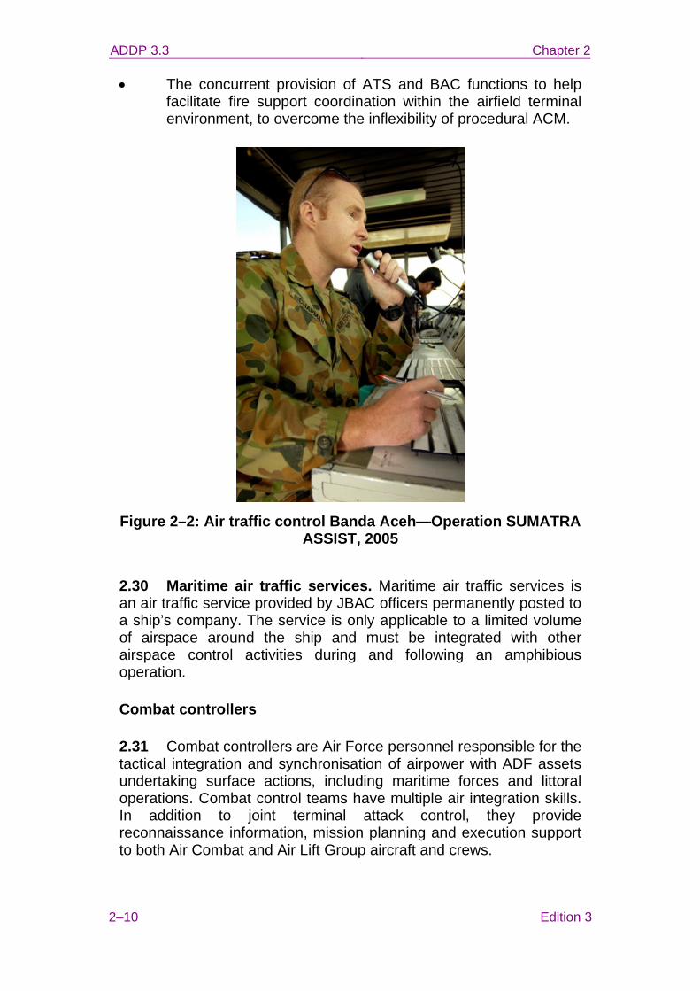
• The provision of International Civil Aviation Organisation (ICAO) compliant ATS with or without surveillance systems (see figure 2–2).
ADDP 3.3 Chapter 2
2–10 Edition 3
• The concurrent provision of ATS and BAC functions to help facilitate fire support coordination within the airfield terminal environment, to overcome the inflexibility of procedural ACM.
Figure 2–2: Air traffic control Banda Aceh—Operation SUMATRA
ASSIST, 2005
2.30 Maritime air traffic services. Maritime air traffic services is an air traffic service provided by JBAC officers permanently posted to a ship’s company. The service is only applicable to a limited volume of airspace around the ship and must be integrated with other airspace control activities during and following an amphibious operation.
Combat controllers
2.31 Combat controllers are Air Force personnel responsible for the tactical integration and synchronisation of airpower with ADF assets undertaking surface actions, including maritime forces and littoral operations. Combat control teams have multiple air integration skills. In addition to joint terminal attack control, they provide reconnaissance information, mission planning and execution support to both Air Combat and Air Lift Group aircraft and crews.
ADDP 3.3 Chapter 2
Edition 3 2–11
Joint terminal attack controller
2.32 A joint terminal attack controller (JTAC) is a qualified (certified) Service member who, from a forward position, directs the action of combat aircraft engaged in close air support and other offensive air support activities. A JTAC has successfully completed the ADF JTAC course.
2.33 If a JTAC is also a qualified JBAC they may provide limited DABATS and BAC in a volume of airspace in an objective area necessary to coordinate the actions of multiple air users, ground manoeuvre and surface-to-surface fire support elements. Figure 2–3 depicts JTAC activity.
2.34 Combat controllers typically perform JTAC duties as a secondary function.
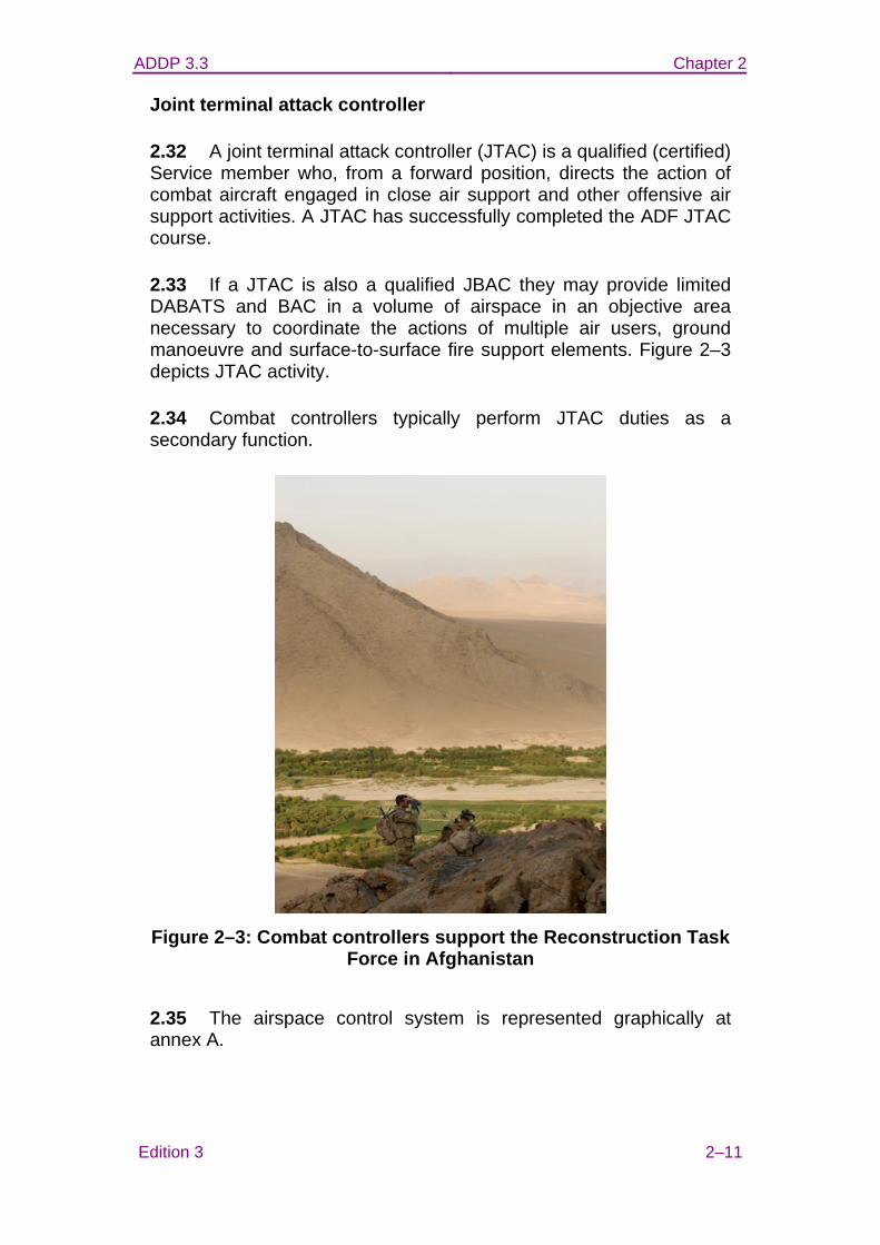
Figure 2–3: Combat controllers support the Reconstruction Task
Force in Afghanistan
2.35 The airspace control system is represented graphically at annex A.
ADDP 3.3 Chapter 2
2–12 Edition 3
COMMUNICATION AND INFORMATION SYSTEMS
2.36 For airspace management and control agencies to effectively support operations, they must have real time information available, and be able to disseminate orders and instructions in a timely manner to all users. Communication and information systems (CIS) should therefore facilitate the timely flow of information to wherever airspace control activities take place.
2.37 The degree of real time flexibility available to airspace users will depend upon the congestion of the airspace and the capabilities of the airspace control agencies to detect, deconflict and integrate the airspace users. The availability of real time communication between all airspace users and the relevant tactical airspace control agency (such as the CRC or ACE) is key to the safe, efficient and flexible use of airspace. Airspace users without real time communications with the airspace control agency may be limited to operating within static, segregated airspace volumes, which limits efficiency and flexibility of all airspace users in a congested airspace environment.
2.38 Key characteristics. For CIS to effectively facilitate the flow of information, the systems should have the following key characteristics:
• constant connectivity with suitable bandwidth and update rate;
• interoperable (preferably common) systems with specific provision for varying levels of information security;
• redundancy; and
• interoperable (preferably common) voice reporting procedures.
Collaborative planning and execution tools
2.39 There are many software tools and applications designed to assist in mission planning and execution that are available and in use throughout the ADF and with coalition partners. To use time and capital resources effectively in the achievement of mission outcomes, these tools should be designed and employed in a way that enables interoperable, if not common, inputs, processes and outputs.
2.40 The theatre battle management core system (TBMCS) is used for the planning, tasking and controlling of all air operations. TBMCS
ADDP 3.3 Chapter 2
Edition 3 2–13
is a joint operational to tactical unit level C2 system that uses integrated, core software systems that reside on the Defence Secret Network. Effective conduct of airspace control relies heavily on TBMCS, and all airspace users should be able to interact with the system. The ACO is produced on and distributed by TBMCS as well as normal command and control processes. At the tactical end the Joint Automated Deep Operations Coordination System provides dynamic monitoring of ACM as they are generated to meet the tactical requirements.
Communication systems
2.41 Communications for airspace control will use a range of means from enciphered or plain voice, to tactical data links or internet protocol over the range of bearers as follows:
• ultra high frequency;
• very high frequency (VHF);
• high frequency (HF);
• satellite communications; and
• fixed and mobile telephone.
2.42 Military communications are normally secure. For compliance with ICAO conventions, the VHF-AM band is operated without frequency-hop and in a non-secure mode.
Refer to ADDP 6.0—Communication and Information Systems for further guidance.
SENSORS
2.43 Airspace control outcomes can be enhanced through shared situational awareness if the current position and identification of all airspace users are readily available to airspace control agencies. Surveillance of the airspace volume and subsequent identification of users is therefore a highly desirable element of the airspace control system.
2.44 The outputs of sensors associated with airspace control should be integrated to provide the best possible information to relevant airspace users and agencies. Data from specific, non-
ADDP 3.3 Chapter 2
2–14 Edition 3
airspace control, tactical level sensors and systems can be integrated into the airspace control system to enhance operational effectiveness.
2.45 To facilitate timely and accurate identification of air assets (to prevent fratricide and/or engagement of non-hostiles) it is essential to have sensor systems that enable standardised identification procedures. The sensors and procedures used will depend on the nature of the operation and force composition.
2.46 The following sensors are available for use in surveillance and identification activities:
• radars, including:
− airborne early warning and control radars;
− surface based microwave (military and civilian) radars;
− secondary surveillance radars (see figure 2–4);
− over the horizon and surface wave HF radars; and
− weapon system radars;
• satellite based sensors;
• visual observations;
• electro-optical devices;
• electro-acoustic sensors; and
• other sensors, such as:
− automatic dependant surveillance—broadcast; and
− automatic dependant surveillance—contact.
ADDP 3.3 Chapter 2
Edition 3 2–15
Figure 2–4: Secondary surveillance radar
2.47 Procedural control. In the absence of sensor coverage, JBAC and ABM are able to facilitate the procedural deconfliction and integration of airspace users. For example, the deconfliction of indirect fire support and/or remotely piloted aircraft from other airspace users may be achieved without reliance upon sensors.
AIRSPACE USERS
2.48 Airspace users have their own characteristics and requirements, which must be taken into account when planning and conducting airspace control activities. Airspace users can be grouped according to role and/or capability as shown in the following indicative list:
• command and control;
• control of the air;
• strike;
• air mobility;
• intelligence, surveillance and reconnaissance;
• joint fires;
ADDP 3.3 Chapter 2
2–16 Edition 3
• amphibious operations;
• special operations;
• maritime anti-air warfare;
• ground based air defence;
• strategic attack—medium to long range surface and subsurface launched systems;
• rotary-wing transport;
• electronic warfare;
• unmanned aerial systems;
• air mobility; and
• civilian aviation.
2.49 The factors associated with airspace users may include the following:
• origin, transit route and destination/target;
• operational performance capabilities and limitations;
• volume and/or dimensions of airspace required;
• time required in airspace;
• possible changes to airspace requirements;
• period of notice of airspace requirements available to agencies;
• deconfliction/integration with other users;
• non-military; and
• security issues.
ADDP 3.3 Chapter 2
Edition 3 2–17
HISTORICAL EXAMPLE—OPERATION DELUGE, SECURITY FOR
ASIA PACIFIC ECONOMIC COOPERATION 2007, ECONOMIC LEADERS WEEK
Planning for airspace control, and operating an airspace control system, are evident in military operations other than war, such as airspace security operations. Airspace security arrangements have been implemented for numerous major events in Australia including during Operation DELUGE—the ADF support to the Asia Pacific Economic Cooperation 2007, Economic Leaders Week in Sydney.
During the period 30 August to 9 September 2007, the ADF airspace control element of Operation DELUGE included supplementing radar surveillance, providing defensive counter air coverage using maritime air defence missiles and F/A-18A aircraft, and supporting civilian police and ADF rotary-wing assets. This was integrated with more than 16 000 civilian aircraft operating in and around Sydney.
The AOC effected the coordination between ADF ABM, ATC and flying units, and civilian ATC to establish and implement the airspace control system for Operation DELUGE through the Eastern ROC at RAAF Base Williamtown. The airspace control system accommodated rules of engagement; operations security; procedures for transition from non-combat to combat; and complex command, control and communications procedures from sensor-to-shooter via the commander. It did this without significant disruption to civilian aviation. The airspace control system demanded integration and close coordination between ABM and ATC, compliance with civilian aviation rules during normal situations, and the ability to rapidly implement decisive air power including lethal force if required. These outcomes were enabled by an integrated and robust communication and information system.
A temporary restricted area (TRA) was established around Sydney. A smaller high density airspace control zone (HIDACZ) was established within the TRA around the key Economic Leaders Week meeting locations. All civilian aircraft were required to obtain prior approval to operate within the TRA, and only essential traffic was permitted within the HIDACZ. In order to minimise the risk of collateral damage or fratricide, the airspace procedures ensured all air traffic was known to the airspace control agencies; this achieved a similar effect to having the civilian aircraft included on an air tasking order. The ADF regulated civilian traffic volumes in key areas at key times, depending on the Economic Leaders Week schedule and prevailing security situation, to ensure an appropriate response would be achieved if a contingency occurred. The ADF also established procedures to close

ADDP 3.3 Chapter 2
2–18 Edition 3
Sydney airspace if that was required to maintain safety and security. Fortunately, such action was not required.
Establishing safe and efficient airspace volumes and procedures was critical to ensuring security was provided to Economic Leaders Week delegates, and to ensuring the ADF activities integrated with Australia’s busiest civilian airspace. Without an effective airspace control system, the ADF would have failed its mission to provide security to the Economic Leaders Week or created adverse economic conditions through disruption to civilian air traffic. Clearly, disrupting Sydney’s economy was unacceptable, particularly given that Operation DELUGE was in support of one of the world’s major economic fora.
Annex: A. The airspace control system
ADDP 3.3 ANNEX A TO
CHAPTER 2
Edition 3 2A–1
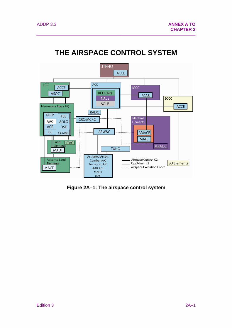
THE AIRSPACE CONTROL SYSTEM
Figure 2A–1: The airspace control system
ADDP 3.3 Chapter 3
Edition 3 3–1
CHAPTER 3
PLANNING
Executive Summary
• The principal products of airspace planning are the airspace control directive (ACD) and airspace control plan (ACP).
• The Headquarters Joint Operations Command (HQJOC) Air and Space Operations Centre (AOC) develops the ACP in parallel with the commander’s overall operation plan.
• The ACP is ratified and issued by the commander joint task force (CJTF).
Introduction
3.1 Airspace control and airspace management are required to effectively use the air domain and allow commanders maximum freedom of action. Effective airspace control requires detailed planning to allow the desired degree of freedom of action. In some campaigns and operations the peacetime airspace control rules and organisational structures may apply, but these rules and organisations will need to change as the level of conflict increases. Moreover, airspace control procedures and organisational structures may differ between joint force areas of operation (JFAOs).
3.2 A CJTF should have an ACP that is dynamic and continually updated as the operation evolves. The ACP should provide simple and easy to follow instructions and account for the needs and priorities of all airspace users.
3.3 The joint military appreciation process (JMAP) is used to develop the overall operational plan and from this the air plan and the airspace control planning products; specifically, the ACD and the ACP are developed. The development of the ACD and ACP will usually be managed and coordinated by the airspace planning staff in accordance with the Airspace Control Authority’s (ACA’s) direction and guidance. The airspace plans staff require input from all joint task force (JTF) elements that need access to the airspace, to ensure that

ADDP 3.3 Chapter 3
3–2 Edition 3
the ACP supports the commander’s intent, mission objectives and desired effects.
PLANNING PRODUCTS
3.4 Joint Air Operations Guide. The AOC promulgates the Joint Air Operations Guide (JAOG), which articulates the CJTF’s intent. The JAOG establishes the commander’s priorities and allocates resources from which operational tasking is developed.
3.5 Airspace control directive. The ACD is the first product of the airspace planning process and is issued by the Chief of Joint Operations to a CJTF or other subordinate commander. The ACD articulates:
• the ACA;
• higher level guidance on airspace management;
• the airspace control organisation;
• the airspace control area;
• all applicable agreements regarding airspace control;
• airspace management constraints or restraints placed on CJTF; and
• relationships between airspace control agencies and, if necessary, any changes to command and control (C2) arrangements between them, and the authority for that change.
3.6 An indicative ACD template is at annex A.
3.7 Airspace control plan. The ACP defines the airspace and airspace procedures and has the authority of an order when approved by the CJTF. The ACP is drafted by the AOC airspace planning staff on behalf of the ACA. The ACP is released as an annex to the Joint Air Operations Guide. An indicative ACP template is at annex B.
ADDP 3.3 Chapter 3
Edition 3 3–3
PLANNING PROCESS
Establish airspace control requirements
3.8 Operational priorities. Phasing of the campaign or operation, from build-up to re-deployment, and specific high priority missions, must be reflected in the ACP. Priority for airspace use by mission and/or airspace user type(s) should also be determined. Procedures should facilitate switching of airspace priorities dictated by the CJTF, component commanders and the operational situation within the JFAO.
3.9 Type and degree of airspace control. The JFAO may be suitable for zoning with various degrees of airspace control being applied in each zone. Where rigid control is not required, undue restrictions should be avoided rather than simply maintaining a single type or degree of airspace control throughout the JFAO. The ACA should determine to what extent airspace control is necessary over hostile territory. This should include the airspace requirements for maritime task force operations and the conduct of expeditionary or amphibious operations.
3.10 Airspace control is commonly required even in the absence of desired communication, navigation and surveillance systems. Procedures for degraded operations should be included within the ACP. Specifically, the airspace control system should not rely exclusively upon positive control using electronic surveillance systems.
3.11 Command and control, communications, computers and intelligence (C4I) structure. A C4I structure supports the airspace control system and enables implementation of the ACP. When establishing this structure it is necessary to review:
• relative locations of the JTF headquarters (HQ), component HQ, major force elements and, where appropriate, host nation HQ;
• interfaces with the communication and information systems (CIS) throughout the force, its coalition partners and, if required, the host nation;
• host nation support/restrictions;
• interface with all airspace control agencies, including the air
ADDP 3.3 Chapter 3
3–4 Edition 3
battle management (ABM) systems; and
• interface with civil and military air traffic control (ATC).
3.12 Staffing. Airspace control agencies are identified during planning and promulgated in the ACP. The ACP will also specify the requirements for personnel to be placed in host nation ATC centres, or other operational level headquarters in order to facilitate better airspace coordination and information flow.
3.13 Establish process for airspace activation, allocation, resumption and deactivation. The ACP will articulate the process, responsibilities and coordination protocols associated with the transition of the airspace from its normal state to combat airspace and return. This should include procedures for allocation and resumption of airspace volumes. The integration and coordination of non-permanent airspace control agencies (such as airborne early warning and control) into the wider airspace control system requires careful planning to ensure division of responsibilities across airspace agencies is clearly specified.
3.14 Navigation, height and time references. The ACP should clearly stipulate the geodetic, height and time datum in use. Pressure setting(s) for height datum and the responsibility for updating the pressure settings will be established.
3.15 Airspace control agency requirements. The requirements of all airspace control agencies should be considered. The following are typical:
• procedures to be used,
• traffic priorities,
• airspace boundaries,
• coordination between neighbouring airspace areas,
• reporting requirements,
• CIS requirements,
• operations security, and
• regulatory compliance.
ADDP 3.3 Chapter 3
Edition 3 3–5
Establish capability requirements
3.16 Airspace control assets. Airspace control assets should be configured to conduct and achieve mission objectives and mission support requirements. Asset capabilities, interoperability, and potential availability and limitations should be considered when planning the integration of the various airspace control assets and sensors. Potential assets include:
• airfield systems and associated personnel;
• static and mobile ABM, battlefield airspace control and air traffic services facilities (see figure 3–1);
• airborne early warning and control aircraft;
• maritime surveillance systems, ABM, Amphibious Airspace Coordination Element and maritime air traffic services; and
• ground based air defence (GBAD) sensors.
Figure 3–1: ADF personnel staffing Baghdad International Airport Tower—Operation CATALYST, Nov 2003
3.17 Deployment of assets. The deployment of airspace control assets into the JFAO should be prioritised. This determines how airspace control is to be conducted during the build up to the mature airspace control system. Command and control, logistic support and
ADDP 3.3 Chapter 3
3–6 Edition 3
personnel, and recovery/hand-over/redeployment options, including emergency withdrawal, should also be identified.
Establish communication and information system requirements
3.18 In planning the deployment and use of information networks utilised in airspace control activities, the following considerations should be taken into account:
• Systems interoperability. While deployed forces normally operate the same CIS backbone, the bearers and software tools invariably differ. The interoperability specifications required to support the range of airspace control requirements needs to be considered early to minimise risk.
• Frequency management. In order to ensure that communication systems can operate without interference and with the desired fidelity and security, a frequency management plan should be prepared for operations/exercises within Australia. When an operation is to be conducted in a location outside of Australia’s area of frequency management jurisdiction, the plan should be prepared with the cooperation of the host nation, other assisting parties or coalition partners. Careful spectrum management is required to mitigate the potential effects of emitters on the integrity of tactical digital information links and CIS networks.
Establish rules and procedures
3.19 Airspace control means. Airspace control means (ACM) are developed according to types and requirements of airspace users within the overall plan. Aircraft and weapon system characteristics may have an effect on ACM parameters. Guidance on employment of ACM can be found in chapter 4—‘Execution’.
3.20 Airspace allocation and prioritisation. Guidance should be provided through the ACP to airspace control agencies regarding the allocation and prioritisation of airspace to potential users.
3.21 Fire support coordination measures (FSCM). FSCM are employed by maritime, land, air and special operations force element commanders to enable rapid engagement of targets while providing safeguards for friendly forces. FSCM are employed according to the operational situation through the operational chain of command.
ADDP 3.3 Chapter 3
Edition 3 3–7
3.22 Identification (ID). ID procedures and authority should be established. ID procedures are established to identify own forces and adversaries and to avoid fratricide. Standing ID guidance is provided by the Joint Interface Control Officer in HQJOC.
Establish timelines
3.23 The ACP should be developed and promulgated in concert with the JTF operation order or operation instruction. The timely preparation and release of the ACP is crucial to efficient planning at lower levels of the organisation, including longer term logistic, deployment and redeployment planning, as well as shorter term planning.
Risk management
3.24 Risk management principles should be applied to the development of the ACP. While each task unit and task element should prepare their own risk management plan, it is the obligation of higher level agencies to understand and pre-empt known problems, and provide solutions in the ACP.
Airspace control planning factors
3.25 An aide-memoire of planning factors for airspace control planning is detailed at annex C.
AIRSPACE USER PLANNING CONSIDERATIONS
3.26 Airspace should not be unnecessarily segmented by arbitrary lateral or vertical boundaries, particularly in circumstances where an organic airspace control agency has the capability to control all airspace within a designated JFAO.
3.27 Airspace planning must consider the airspace environment both inside and adjacent to the JFAO and must integrate the military airspace control system with the surrounding, overlapping, airspace control environment. Civilian airspace users will be notified of relevant airspace control arrangements through unclassified means such as notices to airmen or aeronautical information publications.
Maritime operations
3.28 Maritime operations are intrinsically multi-domain and invariably joint, employing organic and non-organic air assets for
ADDP 3.3 Chapter 3
3–8 Edition 3
surveillance, reconnaissance, force defence, force projection and resupply. Maritime force elements require potentially large operating areas that may extend considerable distances inland. They may change location, expand, contract and change shape as maritime elements manoeuvre.
3.29 Within these operating areas there are normally small numbers of high value assets which are difficult to conceal. This places a premium on effective defence against all types of weaponry, which may approach from any direction.
3.30 These factors demand highly responsive and flexible airspace control, usually based on positive control procedures, optimised for force protection. This has led to distinctive maritime procedures and terminologies, which are also used by allied navies. In this environment the Maritime Region Air Defence Commander (MRADC) has responsibility for airspace control. The region will normally be defined as a range from the force’s mean line of advance and may be limited to the shoreline where a regional air defence commander controls the bordering region.
3.31 In littoral operations, specific control and defensive measures may be a composite of measures employed in individual domains. Increasingly, maritime assets have the ability to influence both air defence and strike operations over both land and sea.
Land operations
3.32 Land assets that require airspace may include aircraft, offensive support systems, guided weapons, unmanned aerial systems (UAS) and GBAD. These systems require airspace with minimum practicable restriction to achieve the desired effects. An offensive support system is shown in figure 3–2.
ADDP 3.3 Chapter 3
Edition 3 3–9
Figure 3–2: Artillery providing offensive support
3.33 Flexible and robust airspace control procedures are required for the close battle to maximise the air support available to ground forces while allowing ground commanders maximum freedom of manoeuvre to employ forces.
Air operations
3.34 The ranges of modern air weapon systems, their associated engagement profiles and evasion tactics necessitate the control and management of large volumes of airspace. While modern aircraft have good navigation equipment and comprehensive communications suites, aircrew in combat have little time for complex procedures or multiple controlling agencies.
3.35 The Regional Operations Centre (ROC) can integrate the activities of a variety of airspace users and provide real time airspace management and control. In undertaking tactical coordination and direction on behalf of the ACA, the ROC will undertake liaison (both laterally and vertically), provide specialist advice, and control military aircraft to facilitate the safe and effective use of operational airspace. An example Mobile Control and Reporting Centre, based at Kandahar Airfield, Afghanistan is shown in figure 3–3.
ADDP 3.3 Chapter 3
3–10 Edition 3
Figure 3–3: Mobile Control and Reporting Centre cabin, based at
Kandahar Airfield, Afghanistan
Special operations
3.36 Special operations forces require airspace for insertion, extraction, joint fire support and intelligence, surveillance and reconnaissance. They may also have organic air assets with unique planning requirements. Special operations forces have sophisticated communications. Close liaison is required between mission planners and the AOC to avoid mutual interference and fratricide, and to ensure that airspace planning does not compromise operations security. Figure 3–4 depicts members of the Special Operations Task Group preparing for insertion by helicopter.
ADDP 3.3 Chapter 3
Edition 3 3–11
Figure 3–4: Special Operations Task Group personnel preparing for insertion by helicopter, Afghanistan, Oct 2009
Amphibious operations
3.37 The purpose of amphibious operations is to tactically project the land force ashore, in an environment ranging from permissive to hostile. Amphibious operations may be conducted within an amphibious objective area (AOA) or more dynamically as part of a ship to objective manoeuvre. An AOA must be large enough for all the maritime, land and air operations required to lodge the required land forces ashore.
3.38 For amphibious operations the commander may be designated as a subordinate airspace control authority (SACA) for the AOA. This designation is only for the duration of the amphibious lodgement. Designating the Commander Amphibious Task Force (CATF) in this role is required to ensure that all air operations and airspace control procedures within the AOA are centrally controlled. If the CATF is designated as a SACA, the force must have the ability and assets to exercise the desired degree of airspace control and management.
3.39 The location and size of an AOA may have considerable effect on (and implications for) the ACP. The airspace associated with an AOA is effectively a high-density airspace control zone. The impact on other operational activities and airspace control structures can be

ADDP 3.3 Chapter 3
3–12 Edition 3
problematic and require coordination at a JTF command level. Tasking and procedures for air activities within the AOA must be as flexible as possible, particularly noting the presence and operational role of the MRADC for force air defence.
3.40 The transition to land based C2 following dissolution of the AOA needs to be planned. On completion of the amphibious operation, a tactical area of responsibility is established in place of the AOA. Responsibility for airspace control transfers from the CATF to the previously nominated ACA.
Refer to Australian Defence Doctrine Publication 3.2—Amphibious Operations for further guidance.
Unmanned aerial systems
3.41 The airspace control system must be able to communicate with the UAS ground control element, which may be outside the JFAO. Tactical UAS may be employed by manoeuvre elements that have limited situational awareness of the airspace.
3.42 The airspace control system must accommodate variations in UAS ability to comply with instructions and conform to airspace boundaries, and to sense and avoid other airspace users. The less a UAS can comply/conform/sense and avoid, the more the airspace control system must control the integration of the UAS activity. Restricted operating zones for the launch and recovery of remotely piloted aircraft, transit corridors and operating areas are sound solutions; however these can often interfere with other airspace activities and undermine the commander’s flexibility to employ the UAS where and when required. Airspace control procedures for UAS are detailed in chapter 6—‘Control and Coordination Procedures’.
Joint fires areas
3.43 A joint fires area (JFA) is a three-dimensional permissive FSCM used by CJTF and subordinate component commanders to facilitate rapid engagement of targets by air-to-surface, surface-to-surface and subsurface-to-surface weapons to achieve lethal and/or non-lethal effects. The purpose of a JFA is to integrate joint fire support and achieve effects in support of the scheme of manoeuvre. Established JFAs are promulgated on the airspace control order. Aircraft may be tasked to a JFA by the air tasking order or redirected to a JFA by a tactical C2 agency such as a control and reporting unit.
ADDP 3.3 Chapter 3
Edition 3 3–13
3.44 JFA description and procedures are contained in chapter 5—‘Airspace Control Means’.
Annexes: A. Airspace control directive template B. Airspace control plan template C. Airspace control planning factors aide-memoire
ADDP 3.3 ANNEX A TO
CHAPTER 3
Edition 3 3A–1
AIRSPACE CONTROL DIRECTIVE TEMPLATE
File reference
See distribution
CHIEF OF JOINT OPERATIONS
AIRSPACE CONTROL DIRECTIVE
TO
COMMANDER JOINT TASK FORCE XXX
(OPERATION/EXERCISE NAME)
Introduction
1. The introduction of the airspace control directive (ACD) should clearly describe the situation that led to the need for the ACD; for example, a natural disaster, or political or military upheaval. This section may also detail actions being taken by Australia to resolve the situation, including any defined operational objectives and end states. Adversary and friendly forces may be detailed if appropriate. Issues to be addressed in the introduction may include:
a. authorities or mandates—for example any United Nations resolutions;
b. the status of host nation airspace control agencies;
c. any agreements or memorandums that may exist—for example with the host nation or the host nation airspace control agency; and
ADDP 3.3
3A–2 Edition 3
d. any Australian Government direction or constraints in regard to airspace control.
Airspace control authority
2. This section should appoint the airspace control authority (ACA).
Airspace control area
3. This section should define the airspace control area for the exercise/operation. For example, the airspace control area for Operation XXXXX is the entire airspace within the Operation XXXXX joint force area of operations (JFAO).
Airspace control plan
4. If an airspace control plan (ACP) is required, this section should direct the ACA to produce that plan. References for the format of the ACP may be provided.
5. For example, the joint task force (JTF) commander is to issue an ACP that incorporates detailed airspace control measures and airspace procedures.
Airspace operations
6. This section should provide any specific guidance to the ACA on how to conduct airspace operations. Issues detailed here could include:
a. Any specific constraints or restraints.
b. Any international or host nation agencies with which the JTF commander must coordinate airspace control activities.
c. The method of assumption of airspace control responsibilities, for example:
(1) you are to assume airspace control authority with the assistance and consent of the host nation government as detailed in memorandum of agreement (title and date); or

ADDP 3.3
Edition 3 3A–3
(2) you are to assume airspace control authority with or without the consent or assistance of the government of X.
d. Specific guidance in regard to the structure and/or operation of the airspace control system, for example:
(1) you are not to impede the normal flow of regular public transport;
(2) you are to exercise control of all air traffic within your airspace control area; and/or
(3) where the achievement of operational objectives will not be compromised, the safe passage of civilian air traffic should be allowed.
e. The specific airspace control assets available to effect the airspace control within the JFAO.
f. Details of any dormant authorities or guidance, which may be triggered by specific events. For example, in the event of a hostile act by nation Z, you are to assume full airspace authority within the airspace control area (airspace of nation Y) and allow civil air operations at your discretion.
g. The need for integrated airspace and counter air activities to prevent fratricide.
h. Specific guidance in regard to the establishment of airspace boundaries within the airspace control area.
i. Specific guidance in regard to the establishment of an air defence identification zone(s).
j. Specific guidance in regard to any sovereign and/or international airspace within the airspace control area.
k. Any airspace management arrangements in regard to the issue of notice to airmen.
ADDP 3.3
3A–4 Edition 3
l. Details of how and when airspace authority is to be returned to civil agencies following the cessation of military operations/emergency.
Reports and returns
7. This section details any reports and returns required by the Chief of Joint Operations in regard to airspace control.
ADDP 3.3 ANNEX B TO
CHAPTER 3
Edition 3 3B–1
AIRSPACE CONTROL PLAN TEMPLATE
File reference
See distribution
OPERATION (EXERCISE) XXXXX
AIRSPACE CONTROL PLAN
References: (maps, charts, relevant documents as required) Time Zone: Time zones used throughout this plan: ZULU
Situation
1. The situation paragraph provides all airspace users with a common understanding of the current and projected situation. It provides the operational context for the airspace control plan (ACP) that follows.
a. Adversary. This sub-paragraph should give clear but brief guidance as to the adversary’s air capabilities, vulnerabilities and intentions.
b. Friendly. This sub-paragraph should give a clear but brief description of friendly air capabilities, vulnerabilities and intentions.
General
2. Purpose. The purpose of this ACP is to define the airspace and airspace management procedures to be employed during Operation XXXXX/Exercise XXXXX .
3. Higher intent. This ACP includes guidance and directives issued by the Chief of Joint Operations in the airspace control directive and any other relevant higher guidance.

ADDP 3.3
3B–2 Edition 3
4. Authority for issue. This ACP is issued under the authority of the airspace control authority (ACA).
5. Applicability. The procedures detailed in this ACP will apply to all friendly aircraft transiting to or from, or operating within, the lateral and vertical limits of the ACA. This ACP should be read in conjunction with the air defence plan.
6. Validity. This ACP is valid for the period (time (Z) month/year) to (time (Z) month/year) unless cancelled or amended.
7. Amendment. The authority for amendment of this ACP will be airspace control orders (ACOs) issued by the ACA.
8. Timings. All timings in this ACP are in universal time coordinate.
9. Geodetic datum. All positions/maps/charts are to be based on the World Geodetic System 1984 (WGS84) datum.
10. Area reference system. In circumstances where an area reference system is appropriate, the ACP shall specify that the Global Area Reference System is to be used, unless the joint task force commander determines that, for operational reasons, another system is to be used. In such a case, the ACP shall describe the theatre-specific area reference system.
11. Safety. The procedures in this document should not be over-ride the principles of due regard, whereby military aircraft shall conduct operations and activities with due regard for the safety of civilian aircraft that may be affected. The procedures are intended to add an additional safety barrier and increase the situational awareness of all airspace users while maintaining as much flexibility as possible.
12. Integration with civilian air traffic control. Integration with civilian/host nation air traffic control (ATC) services will be in accordance with the ADF/Airservices Australia (AsA)/host nation authority memorandum of agreement (MOA) at reference A.
13. Enquiries and changes. Questions on the management of airspace during Operation XXXXX/Exercise XXXXX or changes required to this ACP before the start of the exercise should be referred to the ACA or joint airspace control cell (JACC) within the Headquarters Joint Operations Command Air and Space Operations Centre (AOC) (include email or message address).
ADDP 3.3
Edition 3 3B–3
14. Briefings. Mandatory aircrew/controller briefings will be held at a specified time and location.
Airspace structure
15. Airspace control area. The airspace control area for Operation XXXXX/Exercise XXXXX has been established in accordance with the ADF/AsA/host nation authority MOA at reference B.
16. Airspace layout is best displayed in an annex as a diagram that includes:
a. lateral limits;
b. altitudes;
c. duration (should be included in main document text as well as the annex diagram); and
d. coordinating altitude (CA).
17. Special use airspace. Within the airspace control area, the following special use airspace is established:
a. designated tactical areas of operation (AO);
b. air traffic zones (ATZ);
c. air-to-air refuelling (AAR) and airborne early warning and control areas;
d. environmental protection areas;
e. amphibious objective area; and
f. airspace control means (ACM) (see later section on airspace activation/deactivation).
Command and control
18. Airspace control authority. The joint force commander has appointed…..as the ACA for Operation XXXXX/Exercise XXXXX. The ACA will be located with…..headquarters…..at…..(location)…..and
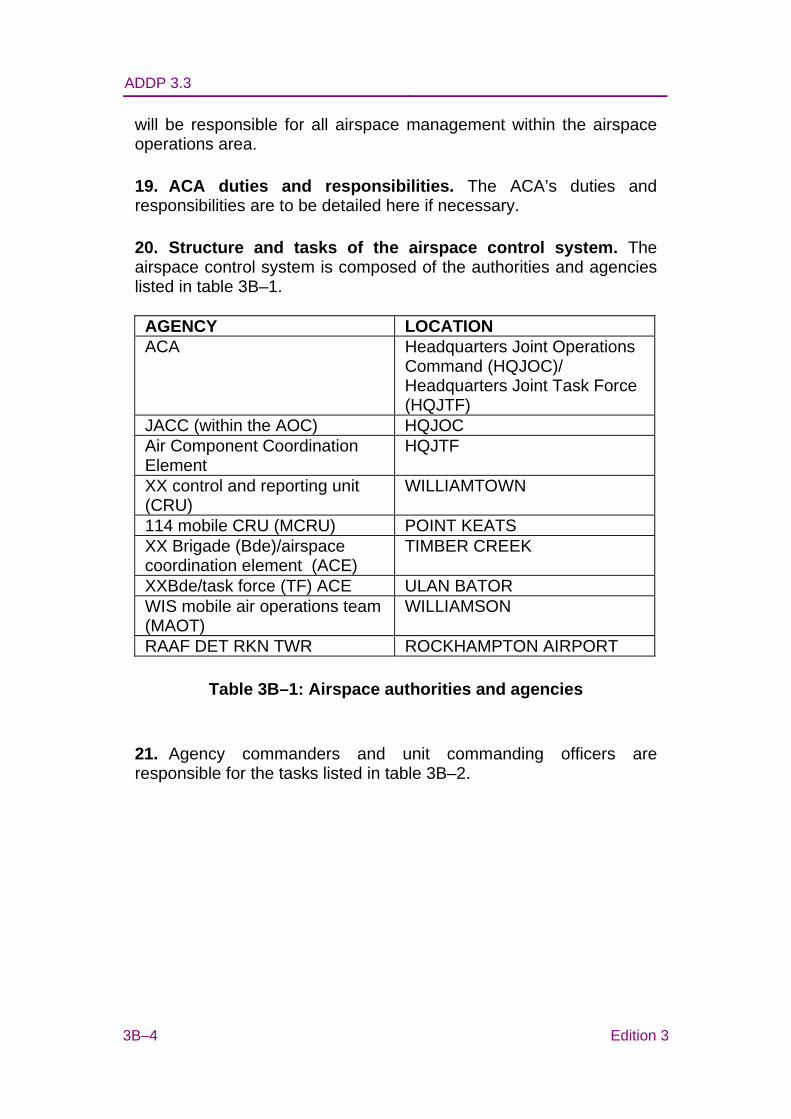
ADDP 3.3
3B–4 Edition 3
will be responsible for all airspace management within the airspace operations area.
19. ACA duties and responsibilities. The ACA’s duties and responsibilities are to be detailed here if necessary.
20. Structure and tasks of the airspace control system. The airspace control system is composed of the authorities and agencies listed in table 3B–1.
AGENCY LOCATION ACA Headquarters Joint Operations
Command (HQJOC)/ Headquarters Joint Task Force (HQJTF)
JACC (within the AOC) HQJOC Air Component Coordination Element
HQJTF
XX control and reporting unit (CRU)
WILLIAMTOWN
114 mobile CRU (MCRU) POINT KEATS XX Brigade (Bde)/airspace coordination element (ACE)
TIMBER CREEK
XXBde/task force (TF) ACE ULAN BATOR WIS mobile air operations team (MAOT)
WILLIAMSON
RAAF DET RKN TWR ROCKHAMPTON AIRPORT
Table 3B–1: Airspace authorities and agencies
21. Agency commanders and unit commanding officers are responsible for the tasks listed in table 3B–2.
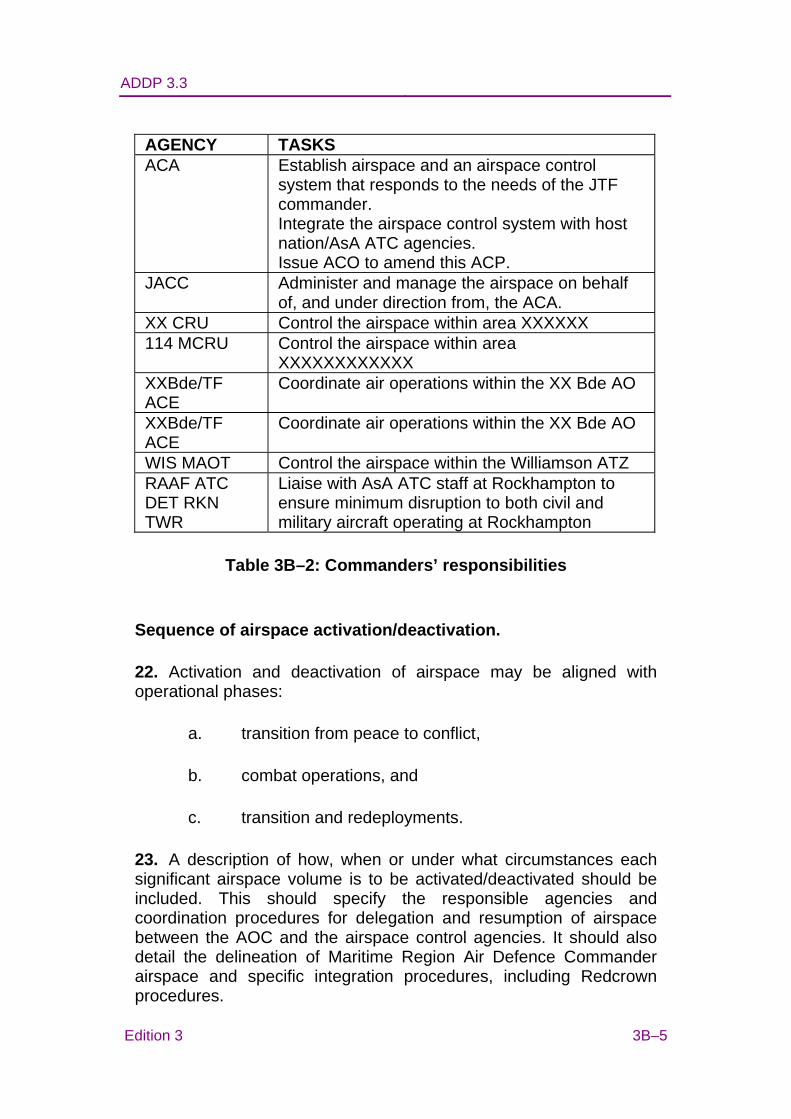
ADDP 3.3
Edition 3 3B–5
AGENCY TASKS ACA Establish airspace and an airspace control
system that responds to the needs of the JTF commander. Integrate the airspace control system with host nation/AsA ATC agencies. Issue ACO to amend this ACP.
JACC
Administer and manage the airspace on behalf of, and under direction from, the ACA.
XX CRU Control the airspace within area XXXXXX 114 MCRU Control the airspace within area
XXXXXXXXXXXX XXBde/TF ACE
Coordinate air operations within the XX Bde AO
XXBde/TF ACE
Coordinate air operations within the XX Bde AO
WIS MAOT Control the airspace within the Williamson ATZ RAAF ATC DET RKN TWR
Liaise with AsA ATC staff at Rockhampton to ensure minimum disruption to both civil and military aircraft operating at Rockhampton
Table 3B–2: Commanders’ responsibilities
Sequence of airspace activation/deactivation.
22. Activation and deactivation of airspace may be aligned with operational phases:
a. transition from peace to conflict,
b. combat operations, and
c. transition and redeployments.
23. A description of how, when or under what circumstances each significant airspace volume is to be activated/deactivated should be included. This should specify the responsible agencies and coordination procedures for delegation and resumption of airspace between the AOC and the airspace control agencies. It should also detail the delineation of Maritime Region Air Defence Commander airspace and specific integration procedures, including Redcrown procedures.
ADDP 3.3
3B–6 Edition 3
Aircraft operations
24. All joint aircraft operations within the airspace control area will be tasked by the joint force air component commander in a daily (or other period as specified) air tasking order (ATO) which may be amended by ATO changes.
25. The ACA has set the following airspace priorities by mission and/or user type(s), for example:
a. declared emergency aircraft;
b. control of the air;
c. joint personnel recovery (JPR), including combat search and rescue;
d. aeromedical evacuation;
e. close air support;
f. unmanned aerial system (UAS) operations;
g. air interdiction;
h. strategic attack; and
i. airborne operations.
Airspace management
26. Overview of how airspace will be managed (including range control if applicable).
27. Air traffic control procedures. The following air traffic procedures are to apply during Operation XXXXX/Exercise XXXXX:
a. general:
(1) vertical buffers,
(2) separation responsibilities, and
ADDP 3.3
Edition 3 3B–7
(3) avoidance of built up areas;
b. airspace activation and release procedures;
c. transit to and from the airspace control area:
(1) transit corridors, and
(2) low level operations;
d. entry to and exit from the airspace control area;
e. procedures above the CA:
(1) positive versus procedural control;
(2) visual metrological conditions (VMC); and
(3) instrument metrological conditions (IMC);
f. sanctuary levels (particularly during exercises, when it may be necessary for these to be adhered to throughout);
g. procedures below the CA:
(1) VMC, and
(2) IMC;
h. ATZ procedures;
i. operations within ACM airspace;
j. operations within special use airspace;
k. fire support coordination, including joint fires area procedures;
l. civilian aircraft operating in the joint force area of operations;
m. AAR;
ADDP 3.3
3B–8 Edition 3
n. flight advisory messages and flight plans:
(1) requirements:
(a)when required;
(b)turning and reporting points (lateral and longitudinal reporting points as per relevant documents);
(c)planned via entry and exit points; and
(d)low jet routes may be required;
(2) standard flight plans:
(a)activation; and
(b)corridors, minimum risk routes etc;
o. identification friend or foe (IFF)/selective identification feature procedures:
(1) responsible authority;
(2) promulgation of IFF codes;
(3) IFF procedures (aircraft will squawk all modes as specified in the ATO, unless otherwise directed. Components requiring additional codes or desiring to change codes should forward requests to the ACA);
(4) mode I IFF assignment;
(5) mode II IFF assignment;
(6) mode III IFF assignment;
(7) mode IV IFF assignment; and
(8) mode V IFF assignment.
ADDP 3.3
Edition 3 3B–9
p. navigation aids;
q. altimeter settings;
r. counter air coordination;
s. special procedures (UAS, cruise missiles, etc); and
t. electronic warfare.
28. ACM and the ACO:
a. ACM (refer to standard annex of definitions and dimensions for ACM):
(1) advisory airspace outside controlled airspace; and
(2) pre-planned ACM (details in an annex).
b. ACO:
(1) will detail all activated ACM in full;
(2) include a change summary;
(3) 24 hr cycle (or other period as specified to align with the ATO cycle);
(4) time of issue; and
(5) period covered.
c. Airspace control means request (ACMREQ):
(1) format is to be Australian Message Text Format, and
(2) when required at AOC for promulgation in the next ACO.
29. Emergencies and abnormal operations:
ADDP 3.3
3B–10 Edition 3
a. responsible agencies for aircraft emergencies;
b. cease activities ‘knock it off’ and ‘check-fire’;
c. aircraft emergencies:
(1) aircrew actions;
(2) airspace control agency action;
(3) aircraft communications failures:
(a)single aircraft;
(b)formation aircraft; and
(c)sanctuary altitudes (may be described in ATC procedures).
(4) weapons emergencies:
(a)weapons jettison areas, and
(b)hung bomb routes.
(5) ejection;
(6) fuel dumping; and
(7) diversion airfields and facilities.
d. search and rescue (SAR):
(1) SAR responsibilities, and
(2) reference to JPR plan.
30. Weather details and specific weather criteria.
31. Communications:
a. ATC communications links (annex/diagram);
ADDP 3.3
Edition 3 3B–11
b. all aircraft to monitor emergency frequencies;
c. frequency assignments;
d. reference to the communications plan;
e. degraded ground communications; and
f. degraded air defence ground environment serviceability.
Annexes (as required, for example): A. Airspace layout (diagram or definition) B. Planned airspace control means C. Special air traffic control procedures and air traffic zone
procedures D. Communications (plan or diagram)
ADDP 3.3 ANNEX C TO
CHAPTER 3
Edition 3 3C–1
AIRSPACE CONTROL PLANNING FACTORS AIDE-MEMOIRE
1. The following paragraphs list planning factors, specific to airspace control, which should be considered when developing the airspace control plan.
2. Operational guidance:
a. higher commander’s airspace control directive;
b. joint task force commander’s concept of operations;
c. component commander’s concepts of operations;
d. information operations—disguised (protection) or simulated airspace control patterns;
e. type of operation (warlike or non-warlike);
f. mission, end state, objectives and effects to be achieved;
g. rules of engagement;
h. identification policy and identification authority;
i. duration and complexity;
j. constraints and limitations;
k. operational phasing if appropriate; and
l. planning time available.
3. Own force structure:
ADDP 3.3
3C–2 Edition 3
a. number, type and capability of assets;
b. command and control arrangements and organisational structure;
c. communication and information systems (CIS) infrastructure;
d. any dominant systems, either in or across components;
e. any new systems;
f. any special features (such as Link 16);
g. host and coalition forces;
h. significant equipment shortfalls/vulnerabilities; and
i. own centre of gravity.
4. Threat:
a. adversary’s order of battle;
b. adversary’s centre of gravity;
c. capabilities and intent; and
d. is there a credible air threat?
5. Neutral/non-combatants:
a. protection of neutral/non-combatant aircraft;
b. International Civil Aviation Organisation (ICAO) involvement/applicability;
c. private, United Nations (UN) (or similar agency) and commercial aircraft; and
d. neutral military aircraft.
ADDP 3.3
Edition 3 3C–3
6. Assets with airspace control capabilities:
a. existing theatre airspace control capabilities (CIS/surveillance systems/air traffic control facilities);
b. ability to support planned operations (training/proficiency/will);
c. extent of CIS/compatibility/rate of data transfer;
d. component/coalition forces organic airspace control assets;
e. specialist manpower availability; and
f. sustainability.
7. Host nation agreements, status of forces agreement or mandate:
a. command of in-theatre airspace control and/or air traffic services (ATS);
b. authority of airspace control authority over in-theatre airspace control/ATS assets; and
c. ICAO authority and host nation restrictions.
8. Other agencies:
a. other government departments;
b. UN; and
c. non-government organisations (eg Red Cross/Red Crescent).
9. Geo-strategic:
a. weather and climate, topography, and environment;
b. availability of maps/charts/imagery; and
ADDP 3.3
3C–4 Edition 3
c. geo-reference system to be used.
10. Security:
a. need or not for airspace control to be secure, and security of available airspace control system; and
b. back-up plan and/or system.
11. Legal issues:
a. international and national law, including air law, treaties and conventions;
b. legal staff awareness of the airspace control plan, with a discussion of issues and uncertainties; and
c. law of armed conflict and rules of engagement.
12. Logistics:
a. total requirements for airspace control personnel and equipment;
b. required timelines for deployment, build-up, operations and recovery;
c. priorities for deployment;
d. lines of communication; and
e. sustainability.
13. Training:
a. requirement (if any);
b. time required/available; and
c. facilities required/available.
14. Coalition/host nation personnel.
ADDP 3.3 Chapter 4
Edition 3 4–1
CHAPTER 4
EXECUTION
Executive Summary
• The air tasking cycle is divided into six steps.
• The airspace control order (ACO) is a summary of those control procedures and airspace control means (ACM) required to implement or amend the Airspace Control Plan (ACP) during a specified time period.
• ACM can be requested and authorised dynamically, subject to operational requirements.
Introduction
4.1 Commander Joint Task Force’s (CJTF’s) intent and objectives are achieved through the air tasking cycle, which produces an air battle plan, air tasking order and ACO.
4.2 An ACM is a procedural method of defining a specific portion of airspace for a particular purpose. It can be pre-determined in the ACO or arranged dynamically according to operational requirements.
AIR TASKING CYCLE
4.3 Once air operation planning has been completed and the Joint Air Operations Guide and appropriate orders and instructions have been issued, the air planning and tasking process enters an enduring cyclic phase of operations. The air tasking cycle is the way in which the CJTF’s intent and guidance is effectively and efficiently converted into an executable air battle plan and air tasking orders, which are then executed by air assets. To be effective the air tasking cycle must:
• support the CJTF’s intent and objectives;
• be flexible enough to accommodate changes in the tactical situation or the CJTF’s guidance;
ADDP 3.3 Chapter 4
4–2 Edition 3
• integrate all the component commander’s requirements; and
• be issued in a timely fashion, to facilitate other operational planning and coordination as well as force preparation.
4.4 The joint air tasking cycle is divided into six steps. It begins with the CJTF’s guidance and progresses through the various steps until the missions have been flown and the results assessed, whereupon the cycle begins again (see figure 4–1). The duration of the air tasking cycle is determined by the joint force air component commander (JFACC) and is dependent on the duration of the execution phase, which is the period covered by the air battle plan (ABP).1
4.5 The period of the air tasking cycle is usually considered to be from the start of commander’s guidance to the completion of the execution phase. Operational assessment is not normally included as it is considered to be a continuous and ongoing process which will be conducted throughout all of the other phases including the execution phase. For a 24 hour ABP detailed planning will usually begin 72 hours prior to the commencement of the execution phase resulting in a 96 hour air tasking cycle. Due to the difference between the duration of the ABP and the period of the air tasking cycle, there will normally be three ABP in various stages of planning or execution at any one time.
1 During high tempo operations, the normal ABP validity period is 24 hours. In lower tempo operations the validity period may be extended to seven or more days.
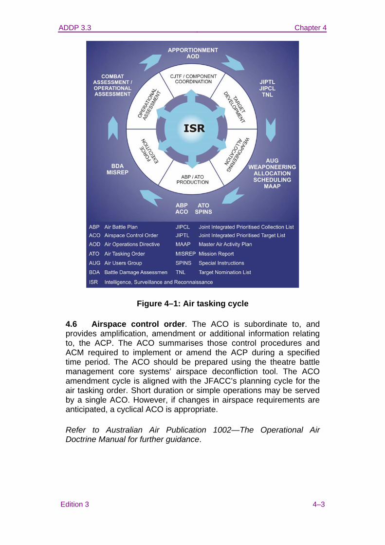
ADDP 3.3 Chapter 4
Edition 3 4–3
Figure 4–1: Air tasking cycle
4.6 Airspace control order. The ACO is subordinate to, and provides amplification, amendment or additional information relating to, the ACP. The ACO summarises those control procedures and ACM required to implement or amend the ACP during a specified time period. The ACO should be prepared using the theatre battle management core systems’ airspace deconfliction tool. The ACO amendment cycle is aligned with the JFACC’s planning cycle for the air tasking order. Short duration or simple operations may be served by a single ACO. However, if changes in airspace requirements are anticipated, a cyclical ACO is appropriate.
Refer to Australian Air Publication 1002—The Operational Air Doctrine Manual for further guidance.
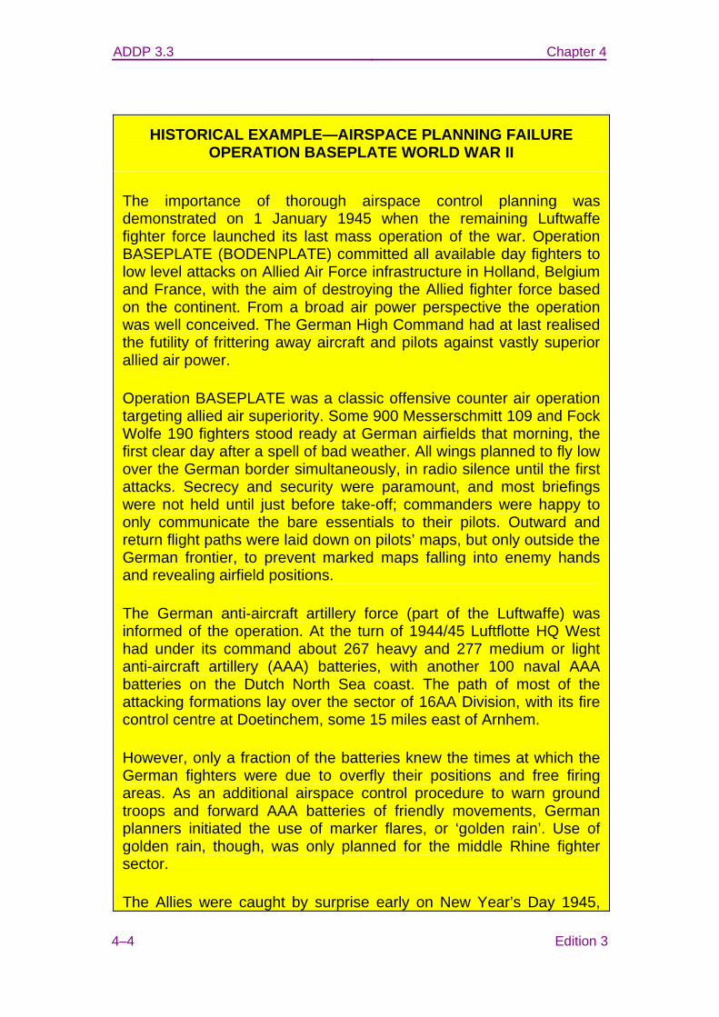
ADDP 3.3 Chapter 4
4–4 Edition 3
HISTORICAL EXAMPLE—AIRSPACE PLANNING FAILURE OPERATION BASEPLATE WORLD WAR II
The importance of thorough airspace control planning was demonstrated on 1 January 1945 when the remaining Luftwaffe fighter force launched its last mass operation of the war. Operation BASEPLATE (BODENPLATE) committed all available day fighters to low level attacks on Allied Air Force infrastructure in Holland, Belgium and France, with the aim of destroying the Allied fighter force based on the continent. From a broad air power perspective the operation was well conceived. The German High Command had at last realised the futility of frittering away aircraft and pilots against vastly superior allied air power.
Operation BASEPLATE was a classic offensive counter air operation targeting allied air superiority. Some 900 Messerschmitt 109 and Fock Wolfe 190 fighters stood ready at German airfields that morning, the first clear day after a spell of bad weather. All wings planned to fly low over the German border simultaneously, in radio silence until the first attacks. Secrecy and security were paramount, and most briefings were not held until just before take-off; commanders were happy to only communicate the bare essentials to their pilots. Outward and return flight paths were laid down on pilots’ maps, but only outside the German frontier, to prevent marked maps falling into enemy hands and revealing airfield positions.
The German anti-aircraft artillery force (part of the Luftwaffe) was informed of the operation. At the turn of 1944/45 Luftflotte HQ West had under its command about 267 heavy and 277 medium or light anti-aircraft artillery (AAA) batteries, with another 100 naval AAA batteries on the Dutch North Sea coast. The path of most of the attacking formations lay over the sector of 16AA Division, with its fire control centre at Doetinchem, some 15 miles east of Arnhem.
However, only a fraction of the batteries knew the times at which the German fighters were due to overfly their positions and free firing areas. As an additional airspace control procedure to warn ground troops and forward AAA batteries of friendly movements, German planners initiated the use of marker flares, or ‘golden rain’. Use of golden rain, though, was only planned for the middle Rhine fighter sector.
The Allies were caught by surprise early on New Year’s Day 1945,
ADDP 3.3 Chapter 4
Edition 3 4–5
and lost 500 aircraft, mostly destroyed on the ground. Nevertheless, Operation BASEPLATE was a disaster for the Luftwaffe, ensuring its virtual demise as a fighting force. Because of its overwhelming logistic superiority, Allied losses were easily replaced in two weeks, and the Luftwaffe lost 300 aircraft, a third of its force, and 214 pilots. However, the most frustrating thing for the Luftwaffe was that 100 of these losses were to its own AAA fire, a fratricide rate of nearly 30 per cent.
It is easy to criticise the Luftwaffe, particularly given their losses in the preceding six months since the invasion of Europe, and generally low pilot experience. Nevertheless, it was still a cohesive organisation, able to muster nearly 1000 fighters and almost 700 AAA batteries. Such a complex operation, which was actually well conceived from a broad air power perspective, required much more extensive airspace control planning and deliberate pre-flight briefing to ensure all elements understood the deconfliction arrangements.
Many take-offs from airfields in north-western Germany had been delayed by ground mist, and revised timings were not passed to the AAA batteries. When strong fighter forces approached at the wrong times, they were engaged. The golden rain marker flares did not always work properly, and most Luftwaffe pilots needlessly maintained radio silence until well after the attacks, adding to the confusion. Operation BASEPLATE is a definitive example of fratricide as a result of inadequate consideration of communication and information system requirements, command and control (C2), risk management and rules of engagement in the conduct of airspace control.
Airspace control means
4.7 Deliberate. Deliberate ACM are generated by the air and space operations centre (AOC) airspace planning team during development of the master air activity plan (MAAP) and are promulgated in the ACO. Airspace conflictions identified within the MAAP are resolved according to priorities, time and space, or through real time control of the airspace by a C2 agency.
4.8 Dynamic. Where an ACM is required, but is not promulgated as a deliberate ACM, it can be requested from the organic airspace control agency. This agency will either approve or deny the request, or coordinate the request with the appropriate higher airspace control agency.
ADDP 3.3 Chapter 5
Edition 3 5–1
CHAPTER 5
AIRSPACE CONTROL MEANS
Executive Summary
• An airspace control means (ACM) is a procedural method of defining a specific portion of airspace for a particular purpose.
• The Global Area Reference System (GARS) provides an unclassified, standardised, worldwide area reference system based on lines of longitude and latitude.
• A joint fires area (JFA) is a permissive fire support coordination measure (FSCM) enabling commanders to deliver joint fires against anticipated or opportunity targets in a common area.
Introduction
5.1 An ACM is a procedural method of defining a volume of airspace for a specific purpose. When established, ACM reserve airspace for users, restrict the action of airspace users and/or require airspace users to accomplish specific actions. ACM can also be used to identify friendly forces, providing separation from other friendly aircraft and avoiding the risk of engagement by friendly weapon systems. ACM are used for a wide range of airspace control and air defence purposes. Many are peculiar to maritime, land and counter air operations.
5.2 The airspace control means request format (see annex A) is used to request, change, or delete a specific ACM in an airspace control order (ACO).
5.3 The ACM detailed in this chapter are those which specifically relate to ADF airspace control or which provide for procedural separation between aircraft operating under different operational authorities at the tactical level. North Atlantic Treaty Organization and United States doctrine include additional ACM not generally used by the ADF, which may be used in multinational operations when circumstances warrant.
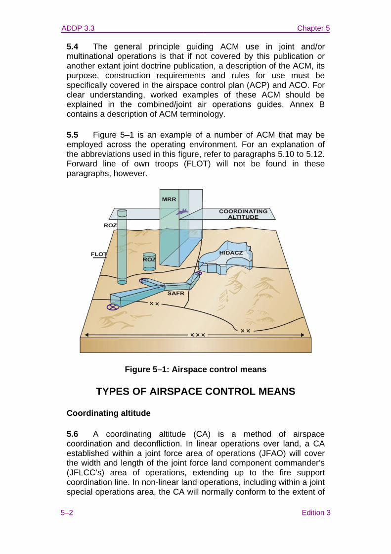
ADDP 3.3 Chapter 5
5–2 Edition 3
5.4 The general principle guiding ACM use in joint and/or multinational operations is that if not covered by this publication or another extant joint doctrine publication, a description of the ACM, its purpose, construction requirements and rules for use must be specifically covered in the airspace control plan (ACP) and ACO. For clear understanding, worked examples of these ACM should be explained in the combined/joint air operations guides. Annex B contains a description of ACM terminology.
5.5 Figure 5–1 is an example of a number of ACM that may be employed across the operating environment. For an explanation of the abbreviations used in this figure, refer to paragraphs 5.10 to 5.12. Forward line of own troops (FLOT) will not be found in these paragraphs, however.
Figure 5–1: Airspace control means
TYPES OF AIRSPACE CONTROL MEANS
Coordinating altitude
5.6 A coordinating altitude (CA) is a method of airspace coordination and deconfliction. In linear operations over land, a CA established within a joint force area of operations (JFAO) will cover the width and length of the joint force land component commander’s (JFLCC’s) area of operations, extending up to the fire support coordination line. In non-linear land operations, including within a joint special operations area, the CA will normally conform to the extent of
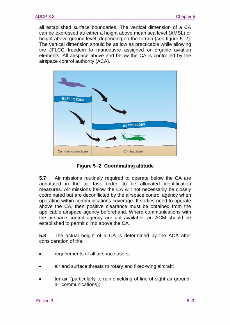
ADDP 3.3 Chapter 5
Edition 3 5–3
all established surface boundaries. The vertical dimension of a CA can be expressed as either a height above mean sea level (AMSL) or height above ground level, depending on the terrain (see figure 5–2). The vertical dimension should be as low as practicable while allowing the JFLCC freedom to manoeuvre assigned or organic aviation elements. All airspace above and below the CA is controlled by the airspace control authority (ACA).
Figure 5–2: Coordinating altitude
5.7 Air missions routinely required to operate below the CA are annotated in the air task order, to be allocated identification measures. Air missions below the CA will not necessarily be closely coordinated but are deconflicted by the airspace control agency when operating within communications coverage. If sorties need to operate above the CA, then positive clearance must be obtained from the applicable airspace agency beforehand. Where communications with the airspace control agency are not available, an ACM should be established to permit climb above the CA.
5.8 The actual height of a CA is determined by the ACA after consideration of the:
• requirements of all airspace users;
• air and surface threats to rotary and fixed-wing aircraft;
• terrain (particularly terrain shielding of line-of-sight air-ground-air communications);

ADDP 3.3 Chapter 5
5–4 Edition 3
• weather conditions;
• communications (including ground, airborne, aerostat and satellite retransmission) capabilities; and
• airspace control agency capabilities.
Airspace coordination area
5.9 An airspace coordination area (ASCA) is primarily a restrictive FSCM which is also used as an ACM (see figure 5–3). It is a three-dimensional block of airspace in which friendly aircraft are safe from friendly surface fire. An ASCA allows fire to be directed below, above, to the sides, but not through, the defined airspace. ASCA are developed by the Joint Fires and Effects Coordination Centre, Supporting Arms Coordination Centre, and/or tactical air control party (TACP) staff, and may be defined by grid coordinates or geographical features, as well as by minimum and maximum altitudes. ASCA must include time limitations in addition to lateral and vertical limits.
Figure 5–3: Airspace coordination area
High density airspace control zone
5.10 A high density airspace control zone (HIDACZ) is airspace of defined dimensions, designated by the ACA, over a specific area in
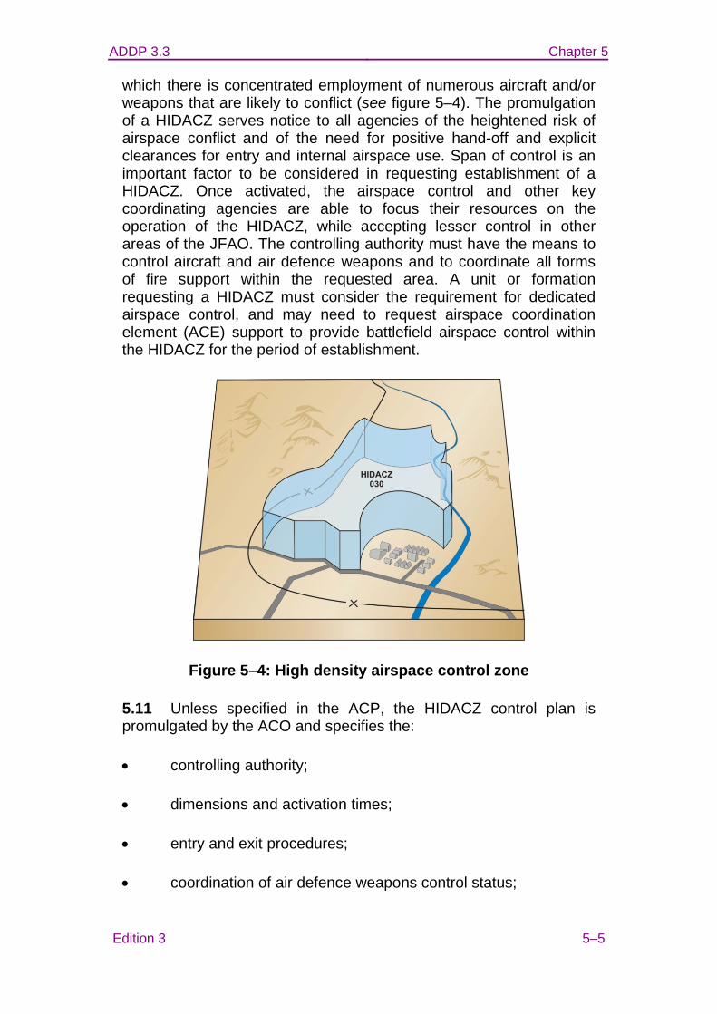
ADDP 3.3 Chapter 5
Edition 3 5–5
which there is concentrated employment of numerous aircraft and/or weapons that are likely to conflict (see figure 5–4). The promulgation of a HIDACZ serves notice to all agencies of the heightened risk of airspace conflict and of the need for positive hand-off and explicit clearances for entry and internal airspace use. Span of control is an important factor to be considered in requesting establishment of a HIDACZ. Once activated, the airspace control and other key coordinating agencies are able to focus their resources on the operation of the HIDACZ, while accepting lesser control in other areas of the JFAO. The controlling authority must have the means to control aircraft and air defence weapons and to coordinate all forms of fire support within the requested area. A unit or formation requesting a HIDACZ must consider the requirement for dedicated airspace control, and may need to request airspace coordination element (ACE) support to provide battlefield airspace control within the HIDACZ for the period of establishment.
Figure 5–4: High density airspace control zone
5.11 Unless specified in the ACP, the HIDACZ control plan is promulgated by the ACO and specifies the:
• controlling authority;
• dimensions and activation times;
• entry and exit procedures;
• coordination of air defence weapons control status;
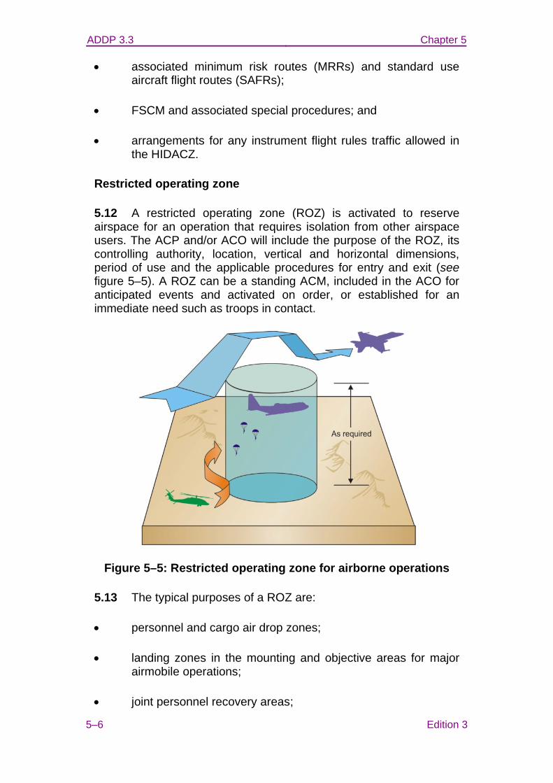
ADDP 3.3 Chapter 5
5–6 Edition 3
• associated minimum risk routes (MRRs) and standard use aircraft flight routes (SAFRs);
• FSCM and associated special procedures; and
• arrangements for any instrument flight rules traffic allowed in the HIDACZ.
Restricted operating zone
5.12 A restricted operating zone (ROZ) is activated to reserve airspace for an operation that requires isolation from other airspace users. The ACP and/or ACO will include the purpose of the ROZ, its controlling authority, location, vertical and horizontal dimensions, period of use and the applicable procedures for entry and exit (see figure 5–5). A ROZ can be a standing ACM, included in the ACO for anticipated events and activated on order, or established for an immediate need such as troops in contact.
Figure 5–5: Restricted operating zone for airborne operations
5.13 The typical purposes of a ROZ are:
• personnel and cargo air drop zones;
• landing zones in the mounting and objective areas for major airmobile operations;
• joint personnel recovery areas;
ADDP 3.3 Chapter 5
Edition 3 5–7
• special operations area;
• demolitions;
• field firing ranges;
• aerostat operations;
• forward arming and refuelling points, helicopter landing areas and forward airfields, when not covered by a manned air traffic control zone;
• air to air refuelling operations;
• electronic warfare operations;
• areas of acute noise or cultural sensitivity which, if exacerbated, may impact on the success of some types of military support operations;
• unmanned aerial system launch/recovery areas, blankets, mission or operating areas; and
• areas that do not warrant establishment of a HIDACZ but within which significant offensive air support, air surveillance and reconnaissance and surface-to-surface fire support assets are employed and need to be temporarily segregated from adjacent airspace.
Air-to-air refuelling
5.14 Air-to-air refuelling (AAR) requires airspace with large lateral dimensions that vary according to the AAR and receiver aircraft types. AAR aircraft are high value airborne assets and as such the track should be situated where the aircraft is not subject to attack or the refuelling aircraft should be accompanied by a combat air patrol. The track should encompass a minimum of 2000 feet vertical space for receiver aircraft to safely ingress and egress the AAR pattern.
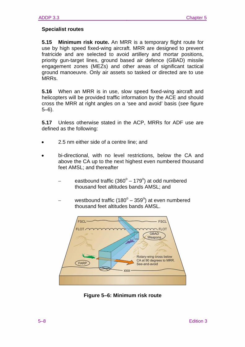
ADDP 3.3 Chapter 5
5–8 Edition 3
Specialist routes
5.15 Minimum risk route. An MRR is a temporary flight route for use by high speed fixed-wing aircraft. MRR are designed to prevent fratricide and are selected to avoid artillery and mortar positions, priority gun-target lines, ground based air defence (GBAD) missile engagement zones (MEZs) and other areas of significant tactical ground manoeuvre. Only air assets so tasked or directed are to use MRRs.
5.16 When an MRR is in use, slow speed fixed-wing aircraft and helicopters will be provided traffic information by the ACE and should cross the MRR at right angles on a ‘see and avoid’ basis (see figure 5–6).
5.17 Unless otherwise stated in the ACP, MRRs for ADF use are defined as the following:
• 2.5 nm either side of a centre line; and
• bi-directional, with no level restrictions, below the CA and above the CA up to the next highest even numbered thousand feet AMSL; and thereafter
− eastbound traffic (360o – 179o) at odd numbered thousand feet altitudes bands AMSL; and
− westbound traffic (180o – 359o) at even numbered thousand feet altitudes bands AMSL.
Figure 5–6: Minimum risk route
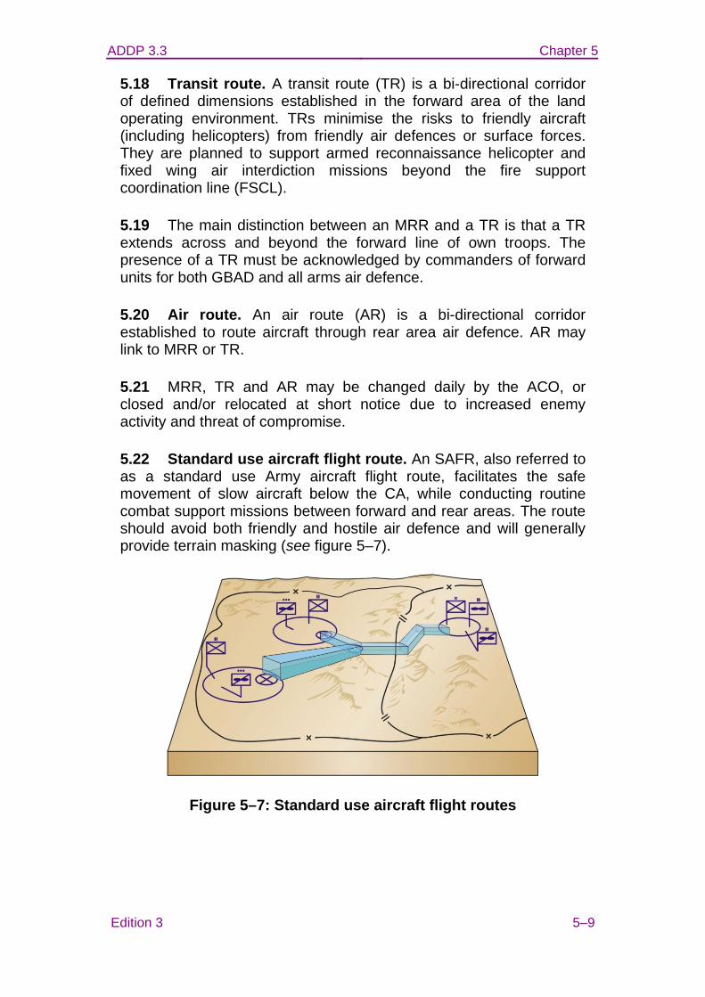
ADDP 3.3 Chapter 5
Edition 3 5–9
5.18 Transit route. A transit route (TR) is a bi-directional corridor of defined dimensions established in the forward area of the land operating environment. TRs minimise the risks to friendly aircraft (including helicopters) from friendly air defences or surface forces. They are planned to support armed reconnaissance helicopter and fixed wing air interdiction missions beyond the fire support coordination line (FSCL).
5.19 The main distinction between an MRR and a TR is that a TR extends across and beyond the forward line of own troops. The presence of a TR must be acknowledged by commanders of forward units for both GBAD and all arms air defence.
5.20 Air route. An air route (AR) is a bi-directional corridor established to route aircraft through rear area air defence. AR may link to MRR or TR.
5.21 MRR, TR and AR may be changed daily by the ACO, or closed and/or relocated at short notice due to increased enemy activity and threat of compromise.
5.22 Standard use aircraft flight route. An SAFR, also referred to as a standard use Army aircraft flight route, facilitates the safe movement of slow aircraft below the CA, while conducting routine combat support missions between forward and rear areas. The route should avoid both friendly and hostile air defence and will generally provide terrain masking (see figure 5–7).
Figure 5–7: Standard use aircraft flight routes
ADDP 3.3 Chapter 5
5–10 Edition 3
Other representative airspace control means
5.23 Missile engagement zone. A MEZ is airspace of defined dimensions within which GBAD or maritime anti-air warfare (AAW) systems are the primary method of engagement. The dimensions of a MEZ are determined according to weapon characteristics.
5.24 Crossover zone. The crossover zone (COZ) is the airspace beyond the MEZ that may be entered by combat air patrol (CAP) aircraft, when in pursuit, to complete an intercept. The CAP aircraft must give a countdown of seconds remaining to achieve engagement in order to inform a decision to continue or to hand-off the engagement to GBAD or AAW systems. A COZ normally extends far enough beyond the MEZ to allow a reasonable decision time.
5.25 Base defence zone. A base defence zone (BDZ) may be established around airbases, airfields or forward operating bases to enhance the effectiveness of GBAD. BDZ will be published in the ACP and activated in the ACO. The ACO will establish specific entry/exit procedures (including promulgation of safe lanes) and will reiterate identification friend or foe procedures for the BDZ.
5.26 Fighter engagement zone. A fighter engagement zone (FEZ) is airspace of defined dimensions within which the responsibility for engagement of air threats normally rests with fighter aircraft.
5.27 Amphibious objective area. An amphibious objective area (AOA) is a geographical area, delineated in the initiating directive for the purposes of command and control, within which is the objective(s) to be secured by the amphibious task force. This area must be of sufficient size to ensure accomplishment of the mission and tasks, and allow for effective use of amphibious, land and air assets and weapon effects. In airspace control terms, an AOA is a HIDACZ, established specifically for the conduct of an amphibious operation.
5.28 Ship control zone. A ship control zone (SCZ), illustrated in figure 5–8, is a localised area activated around a ship that is operating aircraft, such as recovery of an organic helicopter. The SCZ is usually a cylinder around the ship rising to a nominated height. For an escort the cylinder radius is 500 yards, rising to 500 feet. The zone is not to be entered by friendly aircraft without permission, in order to prevent friendly interference of the launch or recovery cycle.
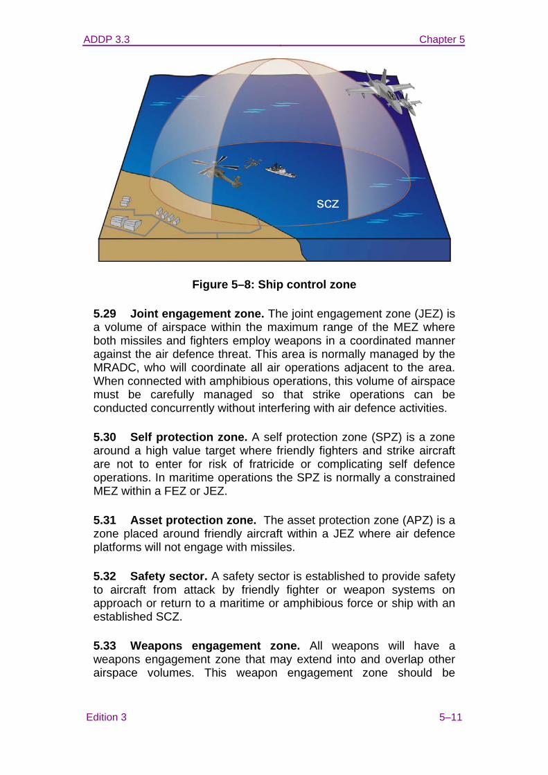
ADDP 3.3 Chapter 5
Edition 3 5–11
Figure 5–8: Ship control zone
5.29 Joint engagement zone. The joint engagement zone (JEZ) is a volume of airspace within the maximum range of the MEZ where both missiles and fighters employ weapons in a coordinated manner against the air defence threat. This area is normally managed by the MRADC, who will coordinate all air operations adjacent to the area. When connected with amphibious operations, this volume of airspace must be carefully managed so that strike operations can be conducted concurrently without interfering with air defence activities.
5.30 Self protection zone. A self protection zone (SPZ) is a zone around a high value target where friendly fighters and strike aircraft are not to enter for risk of fratricide or complicating self defence operations. In maritime operations the SPZ is normally a constrained MEZ within a FEZ or JEZ.
5.31 Asset protection zone. The asset protection zone (APZ) is a zone placed around friendly aircraft within a JEZ where air defence platforms will not engage with missiles.
5.32 Safety sector. A safety sector is established to provide safety to aircraft from attack by friendly fighter or weapon systems on approach or return to a maritime or amphibious force or ship with an established SCZ.
5.33 Weapons engagement zone. All weapons will have a weapons engagement zone that may extend into and overlap other airspace volumes. This weapon engagement zone should be
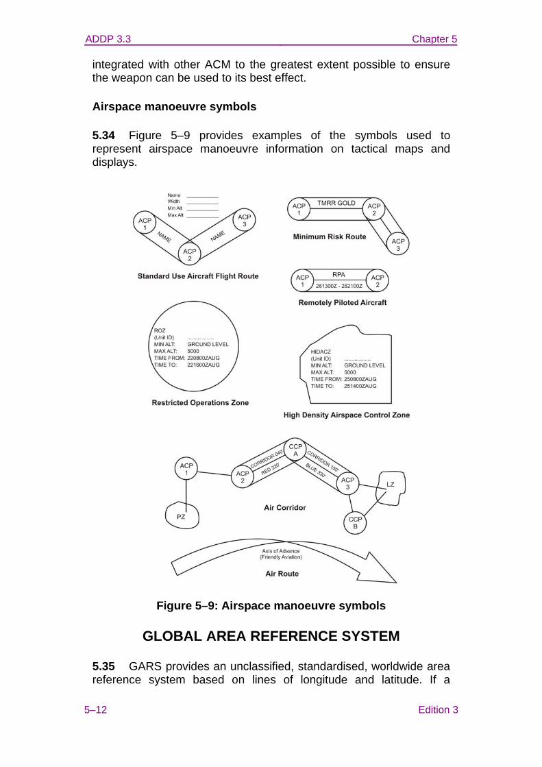
ADDP 3.3 Chapter 5
5–12 Edition 3
integrated with other ACM to the greatest extent possible to ensure the weapon can be used to its best effect.
Airspace manoeuvre symbols
5.34 Figure 5–9 provides examples of the symbols used to represent airspace manoeuvre information on tactical maps and displays.
Figure 5–9: Airspace manoeuvre symbols
GLOBAL AREA REFERENCE SYSTEM
5.35 GARS provides an unclassified, standardised, worldwide area reference system based on lines of longitude and latitude. If a
ADDP 3.3 Chapter 5
Edition 3 5–13
reference system is to be used, then it should be GARS unless there is an operational imperative (as determined by the joint task force (JTF) commander) for using an alternate reference system. Airspace planners should organise for the GARS overlays to be available for incorporation into charts and command and control (C2) systems, to be used throughout the JFAO.
5.36 GARS offers an integrated, common frame-of-reference for joint force situational awareness, to facilitate coordination, integration, deconfliction and synchronisation across the operating environment. By simplifying and standardising communications, the use of the GARS should enhance interoperability and reduce the risk of fratricide. GARS is primarily designed as an operating environment management tool and is not intended for navigation or targeting.
5.37 GARS is a two-dimensional reference system that can be used to develop three-dimensional and four-dimensional (time) control and coordination measures.
5.38 The key to employing GARS effectively is to ensure that coordination and management mechanisms are communicated rapidly to all users, are easily defined, and that C2 agencies are capable of activating/deactivating them as the operating environment develops.1
5.39 The GARS process does not supersede existing coordination mechanisms such as FSCM and airspace control means—it is a complementary system that improves the execution of operational activity across the operating environment.
5.40 The predecessor to GARS was the common geographic reference system (CGRS). Coalition military planners used CGRS effectively during Operation IRAQI FREEDOM to aid interdiction and close air support missions. However, CGRS is a regional system and around the world, numerous CGRS grids are in use, each with unique grid naming schemes. The GARS captures the benefits of CGRS while eliminating its regional inconsistencies. The GARS simplifies inter and intra-theatre coordination and thereby reduces the confusion associated with complex joint, combined and coalition operations.
1 Additional information and resources on GARS can be found at the United States National Geospatial Intelligence Agency website: http://earth-info.nga.mil/GandG/coordsys/grids/gars.html
ADDP 3.3 Chapter 5
5–14 Edition 3
GARS design
5.41 GARS divides the surface of the earth into 30 minute by 30 minute cells about 900 square nautical miles (nm2) at the equator, diminishing in size at higher latitudes north and south of the equator. Each 30 minute cell is further divided into four 15 minute by 15 minute quadrants. Each 15 minute quadrant is further divided into nine 5 minute by 5 minute areas known as keys.
5.42 Each 5 minute by 5 minute key can be designated by a seven character designation (for example 006AG39). Therefore, 5 minute by 5 minute areas anywhere in the world can be easily described with only seven characters, rather than transmitting four lengthy latitude-longitude coordinates, and users can define an area by a succinct number/letter character string.
GARS nomenclature
5.43 GARS uses a standard over-and-up cell address convention that divides the surface of the earth into 30 minute by 30 minute cells using a five character designation (for example 006AG). Additional characters are added, to a maximum of seven, to identify subordinate areas within the 30 minute by 30 minute cell (for example 006AG39).
5.44 The first three characters designate a 30 minute wide longitudinal band. Beginning with the 180 degree meridian and proceeding eastward, the bands are numbered from 001 to 720, so that 180 E to 179 30’W is band 001; 179 30’W to 179 00’W is band 002; and so on.
5.45 The fourth and fifth characters designate a 30 minute wide latitudinal band. Beginning at the south pole and proceeding northward, the bands are lettered from AA to QZ (omitting I and O) so that 90 00’S to 89 30’S is band AA; 89 30’S to 89 00’S is band AB; and so on. In the lower latitudes, each cell will be approximately 30nm by 30nm in size.
5.46 Each 30 minute cell is further divided into four 15 minute by 15 minute quadrants. The quadrants are numbered sequentially, from west to east, starting with the northernmost band. Specifically, the northwest quadrant is ‘1’; the northeast quadrant is ‘2’; the southwest quadrant is ‘3’; the southeast quadrant is ‘4’. Each quadrant is identified by a six character designation (for example 006AG3). The first five characters comprise the 30 minute cell designation. The sixth character is the quadrant number. In the lower latitudes, each quadrant will be approximately 15nm by 15nm in size (225 nm2).

ADDP 3.3 Chapter 5
Edition 3 5–15
5.47 Each 15 minute quadrant can be further divided into nine 5 minute by 5 minute keys. The areas are numbered sequentially, from west to east, starting with the northernmost band. The graphical representation of a 15 minute quadrant with numbered 5 minute by 5 minute areas resembles a telephone keypad. Each 5 minute by 5 minute key is identified by a seven character designation. The first six characters comprise the 15 minute quadrant designation. The seventh character is the keypad ‘key’ number (for example 006AG39). In the lower latitudes, each key will be approximately 5nm by 5nm in size. Figure 5–10 depicts the GARS grid structure graphically.
Figure 5–10: Global Area Reference System graphical depiction
Employing GARS in the airspace control system
5.48 GARS can be used as the two dimensional structure upon which three dimensional (altitude) or four dimensional (time) control and coordination measures can be built. In general, GARS can be used to define an area whenever specific topographical features are not required and/or applicable for area coordination. For example, it can be used for maritime water-space management, named areas of interest, restricted fires areas, and other airspace control means such as JFA, no fires areas and airspace coordination areas. GARS can
ADDP 3.3 Chapter 5
5–16 Edition 3
also be used to describe search and rescue (SAR) areas and other emergency relief regions.
5.49 As with all control and coordination measures, the information is best distributed using digital systems that source centrally managed map overlays to ensure the integrity of the displayed information. Accordingly, GARS utility will be enhanced by the incorporation of map overlays and standardised messages in, for example, Joint Automated Deep Operations Coordination System or Theatre Battle Management Core Systems (TBMCS). Given adequate assurance that the overlay is correct, virtually every headquarters and C2 node can use GARS cell, quadrant, and key information, plus altitudes, times, ‘ownership’ and operational status/purpose to disseminate battle management information.
5.50 The following provides examples of activities to which GARS may be applied:
• Joint fires area. A JFA is a three-dimensional permissive FSCM used to facilitate rapid engagement of targets with air-to-surface and surface-to-surface fires, whilst affording the protective features of an airspace coordination area. The effects area and airspace of a JFA can be described using GARS cells, quadrants and or keys.
• Other fire support coordination measures. GARS may be used to define virtually any FSCM or airspace coordination measure that is not dependant upon topographical features. Examples include, but are not limited to, airspace coordination area, amphibious objective area, component boundary, buffer zone, safety sector, weapons free zone, and coordinated air defence area.
• Deconfliction of mutually exclusive airspace users. GARS can be used to define the airspace used by surface-to-surface indirect fire weapons by grouping keys, airspace and time windows to provide procedural separation between such systems and other airspace users.
• Maritime applications. GARS can be used to effectively manage water space, such as for maritime interdiction and defence, merchant escort and harbour entry. Because it is unclassified and global, the GARS is useful for amending warning and readiness status in particular cells, quadrants and keys within a larger operating area, and publishing this information to coalition partners who may not have access to

ADDP 3.3 Chapter 5
Edition 3 5–17
the same C2 systems, as well as advising non-military agencies through Notice to Mariners and Notice to Airmen.
• Restricted operating zones. GARS can be used to define all manner of restricted operating zones, such as air-to-air refuelling areas, air corridors, close air support holding areas, drop zones, no fire areas, uninhabited aerial system blankets and no fly areas.
• Air traffic control. Provided adequate electronic maps are available to air traffic control agencies, GARS can be used to facilitate rapid temporary airspace release as may be required to facilitate emergency or weather diversions of civilian aircraft through military restricted airspace. The same principle may facilitate flexible use of airspace for civilian aircraft on user preferred trajectories, and military aircraft conducting training in civilian airspace normally beyond the military area boundary, such as in temporary airspace reservation areas.
• Search and rescue. GARS can be used to define SAR boundaries and areas of responsibility or to describe temporary airspace releases for civilian SAR within active military airspace.
• Intelligence. Operations planners can use GARS to define named areas of interest and target areas of interest. The same area references can be used by component commanders in air support requests.
JOINT FIRES AREA
5.51 A JFA is a three-dimensional, permissive FSCM used to facilitate the delivery of fires and effects without further coordination with the establishing commander. JFA are not mandatory and do not replace extant procedures for close air support (CAS), or pre-planned air interdiction against fixed targets. Rather, JFA enable all forces to effect collaborative joint fires against planned or opportunity targets in a common area using a common FSCM, while providing aircraft with the protection of a formal airspace coordination area. In short, JFA provide a FSCM to enable the Commander JTF (CJTF) to bring to bear all appropriate capabilities against a given target set. Airspace planners, managers and control agencies must understand that the JFA is a FSCM that can be employed across the JFAO.
5.52 A JFA has two attributes: location and time. The location element comprises the effects area, an area on the surface or sub-
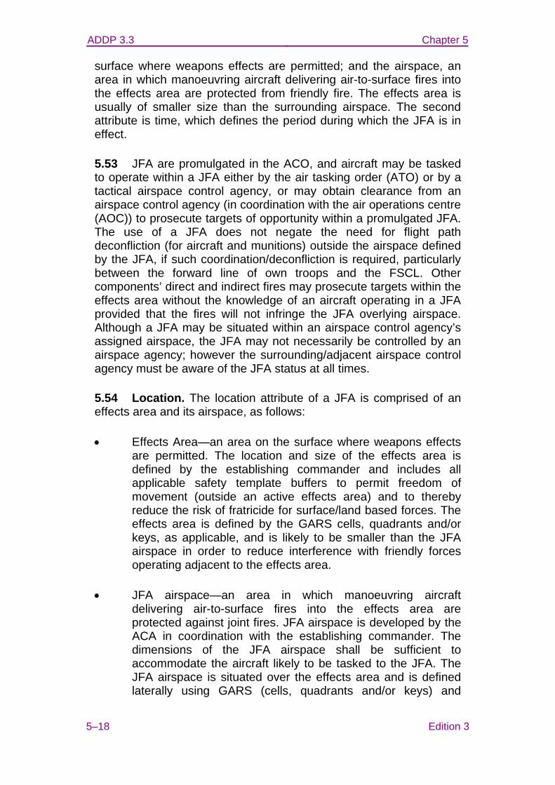
ADDP 3.3 Chapter 5
5–18 Edition 3
surface where weapons effects are permitted; and the airspace, an area in which manoeuvring aircraft delivering air-to-surface fires into the effects area are protected from friendly fire. The effects area is usually of smaller size than the surrounding airspace. The second attribute is time, which defines the period during which the JFA is in effect.
5.53 JFA are promulgated in the ACO, and aircraft may be tasked to operate within a JFA either by the air tasking order (ATO) or by a tactical airspace control agency, or may obtain clearance from an airspace control agency (in coordination with the air operations centre (AOC)) to prosecute targets of opportunity within a promulgated JFA. The use of a JFA does not negate the need for flight path deconfliction (for aircraft and munitions) outside the airspace defined by the JFA, if such coordination/deconfliction is required, particularly between the forward line of own troops and the FSCL. Other components’ direct and indirect fires may prosecute targets within the effects area without the knowledge of an aircraft operating in a JFA provided that the fires will not infringe the JFA overlying airspace. Although a JFA may be situated within an airspace control agency’s assigned airspace, the JFA may not necessarily be controlled by an airspace agency; however the surrounding/adjacent airspace control agency must be aware of the JFA status at all times.
5.54 Location. The location attribute of a JFA is comprised of an effects area and its airspace, as follows:
• Effects Area—an area on the surface where weapons effects are permitted. The location and size of the effects area is defined by the establishing commander and includes all applicable safety template buffers to permit freedom of movement (outside an active effects area) and to thereby reduce the risk of fratricide for surface/land based forces. The effects area is defined by the GARS cells, quadrants and/or keys, as applicable, and is likely to be smaller than the JFA airspace in order to reduce interference with friendly forces operating adjacent to the effects area.
• JFA airspace—an area in which manoeuvring aircraft delivering air-to-surface fires into the effects area are protected against joint fires. JFA airspace is developed by the ACA in coordination with the establishing commander. The dimensions of the JFA airspace shall be sufficient to accommodate the aircraft likely to be tasked to the JFA. The JFA airspace is situated over the effects area and is defined laterally using GARS (cells, quadrants and/or keys) and
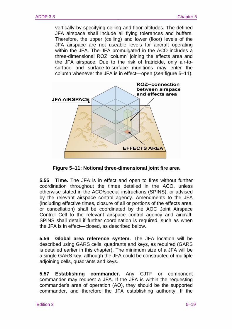
ADDP 3.3 Chapter 5
Edition 3 5–19
vertically by specifying ceiling and floor altitudes. The defined JFA airspace shall include all flying tolerances and buffers. Therefore, the upper (ceiling) and lower (floor) levels of the JFA airspace are not useable levels for aircraft operating within the JFA. The JFA promulgated in the ACO includes a three-dimensional ROZ ‘column’ joining the effects area and the JFA airspace. Due to the risk of fratricide, only air-to-surface and surface-to-surface munitions may enter the column whenever the JFA is in effect—open (see figure 5–11).
Figure 5–11: Notional three-dimensional joint fire area
5.55 Time. The JFA is in effect and open to fires without further coordination throughout the times detailed in the ACO, unless otherwise stated in the ACO/special instructions (SPINS), or advised by the relevant airspace control agency. Amendments to the JFA (including effective times, closure of all or portions of the effects area, or cancellation) shall be coordinated by the AOC Joint Airspace Control Cell to the relevant airspace control agency and aircraft. SPINS shall detail if further coordination is required, such as when the JFA is in effect—closed, as described below.
5.56 Global area reference system. The JFA location will be described using GARS cells, quadrants and keys, as required (GARS is detailed earlier in this chapter). The minimum size of a JFA will be a single GARS key, although the JFA could be constructed of multiple adjoining cells, quadrants and keys.
5.57 Establishing commander. Any CJTF or component commander may request a JFA. If the JFA is within the requesting commander’s area of operation (AO), they should be the supported commander, and therefore the JFA establishing authority. If the
ADDP 3.3 Chapter 5
5–20 Edition 3
requested JFA is in another commander’s AO, the commander with jurisdiction over that AO is the establishing authority. While all JFAs should be coordinated through the AOC, only the component commander responsible for an AO can establish a JFA in that AO.
5.58 Promulgation. JFAs shall be promulgated in the ACO and SPINS. Responsibility for monitoring and receiving coordination regarding the JFA will be assigned to a particular airspace control agency such as a TACP, ACE, an airborne early warning and control aircraft or control and reporting centre, depending upon the AO or airspace volume within which the JFA is located. JFAs shall be assigned a common frequency in order for aircraft entering/transiting the JFA airspace to integrate and deconflict their activities. In such cases, the first aircraft entering the JFA becomes the JFA coordinator until the JFA is vacated or the coordinating responsibility is transferred to another aircraft, such as forward air control-airborne or strike coordination and reconnaissance aircraft. Radio procedures for JFAs should be specified in the ACP. Example radio procedures are detailed at annex C.
5.59 Passage through JFA airspace. Aircraft and the trajectories of air-to-surface and surface-to-surface fires not in support of the JFA are not permitted to pass through the JFA airspace without confirmation from the surrounding airspace control agency or JFA coordinator that transit of the JFA is approved. For a JFA forward of the FSCL and not within an airspace control agency’s airspace (such as in a joint special operations area), transiting aircraft shall broadcast on the JFA common frequency to determine whether or not transit of the JFA is available. At all times, air-to-surface and surface-to-surface fires from agencies other than the JFA-tasked aircraft are not permitted within the JFA airspace.
5.60 Airborne radio procedures associated with JFAs are provided at annex C.
5.61 Overlap with other control/coordination means. A JFA may contain other airspace control means and FSCM within its boundaries (eg no-fire areas (NFAs), ROZ and airspace coordination areas).
5.62 Fire support coordination measures. JFAs do not supersede restrictive FSCM such as NFAs. Friendly forces cannot manoeuvre within or enter a JFA effects area while that JFA is in effect—open, unless those forces remain within a restrictive FSCM located within the effects area. Accordingly, if circumstances require protection of a friendly force (eg special operations forces,
ADDP 3.3 Chapter 5
Edition 3 5–21
reconnaissance patrols, littoral operations) within a JFA effects area, then a restrictive FSCM shall be promulgated.
5.63 Confliction with CAS. JFAs are a permissive FSCM intended for prosecuting targets of opportunity and anticipated targets in locations where friendly forces are not expected to operate, therefore tactical coordination should not be required. By definition, JFAs are not designed for CAS. In circumstances when CAS is to be conducted within an open effects area, portions or all of the JFA effects area shall be closed to facilitate CAS. Such closure shall be coordinated through the AOC to all affected components and approved by the JFA establishing authority. Although portions or all of the JFA effects area may be closed, JFA airspace may continue to overlay active CAS operations.
5.64 JFA coordination rear of the FSCL. To ensure timely deconfliction of the JFA from CAS, aircraft operating in a JFA that are rear of the FSCL should monitor the airspace agency responsible for the airspace surrounding the JFA. That surrounding airspace agency will normally be the air battle management C2 agency (regional operations centre) or TACP/ACE. However, the JFA aircraft may be directed to monitor a joint terminal attack controller frequency. The AOC must be informed of any temporary changes to the JFA effects area or airspace agreed by tactical agencies and aircraft.
Naming convention
5.65 JFA naming will be consistent with the naming convention used to identify and track FSCM. The JFA name will identify the FSCM as a JFA [JF], the number of the measure [001-999], and the establishing authority [eg LCC = JFLCC]. In addition to the JFA name, a date time group depicting the ‘open’ and ‘closed’ times for the JFA shall be included. The open and closed times may be written as on-order (O/O). The unit identifier for the establishing authority will be consistent with designations in operation plans and operation orders. JFA names will not be used more than once. Examples of JFA naming are as follows:
• Example 1: JF020LCC 240600ZJUN08 – 241000ZJUN08 The 20th JFA established by JFLCC (establishing authority) and the JFA is ‘open’ at 240600Z and ‘closed’ at 241000Z.
• Example 2: JF022ACC 180600ZJUN08 – O/O The 22nd JFA established by the joint force air component
ADDP 3.3 Chapter 5
5–22 Edition 3
commander and the JFA is ‘open’ at 180600ZJUN 08 and is ‘closed’ on order.
Terminology
5.66 There are specific terms used to describe the status of a JFA. Operational terms deal with status of an FSCM and tactical air-operations terms are used for the status of fires (see figure 5–12), and to ensure situational awareness and control as follows:
• Operational terms—status of FSCM:
− Planned. Coordination is complete and the JFA is promulgated.
− In effect. The JFA is available for use.
− Cancelled. The JFA is no longer in effect.
• Tactical air-operations terms—status of fires:
− Open. Open is the term used to describe a portion or portions of an in effect JFA effects area open to fires without further coordination or deconfliction. A JFA that is in effect is inherently open unless/until closed or cancelled.
− Active. A JFA that has aircraft flying within the airspace or has effects of other joint fires within the boundaries of the JFA.
− Cold. A JFA that is in effect but is not active. All portions of the JFA are open to fires unless identified as closed.
− Closed. Term used to describe a portion or portions of an in effect JFA effects area in which fires are not allowed without further coordination.
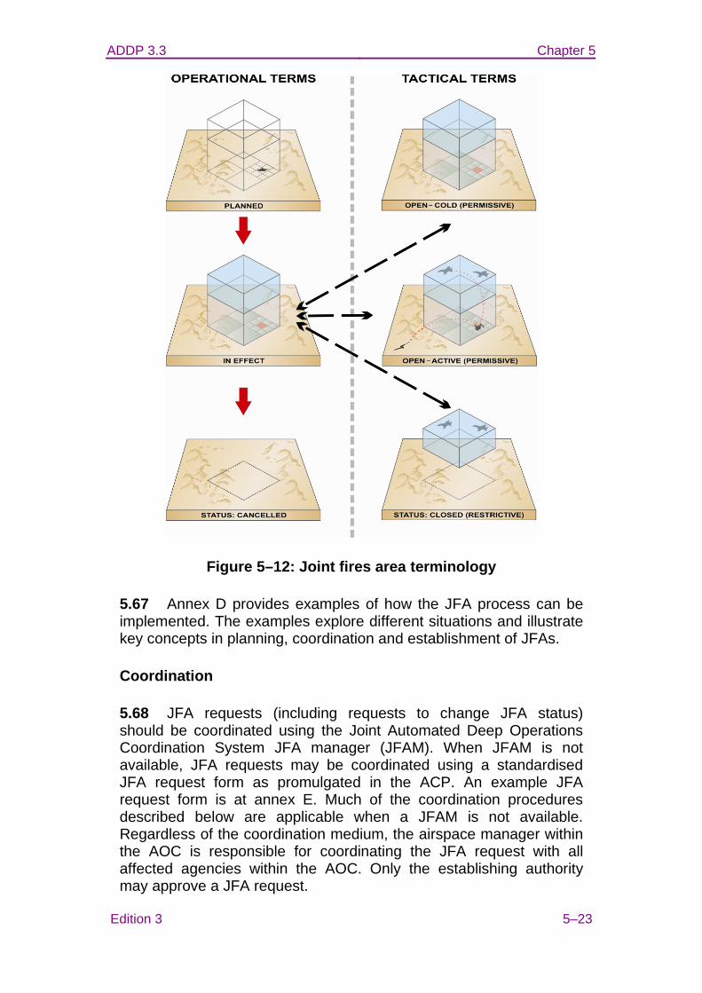
ADDP 3.3 Chapter 5
Edition 3 5–23
Figure 5–12: Joint fires area terminology
5.67 Annex D provides examples of how the JFA process can be implemented. The examples explore different situations and illustrate key concepts in planning, coordination and establishment of JFAs.
Coordination
5.68 JFA requests (including requests to change JFA status) should be coordinated using the Joint Automated Deep Operations Coordination System JFA manager (JFAM). When JFAM is not available, JFA requests may be coordinated using a standardised JFA request form as promulgated in the ACP. An example JFA request form is at annex E. Much of the coordination procedures described below are applicable when a JFAM is not available. Regardless of the coordination medium, the airspace manager within the AOC is responsible for coordinating the JFA request with all affected agencies within the AOC. Only the establishing authority may approve a JFA request.
ADDP 3.3 Chapter 5
5–24 Edition 3
5.69 The airspace manager coordinates the JFA with the relevant AOC divisions, teams and elements, depending on whether the JFA is requested pre or post-ACO publication. The airspace manager is responsible for ensuring that the JFA coordination checklist is completed prior to promulgating, or changing the status of, any JFA. The airspace manager shall advise the success/otherwise of the JFA request to the requesting agency and any applicable AOC divisions.
5.70 Pre-ACO publication. Requests for JFAs pre-ACO publication are to be coordinated with the targeting effects team (TET)/master air plan (MAP) team and considered with regard to any conflicting priorities, missions and effects. The airspace manager shall direct the airspace planner within the TET/MAP team to enter the JFA attributes into the TBMCS and complete the coordination. TET/MAP team representatives of each affected headquarters/command shall coordinate with their respective organisation, as required, and confirm to the airspace planner whether or not their respective headquarters/command concurs with the JFA. Once all affected headquarters/command coordination is complete, and subject to approval by the establishing authority, the JFA (effects area, airspace and column) shall be published in the ACO and usage procedures promulgated in the applicable SPINS. JFAs published in the ACO and SPINS need not be coordinated further unless a change to the location or timing (including closure) becomes necessary.
5.71 Air missions may be tasked to published JFAs in the ATO by assigning them to the JFA airspace, which is placed in the mission location (eg JF0020LCC). JFA coordinator details and frequency are included in ATO mission information. Additional details may be included in the SPINS.
5.72 Post-ACO publication. Requests for, or changes to, a JFA post-ACO publication shall be coordinated using extant procedures for deconfliction, clearance of fires and coordination. The AOC will identify and resolve conflictions with existing airspace control means, and then coordinate as follows:
• with the command and control duty officer (C2DO), senior offensive duty officer (SODO) and senior air defence officer for coordination with tactical command and control agencies;
• with the special operations liaison element for coordination with the joint forces special operations component; and
• with the battlefield coordination detachment for coordination
ADDP 3.3 Chapter 5
Edition 3 5–25
with the JFLCC’s joint offensive support coordination centre (particularly the TACP/ACE).
5.73 Component headquarters and supporting tactical agencies shall confirm that the JFA request or status change, as applicable, can be accommodated given the current and anticipated disposition of forces, aircraft and munitions. In circumstances where JFAM is not available, the ACP shall define the coordination flow through the respective command chain.
5.74 Once the JFA request or status change is approved/denied by the establishing authority and all agencies have completed coordination, the result of that coordination shall be advised to all agencies. The decision is effective immediately (noting that the in effect time attribute of the JFA may not commence until later). The JFA request or status change should then be promulgated in applicable orders such as the ATO, ACO, SPINS and fragmentary order. These published orders will direct all affected C2 agencies to execute the JFA, if applicable. SODO/C2DO and airspace command and control agencies may re-task assets to operate within the JFA once it is in effect—open.
5.75 Ingress/egress of JFA-tasked aircraft. Prior to tasked aircraft entering the JFA, the airspace C2 agency shall confirm to the aircraft the JFA tactical status: open—cold (fires permitted); open—active (fires underway); or closed (fires subject to further coordination). To avoid conflictions immediately upon entering/leaving the JFA airspace, SPINS should describe ingress and egress procedures. Whilst operating in the JFA, the JFA coordinator will monitor the surrounding airspace C2 agency frequency for status changes. The JFA coordinator and any subsequent formation leader will broadcast on the designated JFA frequency when entering and departing the JFA.
5.76 Deconfliction. If necessary, the JFA coordinator shall ask the surrounding airspace C2 agency to hold aircraft outside the JFA airspace until the JFA coordinator confirms that additional aircraft may enter. Within the JFA airspace, the JFA coordinator shall deconflict aircraft from each other and from air-to-surface fires, as required. Deconfliction may be achieved either vertically (holding other aircraft above the firing aircraft) or laterally (holding aircraft over GARS cells, quadrants or keys that do not overlie the effects area). Restrictive FSCM, such as no fires areas, may exist within the JFA effects area and must be complied with. Aircraft tasked to a JFA must comply with promulgated SPINS for that JFA.
ADDP 3.3 Chapter 5
5–26 Edition 3
Annexes: A. Airspace control means request B. Airspace coordination terms C. Airborne radio procedures D. Joint fires areas examples E. Joint fires area request/coordination form
ADDP 3.3 ANNEX A TO
CHAPTER 5
Edition 3 5A–1
AIRSPACE CONTROL MEANS REQUEST
1. The airspace control means request (ACMREQ) format is available, within the IRIS forms editor application, on the Defence Restricted Network and Defence Secret Network. Message text format forms can be created, imported and transmitted via Microsoft Outlook email or via the Mercury tactical and desktop messaging system.
2. The template format for an ACMREQ is as follows:
Heading: Airspace control means request.
Line 1. Name of command or region.
Line 2. Name of agency or agency requesting airspace.
Line 3. Type of airspace requested (see annex D).
Line 4. Name of airspace (must not use an existing name/call sign).
Line 5. Purpose.
Line 6. Transit instructions.
Line 7. Date-time group that establishment is required.
Line 8. Date-time group that disestablishment is required.
Line 9. Area. Description of the area to be established (for example, circle, boundary, radial arc, point, corridor).
Line 10. Coordinates (of boundary lines, centre line or centre point for a circle or arc) provided in latitude and longitude, minutes and seconds to the nearest tenth of a second using WGS-84, or expressed as Global Area Reference System cell(s), quadrant(s) or key(s).
Line 11. Width or radius (specify unit of measure: metres, feet, kilometres, nautical miles, etc).
Line 12. Lower altitude of the designated area to the nearest
ADDP 3.3
5A–2 Edition 3
100 feet.
Line 13. Upper altitude of the designated area to the nearest 100 feet.
Line 14. Call sign of control agency.
Line 15. Primary frequency or its frequency designator.
Line 16. Secondary frequency or its frequency designator.
Line 17. Narrative.
Line 18. Date-time group of approved submission.
Line 19. Authentication.
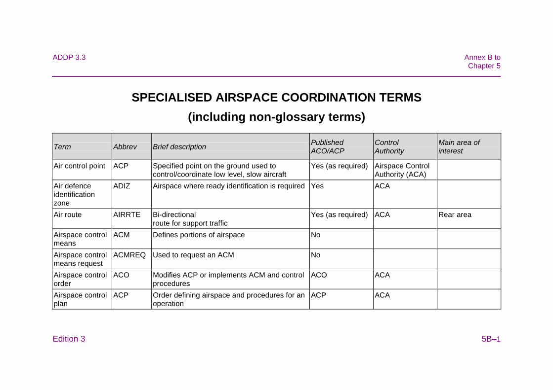
ADDP 3.3 Annex B toChapter 5
Edition 3 5B–1
SPECIALISED AIRSPACE COORDINATION TERMS (including non-glossary terms)
Term Abbrev Brief description Published ACO/ACP
Control Authority
Main area of interest
Air control point ACP Specified point on the ground used to control/coordinate low level, slow aircraft
Yes (as required) Airspace Control Authority (ACA)
Air defence identification zone
ADIZ Airspace where ready identification is required Yes ACA
Air route AIRRTE
Bi-directional route for support traffic
Yes (as required) ACA Rear area
Airspace control means
ACM Defines portions of airspace No
Airspace control means request
ACMREQ Used to request an ACM No
Airspace control order
ACO Modifies ACP or implements ACM and control procedures
ACO ACA
Airspace control plan
ACP Order defining airspace and procedures for an operation
ACP ACA
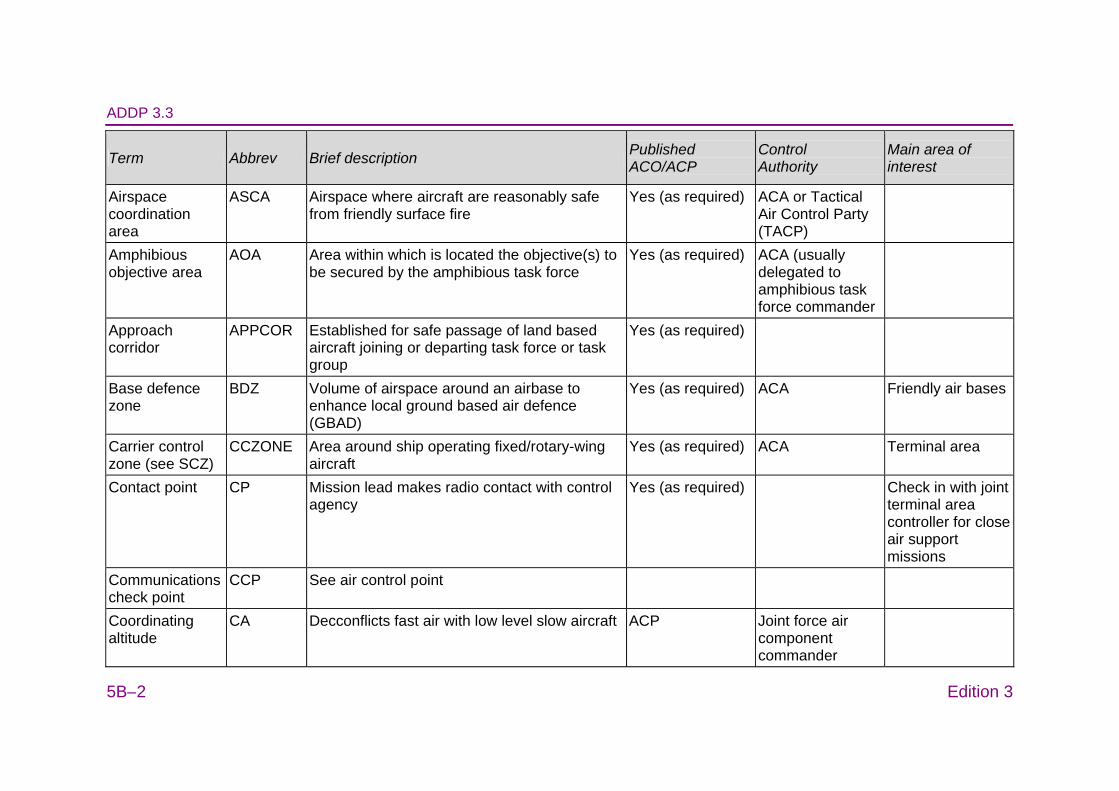
ADDP 3.3
5B–2 Edition 3
Term Abbrev Brief description Published ACO/ACP
Control Authority
Main area of interest
Airspace coordination area
ASCA Airspace where aircraft are reasonably safe from friendly surface fire
Yes (as required) ACA or Tactical Air Control Party (TACP)
Amphibious objective area
AOA Area within which is located the objective(s) to be secured by the amphibious task force
Yes (as required) ACA (usually delegated to amphibious task force commander
Approach corridor
APPCOR Established for safe passage of land based aircraft joining or departing task force or task group
Yes (as required)
Base defence zone
BDZ
Volume of airspace around an airbase to enhance local ground based air defence (GBAD)
Yes (as required) ACA Friendly air bases
Carrier control zone (see SCZ)
CCZONE Area around ship operating fixed/rotary-wing aircraft
Yes (as required) ACA Terminal area
Contact point CP Mission lead makes radio contact with control agency
Yes (as required) Check in with joint terminal area controller for close air support missions
Communications check point
CCP See air control point
Coordinating altitude
CA Decconflicts fast air with low level slow aircraft ACP Joint force air component commander
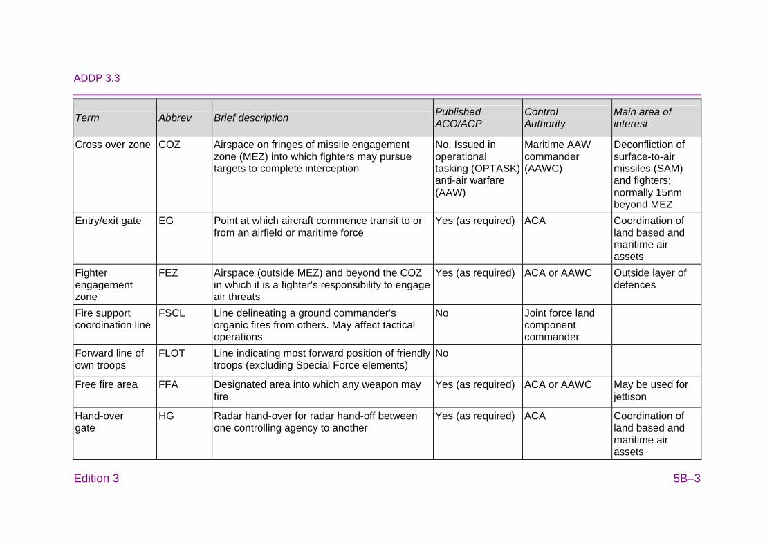
ADDP 3.3
Edition 3 5B–3
Term Abbrev Brief description Published ACO/ACP
Control Authority
Main area of interest
Cross over zone COZ Airspace on fringes of missile engagement zone (MEZ) into which fighters may pursue targets to complete interception
No. Issued in operational tasking (OPTASK) anti-air warfare (AAW)
Maritime AAW commander (AAWC)
Deconfliction of surface-to-air missiles (SAM) and fighters; normally 15nm beyond MEZ
Entry/exit gate EG Point at which aircraft commence transit to or from an airfield or maritime force
Yes (as required) ACA Coordination of land based and maritime air assets
Fighter engagement zone
FEZ Airspace (outside MEZ) and beyond the COZ in which it is a fighter’s responsibility to engage air threats
Yes (as required) ACA or AAWC Outside layer of defences
Fire support coordination line
FSCL Line delineating a ground commander’s organic fires from others. May affect tactical operations
No Joint force land component commander
Forward line of own troops
FLOT Line indicating most forward position of friendly troops (excluding Special Force elements)
No
Free fire area FFA Designated area into which any weapon may fire
Yes (as required) ACA or AAWC May be used for jettison
Hand-over gate
HG Radar hand-over for radar hand-off between one controlling agency to another
Yes (as required) ACA Coordination of land based and maritime air assets
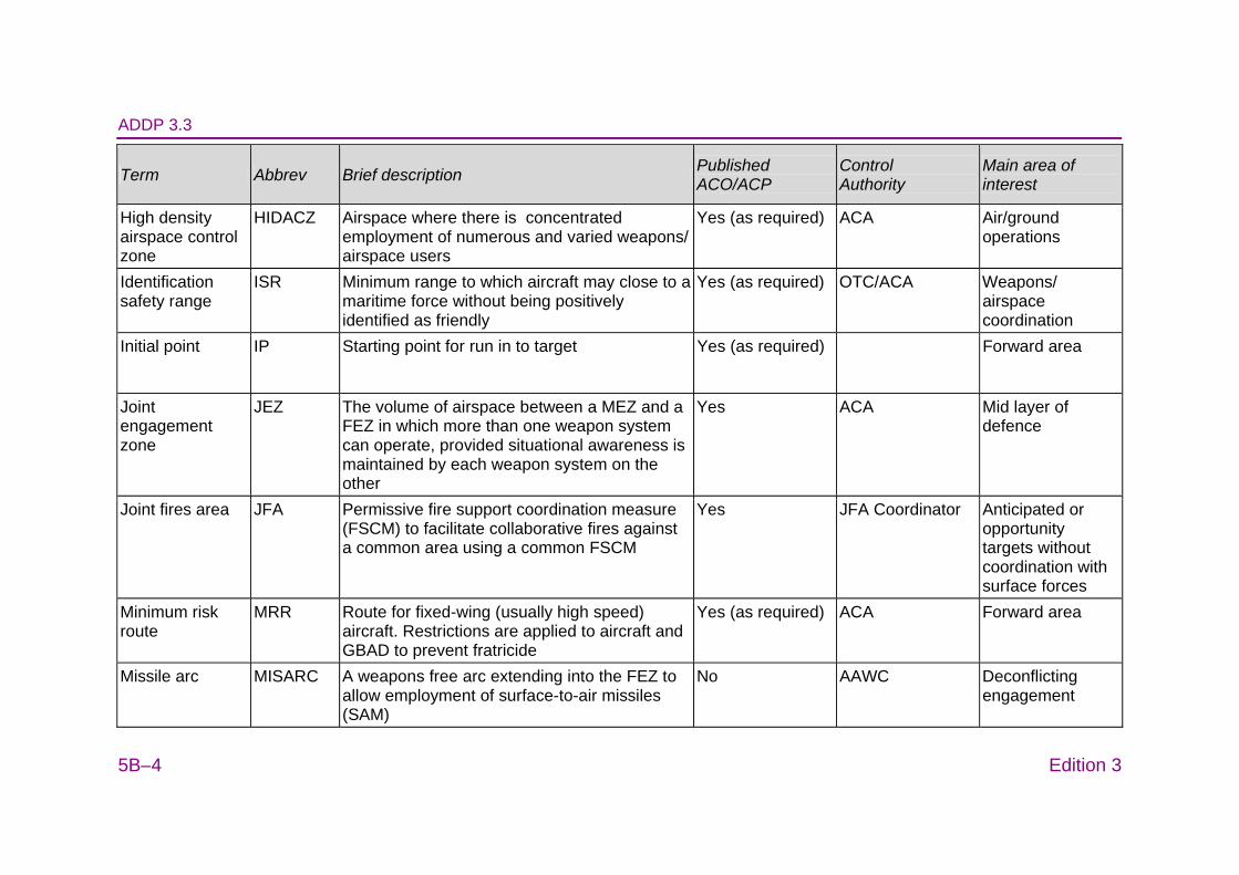
ADDP 3.3
5B–4 Edition 3
Term Abbrev Brief description Published ACO/ACP
Control Authority
Main area of interest
High density airspace control zone
HIDACZ Airspace where there is concentrated employment of numerous and varied weapons/ airspace users
Yes (as required) ACA Air/ground operations
Identification safety range
ISR Minimum range to which aircraft may close to a maritime force without being positively identified as friendly
Yes (as required) OTC/ACA Weapons/ airspace coordination
Initial point IP Starting point for run in to target Yes (as required) Forward area
Joint engagement zone
JEZ The volume of airspace between a MEZ and a FEZ in which more than one weapon system can operate, provided situational awareness is maintained by each weapon system on the other
Yes ACA Mid layer of defence
Joint fires area JFA Permissive fire support coordination measure (FSCM) to facilitate collaborative fires against a common area using a common FSCM
Yes JFA Coordinator Anticipated or opportunity targets without coordination with surface forces
Minimum risk route
MRR Route for fixed-wing (usually high speed) aircraft. Restrictions are applied to aircraft and GBAD to prevent fratricide
Yes (as required) ACA Forward area
Missile arc MISARC A weapons free arc extending into the FEZ to allow employment of surface-to-air missiles (SAM)
No AAWC Deconflicting engagement
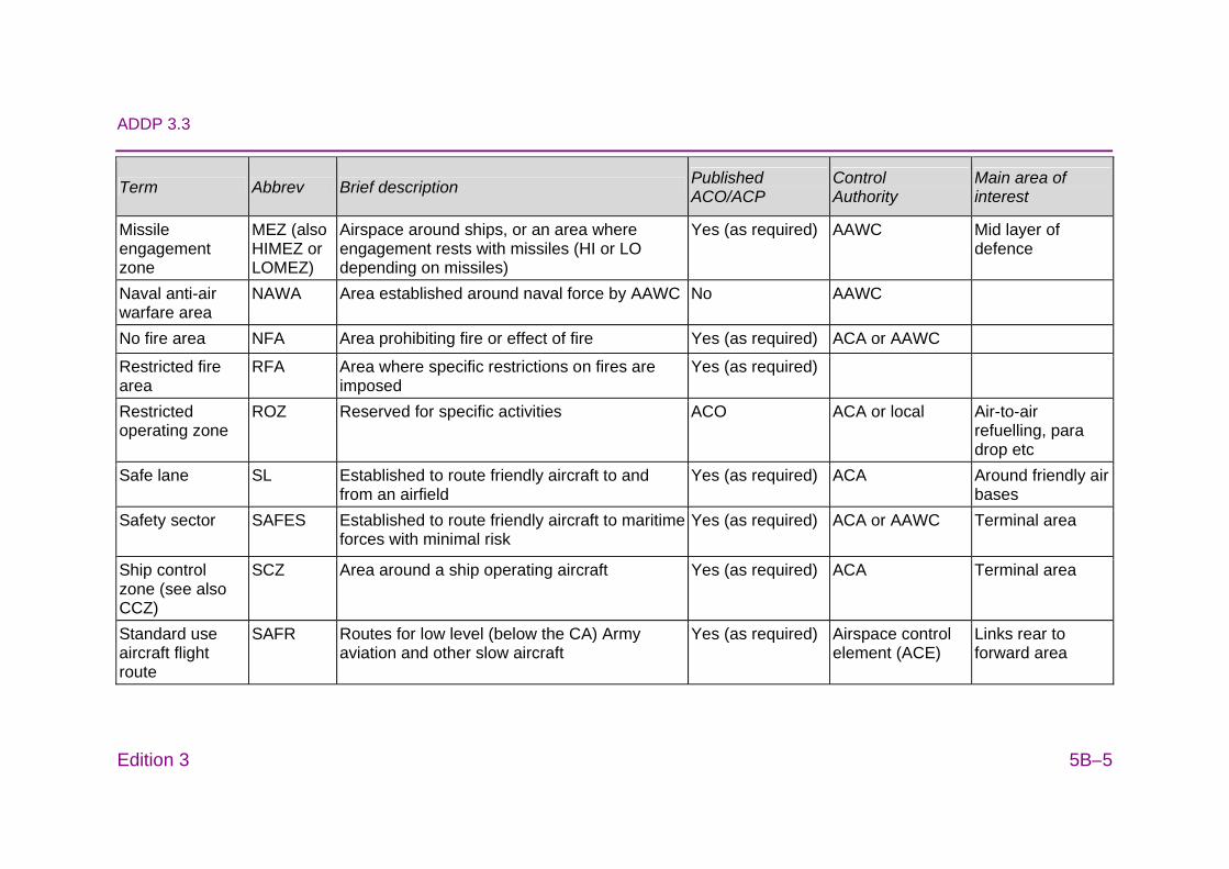
ADDP 3.3
Edition 3 5B–5
Term Abbrev Brief description Published ACO/ACP
Control Authority
Main area of interest
Missile engagement zone
MEZ (also HIMEZ or LOMEZ)
Airspace around ships, or an area where engagement rests with missiles (HI or LO depending on missiles)
Yes (as required) AAWC Mid layer of defence
Naval anti-air warfare area
NAWA Area established around naval force by AAWC No AAWC
No fire area NFA Area prohibiting fire or effect of fire Yes (as required) ACA or AAWC
Restricted fire area
RFA Area where specific restrictions on fires are imposed
Yes (as required)
Restricted operating zone
ROZ Reserved for specific activities ACO ACA or local Air-to-air refuelling, para drop etc
Safe lane SL
Established to route friendly aircraft to and from an airfield
Yes (as required) ACA Around friendly air bases
Safety sector SAFES Established to route friendly aircraft to maritime forces with minimal risk
Yes (as required) ACA or AAWC Terminal area
Ship control zone (see also CCZ)
SCZ Area around a ship operating aircraft Yes (as required) ACA Terminal area
Standard use aircraft flight route
SAFR Routes for low level (below the CA) Army aviation and other slow aircraft
Yes (as required) Airspace control element (ACE)
Links rear to forward area
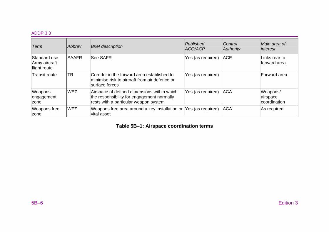
ADDP 3.3
5B–6 Edition 3
Term Abbrev Brief description Published ACO/ACP
Control Authority
Main area of interest
Standard use Army aircraft flight route
SAAFR See SAFR Yes (as required) ACE Links rear to forward area
Transit route TR Corridor in the forward area established to minimise risk to aircraft from air defence or surface forces
Yes (as required) Forward area
Weapons engagement zone
WEZ Airspace of defined dimensions within which the responsibility for engagement normally rests with a particular weapon system
Yes (as required) ACA Weapons/ airspace coordination
Weapons free zone
WFZ Weapons free area around a key installation or vital asset
Yes (as required) ACA As required
Table 5B–1: Airspace coordination terms
ADDP 3.3 ANNEX C TO
CHAPTER 5
Edition 3 5C–1
AIRBORNE RADIO PROCEDURES
1. All aircraft will check in and out with the assigned command and control (C2) agency in accordance with the airspace control order or special instructions, or as advised by the controlling airborne early warning and control platform. Once an asset is authorised to proceed to a joint fires area (JFA), aircraft must check in with the JFA coordinator prior to entering the JFA or associated airspace. At a minimum, the C2 agency will advise the following JFA information:
a. airspace (Global Area Reference System (GARS) cells/quadrants/keys as applicable), including altitude levels;
b. effects area (in GARS coordinates);
c. effective time;
d. JFA status (active or cold);
e. JFA coordinator call sign (if applicable);
f. frequency;
g. target description and priorities;
h. desired effects;
i. restrictive fire support coordination measures (FSCM); and
j. threats.
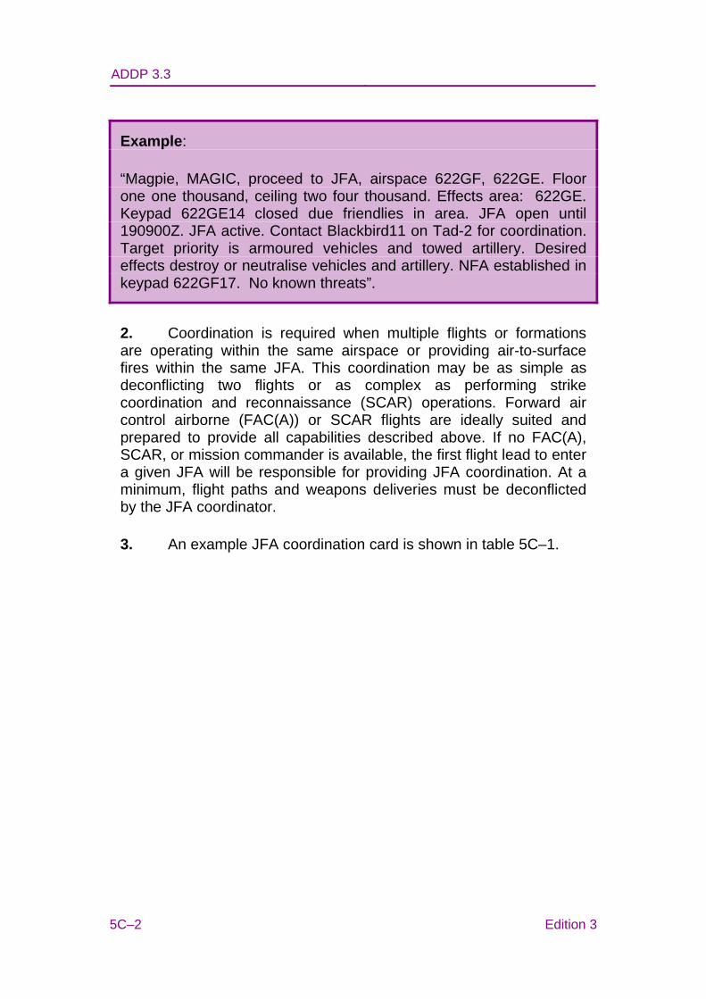
ADDP 3.3
5C–2 Edition 3
Example:
“Magpie, MAGIC, proceed to JFA, airspace 622GF, 622GE. Floor one one thousand, ceiling two four thousand. Effects area: 622GE. Keypad 622GE14 closed due friendlies in area. JFA open until 190900Z. JFA active. Contact Blackbird11 on Tad-2 for coordination. Target priority is armoured vehicles and towed artillery. Desired effects destroy or neutralise vehicles and artillery. NFA established in keypad 622GF17. No known threats”.
2. Coordination is required when multiple flights or formations are operating within the same airspace or providing air-to-surface fires within the same JFA. This coordination may be as simple as deconflicting two flights or as complex as performing strike coordination and reconnaissance (SCAR) operations. Forward air control airborne (FAC(A)) or SCAR flights are ideally suited and prepared to provide all capabilities described above. If no FAC(A), SCAR, or mission commander is available, the first flight lead to enter a given JFA will be responsible for providing JFA coordination. At a minimum, flight paths and weapons deliveries must be deconflicted by the JFA coordinator.
3. An example JFA coordination card is shown in table 5C–1.

ADDP 3.3
Edition 3 5C–3
Aircrew JFA Coordination Card JFA number JF001ACC JFA status Active/cold Airspace Location:
Floor: Ceiling:
Effects area(s) Open: Closed:
Effective times Start: End:
Restrictive FCSM eg restricted or no fire areas JFA coordinator Call sign: Frequency Target description and priorities
Threats Remarks
Table 5C–1: Aircrew joint fires area coordination card
4. Once a flight is cleared into the assigned JFA, and deconfliction within the lateral and vertical boundaries of the JFA airspace is established and ensured, the flight is cleared to manoeuvre as required for ordnance delivery in accordance with the rules of engagement.
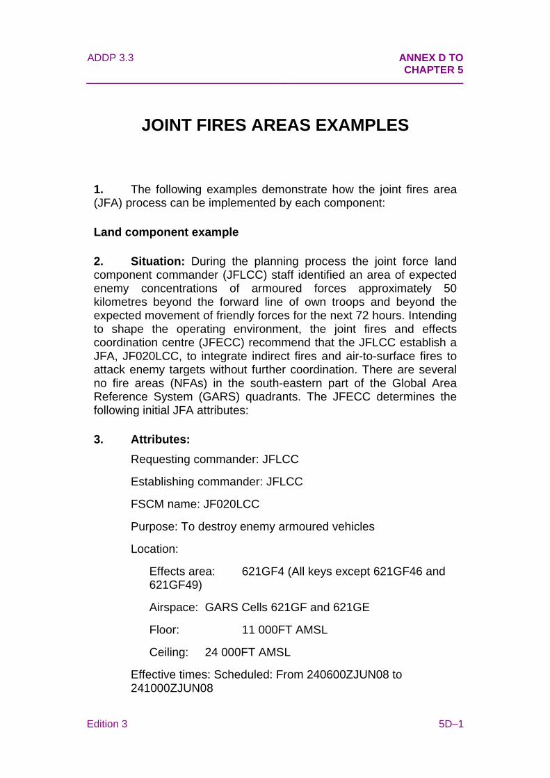
ADDP 3.3 ANNEX D TO
CHAPTER 5
Edition 3 5D–1
JOINT FIRES AREAS EXAMPLES
1. The following examples demonstrate how the joint fires area (JFA) process can be implemented by each component:
Land component example
2. Situation: During the planning process the joint force land component commander (JFLCC) staff identified an area of expected enemy concentrations of armoured forces approximately 50 kilometres beyond the forward line of own troops and beyond the expected movement of friendly forces for the next 72 hours. Intending to shape the operating environment, the joint fires and effects coordination centre (JFECC) recommend that the JFLCC establish a JFA, JF020LCC, to integrate indirect fires and air-to-surface fires to attack enemy targets without further coordination. There are several no fire areas (NFAs) in the south-eastern part of the Global Area Reference System (GARS) quadrants. The JFECC determines the following initial JFA attributes:
3. Attributes: Requesting commander: JFLCC
Establishing commander: JFLCC
FSCM name: JF020LCC
Purpose: To destroy enemy armoured vehicles
Location:
Effects area: 621GF4 (All keys except 621GF46 and 621GF49)
Airspace: GARS Cells 621GF and 621GE
Floor: 11 000FT AMSL
Ceiling: 24 000FT AMSL
Effective times: Scheduled: From 240600ZJUN08 to 241000ZJUN08

ADDP 3.3
5D–2 Edition 3
Target/priorities: Tanks, air defence artillery, and armoured vehicles
Effects: Destroy/neutralise
Restrictions: Do not destroy bridges or road networks
Fires deconfliction: Army artillery fire support 240600Z to 240630Z, air support from 240630Z to 241000Z
Control: SPADE TACP-ACE
Frequency: 123.45 Mhz
Remarks: NFA contained within 621GF46 and 621GF49 for Operational Detachment Alpha (ODA).
4. Key concepts: After determining the initial attributes and conducting coordination and deconfliction within the land component, airspace control authority, and other affected commanders, the JFA is established. For this example, the JFECC has used GARS 621GF and 621GE. Surface-to-surface indirect fires and air-to-surface fires have been deconflicted by time, although this may not necessarily be the case. In order to establish JF020LCC, the JFLCC will ensure all affected commanders have received the attributes for JF020LCC. Distribution of this information will be conducted through established fire support and command and control agencies.
Air component example
5. Situation. Intelligence, surveillance and reconnaissance (ISR) data has identified movement of an enemy armoured division in the joint force air component commander’s (JFACC’s) area of operation (AO). Based on rate of movement, the division is expected to reach the JFLCC’s AO in approximately 72 hours. The JFLCC has nominated the enemy armoured as a nominated target for inclusion on the joint integrated prioritised target list. The Air Operations Centre Combat Plans Division determines that a JFA should be established over the target area of interest, predicting the estimated target location based on rate of movement. The request for the JFA is built with the following information:
6. Attributes. Requesting commander: JFACC
Establishing commander: JFACC
ADDP 3.3
Edition 3 5D–3
FSCM Name: JF022ACC
Purpose: Destroy enemy armoured assets
Location:
Effects area: GARS cell 622GE (all except key 622GE14)
Airspace: GARS cells 622GE and 622GF
Floor: 15 000FT AMSL
Ceiling: 25 000FT AMSL
Effective times: 180600ZJUN08 to 192359ZJUN08
Target/priorities: Tanks, self-propelled and towed artillery, all other armour
Effects: Destroy/neutralise
Restrictions: Do not destroy bridges or road networks
Fires deconfliction: Not required—Air only
Control: ‘MAGIC’ (AEW&C)
Remarks: NFA at 622GE14 – ODA Team Bravo.
7. Key concepts. In the air tasking order (ATO), air interdiction and ISR assets were assigned with a mission location as JF022ACC. The effects area open to fires was specified for each mission in the mission amplification line. Control agency and frequency were also included in the ATO mission information. Early in the 36 hour period that JF022ACC was in effect, the air and space operations centre (AOC) was informed via the special operations liaison element (SOLE) that the special operations forces (SOF) team occupying key 622GE14 had vacated its position and the NFA established to protect the team was no longer necessary. As a result, the joint airspace control cell coordinated with all affected headquarters/agencies to adjust the effects area of JF022ACC to include keypad 622GE14. The message that 622GE14 is now open was passed to ‘MAGIC’ via secure voice/data link, who then passed the information to airborne tactical aircraft tasked to JF022ACC. The adjustment was disseminated in the next airspace control order (ACO) change. The information was also passed to combat plans, which made the appropriate modifications to the next day’s ATO and ACO.
ADDP 3.3
5D–4 Edition 3
Special forces example
8. Situation. A number of special operations teams are conducting reconnaissance within a joint special operations area, well forward of the fire support coordination line and beyond JFACC’s AO. The joint force special operations component commander (JFSOCC) is unable to provide advance coordination of accurate NFA, yet intends to employ joint fires against enemy armoured formations, with and without employing close air support (CAS). To provide the desired flexibility without increasing the risk of fratricide, JFSOCC requests a JFA with a large effects area that is in effect—closed, with the intention of making some or all of the effects area open—active at the discretion of the special operations patrol’s joint terminal air controller (JTAC). The request for the JFA is built with the following information:
9. Attributes. Requesting commander: JFSOCC
Establishing commander: JFSOCC
FSCM Name: JF024SOC
Purpose: Destroy enemy armoured assets
Location:
Effects area: GARS cell 623GE and 622GF
Airspace: GARS cells 622GE and 622GF
Floor: 15 000FT AMSL
Ceiling: 31 000FT AMSL
Effective times: 100300ZJUN08 to 261000ZJUN08
Target/priorities: Tanks, self-propelled and towed artillery, all other armour
Effects: Destroy
Restrictions: Do not destroy bridges or road networks
Fires deconfliction: Not required
Control: ‘DAGGER’ (JTAC) on TAD 4
Remarks: NFA to be advised by JTAC.
ADDP 3.3
Edition 3 5D–5
10. Key concepts. A large effects area remains in effect—closed to permit the SOF patrols to manoeuvre as required without risk of fratricide. Once the aircraft enters the JFA, the JTAC provides accurate NFA details to protect each patrol. The AOC airspace manager (through the SOLE) manages the effects area by specifying the GARS keys that are open—active. The JTAC may also employ CAS by leaving closed some or all of the JFA, then directly coordinating air-to-surface fires. This JFA presents no restrictions for aircraft needing to transit the JFA airspace while the JFA is in effect—closed (aircraft may transit subject to conducting an ‘all stations’ call on the JFA frequency).
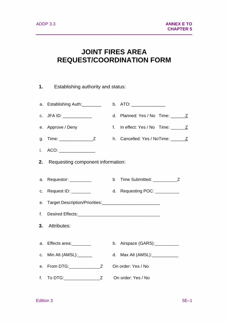
ADDP 3.3 ANNEX E TO
CHAPTER 5
Edition 3 5E–1
JOINT FIRES AREA REQUEST/COORDINATION FORM
1. Establishing authority and status:
a. Establishing Auth:________ b. ATO: ______________
c. JFA ID: ____________ d. Planned: Yes / No Time: ______Z
e. Approve / Deny f. In effect: Yes / No Time: ______Z
g. Time: ______________Z h. Cancelled: Yes / No Time: ______Z
i. ACO: _______________
2. Requesting component information:
a. Requestor: _________ b Time Submitted: __________Z
c. Request ID: ________ d. Requesting POC: __________
e. Target Description/Priorities:________________________
f. Desired Effects:__________________________________
3. Attributes:
a. Effects area:________ b. Airspace (GARS):__________
c. Min Alt (AMSL):______ d. Max Alt (AMSL):___________
e. From DTG:_____________Z On order: Yes / No
f. To DTG:_______________Z On order: Yes / No
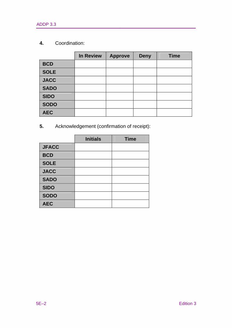
ADDP 3.3
5E–2 Edition 3
4. Coordination:
In Review Approve Deny Time BCD
SOLE
JACC
SADO
SIDO
SODO
AEC
5. Acknowledgement (confirmation of receipt):
Initials Time JFACC
BCD
SOLE
JACC
SADO
SIDO
SODO
AEC
ADDP 3.3 Chapter 6
Edition 3 6–1
CHAPTER 6
CONTROL AND COORDINATION PROCEDURES
Executive Summary
• Deconfliction reduces the risk of collision between aircraft and other airborne hazards by coordinating their movements in time or space.
• Positive and procedural control are methods of deconfliction.
• Only Joint Battlefield Airspace Control (JBAC) officers are authorised to provide separation between military and civilian aircraft.
• A non-JBAC qualified joint terminal attack controller (JTAC) can only segregate using procedural measures that do not require real time or near real time intervention.
• Unmanned aerial systems (UAS) impose unique demands on the airspace control systems, but can be safely and efficiently integrated into the airspace control system.
Introduction
6.1 Airspace control and coordination procedures should enable integration, coordination, adaptability and flexibility across the joint force. This will allow effective control of the airspace and ensure that maximum freedom of manoeuvre is available to friendly force airspace users.
6.2 Deconfliction of aircraft, airborne munitions and other airborne hazards enables maximum mission flexibility without compromising force preservation requirements.
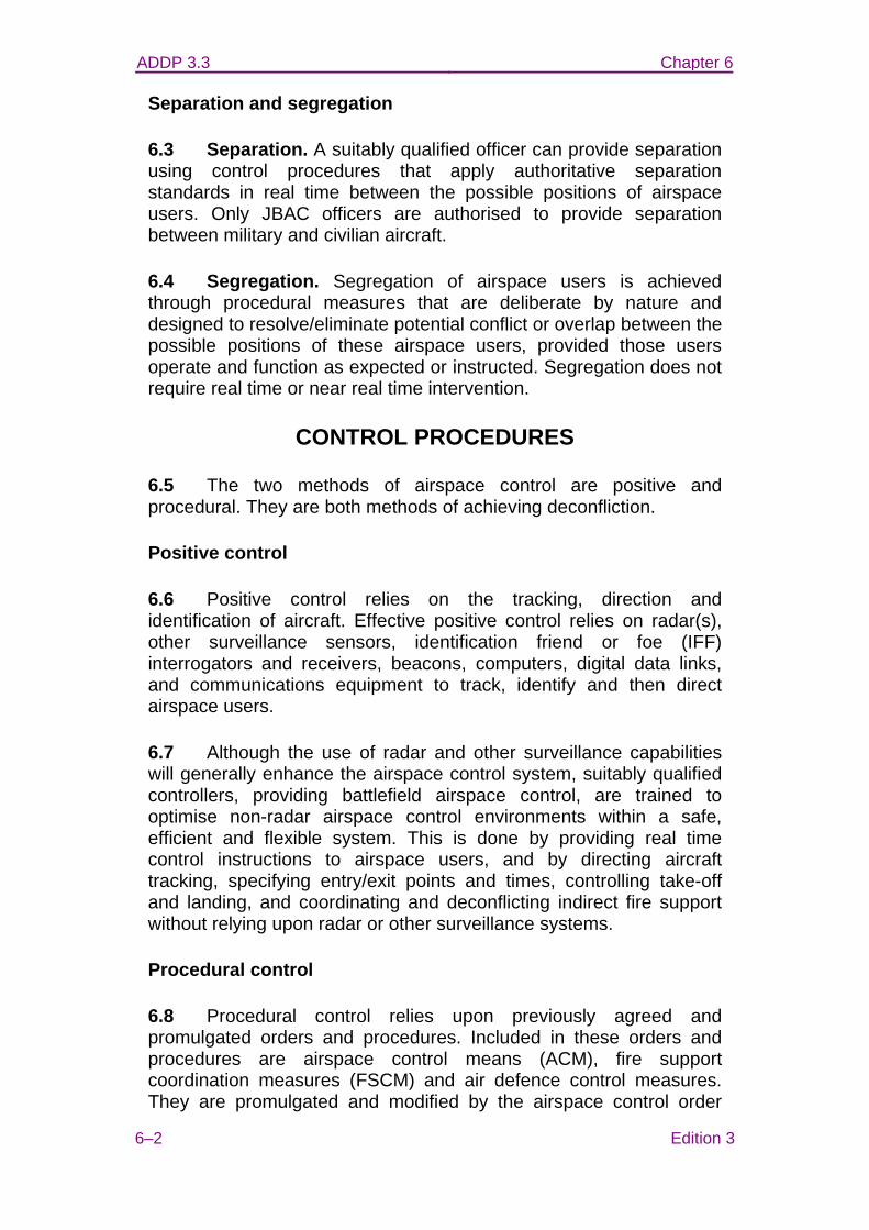
ADDP 3.3 Chapter 6
6–2 Edition 3
Separation and segregation
6.3 Separation. A suitably qualified officer can provide separation using control procedures that apply authoritative separation standards in real time between the possible positions of airspace users. Only JBAC officers are authorised to provide separation between military and civilian aircraft.
6.4 Segregation. Segregation of airspace users is achieved through procedural measures that are deliberate by nature and designed to resolve/eliminate potential conflict or overlap between the possible positions of these airspace users, provided those users operate and function as expected or instructed. Segregation does not require real time or near real time intervention.
CONTROL PROCEDURES
6.5 The two methods of airspace control are positive and procedural. They are both methods of achieving deconfliction.
Positive control
6.6 Positive control relies on the tracking, direction and identification of aircraft. Effective positive control relies on radar(s), other surveillance sensors, identification friend or foe (IFF) interrogators and receivers, beacons, computers, digital data links, and communications equipment to track, identify and then direct airspace users.
6.7 Although the use of radar and other surveillance capabilities will generally enhance the airspace control system, suitably qualified controllers, providing battlefield airspace control, are trained to optimise non-radar airspace control environments within a safe, efficient and flexible system. This is done by providing real time control instructions to airspace users, and by directing aircraft tracking, specifying entry/exit points and times, controlling take-off and landing, and coordinating and deconflicting indirect fire support without relying upon radar or other surveillance systems.
Procedural control
6.8 Procedural control relies upon previously agreed and promulgated orders and procedures. Included in these orders and procedures are airspace control means (ACM), fire support coordination measures (FSCM) and air defence control measures. They are promulgated and modified by the airspace control order
ADDP 3.3 Chapter 6
Edition 3 6–3
(ACO) and special instructions to allow airspace users free access to specified volumes of airspace, with published restrictions. Procedural control divides the airspace by volume and time, and uses airspace coordination measures and the status of weapons control to manage aviation operations. Procedural control can be executed by tasking an aircraft to follow a planned air route, with strict timings for passing each waypoint along a course, but with no real time communications or control of that aircraft.
6.9 Procedural control must not be confused with the International Civil Aviation Organisation (ICAO) term for air traffic control without using radar, which is also termed procedural. ICAO procedural control resembles non-radar positive control described in previous paragraphs.
Subordinate airspace control areas
6.10 The airspace control authority (ACA) may assign portions of the joint force area of operations (JFAO) to commanders for defined periods to allow them maximum operational freedom. Within these sub-areas, commanders may use positive or procedural control within the scope of the airspace control plan (ACP). This may be appropriate for large scale operations. The ACA should designate a subordinate airspace control authority (SACA) for each sub-area. Each SACA plans, coordinates and implements (in coordination with other commanders via input into the ACP and ACO) airspace control activities within their subordinate airspace control area. The ACA remains the ultimate authority for joint airspace control activities within the JFAO.
COORDINATION PROCEDURES
6.11 The ACP should emphasise coordination amongst airspace control agencies to minimise the burden on airspace users and enable them to concentrate on delivering effects. Due to buffers and tolerances, airspace boundaries can limit the achievement of desired effects and create potential fratricide issues unless airspace control agencies ensure efficient interagency coordination procedures.
6.12 In addition to ACM, airspace control agencies may employ various coordination procedures, including real time aircraft/airspace coordination, deconfliction and FSCM. The regional operations centre would facilitate and coordinate the movement of air assets within the JFAO airspace. Below the coordinating altitude and within an established ACM, combat control teams (CCT), JTAC and JBAC will
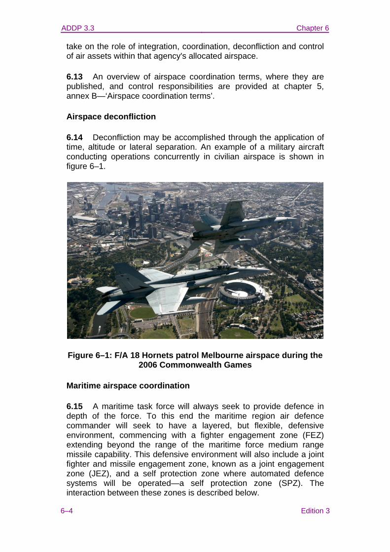
ADDP 3.3 Chapter 6
6–4 Edition 3
take on the role of integration, coordination, deconfliction and control of air assets within that agency's allocated airspace.
6.13 An overview of airspace coordination terms, where they are published, and control responsibilities are provided at chapter 5, annex B—‘Airspace coordination terms’.
Airspace deconfliction
6.14 Deconfliction may be accomplished through the application of time, altitude or lateral separation. An example of a military aircraft conducting operations concurrently in civilian airspace is shown in figure 6–1.
Figure 6–1: F/A 18 Hornets patrol Melbourne airspace during the 2006 Commonwealth Games
Maritime airspace coordination
6.15 A maritime task force will always seek to provide defence in depth of the force. To this end the maritime region air defence commander will seek to have a layered, but flexible, defensive environment, commencing with a fighter engagement zone (FEZ) extending beyond the range of the maritime force medium range missile capability. This defensive environment will also include a joint fighter and missile engagement zone, known as a joint engagement zone (JEZ), and a self protection zone where automated defence systems will be operated—a self protection zone (SPZ). The interaction between these zones is described below.
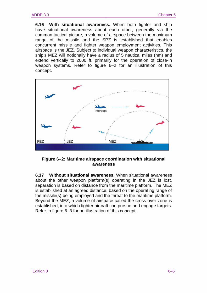
ADDP 3.3 Chapter 6
Edition 3 6–5
6.16 With situational awareness. When both fighter and ship have situational awareness about each other, generally via the common tactical picture, a volume of airspace between the maximum range of the missile and the SPZ is established that enables concurrent missile and fighter weapon employment activities. This airspace is the JEZ. Subject to individual weapon characteristics, the ship’s MEZ will notionally have a radius of 5 nautical miles (nm) and extend vertically to 2000 ft, primarily for the operation of close-in weapon systems. Refer to figure 6–2 for an illustration of this concept.
Figure 6–2: Maritime airspace coordination with situational awareness
6.17 Without situational awareness. When situational awareness about the other weapon platform(s) operating in the JEZ is lost, separation is based on distance from the maritime platform. The MEZ is established at an agreed distance, based on the operating range of the missile(s) being employed and the threat to the maritime platform. Beyond the MEZ, a volume of airspace called the cross over zone is established, into which fighter aircraft can pursue and engage targets. Refer to figure 6–3 for an illustration of this concept.
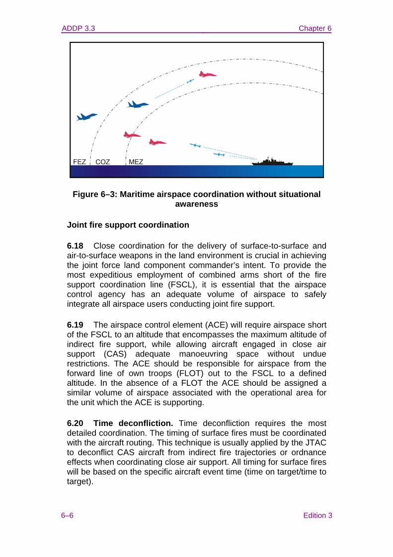
ADDP 3.3 Chapter 6
6–6 Edition 3
Figure 6–3: Maritime airspace coordination without situational awareness
Joint fire support coordination
6.18 Close coordination for the delivery of surface-to-surface and air-to-surface weapons in the land environment is crucial in achieving the joint force land component commander’s intent. To provide the most expeditious employment of combined arms short of the fire support coordination line (FSCL), it is essential that the airspace control agency has an adequate volume of airspace to safely integrate all airspace users conducting joint fire support.
6.19 The airspace control element (ACE) will require airspace short of the FSCL to an altitude that encompasses the maximum altitude of indirect fire support, while allowing aircraft engaged in close air support (CAS) adequate manoeuvring space without undue restrictions. The ACE should be responsible for airspace from the forward line of own troops (FLOT) out to the FSCL to a defined altitude. In the absence of a FLOT the ACE should be assigned a similar volume of airspace associated with the operational area for the unit which the ACE is supporting.
6.20 Time deconfliction. Time deconfliction requires the most detailed coordination. The timing of surface fires must be coordinated with the aircraft routing. This technique is usually applied by the JTAC to deconflict CAS aircraft from indirect fire trajectories or ordnance effects when coordinating close air support. All timing for surface fires will be based on the specific aircraft event time (time on target/time to target).

ADDP 3.3 Chapter 6
Edition 3 6–7
6.21 Lateral deconfliction. Lateral deconfliction ensures conflicting activities are separated, whilst allowing freedom of movement in the vertical plane. This is an appropriate technique when a firing unit is engaging a target, and aircraft that are not associated with the fires mission or under control of the ACE will cross or come in close proximity to the gun target line. It is also appropriate for other activities that require deconfliction but, due to the timing, have not had airspace reserved on the ACO (for example a short-notice UAS task). The horizontal buffer applied to achieve lateral deconfliction between activities should be two kilometres. While the deconfliction measure may be described by a universal transverse Mercator grid line or latitude/longitude reference, terrain features have the added advantages of simplicity and constant visual reference. For example: ‘stay west of the grid line 62’ or ‘remain west of the river’.
• In the example shown at figure 6–4, an aircraft is planned to track direct PEACH to PLUM. A fire mission is requested from the artillery unit 2E (located at grid KA 318 045) to engage a target (located at grid KV 305 985). To ensure lateral deconfliction and provide clear air for the fire mission, the gun target line is plotted and a two kilometre buffer is applied. The aircraft is tracked around the plotted area, in this case tracking visually via point MANGO.
• To ensure lateral deconfliction exists between a restricted operating zone (ROZ) and other airspace users, the lateral deconfliction buffer should be built into the ROZ.

ADDP 3.3 Chapter 6
6–8 Edition 3
Figure 6–4: Lateral deconfliction
6.22 Altitude deconfliction. Altitude deconfliction permits multiple activities within similar lateral confines to occur. For example, indirect fire is able to safely continue whilst aircraft are operating above the airspace required for fire support. Deconfliction from the indirect fire trajectory and fragmentation pattern is provided by ‘lowest usable level’ or ‘highest usable level’. The highest point of a trajectory for any given fire mission is referred to as the maximum ordinate (MAXORD), The lowest point is known as the minimum ordinate (MINORD). Because of the parabolic trajectories involved with indirect fires, it is important that aircrew know the location(s) of indirect fire weapons systems, the relevant gun target line and the lateral limits at which it is safe to transit under a given trajectory. When calculating a safe deconfliction altitude for an aircraft to stay above or below the MAXORD, the ACE shall apply a safety margin to the MAXORD. This margin is usually 1000 feet above the MAXORD or, if below the MINORD, the lateral flight limits will clear the flanks of the parabolic trajectory by at least the same safety margin. In instances where aircraft are not operating on the local barometric pressure, an additional pressure variation buffer of 1000 feet should be applied. (see figure 6–5). To ensure altitude deconfliction exists between a ROZ and other airspace users, the vertical deconfliction buffer should be built in to the ROZ.
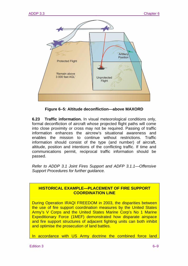
ADDP 3.3 Chapter 6
Edition 3 6–9
Figure 6–5: Altitude deconfliction—above MAXORD
6.23 Traffic information. In visual meteorological conditions only, formal deconfliction of aircraft whose projected flight paths will come into close proximity or cross may not be required. Passing of traffic information enhances the aircrew’s situational awareness and enables the mission to continue without restrictions. Traffic information should consist of the type (and number) of aircraft, altitude, position and intentions of the conflicting traffic. If time and communications permit, reciprocal traffic information should be passed.
Refer to ADDP 3.1 Joint Fires Support and ADFP 3.1.1—Offensive Support Procedures for further guidance.
HISTORICAL EXAMPLE—PLACEMENT OF FIRE SUPPORT COORDINATION LINE
During Operation IRAQI FREEDOM in 2003, the disparities between the use of fire support coordination measures by the United States Army’s V Corps and the United States Marine Corp’s No 1 Marine Expeditionary Force (1MEF) demonstrated how disparate airspace and fire support structures of adjacent fighting units can both inhibit and optimise the prosecution of land battles.
In accordance with US Army doctrine the combined force land
ADDP 3.3 Chapter 6
6–10 Edition 3
component commander established a large surface area of operations and placed the FSCL for both land forces approximately 130 kilometres ahead of the FLOT. The V Corps commander closed most of the kill boxes1 between the FLOT and the FSCL. The intent of this was to shape the operating environment using organic Army deep strike assets (Apache Longbow AH-64 helicopters and Army Tactical Missile Systems).
However, V Corps’ organic deep strike assets could not by themselves support the shaping plan, and so V Corp also used large numbers of fixed-wing strike aircraft for CAS and interdiction. Unfortunately, the very large distance from the FLOT to the FSCL and the paucity of open kill boxes meant that CAS, reliant upon limited numbers of JTAC, was the primary method of prosecuting targets.
The result was an ineffective and inefficient use of fixed-wing aircraft. The aircraft spent extended periods holding in CAS stacks, only to return to base having not expended their ordnance, despite ample adversary targets existing in the safe-haven inadvertently created between the FLOT and the FSCL.
In contrast, the 1MEF established a battlefield coordination line (BCL) that was approximately 20–30 kilometres (the maximum range of 1 MEF’s organic artillery) ahead of the FLOT, and kept open most of the kill boxes between the BCL and the FSCL. This left 1MEF with adequate JTAC capability to service the area between the FLOT and BCL, and interdiction could be conducted in the open kill boxes beyond the BCL to the FSCL.
Frequently, coalition aircraft that were tasked to support V Corps would wait unutilised in CAS stacks, due to insufficient JTAC to properly service the large area between the FLOT and the FSCL. Then, with approximately 15 minutes holding fuel remaining, those coalition aircraft would return to base via 1MEF’s area of operations and immediately be assigned either CAS or air interdiction targets.
By structuring their joint fire support coordination as they did, 1MEF provided a flexible, efficient environment for effects to be brought to bear on the adversary, thereby allowing 1MEF to more effectively meet the joint task force commander’s mission and intent.
1 Kill box was a term used to describe a joint force coordination measure employed for air-ground fires during Operation IRAQI FREEDOM.
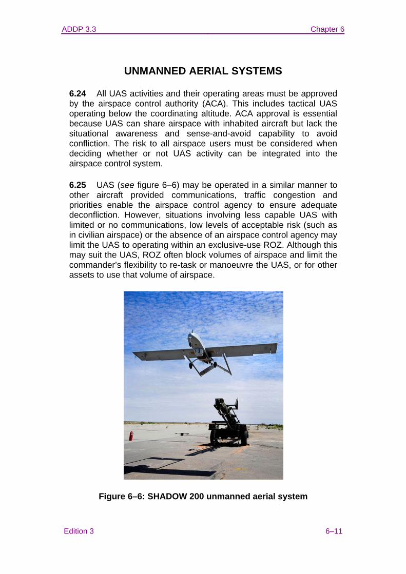
ADDP 3.3 Chapter 6
Edition 3 6–11
UNMANNED AERIAL SYSTEMS
6.24 All UAS activities and their operating areas must be approved by the airspace control authority (ACA). This includes tactical UAS operating below the coordinating altitude. ACA approval is essential because UAS can share airspace with inhabited aircraft but lack the situational awareness and sense-and-avoid capability to avoid confliction. The risk to all airspace users must be considered when deciding whether or not UAS activity can be integrated into the airspace control system.
6.25 UAS (see figure 6–6) may be operated in a similar manner to other aircraft provided communications, traffic congestion and priorities enable the airspace control agency to ensure adequate deconfliction. However, situations involving less capable UAS with limited or no communications, low levels of acceptable risk (such as in civilian airspace) or the absence of an airspace control agency may limit the UAS to operating within an exclusive-use ROZ. Although this may suit the UAS, ROZ often block volumes of airspace and limit the commander’s flexibility to re-task or manoeuvre the UAS, or for other assets to use that volume of airspace.
Figure 6–6: SHADOW 200 unmanned aerial system

ADDP 3.3 Chapter 6
6–12 Edition 3
6.26 Procedures for integrating UAS must be specified in the ACP. These should include:
• applicable aircraft information, including call sign, type, size, weight, operating altitude, speed, endurance, visible markings/lighting;
• launch and recovery sites and operating areas, including manoeuvring dimensions and whether the air vehicle will be within visual line-of-site or beyond visual line-of-site of the UAS ground control station;
• airworthiness certification, including civilian certificate of approval if applicable;
• navigation tolerances, having regard for altimetry, turbulence, crosswind and time of day/night;
• communications with airspace control agencies and other airspace users, including redundant/alternate means;
• lost-link and other emergency procedures, including requirement to report inability to comply with airspace limits or instructions from airspace control agency;
• IFF procedures, if applicable;
• coordination procedures for requesting airspace, if applicable;
• step-by-step coordination, communication and reporting procedures for conducting flights; and
• priority of the UAS compared to other airspace users.
6.27 Segregated airspace. When the necessity of the operating environment or compatibility of the UAS favours segregated airspace for UAS activities, the airspace control system should support the creation of several ACM to be used by the UAS and avoided by other airspace users while active. If necessary to enable greater flexibility for other airspace users, these ACM should be activated sequentially, based upon actual requests and reports from the UAS operator to the airspace control agency.
6.28 Launch and recovery. The launch, transition to/from altitude and recovery may be facilitated by establishing a ROZ around the

ADDP 3.3 Chapter 6
Edition 3 6–13
UAS launch and recovery system (LRS). These ROZ are usually 1–2 nm in diameter but vary according to the characteristics of the UAS. The activation period of a UAS ROZ should be managed to minimise disruption to other airspace users. Larger UAS may operate from a runway/platform and be integrated with other air traffic movements.
6.29 En route. To facilitate transit to and from the UAS mission area, flight routes and transit altitudes (see figure 6–7) may be established, based on mission requirements and in accordance with the ACP. The en route airspace must contain the UAS lateral and vertical tolerances plus the applicable lateral and vertical separation standards. This is to ensure that other airspace users operating at the boundary of the UAS flight route or blanket are separated from the UAS (including all navigation tolerances).
6.30 Mission area. In the mission area, a ROZ or airspace coordination area is used to isolate the UAS from other airspace users. Upon completion of the mission, the UAS returns to the LRS using the en route procedures previously described.
Figure 6–7: Unmanned aerial system aircraft flight profile
ADDP 3.3
Edition 3
GLOSSARY
The source for approved Defence terms, definitions and abbreviations is the Australian Defence Glossary (ADG), available on the Defence Restricted Network at http://adg.eas.defence.mil.au/adgms/. Note: the ADG is updated regularly and should be checked for amendments to the entries in this glossary.
air battle management. Control of military air operations that may include the control and coordination of defensive counter air, offensive counter air, strategic attack, offensive air support and other war fighting or supporting air activities.
air corridor A restricted air route of travel specified for use by friendly aircraft and established for the purpose of preventing friendly aircraft from being fired on by friendly forces.
air defence identification zone Airspace of defined dimensions within which the ready identification, location and control of aircraft is required.
airborne early warning and control Air surveillance and control provided by airborne early warning aircraft which are equipped with search and height-finding radar and communications equipment for controlling weapons.
air route The navigable airspace between two points, identified to the extent necessary for the application of flight rules.
airspace The zone next to the earth consisting of atmosphere capable of sustaining flight.
airspace control The real-time or near real-time implementation of the airspace management procedures governing airspace usage in order to mitigate risk and enhance the flexible use of airspace.
ADDP 3.3
Edition 3
airspace control area Airspace which is laterally defined by the boundaries of the area of operations. The airspace control area may be subdivided into airspace control sub-areas
airspace control authority The commander designated to assume overall responsibility for the operation of the airspace control system in his or her assigned area.
airspace control means Measures that promote the safe, efficient and flexible use of airspace
airspace control order The document providing specific information on airspace control and airspace control measures.
airspace control plan The document providing specific planning guidance and procedures for the airspace control system.
airspace control procedures Rules, mechanisms, and directions that facilitate the control and use of airspace of specified dimensions.
airspace control sector A sub-element of the airspace control area, established to facilitate the control of the overall area. Airspace control sector boundaries normally coincide with air defence organisation subdivision boundaries. Airspace control sectors are designated in accordance with procedures and guidance contained in the airspace control plan in consideration of Service component, host nation, and multinational airspace control capabilities and requirements.
airspace control system An arrangement of those organisations, personnel, policies, procedures and facilities required to perform airspace control functions.
airspace coordination area In fire support operations, a restrictive fire support coordination measure that establishes a volume of airspace in the target area within which friendly aircraft are reasonably safe from friendly surface fire.
ADDP 3.3
Edition 3
airspace management The coordination, integration, and regulation of the use of airspace of defined dimensions.
air support operations centre An agency of the theatre air control system collocated with a land force headquarters, which coordinates and directs close air support and other tactical air support.
air traffic control services A service provided for the purpose of: a. preventing collisions: (1) between aircraft; and (2) on the manoeuvring area between aircraft and obstructions; and b. expediting and maintaining an orderly flow of air traffic.
altitude The vertical distance of a level, a point or object considered as a point, measured from mean sea level.
amphibious objective area A geographical area, delineated in the initiating directive, for purposes of command and control within which is located the objective(s) to be secured by the amphibious task force. This area must be of sufficient size to ensure accomplishment of the amphibious task force’s mission and must provide sufficient area for conducting necessary sea, air and land operations.
area of operations An operational area defined by a joint commander for land or maritime forces to conduct military activities. Normally, an area of operations does not encompass the entire joint operations area of the joint commander, but is sufficient in size for the joint force component commander to accomplish assigned missions and protect forces.
base defence zone A zone established around airbases to enhance the effectiveness of local ground-based air defence systems.
battlefield airspace control. An airspace control service provided to promote the safe, efficient and flexible use of airspace within a tactical area of responsibility in support of the scheme of manoeuvre.

ADDP 3.3
Edition 3
combat controller Air Force personnel responsible for the tactical integration and synchronisation of airpower with ADF assets undertaking surface actions including maritime forces and littoral operations.
control of the air The ability to conduct friendly air operations and on the surface below it without interference from adversary airpower.
coordinating altitude A procedural airspace control method to separate fixed- and rotary-wing aircraft by determining an altitude below which fixed-wing aircraft will normally not fly and above which rotary-wing aircraft normally will not fly. The coordinating altitude is normally specified in the airspace control plan and may include a buffer zone for small altitude deviations.
deconfliction The act of reducing the risk of collision between aircraft and other airborne hazards by coordinating their movements in time or space.
fighter engagement zone A volume of airspace within which the responsibility for the engagement of air threats normally rests with fighter aircraft.
fire support coordination line Within an assigned area of operations, a line established by a land or amphibious force commander to denote coordination requirements for fires by other force elements which may affect the commander's current and planned operations. The fire support coordination line applies to fires of air, ground or sea weapons using any type of ammunition against surface or ground targets. The establishment of the fire support coordination line must be coordinated with the appropriate commanders and supporting elements. Attacks against surface or ground targets short of the fire support coordination line must be conducted under the positive control or procedural clearance of the associated land or amphibious force commander. Unless in exceptional circumstances, commanders of forces attacking targets beyond the fire support coordination line must coordinate with all affected commanders in order to avoid fratricide and to harmonise joint objectives.
ADDP 3.3
Edition 3
Note: in the context of this definition the term 'surface targets' applies to those in littoral or inland waters within the designated area of operations.
forward line of own troops A line which indicates the most forward positions of friendly forces in any kind of military operation at a specific time.
ground based air defence Land based surface to air weapons systems designed to defeat or reduce the effectiveness of hostile air action. Weapon systems may comprise guided weapons, anti-aircraft artillery or non-lethal weapons, and integral surveillance and target acquisition devices.
high density airspace control zone Airspace of defined dimensions, designated by the airspace control authority, in which there is a concentrated employment of numerous and varied weapons/airspace users.
Identification, friend or foe A system using electromagnetic transmissions to which equipment carried by friendly forces automatically responds, for example, by emitting pulses, thereby distinguishing themselves from enemy forces.
joint fires and effects coordination centre A single location within a joint force headquarters in which are centralised all communications facilities and personnel for the coordination and administration of all forms of offensive support.
joint force A general term applied to a force composed of significant elements of the Navy, Army and Air Force, or two or more of these Services, operating under a single joint force commander.
joint terminal attack controller A qualified (certified) Service member who, from a forward position, directs the action of combat aircraft engaged in close air support and other offensive air operations. A qualified and current joint terminal attack controller will be recognised across the Department of Defence as capable and authorised to perform terminal attack control.
ADDP 3.3
Edition 3
minimum risk route A temporary corridor of defined dimensions recommended for use by high-speed, fixed-wing aircraft that presents the minimum known hazards to low-flying aircraft transiting the combat zone.
mobile air operations team Royal Australian Air Force teams in the forward area who may assist in the selection and preparation of helicopter landing sites and forward airstrips, and control of aircraft at selected landing sites or airstrips.
operation A designated military activity using lethal and/or nonlethal ways and means to achieve directed outcomes in accordance with national legal obligations and constraints.
remotely piloted aircraft A powered, aerial vehicle that does not carry a human operator, uses aerodynamic forces to provide lift, can fly autonomously or be remotely piloted, can be expendable or recoverable, and can carry a lethal or non-lethal payload.
safe lane Specified air corridors designated for use in transit by aircraft to prevent attack by friendly forces.
segregate A deliberate procedural measure designed to resolve/eliminate potential conflict or overlap between the possible positions of airspace users, provided those users operate and function as expected or instructed.
separate The application, by appropriately trained and endorsed personnel, of authoritative separation standards in real time between the possible positions of aircraft.
ship control zone A localised volume of airspace around a ship which is operating aircraft.
standard use aircraft flight route Routes established below the coordinating altitude to facilitate the movement of aviation assets.
ADDP 3.3
Edition 3
tactical air control party An agency of the theatre air control system designed to support air operations within a tactical area of responsibility.
unmanned aerial system A system that encompasses one or more remotely piloted aircraft, the launch and recovery system,, the command, control and communications system, the ground controller and the information it disseminates.
ADDP 3.3
Edition 3
ABBREVIATIONS
AAA anti-aircraft artillery AAR air-to-air refuelling AAW anti-air warfare AAWC anti-air warfare commander ABM air battle management ABP air battle plan ACA airspace control authority ACC air component commander ACCE Air Component Coordination Element ACE Airspace Coordination Element ACM airspace control means ACMREQ airspace control means request ACO Airspace Control Order ACP Airspace Control Plan ACP air control point ADDP Australian Defence Doctrine Publication ADF Australian Defence Force ADFP Australian Defence Force Publication ADIZ air defence identification zone AEC Air Effects Cell AEW&C airborne early warning and control AGA air-ground-air AGL above ground level AIP aeronautical information publication AIRRTE air route AM amplitude modulation AMACE amphibious mobile airspace coordination
element AMSL above mean sea level AO area of operations AOA amphibious objective area AOC air and space operations centre AOD Air Operations Directive AOP Air Operations Plan APPCOR approach corridor AR air route ARH armed reconnaissance helicopter AsA Airservices Australia ASCA airspace coordination area ATC air traffic control ATF amphibious task force ATO air tasking order ATS air traffic service
ADDP 3.3
Edition 3
ATZ air traffic zone AUG air user group BAC battlefield airspace control BCD battlefield coordination detachment BCL battlefield coordination line BDZ base defence zone C2 command and control C2DO command and control duty officer CA coordinating altitude CAF Chief of Air Force CAP combat air patrol CAS close air support CASEVAC casualty evacuation CATF commander amphibious task force CCP communication check point CCZONE carrier control zone CDRAIR commander air CGRS common geographic reference system CIS communication and information systems CJOPS Chief of Joint Operations CJTF Commander Joint Task Force COP common operational picture COZ cross over zone CP contact point CRC Control and Reporting Centre CSAR combat search and rescue CTP common tactical picture DABATS deployed airbase air traffic service DGACOPS Director General Air Command Operations DGAIR Director General Air DSN defence secret network EG entry/exit gate FARP forward arming and refuelling point FEZ fighter engagement zone FFA free fire area FLOT forward line of own troops FSCL fire support coordination line FSCM fire support coordination measure FUA flexible use airspace GARS global area reference system GBAD ground-based air defence
ADDP 3.3
Edition 3
HF high frequency HG hand-over gate HIDACZ high-density airspace control zone HIMEZ high missile engagement zone HQ headquarters HQJOC Headquarters Joint Operations Command ICAO International Civil Aviation Organization ID identification IFF identification, friend or foe IMC instrument meteorological conditions IP initial point ISR identification safety range ISR intelligence, surveillance and reconnaissance JACC joint airspace control cell JAOG Joint Air Operations Guide JBAC joint battlefield airspace control JEZ joint engagement zone JFA joint fires areas JFACC Joint Force Air Component Commander JFAM joint fires areas manager JFAO joint force area of operations JFECC Joint Fires and Effects Coordination Centre JFLCC Joint Force Land Component Commander JFSOCC Joint Force Special Operations Component
Commander JFO joint fires officer JFT joint fires team JIPCL joint integrated prioritised collection list JIPTL joint integrated prioritised target list JMAP joint military appreciation process JSOA joint special operations area JTAC joint terminal attack controller JTF joint task force LCC land component command(er) LHD amphibious assault ship (dock) LOMEZ low missile engagement zone LRS launch and recovery site MAAP master air activity plan MACE mobile airspace coordination element MAOT mobile air operations team MATS maritime air traffic service MAXORD maximum ordinate
ADDP 3.3
Edition 3
MEZ missile engagement zone MINORD minimum ordinate MISARC missile arc MISREP mission report MOA memorandum/memoranda of agreement MRADC Maritime Regional Air Defence Commander MROC mobile regional operations centre MRR minimum-risk route NALE naval air liaison element NAWA naval anti-air warfare area NFA no fire area nm nautical mile NOTAM notice to airmen ODA operational detachment-Alpha OPORD operation order OPLAN operation plan OPSEC operations security POC point of contact RAAF Royal Australian Air Force RADC regional air defence commander RFA restricted fire area ROC regional operations centre ROZ restricted operating zone RPA remotely piloted aircraft SACA subordinate airspace control authority SACC Supporting Arms Coordination Centre SADO senior air defence officer SAFES safety sector SAFR standard use aircraft flight route SAAFR standard use army aircraft flight route SAR search and rescue SCAR strike coordination and reconnaissance SCZ ship control zone SIDO senior intelligence duty officer SIF selective identification feature SL Safe lane SODO senior offensive duty officer SOF special operations forces SOLE special operations liaison element SPINS special instructions TACP tactical air control party

ADDP 3.3
Edition 3
TACS theatre air control system TBMCS theatre battle management core system TET targeting effects team TG task group TNL target nomination list TR transit route UAS unmanned aerial system(s) UHF ultra high frequency UN United Nations VHF very high frequency VMC visual meteorological conditions VMF variable message format WEZ weapon engagement zone WFZ weapons free zone