ops summer 13 - aols | the association of ontario land …dev.aols.org/sites/default/files/ops...
TRANSCRIPT

ONTARIO PROFESSIONAL SURVEYORVOLUME 57, No. 2 Spring 2014
Professional Surveying
inOntario
encompasses the
Disciplines of
CadastrCadastral,al,GeodeticGeodetic ,,
HydrHydroogrgraphicaphic ,,PhotoPhotogrgrammetricammetric
SurvSurveyingeying&&
GeoGeogrgraphicaphicInfInformationormationManaManaggementement
CONTENTSOntario Digital Cadastre Corporation Vision and Mission - Brian Maloney........4Boundary principles: You come at the king, you best not miss -
Brian Ballantyne ..................................................................................................8Eighth Annual AOLS Graduate Student Geomatics Poster Session Award
Winners ...............................................................................................................14Continuing Education Committee (CEC) Update - Paul Church ........................16Convocation Address - Mark Tulloch...................................................................18122nd Annual General Meeting – Photos: Royal Dream Photography ..............20Annual General Meeting - Exhibitors and Veterans’ Dinner ..............................22DATA and GIS - Barry Costello ..........................................................................24Townships Named For Surveyors (Part 2) - Allan Day .......................................28Ontario One Call: Working to protect our underground infrastructure - Elena Pilavakis ...................................................................................................36
REGULAR FEATURESPresident’s Page .....................................................................................................2Calendar of Events ..............................................................................................16Sites to See ..........................................................................................................19News from 1043 ............................................................................................27, 34Educational Foundation .......................................................................................32Book Reviews .....................................................................................................39The Last Word - Major-General Sir Isaac Brock................................................40
ADVERTISERSSokkia ...................................................................................................... 2nd coverTopcon Positioning.................................................................................................3Cansel .....................................................................................................................5Hayward Iron & Metal ...........................................................................................6Northway/Photomap/Remote Sensing Ltd. ...........................................................7GeoShack Canada ................................................................................................11Dias & Dias ..........................................................................................................12Mark IT Locates...................................................................................................13Tekmet Ltd. .........................................................................................................17The Connectors Insurance Group Ltd. ................................................................25J.P. Morasse Inc. ..................................................................................................27Teranet Inc. ..........................................................................................................29T2 Utility Engineers.............................................................................................31DW Technologies..................................................................................................33Hunt Surveys Inc. ................................................................................................34The CG&B Group ................................................................................................35Leica Geosystems Ltd. ........................................................................................37Surv.ca ..................................................................................................................38Trimble ..................................................................................................... 3rd coverMicroSurvey Software Inc. ......................................................................4th cover
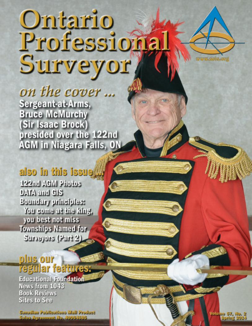
ON THE COVER ...Sergeant-at-Arms, Bruce McMurchy chose to depict Major-General Sir IsaacBrock because Queenston Heights and Lundy’s Lane, two of the battlefields in theWar of 1812, are close to Niagara Falls and because he has a family connection.Bruce’s grandmother Ostrander was the granddaughter of Jane Ostrander whoseoldest son, an aide-de-camp to Brock, assisted in removing his slain body from thebattlefield at Queenston Heights. Read about Major-General Sir Isaac Brock –“The Hero of Upper Canada” in The Last Word on page 40.
Ontario Professional Surveyor, Spring 2014 1

2 Ontario Professional Surveyor, Spring 2014
President’s PageBy Dasha Page, Hon. B.Sc., O.L.S.
First and foremost, I amboth humbled and privileged
to have the opportunity to serveas President of the Association of
Ontario Land Surveyors. I appre-ciate your faith and promise to do my
best to make this a successful year. We are only as good as those around us, and I am very
grateful to be working with the very dedicated Council andAOLS staff. Our successful Annual General Meeting (AGM) inNiagara Falls is a testament to their hard work and commitment.
I would like to thank all of you who joined us at ourPresident’s Luncheon on Friday at our AGM. I was quitemoved and honoured by your tremendous support.
My gratitude extends also to my family as without theirsupport and understanding, I would not be able to serve oncouncil.
Lastly, I would like to extend my appreciation to mycolleagues at Matthews, Cameron, Heywood – Kerry T. HoweSurveying Ltd. in Niagara Falls and our sister company at CoeFisher Cameron in Lindsay. Their support makes my presiden-tial tenure possible.
Our Past President, Eric Ansell has led our associationforward by his vision, foresight, ethics and integrity. He gener-ated the perfect momentum to continue moving this greatassociation in the right direction. Under Eric’s leadership, wesuccessfully managed the challenges before us by makingprudent decisions.
Tremendous work has taken place this year by the Academicand Experience Requirements Committee (AERC). The evalu-ation and articling process has been improved to encouragestudents to seek admission to our profession.
Our new Website has been launched and it is not only amarketing tool that is useful for promoting our profession butalso includes such on-line features as membership renewal,seminar registration and social networking.
Through some struggles this year, the Ontario DigitalCadastre Corporation (ODCC) continues on the coursetowards the ultimate goal of being the leading authority increating and maintaining a province-wide cadastre. ODCC’ssuccess and innovation will enhance the value and credibilityof our profession throughout Ontario.
Our Survey Review Department (SRD) is undergoingchanges to create a more interactive educative process in linewith our ultimate goal of peer review in all disciplines of ourprofession.
Stepping into this role reminds me of downhill skiing, a sportthat I very much enjoy. The run is exciting, challenging andsatisfying but may also be too short and unforgiving should
you miss a turn. Fortunately, our direction has been set by ourstrategic plan, and each President must navigate carefully inthat direction to achieve our goals and objectives in the shortterm of his or her tenure. Without this plan, we could not main-tain focus, direction and purpose.
Our Annual General Meeting in Niagara Falls capturedtopics that will be explored at our Council meetings. Wecontinue to struggle with changing demographics, attractingyoung talent and our identity as professional surveyors, whileat the same time trying to adapt to the new economy.Traditional methods of running a surveying business are nolonger competitive in today’s marketplace. The principalobject of professional land surveying under our Act andRegulations is to protect and serve the public interest.Regrettably, financially struggling companies might have adifficult time complying with evolving rules and regulations.By finding ways to promote the value, credibility and rele-vance of our profession in our society, we can create a thrivingbusiness model that is able to serve and protect the publicinterest. Our professionalism and expertise is essential inresponding to the current environment of financial crunchesand fewer resources available to complete the same job. Thismeans a change in our way of thinking. We must bring ourprofession together and believe in the same goal.Collaborating, sharing ideas and contributing were never moreimportant because “Tomorrow is Now”.
The success of our profession relies on the involvement of allof our members. We have joint challenges that must beaddressed collectively. Our profession needs to be advanced bysharing ideas, communicating, networking and professionaldevelopment. Emerging opportunities for surveying applica-tions are here and we need to take notice. We need to focus onversatility and innovation by expanding our expertise andoffering new products.
A quote from Alvin Toffler, an American writer, fits wellwith our strategy:
“Tomorrow’s illiterate will not be the man who cannotread; he will be the man who has not learned to learn.”
Our association has flourished for 122 years, and that speaksto our resiliency, flexibility and adaptability. It also shows aclear indication that we know how to work collaboratively witheach other.
This is an exciting time for all of us. Even though chal-lenges lie before us, the opportunities are endless. I lookforward to working with all of you towards a better future forour profession.
Allow me to end by sharing a very appropriate quote fromHenry Ford, “Coming together is a beginning. Keepingtogether is progress. Working together is success.”

Ontario Professional Surveyor, Spring 2014 3

The Ontario Digital Cadastre Corporation (ODCC)Board, consisting of Bruce Baker (Chair), JeffBuisman, Barry Clarke, Terry Dietz, Gavin Lawrence
and Blain Martin (non-voting member), has asked me to helpthem move ODCC forward. They have recognized the needfor better communications with AOLS members. Thosealready involved would have recently seen electronicnewsletters issued that will be continuing on a bi-weeklybasis. This is the first of several articles that will be placed inthe Ontario Professional Surveyor magazine. This article willfocus on the Vision and Mission of the ODCC and will befollowed by additional articles.
The Cadastre is a key component of understanding andusing real-property (land) for environmental, societal andeconomic benefit. It allows users to understand the locationand extents of properties in relationship to other propertiesand other attributes of interest. Ontario currently hasmultiple versions of what could be considered a Cadastre.The Ontario Government with Teranet and the MunicipalProperty Assessment Corporation (MPAC) have created andmaintain the Ontario ParcelTM which contains polygons refer-encing parcels by ownership (Land Registration System), byassessment (used by MPAC for valuation and assessmentpurposes) and by the Crown (capturing parcels of interest tothe Crown). Additionally some municipalities maintain theirown parcel mapping and the Surveyor General of Canada hasa system covering Canada Lands. With the exception of theOntario ParcelTM, the other parcel mapping systems coveronly portions of the province and therefore do not meet thebroader needs of society. The Ontario ParcelTM varies signif-icantly in accuracy throughout the province and provides noaccuracy estimates or assurances to users, thereby limiting itsusage. As well, the processes used to maintain it are rela-tively labour intensive thereby limiting its currency. Thelimitations in currency and accuracy have been complaints ofusers including municipalities and utility companies.Changes are required to address these complaints and to addincreased functionality. By working with surveyors, who areinvolved early in the creation and retracement of boundaries,processes can be significantly improved resulting in signifi-cant opportunities. This is a key premise of the ODCC.
The ODCC intends to create a more positionally accurateand timely maintained Cadastre that can be licensed and haveservices built upon it. This will allow them to meet marketneeds that cannot be addressed today and will allow them to
displace existing limited Cadastres. As well, they intend toprovide related products and services that can be built uponsurveyors’ existing products and services. This will be partic-ularly important during the start-up phase which is expectedto last another 3 years.
ODCC has a unique opportunity to do this due to its rela-tionship with multiple survey firms. To date 121 of 196 firmsacross Ontario have agreed to participate. No other organiza-tion has the ability to reach this level of cooperation.
ODCC intends to build and maintain a comprehensivecoverage of the province with varying accuracy that isdescribed by individual point/boundary metadata, allowingsystems and users to understand the quality of the relation-ships of positions to boundaries. Its accuracy will becontinually improving as new information is discoveredthrough new surveys or by surveyors using existing recordsand relationships to other data such as ortho-photography. Inthe short-term, the Cadastre will be a surrogate for ownershipextents; in the long term it will also provide extent knowledgeof all rights and restrictions impacting real property.
Although surveyors have many records of surveys, veryfew surveyors have knitted this information together to forma comprehensive view of the parcels in their areas of prac-tice. As such, surveyors themselves do not have a startingpoint and would almost have to build from scratch, whichwould be a very daunting task. As an example, Quebec hasinvested hundreds of millions of dollars to build theirCadastre over the last many years and has yet to complete it.ODCC does not intend to start from scratch. Instead, itintends to work from either MPAC’s assessment fabric orTeranet’s ownership fabric. Without negotiating access to oneof these as a starting point, ODCC’s goal is not realistic.Fortunately an opportunity exists to work with MPAC to takeover the role of maintaining their assessment fabric andimproving it. Preliminary discussions have been held but nodetails have been worked out. It may also be possible to workwith Teranet, which would be ideal, but those conversationshave yet to take place. Once a starting fabric has been secured,surveyors have several opportunities to improve it throughtheir local knowledge. ODCC intends to provide web-basedtools to allow surveyors to access the preliminary fabric andimprove it for their areas. It may be possible to negotiateaccess to ortho-photography as a base that would assist inimproving the accuracy of the parcel mapping. Several rules
Ontario Digital CadastreCorporation Vision andMission By Brian Maloney, O.L.S., O.L.I.P.
4 Ontario Professional Surveyor, Spring 2014
cont’d on page 6

and procedures will have to be worked out to ensure orderlyand well-understood development.
Obviously the Cadastre has to be based on a moderncommon described referencing system. Fortunately surveyorshave already voted in a regulation that mandates integration ofdeposited and registered plans with Ontario’s geodetic refer-encing system, making this requirement much easier to satisfy.
Since the Cadastre will be made up of varying accuraciesof boundaries for several years, ODCC intends to allow usersa variety of services ranging from low accuracy (like today’sOntario ParcelTM) queries (e.g. distance to property; polygonoverlays) to higher accuracy queries (e.g. distance to propertyline) in areas that it can. ODCC intends to use a variety ofbusiness models in pricing its services ranging from low costtransactional services to higher cost subscription based serv-ices. This is significantly different than the business modelemployed by most surveyors today where high-cost singletransactions for services represent the majority of theirincome. This will allow ODCC to penetrate new markets thatcannot be served today.
In the long run ODCC intends to meet many uses requiringknowledge of property extents (e.g. proximity alerts for equip-ment, distance to nearest fire hydrant, distance to utilityservices). ODCC does not intend to compete with its membersand therefore this will limit some of the services it will offer.
Beyond the Cadastre, the ODCC is also in the business ofdiscovering opportunities for surveyor’s data that willgenerate immediate revenue from non-traditional clients.This is critical to provide positive cash flow until the ODCCultimately has a surveyor-built and maintained Cadastre forthe Province of Ontario. The ODCC also has a role to play inestablishing an index and repository for surveyors’ data,which will not only assist surveyors with research but willalso provide an index back to surveyors’ information that canbe aggregated, repackaged and marketed.Vision
The Ontario Digital Cadastre Corporation (ODCC) is anOntario Land Surveyor owned and operated company thatexists to create and maintain a province-wide Cadastre,together with a survey records index and related data reposi-tory. We are in the business of discovering opportunities forsurveyors’ data that will generate immediate and ongoingrevenue from traditional and non-traditional clients, ulti-mately leading to the emergence of our Cadastre. We alsoprovide centralized intellectual property, licensing andcontract management to surveyors and related industries.
ODCC has the knowledge, skill and authority to create anddeliver a digital Cadastre. We are responding to a need that isnot presently satisfied; namely, providing fair and wide-ranging access to, protection of, and maintenance of theCadastral fabric of Ontario, with pricing and licensing that isattractive to all potential users, all while honouring the signif-icant intellectual property held by individual surveyors.Surveyors have a long-standing historical professional credi-bility and establishing a digital Cadastre fits perfectly withinsurveyors’ public protection mandate and preserves andexpands the role that surveyors play in society.
We intend to be the authoritative source of knowledge on thespatial extent of property rights, restrictions and responsibilities,delivering sustainable social, economic and cultural benefits.
MissionODCC’s primary mission is to develop and maintain the
first spatially accurate Ontario-wide Cadastre. Additionally itintends to create and maintain a province-wide survey recordindex that will serve as an index to surveyors’ informationthat can be used by surveyors for research but additionallycan be used to help market value-added products and serv-ices. ODCC will provide access to surveyor’s information inconvenient and innovative forms and intends to increase thereal and perceived value of surveying and cadastral productsand services. It will do so by engaging all surveyors inOntario to deliver new products and services.
Values/PrinciplesGeneral
ODCC will protect the public interest by providing trans-parent and reliable information for reasonable fees. It willhonour intellectual property, not only from surveyors, butfrom anyone providing information or services. It will buildtrust and collaboration with clients and suppliers whilebuilding value for its members. It will work with the AOLSto build knowledge and capacity for its members to ensurethe required skills are available by its suppliers.
SuppliersODCC will use its members where possible. Obviously it
will have to consider costs and risks, however, given similarcosts and risks to outside suppliers, it will use its members.ODCC intends to provide value-added products and will notcompete with its member firms. Although it may offer similarservices, these will only be in circumstances where individualsurvey firms cannot offer these services (e.g. aggregation ofproducts/services to meet larger client needs). ODCC intendsto completely redistribute revenue to its members with suffi-cient retained earnings to keep it sustainable. Where optionsto distribute work exist, it will do so in an equitable fashionrespecting local knowledge and records where possible.
It will work with its members to develop new clients andservices (i.e. help extend member capabilities).Clients
ODCC will meet the needs of clients that cannot easily go toa single survey firm for solutions (e.g. clients requiring accessto information across broad geographic areas in Ontario).Clients can range from all levels of government to industry.
Future articles will focus on the strategy to getthere and the details around ownership and revenuedistribution.
Your feedback is encouraged. Please contact Brian Maloneyby email at [email protected] or any of the Boardmembers noted above.
6 Ontario Professional Surveyor, Spring 2014

AbstractIntention rules, as illustrated through 16 boundary princi-
ples and two case studies.1
So, boundary principles are important?The boundary (or interface) between case law and case
studies is the principle. The principle is the rule, guidelineor technique for establishing and re-establishing boundaries.2
Such principles are king, and it is the very brave (or veryfoolish) surveyor who rejects such principles. Indeed, if aprinciple is rejected and is not replaced with a better prin-ciple, then it is very likely that the boundaryopinion will be wrong, the parcel will be incorrect,the client will be disgruntled, the neighbours willbe bemused, and the surveyor’s reputation will betattered.3 Beware the allure of republicanism; themonarchy prevails for boundaries.
Boundary principles have two sources – law orcustom (also known as policy or practice).4 Mostprinciples come from the law (cases and legisla-tion); only in their absence can a custom-centricprinciple fill the void. Law always supplantscustom. To give but two examples, the legal prin-ciple for the location of a riparian boundarysupplants any local custom to the contrary.Conversely, in the absence of a legal principle forgranting islands, then a policy-centric principlecarries the day. Herewith are 16 principles needed to estab-lish and re-establish bounds (with a passing nod to the caseswhence such principles derive) and two case studies inwhich various questions – informed by said principles - areasked.5 Sadly, few are answered.
Establishing bounds1. Parcels are a necessary, but not a sufficient condition.
Parcels are a means to an end, and not an end in them-selves. They allow possession and occupation,subdivision, amalgamation, transfer, mortgage andtaxation; they serve a myriad of purposes. The parcelessentially reduces transaction costs, because the loca-tion, area and bounds of the polygon of land are known.
2. Demarcating is distinct from defining. Boundaries aredefined by those who have an interest in the land (typi-cally the Crown or the landowner/developer).Sometimes the boundary comes into being simplythrough definition; other times the further steps ofdemarcating it on the ground, delineating it on a planand then sanctioning said demarcation are required to
bring the boundary into being. For instance, thesoutherly part of the boundary between the provinces ofBritish Columbia and Alberta was defined in 1871 asthe watershed of the Rocky Mountains. By the 1970’s,part of the boundary was uncertain so as to requiresurvey and demarcation. However, the act of demar-cating a series of chords did not alter the location of theboundary. The boundary remains the watershed, asdefined in 1871, because s.43 of the Constitution Actsets out that the provinces retain the boundaries withwhich they enter Confederation:
3. Establishing is distinct from re-establishing. In estab-lishing a boundary the intention of the Crown/landowneris easily discerned; a truism upon which the surveyor-client relationship is predicated. The surveyor offers noopinion (“I believe the boundary to be here”), onlycertainty (“The boundary is here”). However, in re-estab-lishing a boundary, intent is less easily discerned, lost, asit is, in the mist of time, meaning that a surveyor suppliesonly an opinion as to the location of the boundary. If theopinion is principled and if all the facts are garnered,then the opinion is correct.
4. If the intent is followed, then errors in establishing aboundary are acceptable. A surveyor who is guidedexclusively by the intention of the landowner/Crown(“We wish the boundary to be there”) sometimes errs inestablishing the boundary owing to the vicissitudes ofterrain, vegetation, weather, technology, expertise,fatigue and inebriation, such that the boundary length istoo long or the parcel is too small. Such errors are irrel-evant, if the boundary is demarcated under the honestbut mistaken belief that the intent has been met; and if
Boundary principles: You come atthe king, you best not missBy Dr. Brian Ballantyne, Surveyor General Branch, NRCan
Figure 1 - Distinction between boundary (watershed) and surveyed line (series of chords)
8 Ontario Professional Surveyor, Spring 2014

the line as demarcated is accepted/sanctioned by theCrown/landowner.6
5. If the intent is not followed, then blunders in estab-lishing a boundary are not acceptable.7 Blunders are aresult of misunderstanding the issue, carelessness orpoor judgment, such as a failure to check … thedescription of the parcel in question.”8 That is, if aparcel is to have an east-west width of x and thesurveyor deliberately surveys a line at x/2, knowing thatthe distance is x/2 and not x, then no boundary is estab-lished. For instance, a parcel of Reserve was intendedto be 22.5 acres in area, with east-west and north-southdimensions of 15 ch. The subsequent survey of aneastern boundary only 6.38 ch distant (not the intended15 ch) changes nothing; a parcel cannot be materiallydifferent from what was intended. There is no honestbut mistaken belief, the intention is explicitly ignored,the boundary does not shift and the parcel does notshrink in area:
Re-establishing bounds: Some general stuff6. Intention rules, dude. If principle is king, then intention
is first among equals. The difficult and yet fascinatingexercise is teasing out the intention at the time ofboundary establishment and parcel creation. Was it theintention that the parcel be riparian, bounded by theOttawa River? Was it the intention that the parcel beseparated from the waters of Lake Huron by a strip ofland, to be used as a beach? Was it the intention that atwo chain strip (shore road allowance) be excludedfrom the Reserve on Rainy Lake? To underscore theimportance of ascertaining intent:- “The relevant elements include … the intentions of the
Crown and Ojibway and the actions … taken by theparties to realize their intentions.”9
- “… the intention of the original developers of the land isrelevant to the determination of the boundary issue …”10
- “The evidence … was of some probative value aboutthe intention of the original subdividers and was prop-erly used by the trial judge.”11
7. Sanctioning also rules. The first running of a line cansanction the location of the boundary, if lived up to forsome time as the boundary. This principle pertains if thesanctioned line differs from the theoretical/hypotheticalboundary. Thus, the boundary between the states of SouthAustralia and Victoria was sanctioned in a different loca-tion than the 141st line of longitude, where it had beenestablished a generation before; and a township lotboundary was sanctioned along a fence, because thefence was the best available evidence of the boundary.12
8. Do not easily infer that a parcel description isambiguous. Recognize the insidious nature of confir-mation bias, which means that we assess a description(graphical or metes & bounds) in a skewed manner.That is, the surveyor who presumes that a description isambiguous will likely (and erroneously) detect suchambiguity. Only use extrinsic evidence (e.g. water leveldata) if there is a true disconnect between the record(plan, deed, field-notes, PIN) and the ground.13
9. Only use the hierarchy of evidence if there is a discon-nect between paper and ground (i.e. a latent ambiguity).The hierarchy is merely an evidentiary principle, usedto assess the relative weights to be given to boundaryevidence. So, if the plan and field notes (and surveycustom for that era/area) are silent as to monuments,then ignore pieces of iron and wood that litter theparcel. If no monuments were set, then the bestevidence of intention from the plan is a dimension(distance/direction). Conversely, if a boundary has aplan length of 5,280 feet and a ground length of 5,700feet, then refer to the hierarchy, dispense with thedimension and accept the monument.14
Re-establishing bounds: The riparian way10. The boundary is the water’s edge in Ontario, not the
back of beach, line of terrestrial vegetation or place offlotsam. Riparian proprietors are frontagers,15 becausethe parcel runs to the water’s edge on the day, unless itdoesn’t.16
11. The riparian boundary might have been established assomething other than water’s edge, such as mean highwater (MHW) in the tidal regime or ad medium filum(amf - the middle thread) for a non-tidal watercourse.The location is a function of intent, presumption andlegislation.17 For instance, if the parcel is bounded bya non-navigable watercourse (a rare and elusive crea-ture in Ontario, to be sure) then the boundary ispresumed to be amf and not water’s edge. However,such intention on a navigable watercourse can onlymean water’s edge, owing to the effect of the Beds ofNavigable Waters Act.
12. If the riparian bound was established as water’s edge,then avulsion (sudden encroachment or retreat of thewater) means that the boundary is not at the water’sedge now. It is fixed in location either distant from orsubmerged by the water.18
Figure 2 - A blunder of a survey that ignored intent (15 ch dimensions)
Ontario Professional Surveyor, Spring 2014 9
cont’d on page 10

13. If the riparian bound was established as water’s edge,then accretion outside the nominal parcel (e.g. thegradual retreat of the watercourse outside the conces-sion, across a concession road and into the nextconcession) means that the boundary is fixed in loca-tion at the concession line, distant from the water.19
14. If the riparian bound was established as water’s edge,then it only remains at the water’s edge to the extentthat the water remains. If deposition (regardless of itsrate) between the upland riparian parcel and an islandmeans that the parcel no longer touches water, then itno longer has a boundary at the water’s edge.20
15. The riparian boundary has the potential to shift in loca-tion. Two conditions must be met: the encroachment(erosion) or retreat (accretion) of the water must be slow,gradual and imperceptible, and it must be incremental(happening at the water’s edge and not as emergingsandbars, for instance). If either of the conditions is notmet, then the boundary does not shift in location.21
16. Accretion - that accrues either through gradual depo-sition to, or gradual retreat of the water from theriparian parcel – must be apportioned equitably. Suchequity ensures that riparian proprietors continue toenjoy access to the water, and usually requires bendsin the side boundaries of the parcels:22
Case study 1 – The damTwo registered plans – dated 1895 and 1939, respectively
- show a municipal street crossing a watercourse by runningalong the top of a dam. The municipality of the day signedboth compiled municipal plans, prepared under Registry Actprovisions. The issue is: Who has title to the parcel of landthat appears to include road, dam and bed – the Crown or themunicipality?
Some questions to pose:- Is the watercourse navigable?- Does the Patent include an express grant of the bed?- What effect did the Beds of Navigable Waters Act have
on the existing dam?- What of successors in title to the builder/owners/oper-
ators of the dam?
- Did the municipality gain title to the bed of the streetthrough the watercourse by implied dedication andacceptance from the Crown or from a third party?
- Did the municipality gain title to the bed of the streetthrough the watercourse by adverse possession againstthe Crown or against a third party?
- Did the municipality gain title to the bed of the streetthrough the watercourse by the legislative vesting ofpublic highways (e.g. Registry Act, Surveys Act orMunicipal Act)?
Case study 2 – The islandA township plan dated 1880 shows concessions of lots of
a nominal 320 acres (40 ch by 80 ch). Lot 6 in Concession3 had an area of only 297 acres because a river ran throughit. The river contained an island that was not surveyed. Thatis, there is no evidence from the plan, field notes or diarythat the island was tied in or traversed, and the boundaries ofthe lot did not cross the island. The Patent - dated 1927 -granted the south part of broken lot 6 with an area of 148.5acres, “excepting therefrom the land under the water” of theriver. There is no mention of the island in the Patent. Andyet, the PIN describes the parcel as the south half of lot 6fronting on the east shore of the river (area of some 104acres) and including the island in the river (area of some 2acres). The issue is: Was it the intention of the Crown thatthe island be granted as part of Lot 6?
Some questions to pose:- How was the surveyor instructed?- Does the fabric on the township plan indicate intent to
grant the island?° Is the island shown on the plan?° Is the island shown on a separate plan of islands?° Is the island assigned a unique geographic identi-
fier on the plan(s)?° Do the lot boundaries extend across water-
courses?° Is the island attached to the adjacent upland by an
s-hook or brace?- Does the parcel description in the Patent indicate
intent?
Figure 3 - An equitable apportioning of accretion (note the bends in the side bounds)
Figure 4 - 1939 registered plan; municipal street over a dam and across a watercourse
10 Ontario Professional Surveyor, Spring 2014
cont’d on page 12

- What was the custom in that township at that time vis-à-vis granting islands?
- Has the island been created by encroaching water (e.g.a peninsula becoming an island); retreating water (e.g.exposing part of the bed); or deposition to the bed?
Enough waffling about; what’s the bottom line?Be thorough and skeptical, although the two are mutually
exclusive. As the research advances (and the facts accrete),the skepticism erodes: “A review of survey plans, reportsand field notes assists in ascertaining the intention of thegrantor after the fact.”23 Without a marriage of principle andfacts, the boundary opinion is no better than speculating asto tree size:
Dr. Brian Ballantyne advises on land tenure and boundaries forthe Surveyor General Branch of Natural Resources Canada. He canbe reached by email at [email protected] further discussion.1 This restates a presentation to the AOLS-AGM in Niagara Falls (February 2014)
- Keepin’ it real: Boundaries between case studies and case law.
2 Of course, there are a myriad of non-boundary principles. For instance: “The besttime to drink champagne is before lunch, you ****.” Pinter. No Man’s Land.1975.
3 Thus the title reflects Omar’s warning, from The Wire (2002-08 tv show). Thiswarning also pervades American Hustle (2013 film); Abscam was aware that“you don’t jump on a king unless you can kill him.”
4 For an excellent description of the role of custom in establishing land tenure prin-ciples, see: Cox. No tragedy on the commons. Environmental Ethics. v.7. p56.Spring 1985.
5 I am indebted to two contributors, henceforth to be known as “Assange” and“Snowden.”
6 Kristiansen v Silverson, 1929 CarswellSask 88 (CA).7 Richmond Hill Furriers v Clarissa Developments Inc, 1996 CanLII 1805
(ONSC).8 Brinker & Wolf. Elementary surveying. Sixth edition. pp22 & 396. 1977.9 Couchiching FN et al v AG Canada et al, 2014 ONSC 1076, at para 18.
10 Tiny (Township) v Battaglia, 2013 ONCA 274, at para 71.11 Lackner v Hall, 2013 ONCA 631, at para 15.12 Nicholson v Halliday, 2005 CanLII 259 (ONCA).13 Gibbs v Grand Bend (Village), 1995 CanLII 10662 (ONCA).14 Okanagan Radio Ltd v Registrar of Land Titles, 1996 CanLII 2954 (BCSC). 15 Callis (1622). In: Sax. The accretion/avulsion puzzle. Tulane Environmental LJ.
v23. p305. 2009.16 AG Ontario v Walker, [1975] 1 SCR 78.17 R v Lewis, [1996] 1 SCR 921.18 Gall v Rogers, 1993 CanLII 5446 (ONSC).19 Johnson v. Alberta, 2005 ABCA 10. 20 Municipality of Queens County v Cooper, 1946 CanLII 23 (SCC).21 Clarke v City of Edmonton, 1929 CanLII 38 (SCC).22 Andriet v Strathcona (Count), 2008 ABCA 27; Andriet v Strathcona (County),
2010 ABQB 323.23 Couchiching FN et al v AG Canada et al, 2014 ONSC 1076, at para 494.
Figure 5 - 1880 township plan; unsurveyed island in river
Figure 6 - Mid-19th century township plan extolling the presence of “the biggesttree in the township”
12 Ontario Professional Surveyor, Spring 2014

14 Ontario Professional Surveyor, Spring 2014
EIGHTH Annual AOLS Graduate StudentGeomatics Poster Session Award Winners
FIRST PLACE: Akram Afifi, Ph.D. Candidate in theDepartment of Civil Engineering, Ryerson University, supervised byDr. Ahmed El-Rabbany.Precise Point Positioning Improvement Using Single and DualFrequency of GPS and Galileo Observables.ABSTRACT — This research introduces an improved model of precisepoint positioning (PPP) using single and dual-frequency GPS/Galileoobservables. Currently, a user with a dual-frequency GPS receiver canroutinely obtain PPP positioning accuracy to decimeter level in staticmode. The user has to rigorously model or estimate all errors and biases toachieve this accuracy level. Unfortunately, however, a drawback of a singleconstellation such as GPS is the availability of sufficient number of visiblesatellites in urban areas. This research takes advantage of the newly-launched Galileo satellites to develop a robust PPP solution throughcombining GPS and Galileo measurements. This combination, however, introduces additional biases that must be modeled. These includeGalileo hardware delays, GPS/Galileo time offset (GGTO) and reference frame offset. Hardware delay exists in both satellites and receivers,while GGTO and reference frame offsets exist due to the fact that Galileo and GPS systems use different time and reference frames. Theresults of the combined L1/E1 GPS/Galileo PPP solution show that a sub-decimeter positioning accuracy is attainable if proper stochasticmodels are used. In addition, an improvement of up to 30% in the solution convergence time is obtained in comparison with single-frequencyGPS-only solution. The results of the dual-frequency GPS/Galileo PPP solution show that an improvement of about 25% in the solutionconvergence time is obtained in comparison with GPS-only counterpart. Email: [email protected]
SECOND PLACE (tie): Julien Li-Chee-Ming, Ph.D. Candidate inGeomatics Engineering, GeoICT – 3D Imaging & Measurements Lab,Department of Earth and Space Science and Engineering, Lassonde School ofEngineering, York University, supervised by Dr. Costas Armenakis.Vision-Based Navigation for Unmanned Aerial VehiclesABSTRACT — We use Unmanned Aerial Vehicle (UAV) to provide a virtualwindow into the life of a city, whether it is an urban planner studying how peopleare using city sidewalks, police mapping the scene of an accident, or monitoring theprogress of a construction site and the movements of people and equipment.
The basic idea is to track objects, like people and vehicles, in real-time videostreamed from a UAV camera, then to project them as avatars into 3D city models,for 3D display using a web browser.
We performed test flights at the York University campus using the Aeryon Scout quadcopter UAV and found that the GPS quality wasseverely degraded. At times GPS positioning was not even available, particularly when the UAV flew in between tall buildings due tosignal multi-path and blockage. Obviously, accurate and reliable navigation is necessary in the dense urban environments, as the UAV issurrounded by many obstacles and may need to perform sharp maneuvers.
We propose to use the onboard video camera and a georeferenced 3D city model as ground control, to photogrammetrically determine theUAV position and attitude in near-real-time. This not only strengthens the autopilot’s navigation solution, but also provides one when noGPS solution is available.
This poster paper presents the ongoing UAV research work at York University. We describe the data collected from a test UAV flight andthe challenges we encountered during the mission. The methodology we used to overcome certain challenges and results are presentedalong with future suggested improvements to the system. Email: [email protected]
SECOND PLACE (tie): Mahmoud Abd El-Rahman, Ph.D. Candidate inthe Department of Civil Engineering, Ryerson University, supervised by Dr.Ahmed El-Rabbany.Tightly Coupled Integration of Standalone GPS and MEMS-based InertialSystemsABSTRACT — At present, most integrated GPS/INS systems use differential GPStechniques. This is mainly due to the high accuracy of differential GPS in compar-ison with standalone mode. Unfortunately, this involves the deployment of a basestation, which limits the range of navigation area and increases the cost andcomplexity of the system. With the development of precise point positioning (PPP),which is capable of providing decimeter to centimeter positioning accuracy without

Ontario Professional Surveyor, Spring 2014 15
the need for a base receiver, it is possible to develop a high accuracy GPS/INS system based on one GPS receiver only. This researchdevelops new algorithms for the integration of GPS PPP and MEMS-based IMU for precise positioning and attitude determination. Un-differenced ionosphere-free linear combination of carrier-smoothed code measurements is considered. Tropospheric delay, satellite clock,ocean loading, Earth tide, carrier-phase windup, relativity, and satellite and receiver antenna phase-center variations are accounted forusing rigorous modeling. Tightly coupled mechanism is adopted, which is carried out in the raw measurements domain. Extended Kalmanfilter is developed to merge the GPS and inertial measurements. The performance of integrated system is analyzed using a real testscenario. Email: [email protected]
THIRD PLACE: Jaewook Jung, Ph.D. Candidate, Geomatics Engineering, Department ofEarth and Space Science and Engineering, Lassonde School of Engineering, York University,Supervised by Dr. Yoonseok Jwa and Dr. Gunho Sohn.Sequential Modeling of Building Rooftops by Integrating Airborne LiDAR Data andOptical ImageryABSTRACT — In the previous research, data-driven building reconstruction algorithm using onlyLiDAR was developed. However, the developed algorithm provides some promising results, wehave observed some modeling errors such as over-simplification and shrinkage of building modeldue to inherent properties of LiDAR. These modeling errors can be refined by integrating imagerybecause the optical imagery better provides semantically rich information and geometrically accu-rate step and eave edges. In this study, we present a sequential rooftop modeling method to refineinitial rooftop models derived from airborne LiDAR data by integrating it with linear cues retrievedfrom single imagery. A cue integration between two datasets is facilitated by creating new topolog-ical features connecting between the initial model and image lines, with which new modelhypotheses (variances to the initial model) are produced. We adopt Minimum Description Length(MDL) principle for competing the model candidates and selecting the optimal model by consid-ering the balanced trade-off between the model closeness and the model complexity. Also, thenormalized Min-Max principle is applied in order to determine appropriate weight of the objectivefunction. Our preliminary results demonstrate that image-driven modeling cues can compensate the limitations caused by LiDAR data inrooftop modeling. Email: [email protected]
FOURTH PLACE: Garrett Seepersad, Ph.D. Candidate, GeomaticsEngineering, Department of Earth and Space Science and Engineering, LassondeSchool of Engineering, York University, supervised by Dr. Sunil Bisnath.Assessing the realism of position uncertainty in PPP within OntarioABSTRACT — The Precise Point Positioning (PPP) GNSS data processing tech-nique has developed over the past 15 years to become a standard method for growingcategories of positioning and navigation applications. The technique relies on singlereceiver point positioning combined with precise satellite orbit and clock informa-tion, code and phase observable filtering, and additional error modelling. There havebeen very few studies that address this integrity monitoring in PPP to answer thequestions: How accurate is my epoch PPP position? And, how realistic is the internalPPP uncertainty estimate? To investigate these questions, the PPP processing of a
large sample dataset consisting of data from 55 reference stations for three months (June to August) of 2011 were processed.
The estimated user position and associated uncertainty from the filter covariance are compared against the NRCan’s SINEX station esti-mates. The mean horizontal position difference between the two solutions is a few millimetres. Integrity is studied by examining thecorrelation between the determined PPP position error and the appropriately scaled standard deviationof the estimated user position. Overall, the average position uncertainty for the horizontal and verticalcomponents was strongly correlated. During the first hour, the position uncertainty was pessimistic,suggesting the error was worse than the true error for the horizontal and vertical components. For hours2-6 and 12 a strong positive correlation was illustrated such that the average position uncertainty real-istically depicts the magnitude of the average error in the horizontal and vertical components. While athours 18 and 24 the average position uncertainty and errors are correlated, the uncertainty becomesoptimistic, suggesting the error is smaller than it actually is. Email: [email protected]
FIFTH PLACE: Shahram Sattar, MASc. Candidate, Department of Civil Engineering,Ryerson University, supervised by Dr. Songnian Li.Ice Navigation in Canadian Arctic AreaABSTRACT — Recent investigations have shown that sea ice in the Arctic Ocean has been thinnedand molten as a result of global warming in recent years. This has led to substantial access to Arcticregions for marine activities. The Arctic Ice Regime Shipping System (AIRSS) which has responsi-bility to control all navigation activity in Canadian Arctic waters uses ice conditions and vessel classto provide safe guidelines for navigation in the ice. While the future decreases of sea ice will bepredicted, prediction of proper models for ice movement and thermodynamics will be necessary todevelop the ice navigation in the future. Email: [email protected]

Continuing Education Committee(CEC) UpdateBy Paul Church, O.L.S., O.L.I.P., Chair of the Continuing Education Committee
The Continuing Education Committee’s program isvery different today than it was before 2012.
In 1999, By-Law 99-1 implemented a continuing educa-tion fee of $150 per year for the years 1999, 2000 and 2001.Each member was required to submit this fee along withhis/her annual dues. The fee was implemented so that aprogram of continuing education could be provided forAOLS members. The Continuing Education Committee wasresponsible for developing courses, seminars and presenta-tions that would be available and affordable to all members.
In 2002, the continuing education fee requirement wasextended to 2005 by By-Law 2002-1. In 2005, By-Law 2005-2 reduced the continuing education fee to $125 per memberand the levy was extended until 2008. By 2008 the continuingeducation fees had built up a significant surplus and it wasdecided that the annual fee would not be required that year.Since 2009 the continuing education fee has not been levied.
The monies accumulated as a result of these By-Lawswent into a fund and was used to pay for the developmentand presentation of courses and seminars for AOLSmembers. The CEC developed many courses that wereoffered at numerous places across the province, includingThunder Bay. Those who attended these courses wererequired to pay only $35 per course to offset the cost of themeals and the facilities and they received great value for
their money. This system resulted in a situation where 100%of the members paid for courses that perhaps only 30% ofmembers attended.
2012 was a seminal year for the AOLS. During this yearthe membership approved a regulation that would put intoplace a mandatory program of professional development. Asof January 1, 2013, the Professional Development (PD)Program requires that every member accumulate 36 hoursof Formal Activities and at least 66 hours of ProfessionalActivities in a three-year period.
The PD Program allows any course or activity that relatesto or supports the practice of professional surveying toqualify for professional development hours. This means thatmembers are not required to acquire their Formal Activityhours only from AOLS sponsored courses, seminars orpresentations. Members can earn their Formal Activityhours at courses offered by other organizations. This wouldinclude, but is not limited to, courses offered by collegesand universities, presentations hosted by local real estateboards, courses offered by the Law Society of UpperCanada, or courses offered through Four Point Learning.
The “Practice of Professional Surveying” includes notonly knowledge of the legal requirements and technicalaspects of professional surveying but also includes knowl-edge and skills in operating a business. This second aspectis quite broad and would include health and safety,
16 Ontario Professional Surveyor, Spring 2014
Calendar of EventsMay 12 to 14, 2014
National Surveyors Conference 2014St. Andrews By-the-Sea, New Brunswick
www.aatc.ca/en/node/69
May 28 to 29, 2014GEO Business 2014
London, Englandwww.geobusinessshow.com
June 16 to 21, 2014XXV FIG International Congress
Engaging the Challenges, Enhancing the RelevanceKuala Lumpur, Malaysiawww.fig.net/fig2014
July 12 to 15, 2014Esri AEC Summit
San Diego, Californiawww.esri.com/events/aecsummit
September 8 to 11, 2014GIS-Pro 2014
URISA’s 52nd Annual ConferenceNew Orleans, Louisiana
www.urisa.org/education-events/gis-pro-annual-conference
October 6 to 8, 20142014 ISPRS/IGU Joint Conference
Geospatial Theory, Processing, Modelling and ApplicationsToronto, Ontario
www2.isprs.org/2014GeoTPMA/home.html

accounting, project management, promotion of a business,human resources issues and almost any other topics thatwould help a survey firm better serve the public.
CEC is establishing connections with a number of otherorganizations that offer courses that would benefit AOLSmembers and will be listing these courses in the AOLSInSight email newsletter.
Attending learning opportunities at the Annual GeneralMeeting (AGM) provides a cost effective way for AOLSmembers to earn valuable Formal PD hours andProfessional PD hours. The annual Geomatics Picnic isanother source of Formal PD hours.
Since 2009, the CEC has used up most of the surplusfunds that had been built up to satisfy its mandate to providecourses and seminars to the membership. As of 2013, theCEC has been providing seminars and courses on a cost-recovery basis. This has resulted in the price of the coursesbeing higher than AOLS members have had to pay in thepast and being offered at fewer locations.
The CEC will be developing the use of distance learningtechnologies to make courses, seminars and presentationsavailable to AOLS members over the Internet. For some ofour members, this represents a change in the way they learn.For all of our members, this technology represents a uniqueopportunity to lounge at home in our pajamas, with a coffeeand bagel, and learn in comfort.
Since the Professional Development Program came intoeffect, the goal of the Continuing Education Committee has
been to provide at least 12 hours of Formal Activities eachyear. This past year, the CEC has organized the followingcourses:
• GIS 101• Health and Safety for Surveyors• Protecting the Wealth in Your Business • 3D Laser Scanning:
• Laser Scanning: How to Implement. How toDeliver
• The Business Side of Laser ScanningDiscussions with Izaak de Rijcke resulted in Four Point
Learning creating the Boundary Case Law Conference inOctober. This course was a sold-out success.
The CEC was involved in the development and testing ofthe PD Tracking system available on the AOLS website.This system records the activities of members and allowsthe AOLS to monitor members’ progress and determine ifthe requirements of the Professional Development Programare being met.
The members of the Continuing Education Committeehave worked diligently to offer interesting and beneficialseminars to AOLS members and they should be acknowl-edged for their contribution to continuing professionaldevelopment. The members are: Martin Baya, Barry Clarke,David Horwood, Tom Packowski, Michael Griffiths, TimHartley, AOLS Survey Review Department Manager, JuliaSavitch, AOLS Program Manager and Paul Church,Chair.

Iwould like to put forth three recommendations to thenewly commissioned OLS’ and to the younger genera-tion as a whole, how we can collectively prepare for the
transition ahead of us.
Mentoring and HonouringFirst and foremost, I would recommend to any new
surveyors, or any young surveyors, to find themselves amentor. We need those who have gone before us more thanwe can imagine. You may already have a mentor in your lifeand in your business, but if you don’t, I would consider thisa critical component to your success in this industry.Without a doubt, I can say that I would not be where I amtoday, if I was not standing on the shoulders of thosesurveyors before me. I consider myself very fortunate tohave numerous people to come along side me and mentorme; many of those who are in the room today. Bret Magee,Anne Cole, and more recently, James Ferguson have allsignificantly impacted my career as a surveyor, and I wouldnot be where I am today without the involvement of thesethree individuals in my career. Find yourself a mentor!
The reciprocal relationship to a mentor is to honour them.Andy Stanley (I’m a big Andy Stanley fan) says that“Honour publicly, results in influence privately”. You showhonour publicly it results in influence privately, but sadly,I’m part of a younger generation that often feels so entitled,that we often do not show honour to those who have gonebefore us. And it’s hurting organizations…
I would argue all day long that in our businesses, becauseof a lack of honour, we are limiting what could happenthrough generations that would work together. I believe withall my heart that respect is earned but honour is given. Youshow honour to those who are above you. Respect is earnedbut honour is given.
So I would urge the newly commissioned surveyors, finda mentor, and create specific mentoring monuments.
The Business of SurveyingMy second recommendation to the younger generation is
to LEARN THE BUSINESS OF SURVEYING. We havea very unique profession, whereby half of the membershipof the Association are business owners, and other half aresenior leaders and managers within the firms and organiza-tions. To my knowledge there are only a handful of otherprofessions that exist like this. To be a surveyor, by defaultmeans you will also interact in the business sector. However,
we generally do not have an education background in busi-ness, and we are licensed based on our technical andprofessional abilities, not our business aptitude. It wouldalso be my observation that as an industry as a whole, wecan improve our business acumen. My challenge to thenewly commissioned surveyors is to understand the busi-ness sector, just as well as you understand the technicalaspects of surveying and the interpretation of the law.Whether you are in private practice or a government organ-ization, understanding the business side of surveying iscritical to your success in this industry.
Let me also point out that I think there are three aspects ofbusiness that are equally important to consider; the numbersbehind the business, generating new work, and the leader-ship of the business. It is critical to understand all three. Asa newly commissioned surveyor, if you don’t know theaccounting aspect of your firm, I would suggest you make ita point to learn it. It is critical to understand labour costs,overhead costs, payroll burden; to understand what a targetlabour multiplier is for our industry and to establish ratesthat reflect that; to understand the true cost of projects, fromproposal preparation, negotiation, project execution, andcloseout, and to price projects accordingly; to understandcash flow and how the management of payables and receiv-ables are critical to the health of a business; and tounderstand debt, and how it can both further, or cripple, anorganization. I hope this is all old hat for you, but if not, Iwould urge to become familiar with the accounting cyclewithin the survey industry.
In my book, when we are talking about the business ofsurveying, there is nothing more important than businessdevelopment. However, it would be my observation thatmost of the engineering, architectural, planning, andsurveying firms in Ontario have a business developmentplan that consists of answering the phone and responding toquotations. And although both of these tasks are necessary,I would challenge the newly commissioned surveyors tohave a full understanding of the business developmentpipeline. It is amazing to see the work you are able togenerate when you intentionally meet new potential clients,when you identify and track a project through the BDpipeline process, when you are way out in front of a projectbefore others know about it, when you send in an unsolicitedproposal for a project, or when you offer to help write the
Convocation Address– Tomorrow is NowBy Mark Tulloch, MASc, O.L.S., P.Eng
The following is a condensed version of the charge to the new surveyors, which was deliveredat the Convocation Luncheon.
18 Ontario Professional Surveyor, Spring 2014

specifications of a project you will be bidding. If these arenot techniques you are currently using to generate work, Iwould suggest you take training on how to effectively dobusiness development. There is a direct correlation betweenincreased sales and increased business development.Understand the business development process.
So again, I would encourage you to know the BUSINESSOF SURVEYING; understand the finances, push businessdevelopment, and lead within your organization.
Look Beyond the BoundariesMy final recommendation to the younger generation in
the room is to LOOK BEYOND THE BOUNDARIES. Afew years ago, a well-respected and fellow colleague tomany people in the room (including myself), GeorgeWortman, was at this very stage delivering the convocationspeech, and he spoke on this topic that completely resonatedwith myself. As George mentioned, this is likely a contro-versial subject. As a surveying community we haveopportunities in front of us that go far beyond cadastralsurveying. George indicated to us that there is a need inindustry for firms and organizations like ours to provideexpertise in the collection and management of largevolumes of highly accurate, geospatial data, and he urgedfirms in the Association to look at this avenue for diversi-fying our service offerings. George used a couple ofexamples that I will not forget. The first was the require-ment to manage spatial data for all of the renewable energyprojects that were recently awarded in Ontario. RenewableEnergy Development teams would benefit from havingsurveyors involved to assist in managing all the spatial datarequired for the project, including environmentalconstraints, design constraints, project setbacks, and manyother requirements. George was absolutely right. I know forcertain that some firms have been very successful inassisting development teams and contractors in managingall of their geospatial requirements for these large scaledevelopments.
The second example that George gave was the use ofLiDAR data. At the time this was very much an emergingtechnology, but George could see how this would change theengineering and development process for so many sectors.
Once again you were right George. Many more engineeringand surveying firms are making use of LiDAR data, espe-cially terrestrial scanning, and this technology has evolvedfrom an emerging technology into the mainstream. Manyarchitects and engineering companies are using andrequiring LiDAR data for their design process. SinceGeorge spoke, many more software companies haveincluded a point cloud module onto their CAD platform,including Bentley, Autodesk, and MicroSurvey. Manycompanies within this room have started terrestrial scanningand have seen the business case for doing so.
I would like to echo George’s challenge, especially to thenewly commissioned surveyors. Cadastral Surveying wasthe foundation for this Association, and continues to be avery integral part of the AOLS. We are the only group inOntario that can provide an opinion on the boundary of aproperty, and that has been our bread and butter for over 100years. However, I would challenge the younger generation tokeep on diversifying our sphere of influence and marketshare in the geospatial community. Continue to managegeospatial information on development projects. Continueto expand into terrestrial scanning, because if we don’t,others will. Continue to let technology enhance our serviceofferings, whether it is with the addition of UnmannedAerial Systems or another technology that emerges.Continue to diversify and LOOK BEYOND THEBOUNDARIES.
The ChargeTo our newly commissioned surveyors, I leave you with
this; these recommendations and challenges are not comingfrom the old grey surveyors in the room, they are notcoming from the President, the Executive Director, or theRegistrar (all of whom are old and grey), this is at a peer topeer level; entitled Gen Y to entitled Gen Y. You are enteringthe profession at a very opportune time, as this professionwill go through tremendous transition in the next 5-10 years.Make the most of this opportunity; get a mentor, learn thebusiness of surveying, and think beyond the boundaries.Welcome to the team. We are expecting you to standon our shoulders. Good luck!
LIO Data WarehouseSites to Seehttp://www.giscoeapp.lrc.gov.on.ca/web/mnr/gib/dds/viewer/viewer.html
The new LIO Data Warehouse powered by Land Information Ontario was launched to Ontario GeospatialData Exchange (OGDE) members in December 2013. The warehouse allows access to current, authoritativeOntario Government data.
Ontario Professional Surveyor, Spring 2014 19

David O’Toole, Deputy Ministerof the Ontario Ministry of
Natural Resources was theKeynote Speaker at theOpening Ceremonies.
Mark Tulloch, MASc, OLS, P.Eng,
Chief OperatingOfficer for Tulloch
Geomatics Inc. deliv-ered the charge to the
new surveyors at theConvocation Luncheon. A
condensed version of hisspeech can be found on page 18.
The 122nd AnnualGeneral Meeting wascalled to order as theSergeant-at-Arms,Bruce McMurchy laiddown the StandardMeasure which historically was used to control the accuracyof surveys in UpperCanada.
Incoming President Dasha Page (right) presented the PastPresident’s gavel to Eric Ansell.
Eric Ansell (right) presented a Fellowship Award to CrystalCranch for her outstanding commitment as a member of theAcademic and Experience Requirements Committee and forspearheading the changes to the articling process.
Eric Ansell (right) presented a Fellowship Award to BobHalliday for his outstanding commitment as a member of theAcademic and Experience Requirements Committee and forhis leadership as Chair of the committee.
MembersCommissioned inthe Last Year
Front left: Haron Afzalzada,John Yuen,PiratheepanRamachandran,Yuriy Bogdanov,Andrew Broxham
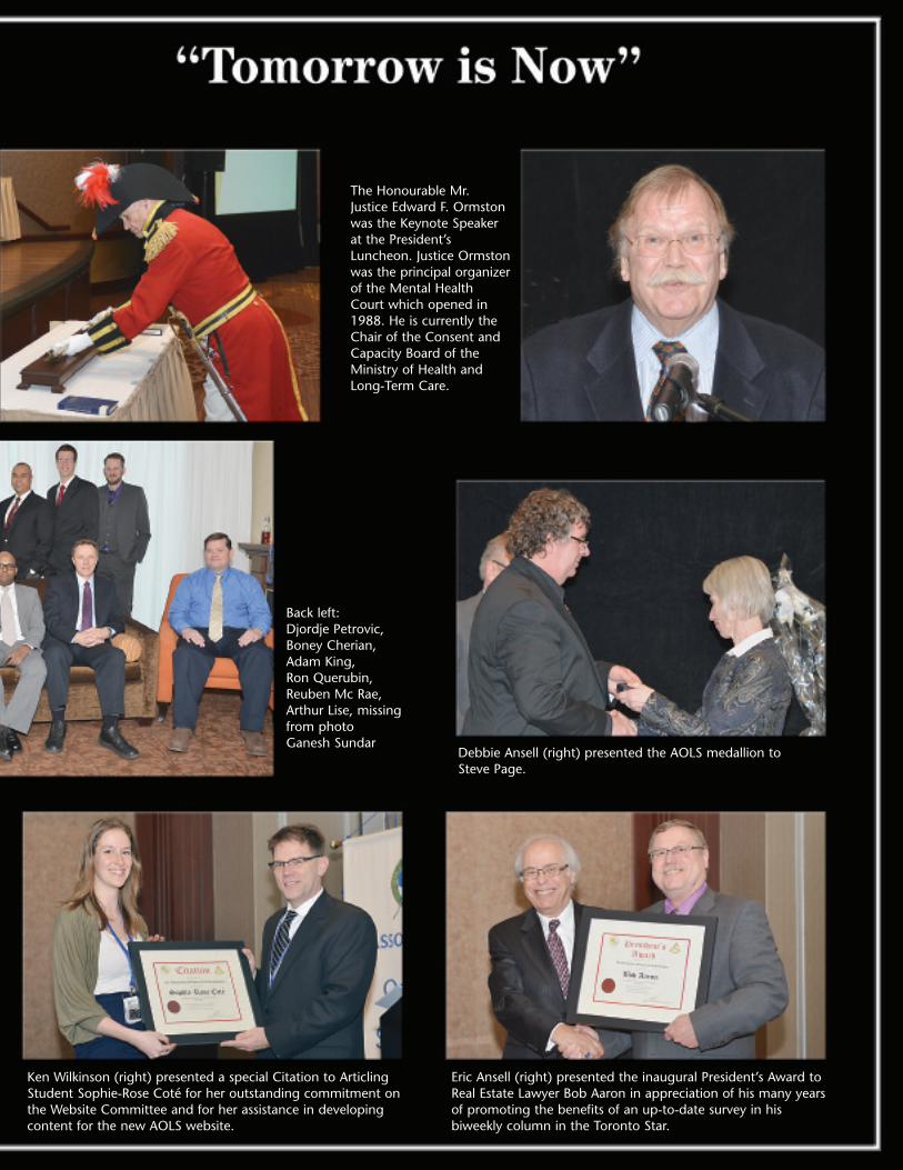
The Honourable Mr.Justice Edward F. Ormstonwas the Keynote Speakerat the President’sLuncheon. Justice Ormstonwas the principal organizerof the Mental HealthCourt which opened in1988. He is currently theChair of the Consent andCapacity Board of theMinistry of Health andLong-Term Care.
Debbie Ansell (right) presented the AOLS medallion to Steve Page.
Ken Wilkinson (right) presented a special Citation to ArticlingStudent Sophie-Rose Coté for her outstanding commitment onthe Website Committee and for her assistance in developingcontent for the new AOLS website.
Eric Ansell (right) presented the inaugural President’s Award toReal Estate Lawyer Bob Aaron in appreciation of his many yearsof promoting the benefits of an up-to-date survey in hisbiweekly column in the Toronto Star.
Back left: Djordje Petrovic,Boney Cherian,Adam King, Ron Querubin, Reuben Mc Rae,Arthur Lise, missingfrom photo Ganesh Sundar

Platinum Sponsors
Cansel
The Connectors Insurance GroupLtd. represented by Bob Morrow
and his wife Leslie
The CG&B Group and NovexInsurance Company represented by
Mark Sampson
Krcmar Surveyors Ltd. representedby Tom, Maya and Sasa Krcmar
Sani International TechnologyAdvisors Inc. represented by Tony Sani
GeoShack Canada
Sokkia Corporation Canada Tulloch Mapping SolutionsLeica Geosystems Ltd.
Mel Truchon (left) and Master ofCeremonies David Raithby at theWelcoming Party.
Mel Truchon (left) and the Scavenger Huntwinners (left to right): Philip Robbins, Alec Mantha and Duy Tran.
Event Sponsor
Thanks to all who laced ‘em up inthis year’s hockey game and a specialthanks to Harry Kalantzakos forpulling double duty, alternating asgoalie for both teams! Thanks also toPat Hills from Cansel for organizingthe game again this year. It hasbecome a real tradition at the AGM.See you all next year in Huntsville!
Hockey at the AGM!
Thanks also to
Land Survey Records Inc.
and
Teranet
˘

Front left: Ron Dore, Rob Stirling, Bob Clipsham, Rodney ReynoldsBack left: Gary Phillips, Kerry Hillis, Daniel Kreze, Duncan Ashworth
Front left: Rick Miller, Gary Auer, Maureen Mountjoy, Marvin McNabbBack left: Dave Urso, Doug Culham, Eric Ansell, Blain Martin
Front left: Ron Stewart, Adam Kasprzak,Dave Dorland, Ed GrenkieBack left: Bill Buck, Alex Wilson, Kim Hustead, Bob Hawkins
Front left: Tim Hartley, Ron Jason, Wally Kowalenko, Dave HorwoodBack left: Bruce McMurchy, Don Roberts,Russ Jones, Ralph Benedict
Front left: Brent England, Ivan Wallace, Tom Bunker, Tom GlassfordBack left: John Gutri, John Kennedy, Rob Harris, Scott McKay
Front left: Paul Church, Talson Rody, Al Worobec, John VinklersBack left: Dave Searles, Paul Torrance, Doug Hunt, Peter Moreton
Front left: Ed Herweyer, Lorraine Petzold,Andrea Tieman, Anne ColeBack left: Dan Dolliver, Paul Forth, Paul Riddell, Brian Maloney
Front left: Colin Bogue, Brent Collett, Bill Bennett, Al RoccaforteBack left: Geoff Aldworth, Steve Balaban,Ernie Gacser, Rod Finnie
Front left: Jack Monteith, Jack Young, Norm Sutherland, Drew AnnableBack left: Ross Clarke, Dan Vollebekk
Veterans’Dinner
Front left: Des Rasch, Gord Good, ArdonBlackburn, Doug Culbert · Back left: Murray LeGris, Paul Wyman, Tony Roberts,Jim Hill
AGM Parliamentarian Jack Young was theMaster of Ceremonies at the Veterans’Dinner

IntroductionGeographic information systems technology has generally
been ignored or misunderstood by the cadastral surveyor.There has been significant growth in this sector in the pastdecades. In most cases this growth has significantlyoutpaced the growth of the cadastral surveying sector.
The following is a brief description of some of thechanges in the GIS sector that are converging to create GISrelated growth opportunities that surveyors could consider.
Open Government/Open DataThere is an almost universal drive by governments in
Canada to be more open and transparent. It is hoped thatopen government will stimulate job creation and economicgrowth. The government hopes to engage its citizens in 3key areas:
• open data• open dialogue (citizen engagement)• open information (processes, policies, services, etc.)
The Ontario government has almost completed a projectto catalogue and inventory its data holdings. The govern-ment is also determining what data will be readily availableand how to provide access to it. The emerging policy posi-tion is that all data should be open. Data custodians willhave to provide a business case to justify restricting datafrom being made available. The key criteria for restrictingdata from the open category are that the data has personaland sensitive information in it.
The Ontario government terms1 of use are very liberal.Essentially, it grants users the right to use the data in anyway, subject to the following:
• the use must be lawful• there must be an acknowledgement of the source of
the data• the user must not imply any official status or that the
government endorses your use of the data• the user assumes all risk in its use of the data (as is)
The municipal and federal open data usage terms andconditions are similar in intent. Note that, in some cases,there may be additional restrictions/terms on data where thedata is encumbered by sharing agreements with other parties.
There is already signif icant spatial data available.The Ontario government open data website(https://www.ontario.ca/government/government-ontario-open-data) lists the available data. This data includes thetraditional topographic and related data such as thefollowing from MNR:
• Cosine• Ontario Road Network (ORN)
• Ontario Parcel (has 3rd party IP conditions)• Orthophotography and Imagery• Basemap (OBM) and Related Data
In addition to the above, there are data from otherministries that may be used by cadastral surveyors to expandtheir services to their clients. Below are just a few examplesof provincial data:
• water well database locations (Ministry ofEnvironment)
• meat plants and farmers markets (Ministry ofAgriculture)
• construction projects, traffic cameras (Ministry ofTransportation)
Similar data inventory directories are available atthe municipal level. For instance the following linklists the City of Hamilton open datahttp://www.hamilton.ca/ProjectsInitiatives/OpenData/.A simple search of other municipal web sites should revealthe data that is currently available and what the conditionsof use are.
Data StandardsThere is a significant change underway in all areas of
information technology. GIS technology is no exception.There are several data standards initiatives under way inCanada/Ontario that surveyors should be aware of. A few ofthese are briefly listed below:
• Geofoundation Exchange (GFX)° topographic basemap data assembled from the
authoritative source (e.g.: municipality) thenautomatically rolled up to other levels of govern-ment (scales)
° technology independent data exchange workflow° expandable to other data themes (e.g. parcel)° sponsored by NRCan
• Canadian Municipal Data Model (promoted by EsriCanada)
° harmonized information model of GIS data setscommon to local municipalities
° common workflow (requirements, inputs, func-tions and outputs)
° systems/applications built using the model° includes parcel information° parcel maintenance workflow in place
• Community Maps (Esri Canada initiative)° Esri program to publish authoritative (municipal)
large scale source data in a graphic basemap forpublic use
° IP for the data remains with the source agency
DATA and GISBy Barry Costello, O.L.S., O.L.I.P.
cont’d on page 261 the official text of the Ontario data license is found at: https://www.ontario.ca/government/open-government-licence-ontario
24 Ontario Professional Surveyor, Spring 2014

° agreed to update/maintenance cycle° frees the municipality from distributing data and
ensures all parties are working on a common base° relies on the Canadian Municipal Data Model
The initiatives above are making data easier to use. Also,the data conversion time has been significantly reduced.This makes adding and using a variety of data less costly forthe surveyor and his/her clients. More services can beoffered at attractive prices.
TechnologyThe biggest obvious impact on GIS has been apps and
GIS type applications on the smartphone and tablet. Anexample is Esri’s ArcGIS Online Collector application. WithCollector, field data collection forms can be very easilydesigned built and deployed on phones and tablets. Thistechnology can significantly reduce the cost of one offinspection type field data collection projects.
Hosted services are a new trend. A simple explanation ofhosted services is the 3rd party operation of an organiza-tion’s GIS servers and data management activities. Hostedservices have also expanded to include specialized appli-cations. Hosted services are becoming an attractivealternative for organizations wishing to free themselves ofthe activities associated with infrastructure, software anddata management.
An example of hosted services as an application is theirAutomatic Vehicle Location (AVL) system Esri operates formunicipalities in southeastern Ontario. The only technologythe municipality has is sensors in the vehicles. The vehicletracking, usage reporting, data management software andthe data itself is housed on Esri’s infrastructure. The clienthas a simple web interface to view and query the data.
Cloud computing takes hosted services to a higher level ofsophistication. In a cloud computing environment the tech-nology (hardware and software) is distributed on aubiquitous network of computers. The same is true for thedata. With cloud computing, economies of scale reduce thecost of technology and data significantly. Google Maps andEsri’s ArcGIS Online are examples of GIS cloud computing.Private cloud is a variant of the above where the network ofserver farms are limited to specific regions and/or tospecific clients.
Bundle Data and TechnologySoftware suppliers are bundling spatial and other data
with their technologies. This activity comes from the tradi-tional geomatics community as well as newcomers to thesector. What is interesting is the rapid rise in the consumer-ization of spatial data.
We now assume to have maps and applications on oursmartphones and tablets. Geofencing is one GIS technologythat we can expect to see having a significant presence.Geofencing monitors a smartphone or tablet location thentransmits a custom message to that phone when it crosses ageo-fence. Building and managing geo-fences may be anemerging line of business for GIS data consulting firms.
We will see many new developments in the smartphone andtablet markets. Firms like Geoloki, Geofeedia, Hotstop(recently bought by Apple), etc. are new entrants into theconsumer spatial technology industry. There is room for thesurveyor to develop similar applications for his/her traditionalcustomer base.
Google, Microsoft and Apple all provide mapping and loca-tion based maps and services on their technology platforms.Esri has gone a step further and bundled socio-economic,business, demographic and lifestyle information into itsArcGIS Online product. This data used to be somewhat diffi-cult for small firms to acquire and use. Now it is there as partof your subscription. This data is simply there, on-line, andavailable to use by just turning on the layer.
So now for a small cost, a surveyor can perform locationanalytic queries such as “find me the count of male/females,in 10-year gradients, within a 5 minute drive time of aspecific location (point, line or polygon)”. Furthermore, theuser interfaces have improved to the point that this type ofquery can be taught in about 15 minutes.
Opportunities for SurveyorsThe following factors are converging and creating a
period of disruption:• open data/government• data and technology standards• social media and the consumerization of mapping• cloud technology and hosted services are reducing
spatial data management costs• fiscal constraint
Through this change, new opportunities for the profes-sional surveyor are emerging.
For a variety of reasons, the cadastral surveying professionis focused on asserting its copyright on the plans and otherdocuments produced by a survey. As a GIS professional, Ithink there are at least 3 other or additional areas that thesurveyor should also examine. These are access provision,custodianship and spatial data expertise. These three areasoffer opportunities for significant business growth.
Access providers are those who make data readily avail-able. The business models for access are subscriptions orusage charges. Data is stored in a secure server environmentwith secure access (portal) controls. Instead of sending datato a client/customer, an access key is provided along withbasic query functionality. Providing an access portal can bepositioned as a value-added service while at the same timecreating a non-labour revenue mechanism.
A spatial data custodian is the individual who managesdata for others. Organizations are embracing hosted andcloud technologies as cost saving alternatives to managingin-house systems. Examples of these technologies areGmail, blogs, Office 365, etc. We will likely see moredemand for 3rd party management of technology, applica-tions and spatial data.
The surveying community is well positioned to assumethe role of subject matter expert. In this opportunity area,
26 Ontario Professional Surveyor, Spring 2014
there is a role to play for establishing spatial data standards,ensuring quality for data that is collected from a variety ofsources and providing strategic advice to clients onspatial data management and use.
Barry Costello holds a C of R in Photogrammetry andGeographic Information Management. He is Manager, OntarioGovernment at Esri Canada. He can be reached by email [email protected] for further information.
Ontario Professional Surveyor, Spring 2014 27
NEWS FROM 1043
MEMBERS DECEASEDWilliam D. McConnell CR51 Jan. 7, 2014John “Jack” Gray 684 Jan. 30, 2014Roger Tomlinson Honorary Member Feb. 7, 2014Edward A. Graham 963 Mar. 24, 2014
RETIREMENTS/RESIGNATIONSDarko I. Poletto CR172 Dec. 26, 2013Malcolm R. Elms 1364 Dec. 27, 2013Robert Naraine CR71 Dec. 31, 2013R. John Halsall 1503 Dec. 31, 2013Michael T. Franey CR77 Dec. 31, 2013Anil Agnihotri 1772 Dec. 31, 2013B. Roger Pickard 1363 Dec. 31, 2013Andrew Lyszkiewicz CR56 Jan. 1, 2014James M. Secord 1418 Jan. 1, 2014Stivell Ramchuram CR10 Jan. 1, 2014
Walter Kowalenko 1488 Jan. 1, 2014Richard Larocque 1257 Jan. 1, 2014David N. Churchmuch 1265 Jan. 1, 2014Brian J. Maloney 1549 Jan. 1, 2014John A. Stanton 1143 Jan. 1, 2014Denis D. Blais 1594 Jan. 1, 2014R. Dean Dunlop 1726 Jan. 1, 2014Timothy Rowe 1362 Jan. 1, 2014Talson Rody 1096 Jan. 1, 2014Thomas H. Brooks 1268 Jan. 1, 2014David B. Searles 1225 Jan. 1, 2014Paul F. Mrstik CR45 Jan. 1, 2014Robert J. C. Gaspirc 1545 Jan. 1, 2014Sarah J. Cornett 1691 Jan. 1, 2014Margo L. McGeorge 1707 Jan. 1, 2014Bruce I. McMurchy 1109 Jan. 31, 2014Adam King 1972 Mar. 11, 2014
Changes to the Register
cont’d on page 34

Townships Named For Surveyors(Part 2)By Allan Day
HELP WANTED If I’m missing any townships I would appre-ciate an e-mail telling me about the township. Thank you.
Parke Township named for Thomas Parke. Parke was anarchitect, builder, journalist and political figure in UpperCanada. He worked with John Ewart as a master carpenter ona number of construction projects, including the new parlia-ment buildings at York. In 1834, he was elected to theLegislative Assembly of Upper Canada for Middlesex and hewas re-elected in 1836. In 1839 he was a co-founder of theCanada Inquirer, later the London Inquirer and a reform-oriented newspaper. He was appointed justice of the peace inthe London District in 1840. In 1841, he was appointed asSurveyor General serving until 1845 when the office was abol-ished and was later revived in 1845. (8 Victoria ch. 11, sec. 1)Peterson Township named for Peter Alexander Peterson.Peterson was articled to Thomas C Keefer, PLS and wasappointed as a Land Surveyor on July 10, 1863. His profes-sional activities were not directed to surveying but alongwaterworks railway engineering lines. Between 1863 and1865 he was working on various engineering jobs withThomas Keefer. In 1865 he went into private practice andbetween 1885 and 1886 was in charge of large re-construc-tions of dams on the Grand River46. In 1867 he made surveys,plans and estimates for the Petrolia branch of the GreatWestern Railway. In the autumn of the same year he wasappointed as Resident Engineer of the Northern Division ofthe New York and Oswego Midland Railway. In March 1868he was appointed as Resident Engineer of the BathurstDivision of the Intercolonial Railway in New Brunswick andremained there until 1872 when he resigned and becameChief Engineer of the Toronto Water Works. By the end of1875 he left the Toronto Water Works after being appointedby the Quebec Government to be the Chief Engineer of theMontreal and Ottawa section of the Quebec, Montreal,Ottawa and Occidental Railway.Ridout Township was named in honour of Thomas Ridout.Ridout is a distinguished Toronto family name. Ridout startedwork in 1793 as clerk for the Surveyor General. In 1810, hewas appointed to the post of Surveyor General for UpperCanada. He had also been named Registrar for York Countyin 1796. He and William Chewett acted jointly as SurveyorsGeneral in 1799, 1802, and 1807. He became a justice of thepeace in the Home District in 1806 and Chairman of theHome District Council from 1811 to 1829. In 1812, he waselected to the Legislative Assembly of Upper Canada repre-senting East York and Simcoe. He served on the board set upto deal with claims for compensation for losses sustainedduring the War of 1812. In 1825 he was named to theLegislative Council. In 1827 he was appointed to the firstboard of King’s College.
Smith Township47 may have been named for Sir DavidWilliam Smith. He was a soldier and political figure inUpper Canada. He joined his father’s regiment, the 5thRegiment of Foot, as an Ensign in 1779 and became aCaptain in 1790. He served on the land board in the HesseDistrict48 in 1791 and 1792. Lieutenant Governor JohnGraves Simcoe made him Acting Deputy Surveyor Generalin 1792 and he was appointed Surveyor General of UpperCanada in 1798. In 1792, he was elected to the 1stParliament of Upper Canada representing Suffolk & Essex.In 1796 he was elected in the 3rd riding of Lincoln. Hebecame a member of the Executive Council of Upper Canadain 1796. In 1800, he was elected again to the LegislativeAssembly representing Norfolk, Oxford & Middlesex. Smithwas speaker for the Legislative Assembly from 1796 to 1801.In 1802 he returned to England and, in 1804 resigned fromhis appointments in Upper Canada. He began a secondcareer as property manager for the Duke of Northumberland.He was made a baronet on August 30, 1821. Smith received61 different appointments49 during his public career betweenSeptember 8, 1779 and November 1836.Smith Township47 is quite possibly named for TheHonourable Samuel Smith. He was a Loyalist British Armyofficer and politician. He was appointed to the ExecutiveCouncil of Upper Canada and appointed Administrator ofUpper Canada. In 1777, he joined the Queen’s Rangersduring the American Revolutionary War. He rose to the rankof Captain. He was promoted to the position of Lieutenant-Colonel of his regiment in 1801. Smith was appointedNovember 30, 1813 to the Executive Council of UpperCanada. In 1817 he was sworn in as Administrator of UpperCanada in the absence of Lieutenant Governor Francis Goreand served until 1818. He acted again as Administrator in theabsence of Lieutenant Governor Sir Peregrine Maitland forthree months in 1820. As Administrator, Smith was advisednot to grant land to American immigrants until they had takenthe oath of allegiance and resided in Upper Canada for sevenyears. He decided to follow the advice of his ExecutiveCouncil and not remove title to the land from those who didnot qualify. Smith retired from the Executive Council inOctober 1825.
Speight Township named for Thomas Bailey Speight. In1877 he secured a position with Silas James who was aDominion and Provincial Land Surveyor. Speight success-fully passed the necessary preliminary examinations and wasarticled to Silas James who was the Superintendent of Yorkroads. In 1881 he passed the examinations and became anOntario Land Surveyor and formed a partnership with James.The partnership lasted four years under the name of “James
cont’d on page 30
28 Ontario Professional Surveyor, Spring 2014

& Speight”. In November 1882 he successfully wrote hisexaminations to become a Dominion Land Surveyor. In 1885Speight and Colonel Arthur Jabel Van Nostrand entered intopartnership. The firm was very active in opening up lands inboth northern and southern Ontario. Over thirty TownshipBase Line and Meridian Surveys were performed by the firmby 1911. Some of the survey work that was performedincluded Township Outlines in 1897 and Base and MeridianLines in Algoma in 1897. Speight was in charge ofExploration Part #1 in 1900, Base and Meridian Lines in theDistricts of Algoma and Nipissing from 1903 – 1905 andBase and Meridian Lines in Algoma and Thunder BayDistricts. He was involved in the incorporation of theAssociation of Ontario Land Surveyors in 1892.Staunton Township named for Francis Hardwick Lynch-Staunton. He was offered a professorship in chemistry atTrinity College in Dublin, Ireland. For three years he workedon the Ordinance Survey of Ireland. He immigrated toCanada in 1854. He articled to John Lindsay and became aLand Surveyor on October 11, 1856. In 1860 he was aLieutenant-Colonel of the first Battalion of the Militia forBruce County. Lynch-Staunton practiced land surveying andcivil engineering for 10 years for the County of Bruce. Hewas also a Dominion Land Surveyor.Strange Township named for Henry Strange50 (General) OLS#1. Strange was born in Demerara51 in the West Indies. He andhis sister were sent to England to live with his grandmotherwhere he received his classical education. He understood sevenlanguages and was an excellent mathematician and musician.At the age of twenty he came to Canada and settled first inGuelph. For a short time he went to the United States and uponhis return he went to Rockwood52 and acquired about 1,200acres of land53. He studied surveying under Peter Carroll,Deputy Provincial Surveyor54 and qualified as a DeputyProvincial Surveyor on November 30, 1838. He worked onsurveys for the Grand Truck Railway between Toronto andSarnia, Great Western Railway from Niagara Falls to Windsorand the Guelph and Galt Railways. He also surveyed the Townof Rockwood and part of the City of Guelph. He served in theCanadian Forces and for Sir Allan Napier McNab55 in theRebellion of 1837 – 3856 and was taken prisoner at Detroit.Sutcliffe Township named for Homer Wilson Sutcliffe. Aftergraduating from high school he attended the University ofToronto obtaining his BASc57 in 1907. He then apprenticed to JH Smith of the firm of Sinclair & Smith of New Liskeard. Hewas granted his certificate as an Ontario Land Surveyor on May11, 1908. Later in 1908 he formed a partnership with ErnestWesley Neelands under the name of “Sutcliffe and Neelands”.The firm carried out extensive surveys in Northern Ontario. Tiernan Township58 named for Joseph Martin Tiernan. He wasarticled to Augustus MacDonell for three years. He wasappointed as a Land Surveyor on January 6, 1886. His surveywork as a Land Surveyor and Municipal Engineer was in theTilbury area. He also did work for the Ontario Government inNipissing, Algoma, Thunder Bay and Rainy River Districts.Tiernan surveyed the townships of Dack, Tolten, Porter, Hanmer,Archibald, Tupper, Aubrey, Southworth, Melgund and Mutrie.He was also in charge of Party #6 of the Exploration Survey in190059. Shortly after completing the exploration survey he passed
away of typhoid fever on December 15, 1900.van Nostrand Township named for Arthur Jabel vanNostrand. (Lieutenant-Colonel) He was educated in Publicand High School in Newmarket. In 1879 he passed his prelim-inary examination for land surveying and was articled forthree year’s to P S Gibson, PLS. In May 1881 he transferredhis articles to Major A C Webb acting as an assistant onDominion Land Surveys. Later in November 1881 he trans-ferred back to P S Gibson. In October 1882 he passed hisexamination to become an Ontario Land Surveyor and inNovember of the same year he became a Dominion LandSurveyor. In 1883 and 1884 he was engaged with Major A CWebb and Joseph Doupe on surveys for the Dominiongovernment. In 1885 Thomas Bailey Speight and he enteredinto partnership. The firm was very active in opening up landsin both northern and southern Ontario. Over thirty TownshipBase Line and Meridian Surveys were performed by the firmby 1911. Some of the survey work that was performedincluded Township Outlines in 1897, Base and MeridianLines in Algoma 1897, Base and Meridian Lines in theDistricts of Algoma and Nipissing from 1903 – 1905 andBase and Meridian Lines in Algoma and Thunder BayDistricts. In 1893 he entered the Corps of Guides as aLieutenant and was later promoted to the ranks of Captain,Major and Lieutenant-Colonel in 1911. He also acted as anIntelligence Officer from 1896 to 1911.Weaver Township named for William Frederick (Fred)Weaver. He and his family emigrated from England in 1908and settled in the Toronto beaches area. He attended Earl GreyPublic School and Riverdale Collegiate to Grade 10. Due tofamily finances he went to night school to finish his schoolingto Grade 12. He was engaged by the firm of Speight and vanNostrand in 1923. He qualified as an Ontario Land Surveyor onMay 22, 1926 under the direction of Ralph M Anderson, OLS.In 1930 he had the opportunity to join the Surveys Branch ofthe Department of Lands and Forests and became Surveyor andChief Draftsman working his way up to Chief Inspector ofSurveys and Assistant to the Surveyor General. During hisyears with the government he was responsible for the annul-ment of non-essential Crown Township subdivisions where theoriginal survey monuments and lines had become obliterated.He also prepared contracts for the restoration of original surveymonuments and original and retracement Crown surveys.Wiggins Township60 named for Thomas Henry Wiggins.Wiggins was a combination of surveyor/geologist. He becamean Ontario Land Surveyor on November 10, 1891 and studiedsurveying with Willis Chipman. He spent the first years of hiscareer in Ontario with an office in Cornwall. He spent twoyears in the Lake Superior and Rainy River area doing geolog-ical work and surveying mining claims. When he worked withWillis Chipman they did mainly municipal surveys61 anddrainage work. Between 1904 and 1920 he was in Saskatoon,Saskatchewan doing surveying and later worked most exten-sively in real estate. After 1920 he divided his time betweenSaskatoon and Napanee. He and Bryce Johnson Saundersformed a partnership in Brockville. Wilmot Township47 may have been named for Samuel StreetWilmot. He was born in New York State and was the son ofMajor Samuel Wilmot, who came to New Brunswick with his
30 Ontario Professional Surveyor, Spring 2014

family after the American Revolution. In 1796, Wilmot movedto Upper Canada and lived in Markham Township. His name ison the official list of Deputy Surveyors of Upper Canada in1811. He served as a major in the militia during the War of1812. Wilmot represented the Newcastle District in theProvincial Parliament. He was also selected by the Governmentto inspect and value the Crown and Clergy lands.Wilmot Township47 may have been named in honour of R JWilmot. Wilmot entered Parliament when the Secretary for theColonies introduced a bill into the Commons to carry out thesale of Clergy Reserve lands to the Canada Company. Hesucceeded Mr Goulbourn (unknown person) in office. He wasin office when this township was named in honour of theColonial Secretary instead of the surveyor.
Allan Day worked in the Office of the Surveyor General,Ministry of Natural Resources for 28 years as a Survey RecordsInformation Officer. He now owns a survey and research busi-ness in Peterborough. E-Mail [email protected]
46 Not known which Grand River.47 There appears to be a question on how Smith Township was named. According to Herbert F
Gardiner’s book “Nothing But Names” on page 183 it states “Smith Township may have beennamed for Sir David William Smith the Surveyor General”. On page 184 of the same bookit states “it is quite possible that the township was named for the Honourable Samuel Smith.The naming of Wilmot Township the same question comes up to the naming of the township.Gardiner’s book on page 258 states “may have been named for Major Samuel Street Wilmot,son of Captain Samuel Wilmot, a United Empire Loyalist who settled in New Brunswick”.On page 259 of Gardiner’s book he is suggesting that the township was named in honour ofR J Wilmot, Private Secretary to Lord Liverpool. I was unable to find out what the initialsstood for. I talked to Jeff Ball at the MNR, Geographic Names office and they have norecords that show who the townships were “officially” named after.
48 Western District was one of four districts of the Province of Quebec created in 1788 in thewestern reaches of the Montreal District and partitioned in 1791 to create the new colony ofUpper Canada. Known as Hesse District (from Hesse in Germany) until 1792, it was abol-ished in 1849. The district originally consisted of that part of Upper Canada west of a linerunning north from Long Point on Lake Erie.
49 See the 1894 Annual Report for the appointments.50 He was the first surveyor to be commissioned by the newly formed Association of Ontario
Land Surveyors in 1892.51 Demerara is a historical region in the Guianas on the north coast of South America which is
now part of the country of Guyana. It was a Dutch colony until 1815 and a county of BritishGuiana from 1838 to 1958. The name “Demerara” comes from a variant of the Arawak word“Immenary” or “Dumaruni” which means “river of the letter wood”.
52 Rockwood is the largest community within Eramosa Township on the banks of the SpeedRiver northeast of Guelph.
53 Henry Strange received the following property in Eramosa Township Lots 4 and 5,Concession 4 and Lots 4, 5 and 6 Concession 5.
54 Carroll studied under Mahlon Burwell and qualified as a DPS on October 14, 1828.55 Sir Allan Napier McNab, 1st Baronet was a Canadian political leader and Premier of the
Province of Canada before Canadian Confederation from 1854 to1856.56 The Rebellions of 1837-38 were two armed uprisings that took place in Lower and Upper
Canada in 1837 and 1838. Both rebellions were motivated by frustrations with politicalreform. A key shared goal was responsible government, which was eventually achieved inthe incidents’ aftermath. The rebellions led directly to Lord Durham’s Report on the Affairsof British North America and to The British North America Act, 1840 which partiallyreformed the British provinces into a unitary system.
57 The Bachelor of Applied Science is an undergraduate degree awarded for a course of studythat generally lasts three to four years in the United Kingdom and Australia, and four to sixyears in Canada, the Netherlands and the United States.
58 Formerly known as Township 30 Range 20.The name was changed in 1974.59 Party # 6 was to survey from Ombabika Bay at the north east of Lake Nepigon by Ombabika
River and canoe routes to Albany River and down the Albany River to the mouth ofKenogami. Ombabika River and canoe routes to be explored 20 miles on each side and theAlbany by streams flowing into it from the south.
60 Formerly known as Township 88.The name was changed in 1974.61 I found one municipal survey that was surveyed by Wiggins in the MNR Survey Records
office here in Peterborough. Cumberland Township #767 the Road Allowance betweenConcessions 10 and 11 across Lots 12 to 28.
Ontario Professional Surveyor, Spring 2014 31

32 Ontario Professional Surveyor, Spring 2014
Lifetime Members at March 31, 2014 (Individual)
EDUCATIONAL FOUNDATIONBOB MORROW (Honorary)
ANNA AKSANDONALD ANDERSON
DREW ANNABLEGEORGE D. ANNIS
DOUG ARONBRUCE BAKER
J.D. BARNESJOHN BARBER
GRANT BENNETTWILLIAM E. BENNETTGEORGE W. BRACKENWILLIAM A. BREWERHARRY BROUWERS
TOM BUNKERWILLIAM H. CARD
J.B. CHAMBERSPAUL CHURCH
DAVID CHURCHMUCHA.J. CLARKE
W. BRENT COLLETTRICHARD H. CREWE
ERIC CRONIER
DANIEL A. CYBULSKITOM CZERWINSKI
JAMES D. DEARDENARTHUR DEATH
RON DENISTERRY DIETZ
DAN DOLLIVERDON ENDLEMAN
WILLIAM M. FENTONCARL F. FLEISCHMANN
ERNEST GACSERDONALD H. GALBRAITH
BOB GARDENJAIME GELBLOOM
CHARLES W. GIBSONGORDON GRACIE
HOWARD M. GRAHAMJOHN GRAY
ROBERT C. GUNNROBERT HARRIS
JOHN M. HARVEYGORDON W. HARWOOD
ED HERWEYER
JAMES HILLHAROLD S. HOWDENROY C. KIRKPATRICK
CINDY KLIAMANANNE MARIE KLINKENBERG
WALLY KOWALENKOLENNOX T. LANE
RAYMOND T. LANEANITA LEMMETTY
OSCAR J. MARSHALLBLAIN MARTIN
RAYMOND J. MATTHEWSLARRY MAUGHANMIKE MAUGHAN
KENNETH H. MCCONNELLJAMES A. MCCULLOCH
SCOTT MCKAYRONALD G. MCKIBBONLAWRENCE A. MILLER
PAUL A. MILLERMANOUCHEHR MIRZAKHANLOU
W. HARLAND MOFFATTJ.W.L. MONAGHAN
PATRICK A. MONAGHANJOHN D. MONTEITH
PETER MORETONJIM NICHOLSON
DONALD W. OGILVIEFREDERICK J.S. PEARCE
E.W. (RED) PETZOLDN. LORRAINE PETZOLD
JOHN G. PIERCEHELMUT PILLER
ROBERT POMEROYYIP K. PUN
VALDEK RAIENDPAUL A. RIDDELL
RONALD W. ROBERTSONTALSON E. RODYHENRY ROESER
GRENVILLE T. ROGERSCARL J. ROOTH
ERICH RUEBFRED SCHAEFFER
ANDY SHELPH.A. KENDALL SHIPMAN
DOUG SIMMONDS
JOHN SMEETON
EDWIN S. (TED) SMITH
RALPH A. SMITH
TAD STASZAK
JAMES STATHAM
RON STEWART
NORM SUTHERLAND
MARK TULLOCH
MIKE TULLOCH
E. HENRY UDERSTADT
DAN R. VOLLEBEKK
BRIAN WEBSTER
GORDON WOOD
AL WOROBEC
ROBERT H. WRIGHT
GEORGE T. YATES
JACK YOUNG
GEORGE J. ZUBEK
Individual Sponsoring MembersANDRÉ BARRETTE ANDREW BOUNSALL
ANDREW CAMERON DOUG CULHAMRON EMO PAUL FRANCIS
NANCY GROZELLE BILL HARPERTRAVIS HARTWICK BOB MOUNTJOY
DAVID RAITHBY DAVID WOODLANDGEORGE WORTMAN DAVID WYLIE
Corporate Sponsoring MembersD. CULBERT LTD.
ADAM KASPRZAK SURVEYING LIMITEDKAWARTHA-HALIBURTON REGIONAL GROUP
KRCMAR SURVEYORS LTD.NORTH WESTERN REGIONAL GROUP
TARASICK McMILLAN KUBICKI LIMITEDI.M. PASTUSHAK LIMITEDTHAM SURVEYING LTD.
TRIMBLE CANADATULLOCH GEOMATICS INC.
Sustaining Corporate MembersA.J. CLARKE & ASSOCIATES LTD.
ANNIS O’SULLIVAN VOLLEBEKK LTD.ARCHIBALD, GRAY & MACKAY LTD.
CALLON DIETZ INCORPORATEDGEORGIAN BAY REGIONAL GROUP
R. AVIS SURVEYING INC.THE CG & B GROUP
EASTERN REGIONAL GROUPGALBRAITH, EPLETT, WOROBEC SURVEYORS
HAMILTON & DISTRICT REGIONAL GROUPJ.D. BARNES LIMITED
LEICA GEOSYSTEMS LTD.LLOYD & PURCELL LTD.
STEWART McKECHNIE SURVEYING LTD.MMM GEOMATICS ONTARIO LIMITED
MONTEITH & SUTHERLAND LTD.NORTH EASTERN REGIONAL GROUP
SOKKIA CORPORATION
SOUTH CENTRAL REGIONAL GROUPSOUTH WESTERN REGIONAL GROUP
STANTEC GEOMATICSTERANET INC.
Members as of March 31, 2014(Individual and Corporate)
BRUCE BROUWERS BILL BUCKJEFF BUISMAN KENT CAMPBELL
BRENT ENGLAND MICHAEL GRIFFITHSBOB HALLIDAY JACK KEATKEVIN KUJALA DAVID LAMONT
MURRAY LEGRIS BRIAN MALONEYROBERT MCCONNELL DAVID SEARLES
COOTE, HILEY, JEMMETT LIMITEDRON M. JASON SURVEYING LTD.KIRKUP & URE SURVEYING LTD.
DAVID B. SEARLES SURVEYING LTD.ALEX WILSON SURVEYING INC.
The Educational Foundation would like to recognize with thanks donations made in the memory of Ken Matthews,Harold Macklin, William McConnell, Jack Gray and Roger Tomlinson.
Report from the Annual General MeetingThe Board of Directors of the Educational Foundationdecided this year not to hold the auction of the Charles PotterCircumferentor during the Open Forum because of waninginterest and perceived discomfort from the members.However in the past few years, the auction was a catalyst formany of the members to step forward and pledge their dona-tions. Last year $8,875 was collected through pledges; thisyear we received $1,050. We are hoping that more memberswill send in their donations. Our goal is to raise $35,000 thisyear and with your support we can make this happen.
The Board of Directors would like to thank all of theExhibitors who provided a prize for the Welcoming PartyExhibitor Draw. Thanks to our ticket sellers, Lena Kassabian,Penny Castillo, Julia Savitch, Shawn Hodgson, and the Masterof Ceremonies David Raithby, the Foundation raised $2,285.
The 8th Annual Graduate Student Geomatics Poster Sessionattracted 11 entries from Ryerson University and YorkUniversity. The poster competition gives the surveying commu-nity an opportunity to see what type of research the graduatestudents are working on and reward them for their hard work.The Foundation sponsored $1500 for 1st place, $1,000 for 2nd
place, $750 for 3rd
place, $500 for 4th
place and $350 for 5th
place. The winningposters can be foundon page 14. Thanks toour judges, BoneyCherian, Reuben Mc Rae and WallyKowalenko.
EDUCATIONAL FOUNDATION NEWS
First place Geomatics Poster Session winner Akram Afifi, PhD Candidate from Ryerson University
with Executive Director Blain Martin (right).
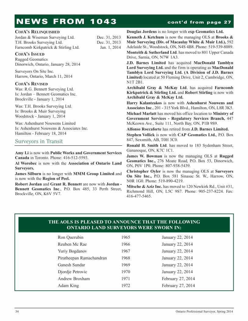
34 Ontario Professional Surveyor, Spring 2014
NEWS FROM 1043 cont’d from page 27
COFA’S RELINQUISHED
Jordan & Wiseman Surveying Ltd. Dec. 31, 2013T.H. Brooks Surveying Ltd. Dec. 31, 2013Farncomb Kirkpatrick & Stirling Ltd. Jan. 1, 2014
COFA’S ISSUED
Rugged Geomatics Dinorwich, Ontario, January 28, 2014
Surveyors On Site Inc.Harrow, Ontario, March 11, 2014
COFA’S REVISED
Was: R.G. Bennett Surveying Ltd.Is: Jordan – Bennett Geomatics Inc.Brockville - January 1, 2014
Was: T.H. Brooks Surveying Ltd.Is: Brooks & Muir SurveyingWoodstock - January 1, 2014
Was: Ashenhurst Nouwens LimitedIs: Ashenhurst Nouwens & Associates Inc.Hamilton - February 18, 2014
Amy Li is now with Public Works and Government ServicesCanada in Toronto. Phone: 416-512-5593.Al Worobec is now with the Association of Ontario LandSurveyors.James Silburn is no longer with MMM Group Limited andis now with the Region of Peel.Robert Jordan and Grant R. Bennett are now with Jordan -Bennett Geomatics Inc., P.O. Box 485, 33 Perth Street,Brockville, ON, K6V 5V7.
Douglas Jordens is no longer with exp Geomatics Ltd.Kenneth J. Ketchum is now the managing OLS at Brooks &Muir Surveying (Div. of Macaulay White & Muir Ltd.), 592Adelaide St., Woodstock, ON, N4S 4B8. Phone: 519-539-8089.Monteith & Sutherland Ltd. has moved to 801 Upper CanadaDrive, Sarnia, ON, N7W 1A3.J.D. Barnes Limited has acquired MacDonald TamblynLord Surveying Ltd. and the firm is operating as MacDonaldTamblyn Lord Surveying Ltd. (A Division of J.D. BarnesLimited) located at 50 Fleming Drive, Unit 2, Cambridge, ON,N1T 2B1.Archibald Gray & McKay Ltd. has acquired FarncombKirkpatrick & Stirling Ltd. and Robert Stirling is now withArchibald Gray & McKay Ltd.Harry Kalantzakos is now with Ashenhurst Nouwens andAssociates Inc., 201 - 315 York Blvd., Hamilton, ON, L8R 3K5. Michael Marlatt has moved his office location to Ministry ofGovernment Services - Regulatory Services Branch, 447McKeown Ave., Suite 111, North Bay, ON, P1B 9S9. Alfonso Roccaforte has retired from J.D. Barnes Limited.Stephen Vollick is now with CAP Geomatics Ltd., P.O. Box847, Sexsmith, AB, T0H 3C0. Ronald H. Smith Ltd. has moved to 183 Sydenham Street,Gananoque, ON, K7C 1C1.James W. Bowman is now the managing OLS at RuggedGeomatics Inc., 276 Moate Road, P.O. Box 53, Dinorwich,ON, P0V 1P0. Phone: 807-938-5439.Christopher Oyler is now the managing OLS at SurveyorsOn Site Inc., P.O. Box 581 Sinasac St. W., Harrow, ON, N0R 1G0. Phone: 519-890-4219.Mitsche & Aziz Inc. has moved to 120 Newkirk Rd., Unit #31,Richmond Hill, ON, L5C 9S7. Phone: 905-237-8224. Fax:416-477-5465.
Surveyors in Transit
THE AOLS IS PLEASED TO ANNOUNCE THAT THE FOLLOWING ONTARIO LAND SURVEYORS WERE SWORN IN:
Ron Querubin 1965 January 22, 2014
Reuben Mc Rae 1966 January 22, 2014
Yuriy Bogdanov 1967 January 22, 2014
Piratheepan Ramachandran 1968 January 22, 2014
Ganesh Sundar 1969 January 22, 2014
Djordje Petrovic 1970 January 22, 2014
Andrew Broxham 1971 February 27, 2014
Adam King 1972 February 27, 2014

Ontario One Call: Workingto protect our under-ground infrastructureLand surveyors recognize better than most Canadians just
how critical underground infrastructure is to everyone’s dailylives. This complex, subterranean maze of lines, wires, pipesand cables provides everything from heat, water, power, onlinebanking, 911 services and Internet access to millions.
Each day across Canada, however, an average of 35 majorutility lines sustain damage due to digging-related incidents.That translates into nearly 13,000 incidents or ‘strikes’ peryear. The financial and societal impacts associated with theseincidents (e.g. disruption of essential services, environmentalcontamination, lawsuits, repairs, evacuations, injuries anddeaths) can be enormous.
By working in concert with Ontario One Call (ON1Call),however, organizations such as the Association of OntarioLand Surveyors are helping to make Ontario a safer provinceby getting locates prior to breaking ground and through safedigging practices. The objective, of course, is to preventcostly utility damage, frustrating service disruptions and eveninjury or death. ON1Call remains committed to working withour members and other stakeholders to continuously improveour effectiveness.
In the makingON1Call was created in 1996 by three founding members:
Bell Canada, Enbridge Gas and Union Gas. The idea was tocreate an efficient ‘One Call’ system that would help reducecosts and make it easier for companies to receive timely, accu-rate responses to their locate requests. In 2011, ON1Callbecame a not-for-profit organization with an open, transparentstructure that enables and encourages members to have a sayon the organization’s major policies. The organization is collec-tively owned by its members, in other words, the companiesand municipalities that own Ontario’s buried infrastructure.
The organization has a Board of Directors that consists ofmembers, as well as an Operations Committee which is respon-sible for making decisions on day-to-day activities, whileincoming locate requests are handled by the call centre.
How it worksON1Call is in the business of providing peace of mind, one
phone call (or online request) at a time. They are the peopleyou call before you dig. The organization provides a freeservice that connects homeowners, landscapers and profes-sional contractors with the critical information they needabout what’s beneath them before they break ground.ON1Call processes this information – quickly and with anincredible degree of precision – and provides it directly to thecompanies and utilities that own the pipes, cables and powerlines beneath the ground so that they may provide a locate.
Under new legislation, the Ontario UndergroundInfrastructure Notification System Act, 2012, contractors arerequired to request a locate from ON1Call and to provide anaccurate overview of the information involved in the request.
When a locate request comes in, ON1Call records thecontact information, the specifics of the location and otherimportant details, for instance, details regarding excavationspecifications and the scope of work that is to occur. Callersreceive a ticket with a reference number that can be used totrack progress. The standard response time for a locaterequest is five business days.
While some land surveyors will likely have had situationsin the past in which locates took longer than expected,ON1Call understands the frustration this can cause andcontinues to do everything in its power to expedite thecompletion of these requests. The industry is optimistic thatthe new regulatory changes will serve to further streamlinethe process and result in more predictable and reliablecompletion times going forward.
ON1Call also offers a series of ‘filters’ to help membersbetter manage incoming requests. For example, there can befilters related to geographic location, the type of propertyinvolved in the request, the type of activity being undertaken,the depth of excavation, class of excavator and more.
Members also have the option to take advantage of aservice known as secondary screening. This allows ON1Callto have a closer look at the underground infrastructure on aparticular property and provide an overview and potentialclearance for the locate in question. Secondary screeningrequests can help save time, compared with the alternative ofhaving to dispatch a locate truck to the scene.
How to get the most out of ON1CallOne of the best ways to ensure a smooth, efficient experi-
ence with ON1Call is to provide the most accurate, detailedinformation possible. The more information ON1Call hasabout a locate request, the more efficient the process and themore accurate the locate can be.
In order to simplify the process, when contacting ON1Call,land surveyors should ensure the request is referenced as a‘Design and Planning’ request if the ground is not beingbroken. Some ON1Call members will provide mappingand/or drawings so that a physical locate is only requiredwhen actual excavation is going to occur. This process isintended to help surveyors, contractors and all other excava-tors to effectively plan the location of an excavation while nothaving to wait for physical locates to be completed untildigging will commence.
cont’d on page 38
36 Ontario Professional Surveyor, Spring 2014

ON1Call also provides a long-term suspend function that canbe used for large projects expected to extend over a long periodof time. For instance, an entire year’s worth of locates can beentered at once if the work schedule is known in advance.
Legislative changesUnder the Ontario Underground Infrastructure Notification
System Act, 2012, several important changes are taking place,aimed at streamlining the request process for excavators toobtain the location of buried infrastructure from undergroundinfrastructure owners or operators. The new legislation meansthat all infrastructure owners or operators are members ofON1Call and are required to provide information about theirunderground infrastructure to our organization.
RegulationsOnce the terms and conditions are passed, ON1Call will
become more actively involved in its regulatory role. Theseterms and conditions will help clarify which situations consti-tute an emergency, a priority and a standard locate request. Theywill also provide greater detail about enforcement principlesand procedures and emphasize the importance of understandingand respecting the definition of a proper emergency request.
In the near future, users will have the ability to submit offi-cial complaints via the ON1Call website (www.on1call.com).All such complaints will be investigated and referred to theCompliance Committee, which will make decisions abouteducation, guidelines and potential penalties.
EnforcementON1Call is committed to delivering a risk-based, propor-
tionate response that’s tailored to each situation that arises.The organization continues to support the principles of trans-parency, professionalism and neutrality. ON1Call is alsofocused on delivering for its members and other stakeholdersand working to resolve problems and finding collaborativesolutions that work over the long term.
Looking aheadCalling ON1Call before you dig is the law. It also makes
good business sense. Anyone that is in violation of the lawcould stand to incur penalties and consequences by means ofbeing investigated by regulatory bodies.
ON1Call remains focused on providing Ontario’s landsurveyors with the timely, accurate responses they need toconduct business as effectively as possible. Many of thechanges that continue to unfold with respect to legislation andregulation will help to further streamline our working rela-tionship, protect the health and well-being ofexcavators and reduce the occurrence of damage tounderground utilities.
For any questions or for further information, contact ElenaPilavakis, Ontario One Call’s Marketing Officer, pictured in thetitle block on page 36, by email at [email protected]
38 Ontario Professional Surveyor, Spring 2014

BOOK REVIEWS
In On the Map Simon Garfield leads us on astimulating journey grounded in the idea that
maps hold a key to what makes us human – andtells our stories. Scientists have even argued thatmapping, more than the development oflanguage, is what boosted our prehistoric ances-tors over the critical threshold in evolution.Garfield weaves a rich narrative tapestry rangingfrom the quest to create the perfect globe to thechallenges of mapping Africa and Antarctica,from spellbinding treasure maps to the naming of
America, from the Ordnance Survey to themapping of Monopoly. With delightful digres-sions along the way, it is an exploration of theunique way that maps both relate and realign ourhistory from the early sketches of philosophersto Google Maps and beyond. On the Map is awitty and irrepressible examination of wherewe’ve been, how we got there, and where we’regoing.
Information taken from the back cover.
Published by Gotham Books,a member of Penguin Group
ISBN 978-1-592-40780-4
From Meteorite Impact to Constellation Citytells a story that began billions of years ago
and encompasses dramatic physical and humanevents. Among them are volcanic eruptions,two meteorite impacts, the ebb and flow ofcontinental glaciers, Aboriginal occupancy,exploration and mapping by Europeans,exploitation by fur traders and Canadianlumbermen and American entrepreneurs, therise of global mining giants, unionism, pollu-tion and re-greening, and the creation of aunique constellation city of 160,000.
The title posits the book’s two main themes,one physical in nature and the other human:the great meteorite impact of some 1.85 billionyears ago and the development of Sudburyfrom its inception in 1883. Unlike other largecentres in Canada that exhibit a metropolitanform of development with a core andsurrounding suburbs, Sudbury developed in apattern resembling a cluster of stars indiffering sizes.
Information taken from the back cover.
The urge to map, to consciously orientourselves within a larger context, is a basic
human instinct. The graphic representation ofland and space, whether it is etched into anancient clay tablet or illuminated on a computerscreen, says something very deep to us. In thismasterful study, historian and cartographyexpert Jerry Brotton argues that far from beingpurely objective documents maps are inevitablysubjective expressions of the people who createdthem, intimately tied to the views and agendasof particular times and places. In A History ofthe World in 12 Maps, he examines a dozenworld maps from around the globe and through
the centuries to trace the long road to our presentgeographical reality.
Today, technology and access to unprecedentedamounts of information are dramaticallychanging the way we map our surroundings. Yet,Brotton argues, contemporary maps are no moredefinitive or objective than those of the past andwill continue to reflect and influence our ownideas about the world we live in. Readers of AHistory of the World in 12 Maps will never lookat a map in quite the same way again.
Information taken from inside the front and backcovers.
From Meteorite Impact to Constellation CityA Historical Geography of Greater Sudbury
By Oiva W. Saarinen
On the Map By Simon Garfield
A History of the World in 12 Maps By Jerry Brotton
Published by the PenguinGroup
ISBN 978-0-670-02339-4
Published by Wilfred LaurierUniversity Press
ISBN 978-1-55458-837-4
Ontario Professional Surveyor, Spring 2014 39

Published by:The Association of Ontario Land Surveyors(Established 1892)1043 McNicoll AvenueToronto, Ontario, Canada M1W 3W6Phone:416-491-9020 FAX:[email protected] * www.aols.org
Editor & Publication Manager:Maureen Mountjoy, O.L.S., O.L.I.P.Production Manager:Lori VeljkovicAdvertising Manager:Maureen Mountjoy, O.L.S., O.L.I.P.
Unless otherwise stated, material which originatesfrom our membership may be re-printed withacknowledgment.
Printed by Colour Systems IncorporatedOriginal graphics design by Uniq Graphics andDesign, Toronto, OntarioComputer implementation by nu Vision Images Inc.,Toronto, Ontario
Advertising Rates:1 time 4 times
1st Cover Not Sold Not Sold2nd and 3rd Cover Not Sold $6504th Cover Not Sold $750Full page 4 Colour $640 $6001 page B&W $440 $4001/2 page B&W $255 $2251/4 page B&W $175 $150
Colour ads: Add $50 for each colour up to 4 colours Inserts (supplied): Page rate plus 25%.(overleaf blank): plus 50%
Mechanical Requirements:Printed OffsetTyped Page: 48 picas wide x 63 picas deepBleed Size: 8-3/4” wide x 11-1/4” deepD.P.S.: 17” wide x 11” deep with bleedD.P.S.: 16” wide x 10” deep without bleed
Material Requirements:Four colour: Colour separations supplied, typeassembly and progressive proofs with colour bars.Black, black and one or two colours: Either film orart supplied with layout and copy; or completeassembly.
The Ontario Professional Surveyor Magazine ispublished quarterly as a medium of communicationbetween the Association and its members. Readersare invited to comment and express their opinionson relevant subjects.
The Ontario Professional Surveyor Magazine isdistributed to all members of the Association.
Subscription Rates to others: $40.00 per year or$10.00 per copy. All rates to us - no provision forcommissions or discounts.
Canadian Publication Sales Agreement # 40064685Postage paid Mississauga / Gateway
ALL PRICES LISTED ARE SUBJECT TO13% H.S.T.
Circulation (This Printing)
Ont. Land Surveyors & Associates 973Other Professional Affiliations 317Advertisers 20
Published Quarterly:next publication deadline:
May 15, 2014
Views and opinions in editorials and articles are not official expressions of theAssociation’s policies unless so stated.
The Ontario Professional SurveyorMagazine and its publisher accept no
responsibility for these views and opinions.
“Isaac Brock was one of the people to whom it is given tochange the course of history. But for the presence in UpperCanada in the summer of 1812 of this able and magneticgeneral officer (and a single battalion of British regularinfantry) the province would certainly havefallen to the United States; whether or not itwas recovered would have depended on thedetermination of the British government.”1
“Brock was born on the British ChannelIsland of Guernsey, the eighth son of amiddle-class family. Despite his lack ofextensive formal education, Brock appreci-ated its importance. It’s said that as an adulthe often spent his leisure time sequesteredin his room, reading books to improve hiseducation. He read many works on militarytactics and science, but ancient history andother topics also interested him.
When he was 15, he followed three of hisolder brothers into service in the British
Army, and advanced in rank mainly by purchasing promo-tions. He served in a number of locations before settling inCanada in 1802. In 1811, Brock attained the rank of major-general and took command of all British forces in Upper
Canada. He became the administrator ofthe province the same year.
When the Americans invaded UpperCanada on July 12, 1812, Brock was ready.He’d already recruited a force of citizensand forged First Nations alliances. FortDetroit fell to the British army and Brockwas hailed as a hero. After Detroit, themain American threat existed in Niagara,and it was here that Brock would fight hisfinal battle. The British were victorious atQueenston Heights, but Brock lost his lifewhile leading his soldiers in a charge. Alimestone monument that contains theremains of Brock is located at QueenstonHeights Park in Niagara Falls.”2
Major-General Sir Isaac Brock – “The Hero of Upper Canada”
40 Ontario Professional Surveyor, Spring 2014
Sir Isaac Brock, 1769-1812Photo credit: Library and Archives Canada,
Acc. No. 1991-30-1, e010767950, e0107679511 http://www.biographi.ca/en/bio/brock_isaac_5E.html2 http://www.brocku.ca/about/sir-isaac-brock
