optimizingtransportdataoptimizing transport data ... · optimizingtransportdataoptimizing transport...
TRANSCRIPT

Optimizing Transport DataOptimizing Transport Data Integration andIntegration and Management
Zhengdong HUANGZhengdongHUANGWuhanUniversity
2012/2/9 1Transport Sector and NAMAs - Manila
(IGES / CAI-Asia)
ContentsContents
Datafortransportplanningandmanagementg
Whyintegrationandmanagement?I d Issuesintransportdataintegration Technicalaspectp Institutionalaspect
Action examples Actionexamples Conclusions
2012/2/9 2Transport Sector and NAMAs - Manila
(IGES / CAI-Asia)
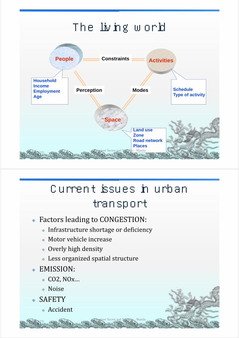
The living worldThe living world
People ActivitiesConstraints
HouseholdIIncomeEmploymentAge
ScheduleType of activity
Perception Modes
Spacep
Land useZoneRoad networkRoad networkPlaces
2012/2/9 3Transport Sector and NAMAs - Manila
(IGES / CAI-Asia)
Current issues in urban transport
FactorsleadingtoCONGESTION: Infrastructureshortageordeficiency Motorvehicleincrease Overlyhighdensity Lessorganizedspatialstructure
EMISSION: CO2,NOx… Noise Noise
SAFETY Accident Accident
2012/2/9Transport Sector and NAMAs - Manila
(IGES / CAI-Asia)4

Data in transport- categoriesData in transport categories
Socio‐economicdata(census,landuse…)
T t i f t t ( d f iliti ) Transportinfrastructure(roads,facilities...)
Transportservices(publictransit…)p (p )
Traveldemandandsystemuse(household,
activities,employment,freight…)
Transport impact (performance measure Transportimpact(performancemeasure,
environment…)
2012/2/9 5Transport Sector and NAMAs - Manila
(IGES / CAI-Asia)
Data needs - structureData needs structure
Demand attributes
Supply attributes
System data
Service data
Economic data
Demographic data
System performance
Facilities data
Condition data
Project data
data
Land use data
Travel dataProject data
Traveller behaviour data
Performance measures
Safety dataEmissions
System impactsimpacts
Air quality data Other Land use data Energy data EconomicAir quality data Other environment
data
Land use data Energy data Economic growth
2012/2/9 6Transport Sector and NAMAs - Manila
(IGES / CAI-Asia)
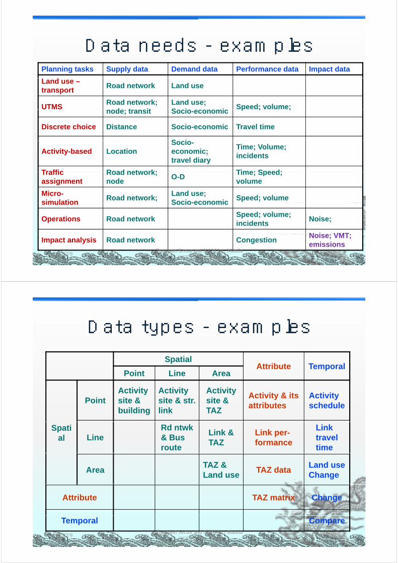
Data needs - examplesData needs examplesPlanning tasks Supply data Demand data Performance data Impact data
Land use –transport
Road network Land use
UTMSRoad network;
d t itLand use; S i i
Speed; volume;node; transit Socio-economic
p ; ;
Discrete choice Distance Socio-economic Travel time
S iActivity-based Location
Socio-economic; travel diary
Time; Volume; incidents
Traffic Road network; Time; Speed;Traffic assignment
Road network; node
O-DTime; Speed; volume
Micro-simulation
Road network;Land use; Socio-economic
Speed; volumesimulation Socio-economic
Operations Road networkSpeed; volume; incidents
Noise;
N i VMTImpact analysis Road network Congestion
Noise; VMT; emissions
2012/2/9 7Transport Sector and NAMAs - Manila
(IGES / CAI-Asia)
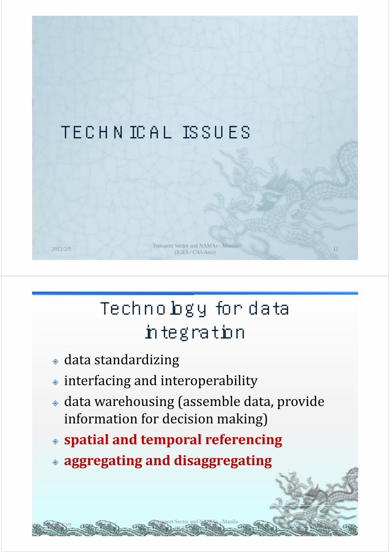
Data types - examplesData types examplesSpatialSpatial
Attribute Temporal Point Line Area
Activity Activity ActivityPoint
Activity site & building
Activity site & str. link
Activity site & TAZ
Activity & its attributes
Activity schedule
Spatial Line
Rd ntwk & Bus route
Link & TAZ
Link per-formance
Link travel time
AreaTAZ & Land use
TAZ data Land use Change
Attribute TAZ matrix Change
Temporal Compare
2012/2/9 8Transport Sector and NAMAs - Manila
(IGES / CAI-Asia)

ObservationsObservations
Dataisthekeyforplanningandcontrol Huge amount of transport data Hugeamountoftransportdata Spatialspan:region,city,district,site Temporalspan:year,month,day,hour Activity span: plan construction Activityspan:plan,construction,maintenance,monitor
Neededdatagobeyondthetransportsystemitselfy
2012/2/9Transport Sector and NAMAs - Manila
(IGES / CAI-Asia)9
Why transport data integration
Integration:tocoordinateorblenddistinctdataintoaunifiedwhole
Datasource Fromdifferentagenciesg Fromdifferentdatacollectiondevices Fromvolunteers
Datatype Spatial: areal linear point data Spatial:areal,linear,pointdata Temporal:hour,day,month,year Spatio‐temporal: both attributes Spatio‐temporal:bothattributes
2012/2/9Transport Sector and NAMAs - Manila
(IGES / CAI-Asia)10
TECHNICAL ISSUESTECHNICAL ISSUES
2012/2/9Transport Sector and NAMAs - Manila
(IGES / CAI-Asia)11
Technology for data integration
datastandardizing interfacing and interoperability interfacingandinteroperability datawarehousing(assembledata,provide
f f d k )informationfordecisionmaking) spatialandtemporalreferencing spat a a d te po a e e e c g aggregatinganddisaggregating
2012/2/9 12Transport Sector and NAMAs - Manila
(IGES / CAI-Asia)
Spatial and temporal referencing
Transportdataneedstobespatiallyandtemporallyanchoredp y
GISasadataintegratorS ti l ti l Spatialvsnon‐spatial
Points,lines,andpolygons Vectorsandimages Different layers Differentlayers Differentsources
2012/2/9Transport Sector and NAMAs - Manila
(IGES / CAI-Asia)13
2012/2/9Transport Sector and NAMAs - Manila
(IGES / CAI-Asia)14
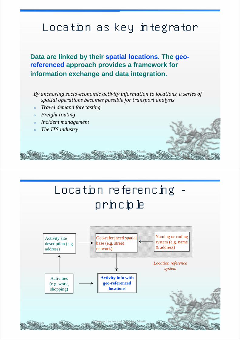
Location as key integratorLocation as key integrator
Data are linked by their spatial locations. The geo-referenced approach provides a framework forreferenced approach provides a framework for information exchange and data integration.
Byanchoringsocio‐economicactivityinformationtolocations,aseriesofspatialoperationsbecomespossiblefortransportanalysis
Travel demand forecasting Freight routing Incident management Incident management The ITS industry
2012/2/9 15Transport Sector and NAMAs - Manila
(IGES / CAI-Asia)
Location referencing -principle
Naming or codingActivity site description (e.g. address)
Geo-referenced spatial base (e.g. street network)
Naming or coding system (e.g. name & address)
Location reference system
Activity info with geo-referenced
locations
Activities(e.g. work, shopping)
2012/2/9 16Transport Sector and NAMAs - Manila
(IGES / CAI-Asia)
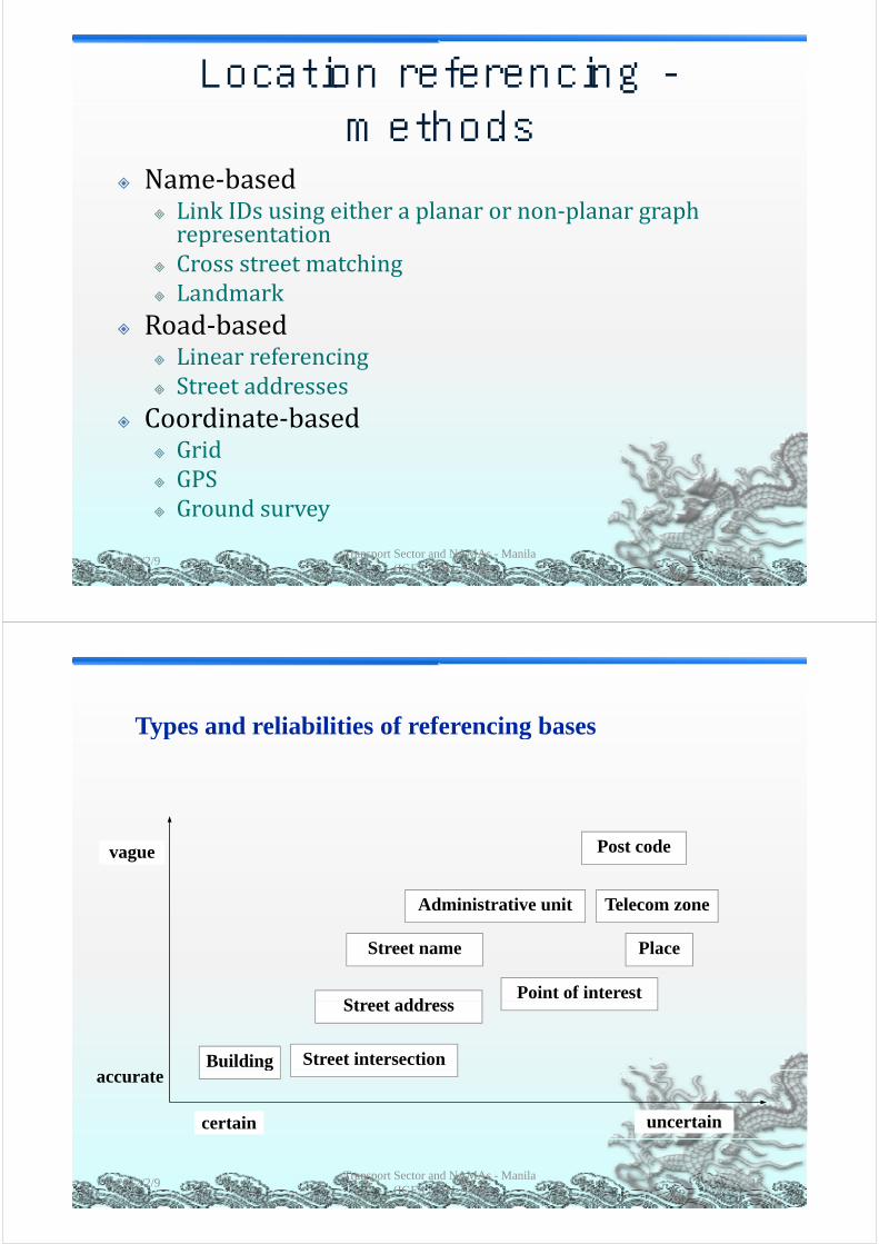
Location referencing -methods
N b d Name‐based LinkIDsusingeitheraplanarornon‐planargraphrepresentationrepresentation
Crossstreetmatching Landmark
Road‐based LinearreferencingS dd Streetaddresses
Coordinate‐based Grid Grid GPS Groundsurveyy
2012/2/9 17Transport Sector and NAMAs - Manila
(IGES / CAI-Asia)
Types and reliabilities of referencing basesTypes and reliabilities of referencing bases
Post codevague
Administrative unit Telecom zone
St t ddPoint of interest
Street name Place
Street intersectionBuilding
Street address
gaccurate
certain uncertain
2012/2/9 18Transport Sector and NAMAs - Manila
(IGES / CAI-Asia)
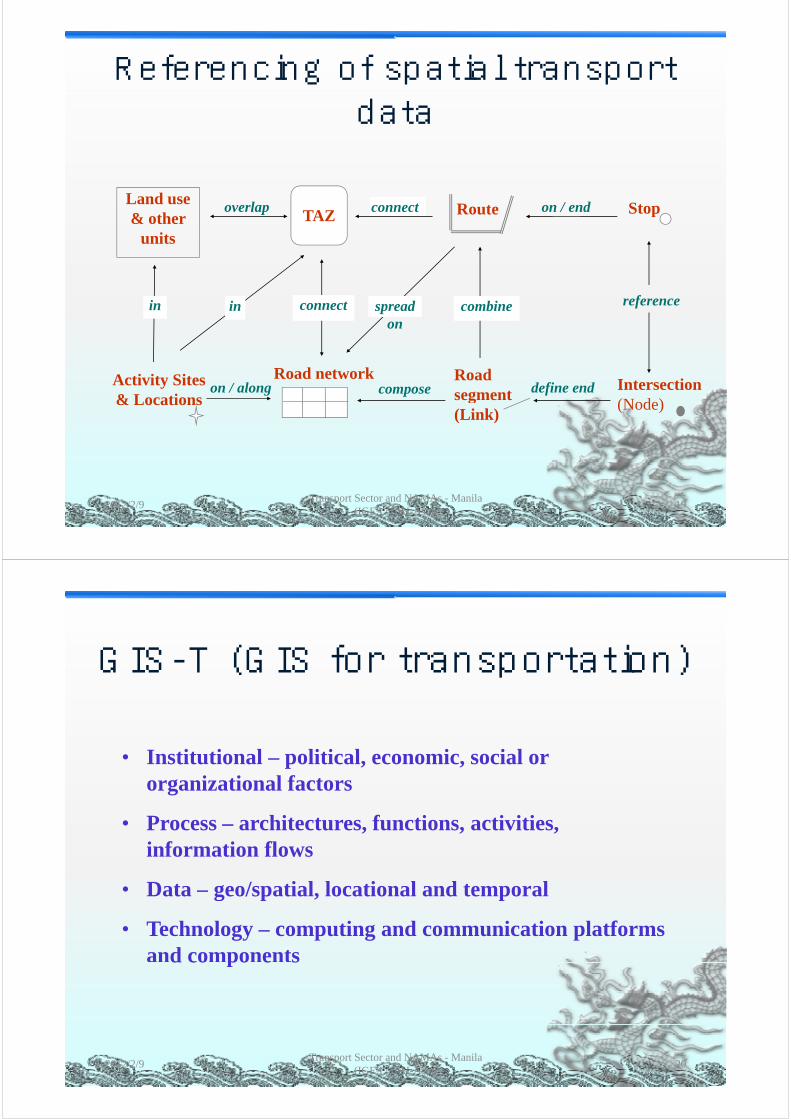
Referencing of spatial transport data
TAZ StopLand use & other
Routeoverlap connect on / endTAZ& other
units
referenceconnect spread on
combineinin
Road networkActivity Sites & Locations
Intersection(Node)
Road segment define endon / along compose
& Locations (Node)g
(Link)
2012/2/9 19Transport Sector and NAMAs - Manila
(IGES / CAI-Asia)
GIS T (GIS for transportation)GIS-T (GIS for transportation)
• Institutional – political, economic, social or i i l forganizational factors
• Process – architectures, functions, activities, information flows
• Data – geo/spatial, locational and temporal g p p
• Technology – computing and communication platforms and componentsd co po e s
2012/2/9 20Transport Sector and NAMAs - Manila
(IGES / CAI-Asia)

Transport Data Representation in GISTransport Data Representation in GISPl t k Li k d• Planarnetworks Link‐node
• Non‐planarnetworks Network+attributeM lti di i l 3 D / 4 D• Multi‐dimensional 3‐D/4‐D
• Nodeimpedance NodeattributeT l ( ) D i i• Traversals(routes) Dynamicsegmentation
• O‐Dpairs Table• Lanes Links+attribute• Visualisation Graphicalpresent• Temporalchanges Attributes+?
2012/2/9 21Transport Sector and NAMAs - Manila
(IGES / CAI-Asia)
Transport data model: UML conceptual view of spatio-temporal transportation object representation (Chen et al 2009)
2012/2/9Transport Sector and NAMAs - Manila
(IGES / CAI-Asia)22
temporal transportation object representation (Chen et al, 2009)

GIS and Transport modelsGIS and Transport modelsGIS Transport Model
• Multi-purpose Single purpose
p
• Data-driven Model-driven
G hi t t Ab t t t t• Geographic context Abstract context
• Many topologies Single topo (link-node)y p g g p
• Chain structures link-node structure
• Spatially-indexed Sort-indexed
• Many fields Few fields• Many fields Few fields
2012/2/9 23Transport Sector and NAMAs - Manila
(IGES / CAI-Asia)
GIS and transport modelsGIS and transport models
Dueker & Butler, 20002012/2/9 24Transport Sector and NAMAs - Manila
(IGES / CAI-Asia)
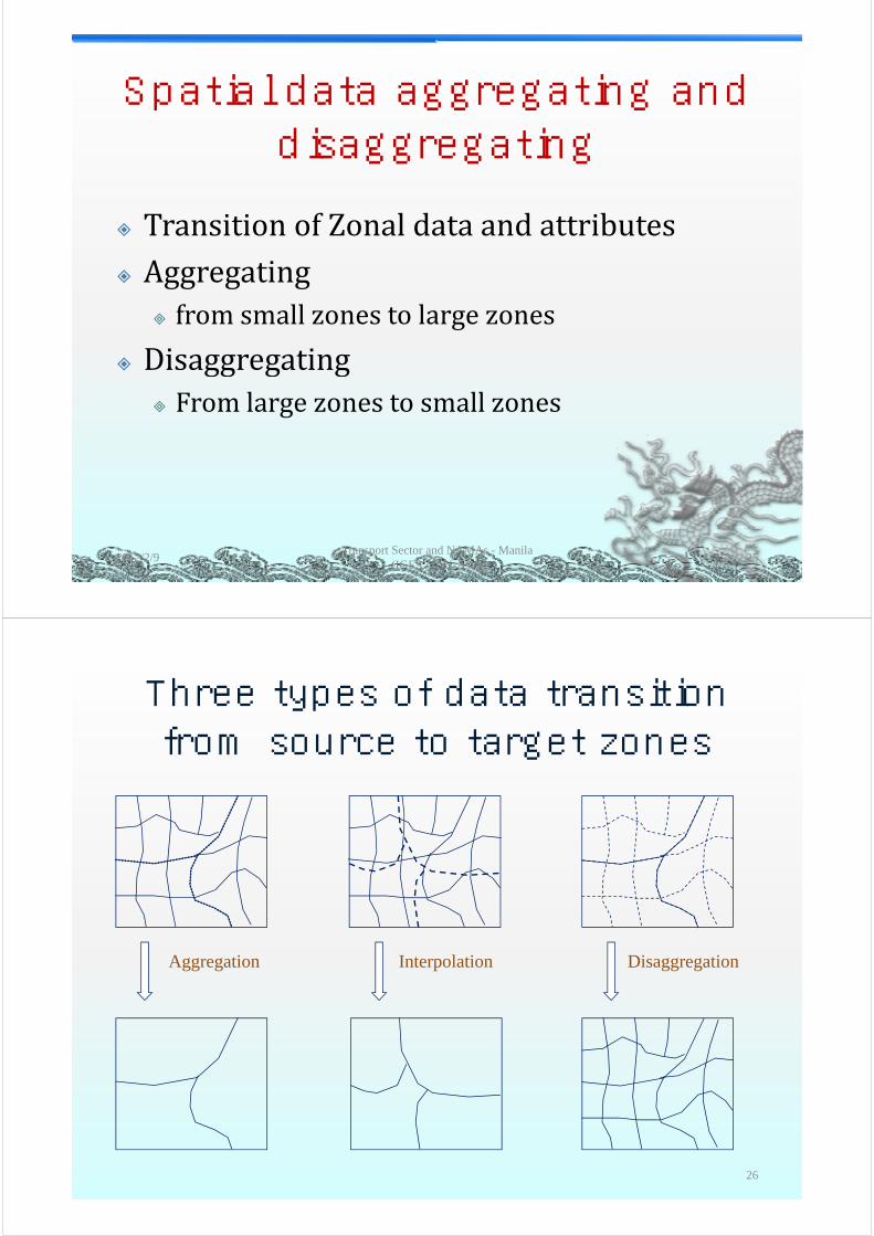
Spatial data aggregating andSpatial data aggregating and disaggregating
TransitionofZonaldataandattributes Aggregating
f ll t l fromsmallzonestolargezones
Disaggregating Fromlargezonestosmallzones
2012/2/9Transport Sector and NAMAs - Manila
(IGES / CAI-Asia)25
Three types of data transition from source to target zones
Aggregation Interpolation Disaggregation
26

Two approaches to zonal data transition
Adm. UnitsSource zonesAdm Units
Land use BuildingSource zones
Land
Disaggregation
Interpolationuse
BuildingGrid cellLand use BuildingInterm. zones
TAZ Oth TAZ Oth
Aggregation
TAZ; Other zonesTarget zones
TAZ; Other zonesTarget zones
(a) Interpolation (b) Disaggregation-aggregation
2012/2/9 27Transport Sector and NAMAs - Manila
(IGES / CAI-Asia)
Monte Carlo simulation (Spiekermann & W 2000)Wegener, 2000)
Doubly constraintDoubly constraint method(huang et al,2007), )
Implementation in ArcGIS
2012/2/9Transport Sector and NAMAs - Manila
(IGES / CAI-Asia)28

Homogeneous zones
Land use
2012/2/9Transport Sector and NAMAs - Manila
(IGES / CAI-Asia)29
Population disaggregated to raster cells
2012/2/9Transport Sector and NAMAs - Manila
(IGES / CAI-Asia)30

PT demand at bus stopsbus stops based on accessibility measuremeasure
Transport Sector and NAMAs - Manila (IGES / CAI-Asia)
312012/2/9
London ibusdata
2012/2/9Transport Sector and NAMAs - Manila
(IGES / CAI-Asia)32
managementTfL, 2006
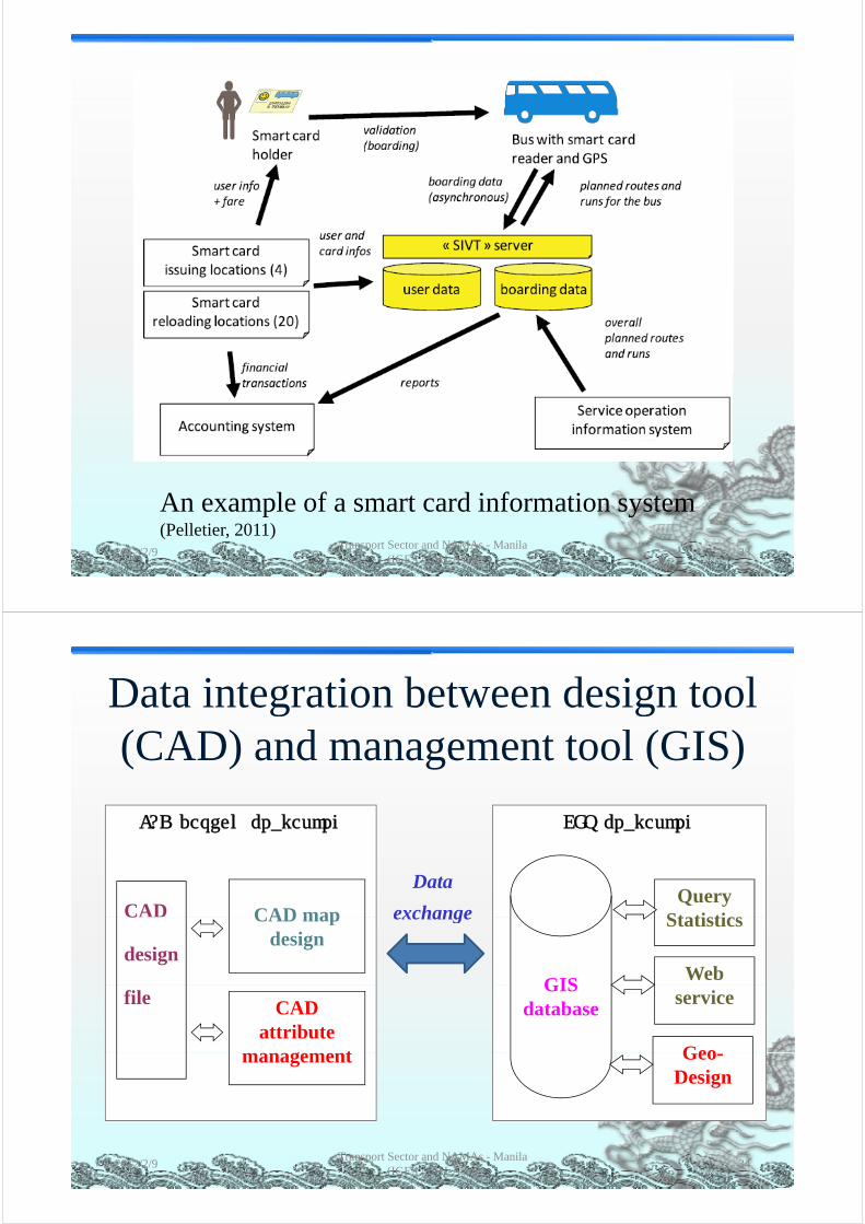
An example of a smart card information system
2012/2/9Transport Sector and NAMAs - Manila
(IGES / CAI-Asia)33
An example of a smart card information system (Pelletier, 2011)
Data integration between design tool g g(CAD) and management tool (GIS)
CAD design framework GIS framework
CAD mapQuery
Statistics
Data
exchangeCAD CAD map design
Statisticsexchange
Web GIS
C
design
CAD attribute
t
serviceGIS
databasefile
Geomanagement Geo-Design
2012/2/9 34Transport Sector and NAMAs - Manila
(IGES / CAI-Asia)
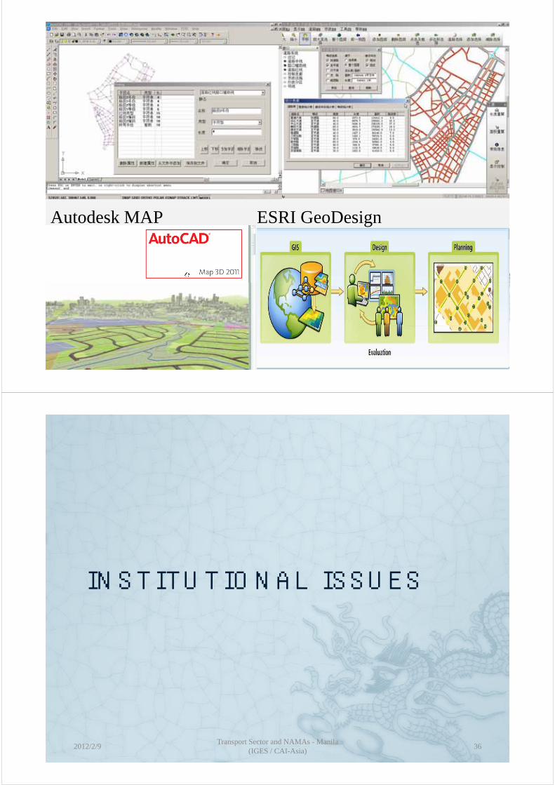
Autodesk MAP ESRI GeoDesign
2012/2/9Transport Sector and NAMAs - Manila
(IGES / CAI-Asia)35
INSTITUTIONAL ISSUESINSTITUTIONAL ISSUES
2012/2/9Transport Sector and NAMAs - Manila
(IGES / CAI-Asia)36

ChallengesChallenges
Largeamountsofsectordata Most data are regarded as confidential Mostdataareregardedasconfidential Difficulttoshare,wasteoftimeandmoney Nomechanismforpublicdatasharing
2012/2/9Transport Sector and NAMAs - Manila
(IGES / CAI-Asia)37
Urban transport administrative structure in China
Ministry of Public SecurityProvincial Government
Ministry of Construction
Provincial Dept. of Public Security Provincial Dept. of Construction
M i i l GMunicipal Government
Bureau of Traffic Management
Construction Committee
Planning Committee
Transport Committee
Bureau of Land Resource and Urban Planning
Institute of Planning and Design Institute of Transport PlanningInstitute of Survey and Mapping
Companies of Public Transport
Passenger Transport Management
2012/2/9Transport Sector and NAMAs - Manila
(IGES / CAI-Asia)38
y pp g
Administrative link Technical link

Groups shaping the urban transport system of Wuhan
The Construction Land Resource and Planning
Committee (CC)and Planning
Bureau (LRPB)
The Wuhan municipal
government
The Bureau of Public Security
(BPS)
The Planning Committee (PC)( )
The Transport The Statistical e spoCommittee (TC) Bureau (SB)
2012/2/9Transport Sector and NAMAs - Manila
(IGES / CAI-Asia)39
Institutional relationships on transport
Urban transport planning and management
Related agencies
LRPB:Transport planning
BTM:Traffic control PC:Transport planning
Land use controlUrban development
Traffic control Vehicle control
PC:Long-range planLarge projects
CC:
EPB:Emission control
CC:Annual road planConstruction marketRoad inventory
TC:Public transport
Inter-city transportSB:
Socio-economic
2012/2/9Transport Sector and NAMAs - Manila
(IGES / CAI-Asia)40
Road inventoryy pinfo
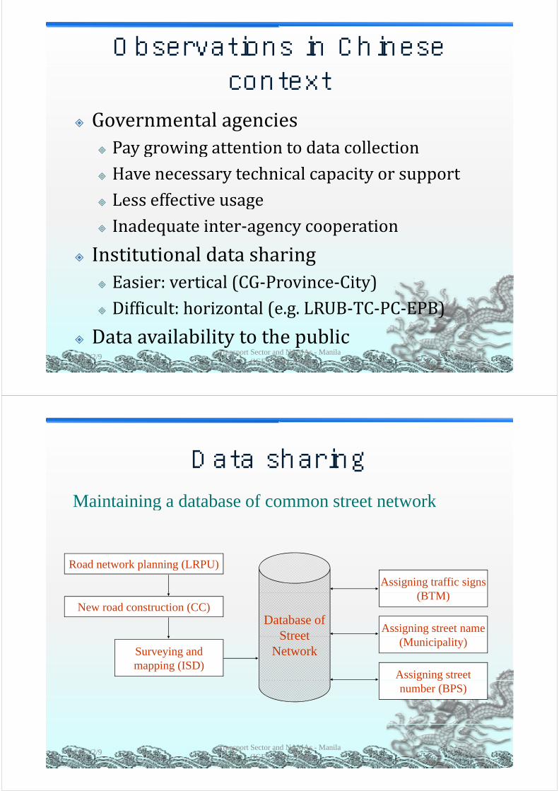
Observations in Chinese context
Governmentalagencies Paygrowingattentiontodatacollection y g g HavenecessarytechnicalcapacityorsupportLess effective usage Lesseffectiveusage
Inadequateinter‐agencycooperation
Institutionaldatasharing Easier: vertical (CG‐Province‐City) Easier:vertical(CG Province City) Difficult:horizontal(e.g.LRUB‐TC‐PC‐EPB)
Dataavailabilitytothepublic2012/2/9
Transport Sector and NAMAs - Manila (IGES / CAI-Asia)
41
Data sharingData sharingMaintaining a database of common street networkMaintaining a database of common street network
Road network planning (LRPU)
Assigning traffic signs (BTM)
New road construction (CC)(BTM)
Assigning street name Database of
Street
Assigning street
Surveying and mapping (ISD)
(Municipality)Street Network
g gnumber (BPS)
2012/2/9 42Transport Sector and NAMAs - Manila
(IGES / CAI-Asia)

R id t t l Household:
Transport modelling tasks
Data requirements Data sources
Resident travel demand
Household:Income
SizeOccupation
Age structure
Trip Generation:Regression;
LRPU:
IUTPAge structure
Trip Characteristics:Trip rate
Trip purpose
g ;Category…
Trip distribution:Gravity;
ISD
IUPD
p p pOrigin / Destination
Trip durationMode
TAZ:
Gravity;Intervening opport.;
Entropy…
Modal split:
BPU
BTMTAZ:Distances
Travel timeLand-use
classification
Diversion curve;Behavioural choice
BTM
SBclassification
Geographical locationLarge-scale attractionRoad network:Road segments / Links
Route assignment:Minimum; Stochastic;Equilibrium; Multi-path
BPS
CCand their connectivity
City:Total population
path…
Other Travel Demand:- Floating
CC
2012/2/9Transport Sector and NAMAs - Manila
(IGES / CAI-Asia)43
Total trip structureGDP
Socio-economic index
population;- Outward travellers;- Freight within city;- Outward freight
PC
TC
ACTIONS OF (TRANSPORT)ACTIONS OF (TRANSPORT) DATA SHARING
2012/2/9Transport Sector and NAMAs - Manila
(IGES / CAI-Asia)44

SDI: Spatial Data Infrastructure
GSDI
…topromoteawarenessand
USNSDI
thetechnology,policies,pimplementationofcomplimentarypolicies,
d d d
gy pstandards,andhumanresourcesnecessaryto
icommonstandards,andeffectivemechanismsforthedevelopment of interoperable
acquire,process,store,distribute,andimproveutilization of geospatialdevelopmentofinteroperable
digitalgeographicdataandtechnologiestosupport
utilizationofgeospatialdata
gdecisionmakingatallscalesformultiplepurposes.
2012/2/9Transport Sector and NAMAs - Manila
(IGES / CAI-Asia)45
Objectives of a Spatial Data Infrastructure
T d f d l TopromoteaccesstoandusageofdigitalgeospatialinformationofvaluetomultipleusersT i di f d bli ToimprovediscoveryofandpublicaccesstoprimarilygovernmentalgeospatialdataresourcesT d d li i f ff Toreduceduplicationofeffortamongcollaboratingorganizationsdeveloping,publishingand building applications on geospatial data andandbuildingapplicationsongeospatialdataandservicesusing open standards and accessible solutions…usingopenstandardsandaccessiblesolutions
2012/2/9 46Transport Sector and NAMAs - Manila
(IGES / CAI-Asia)
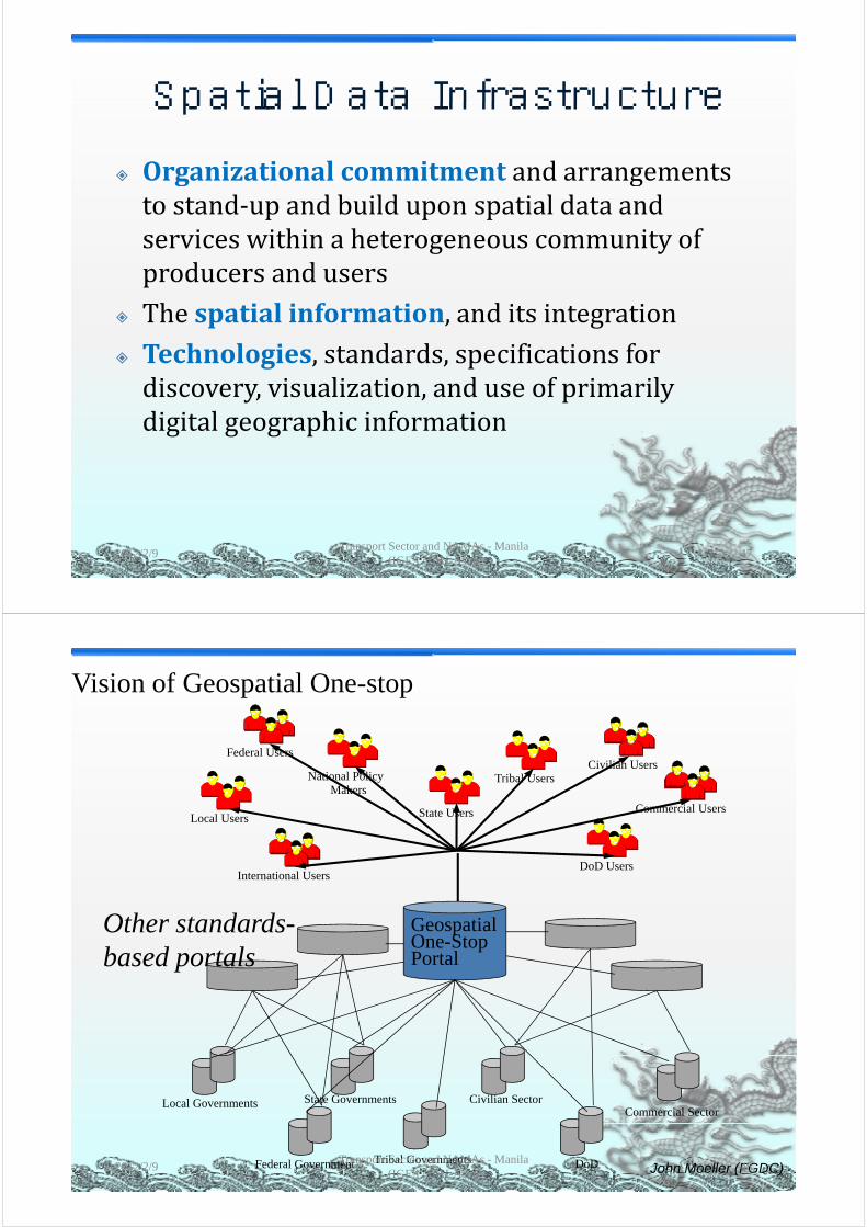
Spatial Data InfrastructureSpatial Data Infrastructure Organizational commitment and arrangements Organizationalcommitment andarrangementstostand‐upandbuilduponspatialdataandservices within a heterogeneous community ofserviceswithinaheterogeneouscommunityofproducersandusersTh ti l i f ti d it i t ti Thespatialinformation,anditsintegration
Technologies,standards,specificationsfordiscovery,visualization,anduseofprimarilydigitalgeographicinformation
2012/2/9 47Transport Sector and NAMAs - Manila
(IGES / CAI-Asia)
Vision of Geospatial One-stop
Tribal UsersNational PolicyCivilian Users
Federal Users
Local Users State Users
Makers
Commercial Users
DoD UsersInternational Users
G ti lOth t d d GeospatialOne-StopPortal
Other standards-based portals
Local Governments State Governments Civilian SectorCommercial Sector
Federal Government Tribal Governments DoD John Moeller (FGDC)2012/2/9 48Transport Sector and NAMAs - Manila
(IGES / CAI-Asia)

2012/2/9Transport Sector and NAMAs - Manila
(IGES / CAI-Asia)49
Transport Asset Data Integration: The Pennsylvania Experience
2012/2/9Transport Sector and NAMAs - Manila
(IGES / CAI-Asia)50http://www.fhwa.dot.gov/infrastructure/asstmgmt/dipatoc.cfm

2012/2/9Transport Sector and NAMAs - Manila
(IGES / CAI-Asia)51
Chinese national standard -urban geospatial dataurban geospatial data
sharingg Basicrequirementsforstandarddataoffundamentalgeographicinformation(GBg g p (21139‐2007)Standard for urban geospatial framework Standardforurbangeospatialframeworkdata(CJJ103‐2004)
Technicalstandard:urbangeospatialinformation infrastructure ‐ sharing serviceinformationinfrastructure sharingservicetechniques (CJ/T384‐2011,from2012‐05‐01)01)
2012/2/9Transport Sector and NAMAs - Manila
(IGES / CAI-Asia)52
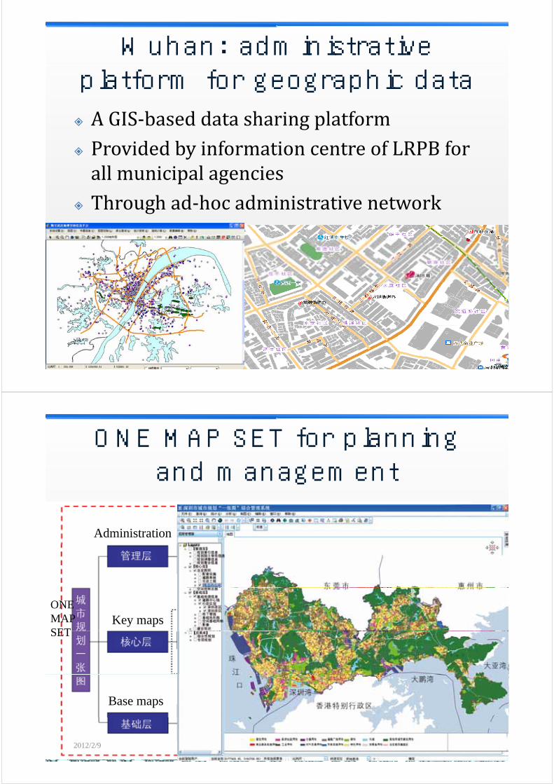
Wuhan: administrative platform for geographic data AGIS‐baseddatasharingplatform Provided by information centre of LRPB for ProvidedbyinformationcentreofLRPBforallmunicipalagenciesTh h d h d k Throughad‐hocadministrativenetwork
2012/2/9Transport Sector and NAMAs - Manila
(IGES / CAI-Asia)53
ONE MAP SET for planning and management
Administration
Key mapsONEMAPSETSET
Base maps
2012/2/9Transport Sector and NAMAs - Manila
(IGES / CAI-Asia)54
Liu, 2011

Concluding remarksConcluding remarks Dataisexploding:satelliteimage,traffic… Datafortransportgobeyondthesystemitselfp g y y Greatopportunityexistsforintegratingandstreamlining transport‐related data in a morestreamliningtransport relateddatainamoreefficientway
Effective data usage depend on Effectivedatausagedependon TechnicalimprovementInstitutional cooperation Institutionalcooperation
AjointeffortonONEplatform
2012/2/9 55Transport Sector and NAMAs - Manila
(IGES / CAI-Asia)
Zhengdong HuangWuhan UniversityyEmail: [email protected]
2012/2/9 56Transport Sector and NAMAs - Manila
(IGES / CAI-Asia)