ore bin / oregon geology magazine / journal · oregon geology is designed to reach a wide spectrum...
TRANSCRIPT
OREGON GEOLOGY published by the
• Oregon Department of Geology and Mineral Industries
VOLUME 49, NUMBER 11
50 · ANNIVERSARY
1937- 1987
•
NOVEMBER 1987
OREGON GEOLOGY (ISSN 0164-3304) VOLUME 49, NUMBER 11 NOVEMBER 1987 Published monthly by the Oregon Department of Geology and Mineral Industries (Volumes 1 through 40 were entitled The Ore Bin).
Governing Board Allen P. Stinchfield, Chair ...................... North Bend Donald A. Haagensen, ............................ Portland Sidney R. Johnson ................................. Baker
State Geologist ........................... Donald A. Hull Deputy State Geologist ................... John D. Beaulieu Publications Manager/Editor ............... Beverly F. Vogt Associate Editor ..................... Klaus K.E. Neuendorf
Main Office: 910 State Office Building, 1400 SW Fifth Ave., Portland 97201, phone (503) 229-5580.
Baker Field Office: 1831 First Street, Baker 97814, phone (503) 523-3133 Howard C. Brooks, Resident Geologist
Grants Pass Field Office: 312 SE "H" Street, Grants Pass 97526, phone (503) 476-2496 Len Ramp, Resident Geologist
Mined Land Reclamation Program: 1534 Queen Ave. SE, Albany 97321, phone (503) 967-2039 Gary W. Lynch, Supervisor
Second class postage paid at Portland, Oregon. Subscription rates: 1 year $6; 3 years, $15. Single issues, $.75 at counter, $1 mailed. Available back issues of Ore Bin: $.50 at counter, $1 mailed. Address subscription orders, renewals, and changes of address to Oregon Geology, 910 State Office Building, Portland, OR 97201. Permission is granted to reprint information contained herein. Credit given to the Oregon Department of Geology and Mineral Industries for compiling this information will be appreciated. POSTMASTER: Send address changes to Oregon Geology, 910 State Office Building, Portland, OR 97201.
Information for contributors Oregon Geology is designed to reach a wide spectrum of readers
interested in the geology and mineral industry of Oregon. Manuscript contributions are invited on both technical and general-interest subjects relating to Oregon geology. Two copies of the manuscript should be submitted, typed double-spaced throughout (including references) and on one side of the paper only. Graphic illustrations should be camera-ready; photographs should be black-and-white glossies. All figures should be clearly marked, and all figure captions should be typed together on a separate sheet of paper.
The style to be followed is generally that of U.S. Geological Survey pUblications (see the USGS manual Suggestions to Authors, 6th ed., 1978). The bibliography should be limited to "References Cited." Authors are responsible for the accuracy of the bibligraphic references. Names of reviewers should be included in the ''Acknowledgments.''
Authors will receive 20 complimentary copies of the issue containing their contribution. Manuscripts, news, notices, and meeting announcements should be sent to Beverly F. Vogt, Publications Manager, at the Portland office of DOGAMI.
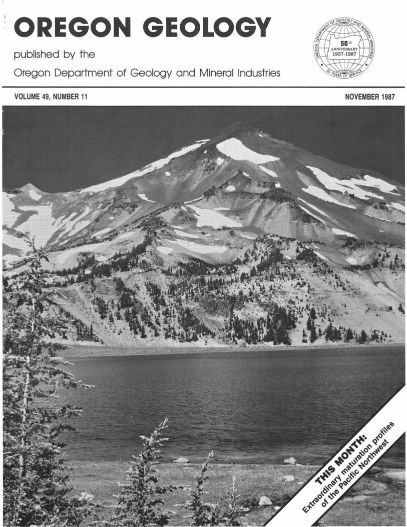
COVER PHOTO South Sister, one of the Cascade volcanoes, as seen look
ing west across the Green Lakes basin. Article beginning on next page suggests that thennal fluids associated with this type of volcanism may have assisted in the maturation of sedimentary units with respect to oil and gas generation throughout the Pacific Northwest. Photo courtesy Oregon State Highway Division.
134
OIL AND GAS NEWS ARCO remains active at Mist
ARCO has drilled the Columbia County 31-27-65 well to a total depth of 6,700 ft, which makes it a relatively rare test of the deeper sediments at Mist. Production casing was run on the well to a depth of 1,690 ft, and the well is currently suspended, awaiting completion. ARCO next drilled the Columbia County 31-34-65 well to a depth of 2,344 ft and has run production casing, and the well also is currently suspended, awaiting completion. ARCO is planning completion tests on both wells.
ARCO is currently drilling the Columbia County 34-4-65 well, the fifth well of ARCO's 1987 drilling program at Mist.
Damon plans conversion to water well Damon Petroleum plans to convert its Stauffer Fanns 35-1 well
in Marion County to a water well. This well was abandoned in September 1987 after an unsuccessful attempt to reenter and deepen it. The well was erroneously listed in the October issue of Oregon Geology under permit number 3W; the correct permit number is 358D. D
Republic, Wash., opens new fossil center The town of Republic, Washington, hosted an open house at its
new Stonerose Interpretive Center on August 18, 1987. Over 70 people attended the opening of this addition to the Republic town parks.
The Stonerose Interpretive Center is a small museum that houses a representative group of middle Eocene plant fossils and a few excellently preserved fish and insect fossils from the same strata as the Republic fossil flora. The Center is located adjacent to a major collecting site of the fossils it displays.
Important collections have been made here for a decade by Wes Wehr, Affiliate Curator of Paleobotany at the Burke Museum at the University of Washington, also by Kirk Johnson and Michael Spitz, with the help of several interested citizens of Republic. Wehr and Jack A. Wolfe, U.S. Geological Survey (USGS), recently completed a study of the Republic flora and published it in USGS Bulletin 15W (1987).
Madilane Perry, Curator of the Stone rose Interpretive Center, explained that the town's recent acquisition of the fossil site was a major stimulus to create the Interpretive Center. She hopes the Center will bring a new attraction to this town of fonner gold-mining glory.
From November 20 until (probably) mid-May, the Center will be closed. However, Curator Perry will answer mail inquiries. For more infonnation, contact Madilane Perry, Stonerose Interpretive Center, P.D. Box 987, Republic, WA 99166, phone (509) 775-2295; or the Republic Town Hall office, phone (509) 775-3216.
-Melvin S. Ashwill, Madras
U.S. POSTAL SERVICE STATEMENT OF OWNERSHIp, MANAGEMENT, AND CIRCULATION
Publication title: OREGON GEOLOGY, no. 600040; filing date 9-30-87. Published monthly, 12 issues per year, annual subscription price $6. Address of publication office, publisher's business office, editor, and owner: 910 State Office Building, 1400 SW 5th Ave., Portland, OR 97201-5528. Publisher and owner: Oregon Department of Geology and Mineral Industries; editor: Beverly F. Vogt. No managing editor or bondholders. Circulation during last 12 months/of single issue, respectively: Net press run 3083/3000; paid circulation est. 200/200; mail SUbscription 1543/1618; total paid circulation 1743/1818; free distribution 400/350; total distribution 2143/2168; not distributed 940/832; return 0/0; total 3083/3000. I certify that the sta~ents made by me above t~ct and complete. t:)..f.,u ,,~ a,. c/~ , Publications Manager
OREGON GEOLOGY, VOL. 49, NO. 11, NOVEMBER 1987

Extraordinary maturation profiles of the Pacific Northwest by Neil S. Summer, Department of Geology, Hebrew University, Jerusalem, Israel; and Kenneth L. Tlerosub, Geology Department, University of California, Davis, C4 95616
ABSTRACT Unusually steep maturation profiles from over thirty drill holes
spread throughout the Pacific Northwest imply near-constant maturity with respect to oil and gas over thousands of feet of sediment. Given the consistency of the data, the widespread occurrence of this type of maturation anomaly must be inferred to be a real and systematic phenomenon. In addition, the diverse sources of data and the qualitative agreement among the major maturation indicators support the model of a real maturation process that may be unique to such a geologically active area. Examination of the stratigraphy and maturation profiles of individual drill holes in the Pacific Northwest leads to the conclusion that the dominant maturation process is related to hydrothermal fluids associated with volcanic activity. This hypothesis implies that the source of the gas in the Mist Gas Field, Columbia County, Oregon, may be located in intruded sediments to the northeast and northwest of the field. In addition, vitrinite reflectance data from the Pacific Northwest cannot be interpreted using conventional models such as the Lopatin method, as short-term thermal events have overprinted the maturation data. Therefore an approach based on the concept of an "oil window" may be more appropriate, given the complex geological histories of basins within a tectonically active area such as the Pacific Northwest.
INTRODUCTION Consideration of all of the available data from the Pacific North
west reveals a pattern of anomalous maturation profiles that defy conventional interpretation. These unusual profiles are very steep, implying near-constant maturity with respect to oil and gas generation over thousands of feet of sediment. In this paper we examine the data and address the question of whether the anomalous profiles represent a real phenomenon.
MATURATION METHODS Various organic geochemical methods are commonly used to
ascertain the maturity and source rock potential of a sediment. These methods are used mainly to define the zone of peak hydrocarbon generation in source rocks so that updip reservoir rocks can be targeted for drilling. One such method, vitrinite reflectance (Ro), comprises the bulk of the maturation data on sediments in the Pacific Northwest. Vitrinite reflectance is based on the changes in the optical properties of vitrinite, which occur primarily in response to heating. During heating, the chemical composition of the organic matter in a sediment is irreversibly altered by a cracking process that generates volatile products such as CH4 and H2O. Cracking causes the organic matter molecules to restructure with a higher degree of order, increasing their reflectance. Vitrinite is one component of organic matter, and its reflectance increases in a uniform manncr. Initially used to evaluate coal rank, vitrinite reflectance is now the most widely used optical technique in the petroleum industry for determining the maturity of a source rock.
The vitrinite reflectance technique has been developed over many years. International standards now define most of the steps in the acquisition of data (Baskin, 1979), although different approaches are used for the extraction of the organic matter and the subsequent preparation of polished sections. When vitrinite reflectance values are plotted on a logarithmic scale versus depth on a linear scale, the result is usually a straight line of increasing reflectance with depth (Dow and O'Connor, 1982). Deviation from a uniform slope can provide important geological information. For example, the loca-
OREGON GEOLOGY, VOL. 49, NO. 11, NOVEMBER 1987
Okanogan Highlands
WASHINGTON
Figure 1. Physiography and location of drill holes in the Pacific Northwest with available maturation data. Numbered drill holes are keyed to well names and locations in Table 1.
tion of an unconformity and the amount of section removed at the unconformity is commonly obtained by extrapolating the vitrinite reflectance profile back to Ro = 0.2 percent at the paleo surface (Dow and O'Connor, 1982). There are two methods for interpreting the thermal history of sediments using vitrinite reflectance data: (I) conventional approaches based on time/temperature relationships, one being the Lopatin technique (Waples, 1980); and (2) an approach that treats vitrinite reflectance as an absolute geothermometer (Price, 1983; Barker and Pawlewicz, 1986).
Over the past decade, extensive studies by the petroleum industry have resulted in a cross-calibration of vitrinite reflectance with two other maturation indicators. The Thermal Alteration Index (TAl), a well-established method, is based on the color changes that organic particles experience with increasing maturation or temperatures (Staplin, 1982). Rock-Eval pyrolysis is based on the release of volatiles during heating of whole-rock samples and provides information on thermal maturation (Tmax) as well as the quantity and type of organic matter in the sediment. Rock-Eval pyrolysis has become accepted by the petroleum industry as a rapid, quantitative method for source rock evaluation.
TECHNIQUE LIMITATIONS Although vitrinite reflectance is a widely used and accepted in
dicator of thermal maturation, there are problems associated with the technique. First, the method is subjective because the microscope operator must identify and measure only unweathered, unoxidized vitrinite, and the ability to do this is a function of the operator's
135
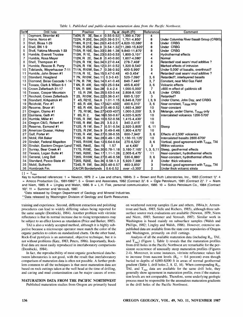
Table 1. Published and public-domain maturation data from the Pacific Northwest.
Ref# Drill hole Position Ro at depth (Ft) Reference Comment 1 Daymont, Stremler #2 T40N, R 3E, Sec.4 0.55-0.52 1,390-4,720' 4 2 Norco, Norco #1 T22N, R 20E, Sec.26 0.39-0.51 1,751-4,850' 8 Under Columbia River Basalt Group (CRBG) 3 Shell, Bissa 1-29 T18N, R 21 E, Sec.29 0.43-0.57 4,620-10,080' 8 Under CRBG 4 Shell, BN 1-9 T15N, R 25E, Sec.9 0.54-1.32 11,280-15,820' 8 Under CRBG 5 Shell, Yakima Minerals 1-33 T15N, R 19E, Sec.33 0.86-1.38 9,840-11,870' 8 Under CRBG 6 Humble, Everett Trustee T13N, R 1E, Sec.23 0.63-0.53 1,800-3,101 ' 4 Hydrothermal effects 7 Humble, Rosa Meyer T12N,R 2E, Sec.8 0.40-0.60 1,607-4,080' 4 Nonnal 8 Shell, Thompson #1 T12N, R lW, Sec.34 0.27-0.44 278-7,468' 3 Retarded! coal seam! mud additive ? 9 Humble, Roscoe B. Perry T12N, R lW, Sec.12 0.31-0.52 1,320-9,540' 4 Marked effects of intrusion 10 Tidelands, Weyerhauser 7-11 Tll N, Rl0W, Sec.7 0.38-0.92 400-5,990' 3 Under 5,000' of basalts, overthrust? 11 Humble, John Brown #1 Tl1N, R lE, Sec.15 0.47-0.48 40-3,454' 4 Retarded! coal seam! mud additive? 12 Standard, Hoagland T7N, Rl0W, Sec.l1 0.3-0.43 520-7,090' 3, 6 Retarded?, interlayered basalts 13 Diamond, Boise Cascade 1-14 T 7N, R 7W, Sec.14 0.41-0.46 840-7,440' 3, 7 Constant, near Mist Gas Field 14 Texaco, Clark & Wilson 6-1 T 6N, R 4W, Sec.19 0.25-0.64 485-8,405' 3, 6 Volcanic effects 15 Crown Zellerbach 31-17 T 5N, R 9W, Sec.28 0.4-2.4 1,000-5,000' 7 +600 m effect of gabbroic sill 16 Texaco, Cooper Mountain T 1S, R 2W, Sec.25 0.63-0.44 2,808-8,100' 3, 6 Under CRBG 17 Reichold, Crown Zellerbach T 2S, R10W, Sec.22 0.36-0.41 680-5,120' 3 Retarded? 18 Standard, Kirkpatrick #1 T 4S, R21 E, Sec.6 1.01-1.15 6,846-8,720' 1,3,9 Under Clarno, John Day, and CRBG 19 Reichold, Finn #i T 6S, R 4W, Sec.17 [421-433] 490-6,310' 3,6 Near-constant, T max only 20 Reserve, Bruer #1 T 6S, R 4W, Sec.31 0.46-0.52 1,660-4,380' 10 Near-constant 21 Oregon, Clarno #1 T 7S, R19E, Sec.27 [433-437] 1,000-3,200' 3, 9 Melange, under Clarno, T max only 22 Quintana, Gath #1 T 8S, R 2, Sec.16 0.50-0.67 4,020-5,925' 10 Intercalated volcanics 1200-5"700' 23 Humble, Miller #1 T10S, R 3W, Sec. 1 0 0.52-0.56 1,415-4,430' 10 24 Oregon O&G, Robert #1 Tl0S, R 8W, Sec.25 3.5-2.5 340-2,415' 10 25 Reserve, Esmond #1 T12S, R lW, Sec.7 0.51-0.54 2,920-3,805' 6, 11 Steep 26 American Quasar, Hickey T12S, R 2W, Sec.9 0.49-0.46 1,800-4,670' 10 27 Gulf, Porter #1 T13S, R 4W, Sec.27 0.38-0.55 600-7,940' 3, 6 Effects of 2,500' volcanics 28 Mobil, IRA Baker T15S, R 3W, Sec.28 0.49-1.26 1,130-10,125' 10 Intercalated basalts 2800-6700' 29 Sinclair, Federal-Mapelton T16S, R10W, Sec.12 0.64-0.64 270-6,520' 3, 6 Vertical, good agreement with T max, TAl 30 Sinclair, Eastern Oregon Land T16S, R44E, Sec.15 1.57 at 4,430' 3 Within volcanics 31 Sunray, Bear Creek #1 T17S, R19E, Sec.30 0.78-1.18 3,180-7,165' 1,3,5,11 Steep, geothermal effects 32 Texaco, Logan Butte #1 T19S, R20E, Sec.17 1.11-1.26 2,005-6,475' 11 Near-constant, hydrothermal effects 33 General, Long Bell T20S, R10W, Sec.27 0.46-0.58 530-6,880' 3, 6 Near-constant, hydrothermal effects 34 Standard, Pexco State #1 T20S, R20E, Sec.36 0.58-1.3 5,920-7,386' 3 Under thick volcanics 35 Mobil, Sutherlin T24S, R 5W, Sec.36 0.48-0.57 460-3,850' 3 Vertical, good agreement with T max, TAl 36 Hornbrook Fm. CAlOR Borderlands 0.6-0.52 over ~,300' 2 Under thick volcanic strata
[I = T max
Key to numbered references: 1 = Newton, 1979. 2 = Law and others, 1984b. 3 = Brown and Ruth Laboratories, Inc., 1983 (Contract 1)*. 4 = Amoco Production Co., 1981-1983**. 5 = Green and Associates, 1982 (Contract 3)*. 6 = Ogle Petroleum, 1981 (Contract 2)*. 7 = Niem and Niem, 1985. 8 = Lingley and Walsh, 1986. 9 = L.H. Fisk, personal communication, 1986. 10 = Sohio Petroleum Co., 1984 (Contract 10)*. 11 = Summer and Verosub, 1987.
*Data released by Oregon Department of Geology and Mineral Industries. **Data released by Washington Division of Geology and Earth Resources.
training and experience. Second, differcnt extraction and polishing procedures can lead to widely differing values being reported for the same sample (Dembicki, 1984). Another problem with vitrinitc reflectance is that its normal increase due to rising temperatures may be subjcct to an effect known as rctardation (Pricc and Barker, 1985).
TAl is also a widely accepted method, although it is highly subjective because a microscope operator must match the color of the organic particles to colors on standardized charts. On the other hand, Rock-Eva! pyrolysis is an automated, objective technique, but it is not without problems (Katz, 1983; Peters, 1986). Importantly, RockEval data are most easily reproduced in interlaboratory comparisons (Dembicki, 1984).
In fact, the reproducibility of most organic geochemical data between laboratories is not good, with the result that interlaboratory comparison of maturation data is often not possible. A further problem common to all the techniques is that most maturation data are based on rock cuttings taken at the well head at the time of drilling, and caving and mud contamination can be major causes of error.
MATURATION DATA FROM THE PACIFIC NORTHWEST Published maturation studies from Oregon are primarily based
136
on weathered outcrop samples (Law and others, 1984a,b; Armentrout and Suek, 1985; Sidle and Richcrs, 1985), although three subsurfacc source rock evaluations are available (Newton, 1979; Niem and Niem, 1985; Summer and Verosub, 1987). Similar work in Washington is based mainly on subsurface samples (Walsh and Phillips, 1982; Lingley and Walsh, 1986). However, extensivc unpublished data are available from the state core repositories of Oregon and Washington, primarily on drill cuttings.
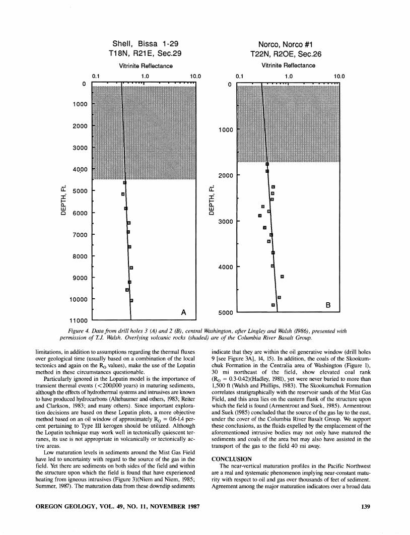
Analysis of all the available maturation data (including Ro, TAl, and T max) (Figure 1, Table 1) reveals that the maturation profiles from drill holes in the Pacific Northwest are remarkable for the persistent occurrence of unusually steep maturation profiles (Figures 2-4). Moreover, in some instances, vitrinite reflectance values fail to increase from nascent levels (Ro = 0.4 percent) even though buried to depths of 6,000-8,000 ft in areas of normal geothermal gradient (Table \, drill holes 2, 8, 12, 14). When corresponding Ro, TAl, and T max data are available for the same drill hole, they generally show agreement in maturation profile, even if the maturation levels are not comparable. Therefore, some underlying geologic process must be responsible for the anomalous maturation gradients in the drill holes of the Pacific Northwest.
OREGON GEOLOGY, VOL. 49, NO. 11, NOVEMBER 1987
DISCUSSION. We will not attempt to examine in detail the available data, given
the fact that maturation data from different laboratories cannot be directly compared. For example, consistent with Dembicki (1984), the four independent studies on a drill hole in north-central Oregon (Figures 2A,B) indicate significantly different maturation levels. More importantly, however, the profiles or best-fit lines for each data set are all anomalously steep, showing that all of the studies are consistent in implying an unusual maturation process. Further examination of the data base reveals that the unusual maturation profiles that prevail within most of the drill holes in the Pacific Northwest are independent of the laboratories that generated the data. Therefore, given the widespread occurrence of drill holes with steep maturation profiles, the diverse sources of the data, and the agreement between the different maturation techniques, the profiles are
interpreted to be real and not the result of some methodological error. As previously mentioned, in some individual drill holes, vitrinite
reflectance levels are remarkably low, compared to TAl and T max
results. One possibility is that the results are due to retardation of vitrinite reflectance. This has been reported to occur in sediments with appreciable amounts of exinite or hydrogen-rich Type II kerogens (Price and Barker, 1985). However, the sediments of the Pacific Northwest generally have low hydrogen contents probably due to an aerobic depositional environment (Armentrout and Suek, 1985), and Type II kerogen does not predominate. While retardation may account for some anomalously low vitrinite reflectance data in central Washington (drill hole 2), near the Mist Gas Field in northwest Oregon (drill holes 12, 13, 14), and elsewhere (drill holes 6, 8) where Type II hydrogen-rich strata occur, it cannot be shown to have occurred systematically over the data base.
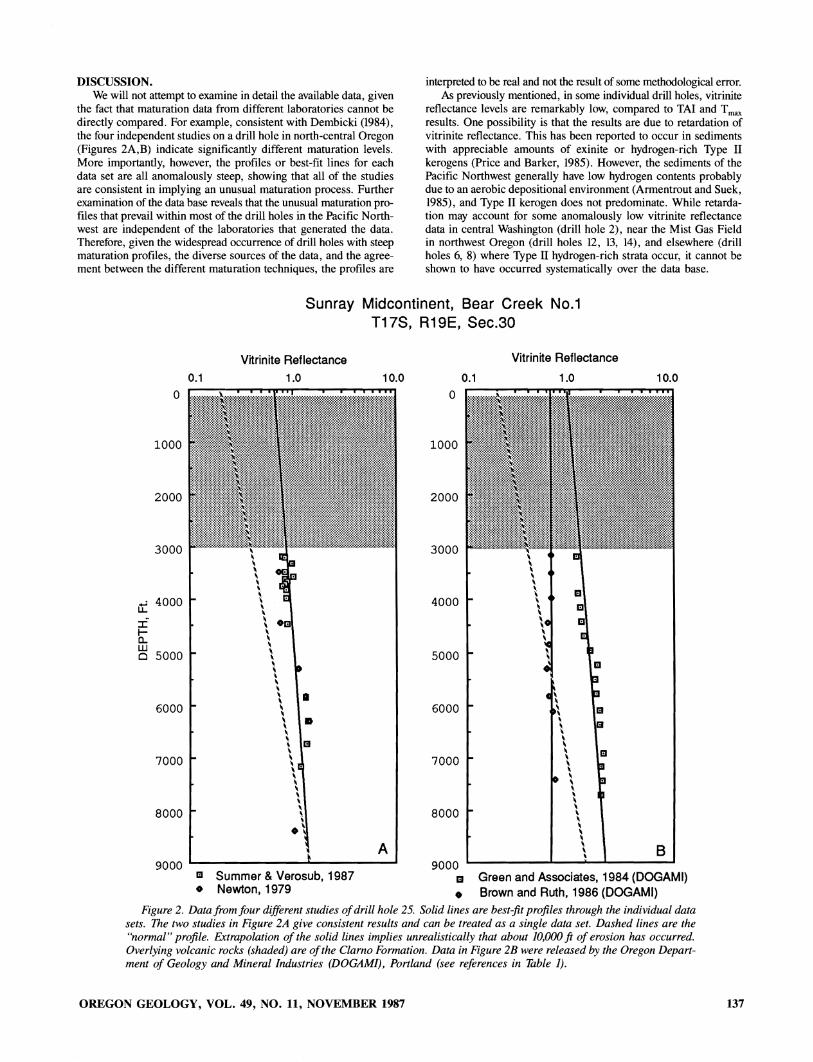
Sunray Midcontinent, Bear Creek No.1 T17S, R19E, Sec.30
o
1000
2000
3000
u:: 4000
:i" I-a... w c 5000
6000
7000
8000
9000
0.1
Vitrinite Reflectance 1.0
•
III Summer & Verosub, 1987 • Newton, 1979
10.0
A
o
1000
2000
3000
4000
5000
6000
7000
8000
9000
0.1
Vitrinite Reflectance
1.0 10.0
III Green and Associates, 1984 (DOGAMI) • Brown and Ruth, 1986 (DOGAMI)
Figure 2. Data from four different studies of drill hole 25. Solid lines are best-fit profiles through the individual data sets. The two studies in Figure 2A give consistent results and can be treated as a single data set. Dashed lines are the "normal" profile. Extrapolation of the solid lines implies unrealistically that about 10,000 ft of erosion has occurred. Overlying volcanic rocks (shaded) are of the Clarno Formation. Data in Figure 2B were released by the Oregon Department of Geology and Mineral Industries (DOGAMI), Portland (see references in Table 1).
OREGON GEOLOGY, VOL. 49, NO. 11, NOVEMBER 1987 137

Ii I I-0... W o
o
2000
4000
6000
8000
10000
Humble, Roscoe B. Perry T12N,R1W, Sec.12
0.1
Vitrinite Reflectance
1.0
III
III
11 III III III
III III
III III
III III
~ III III
iii
I!I
III A
10.0
o
1000
2000
Ii ::I:
3000 I-0... LU 0
4000
5000
6000
Crown Zellerbach 31-17 T5N, R9W, Sec.28
0.1
Vitrinite Reflectance
1.0
III
EI
I!I
EI EI
I!I
10.0
:::i:i:i:i:i:i:i:i:~i:i:Mi[:~li!lmlUl~n_l:ii:i~:i:li:i:i:i:i:ir~i::i:i:i:i: mmmmtmm~mmmmmf~1~~~f:milim1~~l@t~mm~ttlii~1:i~1~m111ji~1
Figure 3. Data from southwest Washington (A = drill hole 9) and northwest Oregon (B = drill hole 15). Drill holes are less than 40 mi from the Mist Gas Field. Oregon. Data in A are from a study by Amoco Production Co. and released by the Washington Division of Geology alld Earth Resources. Olympia (see reference in Table 1). Data in B are from Niem and Niem. 1985. The intrusive bodies (shaded) have not been named or dated at the present time.
Anomalous maturation profiles in the Pacific Northwest drill holes generally occur where sediments are mantled or intruded by volcanic rocks, although in some instances no volcanic rocks are present (drill holes 1, Tl). Intrusive and extrusive volcanic rocks are known to have a direct thermal effect on country rock, but these effects arc overshadowed by associated hydrothermal effects. We have suggested that the unusual near-constant maturation profiles are the result of the thermal effects of hydrothermal aquifers perched high in the rock column (Summer and Verosub, 1987). Such aquifers can be found in any highly permeable strata, and fractured volcanic rocks as well as porous sediments can provide the necessary conduits. These aquifers can be wide-ranging in extent, and their thermal effects on underlying sediments have been simulated by Ziagos and Blackwell (1981) and documented by Wood and Low (1986).
Thermal fluids from generations of Cascade volcanism may have affected a wide area (Walsh and Phillips, 1982), and there is evidence that emplacement of the Columbia River Basalt Group was preceded by a thermal event with coincident hydrothermal activity east
138
of the Cascades (Summer and Verosub, 1987). Thus, marked maturation perturbations (drill holes 6,9, 15,22. 26) and extensive evidence of fossil hydrothermal systems suggest that fluids associated with intrusive and extrusive bodies have assisted in the maturation of sedimentary units throughout the Pacific Northwest. This mechanism thus implies a much wider diagenetic influence of intrusive activity, well beyond contact metamorphic effects (Summer, 1987).
The anomalous maturation profiles cannot be explained using conventional techniques used to integrate the effects of temperature and time on organic maturation. For example, the widely used Lopatin method is based on a calculated time-temperature interval (TTl) derived solely from vitrinite reflectance data (Waples. 1980). Because of the assumptions of the method, the Lopatin technique cannot account for strata of different geological age with the same TTL To do so would require that the sedimentary units had been subject to downwardly decreasing temperatures. In addition, the maximum burial depth usually obtained from extrapolation of the vitrinite reflectance profile gives unrealistic values (Figures 2A,B). These
OREGON GEOLOGY, VOL. 49, NO. 11, NOVEMBER 1987
u:: ~ e.. w o
o
1000
2000
3000
40.00
5000
6000
7000
8000
9000
10000
11000
0.1
Shell, Bissa 1-29 T18N, R21 E, Sec.29
Vitrinite Reflectance
1.0
A
10.0
u:: :C l-e.. w 0
0.1
a
1000
2000
3000
4000
5000
Norco, Norco #1 T22N, R20E, Sec.26
Vitrinite Reflectance
1.0
EI
EI
III
III
10.0
B
Figure 4. Data from drill holes 3 (A) and 2 (B), central Washington, after Lingley and Walsh (1986), presented with permission of T.]. Illilsh. Overlying volcanic rocks (shaded) are of the Columbia River Basalt Group.
limitations, in addition to assumptions regarding the thermal fluxes over geological time (usually based on a combination of the local tectonics and again on the Ra values), make the use of the Lopatin method in these circumstances questionable.
Particularly ignored in the Lopatin model is the importance of transient thermal events ( < 200,000 years) in maturing sediments, although the effects of hydrothermal systems and intrusives are known to have produced hydrocarbons (Altebaumer and others, 1983; Reiter and Clarkson, 1983; and many others). Since important exploration decisions are based on these Lopatin plots, a more objective method based on an oil window of approximately Ra = 0.6-1.4 percent pertaining to Type III kerogen should be utilized. Although the Lopatin technique may work well in tectonically quiescent terranes, its use is not appropriate in volcanically or tectonically active areas.
Low maturation levels in sediments around the Mist Gas Field have led to uncertainty with regard to the source of the gas in the field. Yet there are sediments on both sides of the field and within the structure upon which the field is found that have experienced heating from igneous intrusives (Figure 3)(Niem and Niem, 1985; Summer, 1987). The maturation data from these downdip sediments
OREGON GEOLOGY, VOL. 49, NO. 11, NOVEMBER 1987
indicate that they are within the oil generative window (drill holes 9 [see Figure 3A], 14, 15). In addition, the coals of the Skookumchuk Formation in the Centralia area of Washington (Figure 1), 30 mi northeast of the field, show elevated coal rank (Ra = 0.3-0.42)(Hadley, 1981), yet were never buried to more than 1,500 ft (Walsh and Phillips, 1983). The Skookumchuk Formation correlates stratigraphically with the reservoir sands of the Mist Gas Field, and this area lies on the eastern flank of the structure upon which the field is found (Armentrout and Suek, 1985). Armentrout and Suek (1985) concluded that the source of the gas lay to the east, under the cover of the Columbia River Basalt Group. We support these conclusions, as the fluids expelled by the emplacement of the aforementioned intrusive bodies may not only have matured the sediments and coals of the area but may also have assisted in the transport of the gas to the field 40 mi away.
CONCLUSION The near-vertical maturation profiles in the Pacific Northwest
are a real and systematic phenomenon implying near-constant maturity with respect to oil and gas over thousands of feet of sediment. Agreement among the major maturation indicators over a broad data
139

base suggests a real maturation process that may be unique to such a geologically active area, namely thermal input from warm-water aquifers within the sedimentary column. Given the widespread effects of such aquifers and their effects on underlying sediments, the systematic occurrence of near-constant maturation profiles throughout the area should be expected.
Understanding the unusual maturation processes is made more difficult by problems with the major maturation indicators and the fact that data from different sources are not amenable to direct comparison. However, examination of the stratigraphy and maturation profile of individual drill holes leads to the conclusion that the maturation process is related to hydrothermal fluids associated with volcanic activity. Furthermore, hitherto unpublished data indicate that the source of the gas in the Mist Gas Field may lie in intruded sediments to the northeast and northwest.
Interpretation of the vitrinite reflectance data from the Pacific Northwest cannot be done in the conventional manner because such methods cannot accommodate short-term thermal events. As an alternative method of interpreting the unusual maturation data from the Pacific Northwest, an approach based on the established "oil window" is more appropriate, given the complex geological histories of basins within such a tectonically active area.
ACKNOWLEDGMENTS This paper was improved by critical reviews by K.E. Peters, M.l
Pawlewicz, R. Harding, A. Daley, T.l Walsh, and D.E. Wermiel. The bulk of the data used in this paper was released to us by the Core Repositories of the States of Oregon and Washington, and we thank D.E. Wermiel and T.J. Walsh for their assistance.
This research was supported by Grant EAR-84-0836l from the National Science Foundation and a grant from the University-wide Energy Research Group to K.L.Y.
REFERENCES CITED Altebaumer, FJ., Leythaeuser, D., and Schafer, R.G., 1983, Effect of
geologically rapid heating on maturation and hydrocarbon generation in lower Jurassic shales from NW Germany, in Bjoroy, L., and others, eds., Advances in organic geochemistry 1981: New York, Wiley and Sons, p. 80-86.
Armentrout, 1M., and Suek, D.H., 1985, Hydrocarbon exploration in western Oregon and Washington: American Association of Petroleum Geologists Bulletin, v. 69, no. 4, p. 627-643.
Barker, C.E., and Pawlewicz, M.l, 1986, The correlation of vitrinite reflectance with maximum paleotemperature in humic organic matter, in Buntebarth, G., and Stegena, L., eds., Paleogeothermics: New York, Springer, p. 79-93.
Baskin, 1979, A method of preparing phytoclasts for vitrinite reflectance analysis: Journal of Sedimentary Petrology, v. 49, p. 633-635.
Dembicki, H., Jr., 1984, An interlaboratory comparison of source rock data: Geochimica et Cosmochimica Acta, v. 48, p. 2641-2649.
Dow, w.G., and O'Connor, D.l., 1982, Kerogen maturity and type by reflected-light microscopy applied to petroleum exploration, in Staplin, EL., ed., How to assess maturation and paleotemperatures: Society of Economic Paleontologists and Mineralogists Short Course Notes 7, p. 133-157.
Katz, 8.1, 1983, Limitations of Rock-Eval pyrolysis for typing organic matter: Organic Geochemistry, v. 4, p. 195-199.
Law, 8.E., Anders, D.E., Fouch, T.D., Pawlewicz, MJ., Lickus, M.R., and Molenaar, C.M., 1984a, Petroleum source rock evaluations of outcrop samples from Oregon and northern California: Oregon Geology, v. 46, no. 7, p. 77-81.
Law, 8.E., Anders, D.E., and Nilsen, T.H., 1984b, The petroleum source rock potential of the Upper Cretaceous Hornbrook Formation, northcentral California and southwestern Oregon, in Nilsen, T.H., ed., Geology of the Upper Cretaceous Hornbrook Formation, Oregon and California: Society of Economic Paleontologists and Mineralogists, Pacific Section, Field Trip Guidebook 42, p. 133-140.
Lingley, W.S., Jr., and Walsh, TJ., 1986, Issues relating to petroleum drilling near the proposed high-level nuclear waste repository at Hanford: Washington Geologic Newsletter, v. 14, no. 3, p. 10-19.
140
Newton, v.e., Jr., 1979, Petroleum source rock tests on two central Oregon wells: Oregon Geology, v. 41, no. 4, p. 63-64.
Niem, A.R., and Niem, W.A., 1985, Oil and gas investigation of the Astoria basin, Clatsop and northernmost Tillamook Counties, northwest Oregon: Oregon Department of Geology and Mineral Industries Oil and Gas Investigation 14, 8 p., 2 pis.
Peters, K.E., 1986, Guidelines for evaluating petroleum source rock using programmed pyrolysis: American Association of Petroleum Geologists Bulletin, v. 70, no. 3, p. 318-329.
Price, L.e., and Barker, e.E., 1985, Suppression of vitrinite reflectance in amorphous rich kerogen-a major unrecognized problem: Journal of Petroleum Geology, v. 8, no. 1, p. 59-84.
Reiter, M., and Clarkson, G., 1983, Relationships between heat flow, paleotemperatures, coalification, and petroleum maturation in the San Juan Basin, northwest New Mexico and southwest Colorado: Geothermics, v. 12, no. 4, p. 323-339.
Sidle, w.e., and Richers, D.M., 1985, Geochemical reconnaissance of Cretaceous inliers in north-central Oregon: American Association of Petroleum Geologists Bulletin, v. 69, no. 3, p. 412-421.
Summer, N.S., 1987, Maturation, diagenesis, and diagenetic processes in sediments underlying thick volcanic strata, Oregon: Davis, Calif., University of California master's thesis, 87 p.
Summer, N.S., and Verosub, K.L., 1987, Maturation anomalies in sediments underlying thick volcanic strata, Oregon: Evidence for a thermal event: Geology, v. 15, no. 1, p. 30-33.
Walsh, TJ., and Phillips, W.M., 1982, Coal rank and thermal maturation in King COUlity, Washington: Washington Geologic Newsletter, v. 10, no. 1, p. 9-18.
---1983, Rank of Eocene coals in western and central Washington State-a reflection of Cascade plutonism?: Washington Division of Geology and Earth Resources Open-File Report 83-16, 23 p.
Waples, OW., 1980, Time and temperature in petroleum formation: Application of Lopatin's method to petroleum exploration: American Association of Petroleum Geologists Bulletin, v. 64, no. 6, p. 916-926.
Wood, WW., and Low, W.H., 1986, Aqueous geochemistry and diagenesis in the eastern Snake River Plain aquifer system, Idaho: Geological Society of America Bulletin, v. 97, no. 12, p. 1456-1466.
Ziagos, IP., and Blackwell, D.O., 1981, A model for the effect of horizontal fluid flow in a thin aquifer on temperature-depth profiles: Geothermal Resources Council Transactions, v. 5, p. 221-223. D
New map describes geology of Breitenbush River area
The complex volcanic geology of the Breitenbush River area is described and discussed in a new publication of the Oregon Department of Geology and Mineral Industries (DOGAMI). The area is located at the transition between the older Western Cascade Range and the younger High Cascade Range and has been known for its thermal springs and, in some parts, for its mineral potential.
Geologic Map of the Breitenbush River area, Linn and Marion Counties, Oregon, by DOGAMI staff geologists G.R. Priest, N.M. Woller, and M.L. Ferns, has been released in DOGAMI's Geological Map Series as map GMS-46. It covers over 200 square miles, extending from Detroit Lake 12 miles to the east and from Hawk Mountain in the north to Bachelor Mountain in the south.
The report consists of two parts, a map sheet and a 4-page text. The map sheet (approximately Ll by 40 inches) contains a multicolored geologic map (scale 1:62,500), a geologic cross section, a location map, and a table listing ages of almost 50 samples from the area. The map explanation identifies and describes 50 separate units of surficial and volcanic rocks, vent complexes, and intrusives. The accompanying text discusses the structural geology, mineralization, and geothermal resources of the study area and presents a table of radiometric data for some rock-unit samples collected outside the map area.
The new map GMS-46 is now available at the Oregon Department of Geology and Mineral Industries, 910 State Office Building, 1400 SW Fifth Avenue, Portland, OR 97201. The purchase price is $6. Orders under $50 require prepayment. D
OREGON GEOLOGY, VOL. 49, NO. 11, NOVEMBER 1987
Oregon surface-water resources detailed in National Water Summary
Oregon's surface-water resources provide about 85 percent of the state's total water needs, Use is limited in part by the uneven distribution of surface water across the state, according to the Oregon section of the 1985 National Water Summary by the U.S. Geologic Survey (USGS), Department of the Interior.
The 1985 National Water Summary is the third in an annual series of comprehensive reports on the status and supply of the nation's vital water resources. It provides an extensive state-bystate look at the country's surface-water resources, which provide about 80 percent of the daily water needs of the United States.
"Western Oregon has a good supply of surface water, whereas surface water is a limited resource in eastern Oregon," said Marvin O. Fretwell, chief of the USGS Water Resources Division office in Portland, Oregon. "Many of the smaller streams in eastern Oregon are dry by summer's end, but the larger streams, which follow a similar seasonal pattern, still flow in late summer. Reservoir storage is necessary throughout the state to augment summer flows with captured winter and spring runoff.
"The efficient use of surface-water supplies is an important state water issue, and one that is severely limited because of the competitive and sometimes incompatible demands for surface water. The many competitive demands involve municipal supplies, irrigation, Indian lands, industry, recreation, fisheries and hydroelectric power. Specific issues of current concern are the establishment of minimum flows for instream use and the sustained flooding of Malheur and Harney Lakes," Fretwell said.
The Oregon Water Resources Department (OWRD) has the major responsibility for managing the state's surface and ground waters for beneficial uses. The OWRD also has the responsibility of ensuring that water supplies are adequate for human consumption.
The OWRD is the principal cooperator with the USGS in investigating the state's surface-waterresources. These activities include data collection, data analysis, and interpretive studies that together form an information base for surface-water planning and management.
The Oregon Department of Environmental Quality is responsible for establishing and enforcing rules designed to prevent contamination of Oregon's surface-water resources. Each state section contains maps and graphs that portray runoff and precipitation; the location of principal rivers, reservoirs and hydropower plants; trends in average streamflow discharge; how surfacewater resources are managed and a table on surface-water use.
Copies of the 506-page 1985 National Water Summary including all state sections plus an overview of hydrologic conditions for the 1985 water year and articles on record-high levels of the Great Lakes, the disintegration of Columbia Glacier, snow and ice and their effects on climate and transferring water to meet water needs, among others, are available for $31.00 each. Orders must include check or money order payable to Department of the Interior-USGS and should be directed to: U.S. Geological Survey, Books and Open-File Reports, Federal Center, Bldg. 41, Box 25425, Denver, CO 80225.
Single copies of the Oregon section of the 1985 National Water Summary are available from the Oregon Office, U.S. Geological Survey, Suite 300, 847 N.E. 19th Ave., Portland, OR 97232.
Selected Oregon surface-water facts from the 1985 National Water Summary compiled by the USGS in cooperation with state and local agencies:
• Irrigation comprises 88 percent of the total water used in Oregon; surface water provides 85 percent of the water used
OREGON GEOLOGY, VOL. 49, NO, 11, NOVEMBER 1987
USGS tests implementation of mapping changes
The National Geodetic Survey has completed the readjustment of the horizontal control net, creating the new North American Datum 1983 (NAD 83) to replace the present North American Datum 1927 (NAD 27). The present NAD 27 is based on the Clarke 1866 ellipsoid, while NAD 83 is an Earth-centered datum based on the newly adopted Geodetic Reference System 1980 ellipsoid.
In consequence of the adoption of the new ellipsoid base, two mapping grids will have their locations changed in respect to the geographic coordinates and with each other: the State Plane Coordinate Systems and the Universal Transverse Mercator grid.
Conversion to NAD 83 will be of increased importance as use is made of satellite-derived data that basically are referenced to the center of mass of the Earth. The conversion will also remove known existing anomalies in the horizontal network.
The U.S. Geological Survey (USGS) is faced with the problem of converting nearly 55,000 maps to the new NAD 83. The evaluation of many options, ranging from continuing on NAD 27 to recompiling the maps on NAD 83, has now led to a pilot project in which a conversion is tested. The project consists of 36 7V2-minute maps covering the State of Rhode Island and uses a cartographic adjustment that holds the existing map detail limits.
Oregon State Resident Cartographer Glenn Ireland has provided the following table showing how much the geographic values of features change in Oregon due to the new NAD 83. The table compares the NAD 27 and NAD 83 geographic values for points at opposite corners of the State.
NW Oregon (Station ASTOR)
NAD 27
Latitude Longitude
46°10'53.413 " 123 °48 '58.707"
SW Oregon (Station ONIDA)
Latitude Longitude
NAD27
42°01'37.904" 117 °02 '20.215"
NAD 83 Difference
46°10'52.801" 0.612"S (19 m) 123°49'03.202" 4.495"W (96 m)
NAD 83 Difference
42°01'37.510" 0.394"S (12 m) 117°02'23.677" 3.462"W (80 m)
Differences in the mapping grid systems would not be the same as in the geographic values because of concomitant changes in the system parameters.
The USGS invites written comments from interested persons to: Chief, National Mapping Division, U.S. Geological Survey, 510 National Center, Reston, VA 22092.
An inspection packet is available that contains a quadrangle map from the Rhode Island pilot project and additional explanations, the map sheet showing the quadrangle based on NAD 27 on one side and based on NAD 83 on the other side. The packet may be obtained from the Portland office of the USGS National Mapping Division, 847 NE 19th, Suite 300, Portland, OR 97232, phone (503) 231-2019. 0
for irrigation. Many of the major cities, such as Portland, Salem, Eugene, Corvallis, Pendleton, Coos Bay, and Astoria, depend on surface water as their primary source of supply.
• Oregon is second only to Washington in the amount of water used for hydroelectric power. In fact, Oregon and Washington used more water for hydroelectric power than all of the eastern States combined .
- USGS news release
141

Glimpses of DOGAMI history-On the moon in Oregon Between 1960 and 1965, the Oregon Depanment of Geology and
Mineral Industries (DOGAMI) saw considerable involvement in the exploration and research that eventually put U.S. astronauts on the moon.
Rock samples and photographs were provided for the National Aeronautics aod Space Administration (NASA) and a large number of companies working on technology and instrumentation for the lunar landing-even as late as 1%7, when lunar reference rocks from Oregon were shown at the EXPO '67 in Montreal, Canada. Counseling, guidance, and assistance were given to a variety of visitors related to the lunar program: Scientists came from the U.S. Geological Survey and its aSlrogeoiogy branch, from aircraft companies such as Boeing, and from NASA-relined research inst itutions. Several groups of NASA astronauts were trained in Oregon in techniques they used to move about and explore the moon's surface. Even a CBS television team arrived to film astronauts in Oregon's "lunar environment."
In 1%5, this activity culminated for DOGAMI in the cosponsorship (with the New York Academy of Science) of the International Lunar Geological Field Conference. The same year also saw the establishment of the Center for Volcanology at the Univers ity of Oregon.
Why in Oregon? - Well, cenain areas of central and southeastern
Twin Craters, Diamond Craters area, Harney County
Crack-in-the-Ground, Devils Garden area, Lake County
142
Cinder cones, Devils Garden area, Lake County
Hole-in-the-Ground, Lake County
LaI'Q field, Jordan Craters area, Maiheur County
Oregon show mlcanic landfonns quite similar to the mlcanic features one expected to find on the lunar surface. The barrenness or sparse vegetation of such recent and thus relatively fres h, unweathered volcanic terranes as the areas at Diamond Craters, Newberry mlcallO, Hole-in-the-Ground, Devils Garden, Crack-in-the-Ground, and Jordan Craters invited the comparison with the moon-as the pictures on this page demonstrate. 0
OREGON GEOLOGY. VOL. 49, NO. 11, NOVEMBER 1987
AVAILABLE DEPARTMENT PUBLICATIONS GEOLOGICAL MAP SERIES GMS-4: Oregon gravity maps, onshore and offshore. 1967 .................................... . . . . . . . . . . . . . . . $ GMS-5: Geologic map, Powers 15-minute quadrangle, Coos and Curry Counties. 1971 ............................ . GMS-6: Preliminary report on geology of part of Snake River canyon. 1974 ..................................... . GMS-8: Complete Bouguer gravity anomaly map, central Cascade Mountain Range, Oregon. 1978 ............................ . GMS-9: Total-field aeromagnetic anomaly map, central Cascade Mountain Range, Oregon. 1978 ............................. . GMS-IO: Low- to intermediate-temperature thermal springs and wells in Oregon. 1978 ....................................... . GMS-12: Geologic map of the Oregon part of the Mineral 15-minute quadrangle, Baker County. 1978 ................... . GMS-13: Geologic map, Huntington and part of Olds Ferry 15-min. quadrangles, Baker and Malheur Counties. 1979 ............. . GMS-14: Index to published geologic mapping in Oregon, 1898-1979. 1981 ......................................... . GMS-15:. Free-air gravity anomaly map and complete Bouguer gravity anomaly map, north Cascades, Oregon. 1981 .............. . GMS-16: Free-air gravity anomaly map and complete Bouguer gravity anomaly map, south Cascades, Oregon. 1981 ....... . GMS-17: Total-field aeromagnetic anomaly map, south Cascades, Oregon. 1981 ............................................ . GMS-18: Geology of Rickreall, Salem West, Monmouth, and Sidney 7th-min. quads., Marion/Polk Counties. 1981 .............. . GMS-19: Geology and gold deposits map, Bourne 7'h-minute quadrangle, Baker County. 1982 ............................ . GMS-20: Map showing geology and geothermal resources, southern half, Burns 15-min. quad., Harney County. 1982 ............ . GMS-21: Geology and geothermal resources map, Vale East 7th-minute quadrangle, Malheur County. 1982 ..................... . GMS-22: Geology and mineral resources map, Mount Ireland 7'h-minute quadrangle, Baker/Grant Counties. 1982 ............... . GMS-23: Geologic map, Sheridan 7th-minute quadrangle, Polk/Yamhill Counties. 1982 ..................... . GMS-24: Geologic map, Grand Ronde 7th-minute quadrangle, Polk/Yamhill Counties. 1982 .................................. . GMS-25: Geology and gold deposits map, Granite 7th-minute quadrangle, GraHt County. 1982.............. . ......... . GMS-26: Residual gravity maps, northern, central, and southern Oregon Cascades. 1982 .................................. . GMS-27: Geologic and neotectonic evaluation of north-central Oregon: The Dalles I °x2 ° quadrangle. 1982 ..................... . GMS-28: Geology and> gold deposits map, Greenhorn 7th-minute quadrangle, Baker/Grant Counties. 1983 ...................... . GMS-29: Geology and gold deposits map, NE'A Bates 15-minute quadrangle, Baker/Grant Counties. 1983 ...................... . GMS-30: Geologic map, SEl4 Pearsoll Peak 15-minute quadrangle, Curry/Josephine Counties. 1984 ........................... . GMS-31: Geology and gold deposits map, NWl4 Bates 15-minute quadrangle, Grant County. 1984 ........................... . GMS-32: Geologic map, Wilhoit 7th-minute quadrangle, Clackamas/Marion Counties. 1984 .................................. . GMS-33: Geologic map, Scotts Mills 7th-minute quadrangle, Clackamas/Marion Counties. 1984 ............................... . GMS-34: Geologic map, Stayton NE 7th-minute quadrangle, Marion County. 1984 .......................................... . GMS-35: Geology and gold deposits map, SW'A Bates 15-minute quadrangle, Grant County. 1984 ............................. . GMS-36: Mineral resources map of Oregon. 1984 ..................................................................... . GMS-37: Mineral resources map, offshore Oregon. 1985 ................................................................ . GMS-38: Geologic map, NW'A Cave Junction 15-minute quadrangle, Josephine County. 1986 ................................. . GMS-39: Geologic bibliography and index maps, ocean floor and continental margin off Oregon. 1986 ......................... . GMS-40: Total-field aeromagnetic anomaly maps, Cascade Mountain Range, northern Oregon. 1985 ........................... .
NEW!GMS-4I: Geology and mineral resources map, Elkhorn Peak 7th-minute quadrangle, Baker County. 1987 ....................... . GMS-42: Geologic map, ocean floor off Oregon and adjacent continental margin. 1986 ...................................... . GMS-43: Geologic map, Eagle Butte and Gateway 7th-min. quads., JeffersonlWasco Co. 1987 ........ $4.00; as set with GMS-44 & -45: GMS-44: Geologic map, Seekseequa Junction/Metolius Bench 7th-min. quads., Jefferson Co. 1987 ..... $4.00; as set with GMS-43 & -45: GMS-45: Geologic map, Madras West and Madras East 7th-min. quads., Jefferson County. 1987 ...... $4.00; as set with GMS-43 & -44:
NEW!GMS-46: Geologic map, Breitenbush River area, Linn/Marion Counties. 1987 .............................................. . GMS-49: Map of Oregon seismicity, 1841-1986. 1987 .................................................................. . GMS-50: Geologic map, Drake Crossing 7th-minute quadrangle, Marion County. 1986 ...................................... . GMS-51: Geologic map, Elk Prairie 7th-minute quadrangle, Marion/Clackamas Counties. 1986 ............................... .
BULLETINS
Price 3.00 3.00 6.50 3.00 3.00 3.00 3.00 3.00 7.00 3.00 3.00 3.00 5.00 5.00 5.00 5.00 5.00 5.00 5.00 5.00 5.00 6.00 5.00 5.00 6.00 5.00 4.00 4.00 4.00 5.00 8.00 6.00 6.00 5.00 4.00 6.00 8.00
10.00 10.00 10.00 6.00 3.00 4.00 4.00
33. Bibliography of geology and mineral resources of Oregon (1st suppplement, 1937-45). 1947 . . . . . . . . . . . . . . . . . . . . . . . . . . . . . . . . 3.00 35. Geology of the Dallas and Valsetz 15-minute quadrangles, Polk County (map only). Revised 1964. . . . . . . . . . . . . . . . . . . . . . . . . . . 3.00 36. Papers on Foraminifera from the Tertiary (v.2 [parts VI-VIII] only). 1949............................................... 3.00 44. Bibliography of geology and mineral resources of Oregon (2nd supplement, 1946-50). 1953 ................................ 3.00 46. Ferruginous bauxite deposits, Salem Hills, Marion County. 1956.................................... ................... 3.00 53. Bibliography of geology and mineral resources of Oregon (3rd supplement, 1951-55). 1962... . . . . . . . . . . . . . . . . . . . . . . . . . . . . . . 3.00 61. Gold and silver in Oregon. 1968.................................................... ........................... ... 17.50 65. Proceedings of the Andesite Conference. 1969 ................................................................... 10.00 67. Bibliography of geology and mineral resources of Orl'gon (4th supplement, 1956-60). 1970................................. 3.00 71. Geology of selected lava tubes, Bend area, Deschutes County. 1971 .................................................... 5.00 78. Bibliegraphy of geology and mineral resources of Oregon (5th supplement, 1961-70). 1973................................. 3.00 81. Environmental geology of Lincoln County. 1973..................................................................... 9.00 82. Geologic hazards of Bull Run Watershed, Multnomah and Clackamas Counties. 1974................................. . . . . . 6.50 85. Environmental geology of coastal Lane County. 1974 ................................................................ 9.00 87. Environmental geology of western Coos and Douglas Counties. 1975 ................................................... 9.00 88. Geology and mineral resources, upper Chetco River drainage, Curry and Josephine Counties. 1975 . . . . . . . . . . . . . . . . . . . . . . . . . . 4.00 89. Geology and mineral resources of Deschutes County. 1976............................................................ 6.50 90. Land use geology of western Curry County. 1976 ................................................................... 9.00 91. Geologic hazards of parts of northern Hood River, Wasco, and Sherman Counties. 1977 . . . . . . . . . . . . . . . . . . . . . . . . . . . . . . . . . . . 8.00 92. Fossils in Oregon. A collection of reprints from the Ore Bin. 1977 . . . . . . . . . . . . . . . . . . . . . . . . . . . . . . . . . . . . . . . . . . . . . . . . . . . . . 4.00 93. Geology, mineral resources, and rock material of Curry County. 1977 .. . . . . . . . . . . . . . . . . . . . . . . . . . . . . . . . . . . . . . . . . . . . . . . . . 7.00 94. Land use geology of central Jackson County. 1977................................................................... 9.00 95. North American ophiolites (IGCP project). 1977................................................................. .... 7.00 96. Magma genesis. AGU Chapman Conference on Partial Melting. 1977 ................................................... 12.50 97. Bibliography of geology and mineral resources of Oregon (6th supplement, 1971-75). 1978................................. 3.00 98. Geologic hazards of eastern Benton County. 1979.................................................................... 9.00 99. Geologic hazards of northwestern Clackamas County. 1979............................................................ 10.00
100. Geology and mineral resources of Josephine County. 1979 ............................................................ 9.00 101. Geologic field trips in western Oregon and southwestern Washington. 1980 . . . . . . . . . . . . . . . . . . . . . . . . . . . . . . . . . . . . . . . . . . . . . . 9.00 102. Bibliography of geology and mineral resources of Oregon (7th supplement, 1976-79). 1981................................. 4.00 103. Bibliography of geology and mineral resources of Oregon (8th supplement, 1980-84). 1987................................. 7.00
SHORT PAPERS 21. Lightweight aggregate industry in Oregon. 1951 .................................................................... . 24. The Almeda Mine, Josephine County. 1967 ........................................................................ . 25. Petrography of Rattlesnake Formation at type area, central Oregon. 1976 ............................................... . 27. Rock material resources of Benton County. 1978 ................................................................... .
OREGON GEOLOGY, VOL. 49, NO. 11, NOVEMBER 1987
1.00 3.00 3.00 4.00
No. copies Amount
143

OREGON GEOLOGY 910 State Office Building, 1400 SW Fifth Avenue, Portland, Oregon 97201
Second Class Matter POSTMASTER: Form 3579 requested
AVAILABLE DEPARTMENT PUBLICATIONS (continued) MISCELLANEOUS PAPERS
I. A description of some Oregon rocks and minerals. 1950 .............................................................. $ 5. Oregon's gold placers. 1954 ................................................................................. . 8. Available well records of oil and gas exploration in Oregon. Revised 1982 ............................................. .
II. Collection of articles on meteorites (reprints from Ore Bin). 1968 ..................................................... . 15. Quicksilver deposits in Oregon. 1971 ............................................................................. . 19. Geothermal exploration studies in Oregon, 1976, 1977 ............................................................... . 20. Investigations of nickel in Oregon. 1978 .......................................................................... .
SPECIAL PAPERS
Price No. copies Amount 1.00 1.00 4.00 3.00 3.00 3.00 5.00
2. Field geology, SW Broken Top quadrangle. 1978.................................................................... 3.50 3. Rock material resources, Clackamas, Columbia, Multnomah, and Washington Counties. 1978 . . . . . . . . . . . . . . . . . . . . . . . . . . . . . . . 7.00 4. Heat flow of Oregon. 1978 ...................... . . . . . . . . . . . . . . . . . . . . . . . . . . . . . . . . . . . . . . . . . . . . . . . . . . . . . . . . . . . 3.00 5. Analysis and forecasts of the demand for rock materials in Oregon. 1979................................................ 3.00 6. Geology of the La Grande area. 1980.............................................................................. 5.00 7. Pluvial Fort Rock Lake, Lake County. 1979 . . . . . . . . . . . . . . . . . . . . . . . . . . . . . . . . . . . . . . . . . . . . . . . . . . . . . . . . . . . . . . . . . . . . . . . . 4.00 8. Geology and geochemistry of the Mount Hood volcano. 1980.......................................................... 3.00 9. Geology of the Breitenbush Hot Springs quadrangle. 1980............................................................. 4.00
10. Tectonic rotation of the Oregon Western Cascades. 1980.............................................................. 3.00 II. Theses and dissertations on geology of Oregon: Bibliography and index, 1899-1982. 1982.................................. 6.00 12. Geologic Iinears of the northern part of the Cascade Range, Oregon. 1980............................................... 3.00 13. Faults and lineaments of the southern Cascades, Oregon. 1981 . . . . . . . . . . . . . . . . . . . . . . . . . . . . . . . . . . . . . . . . . . . . . . . . . . . . . . . . . 4.00 14. Geology and geothermal resources of the Mount Hood area. 1982...................................................... 7.00 15. Geology and geothermal resources'of the central Oregon Cascade Range. 1983 . . . . . . . . . . . . . . . . . . . . . . . . . . . . . . . . . . . . . . . . . . . 11.00 16. Index to the Ore Bin (1939-1978) and Oregon Geology (1979-1982). 1983............................................... 4.00 17. Bibliography of Oregon paleontology, 1792-1983. 1984............................................................... 6.00
OIL AND GAS INVESTIGATIONS 3. Preliminary identifications of Foraminifera, General Petroleum Long Bell #1 well. 1973 ................................... 3.00 4. Preliminary identifications of Foraminifera, E.M. Warren Coos County 1-7 well. 1973 .................................... 3.00 5. Prospects for natural gas, upper Nehalem River Basin. 1976........................................................... 5.00 6. Prospects for oil and gas, Coos Basin. 1980 ........................................................................ 9.00 7. Correlation of Cenozoic stratigraphic units of western Oregon and Washington. 1983 . . . . . . . . . . . . . . . . . . . . . . . . . . . . . . . . . . . . . . 8.00 8. Subsurface stratigraphy of the Ochoco Basin, Oregon. 1984 ........................................................... 7.00 9. Subsurface biostratigraphy, east Nehalem Basin. 1983 ................................................................ 6.00
10. Mist Gas Field: Exploration and development, 1979-1984............................................................. 4.00 II. Biostratigraphy of exploratory wells, western Coos, Douglas, and Lane Counties. 1984 . . . . . . . . . . . . . . . . . . . . . . . . . . . . . . . . . . . . 6.00 12. Biostratigraphy of exploratory wells, northern Willamette Basin, 1984................................................... 6.00 13. Biostratigraphy of exploratory wells, southern Willamette Basin. 1985................................................... 6.00 14. Oil and gas investigation of the Astoria Basin, Clatsop and north Tillamook Counties, 1985 ................................ 7.00
MISCELLANEOUS PUBLICATIONS Reconnaissance geologic map, Lebanon 15-minute quadrangle, Linn/Marion Counties. 1956 ..................................... 3.00 Geologic map, Bend 30-minute quad., and reconnaissance geologic map, central Oregon High Cascades. 1957...................... 3.00 Geologic map of Oregon west of 121st meridian (U.S. Geological Survey Map 1-325). 1961..................................... 6.10 Geologic map of Oregon east of 121st meridan (U.S. Geological Survey Map 1-902). 1977 ...................................... 6.10 Landforms of Oregon (relief map, I7xl2 in.) ............................................................................ 1.00 Oregon Landsat mosaic map (published by ERSAL, OSU). 1983 .................................... $8.00 over the counter, $11.00 mailed Geothermal resources of Oregon (map published by NOAA). 1982 .......................................................... 3.00 Geological highway map, Pacific Northwest region, OregonlWashington/part of Idaho (published by AAPG). 1973 . . . . . . . . . . . . . . . . . . 5.00 Mist Gas Field Map, showing well locations, revised 3/87 (DOGAMI Open-File Report 0-84-2, ozalid print) ...................... 5.00 Northwest Oregon, Correlation Section 24. Bruer & others, 1984 (published by AAPG). . . . . . . . . . . . . . . . . . . . . . . . . . . . . . . . . . . . . . . . . 5.00 Mining claims (State laws governing quartz and placer claims) . . . . . . . . . . . . . . . . . . . . . . . . . . . . . . . . . . . . . . . . . . . . . . . . . . . . . . . . . . . . . . 1.00 Back issues of Ore Bin . ......................................................................... 50c over the counter; $1.00 mailed Back issues of Oregon Geology . .................................................................. 75c over the counter; $1.00 mailed Index map of available topographic maps for Oregon published by the U.S. Geological Survey. . . . . . . . . . . . . . . . . . . . . . . . . . . . . . . . . . . 1.50
Separate price lists for open-file reports, geothermal energy studies, tour guides, recreational gold mining information, and non-Departmental maps and reports will be mailed upon request. The Department also sells Oregon topographic maps published by the U.S. Geological Survey.
PUBLICATIONS ORDER Fill in appropriate blanks and send sheet to Department. Minimum mail order $1.00. All sales are final. Publications are sent postpaid. Payment must accompany orders of less than $50.00. Foreign orders: Please remit in U.S. dollars.
NAME _______________ __
ADDRESS ______________ _
_______________ ZIP ___ _
Amount enclosed $
OREGON GEOLOGY __ Renewal __ New Subscription __ Gift
__ 1 Year ($6.00) __ 3 Years ($15.00)
NAME ______________________ _
ADDRESS ________________________ _
_ _____________ ZIP ___ _
If gift: From