oregon closed lakes basin wetland conservation...
TRANSCRIPT
1
OREGON CLOSED LAKES BASIN WETLAND CONSERVATION PLAN
Report to U.S. Environmental Protection Agency
Esther Lev, John Bauer, John A. Christy The Wetlands Conservancy and Institute for Natural Resources, Portland State University
June 2012

2
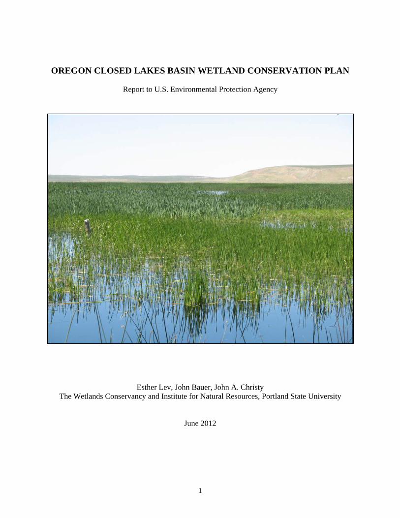
Executive summary This landscape-scale conservation plan focuses on the Guano, Harney, and Warner sub-basins in Harney and Lake Counties. About 493,170 acres of wetlands (excluding streams) occur in the study area, 55% of which are in public ownership. Flood irrigation occurs on about 140,800 acres, and most floodplain areas have extensive networks of irrigation infrastructure. Historically, wetlands expanded and contracted with the region's highly variable precipitation, and both hydrology and vegetation were in a continual state of flux between and within years. Wetland boundaries were ephemeral and moving targets. Today, despite human alterations in flow patterns and timing, wetlands still expand and contract with climatic extremes, and conditions may vary greatly from one year to the next. Large areas mapped as upland in 1876-1880 are now perennially, seasonally, or irregularly flooded because of irrigation regimes. The configuration of historical wetlands may approximate one or more predicted future climate scenarios, where lack of water later in the season may cause some wetlands created by irrigation to revert to drier vegetation types. Climate change projections indicate that runoff will attenuate earlier than it does today, indicating a need for enhanced upstream water storage capacity. In addition to ongoing efforts to improve stream condition in the basin, we recommend (1) restoring natural hydroperiods where feasible, (2) flexibility in irrigation, grazing, and haying schedules to improve synchronization with annual variations in water quantity, duration and timing of runoff, and (3) developing state and transition models and water balance models to better inform management decisions. Acknowledgements Funding for this project was provided by a U.S. Environmental Protection Agency Wetland Program Development Grant, and the Oregon Department of Fish and Wildlife Bird Stamp Grant Program. We thank the following individuals for their help in providing ideas, data, and review of this document: Jess Wenick, Chad Karges, and Carla Burnside (Malheur NWR), Brennan Hauk and Vern Stofleth (Lakeview BLM District). Brad Bales (Oregon Department of Fish and Wildlife), Bob Sallinger (Audubon Society of Portland), Gary Ivey (consulting wildlife biologist), and Bruce Taylor (Oregon Habitat Joint Venture) gave us invaluable insights on the Harney and Warner basins. Cover photo by John Christy.

3
Introduction The Oregon Closed Lakes Basin is part of the Northern Great Basin ecoregion, and contains portions of Crook, Deschutes, Grant, Harney, Klamath, Lake, and Malheur Counties. Containing approximately 6 million acres, the Closed Lakes Basin is comprised of nine major sub-basins or bolsons characterized by interior (endorheic) drainage and arid climates: Abert, Alvord, Goose, Guano, Harney, Summer, Thousand-Virgin, Upper Quinn, and Warner. Vegetation in most of the Basin is dominated by a variety of dry sagebrush, greasewood, juniper, and grassland communities. Despite pervasive aridity, about 500,000 acres of wetlands occur in the Basin. Wetland communities are diverse, and provide important breeding, nesting and migration areas for waterfowl, shorebirds, and marsh and riparian birds that use the Pacific Flyway. Wetlands also provide habitat for endemic fish, amphibians, and a wide variety of invertebrates and native plants (Appendix 1). Additionally, the wetlands store water and capture sediments and nutrients. These ecologically rich habitats often support spectacular concentrations of birds, especially during migration. The most extensive contiguous wetland habitats in the Basin are owned and managed by the U.S. Fish and Wildlife Service (USFWS) and the Oregon Department of Fish and Wildlife (ODFW), and a wide variety of wetland types are protected in a series of federal and private conservation areas (Table 1). The largest areas of wetlands occur on Malheur National Wildlife Refuge (NWR) in the Harney Basin, the Bureau of Land Management's (BLM) Warner Wetlands Area of Critical Environmental Concern (ACEC) in the Warner Basin, BLM's Lake Abert ACEC in the Abert Basin, and on the ODFW's Summer Lake Wildlife Management Area in the Summer Lake Basin. In addition, as of 2011, about 3,738 acres of private land in the Harney Basin have been enrolled in the U.S. Department of Agriculture’s Wetlands Reserve Program, and are subject to permanent conservation easements. The Oregon Closed Lakes Basin covers about 18 percent of Oregon, yet is home to less than one percent of the state’s population. Cities within the Basin are Burns and Hines in northern Harney County, and Lakeview in southern Lake County. The economy of the region is based on ranching, farming, forestry, and recreation. Tourism, hunting, and wildlife viewing contribute an increasing share of the local economy. Because of the short growing season, livestock forage is the primary agricultural product, and most of the hay, grain, and alfalfa produced in the Basin are consumed locally. Need for wetland plan Wetlands in the Oregon Closed Lakes Basin provide livelihoods for farmers and ranchers, and critical habitat for a large diversity of avian, plant, and amphibian species. These wetlands are fragile and threatened by multiple stressors in an arid landscape. Numerous users compete for a limited supply of water. Invasive species, particularly common carp, reed canary grass, and perennial pepperweed, have taken over many of the wetlands and surrounding areas. The complex infrastructure used to manipulate water levels in the basin has deteriorated to the point where it requires increasingly large infusions of money for repair, operation, and maintenance. At the same time, the Closed Lakes Basin may be facing a changing climate that will deliver less

4
water to users in the region. A vision for the future is needed to help decide how to deal with invasive species, competing needs for water, and the future prospect of a changing climate and potentially diminished water supply. The Oregon Closed Lakes Basin is an arid landscape, and the supply of water is a limiting factor for most human activity in the basin, as well as for wetlands and their dependent biota. Almost all agriculture in the Basin requires irrigation (Greater Harney Basin Local Advisory Committee 2007). Precipitation is variable from year to year, and runoff may vary within the same year, resulting in both drought and surplus years, and everything in between. Extensive networks of dikes, ditches, and impoundments divert water for flood irrigation to support farming and livestock production. This water control infrastructure has had a profound effect on wetland habitats, ranging from decimation of some types to proliferation of others, with ancillary effects on soils, vegetation, invertebrates, and fish and wildlife populations. Surplus years may bring longer irrigation seasons and sometimes flooding, while drought years may cause wetland vegetation to die back or be invaded by exotic species. Siltation, nutrient enrichment, and elevated stream temperatures caused by impoundments, removal of riparian vegetation, channel widening, and irrigation return flows have impacted stocks of native cold-water fish. Exotic fish and plants have invaded many wetlands and further compromise their function. Channelization and downcutting have separated streams from their floodplains, reducing natural water storage capacity. These issues are being remedied by private, public, and tribal land managers, with the assistance of local watershed councils and state, federal, and local agencies such as the Natural Resources Conservation Service (NRCS), the Oregon Watershed Enhancement Board (OWEB), the Oregon Department of Environmental Quality (DEQ), the Oregon Department of Agriculture (ODA), the Eastern Oregon Agricultural Research Station, the Harney Soil and Water Conservation District, and the Harney County Watershed Council. Watershed assessments have been completed for a number of sub-basins (Harney County Watershed Council 2000a, 2000b, 2001, 2003, 2010; OWEB 2009). DEQ has established total maximum daily loads for temperature and dissolved oxygen in several of the sub-basins, and adaptive management strategies have been developed for use by private and public land managers to improve local conditions. With assistance from ODA and local soil and water conservation districts, local advisory committees have developed agricultural water quality management plans that establish recommendations for improving water quality (Goose and Summer Lakes Basin Local Advisory Committee 2007, Greater Harney Basin Local Advisory Committee 2007). With agency assistance, some landowners have taken advantage of opportunities for riparian restoration, but within the study area only 3,738 acres are currently enrolled in the NRCS Wetland Reserve Program. The Oregon Conservation Strategy (ODFW 2006) identifies a number of areas in the Basin as Conservation Opportunity Areas. The Oregon Habitat Joint Venture (2005) addresses multiple objectives and strategies related to conservation of wetlands and related habitats. To date, the most comprehensive document assessing conditions and issues in the Oregon Closed Lakes Basin is the draft Comprehensive Conservation Plan (CCP) for the Malheur NWR (USFWS 2011). In addition to an extensive review of the physical, biological, and human environmental setting of the Refuge, the CCP outlines and defines refuge goals and objectives for the next 15 years.

5
Despite all these plans for the Basin, there remains a need for a document that takes a broader view of wetlands and their conservation in the Closed Lakes Basin, to synthesize existing information, and to provide general recommendations that may apply to more than one sub-basin. The Intermountain West Joint Venture's "Prioritizing Wetland Conservation in the Intermountain West" (unpublished draft report) and Ivey and Herziger (2006) provide such an approach, using science-based strategies to identify habitat objectives, needs, and implementation measures required to sustain avian populations and their use of the Pacific Flyway. A landscape-scale wetland conservation plan for the Closed Lakes Basin can help to prioritize on-the-ground actions, define conservation goals and performance standards, and integrate the diverse planning efforts of local, state, and federal agencies, as well as those of NGOs, private landowners, and other private citizens. Study Area An atlas comprised of 29 maps accompanies this report. Maps discussed in the following text are indexed as Map M1, M2, etc. Electronic copies of the report and the atlas will be posted to the Oregon Wetlands Explorer (http://www.oregonexplorer.info/wetlands), the Oregon Lakes Basin Explorer (http://www.oregonexplorer.info/lakes), and The Wetlands Conservancy's web site (www.wetlandsconservancy.org). The Wetlands Conservancy also will post on its web site several animated time-lapse versions of these maps, showing sequences of NVDI and moisture indices throughout the growing season for selected areas in the Closed Lakes Basin. Because the Oregon Closed Lakes Basin covers such a large part of the state, we chose to limit our study area to the Guano, Harney, and Warner sub-basins in Harney and Lake counties (Map M1). While our maps include the southern portions of the Guano and Warner basins that extend into California and Nevada, we excluded these areas from summary statistics. The three sub-basins contain a mix of large private and public wetlands with clearly defined management challenges, and stakeholders who are committed to finding workable solutions to difficult or controversial issues. Malheur NWR is re-evaluating its management practices as part of the CCP process, BLM has similar challenges in managing its Warner Wetlands ACEC, and both ODFW and EPA are interested in exploring a broad-scale approach to wetland conservation. An impressive amount of background research has been compiled for these areas over the years by local, state, and federal agencies, providing a solid basis for evaluating management issues. The other sub-basins of the Closed Lakes Basin (Abert, Goose, Summer, Thousand-Virgin, Upper Quinn) contain many of the same elements and challenges, and our observations are likely applicable to those areas as well. Elevations in the study area range from about 4,100 feet in various valley basins to over 9,000 feet at the summit of Steens Mountain, the highest elevation in the Closed Lakes Basin. Annual precipitation in the basins varies from year to year, ranging from 8-16 inches at low elevations to more than 40 inches on Steens Mountain, with about 30% of the precipitation occurring as winter snow. The upper Silvies River and Silver Creek drainages, Steens Mountain, Hart Mountain, and the Warner Mountains accumulate the deepest snowpacks and are critical sites for seasonal water storage and discharge (Map M2).

6
The only cities in the study area are Burns and Hines, and the rest of the population is scattered throughout the two counties on ranches, farms, and small towns or hamlets like Seneca, Princeton, Frenchglen, Plush, and Adel. Like the Closed Lakes Basin as a whole, the economy of the study area is based on ranching, farming, forestry, and recreation. Most agricultural land occurs on bottomlands, where extensive systems of reservoirs, ditches, and water control structures support flood irrigation on about 140,800 acres (Table 2). BLM manages the largest amount of land in the study area, ranging from 45 to 65% of each sub-basin, while private owners manage the second largest amount at 19-29% (Table 3). Wetlands. About 493,170 acres of wetlands (excluding streams) occur in the study area, including the southern portions of the Warner and Guano sub-basins that extend into California and Nevada (Map M3). Just over half (55%) of these wetlands are in public ownership and are managed by state and federal agencies. The wetlands include extensive marshes, lakes, playas, rivers, perennial streams, and a dense network of intermittent and ephemeral streams. On average, water and barren playa surfaces cover 5 to 14% of the sub-basins (NRCS 2005). Groundwater. Groundwater inputs in the study area are not well documented, but contribute significant amounts of water at certain localities such as Sod House Springs and the OO Spring of the Malheur NWR. Groundwater inputs into Malheur Lake are believed to be significant, but not well understood (Hubbard 1975). Groundwater discharge ranges from fresh to alkaline, the latter in particular at springs on the south shore of Harney Lake. Alkalinity and salinity. The interior drainage pattern of bolsons directs water to the lowest points in the basins, and wetlands in receiving basins tend to be more alkaline or saline than headwaters. Alkalinity and salinity originate from soluble salts in the soil, and these salts become more concentrated with increasing seasonal evaporation and residence time on alkaline or saline soils. Extensive, spatially explicit information on soil and water chemistry in the study area is sparse. For Map M4, we graphically represent salinity and pH data reported by USGS (1975) for Malheur Lake. Salinity data is indirectly measured as conductivity. USGS monitored 9 points within Malheur Lake and four freshwater inputs into the lake, at irregular intervals between February 1972 and July 1973. In general, freshwater inputs into the lake, including groundwater discharge at Sod House Springs, had moderately alkaline pH and low salinity, with conductivity ranging from 124 to 593 micromhos (microsiemens) per cm. Malheur Lake exhibits considerable spatial and temporal variation in pH and salinity. The research period happened to coincide with dropping lake levels, isolating the water body east of Cole Dike. Its dramatic temporal response in salinity as the water evaporated is not surprising. The Guano Basin occurs at the southern end of the study area, and extends into Nevada. The portion of the basin in Oregon contains 1,637,700 acres (Harney County Watershed Council 2010). The basin is bordered on the east by the Steens and Pueblo mountains, on the west by Hart Mountain and Poker Jim Ridge, on the north by the divide at the north end of the Catlow Valley, and on the south by the Nevada state line. About 51,400 acres of wetlands in the basin include marshes, lakes, ponds, playas, and riparian wetlands. Guano Lake, Catlow Marsh (Garrison Lakes), and Slickey Lake are the largest named receiving basins. Important riparian vegetation exists along Home Creek, Threemile Creek, and Skull Creek, perennial streams that

7
flow into the basin from Steens Mountain, and along Guano Slough and Rock Creek that drain Hart Mountain. Several reservoirs constructed on tributary streams around the periphery of Catlow Valley support native fish that periodically repopulate upstream areas as stream flows permit. The Guano Basin has no towns or hamlets, only remote ranches, of which Roaring Springs Ranch is the largest. Ranching and farming are the primary economic pursuits. A modest system of reservoirs, ditches, and water control structures support flood irrigation on about 900 acres (Table 2, Map M14). The Harney Basin contains four sub-basins (Harney-Malheur, Donner und Blitzen, Silver Creek, Silvies) that are sometimes treated separately in planning documents (e.g., Harney County Watershed Council 2000a, 2000b, 2001, 2003). It is bordered on the east by the Stinkingwater and Steens mountains, on the west by the low divide of the Summer Lake Basin, on the north by the Blue Mountains of the Ochoco and Malheur National Forests, and on the south by the Catlow Valley divide. About 110,000 acres of wetlands on the Malheur NWR include marshes, lakes, ponds, playas, and riparian wetlands. Malheur, Mud, and Harney lakes are the primary receiving basins. Important riparian vegetation exists along the upper reaches of Silver Creek and the Silvies River that flow south from the Blue Mountains. The Donner und Blitzen River drains Steens Mountain and is the primary source of water that reaches Malheur Lake. Numerous reservoirs constructed on these streams and their tributaries support native fish that periodically repopulate upstream areas as stream flows permit. Many of the floodplain and lake basin wetlands in the sub-basin are maintained by flood irrigation, and are managed for native hay production and cattle grazing. These practices create habitat for migratory birds, and are used in the spring each year by hundreds of thousands of geese, ducks, cranes, and other waterbirds. These valleys are important habitats for breeding sandhill cranes, waterfowl and shorebirds as well. Three major routes of the Pacific Flyway converge at Malheur Lake. The multitude of wetland habitats on the refuge are used heavily by waterfowl and waterbirds during spring and fall migration. They also provide breeding habitat for a wide variety of species, ranging from ducks, geese, swans and sandhill cranes to shorebirds, colonial waterbirds, and songbirds. Malheur Lake supports some of the highest duck nesting densities in the state, and also a small population of breeding trumpeter swans. The refuge supports the largest numbers of breeding sandhill cranes under any single ownership in the state (Littlefield et al. 1994). Large breeding colonies of white-faced ibises (over 12,000 pairs), egrets, herons, cormorants, American white pelicans, gulls and terns are also present. The wetlands also support high numbers of breeding shorebirds. Harney Lake and Stinking Lake both support breeding snowy plovers, with a peak of over 400 adults counted on the refuge (Hermann et al. 1988). The southern end of the Blitzen Valley supports nesting willow flycatchers. Bobolinks, a state-listed sensitive species, depend on wet meadows for breeding habitat. The largest known bobolink colony west of the Great Plains uses the native hay meadows of the upper Blitzen Valley (Wittenberger 1978). The Refuge also supports raptors, redband trout, and Oregon spotted frogs, as well as a great diversity of other native fauna.

8
The forested portion of the Blue Mountains at the north end of the study area supports timber-related jobs in Seneca and Burns, but sawmills in both towns have closed, as has the rail line from Seneca to Vale. Ranching and farming are the mainstay of the local economy. An extensive system of reservoirs, ditches, and water control structures support flood irrigation on about 97,100 acres (Table 2, Map M14). The Warner Basin occurs at the southern end of the study area, and extends into California and Nevada. The portion of the basin in Oregon contains 898,980 acres (NRCS 2005). It is bordered on the east by Hart Mountain and Poker Jim Ridge, on the west by the Warner Mountains, on the north by the low divide of the Summer Lake Basin, and on the south by the California and Nevada state lines. The string of lakes and playas between Pelican Lake and Bluejoint Lake form about 90,000 acres of lacustrine and palustrine wetlands, most of which occur at Crump and Hart lakes, and in the Warner Wetlands ACEC. Honey Creek, Deep Creek, and Twentymile Creek, perennial streams that flow into the basin from the Warner Mountains, provide most of the water supply for the Warner Basin. Ranching and farming are the mainstay of the local economy, and the only towns are the hamlets of Plush and Adel. A few ranches are located north of Hart Lake and along the west shores of Hart and Crump lakes, but most of the farmland is located at the south end of the basin, where Twentymile Creek and Greaser Reservoir feed an extensive system of ditches and water control structures that support flood irrigation on about 42,800 acres (Table 2, Map M14). The Warner Basin provides habitat for a variety of bird species, particularly colonial waterbirds, including nesting American white pelicans and double-crested cormorants at Pelican Lake, colonies of white-faced ibises, and a variety of gulls, terns, egrets, herons, grebes and other waterbirds. The basin supports substantial populations of breeding ducks and geese, and provides wintering habitat for Canada geese. It is home to four endemic fishes, including the threatened Warner sucker. Many of the basin’s wetlands have been impacted by human development. More than 50,000 acres of former wetlands are now in crops or irrigated hay pastures. At the north end of the valley, BLM manages the Warner Wetlands ACEC, a 52,000-acre wetland complex established primarily for wetland habitat values. About 2,500 acres of BLM-owned wetlands adjacent to Hart Lake were restored in 1988, and are being actively managed to provide habitat for breeding birds. The southern half of the basin has a more varied checkerboard land ownership pattern, particularly around Crump and Pelican lakes. The Twentymile and Honey creek systems provide critical habitat for populations of the threatened Warner sucker, which in spring migrate from the valley to upstream spawning areas. Wetlands background and existing issues Regional hydrologic cycles Annual precipitation strongly influences the amount of water present in the study area. Precipitation is strongly influenced by both the El Niño-Southern Oscillation cycle of 6-18 months (recurring about every 5 years), and the Pacific Decadal Oscillation of 20-30 years

9
(recurring about every 20 years) that affect the entire Pacific Northwest. Stream and lake level gages scattered throughout the study area provide flow data at the most critical points of runoff in the Warner Valley, on Silver Creek, and on the Blitzen and Silvies rivers (Maps M5- M7). Seven stream gages and two lake level gages have sufficient long-term data that are useful for understanding and quantifying hydrologic variations (Map M5). The water level of Crump Lake (Gage 10376000) is monitored by the Oregon Water Resources Department (OWRD 1992), with records in paper format. Elevation data for Malheur Lake, recorded at The Narrows, are maintained by USFWS. Mean daily stream flow data were obtained from USGS, and where available, augmented with records from OWRD, which maintains certain gages after USGS decommissioned them. Stream flow records were analyzed for two key metrics: Center of Timing of flow (CT) and Mean Annual Daily Flow (MADF, a volume measure, typically specified in cubic feet per second). CT, as defined here, is the day in the hydrologic year where half of the annual flow has been exceeded (shown graphically in Map M7B, where the cumulative flow curve crosses the 50% threshold). It is useful for understanding vegetation phenology in wetlands dependent on stream flow, and for describing possible water management options by quantifying variations in timing of water supply and availability. In order to compare hydrologic data between streams, mean annual daily flow data were normalized by dividing a stream’s individual annual flow data by the mean of the MADF (calculated over its period of record). We did not analyze temporal trends in MADF or CT, and thus no detrending of flow data or CT was done. Where appropriate, we used a 5-year moving average window for graphically representing long-term data, in order to minimize the dramatic year-to-year variations that can occur. For the Warner Basin, annual flows of the three gaged streams are well correlated in time (Map M6). The result is not surprising, given the contiguity of the catchments, and similar landscape and precipitation factors. The maximum annual lake level at Crump Lake correlates well with the MADF from Deep Creek (Map M6). Deep Creek was chosen because it is the dominant contributor of water to the basin. The chart’s timeline is a subset of the total period-of-record in order to more clearly illustrate the correlation. Center of Timing for Deep Creek is normally distributed through the hydrologic year, with a median of April 20 (Map M6). MADF is skewed to years of very high water volume. The highest variation in MADF is observed at Honey Creek in the Warner Valley, which has the smallest catchment area of the three streams with gages (table in Map M6). Hydrological behavior is more complex in the Harney Basin than in the Warner Basin. As in the Warner Basin, stream MADF correlate with each other, but large deviations occur, as seen in the Silvies River during the mid-1980s (Map M7A). Distributions of CT and MADF in the Donner und Blitzen and Silvies rivers (Map M7A) exhibit a broader range than those observed in the Warner Basin. The level of Malheur Lake generally tracks well with stream inputs (Map M7B), but it is not as tightly correlated as is observed in the Warner Basin. Groundwater inputs into Malheur Lake are believed to be significant, but not well understood (Hubbard 1975).

10
Dramatic shifts in lake surface area can be observed with slight changes in lake elevation (from Hamilton et al 1986, Map M-7B). Malheur Lake intra-annual elevation fluctuation averages 2.4 feet (data from 1982 – 2002, Map M-7B). Center of Timing for the Silvies River occurs earlier than for the Donner und Blitzen River (hydrograph, Map M7B). CT is correlated between the Silvies and Donner und Blitzen, but with significant variation. No relationship was observed between CT and MADF in any of the gaged streams, including those in the Harney Basin (Map M7B). Although extremes of early CT and low MADF sometimes occur for a stream in the same year (tables in maps M6, M7A), in general, low or high volumes of water have occurred early or late in the hydrologic year. For each decade, about two years in ten have abundant water, two years in ten have drought, and the remaining six years are somewhere in between (Wenick 2009, Stofleth 2011). There is also intra-annual variation in precipitation, when heavy runoff may occur more than once in the same year. Given the extremes in water supply caused by these climatic cycles, wetlands in the study area historically were adapted to expand and contract, and both hydrology and vegetation were in a continual state of flux between and within years. Wetland boundaries were ephemeral and moving targets. Today, despite human alterations in flow patterns and timing, wetlands still expand and contract with climatic extremes, and conditions may vary greatly from one year to the next. LANDSAT imagery inventory (LANDSAT 5 Thematic Mapper, in operation since March 1984) was perused for scenes that best illustrate hydrologic variability and vegetation phenology. LANDSAT is appropriate for broad-scale investigations, but its resolution of 30-meter pixels limits its site-specific usefulness. The wettest and driest periods (1984 and 1992, respectively) show dramatic changes in playa and lake hydration (Maps M8-M10). In 2006, LANDSAT5 recorded excellent regional perspectives on hydrology and vegetation responses. Famously, the extent of the Harney-Mud-Malheur lake system in the Harney Basin has ranged over the last century from completely dry to over 170,000 acres (Harney County Watershed Council 2001). The topography at Malheur Lake is so flat that a one-inch increase in water level floods about 8,500 acres (see graph on Map M7B). Historical wetlands Historical wetland data provide information on the extent and possible functions of wetlands prior to large-scale alteration by white settlement. It can help to identify goals and objectives for conservation and restoration. While the historical record does not provide specific information about historical hydrology, or comprehensive information about historical species composition or wetland function, it can provide generalized information about dominant species, wetland extent, stream channel location, and channel width. This information, combined with data from existing reference sites, can help identify restoration and management techniques, goals, and measures of success. Historical information fills a critical need for an ongoing coordinated wetland conservation and restoration prioritization strategy for the study area. Assessment of historical conditions can help characterize current wetland health and future viability in the basin. Analysis of historical conditions may also shed light on future climate change scenarios by showing the extent of water, wetlands, and streams prior to large-scale alteration for agriculture and wildlife management.

11
For the study area, the earliest information about wetlands are the public land survey notes and plat maps of the General Land Office (GLO), completed primarily between 1873 and 1889. EPA-funded historical mapping in the Harney Basin, using the GLO record as a primary source of information, will be completed in 2012 by Portland State University's Institute for Natural Resources (INR) and The Wetlands Conservancy (TWC). Although the final product is not yet available, GLO plat maps provide snapshots of what conditions might have been like at the time of survey, and examples can be compared with current imagery (Maps M11A, B). GLO plats depicting the area surrounding "Baca" (Boca) Lake on the Malheur NWR (T30S-R31E, T31S-R32E, T31S-R32.5E), surveyed by John Meldrum between 1876 and 1880, show the historical extent of Boca Lake, meanders of the Blitzen River and its tributaries, and floodplain described as "level swamp...subject to occasional overflow during the months of May and June at the annual floods." South of the swamp, in sections 19, 20, 21, 28, 29, 30, and 32, Meldrum mapped another area that was still "subject to occasional overflow," but without wetland symbology, indicating a slightly higher and drier elevation for that area with "soil of 1st rate quality." Vegetation on this site may have been tufted hairgrass-Baltic rush wet meadow. Higher ground in section 30, with a peninsula extending into section 30, presumably was drier. The GLO survey notes may shed more light on what vegetation was present, but it may have supported basin wildrye, creeping wildrye, Nevada bluegrass, greasewood, sagebrush, or rabbitbrush. When compared with NAIP imagery from July 2011, the distinction of swampy lowlands and somewhat higher ground on the floodplain is still evident. It is also evident that today's irrigation infrastructure probably keeps larger quantities of water in place longer in the season than it did historically, which of course is what it was designed to do. However, this has a profound effect on wetland structure and function, and it seems highly likely that more wetlands exist today than historically. Large portions of areas mapped as upland in 1876-1880 are now perennially to seasonally flooded. The configuration of historical wetlands may approximate one or more predicted future climate scenarios, where reduced stream flows later in the season may cause some reversal to drier vegetation types. Existing wetlands Hydrologic modifications. Throughout the study area, hydrology has been modified extensively by impoundments and diversions created for watering livestock and irrigating crops and pasture. (Maps M12-M15). Small impacted wetlands are represented as dots. Wetlands can be enhanced or created by impoundments such as push-up dams. Excavated wetlands typically are created for watering livestock. Stream modifications include channelization, ditches, canals, and aqueducts (Map M14), but do not include bank hardening. In Map M14, the National Hydrology Dataset (NHD) provided most of the information. The National Wetland Inventory (NWI) provided additional information on irrigation canals, some of which was redundant with the NHD, and some that were unique and not represented in the NHD. Even when combined, the NHD and NWI still under-represent the extent of stream channelization and ditching, an observation quickly made apparent when perusing modern aerial photography of the area, especially in “Point of Use” areas. We did not quantify the extent of under-representation. Stock ponds, pervasive throughout arid rangeland in the study area, each intercept a portion of precipitation and runoff. Most agricultural land in the study area occurs on floodplains and lake

12
basins, where extensive networks of reservoirs, dikes, ditches, and water control structures divert water for flood irrigation on about 140,800 acres for farming and livestock production. The extensive water control infrastructure, some of it in place for more than a century, allows users to move water throughout most bottomland areas, depending on seasonal water supply. Federal and state wildlife managers inherited some of these systems when their refuges were established, and they also built or enhanced their own structures as well. Irrigation infrastructure has vastly increased agricultural production in the study area, but it has altered the hydrology of rivers, streams, wetlands, and lakes throughout the study area. The primary change from the historical hydrologic regime is the periodicity and amplitude of flows. The ability to store water and release it later in the season, and to increase or decrease the amount of water delivered to a site, is vastly different from what was probably a single pulse or cluster of pulses that occurred historically during spring runoff. On the positive side, flood irrigation in many ways mimics spring freshets, and performs similar functions such as groundwater recharge, hydrating floodplain vegetation, and cooling of groundwater flows. Flood irrigation is gravity-fed, obviating the need for pump stations and power lines. It also creates important foraging habitat for migratory birds. Oregon water rights can be expressed in volume (acre-feet) or as a flow rate (cubic feet per second). We were unable to locate water right information for the portions of the study area that extend into California and Nevada. Water right points of diversion (Map M13) graphically illustrate the demands on water supplies in the study area. We categorized water rights “point of use” (Map M15) by synthesizing information provided in the Oregon Water Rights GIS database. Dams regulated by OWRD are either 10 feet or more in height, or can store 9.2 or more acre-feet. Not all irrigated areas are wetlands or former wetlands. Point of use data show that the vast majority of water rights are for agriculture, but a few stream reaches—particularly Silver Creek and the Silvies River—have been dedicated to fish and wildlife. Historically, beaver dams kept water tables high, riparian areas hydrated and well vegetated, served as sediment traps, and prevented streams from downcutting (Kindschy 1985, McComb et al. 1990, Pollock et al. 1995). Extensive trapping of beaver by 19th-Century fur brigades, routine removal of both beaver and riparian willows on the Malheur NWR between 1936 and 1973, and more than a century of heavy livestock use of unprotected riparian areas tended to reverse the beneficial legacy of beavers (Langston 2003). National Wetland Inventory (NWI) mapping indicates the presence of beavers in the Silvies River drainage, on Hart Mountain, and in the Warner Mountains (Map M12), but their recovering numbers are vastly underrepresented by NWI. For example, beaver are well established on Steens Mountain, but beaver-influenced wetlands are not mapped by NWI. Aside from the fact that beaver impoundments vary spatially over time, most NWI mapping done in the area, with the exception of recent work done on the Malheur NWR, used aerial imagery from the early 1980s when beavers were somewhat less abundant. Existing wetland habitats. The Oregon Closed Lakes Basin contains a multitude of freshwater and alkaline wetlands, playas, perennial rivers, and perennial, intermittent, and ephemeral streams (Maps M16, M17). Classification of playas and stream types sometimes differ between NHD and NWI. The unpredictable and highly variable water supply creates wetlands with ephemeral boundaries that are in a continual state of hydrologic flux between and within years.

13
This variability creates seasonal and annual differences in plant community composition and wetland size. Movement of water during the spring runoff may no longer be as rapid as it was historically because water control structures store it upstream and release more uniform amounts over a longer period of time. However, there is still a perceptible seasonal pulse as water moves downstream toward the receiving basin. LANDSAT imagery shows the phenology of water and vegetation for a small portion of the Blitzen River area through the spring, summer, and fall of 2006—a year in which most of the growing-season imagery was cloud-free (Map M18). Based on Cowardin et al. (1979), wetlands in the Oregon Closed Lakes Basin can be sorted into Palustrine, Lacustrine, and Riverine systems that are defined below. Vegetation types in the Basin are largely determined by hydroperiod, or how long water stays on the site, and by soil and water chemistry. Cowardin hydroperiods applicable to the Closed Lakes Basin include (a) permanently flooded—surface water present all year, (b) semipermanently flooded—surface water present most years, (c) seasonally flooded—surface water present for extended periods during part of the growing season, but absent by the end of the season, (d) saturated—soil perennially wet, but surface water seldom present, (e) intermittently flooded—surface water usually absent, but sometimes present in wet years, without any seasonal pattern, and (f) artificially flooded—amount and duration of flooding controlled by infrastructure. In addition to hydroperiod, wetland communities are strongly influenced by alkaline and saline soils, which determine what plant species can survive at a given site. 1. Palustrine wetlands are smaller than 20 acres, and range from stands of herbaceous or woody vegetation with no surface water, to habitats flooded up to 6.6 feet deep. a. Palustrine aquatic bed wetlands are permanently to semipermanently flooded, and contain rooted or unrooted plants that float on the surface of the water or form submerged beds. Important aquatic bed communities in the Closed Lakes Basin include sago pondweed (Potamogeton pectinatus), coontail (Ceratophyllum demersum), pondweeds (Zannichellia palustris, Potamogeton spp.), white water buttercup (Ranunculus aquatilis), widgeongrass (Ruppia maritima), and common bladderwort (Utricularia macrorhiza). Sago pondweed is a keystone species in Malheur Lake, and a critical food to many waterfowl. Aquatic beds and emergent plant communities such as bulrushes or cattails often occur intermixed and form mosaics of different vegetation types. Water depths range from two to six feet deep. Colonial nesting waterbirds rely on these stable water conditions and their diverse food sources. b. Palustrine emergent wetlands are characterized by rooted, rigid-stemmed plants that protrude above the surface of the water. Because of the wide range of hydroperiods that occur in the Closed Lakes Basin, palustrine emergent wetlands are the most widespread and variable wetland type in the study area. They are extremely important for livestock forage and nesting habitat for numerous species of birds. All hydroperiods are represented, ranging from permanently flooded to intermittently or artificially flooded, and flood irrigation maintains many of these stands. Important freshwater marsh communities include hardstem bulrush (Schoenoplectus acutus), cattails (Typha latifolia, Typha angustifolia), broadfruit bur-reed (Sparganium eurycarpum), and longroot smartweed (Persicaria amphibia). Water depths in marshes typically range from 2-3 inches to 2-3 feet. Perennially to seasonally wet meadows include tufted hairgrass (Deschampsia caespitosa), meadow barley (Hordeum brachyantherum), Baltic and Nevada rush (Juncus

14
balticus, Juncus nevadensis), and various sedges (Carex spp.), as well as a large array of flowering plants. Spring migrants make extensive use of seasonally flooded wetlands, while fall use is dependent on cool temperatures (lower evaporation rates) and wet weather patterns. Saline or alkaline sites with seasonal or intermittent hydrology support saltgrass (Distichlis spicata), three-square bulrush (Schoenoplectus pungens, Schoenoplectus americanus), creeping wildrye (Leymus triticoides), alkali grass (Puccinella spp.), alkali cordgrass (Spartina gracilis), and seaside arrow grass (Triglochin maritima). This habitat is often rich in submerged aquatic plant growth that supports immense and diverse invertebrate communities. Forage fish, primarily tui chub, are sometimes present. These sites vary in productivity, capability and wildlife use depending on depth and permanency of water levels. In some areas, collection of irrigation runoff and the inability to dewater these sites create almost permanently flooded conditions. This habitat type provides foraging sites for a diverse array of wetland dependent and wetland obligate wildlife species, both migrants and residents. Many species will use these wetlands as breeding, brood rearing, and molting habitat. Cattails and invasive species like reed canarygrass (Phalaris arundinacea), meadow foxtail (Alopecurus pratensis), Kentucky bluegrass (Poa pratensis), and perennial pepperweed (Lepidium latifolium) expand and contract in response to low and receding water levels that allow seedling development on exposed mudflats, or extension of rhizomes from existing plants. Associated open water areas also expand and contract. In years with less open water and dense tall vegetation, habitat value and use by nesting waterbirds decrease. These sites vary in productivity, capability, and wildlife use depending on depth, timing and rate of receding water levels, as well as amounts of vegetation present. Extensive mudflats with little or no vegetation can sometimes occur in this habitat. Mudflats can be intermittently flooded as levels fluctuate due to hydrologic manipulations or wind. Cycles of irrigation and drying produce diverse and abundant populations of aquatic and terrestrial invertebrates, providing a wide variety of food for waterbirds. Dabbling ducks, shorebirds and sandhill cranes (Grus canadensis) forage in this habitat extensively. Idle fields contain abundant residual vegetation that provides dense nesting cover for many species of dabbling ducks and other ground nesting birds. In addition to flood irrigation, winter precipitation often creates flooded and saturated conditions lasting into early spring, providing foraging sites for migrants and returning resident breeding species. c. Palustrine scrub-shrub wetlands are dominated by woody shrubs and trees less than 20 feet tall. Freshwater scrub-shrub communities in the Closed Lakes Basin are mostly limited to riparian stands of willows (Salix spp.), water birch (Betula occidentalis), and red-osier dogwood (Cornus sericea). Saline or alkaline sites with intermittent hydroperiod, particularly playas, support more specialized shrub communities dominated by silver sagebrush (Artemisia cana), greasewood (Sarcobatus vermiculatus), and iodine bush (Allenrolfea occidentalis), with basin wildrye (Leymus cinereus) and Nevada bluegrass (Poa secunda). d. Palustrine forested wetlands are dominated by trees over 20 feet tall. Forested wetlands are scarce in the Closed Lakes Basin, and restricted to riparian stands in foothills. The primary trees are black cottonwood (Populus trichocarpa) and wetter expressions of quaking aspen (Populus tremuloides) communities.

15
2. Lacustrine wetlands are larger than 20 acres, and deeper than 6.6 feet. These wetlands include the region's larger water bodies such as Harney, Hart, Malheur, and Crump lakes. Their bottoms are composed of unconsolidated mud and they are usually too deep to support vegetation. During dry cycles, many of these lakes become playas. High-quality examples of lacustrine wetlands are protected at Warner Wetlands ACEC, Harney Lake Research Natural Area (RNA), and Stinking Lake RNA. a. Lacustrine aquatic bed wetlands are similar to palustrine aquatic bed wetlands, and are usually restricted to shallower areas around the perimeters of lakes. These habitats are significant waterbird foraging areas because of the diversity of vegetation and invertebrates that occur here. Isolation, open water, and shallow depth provide secure and disturbance-free roosting and loafing sites for a wide variety of waterbirds. In dry years, lake waters may recede to low levels, exposing mudflats that may dry out late in the season. b. Playas are classified as intermittently flooded lacustrine wetlands. They are characterized by flat surfaces with extensive deposits of salt or alkali brought to the surface by evaporation of soil moisture. Vegetation is usually nonexistent to sparse, but occasionally can be prolific. Some playas are surrounded by alkali-tolerant scrub-shrub vegetation (silver sagebrush, greasewood, iodine bush, etc. see # 1c above). Macroinvertebrate may be abundant. Western snowy plovers (Charadrius alexandrinus) make extensive use of playas to nest and forage. Other waterbirds will roost or loaf here, taking advantage of the lack of vegetation and security from ground-based predators. High-quality examples of playas are protected at Warner Wetlands ACEC, Harney Lake RNA, and Stinking Lake RNA. 3. Riverine wetlands are springs, creeks, and rivers, and are restricted to the area between the channel banks. Emergent communities that may occur between the banks are considered palustrine. Most riverine wetlands are unvegetated, but may contain aquatic bed communities. This habitat is important to Oregon spotted frogs, mergansers, belted kingfishers, river otters, and mink. Existing riparian habitats Most riparian plant associations in the northern Great Basin are considered by the Oregon Biodiversity Information Center (ORBIC) to be at risk. These associations are usually ranked G1 or G2, and few good-quality examples remain. Almost universally, riparian habitats in the study area have been degraded by more than a century of livestock impacts and removal of both beavers and willows. Cover of native cottonwood (Populus trichocarpa), willows (Salix spp.), water birch (Betula occidentalis), sedges (Carex spp.), and grasses has been severely reduced by cows seeking shade and forage. Concentration of livestock in riparian areas reduces recruitment of woody vegetation, compacts and erodes stream terraces and banks, promotes establishment of invasive plant species, and pollutes water. Impacts to streams include elevated water temperatures and sedimentation. Trampling of stream banks and removal of beaver and willows from streams has caused stream incision, lowering of water tables, reduced floodplain water storage capacity, and reduced or eliminated riparian

16
vegetation. A few high-quality examples of riparian habitat are protected at Pueblo Foothills RNA/ACEC, Rooster Comb RNA, Silver Creek RNA, and Sink Lakes-Guano Creek RNA (Table 1; Housley 2004). Existing Fish and Wildlife Use The concentration of wetlands in the study area is a critical staging area for waterfowl that use the Pacific Flyway. Habitats are used by a wide variety of birds, and provide food, rest, and cover for nesting and migration. Individual birds may visit and use most of the large wetlands in the area at some stage of their life cycle. The Audubon Society of Portland (2012) has identified five Important Bird Areas (IBAs) in the study area (Malheur NWR, Hart Mountain National Antelope Refuge, Steens Mountain, Warner Basin, Silvies River floodplain). The Warner Basin and the Harney Basin also have been identified as focal areas by the Intermountain West Joint Venture (2012). The condition of wintering and breeding habitats influences populations to a much greater extent than migration staging areas. Habitats in those areas have undergone significant change and continue to be altered and/or enhanced. Throughout the Pacific Flyway, weather patterns and hydrologic management affect the distribution of waterbird populations. These factors influence timing and patterns of migration, as well as use of wetlands in the study area. At least 40 percent of Pacific Flyway snow geese and Ross’ geese stage at Summer Lake and the Harney Basin in spring. Larger wetland complexes in the area provide migrational staging areas for tundra swans, Canada geese, Pacific greater white-fronted geese (including tule geese), lesser snow geese (including Russia’s Wrangel Island and Western Canadian Arctic snow geese), Ross' geese, northern pintails, American wigeon, green-winged teal, mallards, gadwalls, canvasbacks, redheads and other diving ducks. Larger wetland complexes provide habitat for tens of thousands of breeding waterfowl, including large numbers of Canada geese, cinnamon teal, redheads, gadwall, and mallards; and significant populations of other ducks, including northern pintails and canvasbacks. A small population of trumpeter swans also breed in the area. The area’s waterbird population is even more diverse, supporting some of the largest breeding colonies in Oregon, including the only breeding area in Oregon for Franklin’s gulls (Littlefield and Thompson 1981). Other breeding colonial nesting birds include American white pelican, double crested cormorant, great blue heron great egret, snowy egret, cattle egret, black-crowned night heron, white-faced ibis, Caspian tern, ring-billed gull and California gull. Greater sandhill cranes nest throughout the area with many lesser sandhill cranes staging in irrigated private hay meadows during spring migration. Other breeding waterbirds include grebes (western, Clark’s, eared, horned, pied-billed), bitterns (American, least), rails (sora, Virginia, yellow), American coot, and terns (Forster’s, Caspian, black). Numerous shorebird species use habitat in the Summer Lake, Lake Abert, and Harney, basins. Other breeding shorebirds include killdeer, blacknecked stilt, American avocet, willet, spotted sandpiper, long-billed curlew, common snipe, and Wilson’s phalarope. Species staging during spring and fall migration include semipalmated plover, greater and lesser yellowlegs, western and least sandpipers, long-billed dowitcher, and red-necked phalarope (Ivey 2000). Fish are prominent in the study area because of the high level of endemic species such as the Catlow tui chub, Catlow redband trout, Malheur mottled sculpin, Warner redband trout, Warner

17
sucker, and Warner tui chub, all of which are federally and state-listed species of concern (Table 4). Over the last 20 years, the presence of these species has focused public attention on water quality in the region's streams, springs, and lakes. It has also forced local and state agencies to formulate watershed assessments and agricultural water quality management area plans that have drawn together diverse players and compiled a wealth of local information (Goose and Summer Lakes Basin Local Advisory Committee 2007, Greater Harney Basin Local Advisory Committee 2007, Harney County Watershed Council 2000a, 2000b, 2001, 2003, 2006, 2010). In addition to native species, 19 species of exotic or transplanted native game fish were introduced by ODFW and fishermen between the 1930s and the 1970s (Hayes 1980). Lahontan cutthroat trout, native to the Great Basin, has been introduced in the study area. Similarly, California roach is thought to have been introduced in the Warner Basin. Common carp (Cyprinus carpio) is thought to have been introduced to the Silvies River in the early 1920s, and is currently the focus of renewed eradication efforts, as has been done periodically since1955 (Duebbert 1969, Marshall 2008). Carp have consumed most of the invertebrates and sago pondweed (a keystone food plant for waterfowl) in Malheur Lake, reducing duck populations from hundreds of thousands to about 20,000. Mammals occurrring in Closed Basin wetlands include beaver (Castor canadensis), bobcat (Lynx rufus), mink (Mustela vison), muskrat (Ondatra zibethicus), and raccoon (Procyon lotor). They provide habitat benefits through vegetation clipping and den and dam construction. Other species include coyote (Canis latrans), striped skunk (Mephitis mephitis), long-tailed weasel (Mustela frenata), Nuttall’s cottontail (Sylvilagus nuttallii), voles and mice, black-tailed jackrabbits (Lepus californicus), pocket gophers (Thomomys townsendii), kangaroo rats (Dipodomys ordii), porcupine (Erithizon dorsatum), chipmunks (Eutamias spp), woodrats (Neotoma spp.), feral cats (Felis domesticus) and cougar (Felis concolor). A variety of bat species also feed on wetland invertebrates. Native species of snakes, lizards and frogs are plentiful in Closed Lakes Basin wetlands. These include long-toed salamander (Ambystoma macrodactylum), great basin spadefoot (Spea intermontana), pacific tree frog (Pseudacris regilla), western toad (Anaxyrus boreas), Columbia spotted frog (Rana luteiventris), and bullfrog (Rana catesbeiana). The Columbia spotted frog (Rana luteiventris) is a candidate for listing under the Endangered Species Act. Destruction, fragmentation and degradation of wetlands, drought, water diversions, loss of beavers, and the introduction of non-native predators such as bullfrogs, bass and other predatory freshwater fish, are the greatest known threats to Columbia spotted frogs in the Closed Lakes Basin. Spotted frogs usually occur in or near perennial bodies of water that include areas of shallow water and emergent vegetation. They use the floating vegetation as basking platforms, and as cover to hide from predators. Standing water, flooded meadows, and willows provide breeding, foraging, and overwintering habitat. Most spotted frogs hibernate in spring-fed ponds with willows (USFWS 2010).
18
Wetland issues of conservation concern Changes in hydroperiod, water management, grazing, and establishment of invasive species have negatively impacted wetland health and quality.
Riparian and wet meadow communities are the rarest vegetation types in the Closed Lakes Basin because of the cumulative impacts of more than a century of agriculture, heavy use by livestock, and water manipulation. Wet meadows have been negatively impacted to such a degree by grazing and flood irrigation that their original composition is not well understood, and undisturbed stands suitable for reference sites may no longer exist.
Rare plants, fish, and wildlife (federally-listed, state-listed, and species listed as G1, G2,
S1 and S2 by ORBIC) should be included in any planning and site prep work.
The hydroperiod created by pervasive water management likely does not match historical conditions. More wetlands exist today than in 1880, as intended by those who built water management infrastructure. This has increased the productivity of wildlife habitat and livestock forage, but effects on certain plant communities are unknown. The numerous impoundments behind cross dikes have created open water habitat for waterfowl, but during the summer these water bodies get too hot for cold-water fish, and streams get listed as temperature and water-quality limited. At the same time, emergent marsh vegetation is encroaching on the impoundments, causing concern about loss of waterfowl habitat. Marsh vegetation is also encroaching on hayfields and reducing opportunities for cutting hay.
Invasive carp and exotic plants are of particular concern within the Closed Lakes Basin.
As noted previously, they disrupt native communities and ecological processes, diminish populations of at-risk native species, and threaten the economic productivity of resource lands.
Climate change and projected effects on hydrology For this analysis, we used the results of a recently published model by the U.S. Forest Service's Rocky Mountain Research Station (RMRS 2011). The study developed a regional hydrologic model with stream flow metric estimates coupled directly to stream hydrology (in this case, the NHD 100K dataset). After calibrating recent historic stream flow data (1970-1999) to the hydrologic model, RMRS then incorporated precipitation and temperature predictions from several climate change General Circulation Models (GCM), and projected changes for several stream metrics. Map M19 shows the variations in the model's Center of Timing estimates, calibrated to recent conditions. (For cartographic clarity, the NHD stream set was filtered to show streams with mean annual daily flow rates greater than 0.5 cfs). The model's estimates show that the Silvies River supplies water to Malheur Lake earlier in the hydrologic year compared to the Donner und Blitzen, which agrees with the gage data shown in Map M7B.

19
To generate estimates for two key stream hydrology metrics for 2040, we used the RMRS’ ensemble model, which combined predictions from 10 GCM. Estimated change in CT in 2040 (Map M20) shows either no shift or a shift to earlier in the year. Shifts of up to 30 days are predicted for McCoy Creek and smaller streams feeding Deep Creek. Likewise, changes in water volume are predicted to be negligible or negative, up to -19% (Maps M21). High-elevation streams on Steens Mountain are most impacted, but their reduced flow is moderated by contributions from lower elevation streams as the Donner und Blitzen River enters the Malheur NWR. Recommendations Historically, wetland habitats of the Oregon Closed Lakes Basin were created and maintained by a suite of ecological processes, most importantly by seasonal hydrology. Management of water (diversion, flood irrigation, and drawdown) and vegetation (grazing, mowing, controlled burning, plowing, discing) are tools that have been used to maintain ecological processes needed to sustain these habitats. Because different wildlife species use a wide variety of habitats, benefits from these management techniques are varied. Not all species or guilds (groups of species with similar habitat requirements) will see benefits at all times. These management practices also require ongoing investments of time and money to maintain or replace water control structures, and to maintain pastures for haying or farming. Recent shifts in water level, timing, and duration have added new dynamics to an already altered and ephemeral system. Some of the emergent wetlands that are maintained by surface irrigation and managed for hay production or grazing also provide high quality habitat for migratory waterfowl, cranes and other waterbirds in the spring. In wet years, meadows and floodplains can produce significantly higher numbers of birds than in drier years. Draining wet meadows in June to provide access for mowing or haying equipment limits available brooding areas for newly hatched waterfowl. Identifying the seasonal requirements of migrating, breeding, nesting, and brooding wildlife species, and improving water delivery regimes to enhance efficiency and flexibility of irrigation, will improve outcomes for conservation of habitats and fish and wildlife species. This should include adequate quality, quantity, and timing of water delivery for existing wetlands in response to seasonal climate fluctuations. 1. Restore natural hydroperiod. In the face of declining public funds and private capital, increasing fuel costs, and the uncertainty of future water supplies caused by climate change, restoring a more natural hydroperiod to some sites may be feasible in some parts of the study area. This approach, while not universally acceptable, may be useful in hard-to-manage areas, or in areas where returns on investments do not justify ongoing inputs of resources. In these cases, abandonment of flood irrigation and investment in habitat restoration may be a more sustainable use of the site. The end result will probably be fewer permanent wetlands and more seasonal wetlands. It will likely reduce the overall area of irrigated wetlands, and increase the area of greasewood, saltgrass, or sagebrush communities. Social acceptance of diminished agricultural outputs may improve if these sites are seen as long-term enhancements to landscape function, including the potential availability of more water for downstream use.

20
2. Reduce temperature and sediment loads in streams. Restoration of woody riparian habitat would help improve water quality and enhance conditions for land birds and native fishes. Channel restoration, coupled with replanting of woody riparian vegetation and reintroduction of beavers, will help reduce erosion and water temperatures, and counter the negative effects of stream incision. Fencing of some riparian areas has enhanced restoration projects by excluding livestock from replanted areas, or from degraded areas left to recover riparian vegetation on their own. 3. Be adaptable. Rigid grazing and haying schedules do not always synchronize well with annual variations in water quantity, duration and timing of runoff. While time-certain dates provide certainty for lessees, over-reliance on the amount and timing of runoff can have major negative impacts to breeding and nesting bird species. Flexibility in annual schedules that match the actual water conditions could alleviate some of these pressures, similar to how private landowners must manage their own lands in synchrony with weather or flooding patterns. Adaptive management provides both public and private managers the ability to assess the effectiveness of management strategies, and revise plans as needed to improve outcomes. 4. Develop state and transition models. Development of baseline data, state and transition models, and long-term monitoring of reference sites will help identify the composition of wetland communities and the dynamic environmental factors that affect them. State and transition models help managers understand how dynamic habitats may respond to changes in land use or management practices, and external drivers such as climate. Models also enable managers to identify desired future conditions and adaptive management practices. Again, flexibility is a key attribute, because it enables managers to modify treatments as needed. Once workable models are established, findings should be shared with other land management agencies, private landowners, the High Desert Partnership, and other non-governmental organizations (NGOs) that work in the Closed Lakes Basin. On-the-ground case studies and results of models will also assist NRCS in setting restoration goals and desired future conditions for Wetland Reserve Program and Conservation Restoration Enhancement Program projects. 5. Develop a water balance model. Both private and public managers can improve their land stewardship by knowing how water moves across their properties. A thorough understanding of existing water control infrastructure, coupled with modeling of water quantity and timing at both high and low flows, will help improve planning and adaptive management. 6. Protect and enhance rare wetland types. Riparian and wet meadows are the most heavily impacted wetland types in the study area. Woody riparian communities will benefit from restoration actions, and the downstream benefits of enhanced groundwater storage, lowered stream temperatures, and diminished sediment loads make them the most important wetlands in the landscape. Wet meadows support a large diversity of plants and animals, and weed control is the primary management tool needed to maintain healthy communities. 7. Control Invasive Plants. Invasions of exotic weeds are a problem in Closed Lakes Basin wetlands. These invasive species can often replace large areas of native plant communities, and in turn negatively impact native flora and fauna. Reed canary grass forms dense monotypic stands that essentially exclude wildlife and limit biological diversity. Perennial pepperweed

21
grows in seasonal wetlands and associated uplands and can also outcompete native plant communities. Develop partnerships to address problem weeds. Changing the timing and duration of irrigation regimes may offer some tools for successful management of invasive species. 8. Control Invasive Common Carp. Exotic common carp have decimated the productivity of beneficial aquatic plants, invertebrates, and waterfowl in Malheur Lake and its tributaries. After nearly 50 years of ineffective carp control, a partnership of agencies, NGOs, and private landowners are developing and implementing a basin-wide, long-term carp control plan (Beck et al. 2011). 9. Collect data on the impact of recent refuge management practices on habitat health. Haying and grazing have been used to manage litter accumulation in meadows for nesting, and to provide early and late foraging habitat for a variety of species. However, these practices have not been effective at managing encroachment by emergent wetland plants or invasive plants such as reed canary grass, common reed (Phragmites australis), or perennial pepperweed. In the past, many of the treatment strategies and timing of applications have been guided by wildlife production schedules and not by ecological parameters for influencing plant community succession. Haying and grazing do not appear to be having the desired impact on encroaching or invasive plant species because these treatments are usually implemented at the end of the growing season, when most plants become dormant. 10. Reintroduce beavers to the system. Restoration of beavers and their dams could potentially increase water storage capacity, stream baseflows, and groundwater recharge. These changes will in turn improve the quality of riparian and wetland habitat. USFS and a variety of partners have developed and are beginning to implement a Beaver Management strategy for the Malheur National Forest and the Closed Lakes Basin (USFS 2007). Reintroduction of beaver is also being implemented elsewhere in the arid western United States (e.g., Buckley et al. 2011). 11. Prepare for climate change. Because climate change will likely reduce the availability of water later in the season, storage of water upstream will become more important to maintain downstream flows. More artificial impoundments may be needed, but these are subject to summer heating and contribute to elevated stream temperatures. Reconnecting channelized rivers and streams to floodplains could be a useful strategy to rehydrate riparian zones, raise the water table, and increase the water storage capacity of floodplains, without the deleterious heating effects of impoundments. Develop locations and strategies for storing and releasing water during periods of high water, and identify the best places to move and store water during drought cycles that will provide critical seasonal habitat features required by wildlife. 12. Ongoing conversation and strategizing. Managers and landowners throughout the Closed Lakes Basin should continue conversations and brainstorming on how to meet seasonal water requirements for fish and wildlife during dynamic water years, and to plan for potential changes in water salinity caused by climate change.

22
REFERENCES Audubon Society of Portland. 2012. Important Bird Areas Program: a global currency for bird
conservation. http://audubonportland.org/local-birding/iba/iba-map
Beck, L., A. Daniel & S. Hurn. 2011. Improving the aquatic health of Malheur National Wildlife
Refuge. Appendix S in: Malheur National Wildlife Refuge, Draft Comprehensive Conservation Plan and Environmental Impact Statement. 27 pp.
BLM. 2005. Andrews Management Unit Record of Decision and Resource Management Plan.
BLM/OR/WA/PL-05/027-1792. Andrews/Steens Resource Management Plan, Burns District Office. 106 pp.
BLM. 2010. Burns District Planning Update, fiscal year 2010. USDI Bureau of Land
Management, Burns, Oregon. 76 pp. Buckley, M., T. Souhlas, E. Niemi, E. Warren & S. Reich. 2011. The economic value of beaver
ecosystem services, Escalante River Basin, Utah. EcoNorthwest, Portland, Oregon. 64 pp Cowardin, L.M., V. Carter, F.C. Golet & E.T. LaRoe. 1979. Classification of wetlands and
deepwater habitats of the United States. USDI Fish & Wildlife Service, Biological Services Program. FWS/OBS-79/31. 103 pp.
http://oregonexplorer.info/data_files/OE_topic/wetlands/documents/ClassificationWetlandsDeepwaterHabitatsUS.pdf
Duebbert, H.F. 1969. The ecology of Malheur Lake and Management Implications. U.S. Fish
and Wildlife Service Refuge Leaflet 412. 24 pp. Goose and Summer Lakes Basin Local Advisory Committee. 2007. Goose and Summer Lakes
Basin agricultural water quality management area plan. Second biennial revision. Harney Soil and Water Conservation District, Hines, Oregon. 34 pp. [Includes Warner Basin].
http://www.oregon.gov/ODA/NRD/docs/pdf/plans/goose_summer_plan_2007.pdf Greater Harney Basin Local Advisory Committee. 2007. Greater Harney Basin agricultural water
quality management area plan. Second biennial revision. Harney Soil and Water Conservation District, Hines, Oregon. 50 pp.
http://www.oregon.gov/ODA/NRD/docs/pdf/plans/harney_plan_2007.pdf Hamilton, D.B., G.T. Auble, R.A. Ellison & J.E. Roelle. 1986. Effects of flood control
alternatives on the hydrology, vegetation, and wildlife resources of the Malheur-Harney Lakes Basin. U.S. Fish and Wildlife Service, National Ecology Center, Fort Collins, CO. NEC-86/20. 85 pp.

23
Harney County Watershed Council. 2000a. Silver Creek subbasin assessment. Burns, Oregon. 23 pp.
Harney County Watershed Council. 2000b. Silvies sub-basin assessment. Burns, Oregon. 55 pp. Harney County Watershed Council. 2001. Harney-Malheur Lakes sub-basin assessment. Burns,
Oregon. 88 pp. Harney County Watershed Council. 2003. Donner und Blitzen sub-basin watershed assessment.
Burns, Oregon. 149 pp. Harney County Watershed Council. 2010. Guano and Thousand-Virgin Sub-basins watershed
assessment. Burns, Oregon. 102 pp + appendices. Hayes, J.P. 1980. Fish of Warner Valley. Pp. 120-139 in: C. Gilman et al., Final report,
Analysis of the aquatic habitats of Warner Valley, with relation to land use patterns. Report to National Science Foundation. Department of Fisheries and Wildlife, Oregon State University, Corvallis. 175 pp.
Herman, S. G., J. B. Bulger and J. B. Buchanan. 1988. The snowy plover in southeastern Oregon
and western Nevada. Journal of Field Ornithology 59:13-21. Housley, L.A. 2004. Guano Creek/Sink Lakes. Kalmiopsis 11: 10-16. Hubbard, L.L. 1975. Hydrology of Malheur Lake, Harney County, southeastern Oregon. USGS
Water Resources Division, Portland, Oregon. Water Resources Investigation Reports WRIR 21-75, 46 pp.
Intermountain West Joint Venture. 2012. Focal Area Maps, Shorebird Science Team. Accessed
June 2012. http://iwjv.org/68/focal-area-maps.html Ivey, G. 2000. Joint Venture Implementation Plans for Eastern Oregon: Oregon Closed Basin.
Oregon Wetlands Joint Venture, Lake Oswego, OR. 25 pp. http://www.ohjv.org/pdfs/closed_basin_plan.pdf Ivey, G.L. & C.P. Herziger. 2006. Intermountain West Waterbird Conservation Plan, Version
1.2. U.S. Fish and Wildlife Service Pacific Region, Portland, OR. 205 pp. http://www.waterbirdconservation.org/pdfs/regional/maintextv12nocover.pdf Kindschy, R.R. 1985. Response of red willow to beaver use in southeastern Oregon. Journal of
Wildlife Management 49: 26-289. Langston, N. 2003. Where Land and Water Meet: a Western Landscape Transformed. University
of Washington Press, Seattle. 230 pp.

24
Lincoln, B. 1996. [BLM] Research Natural Areas in Washington and Oregon. BLM/OR/WA/PL-95/051+1792. USDI Bureau of Land Management, Portland, Oregon. 73 pp.
Littlefield, C.D., M.A. Stern & R.W. Schlorff. 1994. Summer distribution, status, and trends of
greater sandhill crane populations in Oregon and California. Northwestern Naturalist 75: 1-10.
Marshall, D.B. 2008. Memoirs of a wildlife biologist. Audubon Society of Portland. 221 pp. McComb, W.C., J.R. Sedell & T.D. Buchholz. 1990. Dam-site selection by beavers in an eastern
Oregon basin. Great Basin Naturalist 50: 273-281. NRCS. 2005. 8-Digit Hydrologic Unit profiles for Harney/Malheur Lakes, Donner und Blitzen, ,
Guano, and Warner Lakes watersheds. Oregon Lakes Basin Explorer. Natural Resources Digital Library, Oregon State University Libraries. Accessed November 2011. http://oregonexplorer.info/lakes
ODFW. 2006. Oregon Conservation Strategy. Oregon Department of Fish and Wildlife, Salem, Oregon. http://www.dfw.state.or.us/conservationstrategy
Oregon Habitat Joint Venture. 2005. Coordinated Implementation Plan for Bird Conservation in Eastern Oregon. Lake Oswego, OR. 43 pp.
OWEB. 2009. Lake County Watershed Council Area Watershed Health Indicators. Oregon Watershed Enhancement Board, Salem, Oregon. 54 pp. http://www.oregonwatersheds.net/south/files/lake_wc_watershed_indicators_final_6-25-2009.pdf
OWRD. 1992. Compilation of Surface Water Records for Oregon, Silver Lake, Warner Lake, and Goose Lake Basins, 1979-1991. Oregon Water Resources Department.
Pollock, M.M., R.J. Naiman, H.E.Erickson, C.A. Johnston, J. Pastor & G. Pinay. 1995. Beaver as
engineers: influences on biotic and abiotic characteristics of drainage basins. Pp. 117-126 in: C.G. Jones & J.H. Lawton (eds.). Linking Species and Ecosystems. Chapman & Hall, New York. 387 pp.
RMRS. 2011. Western US Stream Flow Metric Dataset (GIS Dataset), downloaded Sep 30,
2011, http://www.fs.fed.us/rm/boise/AWAE/projects/modeled_stream_flow_metrics.shtml. Formally described in: Wenger, S.J., C.H. Luce, A.F. Hamlet, D.J. Isaak & H.M. Neville. 2010. Macroscale hydrologic modeling of ecologically relevant flow metrics. Water Resources Research. 46: W09513. doi:10.1029/2009WR008839.
Stofleth, V. 2011. Warner Wetlands ACEC. Personal communication with Lev, Bauer, and
Christy. October 2011.

25
USDA. 2000. 1997 USDA National Resources Inventory (NRI) database, revised 2000. Accessed November 2011. http://www.nrcs.usda.gov/wps/portal/nrcs/main/national/technical/nra/nri
USFS. 2007. Interagency Coordination Agreement, beaver management strategy, Malheur
National Forest and the Keystone Project. 14 pp. USDA Forest Service. http://www.fs.usda.gov/Internet/FSE_DOCUMENTS/fsbdev3_033699.pdf. Accessed May 2012
USFWS. 2010. Columbia spotted frog, Rana leteiventris. Species fact sheet. USFWS Oregon
Fish and Wildlife Office, Portland. Accessed November 2011. http://www.fws.gov/oregonfwo/Species/Data/ColumbiaSpottedFrog/
USFWS. 2011. Malheur National Wildlife Refuge, Draft Comprehensive Conservation Plan and Environmental Impact Statement. U.S. Fish and Wildlife Service, Portland, OR. 61 pp. + appendices. http://www.fws.gov/malheur/pdf/Draft_CCP/Introduction_and_background.pdf]
USGS. 2009. Nonindigenous Aquatic Species Database (NAS). Accessed November 2011. http://nas.er.usgs.gov Wenick, J. 2009. Malheur NWR. Personal communication with Lev, Kagan, and Christy. July
2009. Wittenberger, J.F. 1978. The breeding biology of an isolated bobolink population in Oregon.
Condor 80:355-371.

26
Table 1. Protected or managed conservation areas with significant wetlands, greater Oregon Closed Lakes Basin. Sources: Lincoln 1996, BLM 2005, other various.
Agency Site Name Area (ac)
BLM Alvord Desert ACEC 21,615 BLM Big Alvord Creek RNA 4,131
TNC, BLM Borax Lake Preserve/ACEC 600 BLM Foley Lake RNA 2,223 BLM Foster Flat RNA 2,682
USFWS Harney Lake RNA 29,579 USFWS Hart Mountain NAR 278,000
BLM High Lakes ACEC 38,888 BLM Lake Abert ACEC 49,900 BLM Little Blitzen RNA/ACEC 2,539 BLM Little Wildhorse Lake RNA 240
USFWS Malheur NWR 187,000 BLM Mickey Hot Springs ACEC 42 BLM Pueblo Foothills RNA/ACEC 2,424 BLM Rooster Comb RNA 717 BLM Silver Creek RNA 717 BLM Guano Creek-Sink Lakes RNA 11,199 BLM South Fork Willow Creek RNA 227 TNC South Warner Basin Preserve 616 BLM Spanish Lake RNA 4,688
USFWS Stinking Lake RNA 1,543 ODFW Summer Lake WMA 18,941 BLM Tum Tum Lake RNA/ACEC 1,689 BLM Warner Wetlands ACEC 52,033
Table 2. Irrigated lands in sub-basins of the study area. Source: USDA 2000.
Basin Area (ac) Guano 900Harney 97,100
Warner 42,800Total 140,800

27
Table 3. Percent ownership of lands in sub-basins of the study area. Source: USDA 2000, various GIS datasets.
Ownership Guano Harney Warner Private 20 29 19 BLM 64 45 65 USFWS 13 6 4 State (DSL) 2 2 4 USFS 0 17 8 Tribal 0 0.3 0

28
Table 4. Fish species in the study area. Source: Greater Harney Basin Local Advisory Committee 2007, and USGS 2009. NA = no status, SC = Sensitive Critical, SOC = Species of Concern.
Common Name Scientific Name Temp
preferenceState status
Federal status
Native bridgelip sucker Catostomus columbianus Cold NA NA Catlow tui chub Gila bicolor ssp. Cold NA SOC Catlow redband trout Oncorhynchus mykiss ssp. Cold SC SOC chiselmouth Acrocheilus alutaceus Cold NA NA largescale sucker Catostomus macrocheilus Cold NA NA longnose dace Rhinichthys cataractae Cold NA NA Malheur mottled sculpin Cottus bendirei Cold NA SOC mottled sculpin Cottus bairdi Cold NA NA mountain whitefish Prosopium williamsoni Cold NA NA northern pikeminnow Ptychocheilus oregonensis Cold NA NA Warner redband trout Oncorhyncus mykiss ssp. Cold SC SOC redside shiner Richardsonius balteatus Cold NA NA speckled dace Rhinichthys osculus Cold NA NA Warner sucker Catostomus warnerensis Cold Threatened ThreatenedWarner tui chub Gila bicolor ssp. Cold NA NA Exotic or Native Introduced black bullhead Ameiurus melas Warm NA NA black crappie Pomoxis nigromaculatus Warm NA NA bluegill Lepomis macrochirus Warm NA NA brook trout Salvelinus fontinalis Cold NA NA brown bullhead Ameiurus nebulosus Warm NA NA brown trout Salmo trutta Cold NA NA California roach Hesperoleucus symmetricus Cold NA NA common carp Cyprinus carpio Warm NA NA goldfish Carassius auratus Warm NA NA Lahontan cutthroat trout Oncorhyncus clarkii henshawi Cold Threatened Threatenedlargemouth bass Micropterus salmoides Warm NA NA pumpkinseed Lepomis gibbosus Warm NA NA rainbow trout Oncorhynchus mykiss Cold NA NA tui chub Gila bicolor Cold NA NA white bass x yellow bass Morone chrysops x M. mississippiensis Warm NA NA white crappie Pomoxis annularis Warm NA NA wiper Morone chrysops x M. saxatilis Warm NA NA yellow bullhead Ameiurus natalis Warm NA NA yellow perch Perca flavescens Warm NA NA

Basin Ecological Priorities September 14, 2004 43
Closed Lakes Basin
Description The Closed Lakes Basin includes two large sub-areas. To the east is a region characterized by large, relatively low-lying valleys framed by benches and mountains ranging from 8-10,000 feet in elevation. Here the major watercourses rise in the Steens, Strawberry and Ochoco mountains and flow into Harney Lake. To the west, in a region characterized by broad valleys broken by cinder cones and uplifted fault-block mountains, large numbers of small drainages feed into Goose Lake, the Warner lakes, Lake Abert, Summer Lake, Silver Lake and a number of playas. The topography and habitats are typical of the Northern Basin and Range ecoregion. Although there are no anadromous fish in the Closed Lakes Basin, its streams and headwater lakes provide important habitat for redband and rainbow trout and a number of sensitive native non-game fish, including the Warner sucker and several species of tui chub. Stream species tend to reside in isolated reaches or pools. Many of the lake and wetland systems in this region provide critical resting and wintering area for large populations of waterfowl migrating along the Pacific flyway. According to the State of the Environment report, Harney basin wetlands draw up to 2.5 million ducks, 100,000 snow geese and 16,000 lesser sandhill cranes during the spring migration. The region is also known for high numbers of endemic species. Much of the biodiversity in this region is still intact, and many and diverse upland habitat types are found here. Of particular importance are wetland and riparian types. Priority Ecological Systems Alkaline wetlands Aquatic bed Foothill and lower montane riparian woodland Freshwater emergent marsh Lowland riparian forest and shrubland Subalpine or montane wet meadow Rare or At-Risk Plant Communities Arroyo willow - creek dogwood Basin big sagebrush / basin wildrye Basin big sagebrush / needle-and-thread Basin wildrye bottomlands Black cottonwood - white alder Black cottonwood / black hawthorn Black cottonwood / coyote willow Black cottonwood / pacific willow riparian

Basin Ecological Priorities September 14, 2004 44
Black hawthorn - woods rose Chokecherry Coyote willow - pacific willow Drummond willow / Holm sedge Mountain alder - western birch Mountain big sagebrush / western needlegrass Quaking aspen / aquatic sedge Quaking aspen / mountain alder - birch - currant Sandberg bluegrass - Lemmon alkaligrass Scouler willow Silver sagebrush / basin wildrye Silver sagebrush / tufted hairgrass Tufted hairgrass - Douglas' sedge alkaline prairie Western birch - creek dogwood Wyoming big sagebrush - squawapple / idaho fescue

Closed Lakes Basin – Priority Species
Basin Ecological Priorities September 14, 2004 45
Fish
Birds
Mammals
Amphibians and Reptiles
Invertebrates
Plants
Catlow Tui
chub Goose Lake
Lamprey Goose Lake
Sucker Goose Lake
Tui Chub Hutton Spring
Tui Chub Inland
Redband Trout
Oregon Lakes Tui Chub
Sheldon Tui Chub
Warner Sucker
American Bittern Bobolink Greater Sandhill
Crane Long-Billed
Curlew Long-Eared Owl
(Nest Sites Only) Snowy Egret Snowy Plover Swainson’s Hawk
(Nest Sites Only) Trumpeter Swan Upland Sandpiper Willow Flycatcher Wilson’s Phalarope Yellow-Headed
Blackbird
Kit Fox Pallid Bat Pygmy Rabbit Spotted Bat Townsend’s Big-
Eared Bat Western Small-
Footed Bat White-Tailed
Jack Rabbit
Columbia Spotted Frog
Western Toad
Ochlodes yuma (Yuma Skipper)
Planorbella oregonensis (Borax Lake Ramshorn Snail)
Pleuropogon oregonus (Oregon Semaphore Grass)
Stanleya confertiflora (Biennial Stanleya)
Thelypodium howellii Ssp. howellii (Howell's Thelypody)