:ormno. 10-300 united states department of the …
TRANSCRIPT
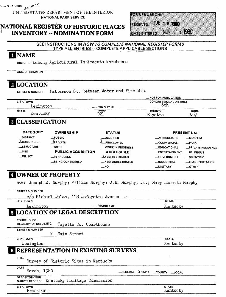
:ormNo. 10-300
UNITED STATES DEPARTMENT OF THE INTERIOR NATIONAL PARK SERVICE
NATIONAL REGISTER OF HISTORIC PLACES 1 INVENTORY -- NOMINATION FORM
SEE INSTRUCTIONS IN HOW TO COMPLETE NATIONAL REGISTER FORMS __________TYPE ALL ENTRIES -- COMPLETE APPLICABLE SECTIONS______
[NAMEHISTORIC DeLong Agricultural Implements Warehouse
AND/OR COMMON
LOCATIONSTREET& NUMBER Patterson St. between Water and Vine Sts.
—NOT FOR PUBLICATIONCITY, TOWN
Lexington __STATE Kentucky
CATEGORY—DISTRICT ABUILDING(S)
—STRUCTURE
—SITE
—OBJECT
TION
OWNERSHIP—PUBLIC
-JPRIVATE
—BOTH
PUBLIC ACQUISITION_IN PROCESS
—BEING CONSIDERED
.VICINITY OFCODE021
STATUS—OCCUPIED
^-UNOCCUPIED
—WORK IN PROGRESS
ACCESSIBLEJCYES: RESTRICTED
— YES: UNRESTRICTED
_NO
CONGRESSIONAL DISTRICT6th
COUNTY CODEPayette 06?
PRESENT USE_ AGRICULTURE —MUSEUM
—COMMERCIAL —PARK
—EDUCATIONAL —PRIVATE RESIDENCE
—ENTERTAINMENT —RELIGIOUS
—GOVERNMENT —SCIENTIFIC
—INDUSTRIAL —TRANSPORTATION
—MILITARY _J9THER.
OWNER OF PROPERTYNAME Joseph E. Murphyj William Murphy; O.B. Murphy, Jr.; Mary Lanetta Murphy
STREET & NUMBER
c/0 Michael Dolan, 118 Lafayette Avenue______________________CITY, TOWN
Lexington VICINITY OFSTATE
KentuckyLOCATION OF LEGAL DESCRIPTIONCOURTHOUSE,REGISTRY OF DEEDS.ETC. Fayette Go. CourthouseSTREET & NUMBER
W. Main StreetCITY, TOWN
LexingtonSTATE
Kentucky
REPRESENTATION IN EXISTING SURVEYSTITLE
Survey of Historic Sites in KentuckyDATE
March, 1980 —FEDERAL .INSTATE —COUNTY —LOCAL
DEPOSITORY FORSURVEY RECORDS Kentucky Heritage CommissionCITY, TOWN
FrankfortSTATEKentucky

DESCRIPTION
CONI
—EXCELLENT
—GOOD
X-FAIR
DITION
—DETERIORATED
—RUINS
_ UNEXPOSED
CHECK ONE
^UNALTERED
—ALTERED
CHECK ONE
JLoRIGINALSITE
MOVED DATF
DESCRIBE THE PRESENT AND ORIGINAL (IF KNOWN) PHYSICAL APPEARANCE
The DeLong Agricultural Implements Warehouse is one of two "brick ware houses at the ends of a long, narrow block at the west end of downtown Lexington between Patterson and Merino, Water and Vine Streets. The latter two streets (which have been consolidated as Vine St. in the downtown area proper and now exist separately only in the warehouse block) flank the channel of the Town Branch, or South B^ork of Elkhorn Greek, here covered over but still running under the warehouses and the vacant lot between them; the stream is visible only under the arches at the ends of the structures. The 1913 Milton Sanchez Storage Warehouse at the Merino St. end of the block is being nominated to the Register separately at this time.
This block is located in a valley between W. Main St. to the north and W. High St. to the south, only a block away in either direction. Along the ridges are the Western Suburb Historic District (listed on the National Register June 18, 1976) to the north and the Botherum Neighborhood Historic District (nominated to the Register June, 1980) to the south. At the present four warehouses and a truncated portion of the former L £ N Freight Depot remain in the valley west of Patterson (originally Lower) St. The valley is crossed to the west of this block by the Jefferson St. viaduct, now under reconstruction. The viaduct separates this area from the somewhat broader western valley of Town Branch, which is open and meanders along railroad tracks between the remains of single-story tobacco warehouses, distilleries, and other commercial industrial facilities, flanking Manchester Avenue, an old but deteriorated residential area long associated with the industry in this area. Sast of Patterson St. is the high wall of the recently completed Lexington Civic Center Rupp Arena and its loading docks. (The other two later twentieth-century warehouses and remains of the depot are not being nominated at this timeO
The DeLong Warehouse, at the eastern, Patterson St., end of the block,is 44 feet wide and about 150 feet long (see Photos 1 and 2). It is now four stories high, with the first floor 16' tall and the others 12' high, although the top story may have been somewhat truncated or raised and the interior ceiling height follows the low slope of the roof. There are five very widely-spaced baps on the north and south sides, with approximately four bays on the east end and a blank west wall, where the outline of the earlier iron-clad attachment still shows (see -Photo 3)- The outside walls are of industrial brick, mostly in 1/7-course common bond, with rough stone foundations. The original openings are segmental-arched, with two rows of headers in me>©t cases, although the north and south windows of the fourth story now have flat arches of headers just under the roof line and the wider central south entrance has three-row arches,- two wide delivery openings have been added rather roughly on the south/side. There are six-pointed star steel tie-rot ends on the north and south sides./ Most of the windows retain well-proportioned 6/6-pane sash with fine narrow muntins.
The interior is very plain but well constructed with large-scale members. A row of large timber posts runs east-west down the center of each story on 10^* centers, supporting huge horizontals, which interlock over the supports with extended "capitals" between. The joists are also unusually large. The board flooring is laid on the diagonal. There is a freight elevator inside at the east end, and a staircase in the northwest corner. The roof-support system on the fourth floor has much smaller joists and support timbers in approximately the same pattern as those below.
(Cont.)

01 SIGNIFICANCE
PERIOD—PREHISTORIC
—1400-1499
—1500-1599
—1600-1699
— 1700-1799
JLl800-1899
—1900-
AREAS OF SIGNIFICANCE -- CHECK AND JUSTIFY BELOW—ARCHEOLOGY-PREHISTORIC
_ARCHEOLOGY-HISTORIC
—AGRICULTURE
—^^ARCHITECTURE
—ART
—^COMMERCE ;
—COMMUNICATIONS
—COMMUNITY PLANNING
—CONSERVATION
—ECONOMICS
—EDUCATION
—ENGINEERING
—EXPLORATION/SETTLEMENT
—INDUSTRY
—INVENTION
—LANDSCAPE ARCHITECTURE
—LAW
—LITERATURE
—MILITARY
—MUSIC
—PHILOSOPHY
—POLITICS/GOVERNMENT
—RELIGION
—SCIENCE
—SCULPTURE
—SOCIAL/HUMANITARIAN
—THEATER
—TRANSPORTATION
—OTHER (SPECIFY)
SPECIFIC DATES probably 1881 or earlier BUILDER/ARCHITECT
STATEMENT OF SIGNIFICANCE
The DeLong Agricultural, Implements Warehouse is probably the oldest basically intact fliuMb-story storage facility in Lexington and has a closed form distinctly different from that of later warehouses. A structure of similar size and shape perhaps a hemp and bagging factory operated by some of the greatest horsemen in Kentucky history appears on the 1871 Bifcd's-Sye View of Lexington at this location, directly over the Town Branch or South Fork of Blkhorn Creek, which still flows beneath it. Although there is some confusion as to the height of the building and both deed and directory research are difficult in the case of such industrial structures, there is every likelihood that the present building corresponds to the brick warehouse acquired in 1881 by the DeLong Agricultural Implements Company one of the most representative and significant in Blue Grass economy in the late 19th century. After the turn of the century it served various purposes and changed hands several times, perhaps as part of the storage complex that included .the larger^ and' mtieh more ; modern fireproof warehouse built for Milton Sanchez in 1913 at the western end of the same block. Later the DeLong warehouse was part of the extensive facilities of the Union Transfer and Storage Company, in the family of whose founder it still belongs, although it is currently being considered for imaginative adaptive use along with the Sanchez building.
The DeLong Warehouse is located directly over the Town Branch, the South Pork of Blkhorn Creek that originates near Lexington, which was founded here partly because of it and its springs; it empties? ultimately into the Kentucky River. Two streets, Water and Vine, originally flanked the course of the stream in the downtown section of the city, crossed by bridges at several points. When the stream was covered over a series of narrow blocks resulted, on which were erected long, narrow buildings that included in the 19th century the City Hall and Market House and a number of ware houses. The westernmost of these was the DeLong Warehouse or its predecessor on the site (shown on the 1871 Bird's-Sye View of Lexington; see Map l). The stream still passes under the warehouse, with arches visible at the base of the end walls. In the 19th century the Town Branch continued westward uncovered, passing under a "Stone Bridge" at Merino St., the western boundary of this block.
Most of the rest of this long block the only one surviving since Water and Vine were combined to form the present wall-like Vine St. between Broadway and Rose Sts. in the 1970s is occupied by the Milton Sanchez Storage Warehouse, erected in 1913 (see separate National Register nomination form); the lower portion of the stream and the bridge were covered over to provide access by freight cars to this new warehouse. An iron-clad one-story structure, probably a cooper's shop, had been attached to the south side of the DeLong warehouse in its later years; this was eventually removed, leaving a gap between the two tall brick structures, which remains.
(Cont.)

IMAJOR BIBLIOGRAPHICAL REFERENCES
See continuation sheet.
ACREAGE NOT HIED3GEOGRAPHICAL DATA
ACREAGE OF NOMINATED PROPERTY __ « 1214 acre
UTM REFERENCES
UTM NOT VERIFIEDtQ I U i2J1 i2All 16 I \7 ll iQ Jl
ZONE EASTING NORTHINGcl i I I I . I , . I I , I . I , , 1
Bl . I M . I . . I I . IZONE EASTING NORTHING
p| . I MilJ_!
. . I I I I i i . . 1
VERBAL BOUNDARY DESCRIPTION
Beginning at the northwest corner of Eatterson (formerly Lower) and Old West Vine Streets, proceed 44 feet north along the east edge of the building on Patterson St.j then west along the north edge of the "building on Water St.; then south along the west edge of the building; then east along the south edge of the building on W. Vine St. to the starting point.
STATE CODE COUNTY CODE
ORGANIZATION
Lexington-Fayette Go. Historic Comm.DATE
TELEPHONE
STATE
Kentucky
STATE HISTORIC PRESERVATION OFFICER CERTIFICATIONTHE EVALUATED SIGNIFICANCE OFTHIS PROPERTY WITHIN THE STATE IS:
NATIONAL__ STATE___ LOCAL y
As the designated State Historic Preservation Officer for the National Historic Preservation Act of 1966 (Public Law 89-665), I hereby nominate this property for inclusion in the National Register and certify that it has been evaluated according to the criteria and procedures set forth by the National Park Servk
GPO 892-453

Form No. 10-300a (Hev. 10-74)
UNITED STATES DEPARTMENT OF THE INTERIOR NATIONAL PARK SERVICE
NATIONAL REGISTER OF HISTORIC PLACES INVENTORY - NOMINATION FORM
CQNTiNUATiONSHEETpeLong Warehouse ITEM NUMBER ? PAGE 2________________
The structure is basically sound, although there are serious water leaks on the upper floors and maintenance has been desultory for some years. A number of windows panes are missing and frames damaged, and as mentioned there have been various alterations to the entrance on both north and south sides, although at least one original entrance probably to an office area remains at the west end of the south side between window bays (see Photo ty).
The walls and foundations of the building are only slightly within the boundaries of the lot (and viturally aligned with it; see Map IV), which are therefore used as the boundaries of the area nominated. They are consistently described in the deeds as being 44 feet wide and 120 feet long, a total of 5,280 square feet.
Form No 10-300a (Hev. 10-74)
UNITED STATES DEPARTMENT OF THE INTERIOR NATIONAL PARK SERVICE
NATIONAL REGISTER OF HISTORIC PLACES INVENTORY -- NOMINATION FORM
CONTINUATION SHEET DeLong Warehouse ITEM NUMBER 8. PAGE 2 ___ __
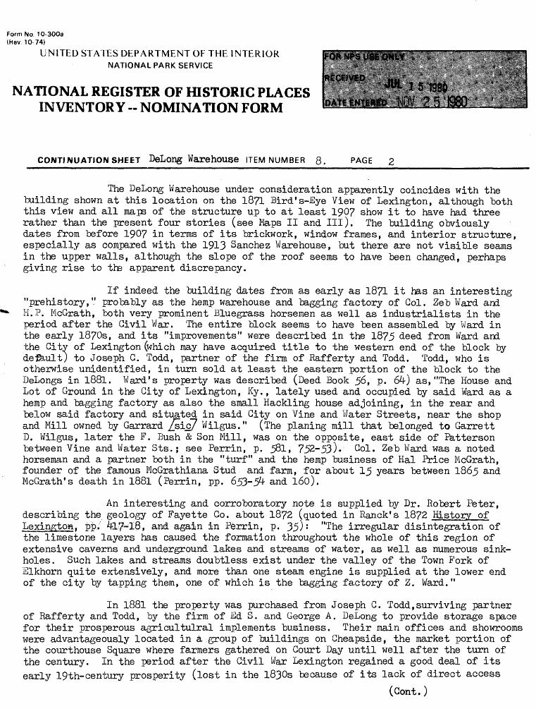
The DeLong Warehouse under consideration apparently coincides with the building shown at this location on the 18?1 Bird's-Eye View of Lexington, although both this view and all maps of the structure up to at least 190? show it to have had three rather than the present four stories (see Maps II and III). The building obviously dates from before 190? in terms of its brickwork, window frames, and interior structure, especially as compared with the 1913 Sanchez Warehouse, but there are not visible seams in the upper walls, although the slope of the roof seems to have been changed, perhaps giving rise to the apparent discrepancy.
If indeed the building dates from as early as 1871 it has an interesting "prehistory," probably as the hemp warehouse and bagging factory of Gol. Zeb Ward and H.P. McGrath, both very prominent Bluegrass horsemen as well as industrialists in the period after the Civil War. The entire block seems to have been assembled by Ward in the early 1870s, and its "improvements" were described in the 1875 deed from Ward and the Citv of Lexington (which may have acquired title to the western end of the block by del&ult) to Joseph C. Todd, partner of the firm of Rafferty and Todd. Todd, who is otherwise unidentified, in turn sold at least the eastern portion of the block to the DeLongs in 1881. Ward's property was described (Deed Book 56, p. 64) as,"The House and Lot of Ground in the City of Lexington, Ky., lately used and occupied by said Ward as a hemp and bagging factory as also the small Hackling house adjoining, in the rear and below said factory and situated in said City on Vine and Water Streets, near the shop and Mill owned by Garrard /sic? Wilgus." (The planing mill that belonged to Garrett D. Wilgus, later the F. Bush & Son Mill, was on the opposite, east side of Patterson between Vine and Water Sts.j see Perrin, p. 581. 752-53)- Gol. Zeb Ward was a noted horseman and a partner both in the "turf" and the hemp business of Hal Price McGrath, founder of the famous McGrathiana Stud and farm, for about 15 years between 1865 and McGrath's death in 1881 (Perrin, pp. 653-54 and 160).
An interesting and corroboratory note is supplied by Dr. Robert Peter, describing the geology of Fayette Go. about 1872 (quoted in Ranck's 1872 History of LexingtoH, pj>> 4l7-iQ» and again in Perrin, p. 35) : "The irregular disintegration of the limestone layers has caused the formation throughout the whole of this region of extensive caverns and underground lakes and streams of water, as well as numerous sink holes. Such lakes and streams doubtless exist under the valley of the Town Fork of Elkhorn quite extensively, and more than one steam engine is supplied at the lower end of the city by tapping them, one of which is the bagging factory of Z. Ward."
In 1881 the property was purchased from Joseph G. Todd,surviving partner of Rafferty and Todd, by the firm of Ed S. and George A. DeLong to provide storage space for their prosperous agricultulral implements business. Their main offices and showrooms were advantageously located in a group of buildings on Gheapside, the market portion of the courthouse Square where farmers gathered on Court Day until well after the turn of the century. In the period after the Civil War Lexington regained a good deal of its early 19th-century prosperity (lost in the 1830s because of its lack of direct access
(Cont.)

Form No. 10-300a (Hev. 10-74)
UNITED STATES DEPARTMENT OF THE INTERIOR NATIONAL PARK SERVICE
NATIONAL REGISTER OF HISTORIC PLACES INVENTORY -- NOMINATION FORM
Belong WarehouseCONTI NU ATION SHEET_______________. ITEM NUMBER 8- PAGE 3______________________
to the Ohio-Mississippi River system that dominated western transportation from the 1810s until the 1850s). This recovery was largely owing to its increasing role as a railroad center for the entire Blue Grass region of central Kentucky, and for much of eastern Kentucky as well toward the turn of the century. The agricultural wealth of the region, particularly in hemp and tobacco as well as the horse industry, was the major source of this prosperity. The DeLong firm was an integral part of this develop ment, and this particular warehouse was conveniently located next to the L & N Freight Depot (whose replacement remains, in sadly truncated form, directly southwest of this block).
The DeLongs and their business were described in a number of late 19th-century local commercial and biographical sources, including Perrin (l882, pp. 600-601), Ranck's Guide (1883, p. 66, where he calls it "the oldest of its kind in the city")* his Review (l88?, p. 102), the Transcript (8/25/85), and an article in The Lexington Leader (4/30/1893, P- 27), as well as the obituaries of the firm's principals, E.S. and G.H. DeLong. Edward S. DeLong (l842~99; obit., Her., 6/19/1899, 1-5) came to Lexington from southwestern Kentucky in 1862, worked as a bookkeeper and (wholesale) grocer, and entered the agricultural implements business in 1870. In 1874 his brother, George Allie DeLong (lS44~1910; obit., Her.. 4/13/1910, 1-1); joined him in the firm of DeLong & Co., which prospered at least until the mid-l890s.
A number of accounts of the firm mention that their business had grown so that by 1881 they were forced to acquire the (then) three-story brick warehouse at Water and Vine Sts., whose dimensions were usually given as about 44 by 150 feet, in addition to a two-story warehouse formerly on the west end of the block (on the site of the Sanchez building), their showrooms on Gheapside, and additional storage else where. Perrin reported that "They have, by strict attention to business, gradually built up their trade to colossal proportions, being, without doubt, the largest retail dealers in agricultural implements in the state." The 1893 writer went so far as to state that "The importance of Lexington as a commercial center is ably illustrated in, the immense and growing business interests of DeLong & Co., wholesale and retail dealers in farm implements, hardware, harness, buggies, wagons, seeds, etc.": many of their ingenious and practical farm machines were listed and illustrated in contemporary sources.
Nevertheless, it appears that in the 1890s both brothers turned toward the real estate and insurance business, conducting separate firms. Edward had also served as a City Councilman for at least three terms after 1866, and later as Superintendent of Public Works. George was Superintendent of County Education in the significant post-Civil War era when the modern public school system, providing education for both
(Gont.)

Form No. 10-300a (Hev. 10-74)
UNITED STATES DEPARTMENT OF THE INTERIOR NATIONAL PARK SERVICE
NATIONAL REGISTER OF HISTORIC PLACES INVENTORY « NOMINATION FORM
^CONTINUATION SHEET DeLong Warehouse ITEM NUMBER 8« PAGE ^ __ _____
whites and blacks, was beginning to develop. He was also active in civic and financial affairs, as well as the turn-of-the-century real estate development of the city.
After consolidating the ownership after his brother's death at the turn of the century, George A. DeLong sold the property in 1906 for $2,000 to John M. Kelly and his wife. Kelly had been a partner in the wholesale grocery business with J.R. Howard at the turn of the century (see Survey form for Howard's residence, ^5 W» 2nd St. in the Northside). In 1912-13 he was listed as a merchandise broker and was president of the Merchants' Transfer Co., which seems to have become the basis of operations for "commercial genius" Milton Sanchez. In 1918 the Kellys apparently gave the DeLong property for $1 to the Trustees of St. Peter's Roman Catholic Church, who were then contemplating erection of the present sanctuary at l4l Barr St. They in turn sold it on 1920 to the So-Good Candy Manufacturing Co. (possibly one of Sanchez' subsidiary firms) for $16,000. This increase in price from 1906 suggests that the warehouse may have been rebuilt or renovated (accounting for the fourth story that appears on subsequent Sanborn maps) as a part of the Sanchez complex sometime in the 1910s, although the So-Good company resold it for only $7,500 in 1923 to members of the Hegarty family (a Hagarty Brokerage Co. was also one of the early tenants of the Sanchez Building). They finally sold it in 19^6 to the family of the present owners, the Murphys.
Thus, after some years of apparent disuse (and a variety of tenants, some of whose names still appear overlaid on the east wall of the building; see Photo 2), the warehouse was eventually incorporated in the holdings of Milton Sanchez and his successor firm, the Union General Transfer & Storage Co., whose president and general manager was Owen Benedict Murphy, Sr. (see Map IV). According to his obituary (Herald. ^/1/19^7, 1-6, aged 70 J, Murphy had been engaged in the trucking business for 5^ years, overseeing the growth of his company from a modest start to one of the largest trucking and storage concerns in Kentucky.
After the senior Murphy's death the structure, which has survived the destruction of many other downtown and near-downtown industrial-storage facilities, became increasingly neglected. Now, however, its sturdy structure, its ample interior spaces, and its advantageous location adjacent to the Civic Center, the Mary Todd Lincoln Home, and other increasingly popular older residential districts, as well as its own significant role in the economic history of the region, make it a prime candidate for adaptive use.

Form No. 10-300a (Rev. 10-74)
UNITED STATES DEPARTMENT OF THE INTERIOR NATIONAL PARK SERVICE
NATIONAL REGISTER OF HISTORIC PLACES INVENTORY - NOMINATION FORM
DeLong Agricultural Implements Warehouse Fayette County, Kentucky
CONTINUATION SHEET ITEM NUMBER 0 PAGE
STATEMENT OF SIGNIFICANCE
The DeLong Agricultural Implements Warehouse is the only surviving example of a large-scale late 19th-century storage warehouse in Lexington. With its relatively small sash windows on extensive brick wall surfaces, timber interior construction, and rather primitive vertical circulation, it provides a representative of the standard warehouse type prior to the more sophisticated "fireproof" brick warehouses of the 20th century, such as the nearby Milton Sanchez General Storage Co., Van Deren Hardware Co., and W. T. Sistrunk Grocery warehouses in the vicinity, which have more extensive window areas, specialized machinery, formal* offices, complex access, and some early 20th-century stylistic features. The DeLong Warehouse is also by far the oldest in this group of warehouses located over and along the former Town Branch of Lexington, as well as adjacent to the former L & N railroad tracks and freight depot, in the historically industrial area west of the downtown business district.
The DeLong Warehouse is somewhat deteriorated in condition, but basically intact and suited for re-use or adaptive use. Although it may have been all or partially present shortly after the Civil War, and the present top story may have been added before 1907, there is every likelihood that the structure was erected by 1881 for the DeLong Agricultural Implements Co., the leading firm dealing in a wide variety of vehicles, machinery, tools, seeds and grains, and other agricultural necessities in the Blue Grass Region during the last quarter of the 19th century a period when agriculture with its associated activities was the dominant industry in the area.


Map 1 - Detail of 187L Bird's-Eye View of Lexington
Dates 18?1 Scale i Unknown
NOM

o f,
C —
cr
L_-
! I
t i
1
I
» 5
A.-<
1 / i
- * '.
7 i/ T
.'jy
/ /
I
F""
1""--™
SB
^C^»
h-^-
3-.V
;^/- /r -
^ J>
0 *
J rt
7
t
'•<2T
NO <4
N
_ap
'i I
IV
)
:£ze
*H r
••/
\
-X i i O o
&C
Z

DeLong Agricultural Implements WarehouseLexingtonFayetteKentucky
Map 2 - Detail of 1886 Sanborn Insurance map University of KentucJsy Scales I

1
SJ
.43
H
>»5
1^'
S?^i^
31

BeLong Agricultur&A Implements WarehouseLexingtonFayetteKentucky
Map 3 - Detail of 1901 Sanborn Insurance Map University of Kentucky
Seals s I'VLOO'-


WarehouseFayette Kentucky
Date *. 1976

PART OFT
FAVETTE CO. KY.
Sca.Lc 'i%.3 feet to tfic Inc~h.
\
DeLong Agricultural Implements WarehouseLexingtonFayetteKentucky
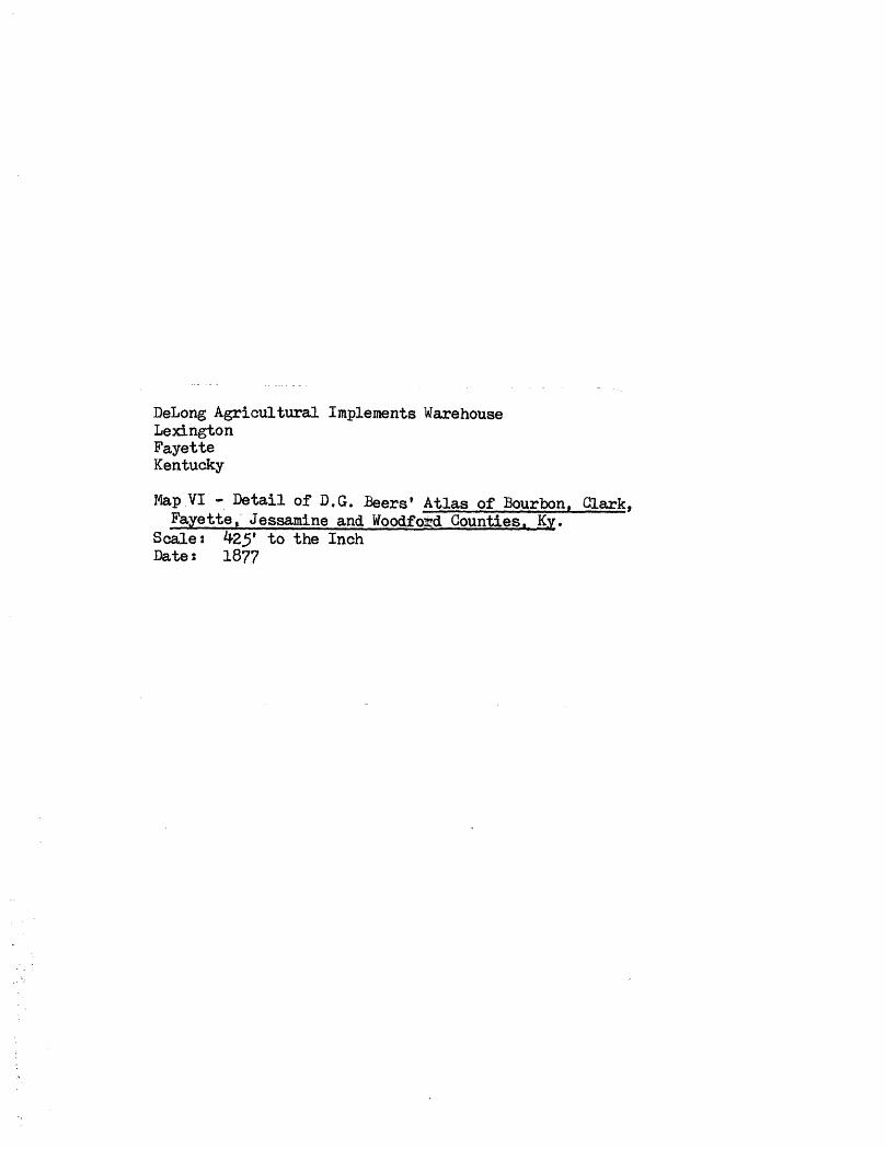
Map VI - Detail of D.G. Beers' Atlas of Bourbon, dark.Fayette, Jessamine and tfoodfo&d Counties. Ky.
Scales 425' to the Inch Dates 1877