pace multi-angle polarimetry update
TRANSCRIPT

PACE Multi-angle polarimetry update
Kirk KnobelspiessePACE Science & Applications Team meeting
October 7, 2021
1. Algorithm developmenta) Overviewb) Data product selection processc) Documentationd) Validation
2. Simulator and synthetic data production3. Project science activities4. Presentations5. Frontiers journal special issue

1. Algorithm developmenta) Overviewb) Data product selection processc) Documentationd) Validation
2. Simulator and synthetic data production3. Project science activities4. Presentations 5. Frontiers journal special issue
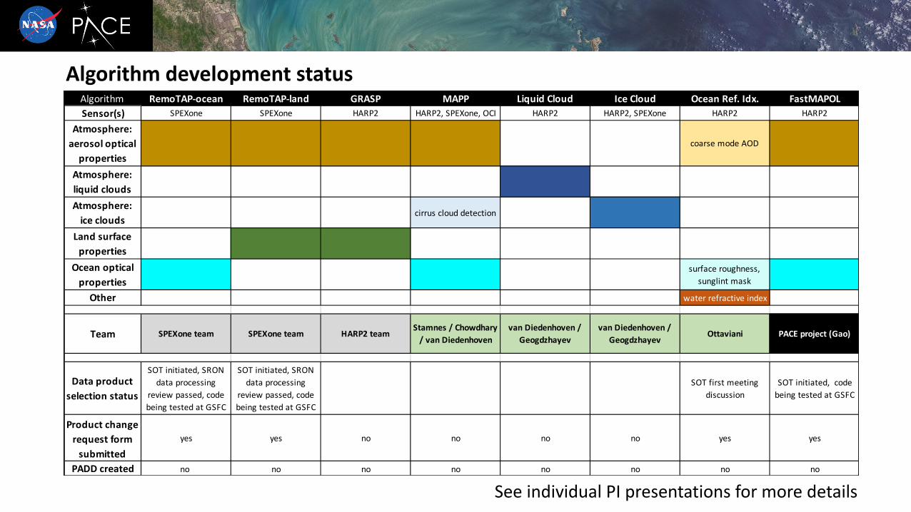
Algorithm development statusAlgorithm RemoTAP-ocean RemoTAP-land GRASP MAPP Liquid Cloud Ice Cloud Ocean Ref. Idx. FastMAPOL
Sensor(s) SPEXone SPEXone HARP2 HARP2, SPEXone, OCI HARP2 HARP2, SPEXone HARP2 HARP2
Atmosphere:
aerosol optical
properties
coarse mode AOD
Atmosphere:
liquid clouds
Atmosphere:
ice cloudscirrus cloud detection
Land surface
properties
Ocean optical
properties
surface roughness,
sunglint mask
Other water refractive index
Team SPEXone team SPEXone team HARP2 teamStamnes / Chowdhary
/ van Diedenhoven
van Diedenhoven /
Geogdzhayev
van Diedenhoven /
GeogdzhayevOttaviani PACE project (Gao)
Data product
selection status
SOT initiated, SRON
data processing
review passed, code
being tested at GSFC
SOT initiated, SRON
data processing
review passed, code
being tested at GSFC
SOT first meeting
discussion
SOT initiated, code
being tested at GSFC
Product change
request form
submitted
yes yes no no no no yes yes
PADD created no no no no no no no no
See individual PI presentations for more details

• See data product selection plan: https://pace.oceansciences.org/docs/TM-20205007069-2020-219027-Vol.-8-PACE_vol8.pdf
• First submit a “Science Product Change Request” then have a review by the Science Operations Team (SOT). They start the process of implementation and testing.
• Science Operations Board (SOB) approves when ready.
• Also needs a Product and Algorithm Description Document (PADD, like ATBD, but as a living document).
• So far, we have started the process for • RemoTAP: the SRON/SPEXone aerosol algorithm
• FastMAPOL: the project science aerosol algorithm (Meng Gao)
• PI Matteo Ottaviani for his ocean refractive index algorithm.
Making an algorithm? Start the data product selection process!
PACE DPSP

Product and Algorithm Description Document (PADD) example

Product and Algorithm Description Document (PADD) example

Algorithm developers: how will you validate your algorithm?
Currently available validation data Validation after PACE launch
Airborne data, such as ACEPOL
Data description paperDOI: 10.5194/essd-12-2183-2020
Data archive @ ASDC DAAChttps://asdc.larc.nasa.gov/soot/power-user/ACEPOL/2017
Simulated data, such SPEXone L1C
https://pace.oceansciences.org/docs/PACE_Validation_Plan_14July2020.pdf
PACE Validation Plan (PVP) PACE Validation Plan – July 2020
National Aeronautics and
Space Administration
Goddard Space Flight Center Greenbelt, Maryland
Plankton, Aerosol, Cloud, ocean Ecosystem (PACE) mission
PACE Science Data Product Validation Plan
PACE Postlaunch Airborne eXperiment (PACE-PAX)
See my talk 9:40-10:00am Friday

1. Algorithm developmenta) Overviewb) Data product selection processc) Documentationd) Validation
2. Simulator and synthetic data production3. Project science activities4. Presentations5. Frontiers journal special issue

Simulators and synthetic data
Pengwang Zhai’s PACE radiative transfer simulator, a coupled atmosphere-ocean model with:• flexible scattering properties for atmosphere and ocean• polarization• trace gas absorption• inelastic scattering
SPEXone simulated data in Level-1c format • AOD & land BPDF from POLDER L2 products• aerosol microphysical properties from ECHAM-HAM simulations• clouds, Chl-a, land BRDF from MODIS L2 products• BRDF spectral dependence from GOME-2
https://oceancolor.gsfc.nasa.gov/data/pace/test-data/
Research Scanning Polarimeter (RSP) airborne data in Level-1c format
• RSP is a line scanner instrument whose capabilities (spectral bands, # of view angles, accuracy) exceeds that of HARP2 and SPEXone
https://data.giss.nasa.gov/pub/rsp/data/PACE/
Research informing the ocean radiative transfer• Mike Twardowski’s ZTT ocean color model incorporating multi-angle and polarimetric aspects• Xiaodong Zhang’s investigations of χ factor improvement with multi-angle measurements

Simulators and synthetic data

1. Algorithm developmenta) Overviewb) Data product selection processc) Documentationd) Validation
2. Simulator and synthetic data production3. Project science activities4. Presentations5. Frontiers journal special issue

PACE Project Science polarimetry relevant activities
Meng Gao’s FastMAPOL neural network-based retrieval algorithm development
• See mini-talk from Wednesday• Recent paper: https://doi.org/10.5194/amt-14-4083-2021
Level-1c (unified sensor) format development• Martin Montes is developing code to create Level-1c files within the
data processing system• Minor changes to format specification. We now include scattering
angle. https://oceancolor.gsfc.nasa.gov/data/pace/format/
Wind speed
Pro
bab
ility
AOD(866nm)
Pro
bab
ility
Fine mode fraction
Pro
bab
ility
Aerosol relative humidity
Pro
bab
ility
MISR 866nm
multi-angle (9)
observations
A priori probability distribution functions (PDFs)
Radiative
transfer
simulations Bayesian -
inference
Wind speed
Pro
ba
bili
ty
AOD(866nm)
Pro
ba
bili
ty
Fine mode fraction
Pro
ba
bili
ty
Aerosol relative humidity
Pro
ba
bili
ty
MISR a posteriori / MODIS a priori probability distribution functions
MODIS multi-spectral
observations
Radiative
transfer
simulations Bayesian -
inference
Rrs(412nm)
Pro
bab
ility
Rrs(443nm)
Pro
bab
ility
Rrs(865nm)
Pro
bab
ility
MODIS a posteriori probability distribution functions
...(updated wind, aerosol PDF’s as a byproduct)
Model
uncertainty
estimates
Data
uncertainty
estimates
Model
uncertainty
estimates
Data
uncertainty
estimates
A
B
C
DE
F
G
H
I
JK
L
M
MODIS Ocean Color with MISR Atmospheric Correction (MOCMAC) project
• Prototype for how we can pass polarimetric ‘knowledge’ to help OCI atmospheric correction
• Proof of concept analysis paper: https://doi.org/10.5194/amt-14-3233-2021
• Refunded to continue with full concept →
MOCMAC Bayesian Inference approach

PACE Project Science summer intern activitiesAdaptation of Mitsuba 2 graphics rendering software for atmosphere/ocean radiative transfer
Katherine SalesinDartmouth College
We adapted the differentiable renderer Mitsuba 2, designed for computer graphics applications, to solve radiative transfer problems relevant toatmosphere and ocean remote sensing and of interest for the upcoming PACE mission. It is capable of both forward simulation (transforming a given set ofparameters into radiance) and inverse simulation via gradient descent optimization (retrieving the parameters that could have created a radiancemeasurement). We validated the accuracy of our forward simulation pipeline against eGAP, an adding-doubling radiative transfer code. Mitsuba 2 iscomputationally efficient and capable of simulating complex 3D scenes and may become an important component of PACE data analysis.
Cloud top height
Cloud droplet radii
Aerosol scattering albedo
Ocean surface roughness
Phytoplankton composition
Parameters Forward simulation
Simulated radiance(Output)
Error / LossGradient Descent
Loop
Inverse simulation
Partial Derivativeswith respect to each parameter
Measured radiance(Target)

PACE Project Science summer intern activities
Sean Foley Georgia Tech
The A-Train Cloud Segmentation Dataset
Multi-angle polarimetric instruments, such as those on the upcoming NASA PACE mission, will need to automatically identify clouds. Mostalgorithms for doing so use radiometric thresholds and spectral information to perform this segmentation, but PACE will have multi-angleand polarimetric information as well. We plan to exploit machine learning techniques, such as Multi-Layer Perceptrons (MLPs) and DCNNs,for this complex analysis. The first step is to assemble a training set, which combines Polarization and Anisotropy of Reflectances forAtmospheric Science coupled with Observations from a Lidar (PARASOL) observations with data from CloudSat. The dataset is formattedfor ease-of-use by machine learning researchers and will be made publicly accessible.
Recent results of neural network training to identify cloud vertical distribution using multi-angle polarimetry (POLDER) Cyan: true positive , blue: false positive , green: false negative , black: true negative

1. Algorithm developmenta) Overviewb) Data product selection processc) Documentationd) Validation
2. Simulator and synthetic data production3. Project science activities4. Presentations5. Frontiers journal special issue
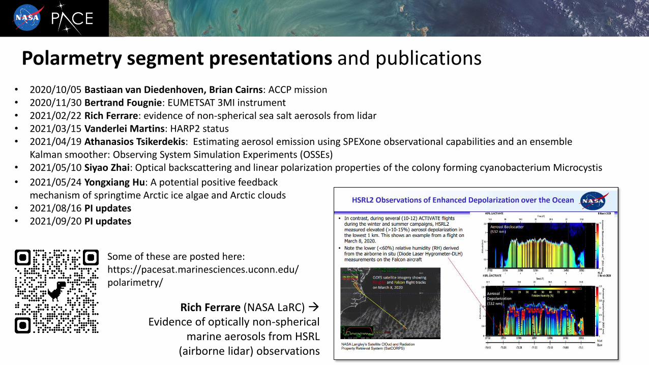
• 2020/10/05 Bastiaan van Diedenhoven, Brian Cairns: ACCP mission• 2020/11/30 Bertrand Fougnie: EUMETSAT 3MI instrument• 2021/02/22 Rich Ferrare: evidence of non-spherical sea salt aerosols from lidar• 2021/03/15 Vanderlei Martins: HARP2 status• 2021/04/19 Athanasios Tsikerdekis: Estimating aerosol emission using SPEXone observational capabilities and an ensemble
Kalman smoother: Observing System Simulation Experiments (OSSEs)• 2021/05/10 Siyao Zhai: Optical backscattering and linear polarization properties of the colony forming cyanobacterium Microcystis
Polarmetry segment presentations and publications
• 2021/05/24 Yongxiang Hu: A potential positive feedback mechanism of springtime Arctic ice algae and Arctic clouds
• 2021/08/16 PI updates• 2021/09/20 PI updates
Rich Ferrare (NASA LaRC) →Evidence of optically non-spherical
marine aerosols from HSRL (airborne lidar) observations
Some of these are posted here: https://pacesat.marinesciences.uconn.edu/polarimetry/

1. Algorithm developmenta) Overviewb) Data product selection processc) Documentationd) Validation
2. Simulator and synthetic data production3. Project science activities4. Presentations5. Frontiers journal special issue

Frontiers in Remote Sensing research topic (special issue)
Polarization of Light as a Tool for Characterizing Different Facets of the
Atmosphere-Ocean System
Due date is soon! October 15th
https://www.frontiersin.org/research-topics/19225/polarization-of-light-as-a-tool-for-characterizing-different-facets-of-the-atmosphere-ocean-system#articles
Thanks!