pacific booker project description
TRANSCRIPT

MMOORRRRIISSOONN CCOOPPPPEERR//GGOOLLDD PPRROOJJEECCTT PPRROOJJEECCTT DDEESSCCRRIIPPTTIIOONN
PPrreeppaarreedd bbyy::
PPaacciiffiicc BBooookkeerr MMiinneerraallss IInncc.. ##11770022 –– 11116666 AAllbbeerrnnii SStt..
VVaannccoouuvveerr,, BB..CC.. VV66EE 33ZZ33
SSuubbmmiitttteedd ttoo::
BB..CC.. EEnnvviirroonnmmeennttaall AAsssseessssmmeenntt OOffffiiccee PPOO BBooxx 99442266 SSttnn PPrroovv GGoovvtt
VViiccttoorriiaa,, BB..CC.. VV88WW 99VV11
December 21, 2005

Morrison Copper/Gold Project
PBM Minerals Inc. December 21, 2005
Table of Contents
1.0 SUMMARY............................................................................................................................................................1
2.0 PROPONENT ........................................................................................................................................................3
3.0 CURRENT PROPERTY STATUS ......................................................................................................................4 3.1 Claims.........................................................................................................................................................7
4.0 HISTORY...............................................................................................................................................................9
5.0 RECENT EXPLORATION WORK..................................................................................................................10
6.0 PROJECT DESCRIPTION................................................................................................................................11 6.1 Geology ....................................................................................................................................................11
6.1.1 Regional Geology ...............................................................................................................................11 6.1.2 Geology of the Morrison Deposit......................................................................................................11 6.1.3 Mineralization ....................................................................................................................................12
6.2 Resources..................................................................................................................................................12 6.3 Mine Plan .................................................................................................................................................13
6.3.1 Mining Methods .................................................................................................................................13 6.3.2 Metallurgy/Processing .......................................................................................................................15
6.4 Waste Disposal .........................................................................................................................................17 6.5 Water Management Plan ..........................................................................................................................19 6.6 Work Force...............................................................................................................................................20 6.7 Schedule....................................................................................................................................................20 6.8 Infrastructure............................................................................................................................................22
6.8.1 Property Access..................................................................................................................................22 6.8.2 Water ..................................................................................................................................................22 6.8.3 Camp...................................................................................................................................................22 6.8.4 Fuel Storage........................................................................................................................................22 6.8.5 Explosive Storage...............................................................................................................................22 6.8.6 Warehouse/Shops...............................................................................................................................22 6.8.7 Roads...................................................................................................................................................23 6.8.8 Concentrate Transportation. ............................................................................................................23
6.9 Power........................................................................................................................................................25 6.10 Reclamation..............................................................................................................................................27
7.0 PLAN FOR FURTHER DEVELOPMENT ......................................................................................................28
8.0 WASTE MANAGEMENT FACILITY .............................................................................................................30 8.1 Overview...................................................................................................................................................30 8.2 Evaluation ................................................................................................................................................30
8.2.1 Criteria ...............................................................................................................................................30 8.2.2 Alternatives investigated ...................................................................................................................30 8.2.3 Site B ...................................................................................................................................................31
8.2.3.1 Conceptual Tailings Disposal Methodology ..............................................................................32

Morrison Copper/Gold Project
PBM Minerals Inc. December 21, 2005
8.2.3.2 General Description....................................................................................................................32
9.0 ENVIRONMENTAL ASSESSMENT PROGRAM..........................................................................................35 9.1 INTRODUCTION.....................................................................................................................................35 9.2 ENVIRONMENTAL ASSESSMENT (EA) PROCESS ...............................................................................35
9.2.1 Regulatory Framework .....................................................................................................................38 9.2.1.1 Provincial ...................................................................................................................................38 9.2.1.2 Federal........................................................................................................................................38
9.3 Public Consultation ..................................................................................................................................39 9.3.1 First Nations Consultation and Participation..................................................................................39
10.0 LAND USE .........................................................................................................................................................41 10.1 ENVIRONMENTAL SETTING AND EFFECTS ASSESSMENT ..............................................................41
10.1.1 Environmental Issues....................................................................................................................43 10.1.2 Surface Water Hydrology and Quality .......................................................................................43 10.1.3 Ground Water Hydrogeology and Quality .................................................................................44 10.1.4 Acid Rock Drainage / Metal Leaching ........................................................................................44 10.1.5 Fisheries and Aquatic Species ......................................................................................................45 10.1.6 Lake and Stream Sediments.........................................................................................................46 10.1.7 Flora and Fauna Studies & Terrestrial Ecosystem Mapping ...................................................46 10.1.8 Surficial Geology & Soils..............................................................................................................47 10.1.9 Seismicity & Terrain Stability .....................................................................................................47 10.1.10 Climate and Air Quality ...............................................................................................................47 10.1.11 Noise ...............................................................................................................................................48 10.1.12 Archaeology, Traditional & Cultural Use...................................................................................48 10.1.13 Socio-Economic Assessment .........................................................................................................48 10.1.14 Public Health & Safety .................................................................................................................49

Morrison Copper/Gold Project
PBM Minerals Inc. December 21, 2005
ABBREVIATIONS ABA Acid – Base Accounting ARD Acid Rock Drainage Au Gold BC British Columbia BCEAA BC Environmental Assessment Act BCEAO BC Environmental Assessment Office BCEMPR BC Ministry of Energy, Mines and Petroleum Resources (formerly Ministry of Energy and
Mines*) BCMAL BC Ministry of Agriculture and Lands (formerly Ministry of Sustainable Resource Management*) BCMOE BC Ministry of Environment (formerly Ministry of Water, Land and Air Protection*) BFP Biotite Feldspar Porphyry CEAA Canadian Environmental Assessment Agency CU Copper CST Cleaner Scavenger Tailings DFO Fisheries and Oceans Canada EC Environment Canada EA Environmental Assessment FISS Fisheries Information Summary System HADD Section 35 of the Fisheries Act, which prohibits the harmful alteration, disruption or destruction
(HADD) of fish habitat HDPE High Density Polyethylene ICP Inductively Coupled Plasma elemental analysis methodology IFPA Innovative Forest Practices Agreements KP Knight Piésold Ltd LBN Lake Babine Nation LRMP Land and Resource Management Plan MEM BC Ministry of Energy and Mines (now BC Ministry of Energy, Mines and Petroleum
Resources*) ML/ARD Metal Leaching / Acid Rock Drainage MLRMP Morice Land and Resource Management Plan MSRM BC Ministry of Sustainable Resource Management (now BC Ministry of Agriculture and Lands*) MWLAP BC Ministry of Water, Land and Air Protection (now BC Ministry of Environment*) NAG Non-Acid Generating Rock NTS National Topographic System PAG Potentially Acid Generating Rock PBM Pacific Booker Minerals Inc. PEM Predictive Ecosystem Mapping PLT Point Load Tests RMR Rock Mass Rating RST Rougher Scavenger Tailings SAG Semi-Autogenous Grinding TOR Terms of Reference WMF Tailings Storage Facility UCS Unconfined Compressive Strength WMF Waste Management Facility XRF X-Ray Fluorescence Spectroscopy elemental analysis methodology

Morrison Copper/Gold Project
PBM Minerals Inc. December 21, 2005 1
1.0 SUMMARY Pacific Booker Minerals Inc. (PBM) owns the Morrison property located in Central British Columbia, 35 km north of the Village of Granisle. PBM is in the advanced stage of a pre-feasibility study to evaluate the Morrison deposit, which is a porphyry copper/gold deposit. The work to date, together with associated studies indicates that the Morrison deposit has the potential to be mined by open pit methods. PBM is proposing an open-pit mining and milling operation for the production of copper/gold concentrate from the Morrison deposit. It is within 30 km of two former producing mines, Bell and Granisle. The Morrison Copper/Gold Project will consist of:
an open pit, a primary crusher, a 25,000 tonne/day processing plant (mill) for production of copper concentrate, a low grade ore stockpile, a conveyor, a waste and tailings disposal site, infrastructure:
o property access, o water, o camp, o fuel storage, o explosives storage, o warehouse/shops, o roads, o concentrate transportation, and
electrical power supply. The mineral resource established is 86,892,094 tonnes grading 0.45% Cu and 0.259gAu/t. The mine will be an open pit mine with an ore production rate of 25,000 tonnes per day or 9 million tonnes of ore per year. The mining operation will utilize conventional truck and shovel equipment. The treatment process will be a conventional crushing, grinding and flotation system resulting in the production of approximately 130,000 tonnes of concentrate per year containing 37,000 tonnes of copper. In addition to the above, low grade material mined as waste, will be stockpiled. It is planned to process this material after the resources shown above are mined out. This will increase the mine life and allow for maximum processing of the available mineralization. The additional resources for processing are estimated at 28,151,658 tonnes with a grade of 0.278% Cu and 0.123gAu/t. Metallurgical test-work carried out indicates that the metallurgy of the Morrison deposit is relatively straightforward and that good copper recoveries and acceptable concentrates can be achieved.
Morrison Copper/Gold Project
PBM Minerals Inc. December 21, 2005 2
The Morrison Copper/Gold Project has the advantage of existing regional infrastructure in place to service the region, including a deep-sea shipping terminal at the port of Stewart, a road network, nearby power (25 km from project site) and a full service town (Granisle) within daily commuting distance from the project site. The Morrison Copper/Gold Project environmental base line studies, fish habitat, water quality and flow measurements, hydrology, wildlife and acid rock drainage (ARD), have commenced as well as the consultative process with the regulators, First Nations and local communities. A drill program is being conducted during the winter of 2005/2006 to complete ore delineation and geo-technical drilling. This program also includes geo-technical drilling for the waste disposal area and condemnation drilling. Detailed design of the pit, process plant, waste disposal system and mine plans; and updated mineral resource estimates will be completed based on the drilling results, optimization and environmental studies. Mine construction is expected to commence in 2007 with production in 2009. The mine life is expected to be 13 years.

Morrison Copper/Gold Project
PBM Minerals Inc. December 21, 2005 3
2.0 PROPONENT PBM is a public traded company listed on the TSX Venture Exchange (Trading Symbol: BKM). PBM owns the Morrison property located in Central British Columbia. In 1997 PBM entered into an agreement with Noranda Inc. to obtain a 50% interest in the Morrison property. PBM subsequently purchased the Morrison property from Falconbridge Limited (formerly Noranda Inc.) in April 2004, with no net smelter return or concentrate commitments to Falconbridge Limited. The Company maintains its head office in Vancouver as follows: Pacific Booker Minerals Inc. 1702-1166 Alberni Street Vancouver, BC V6E 3Z3 Canada Phone: 604 681-8556 Fax: 604 687-5995 Toll Free: 800-747-9911 E-mail:[email protected] Web: www.pacificbooker.com The Company is managed under the direction of its President, Chief Executive Officer and Chief Financial Officer as follows: Mr. GREGORY R. ANDERSON, President& CEO Mr. MICHAEL F. K. MEWS, CFO Mr. JOHN PLOURDE, Investor Relations Mr. ERIK TORNQUIST, Site Manager The Company management in turn operates under the direction of a seven member Board of Directors as follows: Mr. WILLIAM DEEKS, Chairman of the Board Mr. GREGORY R. ANDERSON, President& CEO Mr. JOHN PLOURDE, Executive Director Mr. MICHAEL F. K. MEWS, Executive Director Mr. ERIK TORNQUIST, Executive Director Mr. MARK GULBRANDSON, Executive Director Mr. WILLIAM F. WEBSTER, Executive Director. The Company through the Board reports regularly to its shareholders, the owners of the Company, as required under the Toronto Venture Exchange public disclosure requirements

Morrison Copper/Gold Project
PBM Minerals Inc. December 21, 2005 4
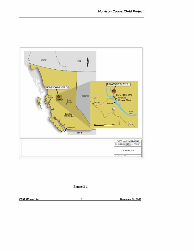
3.0 CURRENT PROPERTY STATUS The majority of the resources contained within the Morrison deposit can be categorized as measured and indicated and the deposit is considered to have potential for development utilizing surface extraction methods and conventional flotation processing to produce a copper/gold concentrate. Beacon Hill Consultants (1988) Ltd. (Beacon Hill) and Knight Piésold Ltd. (KP) have completed a preliminary assessment of the Morrison Deposit to establish mineable ore reserves, mine production rate, evaluate the waste disposal areas, determine the infrastructure requirements, assess the potential viability and establish a development program for the property. The Morrison property is located on Crown Land 65 km northeast of Smithers and 35 km north of the Village of Granisle within the Traditional Territory of the Lake Babine Nation. It is situated on the east side of the southern end of Morrison Lake within the forest management area of Canadian Forest Products Ltd. (Canfor). The PBM claims covers approximately 9,950 hectares. This area is currently used for forestry activities and has been partially logged and replanted. Coordinates of the Morrison deposit are 55˚ 11′ N Latitude and 126˚ 16′ W Longitude. The National Topographic System (NTS) map sheet that covers the area is 93MO1/W. The Morrison deposit elevation ranges from 794.5 metres above sea level to 890 metres above sea level at the top of the southeast ridge of the deposit. Topography can be characterized as undulating and rolling plateau rising steeply to the east to a ridge dominated by Hearne Hill at an elevation of 1350 metres. Refer to Figures 3-1 and 3-2 for site location and site topography. The property is accessed from the highway that turns north off Highway 16 at Topley to Michelle Bay, then by an all-season barge (which can transport up to 10 fully loaded logging trucks) across Babine Lake from where a main haulage logging road network extends to both PBM’s Camp and the Morrison Deposit. The Morrison deposit is geologically similar to both the nearby Bell and Granisle deposits. The Bell open pit mine operated from 1972-1982 and 1985-1992 producing 77 million tonnes of ore at 0.47% Cu and 0.26gAu/t. The Granisle open pit mine operated from 1966-1982, producing 53 million tonnes at 0.47% Cu, 0.20gAu/t.
Morrison Copper/Gold Project
PBM Minerals Inc. December 21, 2005 5
Figure 3-1

Morrison Copper/Gold Project
PBM Minerals Inc. December 21, 2005 6
Figure 3-2

Morrison Copper/Gold Project
PBM Minerals Inc. December 21, 2005 7
3.1 Claims PBM’s land position consists of 398 claim units in 28 contiguous claims totaling 9,950 hectares as shown on the Claim Map - Figure 3-3. This ground position includes the Morrison property (20 units in 1 claim – ERIN 1) and the Hearne Hill property (378 units in 27 claims). All claims are located within the Omineca Mining Division.

Morrison Copper/Gold Project
PBM Minerals Inc. December 21, 2005 8
Figure 3-3

Morrison Copper/Gold Project
PBM Minerals Inc. December 21, 2005 9
4.0 HISTORY The Morrison Lake area was first explored in the early 1960’s during the initial rush of porphyry copper exploration in the Babine Lake region. Follow up to regional stream sediment sampling in 1962 lead to the discovery of the Morrison deposit in 1963 by Noranda’s exploration group. Trenching of the thin overburden uncovered relatively unweathered chalcopyrite-bearing bedrock in large areas on both sides of the unnamed stream that flows across the centre of the Morrison deposit. Further delineation of the deposit occurred from 1963 to 1973 and included soil geochemical, electromagnetic (EM) and magnetic surveys, trenching and geological mapping, alteration studies and drilling. Noranda completed six diamond drilling programs totaling 13,893 metres in 95 holes. The first 65 holes were drilled from 1963 to 1968 and the remaining 30 holes were drilled in 1973. No further drilling was done until PBM optioned the property in October, 1997. PBM conducted a National Instrument 43-101 compliant, three-phase drilling program, which commenced in January 1998 in order to:
Establish grade and continuity of copper values, Establish gold grades, and Explore the depth potential of the copper/gold bearing system.
Eighty-two diamond drill holes totaling 22,824 m were completed by July 2002. The results of the drill program confirmed improved copper/gold values and extended the size of the deposit.
A Preliminary Assessment of the Morrison Copper/Gold Project, Morrison Deposit, August 1, 2004, was prepared by Beacon Hill Consultants (1998) Ltd. The report states “It can be concluded from the results of this preliminary assessment that there is potential for a viable open pit mining operation at the Morrison Cooper/Gold Project.”
The mineral resource established in this study is 86,892,094 tonnes grading 0.45% Cu and 0.259gAu/t. In addition, low grade material mined as waste, will be stockpiled and processed after the resources shown above are mined out. The additional resources for processing are estimated at 28,151,658 tonnes grading 0.278% Cu and 0.123gAu/t.

Morrison Copper/Gold Project
PBM Minerals Inc. December 21, 2005 10
5.0 RECENT EXPLORATION WORK PBM’s work on the Morrison property, consisting mainly of diamond drilling, has been carried out in phases, the last of which was completed in September of 2003. The Phase I drilling program was carried out between 1998 and 2000 and comprised 11 holes totaling 3,818 metres. The Phase II drilling program, carried out in 2000 and early 2001 also utilizing NTW core size, consisted of 13 holes totaling 3,181 metres. It further defined and extended the Morrison deposit. The exploration program also consisted of geophysics (Induced Polarization and Magnetometer surveys) and trenching. Phase III commenced in July 2001 and consisted of completely defining the deposit using 45˚ angle holes at 60-metre spacing. The program was completed in July 2002. Upon completion of Phase III, PBM had drilled 82 holes totaling 22,824 metres at Morrison property. Most of the drilling was NTW size with a small proportion being HQ. This data was used to define the resource on which the viability of the project has been determined. In addition to the foregoing and during the summer of 2003, 8 definition and geo-technical holes were drilled for a total of about 2420 metres Snowden Mining Industry Consultants completed a report entitled “Morrison Copper/Gold Project Resource Estimation and Pit Optimization Study” in March 2003. This study indicated that under favourable economic conditions, an open pit mine at Morrison should generate an economic return. In 2004 a Preliminary Assessment of the property was conducted by Beacon Hill Consultants (1988) Ltd. and Knight Piésold Ltd. The result of this study indicated that the project had the potential to be viable and that the property should be further developed and, subject to further study, be placed into production. Key elected officials, ministry and agency personnel, the Lake Babine Nation and other interest groups have been briefed and periodically updated regarding progress on the project to ensure that subsequent environmental assessment and permitting activities are performed properly and expeditiously. Four PQ holes, totaling 700 metres, were completed in March/April 2005 to provide samples for metallurgical test-work, which was completed in October 2005. Additional definition and geo-technical drilling totaling about 3000 metres is planned for during the winter of 2005.

Morrison Copper/Gold Project
PBM Minerals Inc. December 21, 2005 11
6.0 PROJECT DESCRIPTION 6.1 Geology 6.1.1 Regional Geology The Morrison deposit is on the northern edge of the Skeena Arch in a region underlain by volcanic, clastic and epiclastic rocks ranging in age from the Lower Jurassic to Lower Cretaceous. These rocks are correlative with the Takla Group, Hazelton Group, Bowser Lake Group, Skeena Group and Sustut Group. They have been block-faulted by a series of post-Eocene, northwesterly-trending series of faults that have created a long linear sequence of horsts and grabens. Some of these structures have been traced over a distance of 100 km. The younger Middle Jurassic to Cretaceous rocks are often preserved in the down-dropped blocks, with the older Lower and Middle Jurassic rocks exposed in the Highlands. Intrusive rocks in the area include the Early Jurassic diorite and granodiorite Topley intrusions, Eocene rhyolite and rhyodacite intrusions, and, most importantly from an economic viewpoint, the Eocene Babine igneous suite which consists of quartz, hornblende, biotite and plagioclase phyric intrusions.
6.1.2 Geology of the Morrison Deposit The Morrison deposit is a zoned annular porphyry copper-gold deposit largely within a multi-phased Eocene ‘Babine type’ biotite feldspar porphyry (BFP) body which intrudes Middle to Upper Jurassic Ashman Formation siltstone and greywackes. The lower part of this sequence is mostly marine pebble conglomerate, interbedded with maroon to greenish grey sandstone and siltstone, which change upwards to deeper water well-bedded shaley argillaceous siltstone and greywacke. The lower marine sequence has abundant bivalves, ammonites, belemnites and fossil wood debris of Middle to Upper Jurassic age. The intrusive BFP at Morrison is very similar to that at other Babine copper deposits. A complete description of the lithology including chemical and microprobe analysis is presented by Carson and Jambor (1975). The BFP intrusive at Morrison is a faulted plug with nearly vertical contacts, which occupies a northwesterly-oriented elliptical area of 900 by 500 metres width. Before block faulting, the plug was roughly circular in plan with a diameter of about 500 metres. Numerous offshoots of the plug, many of which are 1 to 500 m-wide northerly-trending dykes or sills, occur abundantly in the Ashman sedimentary rocks. The unaltered BFP is speckled with abundant 0.25 to 5 mm phenocrysts of plagioclase, biotite and hornblende in a fine-grained matrix of the same materials as well as quartz and K-feldspar. Apatite and magnetite are common accessory minerals.

Morrison Copper/Gold Project
PBM Minerals Inc. December 21, 2005 12
6.1.3 Mineralization The copper zone forms the central core of the Morrison deposit. The zone is predominantly hosted in a potassic altered BFP plug with intercalations of older siltstone. All copper sulphides are primary. Chalcopyrite is the main copper-bearing mineral. The copper mineralization occurs in three principal types; (a) fine-grained disseminated chalcopyrite mineralization probably related to microfractures; (b) chalcopyrite-bearing fractures commonly 1-3 mm wide containing coarser chalcopyrite, and (c) late-stage fracture-filling and disseminated sulphides. Within this lithologic and structural framework, the copper zone is defined by the limits of well-developed copper mineralization with associated gold that consistently grades greater than 0.20% Cu. The peripheral limits of the copper zone are generally abrupt as the copper content declines outward to less than 0.10% Cu within a 40 m-wide margin around the copper zone. The degree of structural development and hydrothermal alteration within the internal core of the copper zone are locally more intense, and these favourable elements contribute to the development of higher-grade zones of copper and gold mineralization. Although the copper to gold ratios may vary within these high grade zones, the copper grades locally are greater than 0.50% Cu, and gold grades frequently range from 0.40 to 0.60gAu/t and up to 1.00gAu/t over short intervals. Minor amounts of bornite occur in the higher grade copper zones as disseminations. Spotty occurrences of galena and sphalerite occur within carbonate-cemented veins within and near the East and West Faults. The Morrison deposit and the surrounding halo contain anomalous quantities of pyrite in excess of 1% indicating the potential for varying degrees of ARD. This is somewhat offset by neutralizing minerals that are apparently fast-reacting carbonate, slow-reacting carbonate and slowly neutralizing silicate minerals. The potential for ARD is under investigation. In any event it is planned that all potentially ARD material will be deposited in the waste disposal area under water. 6.2 Resources Based on classification categories of measured, indicated and inferred the following Table 6-1 lists the resources for the Morrison deposit as estimated:
Table 6-1
Resources by Classification
Classification Resource Tonnes
Grade Cu% Grade gAu/t
Waste Tonnes
S/R
Measured 55,643,752 0.465 0.257Indicated 30,002,067 0.428 0.257Inferred 1,246,275 0.362 0.262
Total 86,892,094 0.450 0.257 125,256,661 1.44
Phase 1 Pit + Phase 2 Pit
In addition to the above low grade material, mined as waste, will be stockpiled. It is planned to

Morrison Copper/Gold Project
PBM Minerals Inc. December 21, 2005 13
process this material after the resources shown above are mined out. This will increase the mine life and allow for maximum processing of the available mineralization. The additional resources for processing are estimated at 28,151,658 tonnes with a grade of 0.278% Cu and 0.123gAu/t. 6.3 Mine Plan Development of the open pit is planned as a two-phase mining operation as shown in Figure 6-1, utilizing conventional truck and shovel equipment. The first phase will be developed in the northwest end of the deposit, encompassing some of the higher-grade ore and will extend down to a depth of approximately 200 metres below surface. Phase 2 will consist of a push back, or expansion, of the first phase pit to the southeast and will extend four benches lower than Phase 1. The planned production rate is 25,000 t/d ore and an average of 36,000 t/d waste over the 10 year life of the pit. In addition the mine life will be extended by an additional three years by processing the low-grade material. 6.3.1 Mining Methods Conventional open pit mining methods will be used incorporating drilling, blasting, loading and haulage. Ore and waste will be drilled and blasted using 270 mm diameter holes drilled on a 8.0m x 8.5m pattern. A 70%/30% emulsion/ANFO mix will be used for blasting, resulting in an estimated powder factor of about 0.26kg/t of material. A combination of 16 cubic metre electric cable shovels and 140 tonne diesel trucks will be used for loading and hauling the ore and waste from the pit to a primary crusher located near the top of the ramp. Crushed waste-material will be transported by conveyor to the main disposal area located some 4 km north of the pit, while the ore will be conveyed to the mill coarse ore stockpile. Mining activities will be conducted on two 12-hour shifts per day, 365 days per year. The owner will purchase and operate the equipment and contractors will be used for pit pre-production development work and specialized services. In addition to the primary mining equipment several pieces of auxiliary and service equipment will be required to maintain haul roads, waste dumps and general pit operations.

Morrison Copper/Gold Project
PBM Minerals Inc. December 21, 2005 14
Figure 6-1

Morrison Copper/Gold Project
PBM Minerals Inc. December 21, 2005 15
6.3.2 Metallurgy/Processing Metallurgical test-works carried out indicates that the metallurgy of the Morrison deposit is relatively straightforward and that good copper recoveries and acceptable concentrates can be achieved. Ore will be processed through a conventional milling circuit consisting of a primary crusher, SAG mill, regrind ball mills and flotation circuit as shown in Figure 6-2. In the processing plant copper will be concentrated by flotation in large tank cells after grinding in a SAG/ball mill circuits, then cleaned and filtered to achieve acceptable shipping moistures without thermal drying. Both ore and waste will be processed through a 60″- 89″ primary crusher located at the pit rim, and then the crushed material will be conveyed to the relevant stockpiles. The waste will be crushed to 300-400 mm before being conveyed about 4 km to the waste disposal area, while the ore will be crushed to 150-200mm and conveyed to the coarse ore stockpile near the mill. Ore will be reclaimed from the stockpile by apron feeders, and fed by conveyor to a 9.75m x 4.6m SAG mill c/w 7500HP motor. The grinding circuit will contain 2 ball mills (6m x 8.5m each) with 7500HP motors. The flotation feed will be the cyclone overflow, 80% passing 150 microns. After conditioning, the concentrate will be floated in a bank of six 130m3 tank flotation cells. Rougher concentrate is reground and may use a combination of ball and tower mills. Column flotation with conventional cells will be used for cleaning rougher concentrate. The final concentrate will be thickened and thickener overflow water recycled. The thickened concentrate in the underflow will be fed to a stock tank, which in turn will be fed to a pressure filter. Ancillary requirements in the plant will be various types of air instruments, plant and flotation blowers, cranes and reagent systems.

Morrison Copper/Gold Project
PBM Minerals Inc. December 21, 2005 16
Figure 6-2

Morrison Copper/Gold Project
PBM Minerals Inc. December 21, 2005 17
6.4 Waste Disposal Several locations have been investigated to determine the most likely location where waste can be deposited adjacent to the proposed open pit. Several criteria have been used to locate and compare waste disposal areas. These are:
Location of the waste disposal site as close as is feasibly possible to the open pit. This approach results in the lowest cost for moving waste rock and provides the shortest distance for the movement of tailings, normally piped from the process plant,
A suitable area, sufficient to house all the waste rock and tailings that can be contained with the minimal of artificial dams or structures,
A location that has the minimal effect on the environmental, and A location that can be reclaimed in such a manner that the environment is fully protected
and the system is self-sustaining. The investigation has concluded that Waste Management Facility (WMF) Site B is the preferred waste disposal site for tailings and waste rock. This site is, as well as the overland conveyor, shown on Figure 6-3 and the rationale for selecting this site is included in Section 8.0 of this report.

Morrison Copper/Gold Project
PBM Minerals Inc. December 21, 2005 18
Figure 6-3

Morrison Copper/Gold Project
PBM Minerals Inc. December 21, 2005 19
6.5 Water Management Plan The Morrison Project is located in northern British Columbia, northeast of the town of Smithers. The WMF is located at an elevation of between 950 m and 1050 m. Site-specific data was not available for the project site so water balance inputs are based on data from nearby regional stations operated by Environment Canada. The metrological conditions at the site are:
Precipitation: 555 mm/annum Lake evaporation: 426 mm/annum Undisturbed catchment runoff coefficient: 55% Tailings beach runoff coefficient: 90% Tailings pond runoff and evaporation coefficient: 100%
At this stage in the project life a limited amount of data is available on the geo-technical behavior of the tailings and the ground conditions at WMF option B. KP has estimated typical values from experience with previous projects to develop necessary input parameters for the preliminary water balance. The assumptions used in this water balance for the tailings behavior are:
Specific Gravity of the tailings: 2.6 t/m3 Average Dry Density of the Tailings: 1.3 t/m3 Estimated annual seepage: 70,000 m3/annum
The preliminary WMF annual water balance has been calculated using these data for years 1, 7 and 15 of the project life and the results are presented on the attached Table 1. At this preliminary level of the project development, KP recommends the use of the year 7 results as an ‘average’ year for the general water balance. The key inputs and outputs for year 7 of the preliminary water balance are:
Inputs: Total precipitation reporting to the WMF: 2,490,000 m3/annum Outputs: Water seepage from the WMF: 70,000 m3/annum Evaporation from the WMF: 383,000 m3/annum Water tied up with tailings solids: 3,983,000 m3/annum Water surplus: 1,554,000 m3/annum
The preliminary water balance estimates a surplus of water in the WMF. The estimated water surplus ranges between 1,289,000 m3/annum in year No. 1 and 1,797,000 m3/annum in year No. 15. The year 7 ‘average’ year has a water surplus of 1,554,000 m3/annum. It should be noted that an increase in water recycle to the mill (and a corresponding reduction of the fresh water make) could balance the system i.e. the water balance would not be in surplus or deficit. The water balance is also sensitive to the tailings properties used for predicting the volume of the water surplus (or deficit) and an updated water balance is recommended following the planned laboratory testing of the tailings physical properties.

Morrison Copper/Gold Project
PBM Minerals Inc. December 21, 2005 20
6.6 Work Force Approximately 450 employees will be required during peak construction levels. At full production the total number of employees at the mine site is estimated to be 223. One hundred and nineteen are estimated to be employed in the open pit operations, seventy-one in mineral processing with thirty-three employed as management, office and clerical duties. The majority of the workforce will operate on a 12-hour shift based upon a four-on four-off schedule. Staff will generally operate on a 5-day week 8 hours/day. In addition another 50 people will be employed through contract services such as concentrate haulage, explosives supply, bus transportation and camp catering. Hiring practices will be established to promote the hiring of First Nations and local personnel. It is expected that the majority of the personnel will live in the town of Granisle with approximate 16% from outside the town. A camp will house those personnel whose travel distance from their home base does not allow them to travel back to their place of residence on a daily basis. 6.7 Schedule The schedule for the next phase of development is based upon a commencement of activities on November 1, 2005. This will allow for the on-site drilling and investigations to be completed during the winter of 2005/2006. Certain environmental baseline studies were started in the second and third quarters of 2004 and will continue through 2005. Metallurgical samples from a drill program commenced during March 2005 will be available for metallurgical test-work, ARD evaluation and tailing characterization. Site geo-technical data is expected to be available towards the end of the February 2006, so that mine design can continue during the winter of 2006. The schedule indicates that the pre-feasibility report would be available towards the end of the second quarter 2006, with the feasibility study complete by February 2007. The EIA report would be complete at the same time as the feasibility report, allowing for the government review and project financing running concurrently. The government review is expected to take 255 days, after which it is expected that the appropriate permits could be applied for and that project financing would be completed. Once the project financing is obtained, it is estimated that it would take 18 months to construct the facilities. A commissioning period of two months allows for the project to be fully producing at the end of the third quarter 2009. The Proposed Work Program schedule is shown on Figure 6-4.

Morrison Copper/Gold Project
PBM Minerals Inc. December 21, 2005 21
Development Schedule
Figure 6-4

Morrison Copper/Gold Project
PBM Minerals Inc. December 21, 2005 22
6.8 Infrastructure 6.8.1 Property Access The property location is on the east side of the southern end of Morrison Lake. It is accessed from the highway that turns north off Highway 16 at Topley to Michelle Bay, then by an all-season barge (which can transport up to 10 fully loaded logging trucks) across Babine Lake from where a main haulage logging road network extends to both PBM’s camp and the Morrison deposit 6.8.2 Water There are several lakes and watercourses adjacent to the proposed mining area that can be used as a source of both potable and process water. The majority of the process water will re-circulated from the tailing containment area to minimize the quantity of make-up water required for process plant operation. The final water balance for the site is being developed, but release of water that meets effluent release guidelines is expected to occur on a periodic basis. 6.8.3 Camp During construction a camp will be installed for the construction crews. This camp, expected to house some 400 to 500 people, will be located adjacent to the proposed process plant site and the majority of the camp facilities will be removed after construction is completed. A camp presently exists at the site and can accommodate up to 20 persons. This camp will be removed and a portion of the construction camp facilities will be rearranged to house approximately 40 persons. This camp will be used for those employees who live far from the site. The majority of employees are expected to be from Granisle, Smithers and the surrounding First Nations’ settlements. 6.8.4 Fuel Storage Fuel storage will be sufficient for one month’s supply for operations. Access to the site is available at all times thus the storage facilities will be minimized. 6.8.5 Explosive Storage Explosives will be stored at the site and the supply of explosives will contracted out to an explosives’ supplier. Bulk explosives will be mixed on the site. 6.8.6 Warehouse/Shops It has been estimated that the maintenance shops will consist of three service bays 6m long x 5m wide x 5m high; a lay down area 6m long x 6m wide x 5m high; two offices @ 3m x 3m x 3m each. A warehouse, 20m wide x 15m long x 5m high has also been included.

Morrison Copper/Gold Project
PBM Minerals Inc. December 21, 2005 23
6.8.7 Roads The area has a road network established by Forestry companies operating in the area. Where feasible PBM will utilize these roads, upgrade as required and establish additional roads to access the mine infrastructure and mining operations. 6.8.8 Concentrate Transportation. It is planned that the concentrates will transported by tandem trucks from the mine site to Stewart BC, where they will be loaded onto ocean going vessels for shipping to the applicable smelter. The concentrates will be shipped to China, Korea, India or Japan. Figure 6-5 shows the concentrate transportation route. This is the same route used by Huckleberry Mines.

Morrison Copper/Gold Project
PBM Minerals Inc. December 14, 2005 24
Figure 6-5

Morrison Copper/Gold Project
PBM Minerals Inc. December 21, 2005 No25
6.9 Power Two alternative methods have been investigated to supply power to the project. Both originate at the existing BC Hydro Babine Substation located on the west side of Babine Lake in the vicinity of the Granisle Township. The routes investigated are;
Alternate 1 – From Babine Substation a new 138 kV transmission line would extend north along the western shore of Babine Lake, cross the west arm of the lake either overhead (Option 1A) or via a submarine cable (Option 1B), then extend in a northerly direction to a new substation at the Morrison Copper/Gold Project site.
Alternate 2 – Extend the existing line to the Bell Mine site which was shut down several years ago and which is currently in a “care and maintenance” mode (Option 2). The 138 kV service, which was extended to the Bell Mine in 1971, is now energized at 25 kV and could possibly be re-energized to its design voltage. Appropriate arrangements would need to be negotiated with Noranda/Bell and BC Hydro.
Option 2 is the preferred option and is shown on Figure 6-6.

Morrison Copper/Gold Project
PBM Minerals Inc. December 21, 2005 No26
Figure 6-6
Morrison Copper/Gold Project
PBM Minerals Inc. December 21, 2005
27
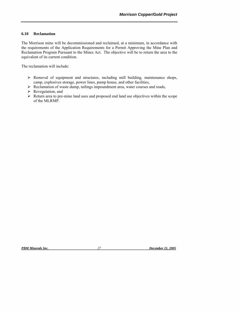
6.10 Reclamation
The Morrison mine will be decommissioned and reclaimed, at a minimum, in accordance with the requirements of the Application Requirements for a Permit Approving the Mine Plan and Reclamation Program Pursuant to the Mines Act. The objective will be to return the area to the equivalent of its current condition. The reclamation will include:
Removal of equipment and structures, including mill building, maintenance shops, camp, explosives storage, power lines, pump house, and other facilities,
Reclamation of waste dump, tailings impoundment area, water courses and roads, Revegetation, and Return area to pre-mine land uses and proposed end land use objectives within the scope
of the MLRMP.

Morrison Copper/Gold Project
PBM Minerals Inc. December 21, 2005
28
7.0 PLAN FOR FURTHER DEVELOPMENT The work plan to complete a full feasibility study on the Morrison Copper/Gold Project is outlined below. The study is expected to commence during the third quarter of 2005 and be completed by the end of the first quarter, 2007. The proposed feasibility program will consist of:
A drill program, the main objective of which is to complete delineation and geo-technical drilling at Morrison. Total amount of drilling is expected to be 3300m. This program will also include drilling for the waste disposal area and condemnation drilling.
Investigations to determine the geo-technical criteria for open pit wall design, the waste
disposal area and for building foundation design.
Update the mineral resource estimates based upon the additional drilling data and classify the resources as Measured, Indicated and Inferred according to NI 43-101 Guidelines.
Determine the pit reserves based upon the resource model and a series of pit
optimization studies to determine the reserve, which will provide the maximum net value (or cash flow). The studies will be based upon pit design data and economic criteria.
Develop all the criteria for the mine plan, including, but not limited to, open pit design,
production rate, haulage system, and equipment selection.
Design a waste disposal system that will provide sufficient capacity to deposit the waste rock and tailings produced during the life of the mine such that the facilities are secure and environmentally sound.
Complete all environmental studies to allow for permitting of the project in conjunction
with the prevailing regulations and in cooperation with the regulators. This will include fish habitat, water quantity and quality, archeology, wildlife, air quality, acid rock drainage and hydrological studies.
Develop an EA for permitting.
Develop and design a power supply system from the existing electrical grid system,
design all the electrical distribution system including instrumentation, monitoring, control systems and communication.

Morrison Copper/Gold Project
PBM Minerals Inc. December 21, 2005
29
Design all the infrastructure requirements, including but not limited to, roads, maintenance shops, warehouse, offices, explosives magazines and fuel and oil storage systems.
Prepare a concentrate marketing study.
Estimate the capital and operating costs for the various aspects of the project and
determine the costs to deliver and treat the concentrates produced by the process plant.
Complete a financial analysis of the project, including sensitivity studies.
Complete an interim report and a final feasibility at a level of confidence such that it can be used for bank financing of the project.
Complete a socio-economic study to evaluate the effect of the project on the local
communities.
Liaise with all levels of government, the Lake Babine Nation and local communities throughout the study period to ensure that everyone is aware of the project criteria and that any governmental concerns are dealt with as soon as they arise.
Set up a public consultation process that meets the needs of the Lake Babine Nation,
local communities, all levels of government and complies with the relevant regulations. It should be noted that the project criteria may change from time to time as a result of community input.
Obtain the permits for the project.

Morrison Copper/Gold Project
PBM Minerals Inc. December 21, 2005 30
8.0 WASTE MANAGEMENT FACILITY 8.1 Overview. Several locations have been investigated to determine the most likely location where waste can be deposited adjacent to the Morrison open pit. Two sites remain as possible waste disposal areas. These are Site A and Site B as shown in Figure 10-1. Site B is the preferred site, based upon the work completed to date, and is the site that was used to evaluate the project. The benefits and disadvantages for Site B are described below. 8.2 Evaluation 8.2.1 Criteria Several criteria have been used to locate and compare waste disposal areas. These are:
Location of the waste disposal site as close as is feasibly possible to the open pit. This approach results in the lowest cost for moving waste rock and provides the shortest distance for the movement of tailings, normally piped from the process plant,
A suitable area, sufficient to house all the waste rock and tailings that can be contained with the minimal construction of artificial dams or structures,
A location that has the minimal effect on the environment, and A location that can be reclaimed in such a manner that the environment is fully
protected and the system is self-sustaining.
8.2.2 Alternatives investigated Knight Piésold Ltd. (KP) were commissioned by PBM to review the alternative sites available and determine, in conjunction with the Preliminary Assessment on the Morrison Copper/Gold Project, the most appropriate location for waste disposal. The waste from the proposed open pit at Morrison consists of a number of different materials:
Waste rock that is not acid generating, referred to as NAG, Waste rock that is possibly acid generating, referred to as PAG, Coarse tailings that are considered to be non-acid generating or have a low propensity
to be acid generating, and Fine tailings that are considered to be acid generating or have a high propensity to be
acid generating. The method of disposing of the different waste types is based on the potential acid generating characteristics of the waste. The plan for the waste disposal is to use the NAG waste in any dam construction, deposit the PAG waste and the coarse tailings sub-aerially (exposed to the atmosphere) within the waste

Morrison Copper/Gold Project
PBM Minerals Inc. December 21, 2005 31
disposal facility, and deposit the fine tailings in the center of the waste disposal facility below the surface water pond. A surface water pond would be maintained within the central part of the waste disposal facility to prevent oxidation of the tailings. The result of the work to date indicates that site B is the most environmentally sound site and has the lowest construction cost. Although it is some 4 km from the open pit it the preferred site at this point of the evaluation of the waste disposal site for the Morrison Project. 8.2.3 Site B Site B is located approximately 4 km north-northeast and at an elevation of 150m above the deposit and mill site in the upper catchments/watershed. This sub-catchments drains to the north and then turns to drain westwards into Morrison Lake. The topography for Site B is gentle and subdued. This facility would be a valley impoundment where three embankments constructed to elevation of approximately 1000 meters would provide storage capacity of the site. The main embankment would be situated across the drainage course with the second located at the drainage divide. A third relatively long embankment would be constructed along the eastern side of the impoundment to provide the containment capacity. Cut offs and groundwater recovery wells may be required at each embankment. A 4.9 km access road/haul road would service the site and would include 3.3 km of 8% grade and 1.6 km of 10% grade from the deposit. In addition, a major road bridge and pipeline bridge over the adjacent drainage course would be required to cross the drainage course. The evaluation of site B indicated the following:
There appeared to be little, if any, fish habitat that would be covered by site B, Creek diversion was much simpler for site B and any make-up of water flows appear to
be easier to implement that site A, The site is sufficiently far from Morrison lake that there is little effect, if any on the
lake, The site is higher than site A and the dam heights much lower thus the aesthetics will
be more pleasing to the eye, The site appears to be one that is easier to reclaim once the mine operations have
ceased, The scheduled requirement for dam building material can be accommodated by
material from the open pit operations, eliminating any need for additional quarrying of rock,
The costs to construct the facility are estimated to be approximately 60% of the costs for site A, and
The site is some 4 km from rim of the open pit resulting in higher haulage costs for the waste rock.

Morrison Copper/Gold Project
PBM Minerals Inc. December 21, 2005 32
8.2.3.1 Conceptual Tailings Disposal Methodology Tailings produced by the Morrison operation will be stored behind a secure and fully engineered earth-fill/rock-fill embankment dam constructed across the southern outlet valley, with a northern and eastern containment embankment dams required later in the facility life. The waste disposal facility embankment dams will be designed as water retaining structures and will store co-mingled tailings and waste rock behind the dam. The dam will be developed in stages over the life of the mine to spread the capital cost out over time, and to enable the knowledge gained from the first few years of operations to be applied to the design of subsequent stages and closure. It is understood that two tailings streams are to be deposited into the waste disposal facility, the rougher scavenger tailings (RST) and cleaner scavenger tailings (CST), each having significantly different geo-technical and geo-chemical properties. Subject to confirmation by the upcoming waste characterization work that is planned, the RST will be deposited by sub-aerial methods from selected points around the perimeter of the facility to form stiff well drained beaches while the CST, which is anticipated to have a high potential for generating acid, will be deposited below the surface water pond to keep it submerged and unavailable for oxidation. The dry densities in storage and the rates of consolidation likely to be achieved by the two types of tailings are not known at this time although the sub-aqueous stored CST is likely to have a low dry density, probably in the order of 0.8 to 1.0t/m3, while the sub-aerially deposited RST is likely to have a higher dry density, probably in the order of 1.3 to 1.6t/m3. Test work will be completed in the months ahead during the planned site investigation to better estimate the densities that can be expected. An average placed dry density of 1.4t/m3 was assumed for the entire tailings mass for the conceptual level costing. 8.2.3.2 General Description The impoundment would be in a flat elevated valley at the head of the watershed draining into “Creek 54300” (“00221 BABL” system), which ultimately drains to Morrison Lake. Embankment dams would be required on the north and south sides of the valley with small saddle dams to the northwest. Either central till core dams or upstream face HDPE liners would be used as the low permeability seepage control barriers for the dams. Features of HDPE lined or till core dams at Site B are:
A main southern dam built primarily from mine waste with the northern and the saddle dams built from local borrow materials,
Downstream-developed staged construction used in all dams, Initial development to include only one starter dam (the southern dam) for
storage of 2 years tailings, From year 3 onwards the southern and northern dams would be required, with
the northwest saddle dams added later,

Morrison Copper/Gold Project
PBM Minerals Inc. December 21, 2005 33
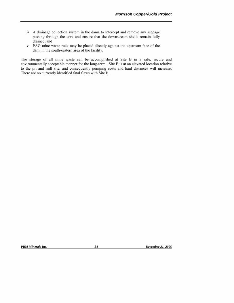
PAG mine waste placed in the south-eastern area of the facility just upstream of the southern dam for encapsulation and long-term saturated storage in the tailings,
Drainage collection systems in the dams to intercept and remove any seepage passing through the low permeability zone to ensure the downstream shells remain well drained,
Construction of a grout curtain, if needed, in the rock foundation expected in the steep valley under the east side of the southern dam,
Deposition of the RST tailings from spigot off-takes located along the crests of the dams to form stiff drained tailings beaches against the dams,
CST deposition through submerged pipes into the bottom of the surface water pond,
A reclaim barge on the surface water pond to reclaim water to the mill and remove any excess water (a water balance is required to confirm that excess water will exist),
A lined polishing pond to receive any excess water together with flows from the dam drainage and seepage systems for final cleaning, if necessary, and monitoring prior to release, and
A discharge system from the polishing pond into the bottom of Morrison Lake terminating with an outlet diffuser.
Features specific to HDPE lined dams at Site B are:
An HDPE face liner, backed by a free draining bedding material layer in each dam, The HDPE liners to be extended out into the bottom of the basin and intimately
bonded to the natural ground along the length of the embankment, to increase the length of the seepage path,
Establishment of a buffer zone between the PAG mine waste rock placed in the south-eastern portion of the facility and the liner on the face of the southern dam to prevent mine waste rock from damaging the HDPE liner, and
All materials placed in the dam to be NAG as they will be downstream of the seepage barrier (a total material volume of approximately 23.1 M cu. m. is required for all three dams).
Features specific to a central core dam at Site B are:
Central cores to be built from local borrow materials consisting of tills or other suitable material (availability to be confirmed in the planned site investigation),
The downstream shells to be constructed using NAG material, either mine waste rock or local borrow materials,
Tthe upstream shells to be constructed from PAG mine waste rock or local borrow materials,
Graded filters on the downstream sides of the cores to form a filter relationship between the cores and the downstream shells, for protection of the cores against internal erosion,
Morrison Copper/Gold Project
PBM Minerals Inc. December 21, 2005 34
A drainage collection system in the dams to intercept and remove any seepage passing through the core and ensure that the downstream shells remain fully drained, and
PAG mine waste rock may be placed directly against the upstream face of the dam, in the south-eastern area of the facility.
The storage of all mine waste can be accomplished at Site B in a safe, secure and environmentally acceptable manner for the long-term. Site B is at an elevated location relative to the pit and mill site, and consequently pumping costs and haul distances will increase. There are no currently identified fatal flaws with Site B.

Morrison Copper/Gold Project
PBM Minerals Inc. December 21, 2005 35
9.0 ENVIRONMENTAL ASSESSMENT PROGRAM
9.1 INTRODUCTION The environmental assessment studies and investigations for the Morrison Copper/Gold project will be carried out with the objective of meeting the requirements of the BC Environmental Assessment Act and the Canadian Environmental Assessment Act (if applicable). This legislation among other requirements provides for public consultation to ensure that the approval process has afforded all communities of interest a reasonable opportunity to understand the project and to communicate their concerns in a manner that they can be satisfactorily addressed. PBM has initiated a consultation process with the regulators, First Nations and local communities to assess the project’s environmental, social and economic affect upon its regional zone of influence. This includes the Lake Babine Nation (LBN) upon whose traditional territory the project will be accessed and developed. This process will continue as an integral component of the environmental assessment program to provide for public participation in the project development process and to ensure that concerns are identified and appropriately addressed. PBM is committed to the principles of sustainable development and to abiding by a management system that assures that sound operating procedures, adequate resources and effective training programs are in place to meet these principles from the pre-construction period through the operations phase to final reclamation. Appropriate engineering design criteria will also be applied to ensure that operations can comply with all applicable government legislation. It is recognized that mine life will be finite but with an effective process of engagement with the community and the acceptance of environmental and social responsibilities, a positive and enduring legacy will result from the mine development. To date, the consultative process has indicated, subject to the project being developed in a transparent manner with full consideration for the environmental, social and economic factors, that most contacts in the First Nations’ and local communities are interested in seeing the project being placed into production. Selected environmental base line studies have also commenced for the Morrison Copper/Gold Project. These studies include fish and fish habitat, water quality and hydrology, flora and fauna and acid rock drainage. 9.2 ENVIRONMENTAL ASSESSMENT (EA) PROCESS The constitutional division of power between the Federal and Provincial governments gives British Columbia responsibility for the development of its mineral resources. However, the Federal government retains an integral role in the project environmental approval process

Morrison Copper/Gold Project
PBM Minerals Inc. December 21, 2005 36
through its responsibility for fisheries, navigable waters, explosives storage and use, and environmental protection. Through the past several years of exploration activity, PBM has maintained on going communications with both levels of government to inform them of their activities and to develop a mutual awareness of the project scope and the sequence of activities leading to its feasibility evaluation and environmental assessment. In October 2002, PBM met with the Northwest Mine Development Review Committee in Smithers. Chaired by Wally Bergen of the BC Ministry of Energy and Mines (MEM), the meeting included representatives of the BC Environmental Assessment Office (BCEAO), the Ministry of Water, Land and Air Protection (MWLAP), the Ministry of Forests, the Canadian Environmental Assessment Agency (CEAA) and Environment Canada (EC). Members of the Lake Babine Nation and councilors from the Village of Granisle also attended. At the meeting, PBM outlined its project plans and development schedule, and the agency representatives described the process for the pre-application stage of the Environmental Assessment Process. Ongoing consultations have been held with various provincial and federal agencies. These included meetings with the BCEAO and the MEM in Victoria in June 2003. A courtesy meeting was also held in June 2003 with the Canadian Environmental Assessment Agency, Environment Canada and Fisheries and Oceans Canada in Vancouver. In July 2003, a meeting was held with the regional managers of MWLAP and MEM. The purpose was to keep the authorities informed that PBM was actively advancing its preparatory activities to formally enter the Environmental Assessment Process. The Project Description was first submitted to the BC Environmental Assessment Office in September 2003. This document was posted by the BCEAO on their website (www.eao.bc.ca). On September 30, 2003 the BCEAO issued a Section 10 Order under the BCEA Act that declared the project to be a reviewable project pursuant to the BC Reviewable Projects Regulation. Following this on October 20, 2003, a multi-agency meeting chaired by the BCEAO (Bob Hart) was held in Smithers. Along with the BCEAO and PBM, representatives of other Provincial and Federal agencies and representatives of the First Nations also attended. A planned site visit the following day was postponed pending the resolution of procedural requirements requested by the Nedo’at (Old Fort) Band. The visit to the Morrison property by the Provincial and Federal agencies is an essential part of the process. It allows interested agencies to determine the site-specific issues of concern under their enabling legislation that must be addressed by the environmental assessment program investigations. This visit was completed on July 6, 2004 and included representatives of the First Nations as well as the BCEAO, MEM, MWLAP, BC Ministry of Sustainable Resource Management (MSRM), Environment Canada, and Fisheries and Oceans Canada (DFO). The Canadian Environmental Assessment Act is the Federal law that requires Federal decision makers (i.e., "responsible authorities") to determine whether the anticipated environmental effects of proposed projects would trigger their involvement in the assessment process under
Morrison Copper/Gold Project
PBM Minerals Inc. December 21, 2005 37
the Fisheries Act, the Navigable Waters Protection Act and the Explosives Act. PBM is committed to on going communications with CEAA and the other Federal authorities to enable them to determine their decision-making responsibility and any trigger criteria that would require their participation in the assessment process. The BCEAO takes a facilitating role to coordinate the communication of agency interest and participation. This responsibility is provided by their enabling Act and by the Canada – British Columbia Agreement on Environmental Assessment Cooperation (2004) (the “harmonization agreement”) with the Federal authorities. With the completion of the site visit by the various Provincial and Federal agencies and PBM’s response to the agencies’ requests for additional information, PBM anticipates the BCEAO decision to issue its Section 11 Order under the BCEA Act. This order defines the environmental process and scope. It requires the preparation of draft Terms of Reference for the project environmental assessment studies and other investigations necessary to support an Application for an Environmental Assessment Certificate by the BCEAO and a Ministers’ Decision. PBM has prepared a draft Terms of Reference in anticipation of a Section 11 Order. The final Terms of Reference will be developed in consultation with the First Nations, interested agencies, communities, and other parties for the approval by the BCEAO. The approved Terms of Reference will be used to define the scope of work of specialty consultants to undertake issue-specific investigations. The Federal CEA Act similarly requires meaningful public participation in conducting environmental assessments to give interested parties the opportunity to put forward their knowledge and views on the project.

Morrison Copper/Gold Project
PBM Minerals Inc. December 21, 2005 38
9.2.1 Regulatory Framework The Morrison Copper/Gold Project will be a reviewable project in accordance with the British Columbia Environmental Assessment Act (BCEAA) Reviewable Projects Regulation, Part 3-Mine Projects, Table 6, Mineral Mines as “a new mine facility that, during operation, will have a production capacity greater than 75,000 tonnes/year of mineral ore.” In addition to obtaining the BC Environmental Assessment Certificate under the BCEAA, other permits and approvals will be required for the construction and operation of the Morrison mine. The following list is not exhaustive but identifies most of the legislation that is expected to apply: 9.2.1.1 Provincial
Mines Act Permit, pursuant to Section 10 of the BC Mines Act (EMPR), (including the Health, Safety and Reclamation Code and the Mineral Exploration Code)
Permit pursuant to the Mining Right of Way Act (EMPR), Alteration Permit under Section 12 of the Heritage Conservation Act (TSA), Water Licenses, pursuant to the Water Act (for storage and diversion of water
(MWLAP), Notifications of in-stream works, pursuant to Section 9 of the Water Act
(MWLAP), Effluent Permit, Refuse Permit, Air Permit, Fuel Storage Permit and Special
Waste Permit pursuant to the Environmental Management Act (MWLAP), Permit pursuant to the Wildlife, Burning Permit, pursuant to the Forest and Range Practices Act (MOF), License to Cut, pursuant to the Forest Act (MOF), Special Use Permit, pursuant to the Forest Practices Code of British Columbia
Act (MOF), License of Occupation, pursuant to the Lands Act (for power line right of way,
quarries, camps and staging areas) (MWLAP), Permits pursuant to the Health Act and Food Premise Regulation, Industrial
Camps Health Regulation, Sanitary Regulations and Sewage Disposal Regulation (NHA), and
Permits pursuant to the Drinking Water Protection Act (NHA). 9.2.1.2 Federal Under the Canadian Environmental Assessment Act (CEAA), the responsible authorities of the Federal Government will determine their involvement with respect to the anticipated environmental effects of the project that would trigger their involvement in the assessment process under the Fisheries Act, the Navigable Waters Protection Act and the Explosives Act. However, the Morrison Copper/Gold Project is not expected to trigger the CEAA for the following reasons:

Morrison Copper/Gold Project
PBM Minerals Inc. December 21, 2005 39
Fisheries Act – no authorization is expected to be required. o Habitat – the entire development area of the mine is located upstream of
any known fish habitat. o Flows- There are several lakes and watercourses adjacent to the
proposed mining area that can be used as a source of both potable and process water. The majority of the process water will re-circulated from the tailing containment area to minimize the quantity of make-up water required for process plant operation. The final water balance for the site is being developed (a preliminary water balance is included within this report) but release of water that meets effluent release guidelines is expected to occur on a periodic basis.
o Water Quality – PBM will meet all Water Quality Objectives approved by the B.C. Ministry of Water, Land and Air Protection, to ensure the protection of the aquatic environment including fish.
Navigable Waters Protection Act – no navigable waters will be affected. Explosives Act – a contractor from a licensed manufacturing facility operated
offsite will supply Explosives. 9.3 Public Consultation Both the BC Environmental Assessment Act and the Canadian Environmental Assessment Act contain provisions for public consultation as a component of the environmental assessment process. As a part of its ongoing efforts to develop and maintain open communications, PBM will direct a program of public consultation to meet the specific requirements of the two Acts. Results of public consultation efforts will be documented for presentation in the environmental assessment report. 9.3.1 First Nations Consultation and Participation The Morrison property is located on the traditional territory of the Lake Babine Nation. There are four LBN communities; Fort Babine, Nedo’ats (Old Fort), Tachet and at Burns Lake which is outside LBN traditional territory within the traditional territory of the Wet’suwet’en Nation. Indian and Northern Affairs Canada census data for 2005 gives a LBN population of 2178, of whom 1414 live on (own or other) reserve and 764 live off reserve (http://sdiprod2.inac.gc.ca/FNProfiles/FNProfiles_GeneralInformation.asp?BAND_NUMBER=607&BAND_NAME=Lake+Babine+Nation). PBM has been working on the traditional territory of the LBN since the early 1990’s on both on the Hearne Hill and the Morrison properties. During this time the company has actively communicated with members in all communities of the LBN and employed members of the communities on its exploration projects. The boundary between the traditional territories of Nedo’ats and Fort Babine cuts across the claim area with the boundary line just south of the proposed project area – Nedo’ats to the south and Fort Babine to the north. PBM continues to seek advice from both Nedo’ats and Fort Babine on how PBM can involve both communities
Comment [RGK1]: This statement is speculative and could be misunderstood the Federal regulators. Although fisheries habitat disruption is expected to be minimal, we cannot say without additional design development whether the stream discharging from Site B and its downstream spawning habitat won’t be affected. Note that Red Chris was “triggered” according to their VP Environment, Peter Campbell – first by DFO but also by NRCan who have Explosives Act responsibility.

Morrison Copper/Gold Project
PBM Minerals Inc. December 21, 2005 40
and the broader LBN in a way that is culturally appropriate while following traditional protocols. PBM believes that the development and maintenance of ongoing communications and business linkages with the LBN is essential. It is proposed that PBM and representatives of the LBN will participate in project planning from the onset to develop mutual understanding, respect, trust and a good working relationship to the benefit of both parties. This strategy is intended to:
Provide employment that leads to self-reliance and respect. This includes training programs,
Provide contractual opportunities, Involve LBN individuals, at the earliest opportunity, in baseline studies, the EA
process, permitting, ongoing life-of-mine joint monitoring and other planning and communications activities, and
Incorporate traditional knowledge into project planning activities. The components of this strategy will enhance the capacity of the LBN to participate meaningfully in the Morrison Copper/Gold Project, and other opportunities that present themselves.

Morrison Copper/Gold Project
PBM Minerals Inc. December 21, 2005 41
10.0 LAND USE The Morrison Copper/Gold Project is located within the Morice Land and Resource Management Plan (LRMP) area. The Morice LRMP encompasses 1,509,203 hectares in west-central British Columbia including 36,455 hectares of private land that will be excluded from the LRMP. The Morrison property is located in the northern end of the LRMP area. The proposed mine operation site is situated on Crown land. Current land uses in the vicinity of the Morrison property relate primarily to forestry activity with Canfor having tree farm licenses at the project site and Houston Forest Products operating nearby to the west of Morrison Creek. Much of the mine site development area has been logged and to a certain extent re-planted. Other activity within the surrounding region includes hunting, trapping, guide outfitting, backcountry wilderness tourism and recreation. Mineral exploration has been ongoing on and around the region for decades and both the Granisle and Bell Copper mines operated during the period from 1966 to 1992. The environmental assessment report will provide information on the extent of other land uses in the area and identify the potential for mine development and operations to affect other users. 10.1 ENVIRONMENTAL SETTING AND EFFECTS ASSESSMENT The Morrison property is located 65 km north east of Smithers and it covers approximately 9,950 hectares. Located on the east side of Morrison Lake, it is in the sub-boreal spruce biogeoclimatic zone. The topography is characterized as undulating and rolling plateaus rising to the east to the ridge dominated by Hearne Hill at an elevation of 1350 metres. Drainage from the Hearne Hill and Morrison deposit areas is contained within seven sub-basins. From south to north, drainages 1, 2 and 3 flow into Morrison Creek downstream of Morrison Lake. Drainages 4, 5, 6 and 7 drain directly to Morrison Lake. Figure 10-1 The Morrison Creek Watershed is one of the four main sub-basins of the Babine Lake system. Lakes are an important feature of the watershed and Morrison Lake is the most predominant with a surface area of 1325 ha and a maximum depth of 60 m (FISS database). Other lakes include Tahlo (152 ha) and Haul (304 ha) lakes as well as a dozen smaller lakes generally less than 70 ha in area, including several in the vicinity of the proposed mine development area (Bustard, 2004) The Babine/ Morrison lakes system is a salmon spawning and rearing area of high value and importance. Babine Lake is the largest natural lake in BC and is one of the major sockeye salmon producers in the Province, accounting for 90 percent of the Skeena River sockeye run. (Bustard, 2004)

Morrison Copper/Gold Project
PBM Minerals Inc. December 21, 2005 42
Figure 10-1

Morrison Copper/Gold Project
PBM Minerals Inc. December 21, 2005 43
10.1.1 Environmental Issues PBM have responsibility for safeguarding the air, land and water, and investigations are planned or have been initiated to characterize each of these as described below. The priority environmental concern is water due to the proximity of the Morrison Copper/Gold Project to the Morrison/Babine lake system. From discussions with the Federal and Provincial agencies, the LBN and others, PBM have identified fisheries and fish habitat, surface and ground water, and acid rock drainage (ARD) potential as the principal project environmental management issues. Without discounting other areas of environmental and social responsibility, water management is identified as essential for the assurance of acceptable containment, control, monitoring and reporting of effluent, seepage and surface water runoff. Engineering features will be integrated into the design to maximize the effectiveness of water management and to minimize fresh water consumption. To characterize the seasonal effects pertaining to these issues or to coordinate assessment requirements with associated exploration program activity, baseline data collection can require an extended period (12 months or more) for development. In consultation with the authorities of interest, specific field programs have been carried out with specialist consultant participation in advance of obtaining the final Terms of Reference. The information from these investigations enables the development of engineering design concepts that provide for the prevention and mitigation features to safeguard the environment 10.1.2 Surface Water Hydrology and Quality McElhanney Consulting Services has carried out stream flow monitoring programs on behalf of PBM since May 2001 with the installation of staff and crest gauges at six stations. Data collection was not continuous. To develop baseline data for water management pertaining to mine development and fisheries habitat protection, five automated pressure recording transducers were installed and have been operating since October 2004 in the principal streams transecting the mine site and the two tailing/waste rock management facility site alternatives A and B. Site hydrological data will be correlated to data available from regional hydrological stations to obtain estimates of stream flow over a variety of return periods. This information will be applied in the design of the tailings/waste rock management facility and in particular to provide for minimum acceptable flows on streams inhabited by fish. Since 1997, McElhanney Consulting Services has also carried out water quality monitoring programs on behalf of PBM. Data collection was not continuous through 2003. A field sampling and laboratory analytical program for surface water quality baseline data collection was re-commenced with twelve monthly samples collected and analyzed through the period May 2004 to June 2005 (samples were not available for December 2004 due to ice conditions). The program was initiated in consultation with the BC Ministry of Environment (BCMOE) Regional Office (formerly MWLAP) and in general accordance with Environment Canada requirements. Since monitoring program commencement, a database of physical and chemical parameters have been collected from eight stations (plus a control station at Morrison Creek) for streams draining the mine development area and the two tailing/waste rock management
Comment [RGK2]: This is an expected permit and federal MMER requirement, I believe it gives credibility to proactively acknowledge that the company will inform.
Comment [RGK3]: Correctly identified?

Morrison Copper/Gold Project
PBM Minerals Inc. December 21, 2005 44
facility site alternatives A and B. Parameters include total and dissolved metals, major anions (SO4ֿ2, Clֿ, NO3ֿ, etc.), hydrocarbons, pH, temperature, conductivity, dissolved oxygen, etc. It has been noted that some parameters naturally exceed BC Water Quality Criteria. This will be reviewed with the regulatory agencies during forthcoming discussions to determine the on-going program scope and requirements. A detailed compilation and analysis of existing baseline water quality data will be used in conjunction with a project water balance and hydrological data to complete mass loading models for an assessment of potential discharge affects from the operation including any surface runoff, seepage or controlled effluent release. 10.1.3 Ground Water Hydrogeology and Quality Information from these programs will be used to provide a detailed analysis of the groundwater regime in the vicinity of project area and to assess the potential affects associated with mine development, operation and closure. Initial water level measurement and falling head tests were conducted in coordination with the 2003-drilling program. Piezometer installation and exploration drill hole measurements to determine the existing subsurface water level were commenced. Further work is proposed to install several standpipe piezometers in drill holes during the 2005 drilling program. Since October 2004, ground water samples have been collected for analysis from a single artesian mine deposit area exploration drill hole. To develop the baseline physical and chemical character of the ground water within the mine development area, it is nominally expected that four monitoring wells will be required near the open pit and tailing/waste rock management facility site B. The actual number of wells will be determined upon review of the site drilling and geotechnical evaluation. Monitoring wells will be used for water level measurements, water quality sampling and response tests as approved by the regulators. 10.1.4 Acid Rock Drainage / Metal Leaching Chalcopyrite and pyrite are the main sulphides at the Morrison deposit with minor to moderate amounts of bornite in several places within the copper zone. Surrounding the copper core is a pyrite halo. All rock sampled at Morrison contains varying quantities of pyrite, locally in excess of 1%. Minor calcite veining and carbonate alteration are associated with the copper-gold mineralization, and the presence of these minerals will neutralize the acid generation to some extent. The extent of this ARD potential and the strategies for its management must be further investigated. Minesite Drainage Assessment Group has initiated an ARD assessment program on behalf of PBM. A total of 140 drill core samples have been tested by standard acid-base accounting (ABA) test methods and to produce metal content analyses by ICP and XRF methods. An initial 24 sample set was selected from drill core obtained from the 2003 exploration program. Samples were obtained from the northwest and east-central perimeters of the deposit. The remaining 116 samples were collected from drill core from earlier exploration programs stored
Comment [RGK4]: I haven’t been involved directly with the current field geotechnical work. Nor has Rod Smith, the hydrogeologist at Water Management Consultants – it needs to be confirmed whether this statement is correct or needs to be revised.

Morrison Copper/Gold Project
PBM Minerals Inc. December 21, 2005 45
at the project site. Results have indicated a varying range of ARD potential from high probability to generate acidity, to uncertain or with some acid neutralizing capacity. Based upon the available sample set collected to date and the B.C. provincial assessment guidelines, it is conservatively assumed that about 58% of the samples would be acid generating. Extensive additional ABA and kinetic testing and analysis will be required to understand the potential for metal transport and ARD generation from the deposit waste rock and tailings. Of particular importance will be ARD sampling for all major rock types, mineralogy, etc. by ore, waste rock and overburden categories determining their location and spatial distribution within the ultimate open pit limits. The results of the ML/ARD characterization program will be used to develop the operating management strategy for tailing and waste rock handling and storage, and for closure planning. It will also provide guidance for sourcing of rock and aggregate for construction. 10.1.5 Fisheries and Aquatic Species The Federal Fisheries Act provides for the protection of fish habitat and is very specific with respect to the habitat alteration, disruption and destruction (HADD) that can be authorized by DFO. Thorough assessment of fishery and other aquatic resources (benthic species, periphytons) and their physical and biological habitat is essential to determining the involvement of DFO and the extent of mitigation or compensation that may be required for HADD. A background compilation of fisheries information for the Morrison watershed was completed by David Bustard & Associates Ltd. and submitted to PBM, and DFO and the BCMOE Regional Office in 2004. This background review in conjunction with a meeting with these agencies’ review staff in the spring of 2004 identified a number of areas that needed additional information to help them to assess the project implications. It enabled the development of a field program to provide an assessment of fish utilization and habitat in the vicinity of the mine site, and a basis to determine the potential for mine development, operations and closure to affect fish and fish habitat. This program was initiated in the summer of 2004 but was suspended during 2005. Pending the review of the 2004 program results with the regulatory agency review staff, it is anticipated that future field studies will continue to focus on information collection to identify and address potential project impact. These studies could include:
Rainbow trout spawning studies in streams in the mine footprint, Juvenile fish studies in the mine footprint streams that, depending on mine
design, could be required to quantify any “no net loss” target estimates, and Salmon spawning work to investigate shoreline spawning in the vicinity of the
key mine footprint stream confluence areas on Morrison Lake where salmon spawning was observed in 2004.
Comment [RGK5]: Dave Bustard advised in his July 2005 progress report that “This report is in draft format with a small amount of map work and a summary conclusion section and information sources to be completed. This work has been put on hold since late June.” I am awaiting his feedback to advise what is required to allow him to complete this report.

Morrison Copper/Gold Project
PBM Minerals Inc. December 21, 2005 46
Should it be determined that mine development, operation and/or closure will result in an unavoidable loss of fish habitat; a fish habitat compensation plan may be required. Such a plan would require additional fieldwork to identify appropriate compensation measures. Additional field investigations will be conducted to develop baseline aquatic resource data on species, population and distribution of benthic invertebrates, periphyton, phytoplankton and zooplankton. 10.1.6 Lake and Stream Sediments To determine the baseline physical and chemical character of water body sediments around the mine development area, sediments will be collected from surface water courses and Morrison Lake in areas susceptible to sediment loading associated with mine development and operations. 10.1.7 Flora and Fauna Studies & Terrestrial Ecosystem Mapping In consultation with BCMOE Regional Office, a program was designed by Ardea Biological Consulting to provide for the compilation and assessment of flora and fauna including rare and endangered species. Initial reconnaissance commenced in August 2004. Wildlife habitat surveys were continued in November 2004 and March 2005. These surveys will be required to continue on a seasonal basis. Particular attention will be given to any species listed in the Species at Risk Act. A program of terrestrial mapping was initiated in 2004 to document the vegetation by species and location. Recent Predictive Ecosystem Mapping (PEM) provides information on wildlife use and habitat suitability/capability based on for the Morice and Lakes Innovative Forest Practices Agreements (IFPA). The mapping indicates potential high value grizzly bear, moose, amphibians, furbearers (e.g. marten, fisher), and waterfowl habitats in the area. There is also the potential for waterfowl and amphibian habitats in the proposed project area that may require evaluation. Presence and habitat use by other species such as nesting raptors (e.g. eagles, osprey, hawks etc.), small mammals, predators, etc. will be noted during the habitat assessments. Field observation at the project site has indicated some variation from the regional PEM database but it is expected that this can be addressed to meet the BCMOE needs with species-specific (e.g., moose and grizzly bear) habitat suitability mapping. The PEM products and air-photos will continue to be used to plan sampling and mapping of rare plants and ecosystems within the project area. Sampling will be carried out in conjunction with other planned wildlife habitat assessment work. Baseline information is expected to be required on the ambient concentrations of trace elements in the upland and wetland plants used by ungulates and bears in the vicinity of the proposed tailing areas. It will provide baseline data and will allow future comparisons during operations and closure for assessing the effects of uptake of metals in vegetation on wildlife and human health. Vegetation samples were collected for this purpose during 2004.

Morrison Copper/Gold Project
PBM Minerals Inc. December 21, 2005 47
The results of the assessments, mapping and potential mitigation measures will be reported in a detailed compilation and assessment of the baseline wildlife information. This will be used to develop mitigation measures for potential development and operational affects to wildlife and wildlife habitat and to provide for the return to productive wildlife habitat upon closure. Species at Risk, as defined in the Species at Risk Act, in the vicinity of the project will be identified and the potential for the project to affect on listed species and their habitat. 10.1.8 Surficial Geology & Soils In coordination with site engineering investigations, a survey will be conducted to develop a detailed description of surficial geology in the vicinity of the property including glacial, colluvial, alluvial and fluvial landforms and features. Of particular interest will be the identification of basal tills for dam construction. Soils mapping and sampling for soils recovery and reclamation will be carried out in detail on the proposed pit and infrastructure areas, and at a reconnaissance level within the surrounding study area. Removal and storage of surface soils will be planned for site reclamation purposes. The availability of local limestone will be important as part of an ARD control strategy. 10.1.9 Seismicity & Terrain Stability For project design purposes, an analysis of regional seismicity and earthquake potential based on data generated by the Pacific Geosciences Centre. Seismic data will be incorporated into designs for the tailings impoundment dams and other structures. A terrain stability analysis for the property and infrastructure corridors will be conducted including the potential for landslides and avalanches. Information generated from the terrain stability analyses will be utilized in assessing the location and design of tailing/waste rock management facility, process buildings, and other structures. 10.1.10 Climate and Air Quality The development of a local climate database is essential for engineering design of tailing / waste rock management facility dams, process and other buildings and water management control structures. There has been no site meteorological data collection to date. The BC Forest Service maintains a meteorological station adjacent to the PBM exploration camp and approximately 5 km from the project site. This station collects wind speed and direction data, temperature and relative humidity on a daily basis. This data is made available by subscription as well as data from other BCFS north-central region stations. Atmospheric Environment Service meteorological stations should also provide regional data for correlation with site area data to enable the prediction for mine site maximum and minimum annual precipitation and storm events for various return periods. This data will be used for design purposes for the tailing and waste rock storage facilities and other structures, for water balance calculations and impact predictions through the operating and post-operating periods.

Morrison Copper/Gold Project
PBM Minerals Inc. December 21, 2005 48
There has been no air quality monitoring to date. Logging activity has occurred on an intermittent basis but otherwise the affect upon air quality is minimal and it is essentially pristine. It is anticipated that standard modeling techniques will be applied to predict the potential air quality impact associated with the mine development and operation, and to determine appropriate mitigation strategies for both mobile and point sources. 10.1.11 Noise While no baseline noise monitoring has been conducted to date, the site is located in a remote location with limited potential for noise affects associated with anthropogenic sources. With the exception of periodic forestry activity, baseline noise levels are considered to be essentially natural. Standard modeling techniques will be applied taking into account topography and weather conditions for the area, and experience from similar operations to predict the potential for noise affects on wildlife and the public associated with the operation and to design appropriate mitigation measures. 10.1.12 Archaeology, Traditional & Cultural Use The Babine Lake region is known to have a rich heritage that includes the culture of the Lake Babine Nation that preceded the arrival of European settlers. After the Europeans’ arrival, their activity and development contributed further to the heritage of the region. No archaeological or cultural use assessment has been conducted in the immediate vicinity of the property. Such an assessment is planned and will be compiled and presented as a part of the environmental assessment report. The assessment of cultural and heritage values within the area of activity of the Morrison Copper/Gold Project (for example, culturally-modified trees) will be determined by literature review and consultation with the LBN, local museums and other sources. Field investigations will be planned to further document any evidence of artifacts or other indications of heritage and cultural significance. 10.1.13 Socio-Economic Assessment Through job creation (direct and indirect), purchasing, training programs and transferable skills, contracting opportunities and tax payments, the Morrison Copper/Gold Project has the potential to create significant positive economic benefits for the Bulkley-Nechako Region and beyond. At the same time, the mine development has the potential to affect local and regional resources through increased demand on social services such as police, health care, housing and education. Social affects at the community and family level also have the potential to occur as a result of increased disposable income, lifestyle changes and work-associated demands. An assessment will be made of the potential economic and social affects associated with mine development based on regional demographics and community profiles. The assessment will include and be based on factors such as estimates of employment income, taxation levels, and purchased goods and services, as well as expected numbers of local versus non-resident employees, increased population resulting from in-migration of employees, shift rotation schedules, housing and accommodation.

Morrison Copper/Gold Project
PBM Minerals Inc. December 21, 2005 49
The potential social affects upon the LBN at the local level will be given particular consideration in the context of the commitment that PBM has to engaging and providing for the participation of the LBN. The potential social impacts and benefits of the project are being addressed with the LBN and will continue to be throughout the life of the mine. 10.1.14 Public Health & Safety The environmental assessment report will include an examination of the potential affects of all phases of the proposed project (construction, operation, maintenance, decommissioning) on public health and safety with consideration of relevant determinants of health. Included in this assessment will be descriptions of the general public health setting and characteristics influenced by such factors as public utility services (water, waste, etc.), emergency services, noise, and air quality. The application will assess and evaluate the potential project affects upon the health and safety of employees, their families and local communities (including First Nations), and describe mitigation measures for any possible effects to human heath and safety.