paleoclimatic reconstruction and archaeological investigations
TRANSCRIPT

Paleoclimatic Reconstruction and Archaeological Investigations
at Xcoch and the Puuc Region of Yucatan, Mexico in 2010:
Exploratory Research into Arctic Climate Change and
Maya Culture Processes
Michael P. Smyth
Foundation for Americas Research, Inc.
Ezra Zubrow
State University of New York at Buffalo
David Ortegón Zapata
Instituto Nacional de Antropología e Historia
Nicholas P. Dunning
Eric M. Weaver
University of Cincinnati
Philip van Beynen
University of South Florida
2010 Preliminary Report for the
EArly–Concept Grants for Exploratory Research
(EAGER, 0940183)
National Science Foundation
Arctic Social Sciences Program
Washington, D.C.

1
This report presents the results of the second year of research of an Early Concept Grant (NSF
0940183) for Exploratory Research (EAGER) that took place at the ancient Maya center of
Xcoch and the Puuc region of Yucatan, Mexico in 2010. How data from the Puuc region relate to
the nature of hydraulic systems and patterns of cyclical drought is being investigated and
promises to shed new light on the processes of Maya response to cultural-environmental
interplay and the rise and demise of early complex societies in the Northern Maya Lowlands.
A program of multidisciplinary research at the Maya center of Xcoch in the Puuc region of
Yucatan, Mexico began in 2006 and remains ongoing. This work is focused on determining if
the site had significant occupation during the Preclassic period, the size and density of settlement
through Late Classic times, and the investigation of a deep water cave below the monumental
center as well as numerous water control features distributed across the settlement. In 2009, the
project initiated a study designed to begin reconstructing climate change and the human
responses over the past 3000 years, especially emphasizing the phenomena associated with so-
called Classic Maya collapse (800-900 AD). This time period is especially relevant to global
climate researchers because it coincides with the Medieval Warm Period (AD 800-1300), when
climatic conditions enabled Norse peoples to explore and colonize the North Atlantic Islands and
reach the shores of America (Dugmore et al. 2007; McGovern et al. 2007). How climate change
affected processes of cultural development and decline in the Maya Lowlands has the potential to
inform us today regarding the far-reaching cultural-environmental impact of global climate
change.
The results through 2010 continue to show that Xcoch was a large Prehispanic Maya center
distinguished by a long occupation dating back to the Middle Preclassic period (~800-400 BC),
or earlier, and peaking in the Late Classic period (600-800 AD) before general abandonment of
the site, though the deep water cave continued to be visited up until modern times. Contextual
and chronometrical archaeological data so far suggest that there were at least two periods of
intense construction activity that correspond to contemporaneous episodes of cyclical drought.
Based on climatic data from Lake Chichencanab, Yucatan, Belize, and elsewhere in the
Caribbean Basin (e.g.,Hodell et al. 2001; Haug et al. 2003; Webster et al. 2007; Moyes et al.
2009), one series of drought cycles may have occurred near the end of the Preclassic period
around the 2nd century AD, or about the same time that massive efforts were made at Xcoch for
rainwater capture in the form of hydraulic systems such as aguadas (water ponds), massive
catchment surfaces, drainage canals, and chultuns (underground water cisterns). Excavations
show that these efforts may have been in vain because stratigraphic evidence for a hiatus in
occupation associated with the end of the Preclassic indicates that many site areas were
abandoned at this time.
Near the end of the Early Classic period (~500 AD), Xcoch was reoccupied and settlement
slowly began to build in a crescendo-like fashion to reach a maximum in the Late Classic.
However, there is again evidence for another series of drought cycles (Hodell et al. 2001;
Webster et al. 2007; Wahl et al. 2007; Media-Elizade et al. 2010) ) that may have pressured
Xcoch populations to intensify water management by resurrecting and expanding old water
control systems or by constructing new ones for capturing rainwater. Evidently, these efforts

2
were again insufficient because the site shows settlement abandonment, perhaps abruptly, by the
Terminal Classic period (~800 AD). Though clearly suggestive, previous climate change data in
the Yucatan has been too course-grained and non-site specific for rigorous cultural interpretation
at the site level. Much more localized and comprehensive paleoclimate and settlement data are
required to properly assess the relationships between drought cycles and human responses at
Xcoch and the Puuc region.
This report details the current settlement pattern research, including surface collection survey
and architectural mapping, and a program of test excavation, ceramic analysis, and radiocarbon
dating through 2010, and discusses the research into water management practices such as the
aguadas at Xcoch as well as the related cave investigations and speleothem analyses carried out
at the Xcoch and Vaca Perdida caves. These studies indicate that the site of Xcoch and vicinity
were occupied at the beginning of Maya settlement in northern Yucatan and that the Puuc region
was affected in the past by numerous drought cycles that had significant impact on human
adaptation and culture process.
Settlement Survey and Surface Collections
Surface collection survey at Xcoch continued in 2010. Site-scale systematic interval sampling of
the surface landscape was a major component of field research completed at the Puuc region
sites of Sayil and Chac (II) approximately 20 km south of Xcoch. The purpose of such work was
to document urban phenomenon and investigate human adaptations in the challenging tropical
environment of the Puuc Hills and can provide important comparative region-wide variability in
responses by the Maya to severe climate change in the prehispanic past.
The Xcoch Project to date has surface collected an area of about 100 hectares radiating out from
the site center of Xcoch (Figure 1), including more than 30 hectares in 2010. The surface survey
so far is composed of 857 3x3 m units spaced at intervals of 25 m of which 304 were collected
and recorded in 2010. Within the central area of Xcoch, most architectural features were mapped
at a scale to 1:200. The site-scale survey is anchored to a base line datum at N5000 E5000 near
where the municipal border (mensura) runs east-west separating the municipal lands of Santa
Elena from Ticul. From this starting point, main north-south brechas (trails) were opened to
N6000 and south to N4700. The survey in 2010 has reached west to E4600 and to east to E5400
between N5400 and N4800. With the aid of a total-station EDM (Electronic Distance Measuring
Theodolite)) and GPS receiver, main breaches north-south were opened each 100-mts with 3x3
m collection units placed every 25 m.
Significant architectural and ceramic surface remains were found throughout the area
around the central groups at Xcoch, including the dense settlement zone known as the Elite
District east of the Great Pyramid and Grand Platform. Also, three groups south of the Gruta
Xcoch and three groups to the west, including massive habitation platforms, an immense aguada
(La Gondola), and the Chac-Na group. Though the exact settlement limits of Xcoch have not
been determined, there is evidence for settlement radiating outwards in all directions more than 1
km, including pyramid groups, aguada features, and causeways both long and short.

3
Figure 1: Settlement and topographic map of Xcoch following the 2010 field season.
The name “Cave Pyramid” was given to a prominent pyramid temple that sits immediately above
the sinkhole (Xcoch Grotto) in which the entrance to Xcoch cave is located (Figure 1). The Cave
Pyramid sits on the southwest edge of Xcoch Plaza, the apparent central point of the ancient
community. There are at least two causeways that converge near the Pyramid to the west and
southeast. The southeast causeway travels almost 1 km before arriving at a natural hill that
supports three structures forming a triadic group placed upon an expansive leveling platform:
two pyramids of the megalithic style without vaulted summit buildings and a vaulted range
structure to the east. Less than 1 km to the south of this group are two aguadas (one is “Xcoch
South Aguada 1” and the other is a deep depression over which a paved farm road passes) within

4
the mechanized parcels of the municipality of Santa Elena. From previous reconnaissance, we
know that there are other pyramid groups and substantial settlement 1 km to the east of the Great
Pyramid, other groups with substantial architecture in the intermediate zone, and habitation
structures to the southeast. Eight hundred meters north of the Great Pyramid are numerous
settlement groups including a number with pyramids at least one (Old Pyramid Group below) of
which is dated to the Preclassic period.
Settlement at Xcoch is much more dense and extensive than originally anticipated when the
project began. It is now estimated that Xcoch may cover 6 km², though this projection may be
conservative because satellite imagery suggest that there are substantial structures beyond the
current northern and eastern survey limits. The survey indicates that settlement is continuous to
the north and could include another aguada 1.5 km to the northeast (Dunning 1992). Xcoch
extends 1 km to the west where a shallow aguada was identified in 2010 and more than 1 km to
the east because there is no evidence of any settlement drop-off beyond the areas of preliminary
reconnaissance. This same kind of settlement pattern continues to the south indicating that Xcoch
extends another 2 km in this direction. In fact, numerous habitation structures were located in
2010 within the newly cleared municipal parcels 2.3 km southeast of the Great Pyramid, which is
clearly visible in the distance. Therefore, several more seasons of surface collection and
settlement mapping survey are required to completely document the site.
Architectural Mapping and Site Description
The site of Xcoch is best known for a deep water cave, a tall megalithic pyramid, and a giant
platform covering about 1 hectare that together stand more than 42 m above the ground surface.
The survey work revealed that the Great Pyramid is the highest point of a massive multi-level
acropolis incorporating at least 7 architectural groups covering more than 10 hectares,
representing one of the largest architecturally integrated constructions in the Puuc region (Figure
1). Much of the acropolis is constructed in the early megalithic style, characterized by large
shaped boulders with abundant chinking stones, and believed to be an indicator of Preclassic to
Early Classic occupation. On the south side of the Grand Platform leading to the Great Pyramid
are two megalithic staircases with treads and risers measuring up to 2 m in length. The central
megalithic staircase is virtually identical to one recently consolidated at Xocnaceh, a relatively
small site approximately 20 km to the east of Xcoch centered by an enormous Preclassic
platform (Gallareta Negrón and Ringle 2004; Bey 2006). Atop the Megalithic Staircase at Xcoch
are three stone buildings, one or more showing and the remains of early-style vaulted roofs. The
Great Pyramid of Xcoch towers over the north end of the Grand Platform. Lower sections of this
enormous terraced pyramid show megalithic characteristics, but the uppermost reaches are
clearly formed by multiple Classic period constructions, now badly fallen.
Nearly 50 architectonic groups and topography, including more than 15 groups in 2010, have
been mapped intensively at a scale of 1:200 using a EDM transit, compass and tape, and GPS
receiver (Figure 1). Additionally, the remains of numerous other settlement groups also were
located during reconnaissance surveys. Overall, the site is composed of many features,
including platforms and multiple room buildings, >15 pyramids (5 to 30 m in height), the Great
Acropolis, many adjacent plazas, and a causeway connecting the Acropolis to a hilltop pyramid
group almost 1 km to the south. Chultuns are largely absent in the core area of monumental

5
architecture in the site center, but are increasingly prevalent in surrounding residential groups
along with numerous stone basins (pilas). The architectural remains mapped in 2009 were
concentrated in an area of more than 30-ha around central Xcoch and outside of the enormous
Acropolis. In 2010, remains of other large settlement groups were found to the north,east, and
south. The high quality and scale of construction indicate that Xcoch was a first-order settlement
and among the largest sites in the Puuc region.
The largest architectural complexes are closely linked with the Great Acropolis. The “Elite
District” is one of these settlement zones covering 6 hectares located to the east of the central
Xcoch and contains numerous platforms, vaulted buildings, foundations for perishable houses
(foundation braces), plazuelas, and at least four pyramid platforms. In the western part this
district (N5100 E5200 and N5200 E5200) is the Residential Group, a high platform surrounded
by foundation braces and a small central platform with a small altar to the south and a short plain
stela to the north. To the southeast of this group is a multi-room, L-shaped vaulted building with
a four column entrance and a linear pyramid platform highlighted by a single-room temple
structure at the summit and two lower structures to the east. To the south of the linear pyramid
platform are two chultuns within a plazuela. A 10 m tall pyramid somewhat rounded in
appearance is nearby where 2010 test excavations show that both the pyramid and the associated
plaza were originally Preclassic constructions. To the northwest is a plaza with two, four-room
vaulted buildings on the south and west wings. These vaults have triangular-shaped stones and
the rooms are of average height but show architectural characteristics of the Early Puuc style
(Figure 2). Two megalithic stela, one standing upright and the other laying flat, are to the west
and north of the vaulted buildings but there is a platform that probably supported another vaulted
range structure on the north side. A parallel platform further north suggests that these two
platforms could have formed a ballcourt alley but this has not been confirmed by test excavation.
Figure 2: The Eastern Elite District

6
To the north of the parallel platforms is a 7 m tall pyramid with possible stairs on the east side
and a collapsed vaulted summit temple (Figures 1 and 2). A test pit 9 (Op. 38) at the western
base in 2010 of this pyramid revealed Preclassic platform levels and suggests that the pyramid
platform itself was originally a Preclassic structure. An adjacent long platform to the northeast
shows apron molding decoration that supports a probable vaulted building with two lateral room
wings on the west and east sides set between a long building with no internal room divisions.
The decoration and the style of the rooms suggest the Proto-Puuc style dated to the Early Classic
period. Two foundation brace buildings are to the south. To the north is another plaza and a
vaulted building with a single column entryway on the west side. Further north is a large palace-
type range structure with 5 rooms each of which had columned doorways and evidence of high
vaulted roofs in the Classic Puuc style (boot stone vaults). The columns and door jambs were
found out of their original places laying along the west part of the plaza. Within the plaza itself is
a deep chultun, a columnar stone altar, and two large rectangular stone basins which appear to
have been used for milling. A foundation brace structure and a vaulted building without room
divisions is oriented north-south along the east side of the plaza. A large, high platform for a two
story, multi-room building is also found to the east near N5200 E5300. Although poorly
preserved, this building has a lower level of three small rooms on the west wing that must be a
lower story for a larger room block near the center of the structure.
Further southeast, three additional feature clusters were cleared and mapped in 2010 (Figure 3).
The nearest group is centered by a three-room vaulted building set upon a raised building
platform fronted by a expansive plaza and altar platform to the west. Immediately to the south is
the Cuevas Group which consists of 3 plazuelas, 5 chultuns, 6 pilas, one conical altar, and at
least 15 buildings (9 appear to have been vaulted). Some of the buildings contain multiple rooms
that show characteristics of the Proto Puuc and Early Puuc styles. The Proto Puuc buildings
concentrate to the southeast and show a north orientation. The Early Puuc buildings are oriented
east of north and many have column entryways. The Mensura Group located to the east, actually
on the mensura, is a high platform supporting only megalithic-style foundation brace buildings.
Feature clusters continue to the east and southeast.
Figure 3: Southeast settlement at Xcoch

7
Northeast of the Great Pyramid, between N5300 E5200 and N5300 E5300, is a settlement zone
well exposed by a modern cornfield (milpa) consisting of four groups with platforms, buildings,
and pyramids (Figures 1). The first group is a quadrangle situated on a high basal platform more
than 7 m in height composed of a pyramid platform with megalithic stairs supporting a large un-
vaulted single-room building. The quadrangle contains three other buildings (two are stone
buildings without vaulted roofs). The south building is a three-room vaulted structure. About 50
m southeast, is a group of four platforms--three with collapsed building--surrounding a small
plaza and the remains of a vaulted building to the south; a small pyramid is on this side as well.
Two chultuns are located off-platform to the west and south and 3 pilas nearby suggest domestic
residential activities. Less than 50 m northeast atop a 3 m high platform is a group with three
vaulted buildings and a 6 m tall pyramid to the east. There is a chultun off-platform on the west
side and a large foundation brace to the extreme southeast near where surface collections
recovered Preclassic ceramics. A fourth group to the north was recorded in 2010 and is a small
but high platform with a vaulted building on the west, several foundation brace structures and
undistinguished platforms, as well as two circular foundations constructed of reused facing
stones suggesting a possible post-occupation. No chultuns were seen on-platform.
Site survey benefited from milpa activity in 2010 just north of the Great Pyramid. This area was
partly cleared and burned for planting corn and revealed settlement details of an expansive North
Plaza and extension of the Great Acropolis that consists of numerous surface levels and platform
structures spread over an area approaching one hectare (Figures 1 and 4). An upright megalithic
stela in situ was found on the midline of the Great Pyramid approximately 150 m north. A group
with an east facing vaulted building and a three-column doorway borders the North Plaza on the
west. Just north of the megalithic stela is a very large and dense concentration of vaulted
buildings that underwent surface collections but not intensive mapping. West of this settlement
concentration is the “Old Pyramid Group.” Mapping revealed an archaic pyramid structure with
no clear summit building surrounded by foundation brace buildings on its east and south sides.
Test excavations at the base of the Old Pyramid date this structure to the Preclassic period,
though pottery remains also suggest that many of the associated foundations were reoccupied
during the Late Classic.

8
Figures 4-5: Settlement map and photo north of the Great Pyramid.
North of the Old Pyramid Group between N5550 and N5650 are two additional settlement
groups with the remains of vaulted and un-vaulted buildings and chultuns but only represent a
fraction of the feature clusters located along the E5000 and E5100 lines. In fact, based on surface
collection survey and judging by the number of vaulted buildings, this area may be the most
densely occupied sector of Xcoch and settlement zone associated with many of the highest
ranking elite during the Late Classic period. Indeed, there are other settlement groups up to 1 km
to the north including some with pyramidal structures of which at least one is a Preclassic
structure that are scheduled to be mapped in 2011.
Settlement groups were also found during surface survey to the west of the E5000 line between
N5300 and N6000. These groups appeared to be more domestic and residential in function given
the predominance of foundation brace structures, chultuns, and pilas distributed on relatively low
basal platform surfaces. Many of these foundation braces are constructed of megalithic stones,
like those seen in other parts of Xcoch, and may be Preclassic house buildings as suggested by
test excavation in a similar three-room megalithic foundation (Op. 35 near N5350 E 5000) and
others near the Xcoch Grotto (see below). This megalithic building produced Preclassic

9
diagnostics below a thick stucco floor surface covered with a midden of Early Classic and Late
Classic ceramic material and below floor cuts near the center of the east room burning was also
evident. The implication is that this building was abandoned at the end of the Preclassic.
The Grotto Group is located near the sinkhole leading to the deep water cave to the north of the
mensura dividing the lands of Ticul and Santa Elena (Figure 1) and is composed of both vaulted
and un-vaulted buildings. There are three, three-room vaulted buildings one with a central
column entryway situated around a small plaza; the South Pyramid of the Xcoch Plaza is located
to the east. Also, to the west are two megalithic foundations oriented north-south that are a short
distance from the grotto that clearly date to an earlier time period. Test excavation in 2009
showed Preclassic diagnostics associated with the lower floor of the north building while Late
Classic materials are prominent near the surface suggesting that this structure was occupied
continuously and included ritual activity associated with the cave. Test pits in 2010 sampled the
adjacent platform area bordering the depression descending to the cave entrance and produced a
wide range of Preclassic to Postclassic ceramics such as water vessels, incense burners, and
figurines. These diagnostic ceramic are clearly associated with ritual activity related to the water
cave both before and after the site was depopulated. To the west of the grotto is a 6 m wide
causeway that runs approximately 100 m west towards the La Gondola Aguada passing two
collapsed chultuns and one ring structure before arriving at two platforms each with multiroom
foundation braces. In 2010, probing excavations within this causeway revealed two stucco floor
surfaces beneath the causeway fill. Both the causeway and the stucco floors produced abundant
Middle Preclassic ceramic materials indicating that these features were constructed at the
beginning of formative occupation at Xcoch.
Near N5000 E5000 south of the mensura is the South Grotto Group situated atop the second
terrace level of the Great Acropolis. The main building is a seven-room vaulted range structure
oriented east-west with a wide north staircase. This building was constructed in the Classic style
because there are “boot” stone vaults seen within the building collapse. Two vaulted buildings to
the east are earlier and seem to be in the Proto-Puuc and Early Puuc styles respectively; the first
structure is oriented north-south with single piece moldings and decorative stones carved with
feather motifs. The other building has an entrance formed by a single column and two jambs and
there is a conical altar at the center of a small adjacent plaza. Three foundations for buildings
with perishable roofs show megalithic stones; one located to the north was tested by excavation
and found to be Preclassic in date. There are two megalithic foundations to the south that display
similar stonework and layout and must be contemporary. A megalithic staircase provides to
access to these early house foundations as well as the second level of the Acropolis. Another
similar megalithic foundation lies along the south border of the first terrace of the Acropolis
where three collapsed chultuns are found; two were covered with inverted pilas and platform fill.
Another flight of megalithic stairs to the south clearly indicates that this complex settlement
group must have been the principal southern access to the Great Acropolis and the Xcoch Grotto
in Classic and Preclassic times.
Further south are two large terrace platforms that mark where the Great Acropolis begins (Figure
6). The west platform is a multilevel terrace built into the natural topography with two house
foundations and three chultuns, two of which are well preserved, and three pilas that suggest a
domestic residential function. The other terrace platform integrates with the Great Acropolis and

10
has four multi-room foundation brace structures, 3 chultuns, and numerous pilas. Immediately
southeast is a depression with megalithic stone walls that suggest a former stone quarry site
converted into a reservoir or mini aguada engineered to collect and store rainwater. There are a
number of similar such features across Xcoch that will be the subject of investigation in 2011.
The southeast causeway is a short distance to the west but it is still unclear how it articulates with
the Great Acropolis, but it certainly passes between the south terrace platform and a pyramid
group to the east. A probing excavation in a north section of this causeway indicates that it was
constructed on relatively high bedrock in Late Classic times, though a Preclassic date for other
sections cannot be ruled out.
Figure 6: South terraces and platforms near the SE causeway.
Some 200 m to the west of the Great Pyramid is the Chikin Mul group, an enormous 5 m tall
basal platform measuring almost 100 m east-west and some 70 m north-south (Figures 1 and 7).
This platform was machine mapped in 2010 and supports numerous foundation brace buildings,
three with multiple rooms. A deep probing excavation near the center indicates that the platform
itself was constructed in the Preclassic period with repeated reoccupation until the Late Classic.
Surface structures are clearly habitations with many associated pilas but no on-platform chultuns.
Deep test pits reaching over 4 m in depth, encountered a prepared soil surface that may represent
a leveling for the platform and Middle Preclassic ceramic diagnostics above natural bedrock. A
wood charcoal sample from the soil surface is radiocarbon dated to 2060 BC +/- 30 (uncorrected;
Table 5 suggesting that this massive platform was constructed at least as early as the Grand
Platform and may have been superimposed upon a Late Archaic-Initial Formative site
occupation. Around the Chikin Mul group, particularly a small plaza group to the southwest, are
several small platforms for foundation braces and chultuns and a ruined single-room vaulted
building.

11
Figure 7: The west Chikin Mul Group settlement.
At the end of the west causeway between N5000 E4900 and N5000 E4800 is the Aguada La
Gondola, an enormous apsidal-shaped depression constructed by the ancient Maya (Figure 1 and
below). This aguada measures roughly 110-m east-west by 80-m the north-south and has a
current depth of about 6 m (see Dunning et al. this volume). To the north of the aguada is an
expansive platform surface that covers over one-half hectare constructed with cobble stones
(chich) of various sizes. The Chich Platform slopes towards the aquada and seems to have been a
catchment area to collect runoff rainwater. A lone foundation brace is the only associated
structure located near the southeast corner. In all respects, these two massive constructions
represent a tremendous effort by the ancient Maya to collect and store water at Xcoch.
The “Long Group” is located between of N5100 E4700 and N5200 E4700 represents another
massive platform that measures 125 m north-south and 50 m east-west with a height of 4 m
(Figure 1). In the center is a building platform with a megalithic staircase and a three-room stone
walled building that may have not been vaulted. To the south is a group of foundation brace
buildings and to the north a wide pyramid platform near a chultun with another structure of stone
walls but no vaulted roof set upon a platform accessed by megalithic staircase on the north. The
Long Group may have been another major area of Preclassic settlement.
The “Chac-Na Group” (between N4900 E4600 and N4900 E4700) is the westernmost group
mapped so far at Xcoch (Figures 1 and 5), though residential settlement is known to continue
further west. The group takes its name from a four-room Proto-Puuc style building still partially
standing. This structure has a type of vault with roughly shaped slab stones. The exposed ends
were tilted upward and were heavily plastered to approximate a smooth soffit and wall facing is
of well-cut and well-fitted stones that are slightly smaller than normal (similar to a building at
Cacabxnuc, Campeche; Pollack 1980). Another multiple room building to the southeast has an
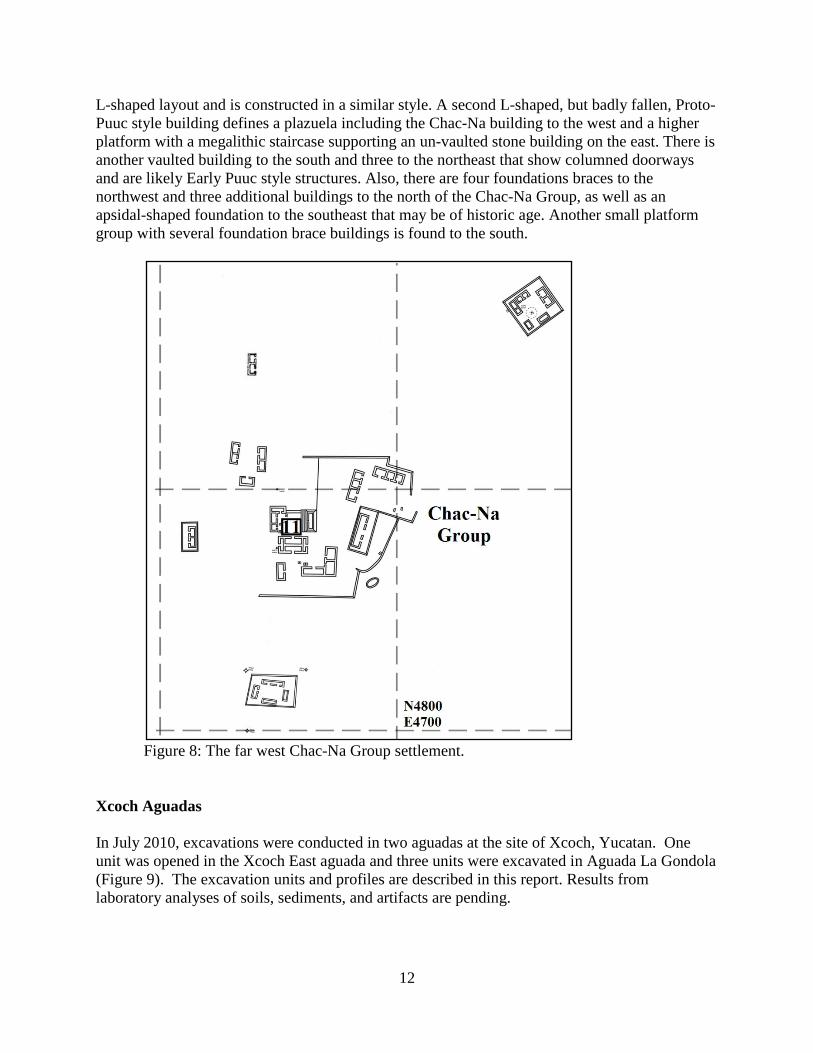
12
L-shaped layout and is constructed in a similar style. A second L-shaped, but badly fallen, Proto-
Puuc style building defines a plazuela including the Chac-Na building to the west and a higher
platform with a megalithic staircase supporting an un-vaulted stone building on the east. There is
another vaulted building to the south and three to the northeast that show columned doorways
and are likely Early Puuc style structures. Also, there are four foundations braces to the
northwest and three additional buildings to the north of the Chac-Na Group, as well as an
apsidal-shaped foundation to the southeast that may be of historic age. Another small platform
group with several foundation brace buildings is found to the south.
Figure 8: The far west Chac-Na Group settlement.
Xcoch Aguadas
In July 2010, excavations were conducted in two aguadas at the site of Xcoch, Yucatan. One
unit was opened in the Xcoch East aguada and three units were excavated in Aguada La Gondola
(Figure 9). The excavation units and profiles are described in this report. Results from
laboratory analyses of soils, sediments, and artifacts are pending.

13
Figure 9: Map of portions of the ruins of Xcoch showing the locations of Xcoch East Aguada
and Aguada La Gondola.
Xcoch East Aguada
The Xcoch East Aguada is a roughly circular depression with a diameter of about 65 m situated a
short distance east of the monumental structures on the elevated Xcoch Plaza (Figure 10). The
aguada is currently a very shallow depression just over a meter deeper in its center than
surrounding terrain. Vegetation in the depression indicates that it occasionally retains surface
water. The aguada is bounded by clear artificial berms on its north and south sides. On the west
side the aguada abuts outcopping limestone that gives the appearance of having been quarried in
ancient times. The east side the aguada is flanked by elevated plazas surmounted by
monumental architecture. Several of these plazas appear to be interconnected and canted so that
they would funnel rainwater into a clear sluiceway and thence into the aguada.

14
Figure 10: Sketch map of Xcoch East Aguada.
Xcoch East Aguada 2010 Pozo 1
Pozo 1 was a 2 x 2 meter unit excavated near the approximate center of the aguada. The unit
reached a depth of 180 cm at which point it bottomed out in sascab. The north profile of the
pozo is shown in Figure 11 and described in Table 1 below.
Based on this excavation and on the apparent quarry scars on the bedrock exposed along
the western flank of the aguada the Xcoch East Aguada can be best interpreted as having
originated as a stone or stone and sascab quarry, although it is possible that a natural depression
existed in this spot and was deepened or widened by quarrying. At a currently undated time, the
floor of the quarry was sealed with a layer of compacted (possibly tamped) clay. Ceramics
found just above the floor suggest that the reservoir was in place by sometime in the Preclassic
period. Clayey sediment began to accumulate after the floor was in place. It is not clear whether
or not dredging occurred or whether sediment accumulation was uninterrupted.

15
Figure 11: Xcoch East Aguada 2010 Pozo 1: north profile.
Table 1: Xcoch East Aguada – 2010 Pozo 1 North Profile
Depth
(cm)
Color (Munsell) OM
%
Sand
(%)
Silt
(%)
Clay
(%)
P
(ppm)
Notes
0-25 Very dusky red
(2.5YR2.5/2)
5.8 10 8 82 211 1: A: clay (+/- 2% coarse
sand); small crumbs
25-65 Dusky red
(10R3/4)
2.6 5 6 89 195 2: Bt: Boundary with A1 is
somewhat irregular due to
in-filled cracks; some
piedrine
65-140 Dark red
(2.5YR3/6)
2.3 12 9 79 300 3: C1: clay (+/- 2% coarse
sand); massive; slickensides
140-155 Dark red
(2.5YR3/6)
2.0 9 11 80 398 4: C2: clay; massive:
scattered large sherds;
carbon
155-165 Dusky red
(10R3/4)
2.5 10 4 86 245 5:clay; massive and highly
compact; carbon; possible
lining
165-180 Dark red
(2.5YR3/6)
2.2 19 7 74 114 6: marly clay; discontinuous;
located only in pockets
within sascab
165/180
+
Dark reddish
brown (2.5YR3/4)
0.5 29 2 69 7: sascab and weathered
limestone
Aguada La Gondola
Aguada La Gondola lies approximately 100 meters west of the Gruta Xcoch entrance and site
center. It is a roughly rectangular depression about 110 m on its east-west axis, 80 meters on its
north-south axis, though there is an embayment along the south side of the aguada making it

16
somewhat pentagonal in shape (figure 4). The aguada is currently about 6 meters deep. There
are sluiceways leading into the aguada at its NE and NW corners. Low berms are visible around
much of the outer rim of the aguada. Alignments of large stone blocks are visible at varying
elevations on each of the interior walls of the depression. 2009 Pozo 1 was excavated across one
such alignment situated about midway up the north wall of the aguada. Pozo 2 was begun in the
floor of the aguada but was discontinued at a depth of 110 cm due to time constraints. 2010 Pozo
1 was excavated near the center of the aguada floor and carried to a depth of 330 cm. 2010
Pozos 2 and 3 were excavated into the berm along the northern rim.
Figure 12: 3D digital elevation model of Aguada La Gondola created by Eric Weaver. North is at
the top of the image.
Aguada La Gondola 2010 Pozo 1
Pozo 1 was a 2 x 2 meter pit excavated near the center of Aguada La Gondola. The north profile
of Pozo 1 is shown in Figure 13 and described in the Table 2 below.
The excavation revealed a possible badly decomposed floor/lining at a depth of 155 cm. Well
preserved floors made of compact clay and sascab were exposed at depths of 250 and 310 cm.
The sediment immediately above each of these lower floors contained abundant sherds and
charcoal. The lowest floor was associated with only Preclassic ceramics suggesting that the
reservoir was in place early in the site’s history. Late/Terminal Classic ceramics (Cehpech)
found in the middle and upper strata suggest that the reservoir continued to be used and
refurbished. Charcoal recovered from the lower floors is not yet dated.

17
Figure 13: Aguada La Gondola 2010 Pozo 1: north profile.
Table 2 Depth
(cm)
Color (Munsell) OM
%
Sand
(%)
Silt
(%)
Clay
(%)
P
(ppm)
Notes
0-20 Reddish black
(2.5YR2.5/1)
4.8 8 9 83 308 1: A1 horizon
20-50 Dark reddish
brown (2.5YR3/3)
2.5 7 7 86 218 2: AC: Boundary with A1 is
highly irregular due to deep,
in-filled cracks; slickensides
50-60 Reddish brown
(2.5YR4/4)
2.0 5 6 89 191 3: C: massive; slickensides
60-70 Dark reddish
brown (2.5YR3/3)
2.6 11 16 73 311 4: Ab?: scattered weathered
sherds; carbon
70-100 Dark red
(2.5YR3/6)
1.5 28 7 75 267 5: 5-10% limestone
fragments; carbon; possible
lining
100-155 Dusky red
(10R3/4)
1.8 17 8 85 220 6: a few weathered sherds;
carbon
155-165 Dark reddish
brown (2.5YR3/4)
22 3 75 185 7: clay; massive; ±5% coarse
sand; charcoal; sherds;
possible lining
165-250 Dark reddish
brown (2.5YR3/4)
2.8 9 6 85 336 8: clay; massive; few sherds
except in lowest 10 cm where
sherds and charcoal are
abundant
250-257 Red (2.5YR4/8) 15 5 80 130 9: compact floor of sascab
and clay; charcoal

18
257-310 Dark reddish
brown (2.5YR3/4)
2.7 11 8 81 316 10: clay; massive; few sherds
except in lowest 5 cm where
sherds and charcoal are
abundant
310-
330+
Dark reddish
brown
(2.5YR2.5/4)
21 4 75 163 11: compact floor of sascab
and clay in matrix of cobbles;
charcoal and sherds
Aguada La Gondola 2010 Pozo 2
2010 Pozo 2 was a 1 x 2.5 m trench excavated into the berm on the northern rim of the aguada at
a point due north of Pozo 1. The east profile of Pozo 2 is shown in figure 5 and described in the
Table 3 below.
Figura 14: Aguada La Góndola 2010 Pozo 2: east profile.
Table 3 Depth
(cm)
Color (Munsell) Notes
0-10 Dark reddish
brown (5YR3/4)
1: A1 horizon ; clay
10-25 Red (2.5YR4/8) 2: AC horizon; sandy clay
25-35 Red (2.5YR4/6) 3: Decomposing floor of
sascab and clay; sherds and
charcoal
35-50 Reddish brown
(2.5YR4/4)
4: clay; massive; few sherds
50-55 Strong brown
(7.5YR4/6)
5: compact floor of sascab
and clay; charcoal
55-70 Red (2.5YR4/8) 6: Sandy clay with gravel;
massive; few sherds
70-85 Reddish yellow
(5YR6/6)
7: compact floor of sascab
and clay in matrix of cobbles;
charcoal and sherds
85+ Hard limestone bedrock

19
Floors/reservoir linings were revealed at depths of 25, 50, and 70 cm; the upper floor was
significantly decomposed whereas the lower two floors were still solid. These floors appear to
have been associated with low boulder retaining walls, though in this place those walls have
partially collapsed. The walls and floors were also exposed in Pozo 3, where these features were
better preserved.
Aguada La Gondola 2010 Pozo 3
2010 Pozo 2 was a 1 x 2.5 m trench excavated into the berm on the northern rim of the aguada at
a point about 12 m east of Pozo 2. The west profile of Pozo 3 is shown in figure 6 and described
in the Table 4 below.
Figure 15: Aguada La Góndola 2010 Pozo 3: east profile.
Table 4 Depth
(cm)
Color (Munsell) OM
%
Sand
(%)
Silt
(%)
Clay
(%)
P
(ppm)
Notes
0-10 Dark reddish
brown (5YR3/4)
3.9 8 8 84 187 1: A1 horizon ; clay
10-35 Red (2.5YR4/8) 2.0 16 7 77 164 2: AC horizon; sandy clay
35-45 Red (2.5YR4/6) 22 5 73 170 3: Decomposing floor of
sascab and clay; sherds and
charcoal
45-70 Reddish brown
(2.5YR4/4)
2.1 11 7 82 201 4: clay; massive; few sherds
70-75 Strong brown
(7.5YR4/6)
25 3 72 188 5: compact floor of sascab
and clay; charcoal
75-115 Red (2.5YR4/8) 1.8 15 6 79 211 6: Sandy clay with gravel;
massive; few sherds
115+ Reddish yellow
(5YR6/6)
27 4 69 190 7: compact floor of sascab
and clay in matrix of cobbles;
charcoal and sherds
20
Floors/reservoir linings were revealed at depths of 35, 70, and 115 cm; the upper floor was
significantly decomposed whereas the lower two floors were still solid. These floors are clearly
associated with low boulder retaining walls which appear to have been embedded in the floors
and likely served to help keep soil from washing into the reservoir. The lowest floor contained
only Preclassic ceramics and likely articulates with the lowest floor exposed in the reservoir floor
in Pozo 1. Late/Terminal Classic ceramics were recovered in mid to upper strata indicating that
the reservoir had a long use history.
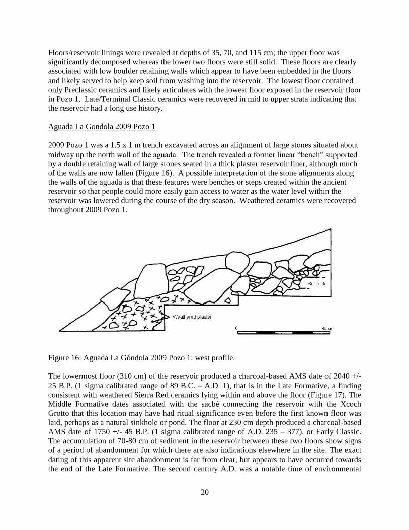
Aguada La Gondola 2009 Pozo 1
2009 Pozo 1 was a 1.5 x 1 m trench excavated across an alignment of large stones situated about
midway up the north wall of the aguada. The trench revealed a former linear “bench” supported
by a double retaining wall of large stones seated in a thick plaster reservoir liner, although much
of the walls are now fallen (Figure 16). A possible interpretation of the stone alignments along
the walls of the aguada is that these features were benches or steps created within the ancient
reservoir so that people could more easily gain access to water as the water level within the
reservoir was lowered during the course of the dry season. Weathered ceramics were recovered
throughout 2009 Pozo 1.
Figure 16: Aguada La Góndola 2009 Pozo 1: west profile.
The lowermost floor (310 cm) of the reservoir produced a charcoal-based AMS date of 2040 +/-
25 B.P. (1 sigma calibrated range of 89 B.C. – A.D. 1), that is in the Late Formative, a finding
consistent with weathered Sierra Red ceramics lying within and above the floor (Figure 17). The
Middle Formative dates associated with the sacbé connecting the reservoir with the Xcoch
Grotto that this location may have had ritual significance even before the first known floor was
laid, perhaps as a natural sinkhole or pond. The floor at 230 cm depth produced a charcoal-based
AMS date of 1750 +/- 45 B.P. (1 sigma calibrated range of A.D. 235 – 377), or Early Classic.
The accumulation of 70-80 cm of sediment in the reservoir between these two floors show signs
of a period of abandonment for which there are also indications elsewhere in the site. The exact
dating of this apparent site abandonment is far from clear, but appears to have occurred towards
the end of the Late Formative. The second century A.D. was a notable time of environmental

21
stress, including drought episodes across the Maya lowlands and witnessed site abandonments in
many regions (Dunning et al., n.d.).
Figure 17: Cross section of the north side of Aguada La Góndola.
Discussion
Excavations were conducted in two aguadas at Xcoch in 2010: the large, roughly rectangular
Aguada La Gondola situated west of the site core and the roughly circular and smaller East
Aguada located on the east side of the site core. Both aguadas clearly functioned as urban
reservoirs, with plaza pavement areas used to funnel rainwater into these depressions. The
origins of the aguadas remain somewhat unclear. Either or both may have begun as natural karst
depressions. Evidence in the form of apparent quarry scars on the western flank of the East
Aguada as well as truncation scars revealed in the bottom of the depression by our single
excavation indicate that substantial quarrying contributed to the creation of this depression
before it was modified into a reservoir. It is also possible that quarrying contributed to the
creation of Aguada La Gondola though we have yet to recover evidence of this activity there.
The East Aguada exhibits an apparently simple construction history with only one floor revealed
in our excavation at a depth of about 155 cm. The current surface of the aguada is approximately
one meter lower than the surrounding ground surface. Given the aguada’s approximate diameter
of 65 m and an approximate total depth of 2.5 m, a very rough approximation of the reservoir’s

22
ancient water storage capacity is about: 8,300 m3 or 8,300,000 liters. This capacity assumes that
the reservoir was routinely cleaned of accumulating sediment. Elevated phosphate levels and
sherds indicate that for at least the waning years of its use, maintenance of the reservoir in terms
of cleaning was allowed to lapse and sediments accumulated.
Aguada La Gondola exhibits a more complex history with three episodes of floor construction.
These floors or linings were constructed principally of a densely packed mixture of clay and
sascab – a practice still in use in Yucatan today. The linings extended up the sides of the
reservoir as revealed in our excavation in the low berm along the northern flank of the aguada
where stone retaining walls were anchored in the floors and used to build up the berm. Although
the maximum depth of the reservoir varied over time as floor and berm levels were raised over
time, the average depth of the reservoir was approximately 9 meters. Given the roughly 80 x 110
m horizontal dimensions of the reservoir, an approximate estimation of its volume would be on
the order of 79,200 m3
or 79,200,000 liters. Using a average volume of 30,000 liters for the
typical Puuc region chultun , the water storage capacity of the La Gondola Reservoir would have
been equal to about 2,640 chultunes.
Terraces or benches are evident along the interior slopes of the aguada. Our excavation of one
such bench on the north side of the aguada in 2009 revealed that it was constructed of roughly
dressed stone, rubble and plaster. These benches are set at different elevations on each side of the
aguada and likely functioned to allow access to water in the reservoir as levels dropped during
the course of the dry season each year.
Mapping and excavations conducted by Michael Smyth in 2009 revealed that the large elevated
plaza surface of the Great Pyramid acropolis was drained into Aguada La Gondola via a
plastered sluice and canal. A large low platform was constructed immediately north of the
reservoir apparently with the primary purpose of collecting rainwater and funneling this clean
water into the reservoir (Figure 10).
Aguada La Gondola also clearly had a great ritual or symbolic significance for the people of
Xcoch. A short sacbe connects the east side of the reservoir with the sinkhole in which is
located the entrance to the Gruta Xcoch. The gruta was clearly a place of vital importance, most
likely for rain god-related rituals for at least 2,000 years. At some point, the sacbe and reservoir
were added as part of a ritual complex in which one can easily imagine sacred water being
brought forth from the deep pool at the base of the cave and carried to the reservoir to
symbolically renew the filling of the reservoir by the perceived combined actions of the shamen
and rain gods. The antiquity of the reservoir’s lowest floor suggests that this ritual activity may
have begun as early as
Cumulative evidence suggests that Aguada La Gondola represents a significant investment in
human labor in its construction and maintenance and it obviously played an important role
throughout much of the long history of urban Xcoch. This role clearly included an enduring
ritual function as an element in water rituals that also involved the Gruata Xcoch, as well as a
highly pragmatic function in the collection and storage of a large quantity of water in the
seasonally arid Puuc region.

23
Xcoch and Vaca Perdida Caves
The 2010 cave project at Xcoch included Beth Cortright, Harry Goepel, Chasity Stinson, and
Eric Weaver. Additional support was provided by Dr. Michael Smyth, Dr. Nicholas Dunning,
Sebastian Smyth, and Eden Dunning. The primary goal in 2010 was to exhaust all possible leads
at Actun Xcoch in an effort to locate speleothems for paleo-climate study and, if it was not
possible to locate these at Actun Xcoch, to find a cave location in close proximity that does
contain usable speleothems. The passages in Actun Xcoch that contained unexplored areas
included the A, D, E, K, and H passages. The 2009 survey resulted in 120 stations with a
surveyed length of 735.8 meters (2,414.2 feet). The 2010 survey added 88 additional stations for
a total of 208. The total surveyed length of the cave increased by 551 meters (1,806 feet) making
the cave 1.286 kilometers long (0.80 miles). While the depth of the cave did not change as a
result of the new survey data, the outer perimeters of the cave did. The most southerly and
furthest station from the entrance is E27 (170.5 meters, 559.5 feet). Station E27 is also the
highest elevation in the cave at 47.796 meters (277.658 feet) Above Mean Sea Level (AMSL).
This station is located 3.796 meters higher than the entrance to the cave. The most northerly
station of the cave is now HI6.
Originally, the K passage had seemed to be the most likely passage to contain speleothems and
was one of the first passages to be revisited. It very quickly diminished to a size impassable by
humans and there was not enough new passage to warrant a survey of the passage to its terminus.
The D Passage was explored with slightly more success. The passage was surveyed for an
additional 19.6 meters and terminated in a large breakdown pile at an elevation of 37.403 AMSL.
A few rocks in the breakdown pile appeared to have been carved (Figures 18 and 19).
Figure 18 Figure 19
Additionally, roots were noted at this location. A surface check of the above-ground coordinates
of the cave did not find any indications of a cave entrance. There are a large number of human
bones in the area at the beginning of the D passage and their locations were surveyed (Station
DB1 and DB2). It was also noted that the altar at the junction of the D and E passages (Station
SA1) appears to have been inverted.

24
The H Passage was surveyed to its terminus, which was 46.9 meters (153.9 feet) from where last
year’s survey had stopped. A small assortment of speleothems were discovered in a small
chamber at the terminus of the H Passage. The speleothems included stalagmites, stalactites,
columns, and soda straws (Figure 20). With the exception of one soda straw, the formations did
not appear to be active. Rock hammer-marks indicated that many other formations in this area
had been removed by the Maya. Speleothems potentially useful for the paleo-climate research
were collected.
Figure 20
The E Passage was the final and most eventful of the leads. Unfortunately, it did not provide any
additional speleothems. The lead in the E Passage did not appear to hold much hope for
expansions as the previous stopping point of the survey showed an increasingly lower ceiling
with a relatively steep incline. However, further exploration resulted in the discovery of a
significant amount of new cave passage. The total passage surveyed was 397.8 meters (1305
feet). The passage is very distinct from the rest of the cave in that it is comparatively larger, the
air quality better, the temperature much cooler, and there is significant air movement present.
While it is evident that the Maya had used this passage, there is no evidence of the same kind of
ritual usage that is present in the rest of the cave. No evidence of footprints were encountered
during the survey and few torches fragments were found as well as vines that may have been
used to wrap torches. A few ceramics were located in the passage. The most prevalent sign of
past usage was large cairns used to mark off the maze of side passages (Figure 21). The presence
of the cairns is interesting as they do not appear elsewhere in the cave and their function is
unclear.

25
Figure 21
Charcoal was noted in various areas of the E passage. Toward the terminus of the main passage
in E and EK, it was evident that the floor was coated with a layer of charcoal. The E Passage is
also interesting because it terminates several meters higher than the current entrance to the cave.
This strongly suggests that the E Passage once had an entrance to the surface that may now be
buried. This observation is further reinforced by the presence of a termite nest (Figure 22) as
well as some leaves noted on the passage floor.
Figure 22
Using the coordinates based on the cave survey, a surface examination of the area was
conducted. A ground feature was noticed in close proximity to the EK and E junction. This
feature is a significant depression that appears to be ringed with shaped boulders. Later in the
week, several workers were dispatched to attempt to locate an entrance to the E Passage by

26
digging in the surface feature (Op. 22, below). While a physical connection was not made with
the surface, communication was established indicating very close proximity of the workers
digging from the surface to the surveyors in the cave. Nick Dunning collected soil samples in the
E Passage. One sample was taken near E17 (Station N1) and the other was taken at station E24.
Survey data for the cave was collected using Suunto instruments and fiberglass tape/Leica A3 for
cross-section heights using standards derived from the Cave Research Foundation. La Cueva de
la Vaca Perdida (discussed below) was surveyed using a DistoX. The above mean sea level
elevations were derived from an electronic altimeter calibrated with a GPS altimeter to give an
expected accuracy of +/- 3 meters. Calibration of the altimeter was done at a known elevation in
Cancun. Depth data is also presented based on local depth starting at 0 meters. The zero datum
for Actun Xcoch was established at the base of a tree at the top of the sink (44 meters AMSL).
Zero datum was established at Cueva de la Vaca Perdida at the base of a tree at the top of the pit.
The other cave visited was named Cueva de la Vaca Perdida (Cave of the Lost Cow). The cave is
11.04 kilometers due east of Xcoch Cave. It was surveyed for a total length of 85.8 meters
(281.85 feet). The depth of the cave was 32.1 meters (105.4 feet) and begins with an eight meter
drop into a large chamber (Figure 23).
Figure 23
The upper layer of the cave consists of two primary chambers. The second chamber was
separated from the first by a breakdown pile of massive boulders. The connection to this second
chamber is a steep slope that traverses past a large breakdown pile. There appears to be a built-up
wall next to steps cut in the floor to help negotiate the steep incline. Small quantities of ceramic
sherds were noticed in the second chamber and have been identified as Yokat Striated and
Chemax slateware water jars as well as sherds of a Chemax slateware bowl dated to the Late and
Early Classic periods. An associated wood charcoal specimen produced an uncalibrated
radiocarbon dated of AD 320 +/-30. Additional ceramics were found in an alcove that was only
accessible by climbing a flowstone wall. A pila was found in the second chamber and it was
included in the survey as Station A6Pila (Figure 24).
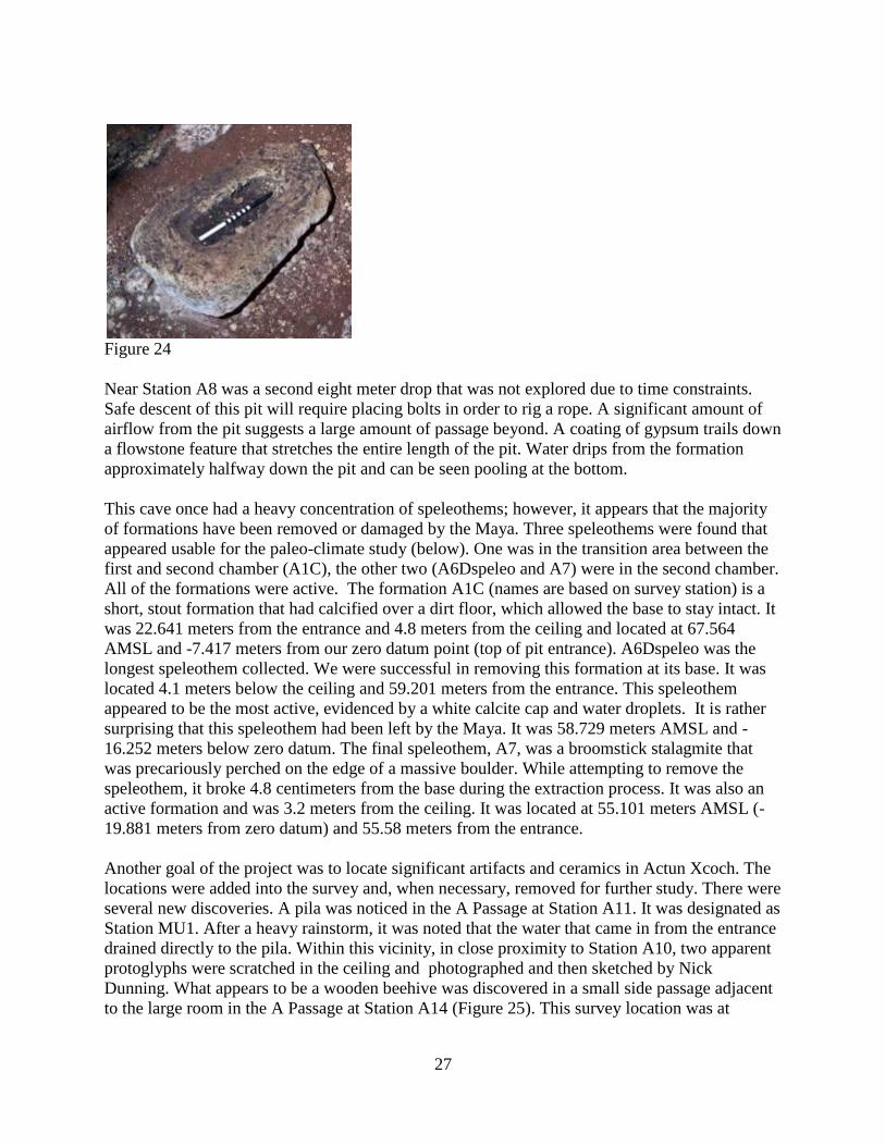
27
Figure 24
Near Station A8 was a second eight meter drop that was not explored due to time constraints.
Safe descent of this pit will require placing bolts in order to rig a rope. A significant amount of
airflow from the pit suggests a large amount of passage beyond. A coating of gypsum trails down
a flowstone feature that stretches the entire length of the pit. Water drips from the formation
approximately halfway down the pit and can be seen pooling at the bottom.
This cave once had a heavy concentration of speleothems; however, it appears that the majority
of formations have been removed or damaged by the Maya. Three speleothems were found that
appeared usable for the paleo-climate study (below). One was in the transition area between the
first and second chamber (A1C), the other two (A6Dspeleo and A7) were in the second chamber.
All of the formations were active. The formation A1C (names are based on survey station) is a
short, stout formation that had calcified over a dirt floor, which allowed the base to stay intact. It
was 22.641 meters from the entrance and 4.8 meters from the ceiling and located at 67.564
AMSL and -7.417 meters from our zero datum point (top of pit entrance). A6Dspeleo was the
longest speleothem collected. We were successful in removing this formation at its base. It was
located 4.1 meters below the ceiling and 59.201 meters from the entrance. This speleothem
appeared to be the most active, evidenced by a white calcite cap and water droplets. It is rather
surprising that this speleothem had been left by the Maya. It was 58.729 meters AMSL and -
16.252 meters below zero datum. The final speleothem, A7, was a broomstick stalagmite that
was precariously perched on the edge of a massive boulder. While attempting to remove the
speleothem, it broke 4.8 centimeters from the base during the extraction process. It was also an
active formation and was 3.2 meters from the ceiling. It was located at 55.101 meters AMSL (-
19.881 meters from zero datum) and 55.58 meters from the entrance.
Another goal of the project was to locate significant artifacts and ceramics in Actun Xcoch. The
locations were added into the survey and, when necessary, removed for further study. There were
several new discoveries. A pila was noticed in the A Passage at Station A11. It was designated as
Station MU1. After a heavy rainstorm, it was noted that the water that came in from the entrance
drained directly to the pila. Within this vicinity, in close proximity to Station A10, two apparent
protoglyphs were scratched in the ceiling and photographed and then sketched by Nick
Dunning. What appears to be a wooden beehive was discovered in a small side passage adjacent
to the large room in the A Passage at Station A14 (Figure 25). This survey location was at
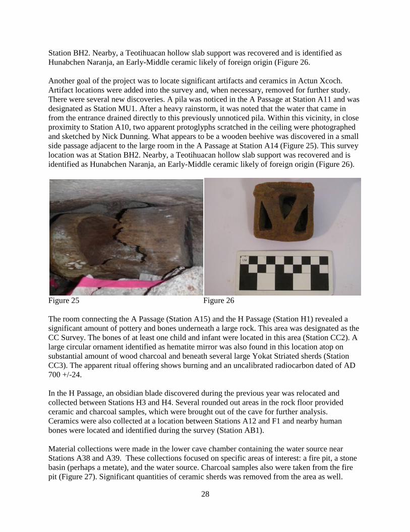
28
Station BH2. Nearby, a Teotihuacan hollow slab support was recovered and is identified as
Hunabchen Naranja, an Early-Middle ceramic likely of foreign origin (Figure 26.
Another goal of the project was to locate significant artifacts and ceramics in Actun Xcoch.
Artifact locations were added into the survey and, when necessary, removed for further study.
There were several new discoveries. A pila was noticed in the A Passage at Station A11 and was
designated as Station MU1. After a heavy rainstorm, it was noted that the water that came in
from the entrance drained directly to this previously unnoticed pila. Within this vicinity, in close
proximity to Station A10, two apparent protoglyphs scratched in the ceiling were photographed
and sketched by Nick Dunning. What appears to be a wooden beehive was discovered in a small
side passage adjacent to the large room in the A Passage at Station A14 (Figure 25). This survey
location was at Station BH2. Nearby, a Teotihuacan hollow slab support was recovered and is
identified as Hunabchen Naranja, an Early-Middle ceramic likely of foreign origin (Figure 26).
Figure 25 Figure 26
The room connecting the A Passage (Station A15) and the H Passage (Station H1) revealed a
significant amount of pottery and bones underneath a large rock. This area was designated as the
CC Survey. The bones of at least one child and infant were located in this area (Station CC2). A
large circular ornament identified as hematite mirror was also found in this location atop on
substantial amount of wood charcoal and beneath several large Yokat Striated sherds (Station
CC3). The apparent ritual offering shows burning and an uncalibrated radiocarbon dated of AD
700 +/-24.
In the H Passage, an obsidian blade discovered during the previous year was relocated and
collected between Stations H3 and H4. Several rounded out areas in the rock floor provided
ceramic and charcoal samples, which were brought out of the cave for further analysis.
Ceramics were also collected at a location between Stations A12 and F1 and nearby human
bones were located and identified during the survey (Station AB1).
Material collections were made in the lower cave chamber containing the water source near
Stations A38 and A39. These collections focused on specific areas of interest: a fire pit, a stone
basin (perhaps a metate), and the water source. Charcoal samples also were taken from the fire
pit (Figure 27). Significant quantities of ceramic sherds was removed from the area as well.

29
These samples provided a number of painted ceramic pieces, among them including Chac
polychome and Chemax slateware jars as well as Preclassic diagnostics. Additionally, an
attempt was made to assess the depth of the ceramic deposits in this area (Figure 28).
Figure 27 Figure 28
The antechamber that housed the stone basin (Station A34B) provided several interesting
artifacts. A circular stone was found that may represent a griddle, or comal. Close to the circular
stone, a decorated tube-like item with incised decoration was found that appears the an ultra thin
rim portion of a blackware (Dzitya negro) miniature vessel. Incised decoration near the top of the
rim shows a horizontal line circumventing the rim and three connected u-shaped design with
vertical lines dangling from the top and may be a motif representing a cave. A second incised
line is below that shows three sets of two inverted curved lines that do not intersect that may be
water symbols resembling grecas. Near the miniature vessel rim were a piece of coral and shell.
These items appear to be components of a necklace. Quantities of ceramics was also removed in
this area. The water source (Station A38) was also sampled with surface collections. One brown
ware sherd from large bowl or basin shows a blackline painted fish motif that has not been
identified but may be a Preclassic ware.
It would appear that the survey has exhausted all leads at Actun Xcoch in regards to the search
for speleothems (Figures 29a-d). There remains a wealth of information contained within Actun
Xcoch that can help us understand its connection with the surface architecture and the utilization
of the cave by the Maya. It is amazing that a cave that contains so many archaeological resources
could be so well known, but yet so largely ignored. This brings about the question what other
caves in the area, known and unknown, may contain. La Cueva de la Vaca Perdida is another
example of a previously unknown cave that is not even known by most local residents. It was
only explored in the last days of the project because of the limited success at Actun Xcoch in
obtaining speleothem samples for the paleo-climate study. At la Vaca Perdida we had great
success in locating and obtaining speleothems; additionally, it was discovered that the ancient
Maya had reached this cave despite the 8 meter drop at the entrance pit. A second 9 meter pit
was discovered during the survey. The mouth of the pit had a glowing, white calcite crust coating
a flowstone formation that stretched to the floor of the pit. Water continuously dripped from the
flowstone into pools of water and a strong, cold wind bellowed out. The surveyors were certain

30
that this pit had also been negotiated by the Maya. As time was limited and the primary goal to
obtain speleothems, this intriguing pit had to be left unexplored.
Figure 29a : Map of Cueva la Vaca Perdida.
Figure 29b: Profile of Cueva de la Vaca Perdida with station number, elevation, and
distance from entrance.

31
Figure 29c: Profile of Cueva de la Vaca Perdida with walls, station number and elevation.
Figure 29d: Lineplot of Actun Xcoch that includes the 2010 data.

32
Stratigraphic Excavations
Test pit operations (Op.) consisting mostly of 2 x 2-m units were excavated in levels following
natural or cultural stratigraphy in architectural contexts at many settlement localities across
Xcoch (Figure 1). Most excavations produced typical Cehpech ceramics (800-1000 AD) in the
upper levels. Nevertheless, significant quantities of ceramic diagnostics such as Late-Middle
Classic Motul (600-800 AD), Early Classic Cochuah (300-600 AD), and Preclassic Mamom and
Tihosuco complexes (800/700-400/300 BC) were found in stratigraphic association with early
architecture. Excavation data supported by radiocarbon dating clearly demonstrate that Xcoch
had a large occupation during the Preclassic period.
Stratigraphic excavations continued in 2010. Ops. 24, 25, and 27 sampled a settlement area
known as the Cuevas Groups located about 500 m southeast of the Great Pyramid (Figure 3).
Stucco floors surfaces were found in Op. 24 adjacent to a conical altar and in all units Cehpech
ceramics predominated with moderate amounts of Early Classic wares in the lower levels. Ops.
26 and 30 sampled the Chikin Mul Group and probed the platform center and south retaining
wall (Figure 4); both units contained significant quantities of Preclassic diagnostics within
architectural fill. Ops. 29 and 31 were deep stratigraphic cuts between the Chich platform and the
north berm of the Aguada La Gondola. Op. 29 clearly showed that the Chich Platform's cobble-
stone surface slopes southward towards the aguada and was constructed upon a prepared surface
composed of a >1 m layer of finely sifted, compacted red kancab soil. Op. 31 revealed a 15 m
stone-free zone between the Chich Platform and the aguada berm that consists of a thick layer of
red kancab-alkache clay lining mottled with white sascab. This clay lining, identical to the lining
found inside the aguada, was very hard and water tight and clearly engineered to seal the ground
surface so rainwater could flow parallel to the aguada berm and discharge into the aguada at its
corners; there is no evidence of any drain hole or sluice gate penetrating the north berm wall. In
both units Cehpech ceramics predominate in the upper levels but Preclassic wares associate with
the lower levels suggesting that both features were originally Preclassic constructions.
Ops. 33 and 34 sampled the platform surface immediately south of the Xcoch Grotto, an area
forming a terminus for the West Sacbe (Figures 30a-b). These units produced a wide variety of
Preclassic to Postclassic ceramics, most notably water jar and incense burner forms, including
Early Classic Chac Polychrome, and Postclassic Chichen and Mayapan diagnostics. Ops. 36 and
37 sampled the West Sacbe itself about 50 m west of the Gruta to show that this causeway was
constructed during the latter part of the Preclassic period (Figures 312a-b). Sacbe fill was
superimposed upon three preserved stucco floors associated with Middle Preclassic potsherds as
well as marine shell and serpentine flakes. A wood charcoal sample taken from beneath the
lowest stucco floor dated to 640 B.C. (Table 5). These data indicate the space adjacent to the
cave was paved even before the Preclassic construction of the West Sacbe and part of a west
extension of the Great Acropolis.

33
Figures 30a-b: Photos of Op.33 looking north and sherds of Postclassic Mama red incense
burners.
Figures 31a-b: Photo and north profile drawing of the West Sacbe.
Ops. 35, 38, and 39 were probes into the plaza surfaces east and southeast of the Grand Platform.
Two units, Op. 35 and 38, were placed to the west of two pyramid structures that are part of the
settlement zone known as the Eastern Elite District (Figures 32a-b and 33a-b). Both pyramid
contexts contained numerous stucco floor surfaces. Op. 38 had two stucco floors while Op. 35
produced five stucco floors set upon leveled bedrock with 2-3 m layers of large and medium size
boulders and cobblestones. Ceramics indicate that the upper floors date to the Late-Early Classic
periods while the lowest floors and original plaza surfaces were Preclassic. A wood charcoal
sample below Floor V of Op. 35 produced a radiocarbon date of 570 +/- 30 BC (Table 5).
Indeed, it seems that both pyramids were probably Preclassic structures with only the northeast
pyramid (Op. 38) showing later reutilization in the form of a vaulted temple building erected on
its summit. The southeast pyramid (Op. 35) supported some form of non-vaulted roof building.
Op. 39 sampled the edge of the Grand Platform's southwest wing and it too produced quantities
of Preclassic diagnostics.

34
Figures 32a-b: Photos of the SE Pyramid and Preclassic floors of Op. 35.
Figures 33 a-b: Photos of the NE Pyramid and stucco floor surfaces and platform fill in Op. 38.
Op. 41 was a 2 m wide trench extending from the cave entrance to 12 m west (Figure 34). This
trench exposed the original descending staircase that, surprisingly, shows many of its original
megalithic treads and risers in situ and still usable as an access into the cave itself. Clearly, there
must have been a U-shaped megalithic stairway integrated into three sides of the depression or
sinkhole descending into the cave entrance. Because of the downsloping surface, the thousands
of the ceramics recovered, have little stratigraphic integrity. Preclassic to Postclassic sherds and
even some modern debris, however, demonstrate that this water cave has been continuously
visited over the past 3000 years, if not earlier.

35
Figure 34: Photo of the Gruta Xcoch staircase after the completion of Op.41.
Ops. 42 sampled the Old Pyramid Group's pyramid platform on the west and Op. 43 probed the
north side of the Chac-Na Group's Proto-Puuc building. Op. 42 produced no recognizable floor
surface but plenty of Preclassic ceramic diagnostics associated with unusual foundation stones
set as upright boulders. It seems likely that the pyramid and it associated platform as well as
many of the house foundations are Preclassic, though there was clearly a substantial Late Classic
reoccupation. The Chac-Na operation (43) recovered an Early-Middle Classic Say slateware
chultunera buried deep within level 1 that must have been a dedicatory offering for the nearby
Proto-Puuc building (Figures 35a-b). Associated with the chultunera were a number of Early
Classic diagnostics and a preserved stucco floor below. This stucco floor yielded pure Preclassic
pottery and strongly suggests that much of the Chac-Na group was built upon a Preclassic basal
platform.

36
Figuras 35a-b: Photos of the Chac-Na building, Op. 43, and a Early Classic Say Slateware
chultunera offering.
Ceramic Analysis
The 2006, 2009, and 2010 field seasons at Xcoch recovered 53,934 ceramic sherds that were
analyzed using the type-variety classification system, employed by most Maya ceramists in the
Yucatan during the last four decades. Adapted for the identification and comparison of
analytical units from different sites, this system allows one to infer cultural relations between
different sites of the Maya area through time (Sabloff 1975: 3; Robles 1990:25). Modified type-
variety classifications and formal ceramic analysis employed at Sayil, Chac II, and now Xcoch
are also designed to extract behavioral information from analyzed pottery using surface
collections and test excavations. In addition to ceramic types, which can provide the relative age
and cultural affiliation, the ceramics are also classified according to vessel type which provide
vessel form assignments and functional information on vessel assemblages related to cooking,
serving, and storage activities.
In most excavations the ceramics recovered near the surface are identifiable as typical of the
Cehpech ceramic complex of the Late–Terminal Classic period including Yocat striated, Muna
slate, Ticul thin, Teabo red, and Holactun. There are, nevertheless, significant numbers of Early
Classic types including polychromes such as Chac, Timucuy, and Dos Arroyos within the middle
levels. In almost every test pit, the lower levels produced Preclassic diagnostics such as
Chancenote striated, Chunhinta black, Joventud red, Sierra red, Dzudzuquil cream to buff,
Muxanal red on cream, among others. Within the Xcoch cave, there are the remains of at least
three large hemispherical vessels with cylindrical monopod supports and long narrow necks
identified as Yotolin Patterned Burnished, among the earliest ceramics of Yucatan, (Brainerd
1958; Smyth and Ortegón 2008). There is no agreement on the dating of these mysterious
ceramics only found near Mani, Sacalum, Loltun Cave, Tzucacab, and now Xcoch. It it is largely

37
agreed, however, that Yotolin Patterned Burnished dates to the early Middle Preclassic thought
some have argued for an Early Preclassic date (Brainerd 1958; Folan 1968; cf. Andrews V
1990). Its finding underneath the Cave Pyramid in the middle of a Preclassic center is very
significant and importantly suggests that the producers and the consumers of this early ceramic
ware lived nearby.
The presence of early ceramics in many surface units cannot be a random pattern. The surface
survey collected 14,067 sherds from 869 3x3 m collection units resulting in an average of 16.2
sherds per collection unit. As expected, most surface ceramics are of the Cehpech complex;
almost all are Yokat striated and Muna slate types without decoration and there are few fine
paste wares (150 sherds or ~ 1%). This pattern is very unusual given the fact that the majority of
the collections have come from in and around the central monumental zone of Xcoch, including
the Eastern Elite District and the North Brecha where there is much monumental architecture.
These same kinds of contexts produced significant quantities (~5%) of fine paste ceramics in the
previous surface surveys of Sayil and Chac II (Smyth et al. 1995; Smyth et al. 1998). Also at
Xcoch, the frequencies of Muna slate are greater than the frequencies of Yokat striated(water
jars). At Sayil and Chac II, and presumably other major Puuc sites, Yokat striated comprises
more than 60% of all the ceramics found on the surface. So far, Early Classic and Preclassic
ceramics at Xcoch are found within 32 different surface units and, approximately 1 Preclassic
sherd for every 43 squares. These surface patterns suggested a major Preclassic occupation
during the 2006 season (Smyth and Ortegón 2008) and have been absolutely confirmed by test
excavation and radiocarbon dating in 2009 and 2010. Indeed, the surface survey at Sayil
produced very few Preclassic ceramics within 5,261 squares and at Chac II there were no
Preclassic sherds from 3,970 collection units.
The stratigraphic test pits at Xcoch collected 53,910 sherds many associated with stucco floors,
architectural stratigraphy, and wood charcoal samples. Within upper level contexts (Late
Classic), a total of 46,539 sherds (86%) were recovered, though a certain percentage may be
transitional types such as Yokat striated that may have begun in the Early Classic period.
However, 5,128 Late Classic sherds came from Chultun 2 (Op. 15) and 5,527 sherds were from
the Gruta Xcoch staircase trench (Op. 41) and because of considerable mixing of these deposits
skew representative ceramic samples at the site level. Removing the ceramic totals from Chultun
2 and the cave trench leaves 3,317 sherds (9 %) in the middle levels diagnostic of the Early-
Middle Classic periods. In the lowest levels Preclassic 3,410 sherds (10%) of which the majority
appear to be Middle Preclassic were recovered. These data show that the center of Xcoch had a
significant occupation during Middle Preclassic, a time when many of the site's largest
monuments were constructed or at least initiated. In most test pits clear hiatus zones are seen
between the upper and lower levels indicated a general site abandonment at the end of the Late
Preclassic period. The ceramics also suggest that site was reoccupied later in the Early Classic
period In fact, both ceramic and architectural data converge to show Preclassic occupation at
nearly all settlement areas covered by survey or almost 1 square kilometer. Excavations at
Xcoch also have been attuned to identify Preclassic ceramic diagnostics comparable to Early
and Late Nabanché phase (Xanilá Complex) materials. In addition toYotolin Pattern Burnished,
long-neck monopod water jars, like those found in the Xcoch cave (above), other early
diagnostic forms encountered at Xcoch include temocates (neckless hemispherical jars) and

38
everted, outward-sloping flanged bowls typical of early Nabanché ceramics at Komchén on the
northern coastal plain. The ceramic analysis, of course is a work still in progress.
Radiocarbon Dating
Twenty-eight wood charcoal samples were submitted to the National Ocean Accelerator Mass
Spectrometry Facility (NOSAMS) for radiocarbon dating in 2009 and 2010 (Table 5). These
samples were recovered from Ops. 4-8, 15, 26-27, 32, 35, 36, the South Aguada, the Gondola
Aguada, the East Aguada, the Gruta Xcoch, and La Vaca Perdida Cave (11 km east). Four
samples are modern or Historic and are likely the result of contamination, four are Colonial,
seventeen samples were prehispanic, and two samples are in progress. The most notable were
seven Middle Preclassic dates from the lower levels of the Grand Platform, Xcoch Plaza, the
Grupo Residencial, the East Pyramid Plaza, and the West Sacbe, all associated with Middle
Preclassic diagnostic ceramics. These dates clearly show that much of the central architecture at
Xcoch was constructed between the 5th
and 8th
centuries BC and represent among the earliest and
largest monumental constructions in northern Yucatan. A Late Archaic to Initial Formative date
came from deep within the Chikin Mul platform (Op. 26). One Late Preclassic date is from the
La Gondola Aguada. Four Early Classic dates were associated with the La Gondola Aguada,
South Aguada, Chultun 2 (Op.15), and the Vaca Perdida cave, a time when Xcoch was being
reoccupied after initial abandonment in the Late Preclassic period. Three Postclassic dates from
the Gruta Xcoch indicate that the cave was still being visiting long after major site abandonment
in the Terminal Classic. No radiocarbon assays so far date to between 800 and 1000 AD, a
finding that is consistent with the lack of certain Terminal Classic diagnostic ceramics at the site.
Table 5: Radiocarbon dates from Xcoch, Yucatán. All dates were calculated using the Accelerator Mass
Spectrometer (AMS) technique from the National Ocean Accelerator Mass Spectrometry Facility (NOSAMS) and
the Calib Radiocarbon Calibration Program.
Field Lab Num. Conventional Uncalibrated Calibrated C-14 BC/AD Context Specimen NOSAMS C-14 Age BP Calendar Date (2 sigma, 96% probability) 20013 78754 1460+/-25 490 AD 560-646 AD Aguada S, Pozo 1(200 cm) 20020 78755 305+/-30 1645 AD 1488-1603 and 1609-1651 AD Aguada Gondola, Pozo 2 (100 cm) 20045 78756 2520+/-30 570 BC 716-792 and 539-695 BC Grand Platform, Op. 4, Lev. 6 - Piso V 20046 78757 2550+/-30 600 BC 743-800, 663-689, and Grand Platform, Op. 4, Lev. 7 - 549-647 BC Piso VI 20059 78758 2560+/-25 610 BC 749-802, 666-687, 591-641, Xcoch Plaza, Op. 5, Lev. 11 - Piso 567-578 BC X 20063 78759 145+/-30 1805 AD 1668-1710, 1717-1781, 1797- Gr. Platform SW, Op. 6 ext. 2, Lev. 1891, and 1909-1948 AD 1 20072 78760 2570+/-25 620 BC 751-806, 667-686, 623-634, Gr. Platform, Niche Bldg, Op. 7, 594-614 BC Lev. 3 - Piso II 20076 78761 330+/-25 1620 AD 1483-1641 AD Grp. Residencial, Op. 8, Lev. 3 - Piso II 20078 78762 Modern Grp. Residencial, Op. 8, Lev. 5 - Piso IV 20079 78763 245+/-25 1705 AD 1528-1552, 1633-1673, 1778- Grp. Residencial, Op. 8, Lev. 6 - 1799, and 1942-1951 AD Piso V 20082 78764 2490+/-30 540 BC 508-776, 454-458, 419-438 BC Grp. Residencial, Op. 8, Lev. 9 - Piso VIII 20088 78765 625+/-25 1325 AD 1291-1331, 1338-1397 AD Chultun 2, Op. 15, Lev. 4 (270 cm) 20089 78766 1420+/-30 530 AD 581-660 AD Chultun 2, Op. 15, Lev. 5
20124 84303 1750+/-45 200 AD 139-160, 165-196, 209-398 AD Aguada Gondola, Pozo 1 (230cm), Lev. 5 20126 84304 2040+/-25 90 BC 135-159, 114 BC-24 AD Aguada Gondola, Pozo 1 (310cm)
20131 84305 Modern E. Aguada, Lev. 2
20162 84306 4010+/-30 2060BC 1748-3356 BC Chikin Mul, Op. 26, Lev. 3
20168 84307 1280+/-30 670 AD 662-779,794-801 AD Grp. Cuevas, Op. 27, Lev. 7

39
20185 84308 140+/-30 1810 AD 1669-1713,1716-1780, 1798-1891 Mega. F.B., Op. 32, Lev. 3 (150 cm)
1908-1944 AD 20193 84309 2520+/-30 570 BC 716-792, 695-539 BC E. Pyr. Plaza, Op. 35, Lev. 8, Piso V (below)
20198 84310 2590+/-30 640BC 763-809, 673-680 BC W. Sacbe, Op. 36, Lev. 8, Piso III (below)
21001 84311 1250+/-25 700 AD 678-784, 786-827, 839-864 AD Gruta Xcoch, Sta. CC3 (A Passage) 21005 84312 175+/-25 1775 AD 1661-1694, 1727-1813, 1839- Gruta Xcoch, Sta. A4 (A Passage), 1-20 cm
1842, 1853-1859, 1862-1867 AD
21014 84313 645+/-25 1305 AD 1283-1324, 1346-1393 AD Gruta Xcoch, Fire Pit (10 cm), A38 21014A 84314 525+/-30 1425 AD 1322-1347, 1392-1441 AD Gruta Xcoch, Fire Pit (25 cm), A38
21019 84315 385+/-30 1565 AD 1449-1499, 1502-1512, 1601- Gruta Xcoch, Torch, Sta. E13
1616 AD 21020 84316 225 +/-55 1725 AD 1513-1600, 1617-1706, 1719-1820 Vaca Perdida (30 cm)
1822-1825, 1832-1884, 1913-1953
20121 84317 1630+/-30 320 AD 348-369, 378-535 AD Vaca Perdida, Sala 2
Speleothem Analysis
The speleothem paleoclimate reconstruction component of this study attempted to provide a
more detailed understanding of the variability of precipitation for the Xcoch and Puuc Region of
the Yucatan, Mexico. As mention above, the Terminal Classic Period, 800-950 C.E. or 1200-
1050 year BP (before present) is the time span of interest. The BP chronological terminology
will be used hereafter. In 2010 speleothems were initially collected from Xcoch Cave below the
archaeological site. Upon closer examination, these formations were found to be portions of
stalactites and other secondary calcite deposits which could not be used for the paleoclimate
reconstruction. After corresponding with Dr Michael Smyth, new speleothems were collected
from a nearby cave, la Vaca Perdida (VP). These three stalagmites were of varying length and
the two most complete speleothems were selected for the paleoclimate study. The samples were
then analyzed for their periods of deposition and stable isotope composition. It was hoped that
this analysis could shed light of how potential abrupt precipitation changes, such as prolonged
droughts, for this particular site may have been partially responsible adding pressure to the
Maya people of this region.
Figure 36 (1) below shows the location of the Xcoch study area in the Yucatan Peninsula,
Mexico. The other locations shown are either other archaeological sites or where paleoclimate
studies have been conducted. Of particular interest are the Tecoh Cave and Lake Chichanacanab
sites which will both serve as records that will help create a chronology for our speleothem
record and its interpretation.
Methods
Sample Selection
The two stalagmites, VP-10-1 and VP-10-2 were collected from Vaca Perdida Cave which is
~11.04 km east of Xcoch Cave. The cave is entered through an 8 m shaft which ends in a large
chamber where many of the speleothems had been removed or damaged by the Maya. These
two formations appeared to be active in that water was dripping of their terminuses. VP-10-1 is
~450 mm in length and was located 60 m from the entrance and appeared to have recent
deposition as evidenced by the presence of a white calcite cap and water droplets. VP-10-2 is a
boss stalagmite ~ 150 mm long and was collected 23 m from the entrance. In the laboratory each

40
speleothem was cut along its c-axis, and then polished. Fourteen and seven 300 mg samples of
calcite were removed along each growth axis of VP-10-1 and VP-10-2 respectively, using a
computer-controlled micro-drill equipped with a dental burr. These samples were then analyzed
for their ages using U-series dating (see below section). The same micro-drill was then used to
remove 200 μg samples at 5 mm intervals along the growth axis for each speleothem. These were
needed for stable isotope analysis.
Figure 36
Dating Techniques
Uranium series dating techniques, specifically 234
U-230
Th, were used in order to determine
accurate dates for each speleothem and completed at the Radiogenic Isotope Laboratory at the
University of New Mexico. 50-150 mg of carbonate powder for the samples were dissolved in
nitric acid and spiked with a solution of 233
U and 229
Th of known concentration. These were then
dried, redissolved in nitric acid and perchloric acid. The samples were again dried, dissolved in
nitric acid, and added to anion resin columns to separate the thorium and uranium. Once
separated, the thorium and uranium from each sample was run through the ICP-MS. Due to the
low counts of 234
U and 230
Th, the more sensitive SEM is used to measure the amounts of these
isotopes.
Stable Isotope Measurements
Once the calcite samples were collected from the speleothems, they were weighed to ~200 μg for
stable oxygen isotopic analyses. The calcite was then placed in individual reaction vessels,
subjected to anhydrous phosphoric acid in the Keil III carbonate-extraction system coupled to a

41
ThermoFinnigan DeltaPlus XL mass spectrometer. The standard used with conjunction with the
cave calcite was the NBS-19 standard which allowed a precision of <0.1‰.
Results
U-series dates
The ICP-MS ages for each speleothem are given in Table 6. Despite the best efforts of Anna
Leech (my research assistant) and Dr. Victor Polyak (UNM), accurate ages for the speleothems
could not be obtained. However, the top and base dates for VP-10-1 appeared to be usable due to
the low detrital Th and the fact that they were chronological order. The top date for this
speleothem also agreed with the top date of VP-10-2, hence this was used for the date that the
speleothems cessation of deposition. The construction of the age model for VP-10-1 was simply
based on the linear interpolation between the top and base dates. This age model was then used
to create a time series for the VP-10-1 stable isotopes values (see Figure 37(2). With the poor
chronological control, a comparison to another, well dated, nearby speleothem record (Tecoh
Cave, Medina-Elizalde et al. 2010) was used to help constrain our age model.
Table 6. ICPMS ages for VP-10-1 and VP-10-2. Speleothem Distance from Top
(mm)
Age (yr BP)
VP-10-1 3 589± 224
30 278± 273
57 -2± 364
91 2791± 1746
121 -6363± 5293
140 1703± 221
173 2346± 327
182 975± 232
217 801± 262
257 816± 218
339 551±476
425 449±346
435 811±144
450 2026± 387
VP-10-2 27 580± 88
43 -19607± 9306
58 1616± 1242
89 -14644± 9715
106 319± 156
127 298± 99
153 1677± 215
Oxygen isotope record for VP-10-1
Figure 37 (2) show the time series for the oxygen isotopes for VP-10-1. The 18
O values for
speleothems in the tropics and this region have been found to record changes in precipitation.
The cause of this variability in the 18
O is due to the amount effect (Lachniet et al. 2004).
Consequently, more (less) depleted values in the speleothem are indicative of wetter (drier)
conditions. As found in the speleothem c-axis profile, there were numerous hiatuses in the top
third of the speleothem. The more prominent of these are marked on Fig. 37 (2). H2 and H
3 are

42
two very pronounced events where two and three hiatuses occurred in rapid succession.
Cessation in deposition is normally induced by drought conditions.
Figure 37
Comparison with other Yucatan paleoclimate records
To check the accuracy of the VP-10-1 chronology and our reconstruction of precipitation
variability, two different proxies were used. The first is a speleothem record from Tecoh Cave
(Chaac 18
O record, Fig. 38(3)a) which is north of our field site (Figure 36(1). Once again, the
Chaac 18
O isotopic values are interpreted as wetter conditions. Both speleothems, VP-10-1 and
Chaac, are plotted on the same y-axis and possess not only very similar 18
O values but also
similar amplitudes. Consequently, our linear interpolation for VP-10-1 appears to be quite
accurate when compared to the well dated Chaac chronology. Any differences in the timing of
abrupt changes in the 18
O values can be attributed to the frequent hiatuses in our speleothem,
differing growth rates and data resolutions between each record. The Lake Chichanacanab 18
O
record (Hodell et al. 2001) further solidifies both the accuracy of our chronology and our
precipitation reconstruction (Fig. 38(3)b).

43
(Figures 38 a-b)
Terminal Classic Period (TCP)
The TCP is of great interest to paleoclimatologists since it was suggested that major droughts
may have contributed to the Maya collapse during this interval. Medina-Elizalde et al. (2010),
while not being the first study to investigate this question, has the most detailed and quantitative
analysis of this period to date. The authors demonstrated the possible impact of decreasing
precipitation on the Maya society in their region of the Yucatan. They suggest precipitation may
have been 300 mm below the long term average for their region (Figure 39(4).

44
Figure 39
A subsection of the Chaac speleothem record is highlighted in Figure 39(4) showing
precipitation changes for the Tecoh Cave region during the TCP. Medina-Elizalde et al. (2010)
detailed depiction of the TCP demonstrates both rapid changes in precipitation and pronounced
droughts, which coincide with pivotal demographic changes for the Maya. One overlying
objective of this study is to determine whether these abrupt shifts in precipitation shown above
were local or more widespread. Precipitation amounts in the Yucatan can vary greatly, even
across relatively short distances. In addition, even if the same climate shift occurred across the
Yucatan, would its magnitude be uniform or vary locally? For example, could a locale in the

45
same geographic area, such as the Yucatan, experience a different magnitude of change in
rainfall compared to another?
Figure 40
In a preliminary attempt to address these questions, Figure 40(5) displays the Chaac
reconstruction of precipitation compared to that of VP-10-1. It is readily apparent that there is a
great difference in the resolution of data between the two records. However, there are still
several pertinent observations that can be made from this comparison. First, the major changes in
precipitation measured at Tecoh Cave (Chaac), especially the prominent droughts, are also found
at Vaca Perdida (VP-10-1). Second, the magnitude of change in rainfall at Vaca Perdida appears
to be somewhat subdued when matched with the Chaac record. However, it should be noted that
this observation may simply be an artifact of the lower resolution of the Vaca Perdida
speleothem record.
Summary
The preliminary nature of this pilot study must preclude any definitive conclusions about the
magnitude and timing of precipitation changes at the Vaca Perdida region of the Yucatan over
the last 2000 years. The low resolution of the oxygen isotopic record and the issues with the
chronology are two major reasons for this tentative approach. However, if the observations
outlined in this report have some validity, then an expanded study is warranted. This could entail
a higher resolution stable isotope record, possible 14
C dating constrained by the two reliable U-
series dates, and even investigating the possibility of annual laminae in the speleothem. This last

46
mode of study can help to create greater precision for the chronology, a technique long
undertaken in dendrochronology. There are very clear laminations throughout the speleothem.
Consequently, although there are obstacles to overcome, further study may well show subtle, yet
potentially important differences in climate change in the Yucatan Peninsula.
Discussion
The beginnings of sedentary farming communities, complex societies, and early community
organization in the Puuc region are being be addressed by the multidisciplinary work at Xcoch
and vicinity. Multiple data sources are helping identify patterns of Preclassic chronology,
community structure, and culture process: indigenous development versus in-migration or some
combination thereof. We believe that there is evidence at Xcoch for in-situ development of key
northern ceramic traditions but in-migrations of outside traditions and the people that they
represent cannot be ruled out at this point. Multiple data sources are addressing Middle
Preclassic community organization for the Puuc hills region by documenting contextual
information on architecture and reconstructing the settlement and artifact landscapes across
Xcoch. The survey data indicate that the site was indeed a large Preclassic Maya center as
supported by the presence of megalithic monumental architecture and Preclassic ceramics.
Similar finds at other Puuc sites such as Kiuic, Huntichmul, Paso de Macho, and Xocnaceh show
evidence that sedentary farming communities were already established in the Puuc region
(Robles Castellano and Andrews 2003; Bey 2006). With the possible exception of Xocnaceh,
which may have been a special purpose center of religious significance, these sites, however, are
not regional centers as some researchers have been argued for the site of Xtobó in northwest
Yucatan (Anderson 2004); Xcoch may have been a Preclassic center for the Puuc hills of special
importance because it contained one of the three known water-bearing caves in the region. Other
early sites such as Komchen, Dzibilchaltun (El Mirador Group), and Poxila to the north, Xtobó
to the northwest; Yaxuná, Izamal, and Acanceh to the east, Oxkintok and Siho to the west, and
Edzna and Santa Rosa Xtampak to the southwest imply the existence of a Preclassic regional
settlement hierarchy across Northern Yucatan that included the Puuc hills.
Water is a vital resource in the Puuc region and aguadas and other hydraulic features for water
retention or the lack thereof may have fundamentally shaped the development of Maya culture as
well as it demise during certain periods of Maya prehistory (e.g. Dunning 2003a; Ford 1996;
Harrison 1993; Scarborough 1993, 1998; Wahl et al. 2007). Xcoch is providing important new
environmental data on climate change, especially rainfall, as a site that experienced a long
occupation and appears to have been a major Maya center with massive monumental architecture
as early as the Middle Preclassic period and was based upon an agricultural economy with
complex social organization until the Late Classic period. Xcoch is particularly well suited to
investigate climate change because of its long span of occupation and because it appears to have
experienced multiple collapses; one in the Late Preclassic and another in the Late Classic
perhaps brought on, in part, by recurring cycles of intense drought. The site also had a
sophisticated hydraulic system of water retention including multiple depression features
(aguadas and reservoirs), canal systems, and chultuns constructed to store vast amounts of rain
water for domestic consumption, irrigation, perhaps trade, likely in response to reoccurring
drought cycles beginning in the Preclassic period.

47
The material remains within the Xcoch cave indicate that the rulers of the overlying ancient
settlement, or ritual specialists acting on their behalf, participated in and manipulated a belief
system that highlighted their special relationship with the rain gods. Through ritual, this power
would have been publicly expressed as zuhuy ha (sacred water) was likely brought forth
annually from the home of the rain gods and poured into the great western reservoir (Aguada La
Gondola) helping to initiate the onset of life-giving rains. The physical manipulation of surface
flow off of the plastered buildings and plazas of the site center would have further demonstrated
their control over water in a more pragmatic manner as well. In the seasonally arid, river-less and
cenote-less Puuc, reservoirs would, of course, have had tremendous practical importance as
community water catchment and storage facilities providing water for domestic uses as well as
perhaps facilitating some localized irrigation farming. The creation of large bodies of water
within the site center would have also had further potent symbolic meaning as well. A
significant feature of Maya cosmology is the role of water as a transformative boundary,
simultaneously connecting and separating cosmic planes. The boundary of the underworld is
manifest as a watery surface, reflective of events past, present, and future (Dunning et al. 1999;
Isendahl, n.d.; Scarborough 1998). The creation or enhancement of such surfaces within an
ancient Maya community undoubtedly had tremendous symbolic power replicating cosmic
structure at the hands of rulers.
The central reservoirs also gave the rulers of Xcoch tremendous practical leverage over the urban
population. As noted above, the reservoirs could have supplied a critical back-up supply of water
useable to supplement or refill chultuns or to enhance urban gardening and farming. Puuc Maya
rulers may also have attempted to control population distribution by restricting the constructions
of chultuns – the water catching/storing cisterns vital to the domestic life of the region’s
residents. Notably, many “rural” (intersite) hamlets and farmsteads lack chultuns suggesting that
these places were only seasonally occupied and that the rulers of Maya communities may have
attempted to control population dispersion by dictating that chultuns could only be constructed in
controlled community space (Dunning 2003b, 2004). The later expansion of reservoirs into the
outlying portions of Xcoch would have allowed the extension of water-based social control more
effectively into the site’s hinterland, perhaps analogous to the system of “water hole group”
political control apparent in the Copán Valley.
Climate change, surface survey, mapping, and excavation data are providing important insights
into human ecodynamics among the ancient Maya of the Puuc region. This exploratory research
is addressing compelling cultural issues regarding adaptation to rapid climatic change that can be
potentially traced to climate changes in other world regions such as the Arctic. This
transformational work engages the global community because it is becoming increasingly
apparent that climate changes have global culture-environmental impacts. Also, this work brings
to the forefront a tangible example of how tropical and Arctic climate processes may be
interrelated and helps liberate researchers from 19th
century regional boundary paradigms to
contemplate and appreciate the dynamics of global climate and sociocultural change past and
present. Continued work at Xcoch and the Puuc region will certainly enhance and advance
understanding of the origins the Maya in northern Yucatan and human ecodynamics of climate
change and past cultural response.

48
Acknowledgments
We wish to recognize the many individuals and institutions that have supported the Xcoch
Project. This work was funded by a grant from National Science Foundation (#0940183). We are
especially indebted to Anna M. Kerttula, Director of the Arctic Social Sciences Program, for her
strong support and encouragement. This project worked with the permission of Mexico's
Instituto Nacional de Antropologia e Historia. We are also gratefulness to Dra. Nelly Margarita
Robles García (Presidente), of the Consejo de Arqueología of the Instituto de Antropología e
Historia, Eduardo López Calzada Dávila (Director), and José Huchim Herrera (Coordinator) of
the Centro INAH Yucatán. The municipalities of Santa Elena and Ticul must be praised for
providing the project with strong logistical support. We would like to thank Dustin Keeler and
Karen Crissy of the University at Buffalo for their services administering the NSF grant.
Radiocarbon dating was provided by The National Ocean Sciences Accelerator Mass
Spectrometry Facility (NOSAMS) at the Woods Hole Oceanographic Institution. We also want
to express our deep gratitude to Daniel Griffin, Pilar Suárez Smyth, Sean-Michael Suárez Smyth,
Sebastián Suárez Smyth, Harry Goepel, Beth Cortright, Chasity Stinton, Humberto Bonilla Mian,
Manuel Bonilla Camal, Marisol Dzul Tuyub, Karina Dzul Tuyub and the local Maya workers of
Santa Elena for their dedicated service. And finally, a special thanks to the people of Santa Elena
and Muna for their friendliness, patience, and good humor which helped to make this project a
success.
Bibliography
Anderson David S.
2004 The Preclassic in Northwest Yucatan. By David S. Anderson, Anthony P. Andrews, and
Fernando Robles C. Paper presented at the 103rd Annual Meeting of the American
Anthropological Association, Atlanta, GA.
Andrews, E. Wyllys V.
1988 Ceramic Units from Komchen, Yucatan, Mexico. "Ceramica de Cultural Maya et al."
15:51-64.
1990 The Early Ceramic History of the Lowland Maya. In Vision and Revision in Maya Studies,
Florence Clancy and Peter Harrison, eds., p. 1-20. University of New México Press,
Albuquerque.
2003 New Thoughts on Komchen and the Late Middle Preclassic. Paper presented at the 2nd
Annual Tulane Maya Symposium, New Orleans.
Bey, George J., III
2006 Changing Archaeological Perspectives on the Northern Maya Lowlands. In Lifeways in the
Northern Maya Lowlands: New Approaches to Archaeology in the Yucatan Peninsula, edited by
J. Mathews and B. Morrison, pp. 13-37. University of Arizona Press, Tucson.
Bey, George J., III and Rosanna May Ciau
2005 Los origines preclásicos de un Centro Puuc en el Distrito de Bolonchen: Las evidencias de
Kiuic. Paper presented at the 2nd Congreso Internacional de Cultura Maya, Mérida, Yucatán,

49
México.
Brainerd, George W.
1958 The Archaeological Ceramics of Yucatán. Anthropological Records Volume 19. University
of California Press, Berkeley.
Dugmore, A. J. , Keller , C. and McGovern , T. H.
2007 Reflections on climate change, trade, and the contrasting fates of human settlements in the
North Atlantic islands. Arctic Anthropology 44:12 –36.
Dunning, N. P.
1992 Lords of the Hills: Ancient Maya Settlement in the Puuc Region,Yucatán, México.
Prehistory Press, Madison.
2003b Along the Serpent’s Maw: Environment and Settlement in Xkipché, Yucatán. In El
asentamineto de Xkipché, edited by H. J. Prem, pp. 263-316. Instituto Nacional de Antropología
e Historia, México, D.F.
2004 Down on the Farm: Classic Maya Houselots as Farmsteads. In Ancient Maya
Commoners, edited by J. Lohse and F. Valdez, pp. 96-116. University of Texas Press, Austin.
Dunning, Nicholas, Vernon Scarborough, Fred Valdez Jr., Sheryl Luzzadder Beach, Timothy
Beach, and John G. Jones
1999 Temple Mountains, Sacred Lakes, and Fertile Fields: Ancient Maya Landscapes in
Northwestern Belize. Antiquity 73:650-660.
Dunning, N. P., J. G. Jones, T. Beach, and S. Luzzadder-Beach
2003a Physiography, Habitats, and Landscapes of the Three Rivers Region. In Heterarchy,
Political Economy, and the Ancient Maya: The Three Rivers Region of the east-central Yucatan
Peninsula, edited by V. Scarborough, F. Valdez, Jr., and N. Dunning, pp. 14-24. University of
Arizona Press, Tucson.
Folan, William J.
1968 Un Botellón Monopodio del Centro de Yucatán, México. Estudio de Cultura Maya Vol
VIII:68-75,
UNAM, México.
Ford, Anabel
Maya Settlement in the Belize River Area: Variations in Residence Patterns of the Central Maya
Lowlands. In Precolumbian Population History in the Maya Lowlands, eds. T. Patrick Culbert
and Don S. Rice, pp. 167--81. University of New México Press, Albuquerque.
Gallareta Negrón,Tomás and William M.Ringle
2004 The Earliest Occupation of the Puuc Region, Yucatan, Mexico: New Perspectives from
Xocnaceh and Paso de Macho. Paper presented at the 103rd Annual Meeting of the American
Anthropological Association, Atlanta.

50
Harrison, Peter
1993 Aspects of Water Management in the Southern Lowlands. In Economic Aspects of Water
Management in the Prehispanic New World, edited by V.L. Scarborough and B.L. Isaac, pp. 71-120,
REA, Supplement 7. JAI Press.
Haug, Gerald H., Detlef Gunther, Larry C. Peterson, Daniel M. Sigman, Konrad A. Hughen, and
Beat Aeschlimann
2003 Climate and the Collapse of Maya Civilization. Science 299: 1731-1735.
Hodell, D. A., J. H. Curtis, M. Brenner, and T. P. Guilderson
2001 Solar Forcing of Drought Frequency in the Maya Lowlands. Science 292-1367-1370.
Hodell, D.A., Curtis, J.H., and M. Brenner
1995 Possible role of climate in the collapse of Classic Maya civilization. Nature 375: 391–394.
Isendahl, Christian
n.d. The Weight of Water: A New Look at Puuc Maya Water Reservoirs. Ancient Mesoamerica.
Lachniet, M.S., S.J. Burns, D.R. Poperno, Y. Asmerom, V.J. Polyak, C.M. Moy, and K.
Christenson
2004 A 1500-year El-Nino/Southern Oscillation and rainfall history for the Isthmus of Panama
from speleothem calcite. Journal of Geophysical Research 109: D20117
doi:10.1029/2004JD004694.
Lozano-Garcia Maria del Socorro, Margarita Caballero, Beatriz Ortega, Alejandro Rofriquez,
and Susana Sosa
2007 Tracing the Effects of the Little Ice Age in the Tropical Lowlands of eastern Mesoamerica.
PNAS 104:16200-16203.
Martín Medina-Elizalde, Stephen J. Burns, David W. Lea, Yemane Asmerom, Lucien von
Gunten, Victor Polyak, Mathias Vuille, Ambarish Karmalkar
2010 High resolution stalagmite climate record from the Yucatán Peninsula spanning the Maya
terminal classic period. Earth Planet. Sci. Lett., doi:10.1016/j.epsl.2010.08.016
Medina-Elizalde, Martín, Stephen J. Burns, David W. Lea, Yemane Asmerom, Lucien von
Gunten, Victor Polyak, Mathias Vuille, Ambarish Karmalkar
2010 High resolution stalagmite climate record from the Yucatán Peninsula spanning the Maya
terminal classic period. Earth and Planetary Science Letters 298:255–262
Mercer, Henry Chapman
1975 The Hill-Caves of Yucatan : A Search for Evidence of Man's Antiquity in the Caverns of
Central America / by Henry C. Mercer; with a New Introduction by Sir J. Eric S. Thompson.
Norman: University of Oklahoma Press.
Moyes, Holley, Jaime J. Awe, George A. Brook, and James W. Webster

51
2009 The Ancient Maya Drought Cult: Late Classic Cave use in Belize. Latin American
Antiquity 20:175-206.
McGovern, T. H., Véteinsson , O., Frioriksson, A., Church, M. J., Lawson, I. T., Simpson, I. A.,
Einarsson, A., Dugmore, A. J., Cook, G. T., Perdikaris , S., Edwards, K. J., Thomson, A. M.,
Adderley, W. P., Newton, A. J., Lucas, G., Edvardsson, R., Aldred, O. and Dunbar, E.
2007 . Settlement, sustainability, and environmental catastrophe in Northern Iceland, American
Anthropologist 109: 27 –51.
Pires-Ferreira, Jane W.
1976 Shell and Iron-Ore Mirror Exchange in Formative Mesoamerica, with Comments on Other
Commodities. In The Early Mesoamerican Village, edited by K.V. Flannery, pp. 311-
328.Academic Press, New York.
Pollock, Harry E. D.
1980 "The Puuc: An Architectural Survey of the Hill Country of Yucatan and Northern
Campeche, Mexico. " Peabody Museum of Archaeology and Ethnology Memoirs 19, Harvard
University, Cambridge.
Ringle William M., and E. Wyllys Andrews V
1988 Formative Residences at Komchen, Yucatan, Mexico. In House and Household in
Mesoamerican Past, edited by W. Ashmore and Richard R. Wilk. University of New Mexico
Press, Albuquerque.
Robles Castrllanos, Fernando
1990 La secuencia cerámica de la región de Cobá. Quintana Roo. INAH, Colección Científica.
No. 184. México.
Robles Castellanos, Fernando, and Anthony P. Andrews (editors)
2003 Proyecto Costa Maya: Reporte interino, Temporada 2002: Reconocimiento arqueológico de
la esquina noroeste de la peninsula de Yucatán. Instituto Nacional de Antropología e Historia,
Centro INAH Yucatán, Mérida.
Rovner, Irwin and Suzanne M. Lewenstein
1997 Maya Stone Tools of Dzibilchultun, Yucatan, and Becan and Chicanna, Campeche. Middle
American Research Institute Publication 65. Tulane University, New Orleans.
Sabloff, Jeremy A.
1975 Excavations At Seibal: Ceramics. Memoirs of the Peabody Museum of Archaeology and
Etnohistory, Vol. 13, No. 2. Harvard University. Cambridge, Massachusetts
Scarborough, Vernon L.
1993 Introduction. In Economic Aspects of Water Management in the Prehispanic New World,
edited by V.L. Scarborough and B. L. Isaac, pp. 1-14, Research in Economic Anthropology,
Supplement 7. JAI Press, Greenwich.
1998 Ecology and Ritual: Water Management and the Maya. Latin American Antiquity 8(2):135-
159.

52
Smyth, Michael P.
1999 A New Study of the Gruta de Chac, Yucatan, Mexico. Foundation for the Advancement of
Mesoamerican Studies, Inc. Crystal River, FL (www.famsi.org).
Smyth, Michael P., Christopher D. Dore, and Nicholas P. Dunning
1995 Interpreting Prehistoric Settlement Patterns: Lessons From the Maya Center of Sayil,
Yucatán. Journal of Field Archaeology 22 (3): 321-347.
Smyth, Michael P., José Ligorred P., David Ortegón Z., and Pat Farrell
1998 An Early Classic Center in the Puuc Region: New Data from Chac II, Yucatán, México.
Ancient Mesoamerica 9:233-257.
Smyth, Michael P. and David Ortegón Zapata
2006 Foreign Lords and Early Classic Interaction at Chac,Yucatan. In Lifeways in the Northern
Maya Lowlands: New Approaches to Archaeology in the Yucatan Peninsula, edited by J.
Mathews and B. Morrison, pp. 119-141. University of Arizona Press, Tucson
2008 A Preclassic Center in the Puuc Region: A Report on Xcoch Yucatan Mexico. Mexicon
XXX:3:63-68.
Stanton, Travis W,
2000 Heterarchy, Hierarchy, and the Emergence of the Northern Lowland Maya: A Study of
Complexity at Yaxuna, Yucatan, Mexico (400 BC-AD 600). Ph.D. dissertation, Department of
Anthropology, Southern Methodist University, Dallas.
Wahl, D., T. Schreiner, R. Byrne, and R. Hansen
2007 A Paleoecological Record from a Late Classic Maya Reservoir in the Northern Peten. Latin
American Antiquity 18:212-222.
Webster, J. W., G. A. Brook, L. B. Railsback, H. Cheng, R. L. Edwards, C. Alexander, and P. P.
Reeder.
2007 Stalagmite Evidence from Belize Indicating Significant Drought at the Time of Preclassic
Abandonment, the Maya Hiatus, and the Classic Maya Collapse. Palaeogeography,
Palaeoclimatology, Palaeoecology 250-1-17. Whitehouse, Harvey.
Zubrow, Ezra B. W., Michael P. Smyth, David Ortegón Zapata, Nicholas P. Dunning, and Eric
M. Weaver
2010 "Paleoclimatic Reconstruction and Archaeological Investigations at Xcoch and the Puuc
Region of Yucatan, Mexico: Exploratory Research into Arctic Climate Change and Maya
Culture Processes." Report to the National Science Foundation, Washington, D.C.