parks, recreation and open space plan - cob home · marvin harris, park operations manager . dick...
TRANSCRIPT
PLAN C I T Y O F B E L L I N G H A M
Parks, Recreation and Open Space Plan November 14, 2016

November 14, 2016

Acknowledgements C I T Y S T A F F
Leslie Bryson, Parks and Recreation Director, PRO Plan Project Manager
Marvin Harris, Park Operations Manager
Dick Henrie, Recreation Manager
Liz Coogan, Administrative Supervisor
Julia Burns, Park Planner
Lisa Pool, AICP, Planning & Community Development
Chris Behee, GIS Analyst, Planning & Community Development
S T E E R I N G C O M M I T T E E
Mike Anderson, Park Board
Jim Emerson, Park Board, member until January 2015
Bill Hasenjaeger, Park Board
Pam Holladay, Park Board, member until December 2015
Peter Hurd, Park Board
Adrienne Lederer, Park Board, member until June 2014
Geoffrey Middaugh, Park Board, member until December 2015
Colin Morris, Park Board, member until July 2015
Rosalie Nast, Park Board
Anders Papritz, Park Board
Matt Randall, Park Board, member until March 2015
Eric Scott, Park Board
Katie Stephens, Park Board
Edmund Sullivan, Park Board
Caitlin Upshall, Park Board
Dominique Zervas, Park Board, member until June 2014
C O N S U L TA N T
Applied Research Northwest - survey
November 14, 2016

Table of Contents
Introduction……………………………………………………….1
Community Setting………………………………………………..8
Existing Facilities…………………………………………………15
Land and Facility Demand………………………………………23
Goals and Objectives…………………………………………...28
Recommendations……………………………………………….41
Implementation………………………………………………….52
A. Park Classifications B. Existing Facility Tables C. Proposed Facility Tables D. North Bellingham Trail Plan E. 2014 Adopted Capital Facilities Plan (6 Year) F. Revenue Source Descriptions
Survey Results and Public Comment Summaries available at:
https://www.cob.org/Documents/parks/development/projects/2014-pro-plan-update-survey.pdf
https://www.cob.org/documents/parks/development/projects/pro-plan-update-public-comment-tracker.pdf
C H A P T E R 1
C H A P T E R 2
C H A P T E R 3
C H A P T E R 4
C H A P T E R 5
C H A P T E R 6
C H A P T E R 7
A P P E N D I C E S
S U P P O R T I N GD O C U M E N T A T I O N
November 14, 2016

Chapter 1
Chapter 1 I N T R O D U C T I O N
The City's Park, Recreation and Open Space Plan (PRO Plan), an element of the City's Comprehensive Plan, is the overarching document that guides the expansion of our park and recreation system as the community grows. The PRO plan must be updated every six years in order for the City to remain eligible for grants under the Washington Wildlife and Recreation Program. As an element of the City's Comprehensive Plan, the PRO Plan undergoes a legislative review process, including Planning Commission and City Council approval Since a full update of the plan occurred in 2014, minor modifications have been made to this 2016 update in order to be consistent with the 2016 Comprehensive Plan. 1.1 Growth Management Act The Growth Management Act (GMA) establishes goals for cities and counties to ensure that their quality of life is sustained as their communities grow. One of these goals is to “retain open space, enhance recreational opportunities, conserve fish and wildlife habitat, increase access to natural resource lands and water, and develop parks and recreational facilities” (RCW 36.70A.020(9)). The parks and recreation element of a comprehensive plan must contain the following features:
• Consistency with the capital facilities element; • Estimates of park and recreation demand for at
least a 10-year period. This plan estimates demand for a 20-year period;
• An evaluation of facilities and service needs; and • An evaluation of intergovernmental coordination
opportunities.
Mission Statement:
Support a healthy
community by providing
high quality parks and
recreation services.
Boulevard Park
Page 1
Chapter 1
The plan includes urban growth areas to ensure that open space and greenbelt corridors are identified within and between urban growth areas, including lands useful for recreation, wildlife habitat, trails, and connection of critical areas. Projects prioritized during the planning process are included in the City's six-year Capital Budget, which is updated at least bi-annually. 1.2 Overall Vision Mission Statement
The mission of the Bellingham Department of Parks & Recreation is to “Support a healthy community by promoting high quality parks and recreation services.” A high quality park system should serve the needs of the community with a range of services and facilities for all age groups and abilities provided in a safe environment. The PRO Plan outlines the steps to continue to achieve a quality parks system for the future. Throughout the planning process themes emerged that set the vision for the coming years. These themes centered on:
• Equitable access to park facilities and programs - all neighborhoods should be provided with access to equitable parks and recreation facilities and programs. All residents should live within ½ mile walk of a park and trail.
• Water Access - Access to the water, for viewing, boating, fishing and general enjoyment is important
and waterfront park development is a priority;
• Environment – A strong recognition of the value of and access to the natural environment as a core component of the Bellingham park system, as well as recognition that access to natural areas may be limited in order to meet the City's environmental goals and regulations (see Environment Chapter);
• Newly Emerging Sports – Recognition that Bellingham residents pride themselves on living outside the
“recreation box” with strong interests in newly emerging sports such as mountain bike skills, pickle ball, lacrosse, rugby, paddle sports and others; and
• Variety – The desire for the system to continue to offer the variety of choices, for recreational activities of all types, for all ages and abilities.
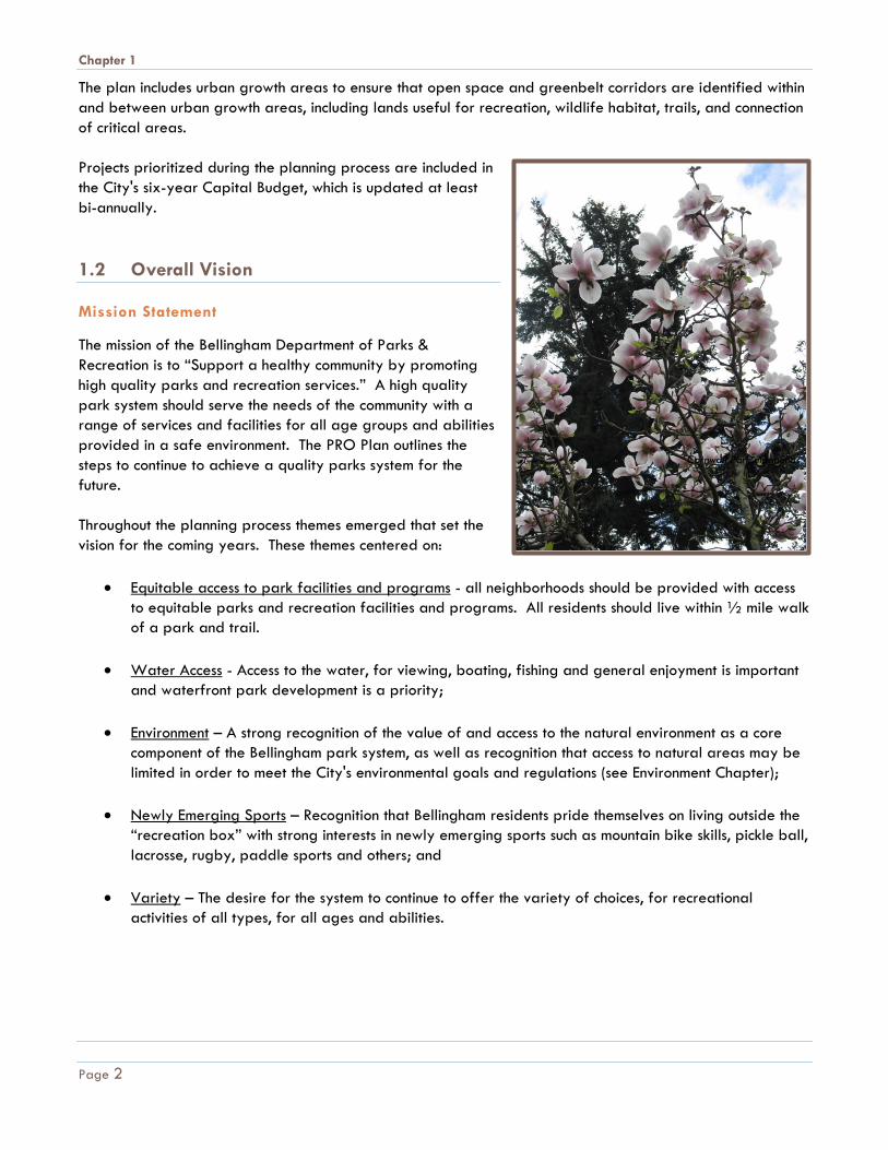
Cornwall Park magnolias
Page 2

Chapter 1
1.3 Previous Plans This PRO Plan, prepared in 2013-2014and updated in 2016, builds on previous comprehensive planning efforts and is an element of the Comprehensive Plan for Bellingham. The PRO Plan considers parks, recreation and open space land, facilities and programs.
Bellingham continues to grow and change as a community. Greater infill development is occurring within the central part of the city, while new development is expected in annex areas. New types of recreation are emerging and activities once considered “extreme” are now “mainstream.” The park system also attracts a greater number of users than ever before and requires more flexibility of park resources to respond to new trends and increased population. 1.4 Objectives & Approach The specific objectives of this planning effort are to:
• Describe the Community Setting – Establish the framework within which park, recreation, and open space facilities should be provided, including natural features, historical context, land use implications, current recreation trends and demographics.
• Inventory the Existing Park System –
This includes lands owned and operated by the city or other public agencies, both within the planning area and beyond. The planning area is defined in section 1.6 of this chapter.
• Analyze Needs & Opportunities – Analyze the needs for future park, recreation, and open space
facilities or programs and develop recommendations, including the necessary resources for meeting and maintaining those needs.
• Establish Goals and Objectives – Identify the goals to be met and objectives to carry out those goals
as the PRO Plan is implemented • Adopt a Level-of-Service – Based on the existing park system and the recommendations of the
community, establish proposed level of service standards and lay the groundwork for revised standards to help guide development of the park system over the next 10 to 20 years.
• Create an Implementation Plan – Establish the overall estimated cost of achieving the proposed level-
of-service, based on the community’s recommendations, prioritize those recommendations, and
Squalicum Creek in Cornwall Park. Photo by Kristen Krussow.
Page 3
Chapter 1
develop a plan to implement the priority recommendations through a six-year Capital Improvement Plan (CIP). In addition, develop general strategies to be considered for the projected population growth over the next 20 years.
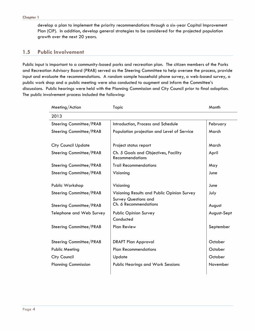
1.5 Public Involvement Public input is important to a community-based parks and recreation plan. The citizen members of the Parks and Recreation Advisory Board (PRAB) served as the Steering Committee to help oversee the process, provide input and evaluate the recommendations. A random sample household phone survey, a web-based survey, a public work shop and a public meeting were also conducted to augment and inform the Committee’s discussions. Public hearings were held with the Planning Commission and City Council prior to final adoption. The public involvement process included the following:
Meeting/Action Topic Month
2013
Steering Committee/PRAB Introduction, Process and Schedule February
Steering Committee/PRAB
Population projection and Level of Service March
City Council Update Project status report March
Steering Committee/PRAB Ch. 5 Goals and Objectives, Facility Recommendations
April
Steering Committee/PRAB Trail Recommendations May
Steering Committee/PRAB Public Workshop
Visioning Visioning
June June
Steering Committee/PRAB Steering Committee/PRAB
Visioning Results and Public Opinion Survey Survey Questions and Ch. 6 Recommendations
July August
Telephone and Web Survey Public Opinion Survey Conducted
August-Sept
Steering Committee/PRAB Plan Review September
Steering Committee/PRAB DRAFT Plan Approval October
Public Meeting Plan Recommendations October
City Council Update October
Planning Commission
Public Hearings and Work Sessions November
Page 4
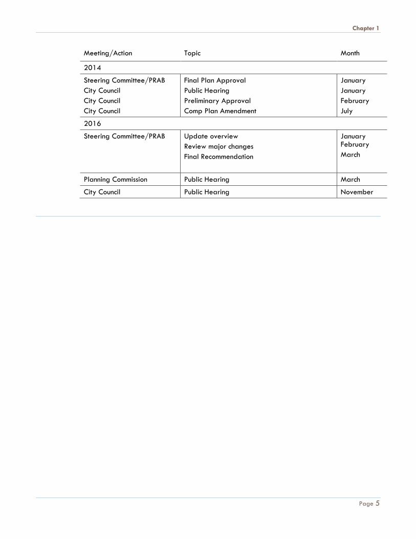
Chapter 1
Meeting/Action
Topic
Month
2014
Steering Committee/PRAB City Council City Council City Council
Final Plan Approval Public Hearing Preliminary Approval Comp Plan Amendment
January January February July
2016
Steering Committee/PRAB Update overview Review major changes Final Recommendation
January February March
Planning Commission Public Hearing March
City Council Public Hearing November
Page 5
Chapter 1
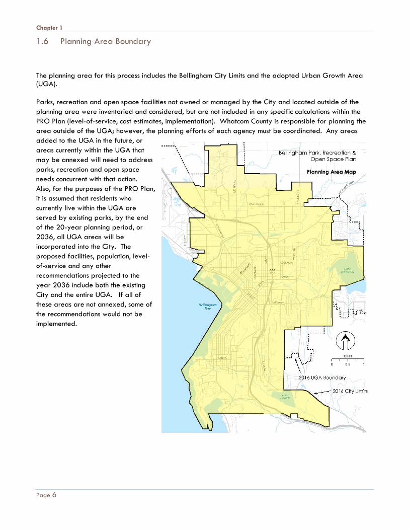
1.6 Planning Area Boundary
The planning area for this process includes the Bellingham City Limits and the adopted Urban Growth Area (UGA). Parks, recreation and open space facilities not owned or managed by the City and located outside of the planning area were inventoried and considered, but are not included in any specific calculations within the PRO Plan (level-of-service, cost estimates, implementation). Whatcom County is responsible for planning the area outside of the UGA; however, the planning efforts of each agency must be coordinated. Any areas added to the UGA in the future, or areas currently within the UGA that may be annexed will need to address parks, recreation and open space needs concurrent with that action. Also, for the purposes of the PRO Plan, it is assumed that residents who currently live within the UGA are served by existing parks, by the end of the 20-year planning period, or 2036, all UGA areas will be incorporated into the City. The proposed facilities, population, level-of-service and any other recommendations projected to the year 2036 include both the existing City and the entire UGA. If all of these areas are not annexed, some of the recommendations would not be implemented.
Page 6
Chapter 1
1.7 Plan Documentation This plan is organized into seven chapters including:
• Introduction and overview;
• Community setting; • Inventory of existing facilities; • Demand for new land and facilities; • Goals and objectives in fulfilling those demands; • Recommendations to meet the demand; • Implementation of the recommendations.
Appendices include:
• Park type classifications;
• Detailed tables of existing and proposed park system facilities;
• North Bellingham Trail Plan;
• Capital Facilities Plan;
• Revenue Source Descriptions; and
• Public opinion survey results.
Page 7
Chapter 2
Chapter 2 C O M M U N I T Y S E T T I N G
2.1 Location, Topography and Climate Bellingham is located in northwest Washington on the shore of Bellingham Bay. The inland urban area is framed by the slopes of Stewart, Lookout, and Chuckanut Mountains, at the edge of the Cascade foothills with Mount Baker in the background.
Topography ranges from sea level to about 500 feet on the hilltops around Bellingham. Elevation increases to 3,050 feet at the top of Stewart Mountain, and eventually to 10,785 at the top of Mount Baker. The landform is generally flat to rolling within the urban growth area, though the plateau edge overlooking Bellingham Bay can drop off abruptly in slopes ranging from 40% to 75%.
Bellingham has a mild maritime climate. Mean temperatures vary from a high of 73 degrees in July to a low of 31 degrees Fahrenheit in January. Average annual precipitation is about 35 inches. Approximately 80% of the precipitation occurs from October through March with less than 6% falling during the summer months.
2.2 Natural Features Bellingham citizens are blessed with living in an area of incredible natural beauty and have a long legacy of placing high value on the environment. The first Greenway Levy passed largely in response to citizen interest in protecting valuable wildlife habitat corridors, shoreline, riparian, wetland and unique upland areas and providing public access to those unique areas.
In 2005, Bellingham strengthened protection of wetland and streams by adopting the Critical Areas Ordinance which also protects steep slopes and frequently flooded areas. The Shoreline Master Program (SMP) was updated in 2013, adding more protection for shorelines and providing habitat restoration guidance while supporting public access.
Nestled between the
mountains and the sea in
northwest Washington
State, Bellingham is at the
center of a uniquely
picturesque area offering
a rich variety of
recreational, cultural,
educational and economic
activities.
Page 8

Chapter 2
In 2012, the City Council adopted a new Environment Element (Chapter 9) of the Comprehensive Plan to address environmental protection and ensure compliance with the Growth Management Act (GMA).
The City recently developed a Habitat Restoration Technical Assessment and a marine nearshore assessment. The plan uses a science-based prioritization framework to guide the preservation, restoration, and recovery of the City's terrestrial, aquatic and riparian habitats.
Enhancing and preserving existing habitats supports the City's adopted legacies regarding Clean, Safe Drinking Water and a Healthy Environment.
Following is a list of important environmental features with public recreation elements in and around the Bellingham area.
2.2.1 Creeks
Three major creeks and multiple minor creeks drain the Bellingham area. Squalicum, Whatcom, and Padden Creeks and tributaries are on the Washington State list of impaired water bodies. Preventing further degradation and improving water quality of the City's creeks is important to ensure the resources they provide to the community are protected. • Squalicum Creek – A major creek that starts at Squalicum Lake and flows southwest to the mouth of Bellingham Bay. The Bay to Baker Trail is planned within the Squalicum Creek Greenway Corridor.
• Whatcom Creek – A major creek that drains from the northwest end of Lake Whatcom west into Bellingham Bay. Whatcom Creek Trail and Greenway generally follows the alignment of Whatcom Creek.
• Padden Creek – A major creek that drains from the Lake Padden west into Bellingham Bay. Upper and lower Padden Creek Greenway Trail follows the corridor.
• Little Squalicum Creek - A perennial stream northwest of Squalicum Creek that flows through Little Squalicum Park and into Bellingham Bay.
• Connelly Creek – A perennial stream that drains south from Sehome Hill into Padden Creek. The 26 acre Connelly Creek Nature Area preserves valuable habitat and provides walking trails.
• Chuckanut Creek – A perennial stream that drains from near Lake Samish west into Chuckanut Bay, through Arroyo Park.
Whatcom Creek in Whatcom Falls Park
Page 9
Chapter 2
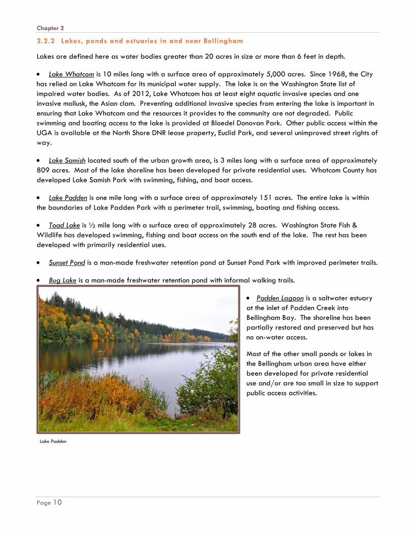
2.2.2 Lakes, ponds and estuaries in and near Bellingham
Lakes are defined here as water bodies greater than 20 acres in size or more than 6 feet in depth.
• Lake Whatcom is 10 miles long with a surface area of approximately 5,000 acres. Since 1968, the City has relied on Lake Whatcom for its municipal water supply. The lake is on the Washington State list of impaired water bodies. As of 2012, Lake Whatcom has at least eight aquatic invasive species and one invasive mollusk, the Asian clam. Preventing additional invasive species from entering the lake is important in ensuring that Lake Whatcom and the resources it provides to the community are not degraded. Public swimming and boating access to the lake is provided at Bloedel Donovan Park. Other public access within the UGA is available at the North Shore DNR lease property, Euclid Park, and several unimproved street rights of way.
• Lake Samish located south of the urban growth area, is 3 miles long with a surface area of approximately 809 acres. Most of the lake shoreline has been developed for private residential uses. Whatcom County has developed Lake Samish Park with swimming, fishing, and boat access.
• Lake Padden is one mile long with a surface area of approximately 151 acres. The entire lake is within the boundaries of Lake Padden Park with a perimeter trail, swimming, boating and fishing access.
• Toad Lake is ½ mile long with a surface area of approximately 28 acres. Washington State Fish & Wildlife has developed swimming, fishing and boat access on the south end of the lake. The rest has been developed with primarily residential uses.
• Sunset Pond is a man-made freshwater retention pond at Sunset Pond Park with improved perimeter trails.
• Bug Lake is a man-made freshwater retention pond with informal walking trails.
• Padden Lagoon is a saltwater estuary at the inlet of Padden Creek into Bellingham Bay. The shoreline has been partially restored and preserved but has no on-water access.
Most of the other small ponds or lakes in the Bellingham urban area have either been developed for private residential use and/or are too small in size to support public access activities.
Lake Padden
Page 10

Chapter 2
2.3 Park Development in Sensitive Areas Intense park activities should be separated from sensitive areas by maintaining and enhancing buffers to protect habitat function. Access to select sensitive areas may be provided through low impact trails, only when public access does not impair ecological function. Where appropriate and consistent with City goals and policies, the PRO Plan should identify areas to preserve and enhance for open space and other low impact or no impact park uses, in recognition of the fact that open spaces are set aside for preservation of natural buffers (See Section 3.1.4). Mature shoreline trees, snags, and downed logs should be preserved where possible to allow wildlife species to coexist in urban areas. When preserving or enhancing natural areas, the City should:
• Limit – harmful activities • Remove – invasive plant species that displace native materials and habitat, • Plant – native trees and shrubs that support and retain native wildlife species, and • Cluster – park improvements to preserve natural shorelines and contiguous open spaces for wildlife habitat.
2.4 Historical Development Lummi, Nooksack, and Samish Indians lived in and around the Nooksack River and Bellingham Bay area. These tribes fished in saltwater and the river. The tribes also exhibited some agricultural and hunting characteristics common to eastern or interior tribes. Village sites were located along Bellingham Bay and the Nooksack River. In 1792, the first western exploration of Puget Sound was accomplished by British explorer Captain George Vancouver. Vancouver charted Bellingham Bay and named it in honor of Sir William Bellingham, Controller of the British Navy. In 1852, Henry Roeder and Russell Peabody arrived from California and started the Roeder-Peabody-Page sawmill on Whatcom Creek Waterway to process virgin red cedar and Douglas fir. By 1854, the towns of Whatcom, Sehome, Bellingham, and Fairhaven were settled around Bellingham Bay; the Washington Territorial Legislature established Whatcom County and the county seat. Whatcom was derived from an Indian term meaning “rough tumbling waters” – a reference to lower Whatcom Falls. In 1903, the towns of Whatcom, Sehome, Bellingham, and Fairhaven were consolidated into the City of Bellingham. Tideland areas were filled and the Great Northern Railway constructed passenger and freight
Whatcom Falls. Courtesy of Whatcom Museum archives.
Page 11

Chapter 2
depots in the Whatcom "Old Town" business district to service the rapidly expanding city. As Bellingham continued to expand the core business district gradually moved onto the hill overlooking Whatcom Creek and Bellingham Bay.
2.5 Population 2.5.1 Population Trends
The 2015 population for Bellingham was estimated to be 83,580. Bellingham’s official census population for 2000 was estimated to be 67,171 resulting in an average annual increase of 1.47% per year over the 15 year period. The unincorporated Urban Growth Area (UGA) for Bellingham has an estimated 10,360 people for a total UGA population of 93,940 in the year 2015.
2.5.2 Population Projections
According to the 2016 Whatcom County Comprehensive Plan, the City’s population will increase to 124,157 persons by the year 2036 assuming all UGA areas are incorporated, or by another 30,217 people from the 2015 population. This is equal to an annual average increase of 2% per year over the 20 year period.
2.6 Demographics The following demographic information was taken from the United States Census 2007-2011 and 2010-2014 five-year average American Community Survey Demographic Profiles for Bellingham. Demographics are important to consider in reviewing various opportunities for specific recreation proposals or in evaluating new trends or interests in recreation programming or facilities.
TABLE 2.6.1
Economic Characteristics
Census Year 2007-2011 ACS 2010-2014 ACS
Mean travel time to work in minutes 17.7 17.6
Median household income* $ 39,299 $42,440
Median family income* $ 61,051 $63,355
Per capita income* $ 24,396 $24,864
Families below poverty level 10.7% 14.0%
* all income listed is in inflation-adjusted dollars
2015 City Population = 83,580
2015 UGA Population = 10,360
2015 Total Population = 93,940
2036 Projected Population = 124,157
Page 12
Chapter 2
TABLE 2.6.2
Housing Characteristics
Census Year 2007-2011 ACS 2010-2014 ACS
Occupied Housing Units 93% 93.4%
Vacant Housing Units 7% 6.6%
Owner-occupied Housing Units 45.8% 45.7%
Renter-occupied Housing Units 54.2% 54.3%
TABLE 2.6.3
Age Characteristics
Census Year 2007-2011 ACS 2010-2014 ACS
Median Age 30.6 31.0
Under 5 years 4.8% 5.0%
5 to 19 Years 17.1% 17.0%
20 to 34 Years 33.5% 33.1%
35 to 64 Years 32.2% 31.6%
65 Years and Over 12.4% 13.2%
TABLE 2.6.4
Ethnic Characteristics
Census Year 2007-2011 ACS 2010-2014 ACS
White 86.6% 84.8%
Hispanic or Latino 7.3% 8.3%
Black or African American 1.4% 1.1%
Asian 4.8% 5.3%
American Indian and Alaska Native 1.7% 1.8%
Native Hawaiian and Other Pacific Islander 0.1% 0.1%
Two or More Races 3.3% 4.7%
Other 2.1% 2.2%
Language other than English at home 11.9% 12.8%
Page 13

Chapter 2
TABLE 2.6.5
Physically Impaired Population
Census Year 2007-2011 ACS 2010-2014 ACS
Disability Status 3.0% 5.1%
Ambulatory Difficulty 2.0% 3.8%
Vision Difficulty 2.2% 3.9%
2.7 Recreation Trends
Similar to the rest of Washington State, Bellingham has seen a steady increase in organized sports. In Bellingham, that increase has also included new types of activities, such as pickle ball, rugby, lacrosse, ultimate Frisbee and disc golf. There is also an increased interest in emerging sports, such as mountain bike skills, paddle boarding and rock climbing. A changing demographic and an increase in cultural diversity in the Bellingham area have brought new types of interests in recreational activities and programs. It has also brought a greater need for more general recreational activities and financial assistance to residents where needed for recreational program or facility fees. Similar to trends across the nation, Bellingham residents continue to demand more off road walking and bicycling trails. As trails increase in popularity and the community grows, there are conflicts among trail users, with a high increase of dogs off leash in undesignated areas. The census data also shows that, much like the rest of the nation, Bellingham's population is aging with the percent of the population over 65 years of age increasing from 12.4% in 2011 to 13.2% in 2014. Ensuring that parks facilities are accessible for those with limited mobility will be key in ensuring our goals of access for all groups in our community. Nationally, there has been recognition of the importance of recreation and park systems to overall quality of life, health and well-being especially as related to the growing obesity rate across the nation. Research shows that well-designed and accessible parks and open spaces are correlated with better physical health, through increased rates of physical activity, and with many mental health benefits, such as lower rates of depression and stress. Establishing a level of service for parks and trails that ensures equal equitable access and proximity for all populations within the community is an important step towards addressing health disparities and promoting good health for all. Using a community and network based approach to park planning more clearly indicates gaps in services and facilities. The community-based approach is discussed in more detail in Chapter 4 of the PRO Plan.
Disc Golf at Cornwall Park. Photo by Colin Morris.
Page 14
Chapter 3
Chapter 3 E X I S T I N G F A C I L I T I E S
An extensive network of park, recreation and open space facilities is provided by the City and other agencies including County, School District, Port and State and is available to Bellingham citizens. The inventory of existing facilities is organized into all those that are owned or managed by the City along with other agency facilities available to the general public within the City/UGA planning area. These are included in the City’s level-of-service metrics. Non-City facilities that are located outside of the planning area but enhance the local recreation experience are inventoried to demonstrate the availability of additional recreational amenities in the area, but they are not included in the level of service. Level-of-service (LOS) is further defined in Chapter 4 of the PRO Plan. School facilities provide an additional public benefit but are not included in the level-of-service as they are not available to the general public on a regular basis. 3.1 Facility Inventory Classifications The inventory of existing facilities is divided into the following park classifications:
• Neighborhood Park • Community Park • Special Use Sites • Open Space • Trails Each classification is described below, along with a map locating and identifying each facility. A detailed inventory of recreation activities within each facility, organized by ownership and classification, is also included in Appendix B of the PRO Plan. A more detailed description of each park classification type, including approximate size, service area, development, and acquisition guidelines is included in Appendix A of the PRO Plan. 3.1.1 Neighborhood Park (NP)
Neighborhood parks are the basic recreational focus and center of neighborhoods. They should be developed with both active and passive recreation activities and serve those living within a half mile
"The nation behaves well
if it treats its natural
resources as assets which
it must turn over to the
next generation
increased, and not
impaired, in value."
- Theodore Roosevelt
Page 15
Chapter 3
walk along a designated pedestrian route, sidewalk or trail. Neighborhood parks should accommodate a wide variety of age and user groups, including youth, adults, seniors and special needs populations. Creating a sense of place by bringing together the unique character of the site with that of the neighborhood is vital to a successful neighborhood park.
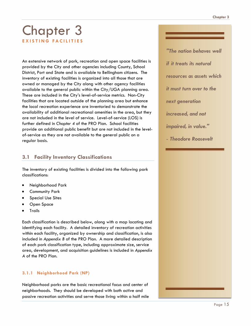
3.1.2 Community Park (CP)
Community parks are generally larger than neighborhood parks and are intended to serve a broader range of activities and users. Their focus is on meeting the recreation needs of the larger community with more specialized activities, as well as preserving unique landscapes, open spaces or environmental features. They allow for group activities and offer other recreation opportunities, such as lighted programmed sports facilities not generally found at the neighborhood level. Due to their larger size, they are often designed to serve both as a neighborhood park function as well as having expanded and unique activities. Community parks should be distributed throughout the City with approximately one park for every four square miles, and served by designated pedestrian routes, sidewalks or trails.
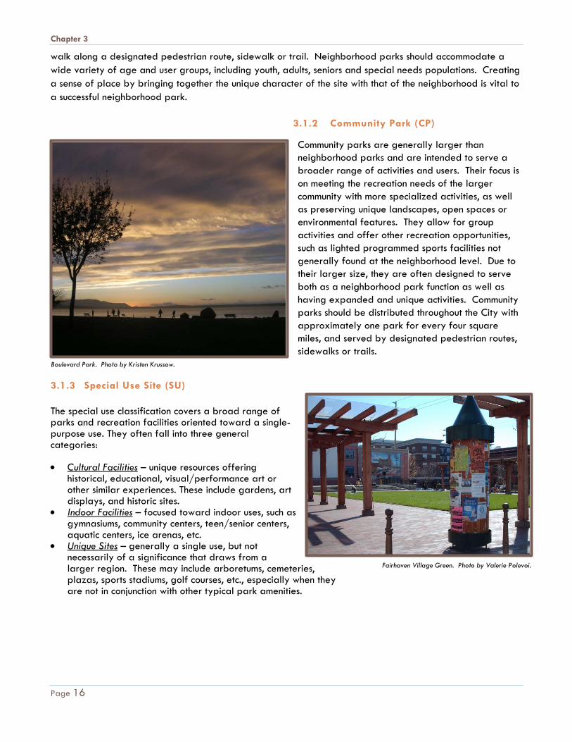
3.1.3 Special Use Site (SU) The special use classification covers a broad range of parks and recreation facilities oriented toward a single-purpose use. They often fall into three general categories: • Cultural Facilities – unique resources offering
historical, educational, visual/performance art or other similar experiences. These include gardens, art displays, and historic sites.
• Indoor Facilities – focused toward indoor uses, such as gymnasiums, community centers, teen/senior centers, aquatic centers, ice arenas, etc.
• Unique Sites – generally a single use, but not necessarily of a significance that draws from a larger region. These may include arboretums, cemeteries, plazas, sports stadiums, golf courses, etc., especially when they are not in conjunction with other typical park amenities.
Boulevard Park. Photo by Kristen Krussow.
Fairhaven Village Green. Photo by Valerie Polevoi.
Page 16

Chapter 3
EXISTING FACILITIES PLAN • PARKS AND SPECIAL USE SITES
Community Parks
a. Bloedel Donovan Park b. Boulevard Park c. Civic Athletic Complex d. Cordata Community Park e. Cornwall Park f. Cornwall Beach Park g. Fairhaven Park h. Lake Padden Park i. Marine Port (Port) j. Maritime Heritage Park k. Northridge Park l. Squalicum Creek Park m. Van Wyck Park n. Whatcom Falls Park o. Whatcom Waterway Park p. Zuanich Point Park (Port)
Neighborhood Parks 1. Birchwood Park 2. Broadway Park 3. Carl Lobe Park 4. Cordata Park 5. Cornwall Tot Lot 6. Elizabeth Park 7. Fairhaven Village Green 8. Forest & Cedar Park 9. Fouts Park 10. Harriet Spanel Park 11. Happy Valley Park 12. Highland Heights Park 13. Laurel Park 14. Lorraine Ellis Park 15. Maplewood McLeod 16. Memorial Park 17. N. Samish Crest Park 18. Ridgemont Park 19. Rock Hill Park 20. Roosevelt Park 21. S. Samish Crest Park 22. Shuksan Meadows Park 23. St. Clair Park 24. Sunnyland Park 25. Sunset Pond Park 26. Ted Edwards Park (County)
Special Use Sites 27. Bayview Cemetery 28. Big Rock Garden 29. Cornwall Rose Garden 30. Lake Padden Golf Course 31. Woodstock Farm
Page 17
Chapter 3
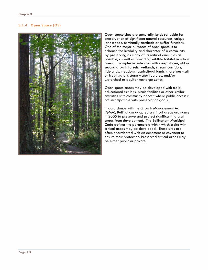
3.1.4 Open Space (OS)
Open space sites are generally lands set aside for preservation of significant natural resources, unique landscapes, or visually aesthetic or buffer functions. One of the major purposes of open space is to enhance the livability and character of a community by preserving as many of its natural amenities as possible, as well as providing wildlife habitat in urban areas. Examples include sites with steep slopes, old or second growth forests, wetlands, stream corridors, tidelands, meadows, agricultural lands, shorelines (salt or fresh water), storm water features, and/or watershed or aquifer recharge zones. Open space areas may be developed with trails, educational exhibits, picnic facilities or other similar activities with community benefit where public access is not incompatible with preservation goals. In accordance with the Growth Management Act (GMA), Bellingham adopted a critical areas ordinance in 2005 to preserve and protect significant natural areas from development. The Bellingham Municipal Code defines the parameters within which a site with critical areas may be developed. These sites are often encumbered with an easement or covenant to ensure their protection. Preserved critical areas may be either public or private.
Page 18

Chapter 3
EXISTING FACILITIES PLAN • OPEN SPACE
Open Space
1. Arroyo Nature Area 2. Bakerview Open Space 3. Barkley Greenway & Trail 4. Bay to Baker Greenway 5. Bear Creek Greenway 6. Big Rock Open Space 7. Cemetery Creek Greenway 8. Chuckanut Bay Open Space
& Tidelands 9. Connelly Creek Nature Area 10. Cordata Open Space 11. East Meadow 12. Euclid Park (City & County) 13. Galbraith Open Space (City
& County) 14. Hawley Open Space 15. Interurban Greenway &
Trail 16. King & Queen Mountain
Open Space 17. Klipsun Greenway & Trail 18. Lazy E Ranch Open Space 19. Little Squalicum Park 20. Lowell Park Open Space 21. Lower Padden Creek Open
Space & Trails 22. North Bay Open Space (City
& Port 23. Orchard Estates Wetlands 24. Padden Gorge 25. Post Point Treatment Plant
Open Space (Public Works) 26. Railroad Greenway & Trail 27. Salmon Woods Open Space 28. Samish Crest Open Space 29. Sehome Hill Arboretum 30. Silver Creek Open Space 31. South Bay Greenway & Trail 32. South Samish Crest Open
Space 33. Spring Creek Nature Area 34. Squalicum Creek Greenway 35. Whatcom Creek Greenway
& Trail 36. Lake Geneva (watershed) 37. Laplante (watershed) 38. Macate & Wells (watershed) 39. Oriental Creek (watershed) 40. Silver Beach (watershed) 41. Strode (watershed) 42. Zarnowitz (watershed) 43. Alderwood Open Space
(County) 44. Chuckanut Mountains
(County)
Page 19
Chapter 3
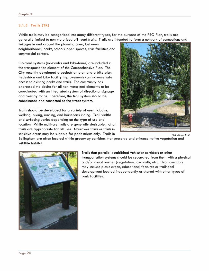
3.1.5 Trails (TR) While trails may be categorized into many different types, for the purpose of the PRO Plan, trails are generally limited to non-motorized off-road trails. Trails are intended to form a network of connections and linkages in and around the planning area, between neighborhoods, parks, schools, open spaces, civic facilities and commercial centers. On-road systems (sidewalks and bike-lanes) are included in the transportation element of the Comprehensive Plan. The City recently developed a pedestrian plan and a bike plan. Pedestrian and bike facility improvements can increase safe access to existing parks and trails. The community has expressed the desire for all non-motorized elements to be coordinated with an integrated system of directional signage and overlay maps. Therefore, the trail system should be coordinated and connected to the street system. Trails should be developed for a variety of uses including walking, biking, running, and horseback riding. Trail widths and surfacing varies depending on the type of use and location. While multi-use trails are generally desirable, not all trails are appropriate for all uses. Narrower trails or trails in sensitive areas may be suitable for pedestrians only. Trails in Bellingham are often located within greenway corridors that preserve and enhance native vegetation and wildlife habitat.
Trails that parallel established vehicular corridors or other transportation systems should be separated from them with a physical and/or visual barrier (vegetation, low walls, etc.). Trail corridors may include picnic areas, educational features or trailhead development located independently or shared with other types of park facilities.
Old Village Trail
Page 20
Chapter 3
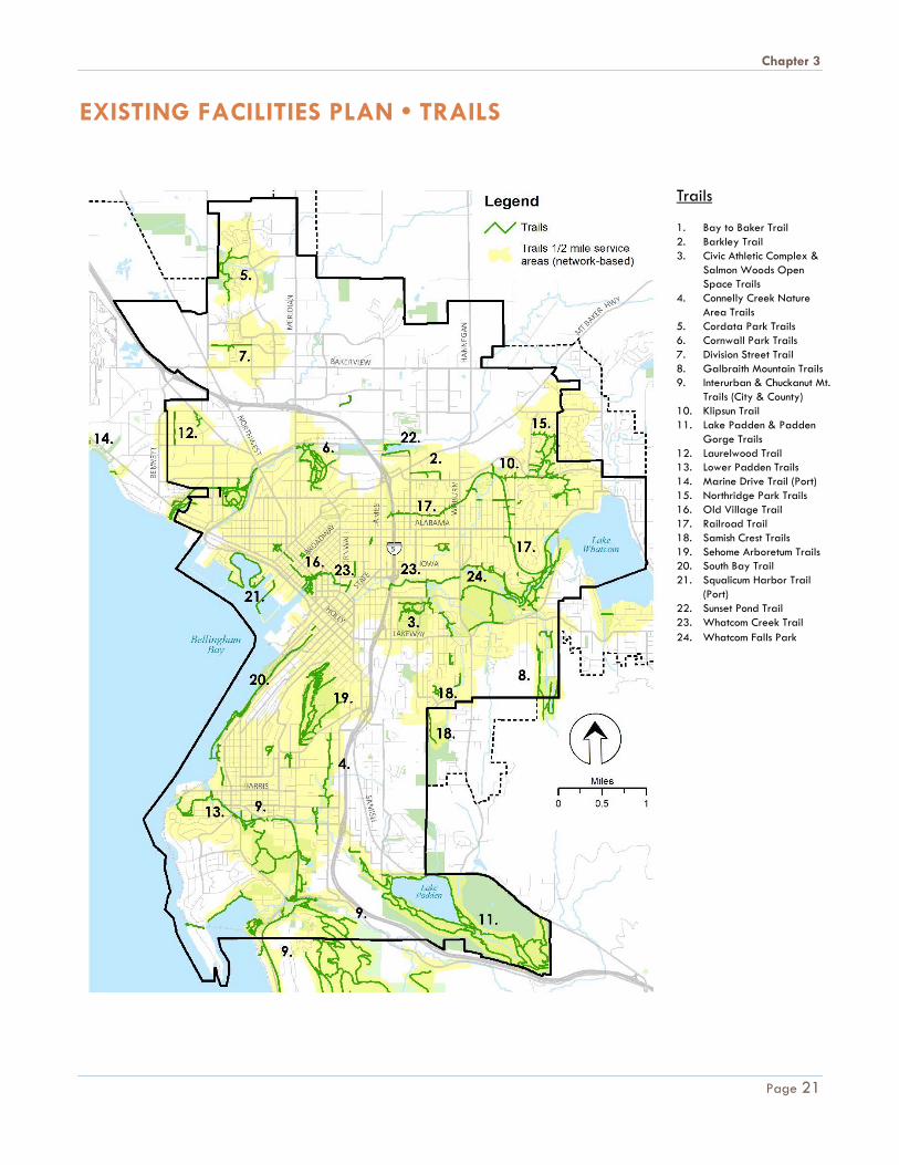
EXISTING FACILITIES PLAN • TRAILS
Trails 1. Bay to Baker Trail 2. Barkley Trail 3. Civic Athletic Complex &
Salmon Woods Open Space Trails
4. Connelly Creek Nature Area Trails
5. Cordata Park Trails 6. Cornwall Park Trails 7. Division Street Trail 8. Galbraith Mountain Trails 9. Interurban & Chuckanut Mt.
Trails (City & County) 10. Klipsun Trail 11. Lake Padden & Padden
Gorge Trails 12. Laurelwood Trail 13. Lower Padden Trails 14. Marine Drive Trail (Port) 15. Northridge Park Trails 16. Old Village Trail 17. Railroad Trail 18. Samish Crest Trails 19. Sehome Arboretum Trails 20. South Bay Trail 21. Squalicum Harbor Trail
(Port) 22. Sunset Pond Trail 23. Whatcom Creek Trail 24. Whatcom Falls Park
Page 21
Chapter 3
3.2 Outside the Planning Area An inventory of existing facilities owned or managed by other agencies outside the planning area is listed in Appendix B of the PRO Plan. These facilities are not included in the level-of-service metrics or cost estimates associated with the PRO Plan. They are listed for reference only. They were considered during the planning process as facilities that provide additional service to area residents in the overall evaluation of opportunities available in the area. Ownership of these facilities includes: • Washington State (WS)
o Parks Department o Department of Natural Resources o Department of Fish & Wildlife
• Whatcom County (WC) Also included in this category are existing school-owned facilities. Since these facilities are available on a limited basis during non-school hours, they are not included in the City’s overall level-of-service metrics, but are considered when evaluating neighborhood amenities. s. The schools include: • Bellingham School District (BSD) • Whatcom Community College (WCC) • Bellingham Technical College (BTC) • Western Washington University (WWU)
Page 22

Chapter 4
Chapter 4 L A N D A N D F A C I L I T Y D E M A N D
Level-of-service (LOS) standards for park, recreation, and open space land and facilities can help a community plan and budget for the demands of a growing and changing population. This plan used a community-based approach to develop specific land and facility demands through the 20 year planning period, or 2036. Utilizing this approach allowed the citizens of Bellingham to influence the process through public meetings and surveys in which they were asked to evaluate the existing system and express demand for additional facilities. Level-of-service is expressed several ways in this plan: the proximity of facilities to the population (service area), as a ratio of land to the population (acres per 1,000 people), and an overall system dollar value per capita. The process considered the community-expressed interests and needs for a park system and the plan recommendations were based on these preferences. 4.1 Service Area LOS Parks levels of service may be measured in a multitude of ways, including quantity of acres per person, walking distance proximity to parks and trails, pubic satisfaction with facilities, participation in parks programs, costs to maintain the park system, and facility service areas. The City is developing additional tools to better understand level of service. These tools will help assess existing access in all neighborhoods, and provide data to prioritize where additional resources are needed, including programing, development of new facilities, maintenance of existing facilities and land acquisition. These new tools are: 1) A complete assessment and inventory that evaluates the facilities and amenities in each of the City's parks, and 2) Data and analysis to evaluate equity and distribution of park facilities using income, population density, and other demographic characteristics.
A community-based approach is recommended to respond
to the needs, values and goals specific to Bellingham.
A community-based
level-of-service is used in
this process to more
accurately depict local
values, interests and
populations.
Page 23

Chapter 4
Citizens desire easy access to park and recreation facilities with equitable distribution across the community. The City has adopted a goal that every resident live within a one half mile walk for both a park and a trail. The recommendations in this plan were developed with this level-of-service goal in mind. The Port of Bellingham and Whatcom County provide additional land for park, recreation and open space within the UGA planning area that is included in the service area LOS. School facilities are not included in the service area LOS as they are not always available, but are considered when determining the facilities available to a neighborhood. Non City owned facilities outside the urban growth area (and therefore not part of the City’s purview,) are not included in the area LOS but are inventoried in Appendix B. Other major recreational areas, such as the Mount Baker National Recreation Area, North Cascades National Park, and Mount Baker National Forest, also provide a variety of recreational opportunities at a more regional level. 4.2 Population Ratio LOS The demand for park, recreation and open space is often estimated using a ratio of a facility to a unit of population, such as 19 acres of community parks per 1,000 residents. The ratio method is relatively simple to compute and can be compared with national or local park, recreation and open space measurements. The National Recreation & Park Association (NRPA) recognizes the limitations of the population ratio methodology first developed in 1930 and since 1996 has recommended a community-based ratio be developed to reflect the specific conditions and unique nature of each community The existing ratio of land to population level-of-service standard uses existing population estimates from the average American Community Survey Demographic Profiles. The ratio is calculated by dividing the total City or UGA acres of land in each park classification by the respective population. The same calculation is used for existing or proposed (existing acres divided by existing population and proposed acres divided by proposed population) as expressed per 1,000 people. UGA population includes both the City and UGA 2015 estimated populations. The plan recognizes residents of the unincorporated UGA are already using existing parks and are therefore included in calculating the existing land ratio of acres/1,000. This is detailed in Table 4.5.1.
Community input meeting at Bloedel Donovan Park
Page 24
Chapter 4
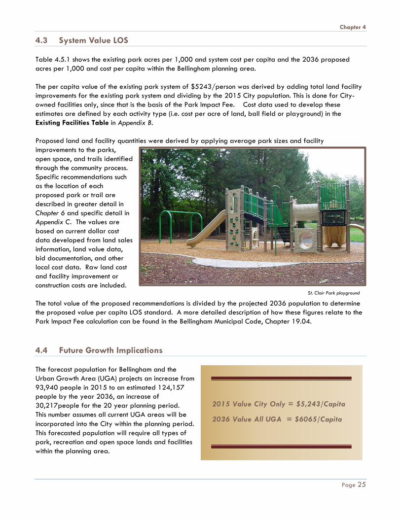
4.3 System Value LOS Table 4.5.1 shows the existing park acres per 1,000 and system cost per capita and the 2036 proposed acres per 1,000 and cost per capita within the Bellingham planning area. The per capita value of the existing park system of $5243/person was derived by adding total land facility improvements for the existing park system and dividing by the 2015 City population. This is done for City-owned facilities only, since that is the basis of the Park Impact Fee. Cost data used to develop these estimates are defined by each activity type (i.e. cost per acre of land, ball field or playground) in the Existing Facilities Table in Appendix B. Proposed land and facility quantities were derived by applying average park sizes and facility improvements to the parks, open space, and trails identified through the community process. Specific recommendations such as the location of each proposed park or trail are described in greater detail in Chapter 6 and specific detail in Appendix C. The values are based on current dollar cost data developed from land sales information, land value data, bid documentation, and other local cost data. Raw land cost and facility improvement or construction costs are included. The total value of the proposed recommendations is divided by the projected 2036 population to determine the proposed value per capita LOS standard. A more detailed description of how these figures relate to the Park Impact Fee calculation can be found in the Bellingham Municipal Code, Chapter 19.04. 4.4 Future Growth Implications The forecast population for Bellingham and the Urban Growth Area (UGA) projects an increase from 93,940 people in 2015 to an estimated 124,157 people by the year 2036, an increase of 30,217people for the 20 year planning period. This number assumes all current UGA areas will be incorporated into the City within the planning period. This forecasted population will require all types of park, recreation and open space lands and facilities within the planning area.
2015 Value City Only = $5,243/Capita
2036 Value All UGA = $6065/Capita
St. Clair Park playground
Page 25
Chapter 4
4.5 Conclusions Over the 20 year planning period, residents should not experience a noticeable reduction in the level of service for parks. The proposed recommendations, if implemented, require the addition of approximately 203 acres of land for neighborhood and community parks, special use sites, trails and open space. Although the overall land acreage ratio is expected to decrease, more of the population will live within a one-half mile walk of a park and a trail. The recommendations, if implemented will provide a balance of passive and active recreational opportunities that are well distributed throughout the community. Special use sites and open space often reflect unique opportunities and environments and may not be equally distributed by neighborhood throughout the community. Since the PRO Plan is updated every six years, the growth, cost and budget implications can be monitored and adjusted based on revised community preferences and population projections with the 2020 plan update. The City can use community input provided during the regular six-year PRO Plan updates in combination with new LOS tools and population forecasts to adequately plan for future growth. If the proposed recommendations are not implemented the City may experience a loss of public accessibility and lack of preservation of more sensitive and appealing environmental sites, particularly within the developing urban growth areas and could preclude the purchase and development of, suitable lands for active recreation, such as playgrounds, picnic shelters, athletic fields and courts, and other land-intensive recreational facilities. This may result in crowding of existing recreational facilities, and reduce the availability of organized programs requiring travel to other jurisdictions outside the planning area to meet the demand. The following Table 4.5.1 shows a comparison between the existing and 2036 proposed population and acres per 1,000 population if the recommendations are implemented.
Page 26

Chapter 4
TABLE 4.5.1
2015 CITY Estimated Population 83,580
2015 UGA Estimated Population 93,940
2036 UGA Projected Population 124,157
Ownership
Tota
l Lan
d (a
cres
)
Nei
ghbo
rhoo
d Pa
rk (a
cres
)
Com
mun
ity
Park
(acr
es)
Spec
ial U
se
Park
(acr
es)
Ope
n Sp
ace
/ Tr
ail (
acre
s)
Tot
al P
ark
Syst
em
Val
ue/C
apita
*
EXISTING PARK SYSTEM ACRES - CITY & UGA
City of Bellingham 3400.8 78.6 1582.9 305.6 1433.7 $5,243
City Watershed 241.7 241.7
Port of Bellingham (UGA) 37.2 7.9 4.3 25 n/a
Whatcom County (UGA) 131.1 6.7 1.5 122.9 n/a
TOTAL EXISTING UGA 3810.8 85.3 1590.8 311.4 1823.3 n/a
PROPOSED PARK SYSTEM ADDITION ACRES - CITY & UGA*
City of Bellingham (UGA) 203.2 36 5 1.5 160.7 $822
City Watershed (UGA) n/a
Port of Bellingham (UGA) n/a
Whatcom County (UGA) n/a
TOTAL PROPOSED CITY & UGA ACRES BY YEAR 2036 4,014 121.3 1,595.8 312.9 1984
PARK SYSTEM STANDARD - CITY & UGA
2015 CITY Existing / 1000 45.6 1.02 19.03 3.7 21.8 $5,243
2015 City + UGA Standard/ 1000
40.6 0.9 16.9 3.3 19.4 n/a
2036 City + UGA Standard /1000
32.3 .97 12.9 2.5 15.98 $6,065
NRPA LOS Standard/ 1000 34.5 2.0 8.0 n/a 6.0
* Park system values includes land and facility value. See Appendix B of the PRO Plan for facility cost details
Page 27
Chapter 5
Chapter 5 G O A L S A N D O B J E C T I V E S
The mission of the Bellingham Department of Parks & Recreation is to “Support a healthy community by providing high quality parks and recreation services.” The following goals and objectives of the Parks and Recreation Department have been organized under the Bellingham City Council Legacies and Strategic Commitments which were adopted in 2009 to ensure that future generations will benefit from the work being done today. Goals are broad statements of intent that describe a desired outcome. Objectives, on the other hand, are both measurable and specific. Objectives help define when a goal has been met. 5.1 Council Legacy: Sense of Place Council Strategic Commitments • Support sense of place in neighborhoods • Encourage development within existing infrastructure • Preserve historic & cultural resources • Protect natural green settings & access to open space • Support people-to-people connections Parks and Recreation Related Goals and Objectives 5.1.1 GOAL Provide a high quality, parks, recreation and open space system for a diversity of age and interest groups. 5.1.1.1 OBJECTIVES A. Provide Neighborhood and Community Parks.
a. Provide a system of neighborhood and community parks so that all residents live within one half mile safe walking distance of a developed park.
b. Emphasize acquisition and development of parks in underserved areas.
c. Provide equitable access to parks with activities for all age groups and abilities, distributed throughout the community.
Bellingham City Council
Legacies and Strategic
Commitments:
"We are working today so
future generations will benefit
from:
• Clean, Safe Drinking
Water
• Healthy Environment
• Vibrant Sustainable
Economy
• Sense of Place
• Safe & Prepared
Community
• Mobility & Connectivity
Options
• Access to Qualify of Life
Amenities
• Quality, Responsive City
Services
• Equity & Social Justice"
Page 28
Chapter 5
d. Add capacity to existing parks by expanding facilities or adding land to accommodate increased population.
e. Identify potential park opportunities in redeveloping areas, including depressed commercial or economic centers.
f. Coordinate with other City departments, public and private agencies and private landowners to set aside land and resources on the most suitable sites.
g. Acquire additional shoreline access where appropriate for waterside trails, waterfront fishing, wading, swimming, boating and other water related recreational activities.
h. Develop athletic facilities that meet the playing standards and requirements for all age groups, skill levels, and recreational interests.
i. Provide a mix of court and field activities like skateboard, basketball, tennis, volleyball, soccer, baseball, and softball that provide for a variety of user groups placed equitably throughout the City and near transit corridors for ease of access.
j. In conjunction with the Bellingham School District, Western Washington University, Whatcom Community College and other public and private agencies, develop a select number of facilities that provide the highest competitive playing standard.
k. Develop new or improved multi-use facilities to increase flexibility of use for new activities such as pickle ball, disc golf, lacrosse, cricket, rugby, parkour or other new recreation trends as demonstrated by community need.
l. Where appropriate and as funding is available, incorporate art into park facilities such as railings, benches, buildings and other park amenities.
m. Provide adequate funding and staff for operation and maintenance to ensure safe, serviceable, and functional parks and facilities.
B. Provide Special Use Sites.
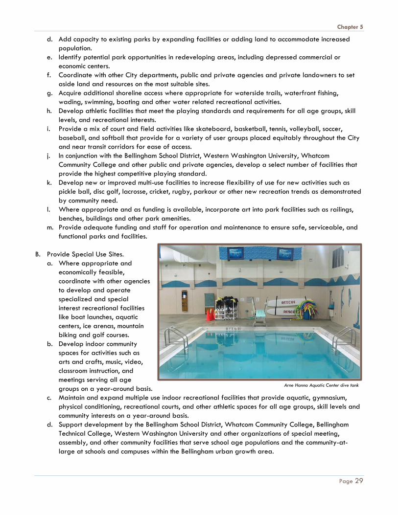
a. Where appropriate and economically feasible, coordinate with other agencies to develop and operate specialized and special interest recreational facilities like boat launches, aquatic centers, ice arenas, mountain biking and golf courses.
b. Develop indoor community spaces for activities such as arts and crafts, music, video, classroom instruction, and meetings serving all age groups on a year-around basis.
c. Maintain and expand multiple use indoor recreational facilities that provide aquatic, gymnasium, physical conditioning, recreational courts, and other athletic spaces for all age groups, skill levels and community interests on a year-around basis.
d. Support development by the Bellingham School District, Whatcom Community College, Bellingham Technical College, Western Washington University and other organizations of special meeting, assembly, and other community facilities that serve school age populations and the community-at-large at schools and campuses within the Bellingham urban growth area.
Arne Hanna Aquatic Center dive tank
Page 29

Chapter 5
e. Develop and operate special indoor and outdoor facilities and programs that enhance and expand
music, dance, drama, and other opportunities for the community-at-large. f. Develop a mixture of watercraft access opportunities including canoe, kayak, and other non-power
boating activities on Lake Padden, Bellingham Bay and Lake Whatcom when not in conflict with drinking water protection mandates.
g. Provide adequate funding and staff for operation and maintenance of existing and new special use sites.
5.2 Council Legacy: Mobility & Connectivity Options Council Strategic Commitments • Provide safe, well-connected mobility options for all
users • Maintain & improve streets, trails & other infrastructure • Limit sprawl • Increase infrastructure for bicycles, pedestrians & non-
single-occupancy vehicle modes of transportation • Reduce dependence on single-occupancy vehicles Parks and Recreation Related Goals and Objectives 5.2.1 GOAL Provide an interconnected system of accessible multi-use trails and greenway corridors that offer diverse, healthy outdoor experiences within a rich variety of landscapes and habitats, with connections to public facilities, neighborhoods and business districts. 5.2.1.1 OBJECTIVES A. Connect and unify the community with trail and
greenway corridors. a. Provide an interconnected system of trails so that
all residents are within a one half mile safe walk of a trail.
b. Provide a comprehensive system of multipurpose off-road trails through public landholdings and cooperating private properties
c. Provide a system of trails that link residential areas to community facilities including parks, special use sites, the waterfront, downtown and other unique or frequented destinations.
d. Expand existing trail systems into new and growing neighborhoods. e. Promote trail links to neighboring communities. f. Work with other landowners including Whatcom County, WA Department of Natural Resources,
private landowners and other appropriate parties to link and extend trails around Bellingham and with King, Stewart, Galbraith, and Chuckanut Mountains.
g. Provide adequate funding to maintain existing and new trails.
Cornwall Park trail. Photo by Sandi Heinrich.
Page 30
Chapter 5
h. Coordinate with other City departments to identify opportunities for trail linkages through large development projects.
i. Expand transportation options by connecting trails with transit stops, bike routes, and sidewalks to create a comprehensive network of non-motorized transportation throughout Bellingham.
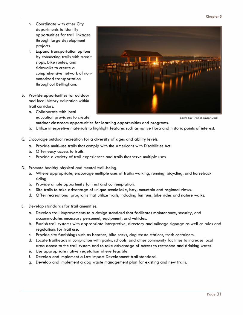
B. Provide opportunities for outdoor
and local history education within trail corridors. a. Collaborate with local
education providers to create outdoor classroom opportunities for learning opportunities and programs.
b. Utilize interpretive materials to highlight features such as native flora and historic points of interest. C. Encourage outdoor recreation for a diversity of ages and ability levels.
a. Provide multi-use trails that comply with the Americans with Disabilities Act. b. Offer easy access to trails. c. Provide a variety of trail experiences and trails that serve multiple uses.
D. Promote healthy physical and mental well-being.
a. Where appropriate, encourage multiple uses of trails: walking, running, bicycling, and horseback riding.
b. Provide ample opportunity for rest and contemplation. c. Site trails to take advantage of unique scenic lake, bay, mountain and regional views. d. Offer recreational programs that utilize trails, including fun runs, bike rides and nature walks.
E. Develop standards for trail amenities.
a. Develop trail improvements to a design standard that facilitates maintenance, security, and accommodates necessary personnel, equipment, and vehicles.
b. Furnish trail systems with appropriate interpretive, directory and mileage signage as well as rules and regulations for trail use.
c. Provide site furnishings such as benches, bike racks, dog waste stations, trash containers. d. Locate trailheads in conjunction with parks, schools, and other community facilities to increase local
area access to the trail system and to take advantage of access to restrooms and drinking water. e. Use appropriate native vegetation where feasible. f. Develop and implement a Low Impact Development trail standard. g. Develop and implement a dog waste management plan for existing and new trails.
South Bay Trail at Taylor Dock
Page 31

Chapter 5
F. Advance City-wide priorities to protect, rehabilitate and maintain functioning habitats and corridors in collaboration with other City departments. a. Develop trails and greenway corridors that protect, rehabilitate and maintain natural resources,
including plant and animal habitats. b. Complete trail connections, in a manner that is appropriate, along greenways corridors like Squalicum,
Whatcom, and Padden Creeks to provide a high quality, diverse sampling of area environmental resources.
G. Provide a safe trail environment.
a. Utilize Crime Prevention through Environmental Design concepts. b. Provide lighting in high-use areas and where appropriate. c. Provide safe parking areas. d. Avoid blind corners on trails. e. Where appropriate, provide for surveillance of trails from adjacent property. f. Provide safety education for trail users. g. Provide safe crossings of roads, including grade separated crossings of major corridors such as I-5
and Guide Meridian Street. h. Clearly mark dog off leash areas along trails and enforce on leash rules where they apply.
H. Encourage community involvement and stewardship of trails. a. Continue and expand the Parks Volunteer Program. b. Continue and expand the Adopt-a-Trail program. c. Develop inter-local trail management agreements. d. Encourage participation in community trail events. e. Expand on existing relationships with schools, business and non-profit organizations to promote and
provide trails throughout the community. 5.3 Council Legacy: Access to Quality of Life Amenities Council Strategic Commitments • Maintain & enhance publicly owned assets • Foster arts, culture & lifelong learning • Provide recreation & enrichment opportunities for all ages
& abilities • Ensure convenient access to & availability of parks & trails
City-wide Parks and Recreation Related Goals and Objectives 5.3.1 GOAL Provide high quality recreational programs and services throughout the community that provide fun, educational, accessible and safe environments for people of all ages, ethnicities, and abilities.
Summer day camp at Bloedel Donovan Park
Page 32

Chapter 5
5.3.1.1 OBJECTIVES A. Support arts and crafts, classroom instruction in music and dance, physical conditioning and health care.
B. Provide meeting facilities, preschool, after school, and other program activities for all cultural, age,
physical and mental capability, and income groups in the community.
C. Support basketball, volleyball, tennis, soccer, baseball, softball, and other team sports, including instruction and programs for all age, skill level, and income groups in the community.
D. Assist with programs and exhibits that document and develop awareness of Bellingham's heritage. 5.3.2 GOAL Design and develop facilities that are sustainable, accessible, safe, and easy to maintain, with a consideration of City-wide long-term costs and benefits. Ensure that development is compatible with habitat protection and restoration goals and polices. 5.3.2.1 OBJECTIVES A. Design outdoor picnic areas, trails, playgrounds, courts, fields, parking lots, restrooms, and other facilities
to be accessible to individuals and organized groups of all physical capabilities, skill levels, age groups, income, ethnicity and activity interests.
B. Design indoor facility spaces, activity rooms, restrooms, parking lots, and other improvements to be accessible to individuals and organized groups of all physical capabilities, skill levels, age groups, income, ethnicity and activity interests.
C. Design and develop facilities that reduce overall
facility maintenance, operation requirements and costs.
D. Where appropriate, to the greatest extent possible,
use low maintenance materials, or other value engineering considerations that reduce maintenance and security requirements, and retain natural conditions and experiences.
E. Develop a maintenance management system to
estimate and plan for life cycle maintenance and replacement costs.
F. Implement the provisions and requirements of the
Americans with Disabilities Act (ADA) and other design and development standards that improve park facility safety and security features for park users, department personnel, and the public-at-large.
G. Develop and implement safety standards, procedures, and programs that will provide proper training and awareness for department personnel.
Madrona tree at Inspiration Point
Page 33
Chapter 5
H. Define and enforce rules and regulations concerning park activities and operations that will protect user groups, department personnel, and the general public-at-large.
I. Where appropriate, use Adopt-a-Park programs, neighborhood park watches, park police patrols, and
other programs to increase safety and security awareness and visibility. J. Develop and utilize standardized identification, enforcement and wayfinding signage.
K. Work with the Whatcom County Health Department to complete an inventory of Park amenities and develop a "Parks Prescription" website for use by health care providers to direct patients to specific parks for rehabilitation and exercise.
5.4 Council Legacy: Healthy Environment Council Strategic Commitments • Protect & improve the health of lakes, streams & bay • Protect & restore ecological functions & habitat • Reduce contributions to climate change • Conserve natural & consumable resources Parks and Recreation Related Goals and Objectives 5.4.1 GOAL Contribute to a healthy environment in the selection of new properties, and the development and maintenance of park facilities. 5.4.1.1 OBJECTIVES A. Utilize efficient, ecological techniques to mitigate
stormwater at developed park and trail facilities such as infiltration and natural dispersion, where feasible.
B. Utilize Low Impact Development practices in the development and renovation of park facilities.
C. Train staff on the best management practices to be
incorporated in new development projects and in ongoing maintenance. D. Conserve natural and consumable resources by using environmentally friendly products and practices. E. Ensure that development is compatible with habitat protection and restoration goals and polices.
F. Provide recycling opportunities and facilities at public parks and points along trails.
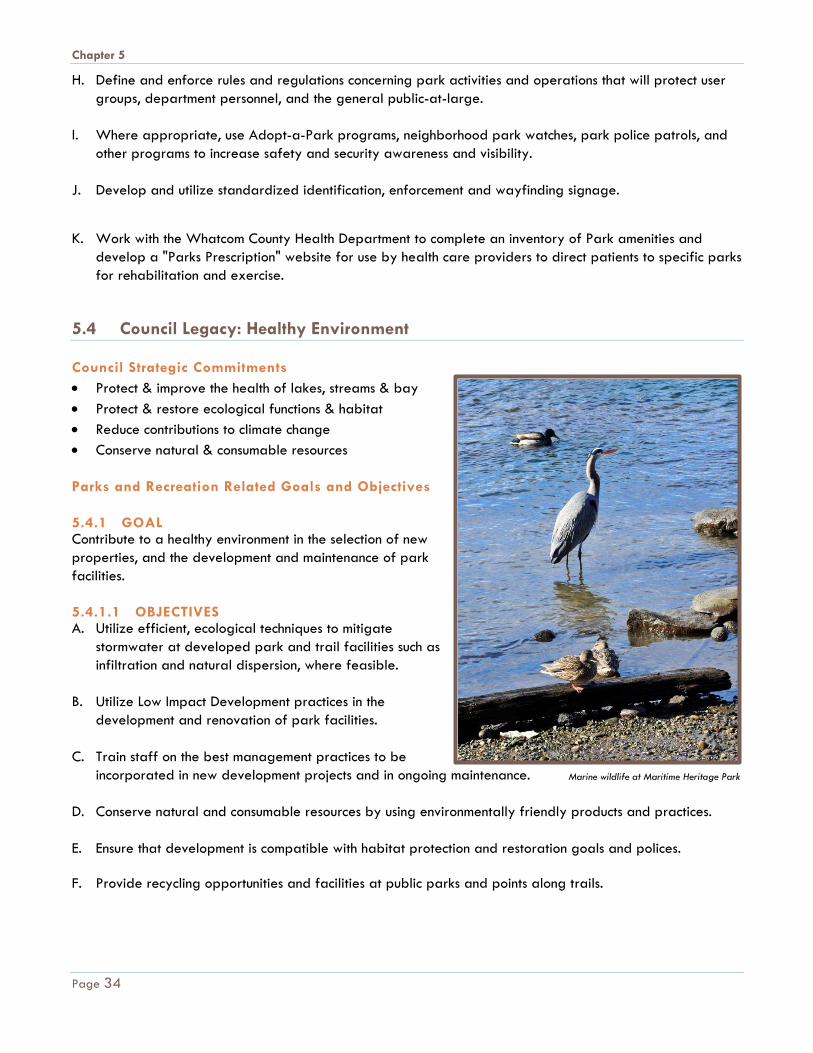
Marine wildlife at Maritime Heritage Park
Page 34

Chapter 5
5.4.2 GOAL Provide a high quality, diversified open space system that protects and enhances significant and diverse environmental resources and features, including wildlife habitat, migration corridors, agricultural lands, natural meadows, urban forests, and water resources. Work with other City departments to achieve the following objectives: 5.4.2.1 OBJECTIVES A. Define, maintain, and protect a system of open space
corridors and buffers to provide separation between natural areas and urban land uses within the Bellingham developing area.
B. Maintain, conserve and restore natural area linkages for trails.
C. Maintain land for the re-establishment, protection and enhancement of ecological functions and habitat. D. Protect significant environmental features including wetlands, woodlands, prairies, meadows, shorelines,
waterfronts, functioning urban forests, and hillsides that reflect Bellingham’s natural character. E. Balance the demand for public access and interpretive education with protection of environmentally
sensitive areas and sites that are especially unique to the Bellingham area. F. Identify and conserve wildlife habitat including nesting sites, foraging areas, and migration corridors
within or adjacent to natural areas, open spaces, and the developed urban area. G. Restore, protect and improve habitat sites, including creeks and streams that support threatened species
and urban wildlife. H. Maintain and restore unique environmental features or areas in future land developments and increase
public use and access. Cooperate with other public and private agencies and with private landowners to set aside unique features or areas as publicly accessible resources.
I. Provide operation and maintenance resources for forestry management, habitat protection and code
enforcement in existing and new open space areas. J. When necessary for mitigation, develop, maintain and monitor wetland enhancement sites for successful
establishment. K. Involve the community in on-going habitat restoration and maintenance activities through the Parks
Volunteer Program. L. Limit access by people and pets at high priority habitat protection, restoration and enhancement sites. M. Cooperate with ongoing City-wide habitat restoration efforts.
Deer at Woodstock Farm
Page 35

Chapter 5
5.5 Council Legacy: Vibrant Sustainable Economy Council Strategic Commitments • Support a thriving local economy across all
sectors • Promote inter-dependence of
environmental, economic & social interests • Create conditions that encourage public &
private investment • Foster vibrant downtown & other
commercial centers • Preserve farmland & the agricultural
economy Parks and Recreation Related Goals and Objectives 5.5.1 GOAL Meet the needs of the present without compromising the needs of future generations. Make decisions today that sustain our activities and the natural environment for the future. 5.5.1.1 OBJECTIVES A. Promote sustainable landscapes to protect, maintain and restore ecological functions of natural areas.
Protect park and open space lands by reducing adverse impacts to the environment during development and long term use.
B. Reduce emissions, pollution, and toxic materials to protect water and other natural resources. Mitigate the
use of fossil fuels by reducing energy and vehicle use. Promote multi-modal transportation by developing trails and locating parks on bus routes or within walking distance of residents.
C. Foster environmental stewardship through education programs and activities. D. Provide safe and convenient access to public lands, conservation areas, and water that does not damage
critical areas. E. Instill a love of nature and a commitment for caring for our resources through the Park Volunteer program. F. Choose durable products to promote human health in a safe environment and consider life-cycle analysis
of material options. Incorporate green building technology including nontoxic materials and sustainable development practices. Select local products where feasible. Consider environmental as well as economic impacts.
G. Provide scholarships for low income families to participate in recreation activities. H. Maintain a world class park system that attracts tourism and benefits the local economy.
"Dirty Dan Harris" at Fairhaven Village Green. Photo by Kenni Merritt.
Page 36
Chapter 5
I. Foster volunteer groups that support special use facilities such as the Woodstock Farm Conservancy and Friends of Big Rock Garden.
J. Provide spaces for community events equitably throughout the City such the Farmer’s Market and the
outdoor cinema at Fairhaven Village Green. 5.6 Council Legacy: Quality, Responsive City Services Council Strategic Commitments • Deliver efficient, effective & accountable municipal services • Use transparent processes & involve stakeholders in
decisions • Provide access to accurate information • Recruit, retain & support quality employees Parks and Recreation Related Goals and Objectives 5.6.1 GOAL Create effective and efficient methods of acquiring, developing, operating and maintaining facilities and programs that accurately distribute costs and benefits to public and private interests. 5.6.1.1 OBJECTIVES A. Investigate innovative means to finance maintenance and
operating needs in order to reduce costs, retain financial flexibility, match user benefits and interests, and increase facility services.
B. Consider joint ventures with other public and private agencies such as the Bellingham School District,
Whatcom County, Port of Bellingham, Whatcom Community College, regional, state, federal, and other public and private agencies including for-profit concessionaires, where feasible and desirable.
C. To best serve and provide for area residents' interests, create a comprehensive and balanced park,
recreation, and open space system that integrates Bellingham facilities and services with resources available from the Bellingham School District, Whatcom County, Port of Bellingham, Whatcom Community College and other state, federal, and private park and recreational lands and facilities.
D. Coordinate with the Bellingham School District, Whatcom County, Port of Bellingham, Whatcom Community
College and other public and private agencies to avoid duplication, improve facility quality and availability, and reduce costs through joint planning and development efforts.
E. Create effective and efficient methods of acquiring, developing, operating, and maintaining park and
recreational facilities that accurately distributes costs and benefits to public and private user interests - including the application of impact fees where new developments impact level-of-service standards.
F. Develop and operate lifetime recreational programs that serve the broadest needs of the population, while recovering program and operating costs with a combination of registration fees, user fees, grants, sponsorships, donations, scholarships, volunteer efforts, and the use of general funding.
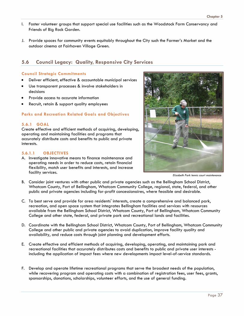
Elizabeth Park tennis court maintenance
Page 37

Chapter 5
G. Where appropriate, provide recreational programs, like golf and boating facilities, for user groups willing to finance the cost through donations, registration fees, volunteer efforts or other means and methods.
H. Investigate and pursue innovative means of incorporating social media and other technologies to efficiently provide information to and engage the public.
5.6.2 GOAL Develop, staff, train, and support a professional Parks and Recreation Department that effectively serves the community. 5.6.2.1 OBJECTIVES A. Employ a diverse, well-trained work force that is knowledgeable, productive, courteous, responsive and
motivated to achieve department and City-wide goals.
B. Encourage teamwork through communication-, creativity, positive image, risk taking, sharing of resources, and cooperation toward common goals.
C. Provide staff with education, training, equipment and supplies to increase personal productivity,
efficiency, and pride. D. Monitor work load and staffing needs to maintain an adequate, efficient work force.
E. Provide sensitivity training for proper awareness of protected classes. 5.7 Council Legacy: Clean, Safe Drinking Water Council Strategic Commitments
• Protect & improve drinking water sources • Limit development in Lake Whatcom
watershed • Use efficient, ecological treatment
techniques • Maintain reliable distribution system • Promote water conservation
Parks and Recreation Related Goals and Objectives 5.7.1 GOAL Protect our drinking water source by appropriately protecting, restoring and managing park lands in the Lake Whatcom Watershed. 5.7.1.1 OBJECTIVES A. Mitigate public demand for recreation in the watershed with appropriate protection measures through
design and maintenance. Limit access where impacts to water quality may occur.
B. Manage dog off-leash areas to reduce impacts.
Bloedel Donovan Park on Lake Whatcom.
Page 38

Chapter 5
C. Implement on-site stormwater infiltration to reduce runoff. D. Maintain and enhance the forested condition of park properties in the watershed.
E. Work with private organizations to promote non-motorized boating on Lake Whatcom.
F. Cooperate with boater education, safety and inspection programs. 5.7.2 GOAL Promote water conservation at all park facilities. 5.7.2.1 OBJECTIVES A. Utilize drought tolerant plants where appropriate.
B. Reduce irrigation of established lawns. C. Incorporate programmable irrigation systems which are operated by a central computer system at ball
fields and at Lake Padden Golf Course. D. Provide non-irrigated landscape demonstration sites. 5.8 Council Legacy: Safe and Prepared Community Council Strategic Commitments
• Prevent and respond to emergencies • Prevent and respond to crime • Ensure safe infrastructure • Increase community readiness and
resilience Parks and Recreation Related Goals and Objectives 5.8.1 GOAL Contribute to making Bellingham a safe and prepared community. 5.8.1.1 OBJECTIVES A. Assess and manage risks associated with
trees and vegetation on City property.
B. Incorporate crime prevention through environmental design and maintenance. C. Consider emergency access in trail and open space design and maintenance.
D. Promote safe and fun recreational opportunities that are deterrence to crime.
E. Provide lifeguard and water safety programs at Arne Hanna Aquatic Center. F. Provide First Aid/CPR/AED certification classes and training through Arne Hanna Aquatic Center. G. Cooperate with agencies in providing park property for emergency response training.
Park Arborist
Page 39
Chapter 5
H. Hire and retain professionally certified, trained staff to design, inspect and maintain park infrastructure. 5.9 Council Legacy: Equity and Social Justice Council Strategic Commitments
• Provide access to problem-solving resources • Support safe, affordable housing • Increase living wage employment • Support services for lower-income
residents • Cultivate respect & appreciation for
diversity Parks and Recreation Related Goals and Objectives 5.9.1 GOAL Provide equitable access to park and recreation facilities and services to all residents of our community. 5.9.1.1 OBJECTIVES A. Provide parks that create places for people
to elevate their mental, physical and spiritual health.
B. Provide a variety of programs that foster social problem-solving, teamwork, cooperation, volunteerism, respect and stewardship.
C. Support social service providers with outlets to distribute information to the community. D. Utilize Community Development Block Grant funds and other resources to provide parks in low income
neighborhoods. E. Provide scholarships for low income families and individuals. F. Offer and support integrated recreation programs for people of all abilities and resources.
G. Provide public gathering areas where people can assemble for social interaction and to exercise
freedom of speech.
H. Provide culturally appropriate programming and services.
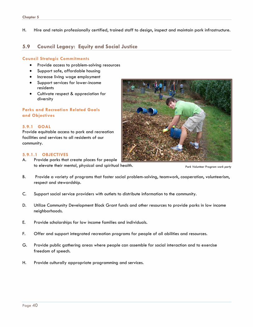
Park Volunteer Program work party
Page 40
Chapter 6
Chapter 6 R E C O M M E N D A T I O N S
The following recommendations for park, recreation and open space facilities in Bellingham are based on the results of existing inventories, needs analysis (trends, population, level-of-service), public input, workshop, and surveys. The recommendations outline the vision developed for the park system within the Bellingham urban growth area through the year 2036, although the PRO Plan is scheduled to be updated again in 2020 for state funding purposes. A detailed list of each proposed facility is included in Appendix C of the PRO Plan. The recommendations, proposals and projects outlined in the PRO Plan are conceptual and subject to further study, feasibility and funding. It is specifically NOT the intention of this plan that any recommendation included here limit the City’s ability to act on an opportunity that may arise provided the opportunity supports the overall vision, goals or objectives of the Parks and Recreation Department in Bellingham as discussed in the PRO Plan.
Coordination with other public or private entities that may be affected by or interested in the final outcome of any particular project, such as adjacent residents or funding partners, may influence the final outcome of a particular recommendation. As a result, all recommendations presented here are done with the understanding that they will only be implemented as opportunity, funding, and feasibility allow. All land acquisitions and capital projects are subject to further approval by the City Council.
Overall Vision
• More Trail and Trail
Connections
• Equal Access to Park
Facilities and Programs
• Water Access
• Environment
• Variety
Page 41
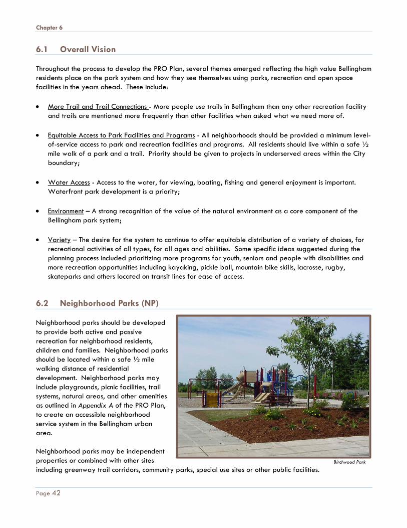
Chapter 6
6.1 Overall Vision Throughout the process to develop the PRO Plan, several themes emerged reflecting the high value Bellingham residents place on the park system and how they see themselves using parks, recreation and open space facilities in the years ahead. These include: • More Trail and Trail Connections - More people use trails in Bellingham than any other recreation facility
and trails are mentioned more frequently than other facilities when asked what we need more of. • Equitable Access to Park Facilities and Programs - All neighborhoods should be provided a minimum level-
of-service access to park and recreation facilities and programs. All residents should live within a safe ½ mile walk of a park and a trail. Priority should be given to projects in underserved areas within the City boundary;
• Water Access - Access to the water, for viewing, boating, fishing and general enjoyment is important.
Waterfront park development is a priority; • Environment – A strong recognition of the value of the natural environment as a core component of the
Bellingham park system; • Variety – The desire for the system to continue to offer equitable distribution of a variety of choices, for
recreational activities of all types, for all ages and abilities. Some specific ideas suggested during the planning process included prioritizing more programs for youth, seniors and people with disabilities and more recreation opportunities including kayaking, pickle ball, mountain bike skills, lacrosse, rugby, skateparks and others located on transit lines for ease of access.
6.2 Neighborhood Parks (NP) Neighborhood parks should be developed to provide both active and passive recreation for neighborhood residents, children and families. Neighborhood parks should be located within a safe ½ mile walking distance of residential development. Neighborhood parks may include playgrounds, picnic facilities, trail systems, natural areas, and other amenities as outlined in Appendix A of the PRO Plan, to create an accessible neighborhood service system in the Bellingham urban area. Neighborhood parks may be independent properties or combined with other sites including greenway trail corridors, community parks, special use sites or other public facilities.
Birchwood Park
Page 42
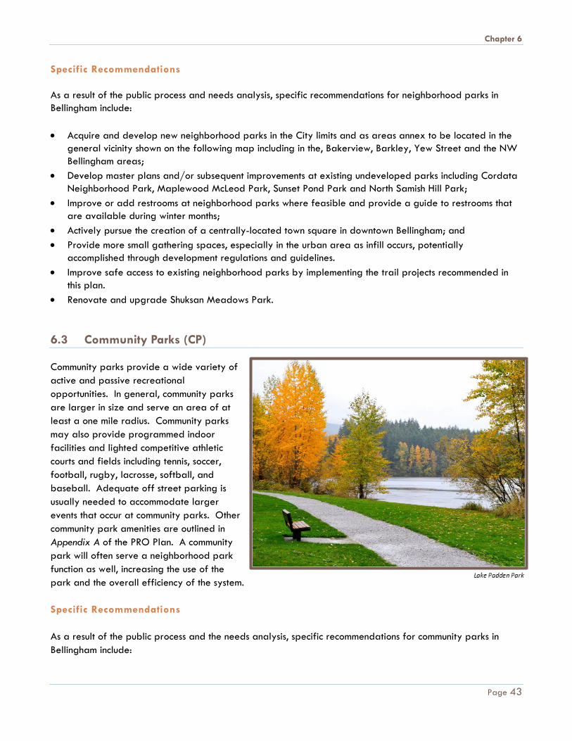
Chapter 6
Specific Recommendations As a result of the public process and needs analysis, specific recommendations for neighborhood parks in Bellingham include: • Acquire and develop new neighborhood parks in the City limits and as areas annex to be located in the
general vicinity shown on the following map including in the, Bakerview, Barkley, Yew Street and the NW Bellingham areas;
• Develop master plans and/or subsequent improvements at existing undeveloped parks including Cordata Neighborhood Park, Maplewood McLeod Park, Sunset Pond Park and North Samish Hill Park;
• Improve or add restrooms at neighborhood parks where feasible and provide a guide to restrooms that are available during winter months;
• Actively pursue the creation of a centrally-located town square in downtown Bellingham; and • Provide more small gathering spaces, especially in the urban area as infill occurs, potentially
accomplished through development regulations and guidelines. • Improve safe access to existing neighborhood parks by implementing the trail projects recommended in
this plan. • Renovate and upgrade Shuksan Meadows Park. 6.3 Community Parks (CP) Community parks provide a wide variety of active and passive recreational opportunities. In general, community parks are larger in size and serve an area of at least a one mile radius. Community parks may also provide programmed indoor facilities and lighted competitive athletic courts and fields including tennis, soccer, football, rugby, lacrosse, softball, and baseball. Adequate off street parking is usually needed to accommodate larger events that occur at community parks. Other community park amenities are outlined in Appendix A of the PRO Plan. A community park will often serve a neighborhood park function as well, increasing the use of the park and the overall efficiency of the system. Specific Recommendations As a result of the public process and the needs analysis, specific recommendations for community parks in Bellingham include:
Page 43
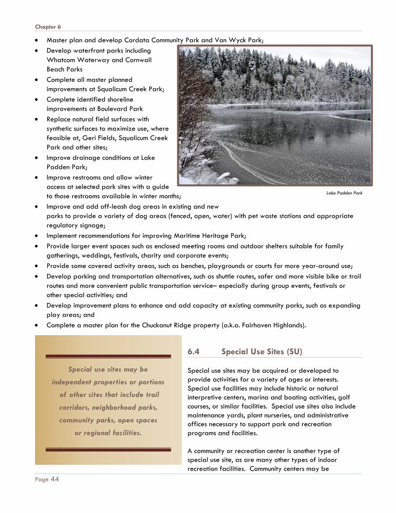
Chapter 6
• Master plan and develop Cordata Community Park and Van Wyck Park; • Develop waterfront parks including
Whatcom Waterway and Cornwall Beach Parks
• Complete all master planned improvements at Squalicum Creek Park;
• Complete identified shoreline improvements at Boulevard Park
• Replace natural field surfaces with synthetic surfaces to maximize use, where feasible at, Geri Fields, Squalicum Creek Park and other sites;
• Improve drainage conditions at Lake Padden Park;
• Improve restrooms and allow winter access at selected park sites with a guide to those restrooms available in winter months;
• Improve and add off-leash dog areas in existing and new parks to provide a variety of dog areas (fenced, open, water) with pet waste stations and appropriate regulatory signage;
• Implement recommendations for improving Maritime Heritage Park; • Provide larger event spaces such as enclosed meeting rooms and outdoor shelters suitable for family
gatherings, weddings, festivals, charity and corporate events; • Provide some covered activity areas, such as benches, playgrounds or courts for more year-around use; • Develop parking and transportation alternatives, such as shuttle routes, safer and more visible bike or trail
routes and more convenient public transportation service– especially during group events, festivals or other special activities; and
• Develop improvement plans to enhance and add capacity at existing community parks, such as expanding play areas; and
• Complete a master plan for the Chuckanut Ridge property (a.k.a. Fairhaven Highlands). 6.4 Special Use Sites (SU) Special use sites may be acquired or developed to provide activities for a variety of ages or interests. Special use facilities may include historic or natural interpretive centers, marina and boating activities, golf courses, or similar facilities. Special use sites also include maintenance yards, plant nurseries, and administrative offices necessary to support park and recreation programs and facilities. A community or recreation center is another type of special use site, as are many other types of indoor recreation facilities. Community centers may be
Special use sites may be
independent properties or portions
of other sites that include trail
corridors, neighborhood parks,
community parks, open spaces
or regional facilities.
Lake Padden Park
Page 44

Chapter 6
developed to provide indoor activities for day and evening use on a year-around basis. They may utilize the existing municipal, county, and school facilities by providing space for gymnasiums, physical conditioning, arts and crafts, class and instruction rooms, meeting facilities, teen and senior centers and other resource activities for special populations. Community centers may also incorporate visual or performing arts, historic and interpretive exhibits, and other specialized activities and be developed as stand-alone facilities or jointly with administrative or maintenance activities. Specific Recommendations As a result of the public process and the needs analysis, specific recommendations for special use sites in the Bellingham park system include:
• Implement improvements at Woodstock Farm to include parking and a trail access plan and other improvements as feasible. Develop a long range maintenance plan for the site;
• Implement improvements at Big Rock Garden;
• Provide environmental education opportunities such as interpretive signage and/or other educational and stewardship related activities or programs to promote the value of the natural environment throughout the park system;
• Acquire or develop new or improved town square or plaza space downtown and in urban villages such as Old Town, Samish and at Fountain Plaza;
• Acquire and develop new hand-carry boat launch or landing facilities in conjunction with park development in the Waterfront District and at other locations shown on the map on page 48; and
• Acquire and renovate the pier for public access at Little Squalicum Park. • Access appropriate location for a north end skate park.
Woodstock Farm
Page 45
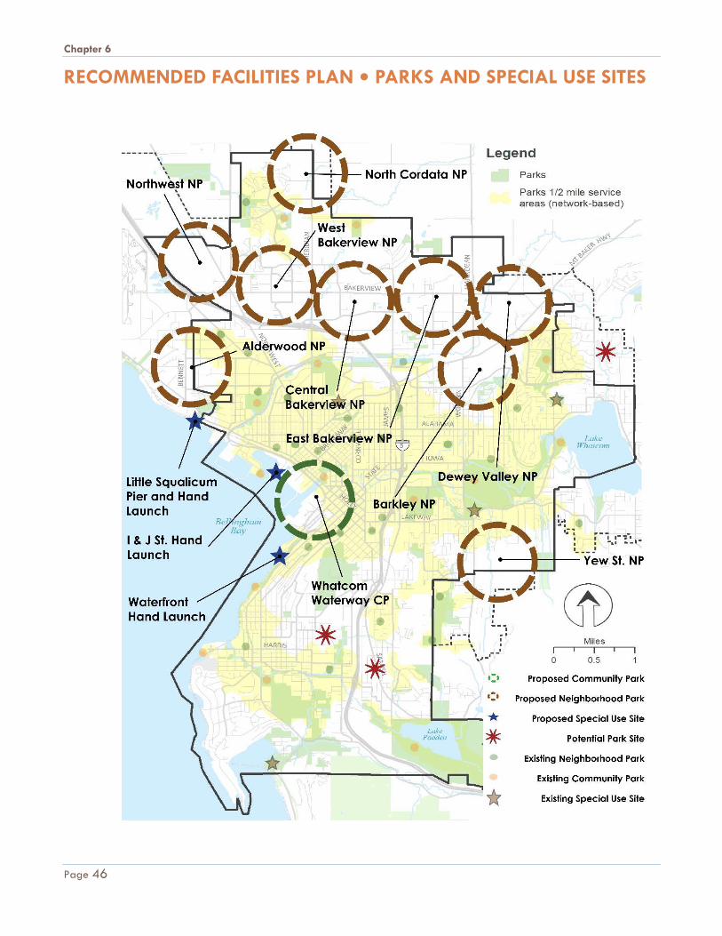
Chapter 6
RECOMMENDED FACILITIES PLAN • PARKS AND SPECIAL USE SITES
Page 46
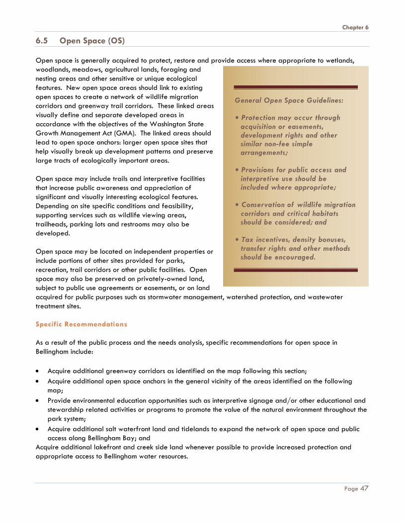
Chapter 6
6.5 Open Space (OS) Open space is generally acquired to protect, restore and provide access where appropriate to wetlands, woodlands, meadows, agricultural lands, foraging and nesting areas and other sensitive or unique ecological features. New open space areas should link to existing open spaces to create a network of wildlife migration corridors and greenway trail corridors. These linked areas visually define and separate developed areas in accordance with the objectives of the Washington State Growth Management Act (GMA). The linked areas should lead to open space anchors: larger open space sites that help visually break up development patterns and preserve large tracts of ecologically important areas. Open space may include trails and interpretive facilities that increase public awareness and appreciation of significant and visually interesting ecological features. Depending on site specific conditions and feasibility, supporting services such as wildlife viewing areas, trailheads, parking lots and restrooms may also be developed. Open space may be located on independent properties or include portions of other sites provided for parks, recreation, trail corridors or other public facilities. Open space may also be preserved on privately-owned land, subject to public use agreements or easements, or on land acquired for public purposes such as stormwater management, watershed protection, and wastewater treatment sites. Specific Recommendations As a result of the public process and the needs analysis, specific recommendations for open space in Bellingham include: • Acquire additional greenway corridors as identified on the map following this section; • Acquire additional open space anchors in the general vicinity of the areas identified on the following
map; • Provide environmental education opportunities such as interpretive signage and/or other educational and
stewardship related activities or programs to promote the value of the natural environment throughout the park system;
• Acquire additional salt waterfront land and tidelands to expand the network of open space and public access along Bellingham Bay; and
Acquire additional lakefront and creek side land whenever possible to provide increased protection and appropriate access to Bellingham water resources.
General Open Space Guidelines:
• Protection may occur through acquisition or easements, development rights and other similar non-fee simple arrangements;
• Provisions for public access and interpretive use should be included where appropriate;
• Conservation of wildlife migration corridors and critical habitats should be considered; and
• Tax incentives, density bonuses, transfer rights and other methods should be encouraged.
Page 47
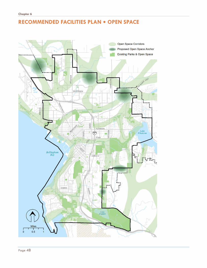
Chapter 6
RECOMMENDED FACILITIES PLAN • OPEN SPACE
Page 48
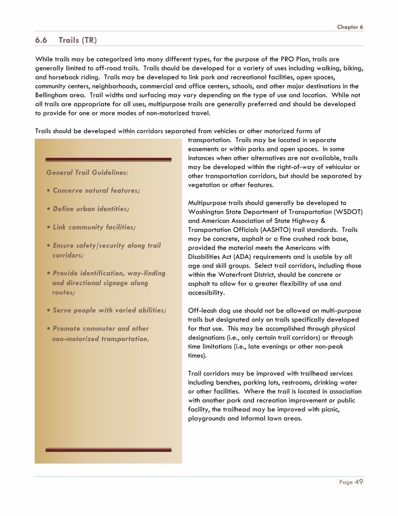
Chapter 6
6.6 Trails (TR) While trails may be categorized into many different types, for the purpose of the PRO Plan, trails are generally limited to off-road trails. Trails should be developed for a variety of uses including walking, biking, and horseback riding. Trails may be developed to link park and recreational facilities, open spaces, community centers, neighborhoods, commercial and office centers, schools, and other major destinations in the Bellingham area. Trail widths and surfacing may vary depending on the type of use and location. While not all trails are appropriate for all uses, multipurpose trails are generally preferred and should be developed to provide for one or more modes of non-motorized travel. Trails should be developed within corridors separated from vehicles or other motorized forms of
transportation. Trails may be located in separate easements or within parks and open spaces. In some instances when other alternatives are not available, trails may be developed within the right-of-way of vehicular or other transportation corridors, but should be separated by vegetation or other features. Multipurpose trails should generally be developed to Washington State Department of Transportation (WSDOT) and American Association of State Highway & Transportation Officials (AASHTO) trail standards. Trails may be concrete, asphalt or a fine crushed rock base, provided the material meets the Americans with Disabilities Act (ADA) requirements and is usable by all age and skill groups. Select trail corridors, including those within the Waterfront District, should be concrete or asphalt to allow for a greater flexibility of use and accessibility. Off-leash dog use should not be allowed on multi-purpose trails but designated only on trails specifically developed for that use. This may be accomplished through physical designations (i.e., only certain trail corridors) or through time limitations (i.e., late evenings or other non-peak times). Trail corridors may be improved with trailhead services including benches, parking lots, restrooms, drinking water or other facilities. Where the trail is located in association with another park and recreation improvement or public facility, the trailhead may be improved with picnic, playgrounds and informal lawn areas.
General Trail Guidelines:
• Conserve natural features;
• Define urban identities;
• Link community facilities;
• Ensure safety/security along trail corridors;
• Provide identification, way-finding and directional signage along routes;
• Serve people with varied abilities;
• Promote commuter and other non-motorized transportation.
Page 49

Chapter 6
Shoreline trails may be unimproved and may cross over tidelands. Trails may also include boardwalks developed over wetlands, other water bodies or on top of jetty breakwaters to provide access to waterfront activities and viewpoints along lakes, natural areas, or Bellingham and Chuckanut Bays. Multipurpose trail corridors may be independent properties or include portions of other sites provided for parks, open space or other public facilities. Linked with open space areas and greenways, multipurpose trails create a system of corridors to integrate and define the developed portions of the urban area from each other in accordance with the Growth Management Act's (GMA) provisions for urban separators. Specific Recommendations As a result of the public process and the needs analysis, specific recommendations for multi-purpose trails in Bellingham include: • Acquire and/or develop new trail connections as shown on the following map in order to provide an off-
street trail within a half mile of every resident in Bellingham; • Coordinate with Public Works to identify opportunities for better trail, sidewalk and bike route
connectivity; • Continue to explore new trail surface alternatives that balance the natural character of Bellingham's trail
system with accessibility requirements, long-term maintenance, sustainable development practices and availability of local materials;
• Institute a maintenance replacement program to monitor, maintain, improve and/or replace trail features, including bridges, boardwalks and stairs;
• Acquire and/or develop trailheads (parking, signage, restrooms, picnic areas, etc.) at Whatcom Falls Park, Galbraith Mountain area, Woodstock Farm, Fairhaven Park Forest and North Chuckanut Trailhead;
• Acquire and develop safe multimodal crossings of Guide Meridian Street and Interstate 5 in key locations both generally located on the following map or as new opportunities and needs arise.
• Coordinate with the Port of Bellingham to identify a trail corridor around the airport. • As areas annex or rezone, consider the need and opportunity for trail connectivity.
Northridge Park Trail
Northridge Park trail
Page 50

Chapter 6
RECOMMENDED FACILITIES PLAN • TRAILS
Page 51

Chapter 7
Chapter 7 I M P L E M E N T A T I O N
The financial strategy for Bellingham Parks and Recreation for the next six to 20-year period should generate sufficient revenue to maintain existing facilities, provide recreational program services, renovate facilities, and implement priority projects from the proposed recommendations. The following forecasts are based on average trends in capital facility fund expenditures by the City during recent years. However, it should be noted that priorities shift over time, responding to new interests, opportunities, and community decision making processes. The City’s six-year Capital Facilities Plan (CFP) is updated at least bi-annually in part to reflect these changes. Recommendations outlined in Chapter 6 of the PRO Plan total approximately $104 million in today's dollars. This includes improvements to existing facilities, as well as additional land and facilities to serve new growth. Projected revenue sources for park system improvements through the year 2036 could provide enough funding for the priority projects with traditional funding sources as estimated with the assumptions shown in the following table. Detailed costs for proposed recommendations are included in Appendix C of the PRO Plan. The 2015 and 2016 approved six-year Capital Facilities Plans are included in Appendix E of the PRO Plan. 7.1 Revenue and Expenditures Table 7.1 outlines options for capital revenue sources and projected expenditures through the year 2036, and corresponds with the adopted level-of-service discussed in Chapter 4 and the recommendations included in Chapter 6 of the PRO Plan. A detailed description of the projects and costs is in Appendix C of the PRO Plan. A description of the funding sources and assumptions made for each item in the tables is listed on the following pages.
Priorities and proposed
recommendations
implemented may change
over time based on new
interests, feasibility and/or
opportunities that may
arise.
Whatcom Falls Park
Page 52
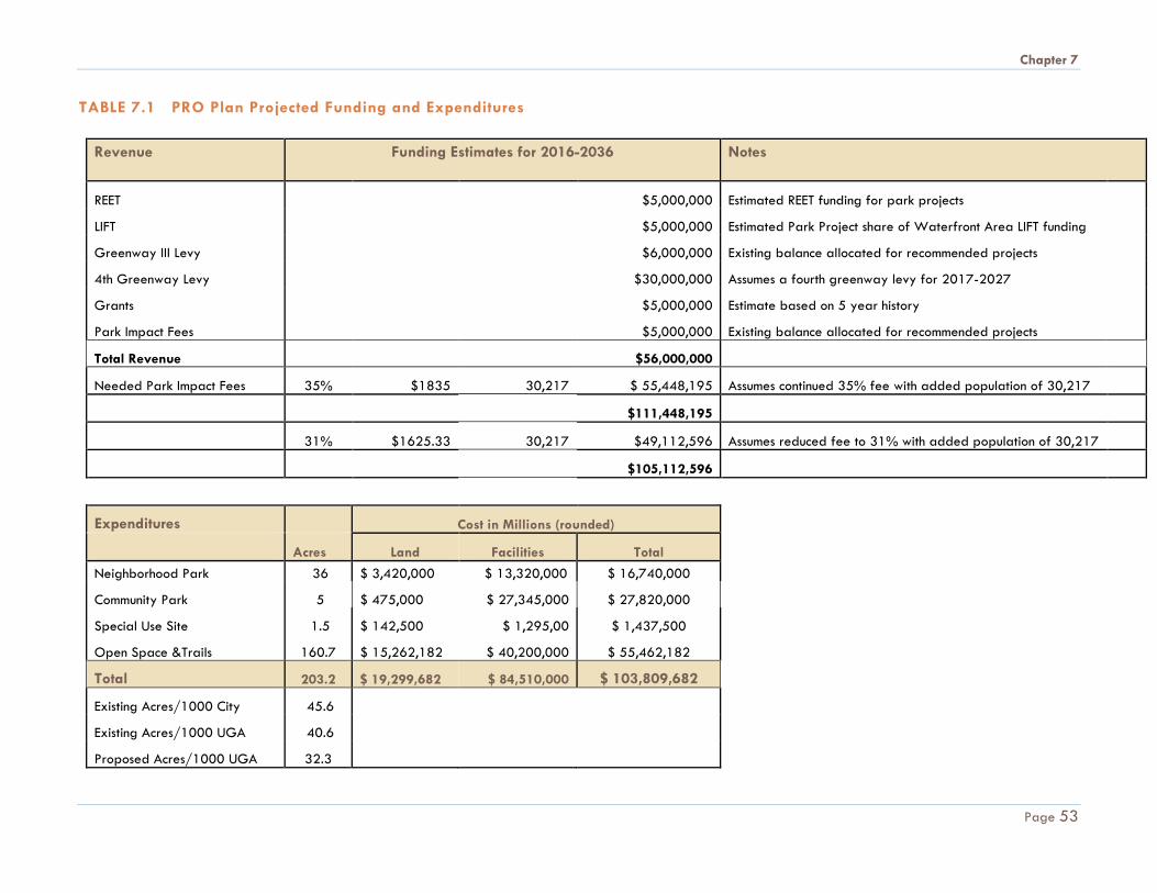
Chapter 7
TABLE 7.1 PRO Plan Projected Funding and Expenditures
Revenue Funding Estimates for 2016-2036 Notes
REET $5,000,000 Estimated REET funding for park projects
LIFT $5,000,000 Estimated Park Project share of Waterfront Area LIFT funding
Greenway III Levy $6,000,000 Existing balance allocated for recommended projects
4th Greenway Levy $30,000,000 Assumes a fourth greenway levy for 2017-2027
Grants $5,000,000 Estimate based on 5 year history
Park Impact Fees $5,000,000 Existing balance allocated for recommended projects
Total Revenue $56,000,000
Needed Park Impact Fees 35% $1835 30,217 $ 55,448,195 Assumes continued 35% fee with added population of 30,217
$111,448,195
31% $1625.33 30,217 $49,112,596 Assumes reduced fee to 31% with added population of 30,217
$105,112,596
Expenditures Cost in Millions (rounded)
Acres Land Facilities Total Neighborhood Park 36 $ 3,420,000 $ 13,320,000 $ 16,740,000
Community Park 5 $ 475,000 $ 27,345,000 $ 27,820,000
Special Use Site 1.5 $ 142,500 $ 1,295,00 $ 1,437,500
Open Space &Trails 160.7 $ 15,262,182 $ 40,200,000 $ 55,462,182
Total 203.2 $ 19,299,682 $ 84,510,000 $ 103,809,682
Existing Acres/1000 City 45.6
Existing Acres/1000 UGA 40.6
Proposed Acres/1000 UGA 32.3
Page 53
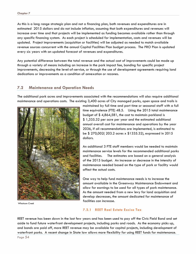
Chapter 7
As this is a long range strategic plan and not a financing plan, both revenues and expenditures are in estimated 2015 dollars and do not include inflation, assuming that both expenditures and revenues will increase over time and that projects will be implemented as funding becomes available rather than through any specific financing system. As each project is scheduled for implementation, costs and revenues will be updated. Project improvements (acquisition or facilities) will be adjusted as needed to match available revenue sources concurrent with the annual Capital Facilities Plan budget process. The PRO Plan is updated every six years with an updated forecast of revenues and expenditures.
Any potential difference between the total revenue and the actual cost of improvements could be made up through a variety of means including an increase in the park impact fee, bonding for specific project improvements, decreasing the level-of-service, or through the use of development agreements requiring land dedications or improvements as a condition of annexation or rezones. 7.2 Maintenance and Operation Needs The additional park acres and improvements associated with the recommendations will also require additional maintenance and operations costs. The existing 3,400 acres of City managed parks, open space and trails is
maintained by full time and part time or seasonal staff with a full time equivalence (FTE) 48.5. Using the 2015 total maintenance budget of $ 4,864,581, the cost to maintain parkland is $ 1,335.32 per acre per year and the estimated additional annual overall cost for maintenance and operations by the year 2036, if all recommendations are implemented, is estimated to be $ 270,002( 203.2 acres x $1335.32), expressed in 2015 dollars. An additional 3 FTE staff members would be needed to maintain maintenance service levels for the recommended additional parks and facilities. The estimates are based on a general analysis of the 2015 budget. An increase or decrease in the intensity of maintenance needed based on the type of park or facility would affect the actual costs. One way to help fund maintenance needs is to increase the amount available in the Greenway Maintenance Endowment and allow for earnings to be used for all types of park maintenance. As the amount needed from a new levy for land acquisition and develop decreases, the amount dedicated for maintenance of facilities can increase. 7.2.1 REET Real Estate Excise Tax
REET revenue has been down in the last few years and has been used to pay off the Civic Field Bond and set aside to fund future waterfront development projects, including parks and roads. As the economy picks up, and bonds are paid off, more REET revenue may be available for capital projects, including development of waterfront parks. A recent change in State law allows more flexibility for using REET funds for maintenance.
Whatcom Creek
Page 54
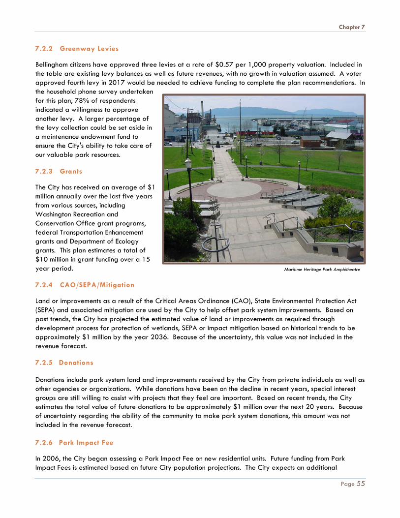
Chapter 7
7.2.2 Greenway Levies Bellingham citizens have approved three levies at a rate of $0.57 per 1,000 property valuation. Included in the table are existing levy balances as well as future revenues, with no growth in valuation assumed. A voter approved fourth levy in 2017 would be needed to achieve funding to complete the plan recommendations. In the household phone survey undertaken for this plan, 78% of respondents indicated a willingness to approve another levy. A larger percentage of the levy collection could be set aside in a maintenance endowment fund to ensure the City's ability to take care of our valuable park resources. 7.2.3 Grants The City has received an average of $1 million annually over the last five years from various sources, including Washington Recreation and Conservation Office grant programs, federal Transportation Enhancement grants and Department of Ecology grants. This plan estimates a total of $10 million in grant funding over a 15 year period. 7.2.4 CAO/SEPA/Mitigation Land or improvements as a result of the Critical Areas Ordinance (CAO), State Environmental Protection Act (SEPA) and associated mitigation are used by the City to help offset park system improvements. Based on past trends, the City has projected the estimated value of land or improvements as required through development process for protection of wetlands, SEPA or impact mitigation based on historical trends to be approximately $1 million by the year 2036. Because of the uncertainty, this value was not included in the revenue forecast. 7.2.5 Donations Donations include park system land and improvements received by the City from private individuals as well as other agencies or organizations. While donations have been on the decline in recent years, special interest groups are still willing to assist with projects that they feel are important. Based on recent trends, the City estimates the total value of future donations to be approximately $1 million over the next 20 years. Because of uncertainty regarding the ability of the community to make park system donations, this amount was not included in the revenue forecast. 7.2.6 Park Impact Fee In 2006, the City began assessing a Park Impact Fee on new residential units. Future funding from Park Impact Fees is estimated based on future City population projections. The City expects an additional
Maritime Heritage Park Amphitheatre
Page 55
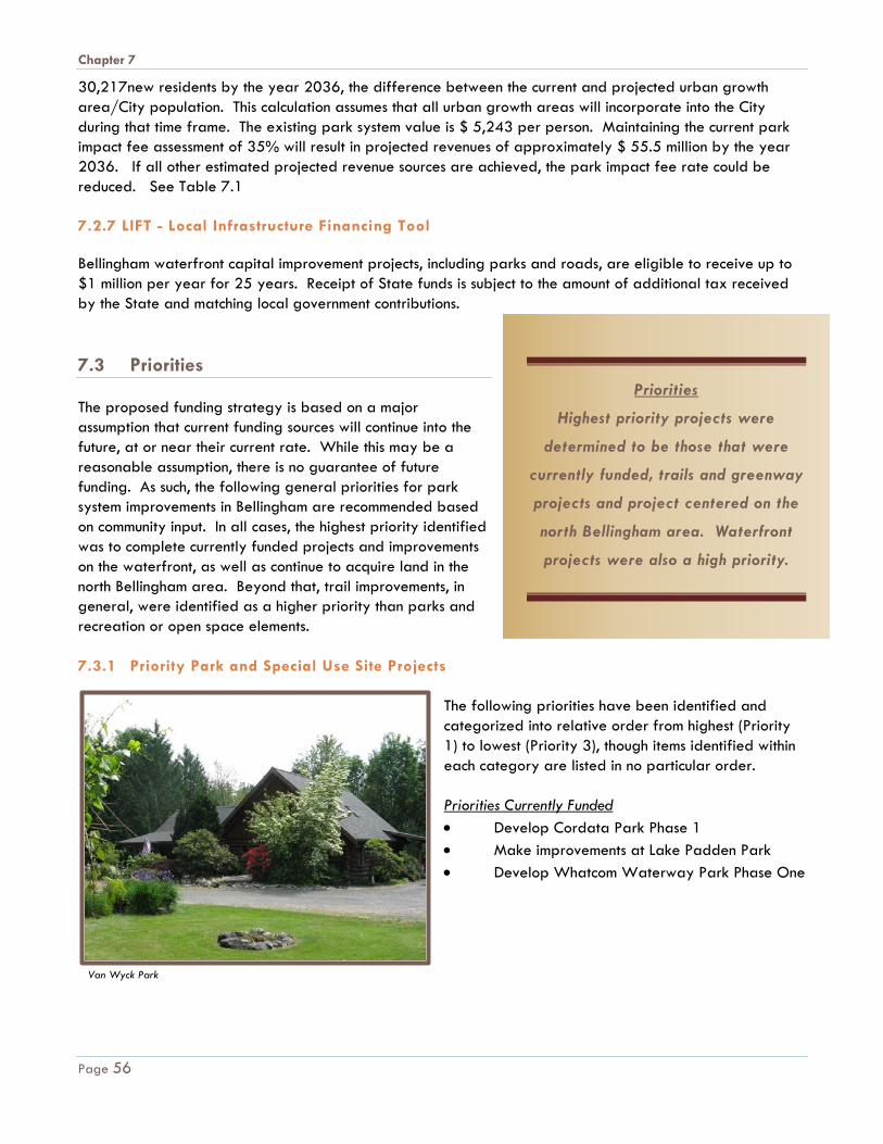
Chapter 7
30,217new residents by the year 2036, the difference between the current and projected urban growth area/City population. This calculation assumes that all urban growth areas will incorporate into the City during that time frame. The existing park system value is $ 5,243 per person. Maintaining the current park impact fee assessment of 35% will result in projected revenues of approximately $ 55.5 million by the year 2036. If all other estimated projected revenue sources are achieved, the park impact fee rate could be reduced. See Table 7.1 7.2.7 LIFT - Local Infrastructure Financing Tool Bellingham waterfront capital improvement projects, including parks and roads, are eligible to receive up to $1 million per year for 25 years. Receipt of State funds is subject to the amount of additional tax received by the State and matching local government contributions. 7.3 Priorities The proposed funding strategy is based on a major assumption that current funding sources will continue into the future, at or near their current rate. While this may be a reasonable assumption, there is no guarantee of future funding. As such, the following general priorities for park system improvements in Bellingham are recommended based on community input. In all cases, the highest priority identified was to complete currently funded projects and improvements on the waterfront, as well as continue to acquire land in the north Bellingham area. Beyond that, trail improvements, in general, were identified as a higher priority than parks and recreation or open space elements. 7.3.1 Priority Park and Special Use Site Projects
The following priorities have been identified and categorized into relative order from highest (Priority 1) to lowest (Priority 3), though items identified within each category are listed in no particular order. Priorities Currently Funded • Develop Cordata Park Phase 1 • Make improvements at Lake Padden Park • Develop Whatcom Waterway Park Phase One
Van Wyck Park
Priorities
Highest priority projects were
determined to be those that were
currently funded, trails and greenway
projects and project centered on the
north Bellingham area. Waterfront
projects were also a high priority.
Page 56
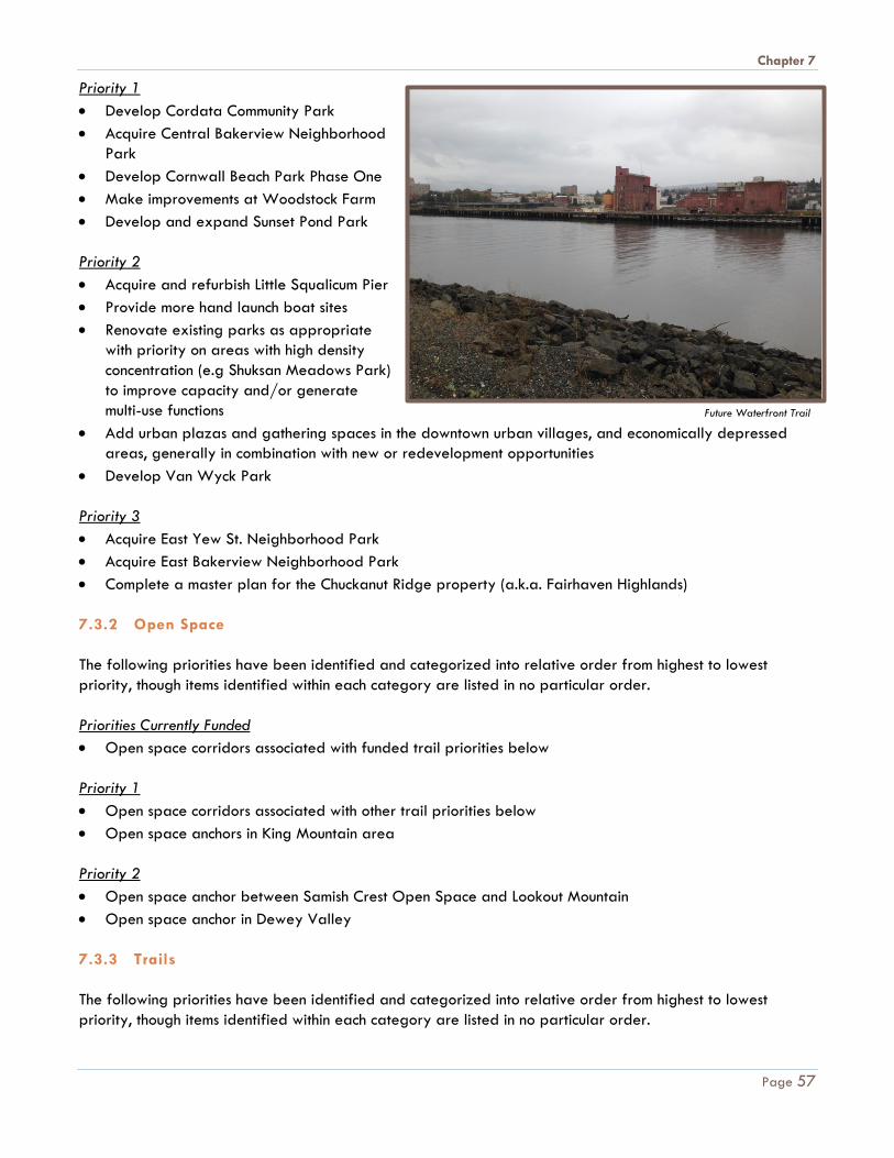
Chapter 7
Priority 1 • Develop Cordata Community Park • Acquire Central Bakerview Neighborhood
Park • Develop Cornwall Beach Park Phase One • Make improvements at Woodstock Farm • Develop and expand Sunset Pond Park Priority 2 • Acquire and refurbish Little Squalicum Pier • Provide more hand launch boat sites • Renovate existing parks as appropriate
with priority on areas with high density concentration (e.g Shuksan Meadows Park) to improve capacity and/or generate multi-use functions
• Add urban plazas and gathering spaces in the downtown urban villages, and economically depressed areas, generally in combination with new or redevelopment opportunities
• Develop Van Wyck Park Priority 3 • Acquire East Yew St. Neighborhood Park • Acquire East Bakerview Neighborhood Park • Complete a master plan for the Chuckanut Ridge property (a.k.a. Fairhaven Highlands) 7.3.2 Open Space The following priorities have been identified and categorized into relative order from highest to lowest priority, though items identified within each category are listed in no particular order. Priorities Currently Funded • Open space corridors associated with funded trail priorities below Priority 1 • Open space corridors associated with other trail priorities below • Open space anchors in King Mountain area Priority 2 • Open space anchor between Samish Crest Open Space and Lookout Mountain • Open space anchor in Dewey Valley 7.3.3 Trails The following priorities have been identified and categorized into relative order from highest to lowest priority, though items identified within each category are listed in no particular order.
Future Waterfront Trail
Page 57
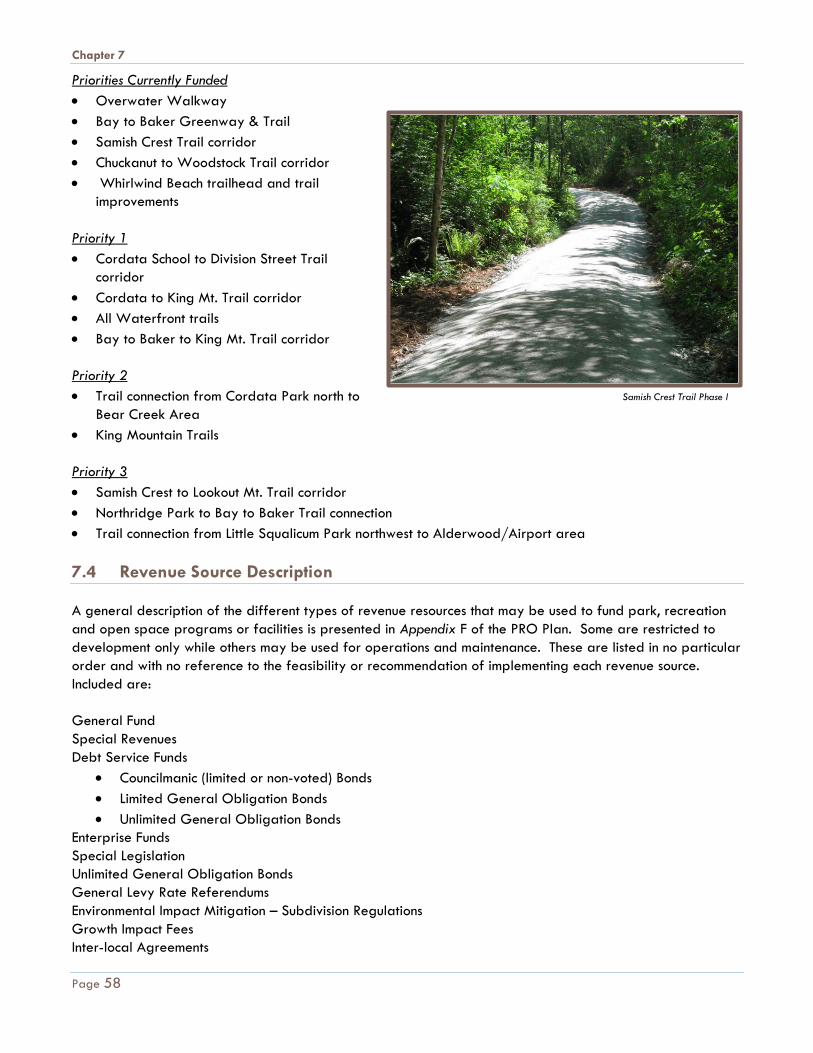
Chapter 7
Priorities Currently Funded • Overwater Walkway • Bay to Baker Greenway & Trail • Samish Crest Trail corridor • Chuckanut to Woodstock Trail corridor • Whirlwind Beach trailhead and trail
improvements Priority 1 • Cordata School to Division Street Trail
corridor • Cordata to King Mt. Trail corridor • All Waterfront trails • Bay to Baker to King Mt. Trail corridor Priority 2 • Trail connection from Cordata Park north to
Bear Creek Area • King Mountain Trails Priority 3 • Samish Crest to Lookout Mt. Trail corridor • Northridge Park to Bay to Baker Trail connection • Trail connection from Little Squalicum Park northwest to Alderwood/Airport area 7.4 Revenue Source Description A general description of the different types of revenue resources that may be used to fund park, recreation and open space programs or facilities is presented in Appendix F of the PRO Plan. Some are restricted to development only while others may be used for operations and maintenance. These are listed in no particular order and with no reference to the feasibility or recommendation of implementing each revenue source. Included are: General Fund Special Revenues Debt Service Funds
• Councilmanic (limited or non-voted) Bonds • Limited General Obligation Bonds • Unlimited General Obligation Bonds
Enterprise Funds Special Legislation Unlimited General Obligation Bonds General Levy Rate Referendums Environmental Impact Mitigation – Subdivision Regulations Growth Impact Fees Inter-local Agreements
Samish Crest Trail Phase I
Page 58
Chapter 7
User Fees and Charges Special Funding Sources
• REET (Real Estate Excise Tax) • Greenway Funds • LIFT (Local Infrastructure Financing Tool)
State Grants • Washington Wildlife Recreation Program (WWRP) • Aquatic Lands Enhancement Account (ALEA) • Salmon Recovery Funding • Capital Projects Fund for Washington Heritage • Boating Facilities Program • Washington State Public Works Commission • Youth Athletic Facilities (YAF) • Non-Highway & Off-Road Vehicle Activities Program (NOVA) • Firearms and Archery Range Recreation Program (FARR)
Federal Grants • NPS (National Park Service) grants • Transportation Enhancement Grants • National Recreational Trails Program (NRTP) • Boating Infrastructure Grant Program (BIG)
Recreation Service Districts (RCW Chapter 36.69) Metropolitan Park Districts (SB 2557)
• Chuckanut Community Forest Park District was established in 2013 for the specific purpose of raising funds to pay back the loan used to acquire Fairhaven Highlands.
Special Use Agreements Public/Private Service Contracts Public/Private Concessions Public/Private Joint Development Ventures Self-help Land Leases Self-help Contract Agreements
Page 59

A1
Appendix A P A R K
C L A S S I F I C A T I O N S
The intent of parks and recreation classifications is to aid in making acquisition and design decisions for park sites, facilities and the organization of recreation space which is responsive to public needs, creates quality recreational experiences and facilities that can be effectively maintained. Park classifications are primarily based on National Parks and Recreation Association (NRPA) guidelines and consider types of uses, size and relative service area of each park. The classifications used in Bellingham include:
1. Parks & Recreation a. Neighborhood Parks b. Community Parks c. Special Use Sites
2. Open Space 3. Trails
The guidelines below are for general purposes only. Actual acquisition and/or development of a park site will depend on several factors which should be considered in connection with classification guidelines when making planning decisions. These can include goals or needs for a given area, usually defined through a community process, or site-specific information such as topography, critical areas, access, zoning regulations, etc., that may limit the use of a given site. Park classifications establish several essential elements for park land based generally on the types of recreational uses and services to be provided. The following describes the park classifications for Bellingham, generally modified from the NRPA standards to reflect the Bellingham community preferences. In all cases, the approximate size of each park type shown below is a general parameter only. Actual size should be based on the land area needed to accommodate desired uses. Service areas shown may also vary as physical characteristics, such as topography or major roadways, may reduce the service area if access is limited by these factors. Park lighting and general crime prevention through environmental design (CPTED) principles should also be considered during the design process to
promote safety and security within park settings.
A2
Neighborhood Parks
1. General Description: A neighborhood park is the basic recreational focus and center of a
neighborhood. They should be developed for both active and passive recreation activities
geared specifically for those living within the service area. They should also accommodate a
wide variety of age and user groups, including children, adults, seniors and special populations.
Creating a sense of place by bringing together the unique character of the site with that of the
neighborhood is vital to successful neighborhood park design.
2. Approximate Size: 2 to 10 acres.
3. Service Area: ½ mile radius.
4. Acquisition Guidelines: Neighborhood parks should be centrally located within the neighborhood
it serves. Vehicular access may be provided through arterial roadways or local neighborhood
streets. Citizens should be able to walk to these parks without having to cross a major arterial
street. Some portion of the total acreage should be upland "developable" land of a size
sufficient to support the desired uses for that neighborhood.
5. Development Guidelines: Since each neighborhood is unique, neighborhood input should be used
to determine the development program for the park. In general, development should provide a
balance between active and passive recreation uses and should represent the characteristics and
context of the community in which it is located. Where active recreation is provided, it should be
intended for primarily informal, unstructured activities, or smaller programmed activities that will
not overburden the supporting infrastructure (parking, restroom, etc.). The following activities are
intended to serve as a general guideline only:
a. Parking - generally limited to around 2-10 stalls. While the intent is for neighborhood
parks to be walkable to most residences in the area it serves, parking may still be needed
to support those uses that need greater assistance, such as seniors or those with disabilities.
Americans with Disabilities Act (ADA) requirements should be met in all cases. On street
parking may be used to meet these criteria.
b. Site Furnishings - such as bike racks, benches, trash receptacles, park signage, picnic tables and drinking fountains.
c. Restrooms - may be provided where space and funding allow. This could include
permanent, semi-permanent or portable facilities.
d. Play Area - with climbing structures, swings or other similar elements, designed for a
variety of ages and abilities.
e. Picnic - tables, barbecue and/or small group shelters.
A3
f. Open grass lawn areas.
g. Sport facilities - compatible with neighborhood setting and park site constraints, such as: • Basketball: half court or full court • Volleyball, tennis, bocce ball, pickleball • Softball/baseball field (informal or youth) • Soccer field (informal or youth)
h. Other - features as need or site conditions allow that may help create diversity and a
unique character to each individual park. These may include public art, skateboard
elements, climbing walls, or other similar elements. Where provided, these should
generally be smaller in nature to fit the scale and context of the neighborhood park
setting.
Community Parks
1. General Description: Community parks are larger in size and are intended to serve a broader
range of activities and users. Their focus is on meeting the recreation needs of several
neighborhoods with more specialized activities, as well as preserving unique landscapes, open
spaces or environmental features. They allow for group activities and offer other recreation
opportunities not generally found at a neighborhood level. Due to their larger size, they are
often designed to serve a neighborhood park function as well and generally include all of the
same neighborhood park activities as well as additional unique characteristics described above.
2. Approximate size: 20-60 acres.
3. Service Area: 1 mile radius.
4. Acquisition Guidelines: The land available for anticipated uses and the quality of the natural
resource base should play a defining role in locating potential community park sites. They should
be located adjacent to a major arterial or other collector street to provide easy vehicular as well
as pedestrian and other multi-modal access. The proximity of other park types should also be
considered as the types of activities found in a community park may overlap with other park
functions. Some portion of the total acreage should be "developable" land of a size sufficient to
support the desired uses for that park.
5. Development Guidelines: Surrounding neighborhood and larger community or city-wide input
should be used to determine the development program for a community park. In general,
development should provide a balance between active and passive recreation uses and should
represent the characteristics and context of the community in which it is located. Where active
recreation is provided, it is generally intended for larger programmed activities such as sports
league practices, games and/or tournaments. Active recreation, such as sports fields, in community
parks may have additional support facilities not found at a neighborhood level, such as bleachers,

A4
fencing, dugouts, concessions, synthetic turf and/or lighting. The following activities are in addition
to neighborhood park guidelines and are intended to serve as a general guideline only:
a. Parking - generally larger in size to support more organized activities and larger group
events. May be anywhere from 20-80 or more stalls depending on the intended uses.
b. Restrooms - should generally be provided and should provide permanent facilities where feasible. Additional portable facilities may be needed during peak season or for special
organized events.
c. Picnic - larger group shelters that can be programmed and/or rented out for special
events.
d. Specialized Uses - that may not be feasible to provide in every neighborhood park. These
may include:
• Spray park
• Skateboard Park
• Off leash area
• Fishing docks or piers
• Waterfront access
• Regional trail connections
• Education/demonstration areas
• Outdoor stage/amphitheater
e. Concessions/Vendors - for food, beverage, rentals, etc. as feasible and demand allows.
Regional Parks
1. General Description: Regional parks are generally the largest in size and serve the greatest
geographical area, often extending beyond the city or urban growth area limits to include county
and/or other adjacent jurisdictions. Their focus is on providing specialized activities, as well as
preserving unique landscapes, open spaces or environmental features. They allow for group
activities and offer other recreation opportunities not generally found at a community or
neighborhood park level. They may also be designed to serve a community or neighborhood
park function as well, but are often of a more specialized nature. Bellingham currently has not
parks with this designation.
2. Approximate Size: 80 acres or more.
3. Service Area: 5 mile radius or more (as needed).

A5
4. Acquisition Guidelines: Regional park facilities, because they span many jurisdictions, should be
acquired jointly with other agency support when feasible, such as county, school district, port
authority, preservation groups and/or other adjacent jurisdictions. They should be situated such
that sufficient infrastructure could be developed or already exists to support a large number of
visitors, including major arterials, buses and other mass transit capabilities. They should also have
access to multi-modal connections.
5. Development Guidelines: Regional parks should be developed to maximize their intended uses,
whether for sports fields, mountain biking trails, camping, unique natural or environmental
features, or extreme sport venues. They may include the same activities as those found in
community and neighborhood park guidelines, but are often intended for a more single,
specialized use that requires a larger space than can be supported through a typical community
or neighborhood park type. Activities provided will depend solely on the type of intended uses
for the park and the influence of the community or region as expressed through a public process,
so are not listed individually with this section.
Special Use Sites
1. General Description: The special use classification covers a broad range of parks and recreation
facilities oriented toward a single-purpose use. They often fall into three general categories:
• Cultural Facilities - unique resources offering historical, educational, visual/performance art or
other similar experiences. These include museums, theaters, galleries, libraries and other civic
sites.
• Indoor Facilities - geared toward indoor uses, such as gymnasiums, community centers,
teen/senior centers, aquatic centers, ice arenas, etc.
• Unique Sites - generally a single use, but smaller than a regional park and not necessarily of a
significance that might draw from a larger regional base. These may include arboretums,
cemeteries, plazas, sports stadiums, farmer's markets, marinas, etc. - especially when they are
not in conjunction with other typical park amenities.
2. Approximate Size: Varies.
3. Service Area: Varies.
4. Acquisition Guidelines: As specialized, single use facilities, special use parks should be selected
based on the function that they are intended to serve. They should be situated such that sufficient
infrastructure could be developed or already exists to support the intended use, including major
arterials, buses and other mass transit capabilities as necessary. They should also have access to
multi-modal connections.

A6
5. Development Guidelines: Special use parks should be developed to maximize their intended uses.
They generally do NOT include the same activities as those found in other park types. Activities
provided will depend solely on the type of intended uses for the park and the influence of the
community or region as expressed through a public process, so are not listed individually with this
section.
Open Space
1. General Description: Open space sites are generally lands set aside for preservation of
significant natural resources, landscapes, open space and visual aesthetic or buffering functions.
One of the major purposes is to enhance the livability and character of a community by
preserving as many of its natural amenities as possible, as well as providing wildlife habitat in
urbanized areas. These may include both individual sites that exhibit natural resources, or lands
that are unsuitable for development but that offer other natural resource potential. Examples
include sites with steep slopes, old or second growth forests, wetlands, stream corridors, tidelands,
shorelines (salt or fresh water), storm water features, and/or watershed or aquifer recharge
zones.
2. Approximate Size: Varies.
3. Service Area: Varies.
4. Acquisition Guidelines: The quality of the natural resource should play a defining role in locating
potential open space sites and may be quite different than other park classifications. For
example, they may not necessarily need good access, vehicular or multi-modal, if they are
intended for preservation purposes. Limited access in this case may be more desirable. For the
same reason, there is not the same need for "developable" land unless the site is intended for
regional trailheads, interpretive facilities, environmental learning center, conference/retreats or
other similar auxiliary uses. Therefore, acquisition guidelines are much more flexible to respond to
opportunities as they may become available.
Sites that connect to other parks, open space or natural features should be considered, as well as
those that provide wildlife corridors through urban or urbanizing areas, though no priority is
intended in these guidelines, unless stated otherwise in other sections of this plan.
Preservation techniques beyond simple fee acquisition should also be considered, such as
preservation easements, dedications, conservation grants or programs, trusts, development
regulations and zoning codes. Tax incentives, density bonuses and other "trade-offs" should be
considered to help encourage these types of alternative preservation techniques.
5. Development Guidelines: Because open space sites serve primarily a preservation function,
development should be limited. Access, where provided, may include trails, minor trailhead
and/or educational features. Because of the limited nature of development on these sites, specific
activities are not listed individually in this section.

A7
Trails
1. General Description: While trails may be categorized into many different types, for the purpose
of this plan, trails is limited to generally include off-road multi-use trails only. Trails within parks
are shown in individual park development plans and on-street non-motorized facilities (sidewalks
and bikeways) are included in the transportation element of the Comprehensive Plan. Trails in this
context are intended to form a network of connections in and around the planning area, between
neighborhoods and parks, schools, open space, civic facilities and commercial centers.
2. Approximate Size: Varies (linear); generally 25'-50' wide.
3. Service Area: ½ mile radius.
4. Acquisition Guidelines: Trails should be located within open space or greenway corridors
whenever possible. They may also be located adjacent to streams, stream corridors or within
utility right-of-ways, abandoned railroad corridors or expanded roadway networks where they
can be separated from vehicular traffic by landscape or other natural features. Larger areas
may be needed at key locations along trail corridors to support trailhead development as
outlined below. Trails should be considered an integral part of the transportation network.
5. Development Guidelines: In general, trail development should meet local and state departments
of transportation of public works standards, as needed. They should also consider AASHTO
guidelines and ADA accessibility requirements. Consideration should be given to the trail
surfacing and drainage patterns early in the design process. The following activities may be
included with supporting trailhead development, as feasible, and is intended to serve as a
general guideline only:
a. Parking - generally limited to around 2-5 stalls unless at a major trailhead location when more
parking may be anticipated. On street parking may be used to meet these criteria.
b. Site Furnishings- such as benches, trash receptacles, wayfinding signage, picnic tables and
drinking fountains.
c. Restrooms - may be provided where space and funding allow. This could include permanent,
semi-permanent or portable facilities.
d. Other - features as needs or site conditions allow.

A8
B1
Appendix B E X I S T I N G
FAC I L I T I E S
TA B L E S
See the attached tables of Existing Facilities, both within and outside the planning area as referenced in Chapter 3 of the Parks, Recreation and Open Space Comprehensive Plan.
Various sources and data are used to calculate existing and proposed land and facility costs including:
• Recent public land acquisition costs
• Real estate digest database of Bellingham area recent vacant land sales
• Professional Real Estate Appraisal services
• Land valuation comparisons - Whatcom County Assessor information
• Public agency bid data including Parks and Recreation, Public Works and Washington State Department of Transportation
• Building Industry Association of Washington construction data
• Means Construction Cost data
• Independent Cost Estimators
• Consultant cost databases
• Contractor information
• Construction trend information
The following abbreviations are used in the tables: * Facility not shown on maps in plan AC Acre AQ Aquatic Land BSD Bellingham School District BTC Bellingham Technical College COB City of Bellingham CP Community Park EA Each LF Linear Foot NP Neighborhood Park N/A Not Applicable OS Open Space PRI Private POB Port of Bellingham ROW Right-of-Way ROS Right-of-Way Streetscape SU Special Use Site SF Square Foot TR Trail X Facility Exists but is not quantitatively defined UGA Urban Growth Area WCC Whatcom Community College WWU Western Washington University WA Washington State

B2

EXISTING FACILITIESCITY OF BELLINGHAM
(Within Planning Area)
Name Land
(acr
es)
Des
igna
tion
Ow
ners
hip
Trai
l (m
iles)
Picn
ic S
helte
rs (e
a)
Play
grou
nd (e
a)
Res
troo
ms
(ea)
Bas
ketb
all (
ea)
Volle
ybal
l - s
and
(ea)
Tenn
is/P
ickl
ebal
l (ea
)
Foot
ball/
Trac
k/St
adiu
m in
cl F
ield
&
Res
troo
ms
(ea)
Mul
ti U
se F
ield
(ea
)
Bas
ebal
l/Sof
tbal
l lig
hted
(ea)
Bas
ebal
l Sta
dium
incl
. Fie
ld
&R
estr
oom
s (e
a)
Skat
e Pa
rk (e
a)
Off-
Leas
h A
rea
(acr
es),
X =
desi
gnat
ed, n
ot d
evel
oped
)
Bea
ch (e
a) x
=uni
mpr
oved
acc
ess
Boa
t Lau
nch
(ram
p)
Han
d B
oat L
aunc
h
Swim
min
g/A
quat
ic (s
f)
Com
mun
ity C
ente
r / M
eetin
g R
oom
(sf)
2013
- inc
lude
s w
hole
bui
ldin
gs,
incl
. sto
rage
, etc
. VFA
#
Info
rmal
Law
n A
rea
(acr
es)
Doc
k/Pi
er (l
f)
Park
ing
Lot (
num
ber i
ndic
ates
st
riped
lots
) (ot
herw
ise
grav
el)
Aud
itoriu
m/A
mph
ithea
ter/S
tage
(e
a, o
utdo
or)
Con
cess
ions
(sf)
Com
mun
ity G
arde
ns (e
a)
Trai
lhea
d Pa
rkin
g (e
a) X
=inc
lude
d w
ith o
ther
par
king
Dis
c G
olf (
ea)
Spra
y Pa
rk (e
a)
EXISTINGBloedel Donovan Park (land) 28.4 CP COB 0.2 1 1 1 1 X 1 1 1 10,800 10,033 4.4 243 xBloedel Donovan Park (water) 12.1 AQU
Boulevard Park 14.9 CPCOB/WC/RR 1.8 1 2 1 1 2 105 0.5 2,161 x
Boulevard Park (water) 5.6 CP/AQU 1,260Civic Athletic Complex 83.0 CP COB 1.3 1 4 1 6 1 1.5 20,003 20,000 938 xCordata Community Park 20.8 CP COBCornwall Park 69.0 CP COB 3.4 2 2 2 1 4 1 5 186 1 1Cornwall Beach Park 14.0 CP NRFairhaven Park 136.9 CP COB 1 1 1 1 1 2 1 1,200 2599 (+) 2.5 91 x 1
Lake Padden Park (land/not Golf) 575.0 CP COB 9.8 2 1 3 1 2 2 2.2 1 1 1 1.4 285 367 1Lake Padden Park (water) 151.0 CP/AQULake Padden Golf Course 205.0 SU COB 1 9,980 157 4,252
Maritime Heritage Park 13.0 CP COB 1.5 1,600 1,809 1.5 27 1Northridge Park 38.8 CP COB 2.2 3Squalicum Creek Park 35.5 CP COB 0.74 3 1 2 1 1 2 1 1 2 56 XVanWyck Park 19.9 CP COB 0
Whatcom Falls Park 365.0 CP COB 6.8 2 2 2 1 2 X 3 40 104 XBirchwood Park 4.0 NP COB 0.2 1 1 1 1 2 11Broadway Park 6.8 NP COB 0.1 1 1 1 1 4.3Carl Lobe Park 0.6 NP COB 1 1Cordata Park 19.2 NP COB 0.7Cornwall Tot Lot 0.3 NP COB 1Elizabeth Park 4.5 NP COB 0.4 1 1 1 2 Gazebo 0.5
Fairhaven Village Green 0.4 NP COB 3 1 0.1 0.5Forest and Cedar Park 1.6 NP COB 0.1 1 1 0.5 0.5Fouts Park 1.2 NP COB 1 0.4Franklin Park 2.0 NP COB 0.4 1 1 0.25 0.7Happy Valley Park 5.1 NP COB 0.3 1 1 0.5Highland Heights Park 1.1 NP COB 1 1 0.7Laurel Park 2.1 NP COB 1 0.5 0.6 7Lorrainne Ellis Park 0.5 NP COB 1 0.5
Maplewood/McLeod Park (Potts) 5.8 NP COB 0.1Memorial Park 6.2 NP COB 0.5 0.7
N. Samish Crest Park 0.0 NP COB 0Ridgemont Park 1.0 NP COB 1 1 0.4
Rock Hill Park 1.2 NPCOB/W
Asidewalks 1 0.5 X
Roosevelt Park 7.2 NP COB 0.5 1 1 1 1 0.25 2.8 9

EXISTING FACILITIESCITY OF BELLINGHAM
(Within Planning Area)
Name Land
(acr
es)
Des
igna
tion
Ow
ners
hip
Trai
l (m
iles)
Picn
ic S
helte
rs (e
a)
Play
grou
nd (e
a)
Res
troo
ms
(ea)
Bas
ketb
all (
ea)
Volle
ybal
l - s
and
(ea)
Tenn
is/P
ickl
ebal
l (ea
)
Foot
ball/
Trac
k/St
adiu
m in
cl F
ield
&
Res
troo
ms
(ea)
Mul
ti U
se F
ield
(ea
)
Bas
ebal
l/Sof
tbal
l lig
hted
(ea)
Bas
ebal
l Sta
dium
incl
. Fie
ld
&R
estr
oom
s (e
a)
Skat
e Pa
rk (e
a)
Off-
Leas
h A
rea
(acr
es),
X =
desi
gnat
ed, n
ot d
evel
oped
)
Bea
ch (e
a) x
=uni
mpr
oved
acc
ess
Boa
t Lau
nch
(ram
p)
Han
d B
oat L
aunc
h
Swim
min
g/A
quat
ic (s
f)
Com
mun
ity C
ente
r / M
eetin
g R
oom
(sf)
2013
- inc
lude
s w
hole
bui
ldin
gs,
incl
. sto
rage
, etc
. VFA
#
Info
rmal
Law
n A
rea
(acr
es)
Doc
k/Pi
er (l
f)
Park
ing
Lot (
num
ber i
ndic
ates
st
riped
lots
) (ot
herw
ise
grav
el)
Aud
itoriu
m/A
mph
ithea
ter/S
tage
(e
a, o
utdo
or)
Con
cess
ions
(sf)
Com
mun
ity G
arde
ns (e
a)
Trai
lhea
d Pa
rkin
g (e
a) X
=inc
lude
d w
ith o
ther
par
king
Dis
c G
olf (
ea)
Spra
y Pa
rk (e
a)
S. Samish Crest Park 0.0 NP COB 0Shuksan Meadows Park 0.7 NP BSD alks 1 0.1 6St. Clair Park 3.7 NP COB alks 1 1 0.6 7Sunnyland Park 0.8 NP COB alks 1 0.3Sunset Pond Park 2.6 NP COB 0.3 X 0.5 X
Arroyo Nature Area 85.9 OSCOB/P
P 2.6 X X x
Bakerview Open Space 7.0 OSCOB/R
OW 0.6Barkley Greenway & Trail 4.9 TR/OS COB 0.7Barkley Woods* 0.2 OS COB 0Bay to Baker Greenway & Trail 7.4 TR/OS COB 1.3
Bear Creek Open Space 87.5 OS COBBellingham High School trail easement * 0.1 OS BSDBig Rock Open Space 10.9 OS COB 1
Cemetery Creek Greenway 6.4 OS COB 0Central Waterfront Walkway 0.0 TR/OS Port 0.57Chuckanut Bay Open Space & Tidelands (land) 49.7 OS COB 0.1 1 1Chuckanut Bay Open Space & Tidelands (water) 76.1 AQUConnelly Creek Nature Area 29.5 OS COB 1.2Cordata Open Space 31.7 OS COB 0.6East Meadow Park * 0.9 OS COB 0.1
Euclid Park (land) 17.8 OS COB 0.2 x XEuclid Park (water) 3.1 AQU
Galbraith Mountain 51.4 OS COB 1.2 9 1Hawley Open Space* 15.0 OS COB 0
Interurban Greenway & Trail 112.9 TR/OSCOB/P
SE 3 17 1
King/Queen Mountain Open Space 37.0 OS COB 0Klipsun Greenway & Trail 18.1 TR/OS COB 1.2
Laurelwood Trail Open Space* 0.6 TR/OSCOB/R
OW 0.4Lazy E Ranch 2.3 OS COB 0Lenora Court Open Space * 0.1 OS COBLincoln Creek Open Space* 1.3 OS COB 0
Little Squalicum Park 25.8 OSCOB/WC/ BTC 1.2 X x 14 x
Lowell Open Space 5.5 OS COB 0.3

EXISTING FACILITIESCITY OF BELLINGHAM
(Within Planning Area)
Name Land
(acr
es)
Des
igna
tion
Ow
ners
hip
Trai
l (m
iles)
Picn
ic S
helte
rs (e
a)
Play
grou
nd (e
a)
Res
troo
ms
(ea)
Bas
ketb
all (
ea)
Volle
ybal
l - s
and
(ea)
Tenn
is/P
ickl
ebal
l (ea
)
Foot
ball/
Trac
k/St
adiu
m in
cl F
ield
&
Res
troo
ms
(ea)
Mul
ti U
se F
ield
(ea
)
Bas
ebal
l/Sof
tbal
l lig
hted
(ea)
Bas
ebal
l Sta
dium
incl
. Fie
ld
&R
estr
oom
s (e
a)
Skat
e Pa
rk (e
a)
Off-
Leas
h A
rea
(acr
es),
X =
desi
gnat
ed, n
ot d
evel
oped
)
Bea
ch (e
a) x
=uni
mpr
oved
acc
ess
Boa
t Lau
nch
(ram
p)
Han
d B
oat L
aunc
h
Swim
min
g/A
quat
ic (s
f)
Com
mun
ity C
ente
r / M
eetin
g R
oom
(sf)
2013
- inc
lude
s w
hole
bui
ldin
gs,
incl
. sto
rage
, etc
. VFA
#
Info
rmal
Law
n A
rea
(acr
es)
Doc
k/Pi
er (l
f)
Park
ing
Lot (
num
ber i
ndic
ates
st
riped
lots
) (ot
herw
ise
grav
el)
Aud
itoriu
m/A
mph
ithea
ter/S
tage
(e
a, o
utdo
or)
Con
cess
ions
(sf)
Com
mun
ity G
arde
ns (e
a)
Trai
lhea
d Pa
rkin
g (e
a) X
=inc
lude
d w
ith o
ther
par
king
Dis
c G
olf (
ea)
Spra
y Pa
rk (e
a)
Lower Padden Creek Open Space & Trails 19.6 TR/OS COB 0.7Mian Shores LLA Tract* 0.4 OS COB 0Miscellaneous Tracts* 0.2 OS COBNorth Bay Open Space (Holmes 2013) 0.4 OS COB
North Bay Open Space (Neher 2013) 1.0 OS COB
North Bay Open Space (land) 30.0 OS COB 0.1North Bay Open Space (water) 7.5 OS/AQUOld Village Trail* 0.2 TR ROW 0.5Orchard Estates Wetlands 14.5 OS COBOther Right-of-Way* 12.9 OS/ROS COB 1
Padden Gorge 33.2 OS COB 0.8Padden Lake Hills Open Space* 0.7Palakika Trail 0.9 TR/OS COB 0.25Peabody Plaza * 0.4 OS COB 0Post Point Treatment Plant Open Space 15.8 OS COB 0.7 X X
Railroad Greenway & Trail 50.4 TR/OS COB 4.7Salmon Woods Open Space 45.1 OS COB 1
Samish Crest Open Space 192.9 OS COB 1.25
Sehome Hill Arboretum 137.2 OS COB 6.4 X overlook 4
Silver Creek Open Space (land) 1.3 OSWA DNR 0 X
Silver Creek Open Space (water) 0.9 AQUWA DNR
South Bay Greenway & Trail 16.6 TR/OS COB 1.7Spring Creek Nature Area 5.3 OS COB 0.1
Squalicum Creek Greenway & Trail 116.3 TR/OS COB 0.4
Sylvan Pond Open Space * 0.4 OS COB 0
Whatcom Creek Greenway & Trail (land) 40.3 TR/OS COB 2

EXISTING FACILITIESCITY OF BELLINGHAM
(Within Planning Area)
Name Land
(acr
es)
Des
igna
tion
Ow
ners
hip
Trai
l (m
iles)
Picn
ic S
helte
rs (e
a)
Play
grou
nd (e
a)
Res
troo
ms
(ea)
Bas
ketb
all (
ea)
Volle
ybal
l - s
and
(ea)
Tenn
is/P
ickl
ebal
l (ea
)
Foot
ball/
Trac
k/St
adiu
m in
cl F
ield
&
Res
troo
ms
(ea)
Mul
ti U
se F
ield
(ea
)
Bas
ebal
l/Sof
tbal
l lig
hted
(ea)
Bas
ebal
l Sta
dium
incl
. Fie
ld
&R
estr
oom
s (e
a)
Skat
e Pa
rk (e
a)
Off-
Leas
h A
rea
(acr
es),
X =
desi
gnat
ed, n
ot d
evel
oped
)
Bea
ch (e
a) x
=uni
mpr
oved
acc
ess
Boa
t Lau
nch
(ram
p)
Han
d B
oat L
aunc
h
Swim
min
g/A
quat
ic (s
f)
Com
mun
ity C
ente
r / M
eetin
g R
oom
(sf)
2013
- inc
lude
s w
hole
bui
ldin
gs,
incl
. sto
rage
, etc
. VFA
#
Info
rmal
Law
n A
rea
(acr
es)
Doc
k/Pi
er (l
f)
Park
ing
Lot (
num
ber i
ndic
ates
st
riped
lots
) (ot
herw
ise
grav
el)
Aud
itoriu
m/A
mph
ithea
ter/S
tage
(e
a, o
utdo
or)
Con
cess
ions
(sf)
Com
mun
ity G
arde
ns (e
a)
Trai
lhea
d Pa
rkin
g (e
a) X
=inc
lude
d w
ith o
ther
par
king
Dis
c G
olf (
ea)
Spra
y Pa
rk (e
a)
Whatcom Creek Greenway & Trail (water) 0.3 AQUBayview Cemetery 73.0 SU COB 0 mausoleum 5
Big Rock Garden 2.7 SU COB 0.5 1korean
memorial 7 X
Broadway Overlook * 0.3 SU ROW
Community Garden - Fairhaven * 0.4 SU COB 0 1
Community Garden - Happy Valley * 0.4 SU PRI 0 1Community Garden - Lakeway * 1.8 SU COB 0 1Cornwall Rose Garden 0.5 SU COB 0Fountain Plaza* 0.1 SU COB
Gibson Plaza * 0.2 SUCOB/R
OW 0
Gossage Gardens Plaza * 0.2 SU COB
Lee Memorial Park* 1.1 SU COB 0.3Park Admin Office-Cornwall 0.0 SU COB 0Park Shop Buildings - Woburn * 5.5 SU COB 0 15
Woodstock Farm (land) 13.0 SU COB 0.4 8,900 2Woodstock Farm (water) 1.4 AQU
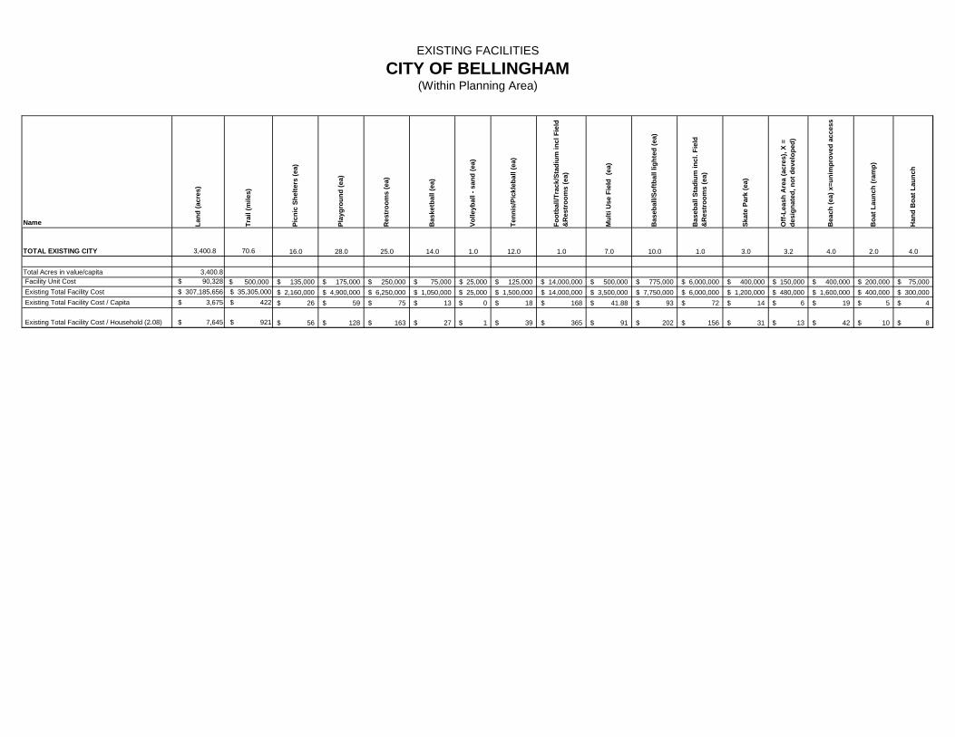
EXISTING FACILITIESCITY OF BELLINGHAM
(Within Planning Area)
Name Land
(acr
es)
Trai
l (m
iles)
Picn
ic S
helte
rs (e
a)
Play
grou
nd (e
a)
Res
troo
ms
(ea)
Bas
ketb
all (
ea)
Volle
ybal
l - s
and
(ea)
Tenn
is/P
ickl
ebal
l (ea
)
Foot
ball/
Trac
k/St
adiu
m in
cl F
ield
&
Res
troo
ms
(ea)
Mul
ti U
se F
ield
(ea
)
Bas
ebal
l/Sof
tbal
l lig
hted
(ea)
Bas
ebal
l Sta
dium
incl
. Fie
ld
&R
estr
oom
s (e
a)
Skat
e Pa
rk (e
a)
Off-
Leas
h A
rea
(acr
es),
X =
desi
gnat
ed, n
ot d
evel
oped
)
Bea
ch (e
a) x
=uni
mpr
oved
acc
ess
Boa
t Lau
nch
(ram
p)
Han
d B
oat L
aunc
h
TOTAL EXISTING CITY 3,400.8 70.6 16.0 28.0 25.0 14.0 1.0 12.0 1.0 7.0 10.0 1.0 3.0 3.2 4.0 2.0 4.0
Total Acres in value/capita 3,400.8 Facility Unit Cost $ 90,328 500,000$ 135,000$ 175,000$ 250,000$ 75,000$ 25,000$ 125,000$ 14,000,000$ 500,000$ 775,000$ 6,000,000$ 400,000$ 150,000$ 400,000$ 200,000$ 75,000$ Existing Total Facility Cost $ 307,185,656 $ 35,305,000 2,160,000$ 4,900,000$ 6,250,000$ 1,050,000$ 25,000$ 1,500,000$ 14,000,000$ 3,500,000$ 7,750,000$ 6,000,000$ 1,200,000$ 480,000$ 1,600,000$ 400,000$ 300,000$ Existing Total Facility Cost / Capita $ 3,675 $ 422 26$ 59$ 75$ 13$ 0$ 18$ 168$ 41.88$ 93$ 72$ 14$ 6$ 19$ 5$ 4$
Existing Total Facility Cost / Household (2.08) $ 7,645 $ 921 56$ 128$ 163$ 27$ 1$ 39$ 365$ 91$ 202$ 156$ 31$ 13$ 42$ 10$ 8$
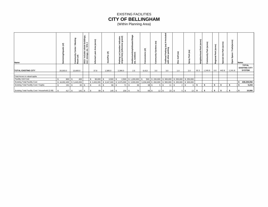
EXISTING FACILITIESCITY OF BELLINGHAM
(Within Planning Area)
Name
TOTAL EXISTING CITY
Total Acres in value/capita Facility Unit Cost Existing Total Facility Cost Existing Total Facility Cost / Capita
Existing Total Facility Cost / Household (2.08)
Swim
min
g/A
quat
ic (s
f)
Com
mun
ity C
ente
r / M
eetin
g R
oom
(sf)
2013
- inc
lude
s w
hole
bui
ldin
gs,
incl
. sto
rage
, etc
. VFA
#
Info
rmal
Law
n A
rea
(acr
es)
Doc
k/Pi
er (l
f)
Park
ing
Lot (
num
ber i
ndic
ates
st
riped
lots
) (ot
herw
ise
grav
el)
Aud
itoriu
m/A
mph
ithea
ter/S
tage
(e
a, o
utdo
or)
Con
cess
ions
(sf)
Com
mun
ity G
arde
ns (e
a)
Trai
lhea
d Pa
rkin
g (e
a) X
=inc
lude
d w
ith o
ther
par
king
Dis
c G
olf (
ea)
Spra
y Pa
rk (e
a)
Nei
ghbo
rhoo
d Pa
rk (a
cres
)
Com
mun
ity P
ark
(acr
es)
Reg
iona
l Par
k (a
cres
)
Spec
ial U
se P
ark
(acr
es)
Ope
n Sp
ace
/ Tra
ils(a
cres
)
Notes
20,003.0 13,600.0 37.8 1,585.0 2,390.0 2.5 6,413 3.0 3.0 1.0 2.0 92.3 1,245.9 0.0 442.8 1,241.8
TOTAL EXISTING CITY
SYSTEM
800$ 400$ 90,000$ 3,500$ 2,500$ 1,200,000$ 500$ 150,000$ 300,000$ 200,000$ 250,000$ 16,002,400$ 5,440,000$ 3,402,000$ 5,547,500$ 5,975,000$ 3,000,000$ 3,206,500 450,000$ 900,000$ 200,000$ 500,000$ $ 438,229,056
191$ 65$ -$ 41$ 66$ 71$ 36$ 38 5$ 11$ 2$ 6$ $ - $ - $ - $ - $ - $ 5,243
417$ 142$ -$ 89$ 145$ 156$ 78$ 84 12$ 23$ 5$ 13$ $ - $ - $ - $ - $ - $ 10,906
C1
Appendix C
P R O P O S E D
F A C I L I T I E S
T A B L E S
See the attached tables of Proposed Facilities, including
recommendations as referenced in Chapter 7 of the Parks, Recreation
and Open Space Comprehensive Plan.
Various sources and data are used to calculate existing and proposed
land and facility costs including:
Recent public land acquisition costs
Real estate digest database of Bellingham area recent vacant
land sales
Professional Real Estate Appraisal services
Land valuation comparisons - Whatcom County Assessor
information
Public agency bid data including Parks and Recreation, Public
Works and Washington State Department of Transportation
Building Industry Association of Washington construction data
Means Construction Cost data
Independent Cost Estimators
Consultant cost databases
Contractor information
Construction trend information
The following abbreviations are used in the tables:
* Facility not shown on maps in plan
AQ Aquatic Land
CP Community Park
NP Neighborhood Park
OS Open Space
SU Special Use Site
TR Trail

C2
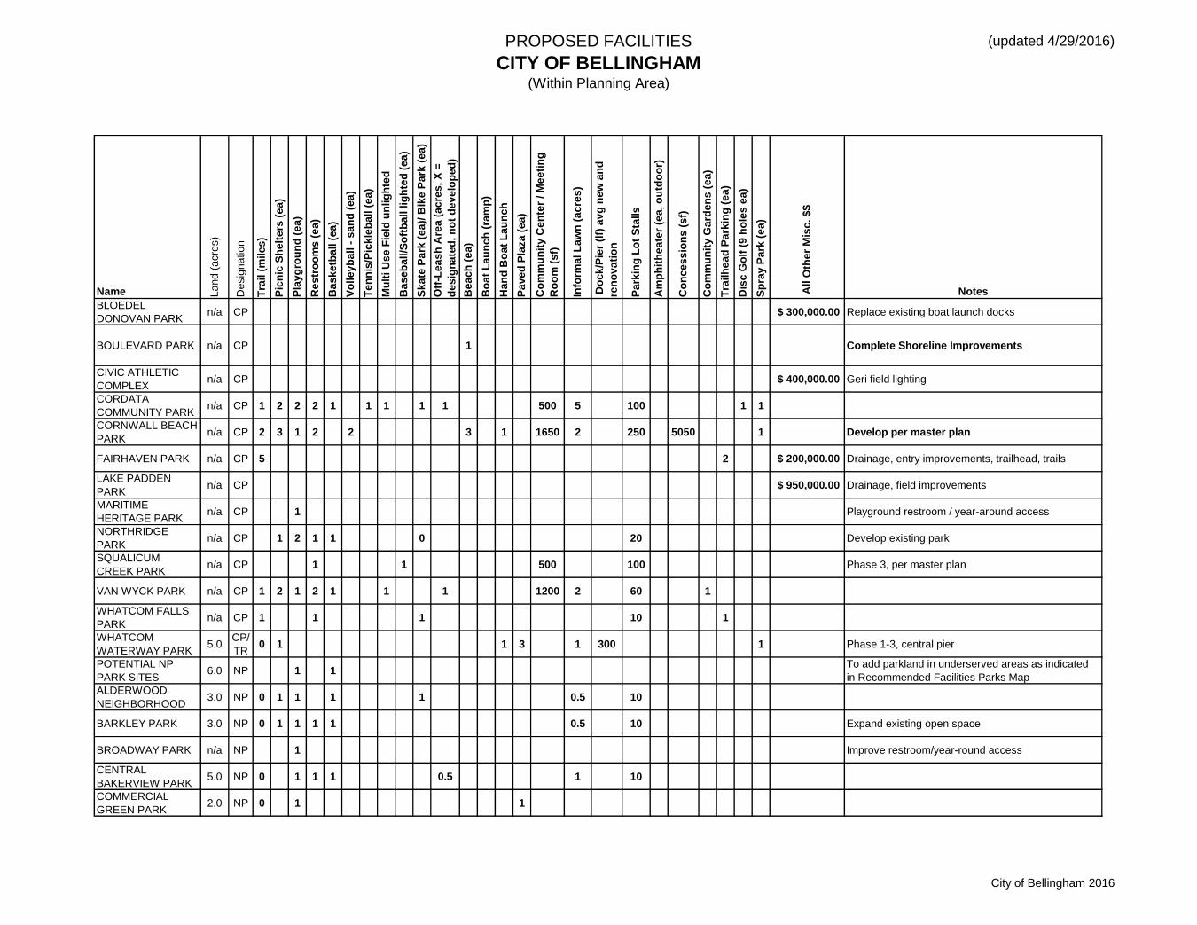
PROPOSED FACILITIES
CITY OF BELLINGHAM(Within Planning Area)
(updated 4/29/2016)
Name La
nd
(a
cre
s)
De
sig
na
tion
Tra
il (
mile
s)
Pic
nic
Sh
elt
ers
(e
a)
Pla
yg
rou
nd
(e
a)
Re
str
oo
ms
(e
a)
Ba
sk
etb
all (
ea
)
Vo
lle
yb
all -
sa
nd
(e
a)
Ten
nis
/Pic
kle
ball (
ea
)
Mu
lti U
se
Fie
ld u
nlig
hte
d
Ba
se
ball/S
oft
ball lig
hte
d (
ea
)
Sk
ate
Pa
rk (
ea
)/ B
ike
Pa
rk (
ea
)
Off
-Lea
sh
Are
a (
ac
res
, X
=
des
ign
ate
d, n
ot
dev
elo
ped
)
Be
ac
h (
ea
)
Bo
at
Lau
nc
h (
ram
p)
Ha
nd
Bo
at
Lau
nc
h
Pa
ve
d P
laza
(e
a)
Co
mm
un
ity
Ce
nte
r / M
ee
tin
g
Ro
om
(s
f)
Info
rma
l L
aw
n (
ac
res
)
Do
ck
/Pie
r (l
f) a
vg
new
an
d
ren
ova
tio
n
Pa
rkin
g L
ot
Sta
lls
Am
ph
ith
ea
ter
(ea
, o
utd
oo
r)
Co
nce
ss
ion
s (
sf)
Co
mm
un
ity
Ga
rde
ns (
ea
)
Tra
ilh
ea
d P
ark
ing
(e
a)
Dis
c G
olf
(9
ho
les
ea
)
Sp
ray
Pa
rk (
ea
)
All O
ther
Mis
c. $
$
Notes
BLOEDEL
DONOVAN PARKn/a CP $ 300,000.00 Replace existing boat launch docks
BOULEVARD PARK n/a CP 1 Complete Shoreline Improvements
CIVIC ATHLETIC
COMPLEXn/a CP $ 400,000.00 Geri field lighting
CORDATA
COMMUNITY PARKn/a CP 1 2 2 2 1 1 1 1 1 500 5 100 1 1
CORNWALL BEACH
PARKn/a CP 2 3 1 2 2 3 1 1650 2 250 5050 1 Develop per master plan
FAIRHAVEN PARK n/a CP 5 2 $ 200,000.00 Drainage, entry improvements, trailhead, trails
LAKE PADDEN
PARKn/a CP $ 950,000.00 Drainage, field improvements
MARITIME
HERITAGE PARKn/a CP 1 Playground restroom / year-around access
NORTHRIDGE
PARKn/a CP 1 2 1 1 0 20 Develop existing park
SQUALICUM
CREEK PARK n/a CP 1 1 500 100 Phase 3, per master plan
VAN WYCK PARK n/a CP 1 2 1 2 1 1 1 1200 2 60 1
WHATCOM FALLS
PARKn/a CP 1 1 1 10 1
WHATCOM
WATERWAY PARK 5.0
CP/
TR0 1 1 3 1 300 1 Phase 1-3, central pier
POTENTIAL NP
PARK SITES6.0 NP 1 1
To add parkland in underserved areas as indicated
in Recommended Facilities Parks Map
ALDERWOOD
NEIGHBORHOOD 3.0 NP 0 1 1 1 1 0.5 10
BARKLEY PARK 3.0 NP 0 1 1 1 1 0.5 10 Expand existing open space
BROADWAY PARK n/a NP 1 Improve restroom/year-round access
CENTRAL
BAKERVIEW PARK5.0 NP 0 1 1 1 0.5 1 10
COMMERCIAL
GREEN PARK2.0 NP 0 1 1
City of Bellingham 2016

PROPOSED FACILITIES
CITY OF BELLINGHAM(Within Planning Area)
(updated 4/29/2016)
Name La
nd
(a
cre
s)
De
sig
na
tion
Tra
il (
mile
s)
Pic
nic
Sh
elt
ers
(e
a)
Pla
yg
rou
nd
(e
a)
Re
str
oo
ms
(e
a)
Ba
sk
etb
all (
ea
)
Vo
lle
yb
all -
sa
nd
(e
a)
Ten
nis
/Pic
kle
ball (
ea
)
Mu
lti U
se
Fie
ld u
nlig
hte
d
Ba
se
ball/S
oft
ball lig
hte
d (
ea
)
Sk
ate
Pa
rk (
ea
)/ B
ike
Pa
rk (
ea
)
Off
-Lea
sh
Are
a (
ac
res
, X
=
des
ign
ate
d, n
ot
dev
elo
ped
)
Be
ac
h (
ea
)
Bo
at
Lau
nc
h (
ram
p)
Ha
nd
Bo
at
Lau
nc
h
Pa
ve
d P
laza
(e
a)
Co
mm
un
ity
Ce
nte
r / M
ee
tin
g
Ro
om
(s
f)
Info
rma
l L
aw
n (
ac
res
)
Do
ck
/Pie
r (l
f) a
vg
new
an
d
ren
ova
tio
n
Pa
rkin
g L
ot
Sta
lls
Am
ph
ith
ea
ter
(ea
, o
utd
oo
r)
Co
nce
ss
ion
s (
sf)
Co
mm
un
ity
Ga
rde
ns (
ea
)
Tra
ilh
ea
d P
ark
ing
(e
a)
Dis
c G
olf
(9
ho
les
ea
)
Sp
ray
Pa
rk (
ea
)
All O
ther
Mis
c. $
$
Notes
CORDATA PARK n/a NP 1 1 1 1 0 1 20 Develop existing park
DEWEY VALLEY
PARK1.0 NP 0 1 1 5
DOWNTOWN
SQUARE & PLAZAS1.0 NP 2 To be determined with redevelopment
E. YEW STREET
PARK3.0 NP 1 1 1 1 0 0.5 1 20
EAST BAKERVIEW
PARK5.0 NP 1 1 1 1 1 0 1
MAPLEWOOD
MCLEOD PARKN/A NP 0 1 1 1 1 5 Develop existing park
NW
NEIGHBORHOOD 2.0 NP 1 1 1 1 1 1 10
N SAMISH CREST
PARKn/a NP 1 1 1 1 1 0.5 2 10 Develop part of existing open space
S SAMISH CREST
PARKn/a NP 1 1 1 1 1
SUNSET POND
PARKn/a NP 1 1 1 1 0.5 1 0.5 40 Expand existing open space
WEST BAKERVIEW
PARK5.0 NP 1 1 1 0.5 1 10
ARROYO PARK n/a OS 1 $ 200,000.00 Improve N. Chuckanut trailhead, bridges
DEWEY VALLEY 10.0 OS 2
LITTLE SQUALICUM
PARKn/a OS 1 1 1800 20 Expand Parking, renovate pier
NW BELLINGHAM
OS10.0 OS 2
GALBRAITH
GREENWAY AND 4.0 OS 2 1 1 Jointly with County
WATERFRONT/TID
ELANDS6.0
OS/
AQVaries
I AND J
WATERWAY PARK1.0 SU 1 0.3 Phase 4
BIG ROCK GARDEN n/a SU 0 10 Improvements per master plan
COURTHOUSE
PLAZA0.3 SU 1 Per Old Town Neighborhood Plan
City of Bellingham 2016

PROPOSED FACILITIES
CITY OF BELLINGHAM(Within Planning Area)
(updated 4/29/2016)
Name La
nd
(a
cre
s)
De
sig
na
tion
Tra
il (
mile
s)
Pic
nic
Sh
elt
ers
(e
a)
Pla
yg
rou
nd
(e
a)
Re
str
oo
ms
(e
a)
Ba
sk
etb
all (
ea
)
Vo
lle
yb
all -
sa
nd
(e
a)
Ten
nis
/Pic
kle
ball (
ea
)
Mu
lti U
se
Fie
ld u
nlig
hte
d
Ba
se
ball/S
oft
ball lig
hte
d (
ea
)
Sk
ate
Pa
rk (
ea
)/ B
ike
Pa
rk (
ea
)
Off
-Lea
sh
Are
a (
ac
res
, X
=
des
ign
ate
d, n
ot
dev
elo
ped
)
Be
ac
h (
ea
)
Bo
at
Lau
nc
h (
ram
p)
Ha
nd
Bo
at
Lau
nc
h
Pa
ve
d P
laza
(e
a)
Co
mm
un
ity
Ce
nte
r / M
ee
tin
g
Ro
om
(s
f)
Info
rma
l L
aw
n (
ac
res
)
Do
ck
/Pie
r (l
f) a
vg
new
an
d
ren
ova
tio
n
Pa
rkin
g L
ot
Sta
lls
Am
ph
ith
ea
ter
(ea
, o
utd
oo
r)
Co
nce
ss
ion
s (
sf)
Co
mm
un
ity
Ga
rde
ns (
ea
)
Tra
ilh
ea
d P
ark
ing
(e
a)
Dis
c G
olf
(9
ho
les
ea
)
Sp
ray
Pa
rk (
ea
)
All O
ther
Mis
c. $
$
Notes
DEPOT PLAZA 0.3 SU 1 per Old Town Neighborhood Plan
FOUNTAIN
SQUARE PLAZAn/a SU 1 $ 300,000.00 Improvements
WOODSTOCK
FARMn/a SU 0 1 10 Improve access, hand boat landing (no launch)
I-5 TRAIL
CROSSINGS *0.6 TR 0
Tunnel, bridge, etc. Assumes three: Padden,
Squalicum & Bakerview
BAY TO BAKER
GREENWAY & 10.9
TR/
OS3 Complete trail
BAY TO BAKER TO
KING MTN 4.1
TR/
OS2
CHUCKANUT TO
WOODSTOCK 1.0
TR/
OS1 1
CORDATA TRAILS 5.0TR/
OS1
INTERURBAN
GREENWAY & n/a
TR/
OS2 1 Chuckanut Community Forest
KING MTN
GREENWAY AND 10.0
TR/
OS2
N BELLINGHAM
GREENWAY & 75.0
TR/
OS10 3 All trails per master plan
NORTH BAY
GREENWAY & 6.0
TR/
OS2 North-South connection, assumes two
OVER WATER
WALKWAYn/a
TR/
OS1 2400
S. BAY GREENWAY
& TRAIL*3.0
TR/
OS1
SAMISH CREST
GREENWAY & 4.0
TR/
OS3
Trailheads assumed with Samish Crest Park (north
and south)
PADDEN TO I-5
GREENWAY AND 2.4
TR/
OS1
SAMISH CREST TO
LOOKOUT MT. 2.4
TR/
OS1
SEHOME BLUFF
TRAIL - 0.2
TR/
OS1
WHATCOM CREEK
GREENWAY & 1.0
TR/
OS1 Complete system
YEW GREENWAY &
TRAIL*5.0
TR/
OS1
City of Bellingham 2016
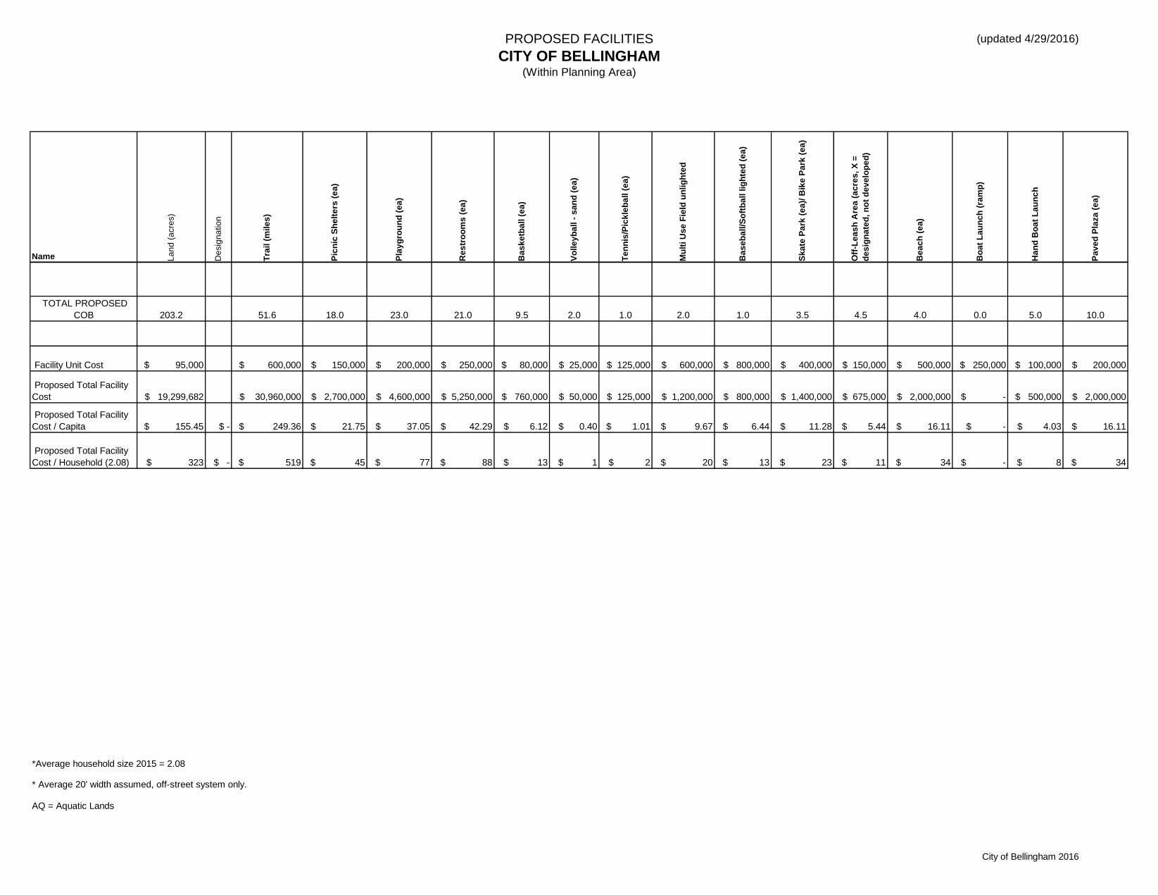
PROPOSED FACILITIES
CITY OF BELLINGHAM(Within Planning Area)
(updated 4/29/2016)
Name La
nd
(a
cre
s)
De
sig
na
tio
n
Tra
il (
mile
s)
Pic
nic
Sh
elt
ers
(e
a)
Pla
yg
rou
nd
(e
a)
Re
str
oo
ms
(e
a)
Ba
sk
etb
all (
ea
)
Vo
lle
yb
all -
sa
nd
(e
a)
Te
nn
is/P
ick
leb
all (
ea
)
Mu
lti U
se
Fie
ld u
nlig
hte
d
Ba
se
ba
ll/S
oft
ba
ll lig
hte
d (
ea
)
Sk
ate
Pa
rk (
ea
)/ B
ike
Pa
rk (
ea
)
Off
-Le
as
h A
rea
(a
cre
s, X
=
de
sig
na
ted
, n
ot
de
ve
lop
ed
)
Be
ac
h (
ea
)
Bo
at
La
un
ch
(ra
mp
)
Ha
nd
Bo
at
La
un
ch
Pa
ve
d P
laza
(e
a)
TOTAL PROPOSED
COB 203.2 51.6 18.0 23.0 21.0 9.5 2.0 1.0 2.0 1.0 3.5 4.5 4.0 0.0 5.0 10.0
Facility Unit Cost $ 95,000 $ 600,000 $ 150,000 $ 200,000 $ 250,000 $ 80,000 $ 25,000 $ 125,000 $ 600,000 $ 800,000 $ 400,000 $ 150,000 $ 500,000 $ 250,000 $ 100,000 $ 200,000
Proposed Total Facility
Cost $ 19,299,682 $ 30,960,000 $ 2,700,000 $ 4,600,000 $ 5,250,000 $ 760,000 $ 50,000 $ 125,000 $ 1,200,000 $ 800,000 $ 1,400,000 $ 675,000 $ 2,000,000 $ - $ 500,000 $ 2,000,000
Proposed Total Facility
Cost / Capita $ 155.45 $ - $ 249.36 $ 21.75 $ 37.05 $ 42.29 $ 6.12 $ 0.40 $ 1.01 $ 9.67 $ 6.44 $ 11.28 $ 5.44 $ 16.11 $ - $ 4.03 $ 16.11
Proposed Total Facility
Cost / Household (2.08) $ 323 $ - $ 519 $ 45 $ 77 $ 88 $ 13 $ 1 $ 2 $ 20 $ 13 $ 23 $ 11 $ 34 $ - $ 8 $ 34
*Average household size 2015 = 2.08
* Average 20' width assumed, off-street system only.
AQ = Aquatic Lands
City of Bellingham 2016
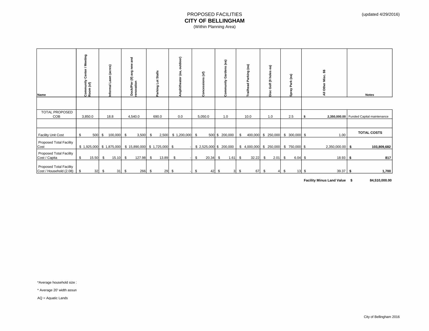
PROPOSED FACILITIES
CITY OF BELLINGHAM(Within Planning Area)
(updated 4/29/2016)
Name
TOTAL PROPOSED
COB
Facility Unit Cost
Proposed Total Facility
Cost
Proposed Total Facility
Cost / Capita
Proposed Total Facility
Cost / Household (2.08)
*Average household size 2015 = 2.08
* Average 20' width assumed, off-street system only.
AQ = Aquatic Lands
Co
mm
un
ity
Ce
nte
r / M
ee
tin
g
Ro
om
(s
f)
Info
rma
l L
aw
n (
ac
res
)
Do
ck
/Pie
r (l
f) a
vg
ne
w a
nd
ren
ov
ati
on
Pa
rkin
g L
ot
Sta
lls
Am
ph
ith
ea
ter
(ea
, o
utd
oo
r)
Co
nc
es
sio
ns
(s
f)
Co
mm
un
ity
Ga
rde
ns
(e
a)
Tra
ilh
ea
d P
ark
ing
(e
a)
Dis
c G
olf
(9
ho
les
ea
)
Sp
ray
Pa
rk (
ea
)
All O
the
r M
isc
. $
$
Notes
3,850.0 18.8 4,540.0 690.0 0.0 5,050.0 1.0 10.0 1.0 2.5 $ 2,350,000.00 Funded Capital maintenance
$ 500 $ 100,000 $ 3,500 $ 2,500 $ 1,200,000 $ 500 $ 200,000 $ 400,000 $ 250,000 $ 300,000 $ 1.00 TOTAL COSTS
$ 1,925,000 $ 1,875,000 $ 15,890,000 $ 1,725,000 $ - $ 2,525,000 $ 200,000 $ 4,000,000 $ 250,000 $ 750,000 $ 2,350,000.00 $ 103,809,682
$ 15.50 $ 15.10 $ 127.98 $ 13.89 $ - $ 20.34 $ 1.61 $ 32.22 $ 2.01 $ 6.04 $ 18.93 $ 817
$ 32 $ 31 $ 266 $ 29 $ - $ 42 $ 3 $ 67 $ 4 $ 13 $ 39.37 $ 1,700
Facility Minus Land Value $ 84,510,000.00
City of Bellingham 2016

D1
Appendix D N O R T H
B E L L I N G H A M
T R A I L P L A N
See the attached map and route descriptions.

D2
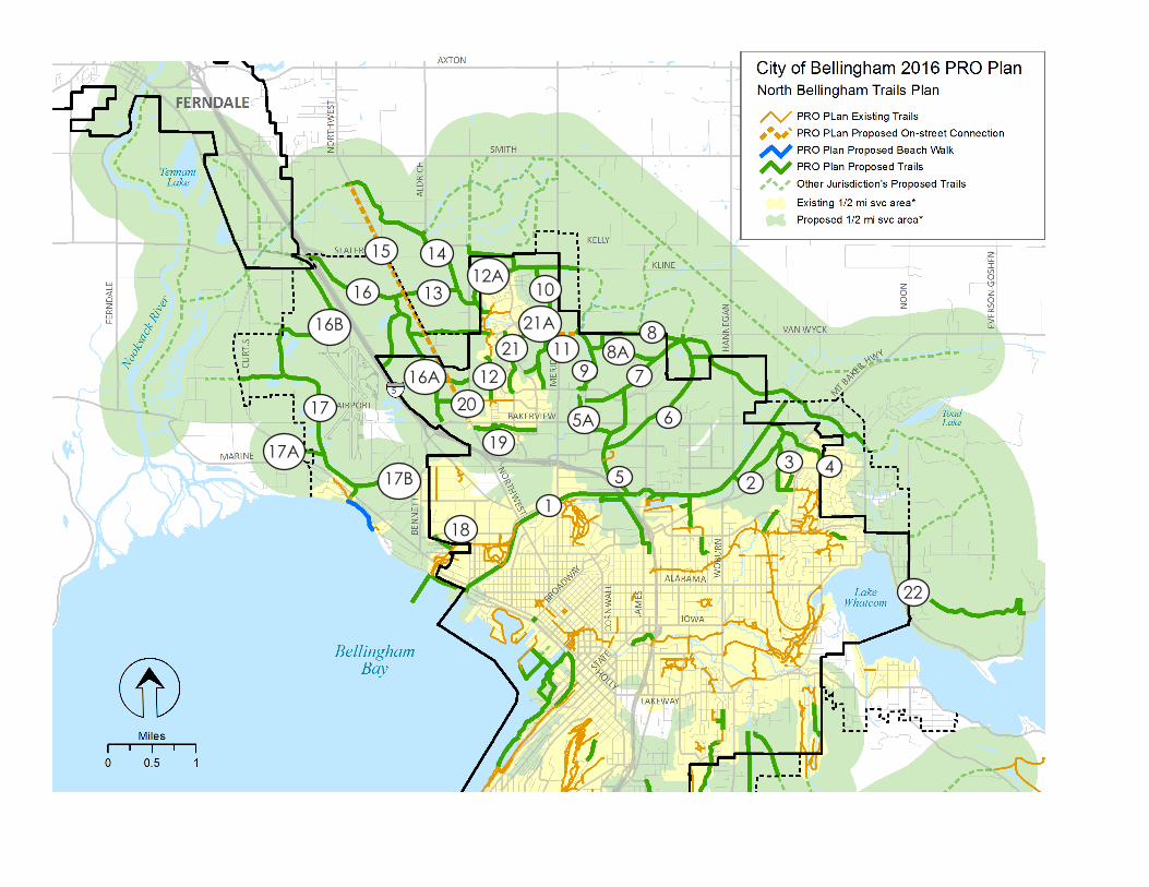
12
3 45
5A 6
7
88A
9
10
1112
12A13
1415
16
16A
16B
17
17A17B
18
19
20
2121A
22
North Bellingham Trail Route Descriptions
Map No. Trail Name Route Description Length
1 Bay to Baker Trail
Multi-purpose trail from Roeder Avenue to City Limits on railroad right of
way 5.18
2 Dewey Valley Loop
Loop trail off main Bay to Baker Trail through wooded hillside on DNR
property 0.87
3 Railroad Trail Connector
Connection from Railroad Trail to Bay to Baker Trail through subdivision
open space areas 1.03
4 Bay to Baker - Northridge Link
Multipurpose connector from Bay to Baker Trail (1) to northern Northridge
Park 1.44
5 Bay to Baker - King Mountain Link
Connector from bay to Baker Trail north to Kellogg Road and King
Mountain 1.42
5A Deemer Trail Neighborhood connector to Deemer Road 0.27
6 Queen Mountain Trail Connector from (Trail 5) to King Mountain Trail Hub 1.77
7 Spring Creek to King Mountain Trail Connector from Spring Creek Trail (10) to King Mountain Trail Hub 3.01
8 King Mountain East-West Trail
East-West Trail connecting Cordata Trails by way of Guide Meridian
Overpass (11), going over King Mountain to Bay to Baker Trail (1), and
eastward towards Squalicum Mountain 3.55
8A King Mountain Trail Trail from Van Wyck Park to Spring Creek 0.60
9 Spring Creek Trail From Bakerview north to North Bear Creek Trail (16) 1.35
10 Cordata East Trail
From Kellogg Rd. and WCC north to North Bear Creek Trail (16) at Klein
Road 1.71
11 Meridian Overpass Bike/Ped Overpass from Meridian av Van Wyk/Thomas Roads 0.10
12 West Cordata Trail
From Division Street Trail (27) north to North Bear Creek Trail (16) near
Aldrich Road, througoh proposed Aldrich Elementary School property 1.29
12A West Cordata Trail Link From Cordata Park through County property to Cordata Parkway 0.30
13 North Bear Creek Trail From Bear Creek Trail (16) east to Cordata East Trail (10) 1.00
14 Old Silver Creek Trail East-west connector from Cordata area west to NW Soccer Fields 2.02
15 Northwest Road Trail
Bike/Ped trail or sidewalks & bike lanes from I-5 north to Old Silver Creek
Trail (14) at NW Soccer Fields 3.03
16 Bear Creek Trail From Bakerview Road north to I-5 at Slater Road 2.75
16A Cordata to Bear Creek Trail From West Cordata Trail to Bear Creek Trail 0.50
16B Bear Creek to Coast Millennium Trail From Slater Road through north Airport property to Lost Lake area 1.72
17 Coast Millennium Trail
From Marine Drive south of Bellingham Airport north to the Bear Creek
Trail (16B) 1.82
17A West Extension of Coast Millennium Trail From Coast Millennium Trail (17) west to Wynn Road 0.36
17B East Extension of Coast Millennium Trail From Coast Millennium Trail (17) east to Alderwood School 0.61
18 Laurelwood Trail Extension south to Bay to Baker Trail (1) near Little Squalicum Park 0.26
19 Belleau Woods Trail From Northwest Road Trail (15) to Cordata Parkway/Bellis Fair Mall 0.74
20 Division Street Trail From Eliza Street west to Northwest Road Trail (15) 0.59
21 Cordata Pond Trail From Kellogg Road north to Horton Road 0.77
21A Cordata to Meridian Trail
Connector trail from Cordata Pond Trail (21) east to Meridian Overpass
(11) and on to King Mountain East-West Trail (8) 0.31
22 Bellingham to Mount Baker Trail From Cornwall Beach Park to the summit of Mt. Baker n/a
Total Trail Miles Proposed within Bellingham and UGA 40.37
E1
Appendix E C A P I TA L
FAC I L I T I E S
P L A N ( 6 Y E A R )
See the City's adopted 2015-2016 Parks and Recreation Department
6 year Capital Facilities Plan (CFP) on the following
pages. Expenditures for 2015-2016 were authorized after budget
adoption by the City Council. Expenditures identified for years
beyond 2016 are included for information and review of potential
future needs. Their inclusion is not a request for approval or budget
authorization.

E2
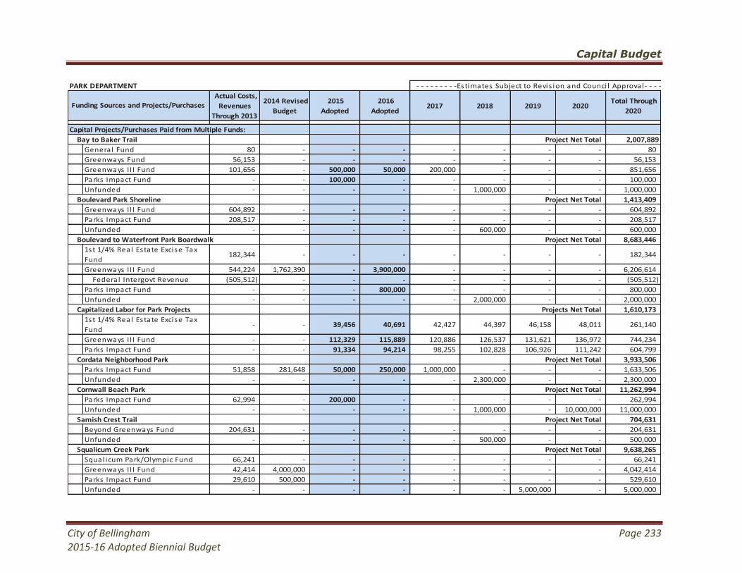
Capital Budget
City of Bellingham Page 233
2015-16 Adopted Biennial Budget
- - - - - - - - -Estimates Subject to Revis ion and Counci l Approval - - - - - - - - -
Actual Costs,
Revenues
Through 2013
2014 Revised
Budget
2015
Adopted
2016
Adopted 2017 2018 2019 2020
Total Through
2020
Capital Projects/Purchases Paid from Multiple Funds:
Bay to Baker Trail Project Net Total 2,007,889
General Fund 80 - - - - - - - 80
Greenways Fund 56,153 - - - - - - - 56,153
Greenways II I Fund 101,656 - 500,000 50,000 200,000 - - - 851,656
Parks Impact Fund - - 100,000 - - - - - 100,000
Unfunded - - - - - 1,000,000 - - 1,000,000
Boulevard Park Shoreline Project Net Total 1,413,409
Greenways II I Fund 604,892 - - - - - - - 604,892
Parks Impact Fund 208,517 - - - - - - - 208,517
Unfunded - - - - - 600,000 - - 600,000
Boulevard to Waterfront Park Boardwalk Project Net Total 8,683,446
1st 1/4% Real Estate Excise Tax
Fund182,344 - - - - - - - 182,344
Greenways II I Fund 544,224 1,762,390 - 3,900,000 - - - - 6,206,614
Federa l Intergovt Revenue (505,512) - - - - - - - (505,512)
Parks Impact Fund - - - 800,000 - - - - 800,000
Unfunded - - - - - 2,000,000 - - 2,000,000
Capitalized Labor for Park Projects Projects Net Total 1,610,173
1st 1/4% Real Estate Excise Tax
Fund- - 39,456 40,691 42,427 44,397 46,158 48,011 261,140
Greenways II I Fund - - 112,329 115,889 120,886 126,537 131,621 136,972 744,234
Parks Impact Fund - - 91,334 94,214 98,255 102,828 106,926 111,242 604,799
Cordata Neighborhood Park Project Net Total 3,933,506
Parks Impact Fund 51,858 281,648 50,000 250,000 1,000,000 - - - 1,633,506
Unfunded - - - - - 2,300,000 - - 2,300,000
Cornwall Beach Park Project Net Total 11,262,994
Parks Impact Fund 62,994 - 200,000 - - - - - 262,994
Unfunded - - - - - 1,000,000 - 10,000,000 11,000,000
Samish Crest Trail Project Net Total 704,631
Beyond Greenways Fund 204,631 - - - - - - - 204,631
Unfunded - - - - - 500,000 - - 500,000
Squalicum Creek Park Project Net Total 9,638,265
Squal icum Park/Olympic Fund 66,241 - - - - - - - 66,241
Greenways II I Fund 42,414 4,000,000 - - - - - - 4,042,414
Parks Impact Fund 29,610 500,000 - - - - - - 529,610
Unfunded - - - - - - 5,000,000 - 5,000,000
PARK DEPARTMENT
Funding Sources and Projects/Purchases

Capital Budget
Page 234 City of Bellingham
2015-16 Adopted Biennial Budget
- - - - - - - - -Estimates Subject to Revis ion and Counci l Approval - - - - - - - - -
Actual Costs,
Revenues
Through 2013
2014 Revised
Budget
2015
Adopted
2016
Adopted 2017 2018 2019 2020
Total Through
2020
Capital Projects/Purchases Paid from Multiple Funds (continued):
Waterfront Commercial Green Project Net Total 1,463,741
Parks Impact Fund 863,741 - - - - - - - 863,741
Unfunded - - - - - - 600,000 - 600,000
Whatcom Waterway Park Project Net Total 1,018,285
1st 1/4% Real Estate Excise Tax
Fund28,205 - - - - - - - 28,205
Federa l Intergovt Revenue (9,920) - - - - - - - (9,920)
Unfunded - - - - - 1,000,000 - - 1,000,000
Capital Projects/Purchases Paid from a Single Fund:
General Fund
Fleet Add 1/2 Ton Ful l Size Truck -- -- - - - 22,000 - - 22,000
Fleet Add 1/2 Ton Mid Size Truck -- -- - - - 19,000 - - 19,000
Fleet Add Beach Cleaning
Machine-- -- - - 13,000 - - - 13,000
Fleet Add One Ton Truck for
Transporting Large Area Mower -- -- - - 33,000 - - - 33,000
Fleet Add Power Rol ler -- -- - - 38,000 - - - 38,000
1st 1/4% Real Estate Excise Tax Fund
Annual Boundary Surveys - - 6,000 6,000 6,000 6,000 6,000 6,000 36,000
Annual Park Playground
Equipment Parts- 20,000 20,000 20,000 20,000 20,000 20,000 20,000 140,000
Annual Park Sign Replacement - - 15,000 15,000 15,000 15,000 15,000 15,000 90,000
Sidewalk and Curb Replacement - 25,000 25,000 25,000 25,000 25,000 25,000 25,000 175,000
Tra i l Surface/Drainage Repairs - 35,000 34,000 34,000 35,000 35,000 35,000 35,000 243,000
2nd 1/4% Real Estate Excise Tax Fund
Bloedel Dock Repairs - - 125,000 - - - - - 125,000
Cemetery Scatter Garden - - - 25,000 - - - - 25,000
Parks Faci l i ty Asphalt Patching
and Resurfacing- - 15,000 15,000 25,000 25,000 25,000 25,000 130,000
Playground Repairs and
Improvements- - - - 150,000 - - - 150,000
PARK DEPARTMENT - Continued
Funding Sources and Projects/Purchases
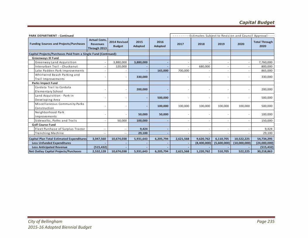
Capital Budget
City of Bellingham Page 235
2015-16 Adopted Biennial Budget
- - - - - - - - -Estimates Subject to Revis ion and Counci l Approval - - - - - - - - -
Actual Costs,
Revenues
Through 2013
2014 Revised
Budget
2015
Adopted
2016
Adopted 2017 2018 2019 2020
Total Through
2020
Capital Projects/Purchases Paid from a Single Fund (Continued):
Greenways III Fund
Greenway Land Acquis i tion - 3,880,000 3,880,000 - - - - - 7,760,000
Interurban Tra i l - Chuckanut - 120,000 - - - 680,000 - - 800,000
Lake Padden Park Improvements - - - 165,000 700,000 - - - 865,000
Whirlwind Beach Parking and
Tra i l Improvements- - 330,000 - - - - - 330,000
Parks Impact Fund
Cordata Tra i l to Cordata
Elementary School- - 200,000 - - - - - 200,000
Land Acquis i tion - Park in
Developing Area- - - 500,000 - - - - 500,000
Miscel laneous Community Parks
Construction- - - 100,000 100,000 100,000 100,000 100,000 500,000
Neighborhood Park
Improvements- - 50,000 50,000 - - - - 100,000
Sidewalks , Paths and Tra i l s - 50,000 100,000 - - - - - 150,000
Golf Course Fund
Fleet Purchase of Surplus Tractor -- -- 9,424 - - - - - 9,424
Trenching Machine -- -- 29,100 - - - - - 29,100
Capital Plan Total Estimated Expenditures 3,047,560 10,674,038 5,931,643 6,205,794 2,621,568 9,620,762 6,110,705 10,522,225 54,734,295
Less Unfunded Expenditures - - - - - (8,400,000) (5,600,000) (10,000,000) (24,000,000)
Less Anticipated Revenue (515,432) - - - - - - - (515,432)
2,532,128 10,674,038 5,931,643 6,205,794 2,621,568 1,220,762 510,705 522,225 30,218,863
PARK DEPARTMENT - Continued
Funding Sources and Projects/Purchases
Net Outlay Capital Projects/Purchases

F1
Appendix F R E V E N U E
S O U RC E
D E S C R I P T I O N S
The following is a general description of the different types of revenue sources that may be used to fund park, recreation and open space programs or facilities. Some are restricted to development only while others may be used for operations and maintenance. These are listed in no particular order and with no reference to the feasibility or recommendation of implementing each revenue source. General Fund
The General Fund is derived from property taxes, licenses and permits, intergovernmental revenues including state and federal grants, service charges and fees, fines and forfeitures, and other miscellaneous revenues. General funds are used to finance most government operations including staff, equipment, capital facility and other requirements. Park, recreation and open space programs and operations are funded primarily from general fund accounts.
• Sales Tax - is the City's largest single revenue source and may be used for any legitimate City purpose. The City has no direct control over this source; it is collected and distributed by the State and may fluctuate with general economic and local business conditions.
• Property Tax - under Washington State's constitution, cities may levy a property tax rate not to exceed $3.60 per $1,000 of the assessed value of all taxable property within incorporation limits. The total of all property taxes for all taxing authorities, however, cannot exceed 1.0% of assessed valuation, or $10.00 per $1,000 of value. If the taxes of all districts exceed the 1.0% of $10.00 amount, each is proportionately reduced until the total is at or below the 1.0% limit.
In 2001, Washington State law was amended by Proposition 747, a statutory provision limiting the growth of regular property taxes to 1.0% per year, after adjustments for new construction. Any proposed increases over this amount are subject to a referendum vote. The statute was intended to control local governmental spending by controlling the annual rate of growth of property taxes. In practice, however, the statute can reduce the effective property tax yield to an annual level far below a city's levy authorization, particularly when property values are increasing rapidly.
Special Revenues
Special revenues are derived from state and local option taxes
dedicated to specific expenditure purposes, such as the motor vehicle
F2
tax, motor excise tax, real estate excise tax, motel and hotel tax, public art, criminal justice, paths and trails,
convention center and the like. Some special revenues may be used to finance limited capital facilities, such
as roads or parks, where the local option allows - such as the local real estate excise tax (REET).
Debt Service Funds
Debt service funds are derived from a dedicated portion of the property tax or general fund proceeds to
repay the sale of general obligation (voted) and Councilmanic (non-voted) bonds. Both types of bonds may
be used to finance park facility improvements - but not maintenance or operational costs.
• Councilmanic (limited or non-voted) bonds - may be issued without voter approval by the Council for any
facility development purpose. The total amount of all outstanding non-voted general obligation debt may
not exceed 1.5% of the assessed valuation of all city property.
Limited general obligation bonds must be paid from general governmental revenues. Therefore, debt
service on these bonds may reduce the amount of revenue available for current operating expenditures
and the financial flexibility of the Council may need to fund annual budget priorities. For this reason,
Councilmanic bonds are usually only used for the most pressing capital improvement issues. This method
was used to fund the 2006 improvements at Civic Athletic Complex.
• Unlimited general obligation bonds - must be approved by at least 60% of resident voters during an
election which has a turnout of at least 40% of those who voted in the last state general election. The
bond may be repaid from a special levy, which is not governed by the 1.0% statutory limitation on the
property tax growth rate. Total indebtedness as a percent of the assessed valuation that may be
incurred by limited and unlimited general obligation bonds together, however, may not exceed:
2.5% - provided that indebtedness in excess of 1.5% is for general purposes,
5.0% - provided that indebtedness in excess of 2.5% is for utilities, and
7.5% - provided that indebtedness in excess of 5.0% is for parks and open space development.
Monies authorized by limited and unlimited types of bonds must be spent within 3 years of authorization
to avoid arbitrage requirements unless invested at less than bond yield. In addition, bonds may be used
to construction but not maintain or operate facilities. Facility maintenance and operation costs must be
paid from general governmental revenue or by voter authorization of special annual or biannual
operating levies or by user fees or charges.
Enterprise Funds
Enterprise funds are derived from the user fees and charges levied for utility operations including water and
sewer, storm drainage, regional water, solid waste and cemetery. The enterprise revenues are used to pay
operating costs, retire capital facility debt and plan future replacement and expansion projects. Enterprise
funds may be created for a park or recreation activity that has a revenue source sufficient to finance all costs.
Enterprise funds have been used on a limited basis for golf courses, marinas and similar self-financing
operations.
F3
Special Legislation
Local government representatives can seek state enabling legislation authorizing new or special revenue
sources. Senate Bill 5972 (RCW 82.46) is an example of one possible legislative solution. The 1982 bill
gave city governments the option of adding an additional 0.0025% increment to the real estate excise tax
(REET) for the sole purpose of financing local capital improvement projects including parks, utilities and other
infrastructure except governmental buildings.
Like bonds, Senate Bill 5972 funds may not be used to finance operation and maintenance requirements.
Unlimited General Obligation Bonds
Bellingham may come to depend on voter referendums as a means of financing a larger portion of the capital
improvement program, since unlimited obligation bonds are not paid from the property tax subject to the
1.0% limitation.
Voter approved capital improvements may be more representative of actual resident priorities than some
other methods of validating capital expenditures, and will at the least, ensure referendum submittals provide
widespread benefits. However, bond revenue cannot be spent for maintenance and operational issues - and
bond referendums must be approved by a margin over 60% of the registered voters who participated in the
last election.
General Levy Rate Referendums
Proposition 747, the statutory provision limiting the growth of regular property taxes to 1.0% per year, can
be waived by referendum approval of a simple (50%) majority of Bellingham's registered voters. Voters can
be asked to approve a resetting of the property tax levy rate that would adjust the amount of revenue the
city can generate. The new total revenue that can be generated by a resetting of the rate would be subject
to the same 1.0% limitation, however, and the total amount of revenue and the resulting property tax rate
would start to decline again in accordance with the Proposition.
However, the adjusted rate and revenue could finance specific capital improvement projects - or programs
that involve construction, maintenance and operations aspects that a majority of the voters are willing to pay
for under the adjusted rate.
The resetting of the rate can be permanent, subject to the provisions of Proposition 747. Or temporary,
where the rate is adjusted until a specific amount of revenue has been generated to finance a project or
program - whereupon the rate reverts to the original or a specified amount defined in the referendum.
Bellingham voters have passed three levy rate referendums, to the fund the Greenway Program acquisitions,
improvements and maintenance endowment. The current levy will expire in 2016.
Environmental Impact Mitigation - Subdivision Regulations
City subdivision policies require developers of subdivisions within the City, or on lands that may eventually
annex to the City, to provide suitably designed and located open spaces, woodland preserves, trail systems,
playgrounds and other park or recreational facilities. Such facilities may include major components of the
park or recreational system that may be affected by the project's location or development. The City may
F4
also consider requiring developers to provide acceptable long-term methods of managing and financing
maintenance requirements. Attractive management systems could include:
• Ownership by a private organization - like a tennis, swimming or golf club, who assumes responsibility for
all maintenance responsibilities and costs,
• Ownership by a homeowners or common property owners association - who may contract maintenance
responsibilities and assess property owner's annual costs.
• Dedication of property - to an adjacent city or school district who assumes maintenance responsibilities
using local city or school funds, or
• Creation of a special recreation service district - where locally elected district representatives manage
maintenance requirements and select a local method of financing.
The City should not accept title and maintenance responsibilities unless the land or facility will be a legitimate
community park or recreation element that may be supported using public financing. The City may be
contracted by any of the other agencies to provide or oversee a maintenance contract on the owner's behalf
provided all City costs are reimbursed by an approved method of local financing.
Growth Impact Fees
Bellingham has adopted a growth impact fee provision in accordance with the Washington State Growth
Management Act (GMA). A park impact fee is applied to all proposed residential developments within the
city as a means to maintaining park, recreation and open space levels-of-service. The ordinance makes
provisions for setting aside the resources, including lands or monies, necessary to offset the impact new
residential development project has on park, recreation and open space facilities.
Land contributions can be accepted in lieu of impact fees if they will be suitable sites for future facilities.
Land and fees accumulated under the ordinance must be invested within a reasonable time of impact
assessment or be returned to the contributing developer.
Inter-local Agreements
Bellingham could work with Whatcom County to determine an equitable means whereby growth mitigation
park impact fees can be collected for residential developments occurring within the urban growth area
outside of existing city limits, but within the area the city eventually expects to annex.
A joint growth impact fee should be collected where the county and city maintain the same local and regional
or citywide level-of-service (LOS) presently existing within the incorporated (city) and unincorporated (county)
sections, and for the urban growth area in total. A common fee could be collected by each agency, then
shared on a project by project basis for improvements benefitting local neighborhoods (and potential
residents of proposed subdivisions) or residents of the community and urban growth area-at-large.
The City should also work with the Bellingham School District to determine to what extent the City could
cooperatively finance shared or common facility improvements. Such improvements could use co-located
school and park sites, commonly improved and scheduled fields and facilities, and the sharing of park and
school growth impact fees - among other options.
F5
It is to Bellingham's advantage to assist the school district with the development and operation of common
facilities since these facilities serve residents of the entire city.
In return, however, the city and school district must determine some equitable means whereby the city and
school district perform or reimburse each other for some of the added facility maintenance and operational
impacts that users create on each agency's facilities.
User Fees and Charges
The City may increase the number of activities subject to user fees and charges and use the proceeds to
purchase land, develop, operate and maintain facilities where all costs are reimbursed by the revenue
obtained. Essentially, the City has become a facility developer/operator providing whatever facilities or
services the market will support from user revenue.
User fees have been and could be used to provide facilities for park and recreation activities whose profit
margins are too low to sustain commercial operations or whose benefiting user group may extend beyond
county boundaries. Possible user fee financed facilities include indoor tennis and racquetball facilities, golf
courses, horse stables and equestrian centers, boating resorts, recreational vehicle parks and any other facility
where demand is sizable enough to warrant a user fee financing approach.
In essence, the market determines which facility's revenues equal costs, and thereby, which programs the City
would provide on a direct costs/benefit basis. To date, City user fee revenues provide a significant source of
operating funds for recreational programs. While important, this source of finance will likely never pay full
costs for all programs, or any operation, maintenance or development costs.
Special Funding Sources
Bellingham has approved or could submit for approval the following special financing options.
• REET (Real Estate Excise Tax) - RCW 82.46 gives city governments the option of adding up to two
0.0025% increments to the real estate excise tax (REET) for the sole purpose of financing local capital
improvement projects. REET funds may not be used to finance operation and maintenance requirements.
Bellingham has adopted both REET options.
REET remains a viable financing tool for park, recreation and open space acquisition and development
projects. However, REET funds are to be used for all city capital requirements, not just park purposes.
• Greenway Funds - in 1990, 1997 and 2006, Bellingham voters approved property tax levies to fund the
acquisition and development of park, recreation and open space projects. The most recent levy, which
represented an annual cost of $57.00 per $100,000 in property value, will expire in the year 2016. The
three levies combined will generate a total of $71 million in funding.
F6
State Grants
Washington State funds and administers a number of programs for non-motorized transportation and trails
purposes using special state revenue programs.
• Washington Wildlife Recreation Program (WWRP) - provides funds for the acquisition and development
of conservation and recreation lands. The Habitat Conservation Account of the WWRP program provides
funds to acquire critical habitat, natural areas and wildlife categories. The Outdoor Recreation Account
of the WWRP program provides funds for local parks, state parks, trails and water access categories.
• Aquatic Lands Enhancement Act (ALEA) - uses revenues obtained by the Washington Department of
Natural Resources from the lease of state owned tidal lands. The ALEA program is administered by the
IAC for the development of shoreline related trail improvements and may be applied for up to 50% of
the proposal.
• Endangered Species Act (ESA) - a Department of Ecology administered water quality program provides
grants for up to 75% of the cost of water quality/fish enhancement studies. Referendum 39 monies can
be applied to park developments that propose to restore, construct or otherwise enhance fish producing
streams, ponds or other water bodies.
• Capital Projects Fund for Washington Heritage - provides funds for the restoration and renovation projects
for historical sites and buildings by local governments and nonprofit agencies. The program is
administered by the Heritage Resource Center (HRC).
• Boating Facilities Program - approved in 1964 under the state Marine Recreation Land Act, the program
earmarks motor vehicle fuel taxes paid by watercraft for boating-related lands and facilities. Program
funds may be used for fresh or saltwater launch ramps, transient moorage and upland support facilities.
• Washington State Public Works Commission - initiated a program that may be used for watercraft
sanitary pump-out facilities.
• Youth Athletic Facilities (YAF) - provides grants to cities, counties and qualified nonprofit organizations for
the improvement and maintenance of existing, and the development of new athletic facilities.
• Non-Highway & Off-Road Vehicle Activities Program (NOVA) - provides funding to develop and manage
recreation opportunities for users of off-road vehicles and non-highway roads. An allocation (1%) from
the state Motor Vehicle Fuel Tax (MVFT) and off-road vehicle (ORV) permit fees fund the program.
NOVA funds may be used for the planning, acquisition, development, maintenance and operation of off-
road vehicle and non-highway road recreation opportunities.
• Firearms and Archery Range Recreation Program (FARR) - provides funds to acquire, develop and renovate
public and private nonprofit firearm and archery training, practice and recreation facilities. The program
is funded from a portion of the fees charged for concealed weapons permits.
F7
Federal Grants
Federal monies are available for the construction of outdoor park facilities from the National Park Service
(NPS) Land and Water Conservation Fund (LWCF). The Washington State Interagency Committee for
Outdoor Recreation (IAC) administers the grants.
• National Park Service (NPS) grants - usually do not exceed $150,000 per project and must be matched
on an equal basis by the local jurisdiction. The IAC assigns each project application a priority on a
competitive statewide basis according to each jurisdiction's need, population benefit, natural resource
enhancements and a number of other factors. In the past few years, project awards have been extremely
competitive as the federal government significantly reduced the amount of federal monies available to
the NPS program. The state increased contributions to the program over the last few years using a
variety of special funds, but the overall program could be severely affected by pending federal deficit
cutting legislation.
Applicants must submit a detailed comprehensive park, recreation and open space plan to be eligible for
NPS funding. The jurisdiction's plan must demonstrate facility need, and prove that the jurisdiction's
project proposal will adequately satisfy local park, recreation and open space needs and interests. Due
to diminished funding, however, IAC grants have not been a significant source of project monies for city or
other local jurisdictions in recent years.
• Transportation Enhancement Grants - can be used to finance on and off-road non-motorized trail
enhancements along major and minor arterial collectors roads or sometimes, within separate trail
corridors. The program was adopted in 1993 and is administered by the Regional Transportation
Organization on behalf of the US Department of Transportation.
Applicants must demonstrate the proposed trail improvements will increase access to non-motorized
recreational and commuter transportation alternatives.
• National Recreational Trails Program (NRTP) - is the successor to the National Recreational Trails Act
(NRFTA). Funds may be used to rehabilitate and maintain recreational trails that provide a backcountry
experience. In some cases, the funds may be used to create new "linking" trails, trail relocations and
educational programs.
• Boating Infrastructure Grant Program (BIG) - supports development and renovation of areas for non-
trailer-able recreational boats over 26 feet and related support elements on US navigable waters. Funds
may be used to produce and distribute information and educational materials. The federal program
compliments the state-funded Boating Facilities Program (BFP) administered for smaller vessels.
Recreation Service Districts (RCW Chapter 36.69)
State legislation authorizes the establishment of recreation service districts as special units of government that
may be wholly independent of any involvement with a county or any other local public agency or jurisdiction.
Districts may provide recreational facilities that are specific to the district's boundaries in return for the district
residents' agreement to pay the special development, operation and maintenance costs utilizing special
financing devices.
F8
Special recreation service districts must be initiated by local jurisdiction resolution or citizen petition following
hearings on feasibility and costs studies of the proposed district's facility development or operation costs. The
proposal must ultimately be submitted for voter approval including all provisions relating to any special
financing agreements. The voters must initially approve the formation of the district and may designate
existing elected officials, or a body appointed by existing elected officials, or elect district commissioners or
officers solely responsible for park and recreation policy. Separate voter approvals must be sought for 3-
year operating levies providing maintenance, repair, operating costs and facility acquisition and development
projects.
A recreation service district can be flexible and used to provide local recreational facilities in the same
variety of custom service choices with the exception that the governing board may be separately elected.
There are no limitations on the number of separate recreation service districts that can be established within a
county, provided no district overlaps another.
Metropolitan Park Districts (SB 2557)
In 2002, the state legislature authorized the establishment of metropolitan park districts as special units of
government that may be wholly independent of any involvement with a city, county or any other local public
agency or jurisdiction. Like recreation service districts, metropolitan park districts may provide recreational
facilities that are specific to the district's boundaries in return for the district residents' agreement to pay the
special development, operation and maintenance costs utilizing special financing devices.
Metropolitan park districts must be initiated by local government resolution or citizen petition following
hearings on feasibility and costs studies of the proposed district's facility development or operation costs. The
proposal must ultimately be submitted for voter approval (50%) including all provisions relating to any
special financing agreements. The voters must initially approve the formation of the district, and may
designate existing elected officials, or a body appointed by existing elected officials or elect district
commissioners or officers solely responsible for park and recreation policy.
Unlike recreation service districts, voters must also approve the establishment of a continuous levy as a junior
taxing district - compared with 3 year levies under a recreation service district to provide maintenance, repair,
operating costs and facility acquisition and development projects.
Like the recreation service district, a metropolitan park district can be flexible and used to provide local
recreational facilities in the same variety of custom service choices with the exception that the financing levy
may be as a junior taxing district with a continuous levy.
There are no limitations on the number of separate recreation service districts that can be established within a
city, county or as a combination of multiple cities and counties provided no district overlaps another.
The Tacoma Metropolitan Park District was established in 1909 and is the largest and oldest recreation park
district in the State of Washington. The Chuckanut Community Forest Park District was established in 2013 for
the specific purpose of raising funds to pay back the loan used to acquire the Fairhaven Highlands
development property.
F9
Special Use Agreements
Special property agreements can often be used instead of property purchases to secure public use rights for
land or property at no cost or a nominal fee, particularly where the possible public use is of benefit to the
private landowner. Some forms of special use agreements can provide favorable tax benefits if the use
agreement can be shown to have an assigned value.
The City could expand the use agreement concept to include complete development, operation or
maintenance responsibilities. Package lease agreements will usually provide more effectively maintained
facilities than possible where the City must staff specialized, small work crews.
Sometimes package lease agreements covering use and maintenance aspects may be the only way of
resolving an equitable agreement with the private ownership. This may include trails on utility corridors where
the ownership may prefer to control development and maintenance activities, and the City may prefer to
avoid any implied responsibility or liability for the utility worthiness which the City's maintenance of a trail
system could imply.
Public/Private Service Contracts
Private market skills and capital may be employed in a variety of ways including the use of public/private
services contracts where a private party can be contracted to operate and maintain a facility for a fixed fee
cost. Service contracts can be very efficient where the activities are small, scattered in location, seasonal,
expert or experimental. Service contracts are also relatively easy to initiate or terminate of area demand
fails to provide sufficient use or revenue to justify continued operation.
Service contracts may be very flexible and can include agreements with city, school district or local user
groups who can or would be interested in sustaining the activity on a subsidized or sweat-equity basis on
exchange for the facility.
Public/Private Concessions
The City could lease a portion of a site or facility to a private party in exchange for a fixed fee or a
percentage of gross receipts. The private operator assumes operation and maintenance responsibilities and
costs in exchange for a profit. For certain types of facilities, such as enterprise fund account facilities like golf
courses, the City's portion of the profits may be used to pay facility development and/or operation and
maintenance costs at the same or for similar facility developments.
The City may save considerable monies on concessions where the activities are specialized, seasonal,
experimental or unproven. Concessions can be easily initiated, provide direct user benefit/cost
reimbursements and relieve the City of a capital risk should market or user interest fail to materialize to at
least break-even levels.
Concessionaires could operate a wide variety of park and recreational facilities including horse stables and
equestrian centers, boating and bicycle rentals, special group and recreational vehicle compounds, athletic
field and court facilities, swimming pools and beaches, shooting ranges and ORV tracks among others.

F10
Public/Private Joint Development Ventures
The City can enter into an agreement with a private or public developer to jointly own or lease land for an
extended period of time. The purpose of the venture would be to allow the development, operation and
maintenance of a major recreational facility or activity in exchange for a fixed lease cost or a percentage of
gross receipts.
The developer assumes development, operation and maintenance responsibilities, costs and all market risks in
exchange for a market opportunity providing a profitable return not otherwise available. The City realizes
the development of a facility in exchange for a low minimum capital return and no or very little capital risk.
Joint development agreements represent an ultimate benefit/cost resolution that may also provide public
revenue that the City could use for other development opportunities. Examples include the possible joint
development on City lands of equestrian centers, marinas, hostels, recreational vehicle campgrounds, seminar
retreats, special resorts, indoor racquetball courts and athletic clubs, swimming pools and water parks, golf
courses, gun and archery ranges and ORV competition tracts, among others.
Self-Help Land Leases
There are instances where an activity is so specialized in appeal or of a service area so broad in scope that it
cannot be equitably financed using general public funds. Specialized user groups should be provided options
for developing or maintaining facilities in ways that account for equitable public cost reimbursements.
Examples include the use of land leases where the City may lease land at low or no cost where a user group
or club assumes responsibility for the development, operation and maintenance of the facility. The club could
provide volunteer help or use club finances to develop, operate and maintain the facility as a means of
meeting user benefit/cost objectives.
Land lease agreements could accommodate organized athletics like soccer, baseball, football, softball and
rugby; or very specialized facilities like shooting ranges, archery fields, ORV trails and ultra-light aircraft
parks, among others.
Self-Help Contract Agreements
The City can purchase land, develop, operate and maintain a specialized facility under a negotiated contract
agreement where a special interest group agrees to defray all costs in addition to or in lieu of a user fee as
a means of meeting user benefit/cost objectives. The agreements can be quite flexible and could contract the
City, the user group, another public agency or a private operator to be developer/operator.
Contract agreements could accommodate a range of more expensive special purpose facility developments
including high quality athletic competition facilities for league organizations and specialized facility
developments like shooting ranges and ORV tracks when and where the user organization can provide
financial commitments.