recreation management plan
TRANSCRIPT

New York State Department of Environmental Conservation
DIVISION OF LANDS & FORESTS
UPPER HUDSON WOODLANDS ATP CONSERVATION EASEMENT
RECREATION MANAGEMENT PLAN FOR
FISHING, BOATING AND HUNTING ACCESS
BLOCK: HIGH PEAKS TRACTS: BLUE RIDGE ROAD, TOWNSHIP 19 & TOWNSHIP 20
BLOCK: INDIAN LAKE
TRACT: TOWNSHIP 33
BLOCK: LAKE GEORGE TRACT: SOMERVILLE ROAD
BLOCK: GREAT SACANDAGA LAKE TRACT: LAKE DESOLATION ROAD
COUNTIES OF: WARREN, SARATOGA, ESSEX AND HAMILTON TOWNS OF: INDIAN LAKE, LONG LAKE, GREENFIELD, LAKE GEORGE, NORTH CREEK, NORTH HUDSON AND WARRENSBURG
OCTOBER 2014
Andrew M. Cuomo, Governor Joe Martens, Commissioner
For further information contact: Allison Buckley NYS DEC Northville Office 701 South Main Street Northville, NY 12134

Table of Contents PREFACE .................................................................................................................................... 1
Use of Conservation Easements ................................................................................................................ 1
I. INTRODUCTION ................................................................................................................... 2 A. Purpose of the Recreation Management Plan .................................................................................. 2
B. Geographic Information .................................................................................................................... 4
II. NATURAL AND CULTURAL RESOURCES ............................................................................ 4A. Physical Resources ............................................................................................................................. 4
1. Terrain/Topography .......................................................................................................................... 4
2. Geology and Soils ......................................................................................................... 4
3. Water and Wetlands .................................................................................................... 4
B. Biological Resources .......................................................................................................................... 5
1. Fish and Wildlife ........................................................................................................... 5
2. Endangered, Threatened and Species of Special Concern ............................................. 6
3. Natural Heritage Program Elements of Occurrence ....................................................... 7
4. Invasive Species ............................................................................................................ 7
C. Cultural Resources ............................................................................................................................. 8
1. Cultural and Archaeological ......................................................................................... 8
2. Wild, Scenic and Recreational Rivers ............................................................................ 8
D. Economic Impact ............................................................................................................................... 8
III. LANDOWNER MANAGEMENT AND USE ............................................................................ 9A. Property History ................................................................................................................................ 9
B. Current Forestry Uses ........................................................................................................................ 9
C. Current Non-Forestry Uses of the Property ...................................................................................... 9
1. Recreational Leases ..................................................................................................... 9
D. Property Infrastructure ................................................................................................................... 10
1. Existing Infrastructure ................................................................................................. 10
2. Gravel Pits ................................................................................................................... 10
IV. RELATIONSHIP OF PROPERTY TO ADJACENT LANDS ....................................................... 10A. Public Property ................................................................................................................................ 10
1. Forest Preserve Lands ................................................................................................. 10
2. Other State Owned Property ....................................................................................... 11
B. Private Property ............................................................................................................................... 11
Upper Hudson Woodlands ATP Fishing, Boating and Hunting Draft Recreation Management Plan
October 2014
I

V. PUBLIC USE ADMINISTRATION AND MANAGEMENT ........................................................ 11 A. Laws, Policies and Memoranda ....................................................................................................... 11
B. Regulatory Requirements, Approvals and Procedures ................................................................... 12
C. Guidelines and Standards ................................................................................................................ 13
D. Management Authority, Staff and Responsibility ........................................................................... 14
E. Public Recreation Management Principals, Goals and Objectives .................................................. 15
1. Management Principles .............................................................................................. 15
2. Management Goals and Objectives ............................................................................. 15
3. Best Management Practices ........................................................................................ 16
VI. CONSERVATION EASEMENT AFFIRMATIVE RIGHTS .......................................................... 16A. Recreation Access and Use Rights ................................................................................................... 17
1. Public Recreational Amenities and Improvements ...................................................... 17
2. Non-motorized Access - Use and Activities .................................................................. 18
3. Motorized Access - Use and Activities ......................................................................... 18
4. Public Fishing Corridors ............................................................................................... 18
5. Public Recreational Use Areas (PUAs).......................................................................... 18
B. Other Conservation Easement Provisions Affecting Public Use ...................................................... 19
1. Barriers, Gates, and Locks ........................................................................................... 19
2. Parking Areas .............................................................................................................. 19
3. Campsites ................................................................................................................... 19
4. Search, Rescue, Fire, Emergency Response, and Law Enforcement ............................. 19
VII. PROPOSED RECREATION MANAGEMENT ACTIONS AND IMPLEMENTATION ................ 20A. General Recreation Management Actions ...................................................................................... 20
1. Location of Boundaries ...............................................................................................20
2. Signs ...........................................................................................................................20
3. Logging Closure Zones .................................................................................................20
4. Shared Road Maintenance ..........................................................................................20
5. Monitoring .................................................................................................................. 21
B. Specific Recreational Activities ........................................................................................................ 22
1. Blue Ridge Road Tract (High Peaks Block) ....................................................................22
2. Township 19 Tract (High Peaks Block) ........................................................................ 24
3. Township 20 Tract (High Peaks Block) ......................................................................... 25
4. Township 33 (Indian Lake Block) ................................................................................. 30
5. Somerville Road Tract (Lake George Block) ................................................................. 32
Upper Hudson Woodlands ATP Fishing, Boating and Hunting Draft Recreation Management Plan
October 2014
II

6. Lake Desolation Road Tract (Sacandaga Block) ............................................................ 33
VIII. COMPLIANCE ................................................................................................................. 35A. October 2011 - Conservation Easement Recreation Management Plan Guidance ........................ 35
B. State Environmental Quality Review Act ......................................................................................... 35
C. Freshwater Wetlands Act ................................................................................................................ 36
D. APA/DEC MOU Concerning State Owned Conservation Easements on Private Lands within the Adirondack Park............................................................................................................................... 36
IX. IMPLEMENTATION SCHEDULE ........................................................................................... 37A. Schedule and Budget ....................................................................................................................... 37
X. APPENDCIES ........................................................................................................................ 39 A. Definitions used within the RMP as defined by the Conservation Easement ................................. 39
B. Public Comment and Response Summary to Draft RMP ............................................................... 41
C. SEQR Negative Declaration.............................................................................................................. 42
Upper Hudson Woodlands ATP Fishing, Boating and Hunting Draft Recreation Management Plan
October 2014
III

Upper Hudson Woodlands ATP Fishing, Boating and Hunting Draft Recreation Management Plan
October 2014
IV

PREFACE
Use of Conservation Easements
The New York State Legislature has declared that the public policy of the State is to conserve, preserve, and protect its environmental assets and natural and man-made resources. In addition to purchasing lands on behalf of the People of the State, the State also protects land and natural resources by acquiring less than full interests in land, using a permanent legal agreement called a conservation easement. Conservation easements are used widely across the United States by government and non-profit land conservation organizations to protect a variety of properties with important natural resources and other landscape values such as water quality, wildlife habitat, sensitive ecosystems, wetlands, riparian areas, scenic areas such as meadows and ridgelines, agricultural land, working forests, and historic sites. The primary function of easements is to limit or eliminate future development and undesirable land uses on a property, while allowing for continued private ownership and traditional management. Some conservation easements allow public access to the protected property and some do not.
New York State acquires conservation easements primarily on properties that buffer existing State lands, provide additional public recreational opportunities, and/or maintain large working forests. There are now hundreds of thousands of acres of land in New York that are protected by conservation easements acquired by the State. Most of that land consists of large tracts of commercial timber land in the Adirondack and Tug Hill regions; however DEC also holds easements on a variety of other properties across the State.
On many large working forest conservation easement properties, the State has acquired some level of public recreation rights in addition to development and land use restrictions. In some cases, a wide range of public recreational use is permitted, and in others public access is very limited. The amount of public access depends largely on the goals and objectives of the landowner and the State at the time the easement was negotiated. All of these lands are actively managed for forest products, and many of the companies who own the land also rely on income from private hunting and fishing club leases.
This recreation management plan will explain the combination of public recreational rights the State acquired through the conservation easement and how these rights are to be implemented on the property in a compatible way with the rights retained by the landowner.
Upper Hudson Woodlands ATP Fishing, Boating and Hunting Access Recreation Management Plan
October 2014
1

I. INTRODUCTION On June 18, 2007, The Nature Conservancy (TNC), acquired approximately 161,000 acres of forestland from Finch, Pruyn and Company, located in the central and south eastern portions of the Adirondack Park in northeastern New York State. TNC sold the 92,035 acre “Upper Hudson Woodlands” Property to Upper Hudson Woodlands ATP, LP on March 27, 2009. In addition, TNC sold specific conservation and recreation easement (“Easement”) rights on these forestlands to the State of New York on December 27, 2010. The Easement will assure that the property will remain as a sustainable working forest, protect natural resources, continue private recreational leases and allow for new public recreation opportunities. The Easement grants New York State a legal interest in the property and sets forth terms, restrictions and rights of both the landowner and the State with respect to use and management of the tract. The State now holds the development rights on the property, and in some cases, specified recreation rights. As with prior conservation easements, the State, through its ownership of the development rights, effectively extinguishes those development rights on the property in perpetuity. The landowner is responsible for managing the Upper Hudson Woodlands Property in a manner that protects water quality, maintains and enhances biological diversity, provides for a broad distribution of forest age classes and provides standing dead trees, den and nest trees and large downed trees. The New York State Department of Environmental (Department or NYSDEC) is responsible for managing the rights obtained by the People of New York and ensuring the landowner is managing the property as required by the Easement. This Recreation Management Plan applies to those lands subject to the Conservation Easement held by the State within Essex, Hamilton, Warren and Saratoga Counties, in the Towns of Long Lake, Indian Lake, North Creek, North Hudson, Greenfield, Lake George and Warrensburg, referred to herein as the “Protected Property” or “Property”. More specifically, this document will address the Fishing, Boating and Public Use Areas in the Upper Hudson Woodlands ATP Easement. This Conservation Easement was filed in the counties listed above.
A. Purpose of the Recreation Management Plan The Upper Hudson Woodlands ATP Conservation Easement grants the State of New York specific legal interests in the Easement Property, including a guaranteed right to permit public access, with limitations, for certain natural resource-based outdoor recreation activities. Public recreation access to privately-owned conservation easement lands is guided by a Recreation Management Plan (RMP) that is developed for each easement property. Preparation of this RMP is required in accordance with some Conservation Easements. It is the position of the Department to provide a copy of this RMP to the property owner (“the Landowner”) for review even if the Easement may not require the Department to do so. This RMP addresses the State’s role in planning, implementing, and managing for public access and recreation rights on the Protected Property. It describes the Department’s planning process and provides opportunities for stakeholders to participate in that process.
Upper Hudson Woodlands ATP
Fishing, Boating and Hunting Access Recreation Management Plan October 2014
2

This RMP has been developed pursuant to, and is consistent with, relevant provisions of the Environmental Conservation Law (ECL), Executive Law, NYSDEC Rules and Regulations, NYSDEC policies and procedures, the NY State Environmental Quality and Review Act (SEQRA), DEC/APA MOU Concerning State-owned Conservation Easements on Private Lands within the Adirondack Park and the terms and conditions of the recorded Conservation Easement document that apply specifically to this Property. The Landowner has been consulted during the public recreation planning process and has had an opportunity to review and comment on this RMP. As lead agency, the Department is preparing a Environmental Assessment Form/Negative Declaration for this RMP in accordance with SEQRA. It has been determined that there will not be any significant or important impacts related to this plan or the implementation of this plan. The purpose of an RMP is to establish a planned, written management scenario, to implement the State's rights and protect the property rights of the landowner, as specified in the Easement. It is intended that the RMP remain consistent and in effect over time, despite changes in agency personnel or private land ownership. The RMP integrates consideration of pertinent legislation, legal codes, rules and regulations, policies, easement-specific requirements and conditions, and property-specific information into a single document. Provided in the RMP will be a description of the property and past and present uses; relevant public recreation opportunities and limitations; how public access and recreation will be implemented and managed; who will have responsibility for various management tasks; identification of public recreation facilities that may already exist on the property; new public recreation facilities and improvements proposed to be constructed and maintained; and how public access is anticipated to interact with other uses of the property such as active forest management and private leasing programs. The RMP preparation process and resulting document provides a means for discussing and clarifying pertinent issues, clearly stating management goals and mechanisms, review of the proposed public recreation activities and actions, and implementing public recreation on the Property. Periodically RMPs may be revised, updated, or amended. Notwithstanding the foregoing, should any discrepancies arise between the RMP and the Easement, the Easement will prevail.
Upper Hudson Woodlands ATP
Fishing, Boating and Hunting Access Recreation Management Plan October 2014
3
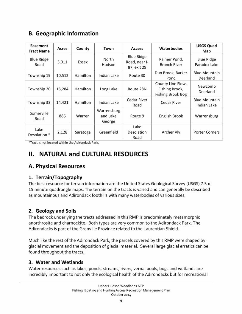
B. Geographic Information Easement
Tract Name Acres County Town Access Waterbodies USGS Quad Map
Blue Ridge Road 3,011 Essex North
Hudson
Blue Ridge Road, near I-
87, exit 29
Palmer Pond, Branch River
Blue Ridge Paradox Lake
Township 19 10,512 Hamilton Indian Lake Route 30 Dun Brook, Barker Pond
Blue Mountain Deerland
Township 20 15,284 Hamilton Long Lake Route 28N County Line Flow,
Fishing Brook, Fishing Brook Bog
Newcomb Deerland
Township 33 14,421 Hamilton Indian Lake Cedar River Road Cedar River Blue Mountain
Indian Lake
Somerville Road 886 Warren
Warrensburg and Lake George
Route 9 English Brook Warrensburg
Lake Desolation * 2,128 Saratoga Greenfield
Lake Desolation
Road Archer Vly Porter Corners
*Tract is not located within the Adirondack Park.
II. NATURAL and CULTURAL RESOURCES
A. Physical Resources
1. Terrain/Topography The best resource for terrain information are the United States Geological Survey (USGS) 7.5 x 15 minute quadrangle maps. The terrain on the tracts is varied and can generally be described as mountainous and Adirondack foothills with many waterbodies of various sizes.
2. Geology and Soils The bedrock underlying the tracts addressed in this RMP is predominately metamorphic anorthrosite and charnockite. Both types are very common to the Adirondack Park. The Adirondacks is part of the Grenville Province related to the Laurentian Shield. Much like the rest of the Adirondack Park, the parcels covered by this RMP were shaped by glacial movement and the deposition of glacial material. Several large glacial erratics can be found throughout the tracts.
3. Water and Wetlands Water resources such as lakes, ponds, streams, rivers, vernal pools, bogs and wetlands are incredibly important to not only the ecological health of the Adirondacks but for recreational
Upper Hudson Woodlands ATP
Fishing, Boating and Hunting Access Recreation Management Plan October 2014
4
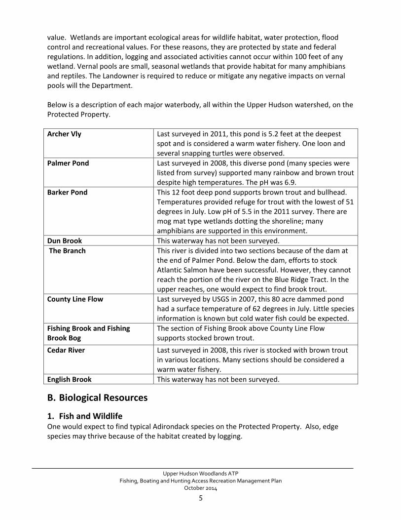
value. Wetlands are important ecological areas for wildlife habitat, water protection, flood control and recreational values. For these reasons, they are protected by state and federal regulations. In addition, logging and associated activities cannot occur within 100 feet of any wetland. Vernal pools are small, seasonal wetlands that provide habitat for many amphibians and reptiles. The Landowner is required to reduce or mitigate any negative impacts on vernal pools will the Department. Below is a description of each major waterbody, all within the Upper Hudson watershed, on the Protected Property. Archer Vly Last surveyed in 2011, this pond is 5.2 feet at the deepest
spot and is considered a warm water fishery. One loon and several snapping turtles were observed.
Palmer Pond Last surveyed in 2008, this diverse pond (many species were listed from survey) supported many rainbow and brown trout despite high temperatures. The pH was 6.9.
Barker Pond This 12 foot deep pond supports brown trout and bullhead. Temperatures provided refuge for trout with the lowest of 51 degrees in July. Low pH of 5.5 in the 2011 survey. There are mog mat type wetlands dotting the shoreline; many amphibians are supported in this environment.
Dun Brook This waterway has not been surveyed. The Branch
This river is divided into two sections because of the dam at the end of Palmer Pond. Below the dam, efforts to stock Atlantic Salmon have been successful. However, they cannot reach the portion of the river on the Blue Ridge Tract. In the upper reaches, one would expect to find brook trout.
County Line Flow
Last surveyed by USGS in 2007, this 80 acre dammed pond had a surface temperature of 62 degrees in July. Little species information is known but cold water fish could be expected.
Fishing Brook and Fishing Brook Bog
The section of Fishing Brook above County Line Flow supports stocked brown trout.
Cedar River
Last surveyed in 2008, this river is stocked with brown trout in various locations. Many sections should be considered a warm water fishery.
English Brook This waterway has not been surveyed.
B. Biological Resources
1. Fish and Wildlife One would expect to find typical Adirondack species on the Protected Property. Also, edge species may thrive because of the habitat created by logging.
Upper Hudson Woodlands ATP
Fishing, Boating and Hunting Access Recreation Management Plan October 2014
5

2. Endangered, Threatened and Species of Special Concern Endangered Peregrine Falcon – These birds, listed in NY as an endangered species are known to nest on high ledges, 50 to 200 feet off the ground. Populations drastically declined in the 1940’s due to DDT exposure. Release programs initiated by the Peregrine Fund in the mid 1970's have resulted in peregrine falcons breeding in New York once again. In 1998, 38 pairs were present in New York, 36 bred, 31 were successful and 69 young fledged. New urban nests have been reported upstate for the first time in Albany. Gradual increases in the breeding population have been recorded throughout the east. Peregrine falcons are recorded to nest on cliffs located on the Township 33 tract. The proposed fishing corridor and parking areas on this tract are far from the cliffs. Threatened Timber Rattlesnake – These large venomous snakes measure 3 - 4.5 feet in length and seek open, rocky south facing slopes surrounded by hardwood forests as habitat. While most of the tracts do not support their desired habitat, the timber rattlesnake has been found in the Lake George region near the Somerville Tract. New York Protected Species Special Concern Species are those native species which are not yet recognized as endangered or threatened, but evidence exists relating to their continued welfare in New York State. The Special Concern category exists within DEC rules and regulations, but such designation does not in itself provide any additional protection. However, Special Concern species may be protected under other laws. The Breeding Bird Atlas is the most comprehensive list of bird species that are seen or heard in “blocks”. The blocks encompass an area larger than all the individual tracts addressed in this RMP so it is only likely, not definite, that the listed species reside for some or part of the year. The following are listed on the 2000-2005 Breeding Bird Atlas as protected species of Special Concern in New York State: Bicknell's Thrush Common Loon Sharp-shinned Hawk Red-shouldered Hawk Cooper's Hawk Northern Goshawk Osprey Rusty Blackbird New York State completed the Herp (herpetofauna) Atlas Project in 1999 with similar methodology to the Breeding Bird Atlas. Beginning in 1990, the DEC surveyed for all herpetofauna, which is the general term for frogs, toads and salamanders, turtles, snakes and
Upper Hudson Woodlands ATP
Fishing, Boating and Hunting Access Recreation Management Plan October 2014
6

lizard. Potentially located on the Protected Property and on the list of NY Species of Special Concern are the following:
Jefferson Salamander Blue Spotted Salamander Eastern Spadefoot Toad Spotted Turtle Wood Turtle
3. Natural Heritage Program Elements of Occurrence
Significant Communities Riverside Sand and Gravel Bar – While unlikely, the potential for this community to occur begins at the western side of Palmer Pond on the Blue Ridge Tract. The community is generally found on the sandy banks of the Schroon River. Sedge Meadow – This relatively small, remote community is located on Desolation Road Tract. The sedge meadow is co-dominated by tussock sedge and blue-joint grass over shallow peat and muck. Spruce Fir Swamp – This relatively small, remote red spruce dominated swamp is located on the Desolation Road Tract. The swamp is part of a wetland complex that forms the headwaters of a small unnamed stream that drains into Lake Desolation.
4. Invasive Species As global trade and travel have increased, so have the introduction of non-native species. While many of these non-native species do not have adverse effects on the areas in which they are introduced, some become invasive in their new ranges, disrupting ecosystem function, reducing biodiversity and degrading natural areas. Invasive species can damage native habitats by altering hydrology, species composition, fire frequency, soil fertility and other ecosystem processes. Invasive species have been identified as one of the greatest threats to biodiversity, second only to habitat loss. Invasive insects are commonly found in recreational areas and can be incredibly destructive to forested landscapes. Several invasive insects, hemlock woolly adelgid, emerald ash borer and Asian longhorn beetle have been detected in trees bordering the Adirondack Park. They have not made their way inside the Blue Line but pose a significant threat. The story is different for many invasive plants. The best source of information on exact locations of invasive species is the imapinvasives webpage. While no invasive species have been recorded on the Property, many species are in close proximity. These include Eurasian water milfoil, purple loosestrife, common reed, garlic mustard, giant hogweed, wild parsnip and Japanese knotweed. It is expected that some of these species are on the Property but are not yet in the database. Other species that are considered a considerable threat to the Adirondack Park are yellow iris, Russian olive, oriental bittersweet and hydrilla.
Upper Hudson Woodlands ATP Fishing, Boating and Hunting Access Recreation Management Plan
October 2014
7

C. Cultural Resources
1. Cultural and Archaeological Areas of Archaeological sensitivity are found on many of the tracts. These are sites that OPRHP has identified as potential archaeological sites. While the sites are in close proximity to planned construction or management actions, there will be no interference with the sites. However, the Desolation Road Tract is within the Mohawk Valley Heritage Corridor. Specifically, the Glass Factory Village is within the general area of Mount Pleasant and is listed as an archeological site of sensitivity. The glass bottles supplied the water bottling industry in Saratoga Springs. This village was settled in 1844 and abandoned in 1868. The archeological site is not within the proposed area of development. Sensitivity will be given to the site during construction due to its proximity.
2. Wild, Scenic and Recreational Rivers In 1972, State legislation was passed creating a designated rivers system called the Wild, Scenic and Recreational Rivers Act. This Act protects and maintains certain designated rivers on State and private lands in their free-flowing condition and natural setting. The Cedar River is classified as a scenic river in the area where management actions are proposed under the Wild Scenic and Recreational Rivers Act. A scenic river is “…generally free of diversions or impoundments with limited road access. Their river areas are essentially primitive and undeveloped or are used for agriculture, forest management and other dispersed human activities which do not in themselves substantially constrain public use and enjoyment of these rivers and their environs. Management of scenic river areas will be directed to preserving and restoring their natural scenic qualities.” (6 NYCRR Part 666.4) The Branch River is classified as a Study River for possible inclusion under the Wild, Scenic and Recreational Rivers System Act. Lands within one quarter mile of any study river, except in hamlet and industrial use areas identified on the Adirondack Park land use and development plan map, are statutory “critical environmental areas”. These rivers are to remain free-flowing with essentially primitive shorelines (Adirondack Park Agency Rules and Regulations, Appendix Q-8). Virtually all land uses and developments will require an Adirondack Park Agency permit. (Appendix Q-5)
D. Economic Impact The Upper Hudson Woodlands Easement recognizes the economic impact of the logging industry on Adirondack Park communities. The Easement specifically reserves the tracts as working forests and provides dedicated public recreation areas. This is considered an economic benefit for the Towns in which the tracts are located, as well as the entire Adirondack Park. Tourism and outdoor recreation are growing industries and increasingly more influential in Adirondack community economies.
Upper Hudson Woodlands ATP
Fishing, Boating and Hunting Access Recreation Management Plan October 2014
8

III. LANDOWNER MANAGEMENT AND USE
A. Property History While Upper Hudson Woodlands ATP is a relatively new owner of the Protected Property, Finch Pruyn and Company were the previous owners for almost a century. The long history of timber harvesting, not unlike much of the Adirondacks, is depicted on the landscape with many timber stands in various stages of growth, hunting camps, ATV trails and foot paths traversing the landscape.
B. Current Forestry Uses A stated purpose of the Easement on this Property is to ensure that the forest resource will continue to be available to the current and future landowners for viable, sustainable forest management and the associated long-term production of forest products. It is common to see foresters, loggers, and logging equipment on the Property, and the people using the Property for recreation can expect to encounter this type of activity during a typical visit.
C. Current Non-Forestry Uses of the Property
1. Recreational Leases Several private hunting clubs lease recreational camps from Upper Hudson Woodlands ATP, with exclusive hunting rights. While they are most active during the big-game hunting season, several lease holders use their camps for a wide variety of four-season outdoor-based recreation. Per terms of the timber easement, private recreation club members are permitted to use motorized vehicles on landowner specified roads, trails and waterways. 2. Snowmobiling Trails The existing snowmobile trails, or multiple use trails, addressed in this plan were established by New York State via the January 2011 Snowmobiling Interim Recreation Management Plan. All of the snowmobile trails proposed in the IRMP were existing snowmobile trail connections that have been open to public snowmobile use in the past and will remain unchanged. The routes provide important connections between communities and constitute links in the snowmobile trail network. The multiple use trails in this plan are generally located on logging roads. Snowmobile trail maintenance and grooming will be limited to what has previously been allowed, is within the OPRHP guidelines and as prescribed by provisions in the Easement. As such, DEC determined that the above action will result in no change in public snowmobile use and as a result this RMP and will not have a negative impact on adjacent Forest Preserve.
Upper Hudson Woodlands ATP
Fishing, Boating and Hunting Access Recreation Management Plan October 2014
9

D. Property Infrastructure
1. Existing Infrastructure Due to the nature of the Property as a working forest with recreational leases, an intricate system of roads, ATV and foot trails have been developed. Many of the features outlined in this RMP are preexisting. • All motorized use corridors proposed within this plan are on existing logging roads. (Per the
Easement, public ATV use is not allowed on the Property). • Car-top boat launch sites and trailer boat launch sites are established but have not
previously been available for public use. • Many of the parking areas are preexisting or located on cleared areas. • Fishing Brook Bog and County Line Flow were created by dams on the Protected Property.
2. Gravel Pits Sand and gravel originating on the Protected Property shall not be deposited, sold, or used off the property except, the Landowner and the Department may transport and use sand and gravel for the maintenance on portions of public roads within one mile of the Property that provide access to the Property, pass through the boundary of the Property or for the purpose of maintaining existing private access road right-of way leading to and from the Property. In order to minimize negative environmental impact and maintain forested areas, parties should use existing sand and gravel pits when practical, and avoid opening new pits unless necessary. New pits are those not identified in the Baseline Documentation. To create a new pit, the Landowner must approve the area or location from which sand and gravel are to be extracted by the Department. Parties will make every effort to avoid sensitive areas, minimize visual impacts and comply with any and all applicable laws and regulations when extracting sand and gravel.
IV. RELATIONSHIP OF PROPERTY TO ADJACENT LANDS
A. Public Property
1. Forest Preserve Lands Conservation easements are often designed to border Forest Preserve. This protects the State’s interests by reducing fragmentation, water quality degradation and consumptive uses near the large tracts of Forest Preserve. Unit Management Plans for each unit can be found on the DEC’s webpage. The following units border the Protected Property addressed in this RMP:
• High Peaks Wilderness • Dix Mountain Wilderness • Hoffman Notch Wilderness • West Canada Lake Wilderness • Lake George Wild Forest • Blue Mountain Wild Forest
Upper Hudson Woodlands ATP
Fishing, Boating and Hunting Access Recreation Management Plan October 2014
10

• Wilcox Lake Wild Forest
2. Other State Owned Property • Lake Desolation State Forest is located along the northern boundary of the Lake
Desolation Conservation Easement tract. • The Department of Transportation (DOT) owns a right-of-way along all state roads. They
have been consulted during the planning process.
B. Private Property Within the Adirondack Park, state-administered environmental and land use controls, including the regulations of the Adirondack Park Agency (APA), the Freshwater Wetlands Act and the Wild, Scenic, and Recreational Rivers Act, require protection of and setback of development from important environmental resources thus protecting open space. Within the Adirondack Park, the Property itself is generally classified by the APA as “Resource Management” land. As facilities build-out is planned and executed, projects will be evaluated, designed and implemented in compliance with various APA permitting requirements. Adjacent to the Property are privately-owned lands, most of which are classified as “Resource Management”, “Rural Use” or “Low Intensity.”
V. PUBLIC USE ADMINISTRATION AND MANAGEMENT The Department has responsibility for managing public access and recreation in a manner consistent with the terms and provisions of the Easement. The Department will retain this underlying authority and responsibility even in situations in which it may approve another organization to serve as a partner. Successful implementation of this RMP will require frequent communication among all parties involved in the management of the Property, including the Department, the Landowner and partners.
A. Laws, Policies and Memoranda
This RMP has been developed within the constraints and guidelines set forth by Article 9 of the Environmental Conservation Law; Parts 190 -199 of Title 6 NYCRR of the State of New York; established Department policy; and the terms and conditions of the Easement that encumbers the Property. Department Policies 1. Motor Vehicle Access to State Lands Under the Jurisdiction of DEC for People with
Disabilities (CP-3) 2. Temporary Revocable Permits for State Lands and Conservation Easements (ONR-3)
Upper Hudson Woodlands ATP
Fishing, Boating and Hunting Access Recreation Management Plan October 2014
11

3. Volunteer Stewardship Agreements (CP-58)
State Administered Land Use Controls 1. Freshwater Wetlands Act 2. Regulations of the Adirondack Park Agency
DEC/APA MOU MOU Concerning State-Owned Conservation Easements on Private Lands within the Adirondack Park. August 13, 2010
B. Regulatory Requirements, Approvals and Procedures Some of the guiding laws, policies, and legal documents outlined above specify certain requirements and approvals that must be met in the management of land and public recreation, and is pertinent to the formulation and implementation of this RMP. Americans with Disabilities Act and Americans with Disabilities Accessibility Guidelines Application of the Americans with Disabilities Act The Americans with Disabilities Act (ADA), along with the Architectural Barriers Act of 1968 (ABA) and the Rehabilitation Act of 1973; Title V, Section 504, have had a profound effect on the manner by which people with disabilities are afforded equality in their recreational pursuits. The ADA is a comprehensive law prohibiting discrimination against people with disabilities in employment practices, use of public transportation, use of telecommunication facilities and use of public accommodations. Title II of the ADA requires, in part, that reasonable modifications must be made to the services and programs of public entities, so that when those services and programs are viewed in their entirety, they are readily accessible to and usable by people with disabilities. This must be done unless such modification would result in a fundamental alteration in the nature of the service, program or activity or an undue financial or administrative burden. Consistent with ADA requirements, the Department incorporates accessibility for people with disabilities into the planning, construction and alteration of recreational facilities and assets supporting them. This RMP incorporates an inventory of all the recreational facilities or assets supporting the programs and services available to the public on the Property, and an assessment of the programs, services and facilities on the unit to determine the level of accessibility provided. In conducting this assessment, the Department employs guidelines which ensure that programs are accessible, including buildings, facilities, and vehicles, in terms of architecture and design, transportation and communication to individuals with disabilities. A federal agency known as the Access Board has issued the ADA Accessibility Guidelines (ADAAG) for this purpose. An assessment was conducted, in the development of the Public Access for Fishing, Boating and Hunting RMP, to determine appropriate accessibility enhancements which may include developing new or upgrading of existing facilities or assets. The Department is not required to make each of its existing facilities and assets accessible so long as the Department’s programs,
Upper Hudson Woodlands ATP
Fishing, Boating and Hunting Access Recreation Management Plan October 2014
12
taken as a whole, are accessible. The recreational features outlined in the Upper Hudson ATP Working Forest Easement address accessibility as a whole.
For copies of any of the above mentioned laws or guidelines relating to accessibility, contact the Department’s Universal Access Program Coordinator or visit http://www.dec.ny.gov/outdoor/34035.html. Adirondack Park Agency (APA) Land managers will need to consult with the Adirondack Park Agency where recreation management actions on land within the Adirondack Park involve activities such as: improvements or actions within or adjacent to freshwater wetlands; improvements or actions along or adjacent to the shorelines of water bodies; improvements or actions along or adjacent to Wild, Scenic, or Recreational Rivers, including study rivers. This Draft RMP has been reviewed by APA staff in accordance with the procedures outlined in the DEC/APA MOU. Certain proposed recreation projects and activities, as covered in the MOU, may require appropriate APA consultation under Section 814 of the Adirondack Park Agency Act.
C. Guidelines and Standards Development and implementation of this RMP shall be consistent with the following specific guidelines: Standards for Public Recreational Roads and Trails The Department shall decide whether portions of trails and roads shall be repaired, improved, relocated, or if public use shall be temporarily suspended based on the standards the Department uses on State forest lands (DEC Unpaved Forest Road Handbook, August, 2008). In addition, roads and trails will be constructed and maintained with deference to the road standards that have been mutually agreed to by the landowner and the Department. 2014 DEC Standard Accessible Designs for Outdoor Recreational Facilities Guidebook As DEC continues to expand outdoor recreation opportunities, the design process will continue to incorporate research and ingenuity to harmonize accessibility and Universal Design principles to provide a quality visitor experience on state lands, including state easements. All-Terrain Vehicle Use Public ATV use is not permitted per the Conservation Easement terms. Private Lessees Planning for public recreation on the Property shall acknowledge and take into consideration the Landowner's private rights (Recreation, Forest Management, etc) and attempt to avoid or minimize conflict between public and private users where possible. The Department and Landowner agree that a sticker system be implemented by the Landowners to provide enforcement with a way to identify trespassers.
Upper Hudson Woodlands ATP
Fishing, Boating and Hunting Access Recreation Management Plan October 2014
13
D. Management Authority, Staff and Responsibility The Regional Natural Resources Supervisor is the Manager of regional staff in the Department Division of Lands and Forests, the Division of Fish, Wildlife and Marine Resources and the Division of Mineral Resources. The Department Division of Lands and Forests has primary responsibility for managing public use of the lands subject to this RMP, including development of this Plan, development of individual work plans and schedules, and coordination of all activities with the Landowner, partners, and other Department Divisions. The Division of Operations, at the direction of the Division of Lands and Forests, will oversee construction and maintenance of facilities approved by this RMP. The Regional Forester has overall responsibility for these matters. Reporting to the Regional Forester is a Supervising Forester who is responsible for forestry and land management programs. Reporting to the Supervising Forester are one or more Foresters or Natural Resource Planners that may be assigned to specific tasks in preparing or implementing this Plan. The Regional Fisheries Manager and Regional Wildlife Manager are responsible for all Division of Fish and Wildlife activities. The Office of Public Protection will be responsible for enforcement of laws and Department rules and regulations. Environmental Conservation Officers and Forest Rangers have primary responsibility for monitoring and enforcement of public use of the Property. A Land Manager will be designated by the Regional Forester as the lead Department staff person for developing and implementing this and subsequent plans for the Property. The Land Manager will be responsible for: • Overseeing the coordination and preparation of the RMP, as well as periodic updates,
revisions, or amendments; • Coordinating the implementation of this and subsequent RMPs; • Overseeing the budget outlined in the RMP; • Assuring that management activities of all Department Divisions, as they relate to this RMP,
comply with applicable laws, regulations, policies, and easement terms; • Monitoring resource conditions and public use; addressing conflicts; and assessing the
effectiveness of the RMP in addressing resource protection and public needs; • Fostering communication about management activities within DEC, between DEC and the
Landowner, and between DEC and the public. The Land Manager will be the primary liaison with the Landowner regarding public access and use issues.
The development of this RMP has primarily involved Department staff and the Landowner’s land management staff, and communication and coordination of planning efforts between the parties have been critical to formulating management objectives and proposals. Consistent administration and communication is extremely important in preparing and implementing this RMP and adhering to the terms of the Easement. Department staff will regularly communicate with the Landowner to review completed activities, address concerns or problems, and coordinate future work.
Upper Hudson Woodlands ATP
Fishing, Boating and Hunting Access Recreation Management Plan October 2014
14

E. Public Recreation Management Principals, Goals and Objectives
1. Management Principles The following principles, consistent with the public recreation right acquired, will be used to manage public use of the easement Property:
• Manage public recreational use and access to the property as a composite resource • Protect and conserve natural resources with an understanding of carrying capacity • Make public use compatible with active forest management • Provide a variety of outdoor recreational uses • Protection of public safety and private property
2. Management Goals and Objectives The goals and objectives for managing public recreational use of the Easement Property must consider a variety of stakeholder interests, public expectations, and the use and ownership of the Property by the Landowner. The goals presented below are general statements about desired outcomes, while the objectives are more specific and are intended to provide guidance on how to achieve the goals. Goals: • Provide reasonable public access to the Property for the purpose of allowing the public to
enjoy the permitted range of outdoor recreational opportunities. • Avoid or minimize negative impacts of public recreational use on the natural resources and
environmental benefits of the Property. • Avoid or minimize conflicts between public recreational use and forest management
activities conducted by the Landowner. • Avoid or minimize conflicts between public recreational use and private lessee use of the
Property. • Develop a better understanding of the natural resources, environmental benefits, and
public recreation opportunities and limitations on the Property.
Objectives: • Maintain the quality of the public’s recreational experience by separating or minimizing
potentially conflicting uses where possible. • Provide safe and sanitary conditions for public recreation. • Provide for multiple motorized and non-motorized recreational uses on roads and trails,
except where the potential for resource impacts, risk to public safety, conflicts with forest management activities, or other conditions make such shared use unacceptable.
• Maintain and improve opportunities for motor vehicle access on designated roads, trails and other suitable areas of the property.
• Periodically assess the impacts of recreational uses on other recreational uses, forest management activities, and natural resources.
• Actively manage the type, level, and location of recreational uses to minimize significant conflicts between recreational activities and commercial forest management activities, and
Upper Hudson Woodlands ATP
Fishing, Boating and Hunting Access Recreation Management Plan October 2014
15

to minimize adverse impacts to fish, wildlife, important habitats, water quality, and other natural resources and environmental values on the Property.
• Promote partnerships with the Landowner and/or recreational constituencies and secure assistance as necessary to complete management actions.
• Assess the potential for integrating new or expanded public outdoor recreational uses on the Property in a manner that is consistent with the terms of the Easement and the goals and objectives outlined above.
3. Best Management Practices All public recreation management activities will incorporate the use of Best Management Practices (BMPs) to the greatest practical extent. BMPs are those methods, procedures, and devices that are designed to prevent or minimize soil erosion, water run-off, damage to natural resources or wildlife habitat, pollution, pathogens, or other negative environmental impacts when conducting various management activities. BMPs related to the implementation of public access and recreational improvements on the Property may include, but need not be limited to, such considerations as: • Locating improvements away from streams, wetlands, and unstable slopes. • Locating improvements to minimize necessary cut and fill. • Locating camping sites or other structures on flat, stable, well-drained sites. • Locating roads on existing old roads or cleared, or partially cleared areas. • Locating trails to minimize grade and avoid streams, wetlands, and unstable slopes. • Avoiding areas where threatened and endangered species are known to exist. • Limiting the size of parking lots and other improvements to the minimum necessary to meet
the intended use. • Minimizing tree cutting. • Using proper drainage devices, such as water bars and broad-based dips, to prevent erosion
and damage to improvements. • Using stream crossings with low, stable banks, firm stream bottom, and gentle approach
slopes. • Constructing roads, trails, bridges and other stream crossings at right angles to the stream. • Limiting stream crossings and construction on or near streams to periods of low flow. • Designing, constructing, and maintaining bridges and other improvements on or near
streams to avoid disrupting or preventing movement of fish and other aquatic species. • Minimizing the use of equipment in streams. • Using soil stabilization practices on exposed soil around construction areas, especially
bridges, immediately after construction.
VI. CONSERVATION EASEMENT AFFIRMATIVE RIGHTS The Conservation Easement that pertains to the Property covered by this RMP grants the State of New York a legal interest in the Protected Property, sets forth terms, restrictions, and rights
Upper Hudson Woodlands ATP
Fishing, Boating and Hunting Access Recreation Management Plan October 2014
16

with respect to the Property, and establishes a framework for administering public recreation access rights acquired by the State. The specific terms of the Easement were developed through negotiations between the State and the Landowner and have resulted in a guaranteed right for the State to permit limited public access to the Property and participation in certain outdoor recreation activities.
A. Recreation Access and Use Rights The Conservation Easement grants the public permanent rights of access to the Property for outdoor recreational use, subject to the specific terms in the recorded Easement document agreed to by the State and the Landowner. All management actions on the Property, as implemented through this RMP, will be conducted in accordance with those specific Easement terms and will consider and strive to be consistent and compatible with, the reserved rights of the Landowner. Permitted public recreational activities, as proposed in this RMP, are designed to have limited impacts on the natural resources of the Property, on the Landowner’s management of the Property for forest products and on private lessees. The following affirmative rights, subject to specific terms, conditions, requirements, limitations, and restrictions stated in the Easement and described below, have been granted to the State of New York and apply directly to the development and implementation of this RMP:
1. Public Recreational Amenities and Improvements The Department may establish, construct, use, repair, maintain, improve, expand, relocate, replace, demolish, abandon, or remove recreational amenities and improvements within the Property, including Public Access Corridors, Public Fishing Corridors, Public Recreational Use Areas and along and within Linear Recreation Corridors, including those set forth in the terms of the Easement. Recreational Amenities and improvements may include roads, trails, Parking Areas, boat launches, car-top boat launches, campsites, outhouses, fire rings, fire places, signs, kiosks, barriers, fences, gates, and other such structures or improvements used in connection with, or to facilitate, the management of public access and Public Recreational Uses of the Protected Property. In the event that the Department may delegate the construction or maintenance of recreational amenities to other entities, such as a local municipality or authorized clubs, the Department shall provide written notice to the Landowner. Such delegation shall not curtail the rights and responsibilities of the Department defined within the Easement. The Department may develop certain improvements, amenities, or limited facilities necessary to support permitted and approved public access and use of the Property. This right includes
Upper Hudson Woodlands ATP
Fishing, Boating and Hunting Access Recreation Management Plan October 2014
17

the ability to designate, and in some cases construct, roads and trails on the Property for public access and use, including accessible trails for people with disabilities.
2. Non-motorized Access - Use and Activities DEC has the right to provide public access to the property for a variety of dispersed, non-motorized outdoor recreational activities, such as: hiking, bicycling, snowshoeing, cross-country skiing, photography, bird watching, wildlife observation, picnicking, boating (with car-top watercraft such as canoes, kayaks, or rowboats), swimming, camping at designated campsites, horseback riding, dog-sledding, fishing, hunting, and trapping. These activities will be permitted year-round in Public Use Areas. Some non-motorized corridors will be closed during the Northern Big Game season. Current regulations determine this as the second-to-last Saturday in October until the first Sunday in December, or such a time determined by future regulations.
3. Motorized Access - Use and Activities The Department has the right to allow public motor vehicle access to the Property via certain designated routes. These routes will be signed accordingly as being open to certain types of motor vehicles, such as passenger vehicles, snowmobiles or motor boats. Speed limits and other restrictions or safety information will also be posted. ATVs are not a permitted public use.
4. Public Fishing Corridors The State acquired public access and Public Recreational Use, as defined by the Easement, for fishing in accordance with applicable laws and regulations. Public Recreational Use within Public Fishing Corridors includes any Non-Motorized Public Recreational Uses, including hiking and boating. The Department will establish and sign the boundaries of designated Public Fishing Corridors. The Department may establish the recreational amenities as described in the Easement, including boat launches, fishing piers, parking areas, public use areas and associated access roads and trails.
Public Fishing Corridors include the area of the Property located within thirty-three (33) feet upland of the Mean High Water Mark (MHWM) of the respective stream, river, pond or water-body as shown in the Exhibits, unless indicated otherwise. The corridor includes the bed of the waterbody. Not all ponds have a designated 33 foot fishing corridor but may have public motorized and non-motorized access. This will be clearly posted where necessary. The public may access and use Public Fishing Corridors, except for the period of time coinciding with the Northern Zone Big Game Regular Hunting Season. Established by New York State Regulations, this season is the annual period from the second-to-last Saturday in October until the first Sunday in December, or such a time determined by future regulations.
5. Public Recreational Use Areas (PUAs) PUAs are intended to provide the public with year-round access over and within the delineated areas. Allowed uses include motorized and non-motorized Public Recreational Uses, as defined by the Easement which includes camping, hunting, fishing and trapping. The Department also
Upper Hudson Woodlands ATP
Fishing, Boating and Hunting Access Recreation Management Plan October 2014
18
has the right to establish, construct, maintain, relocate or abandon Linear Recreation Corridors anywhere within these areas.
B. Other Conservation Easement Provisions Affecting Public Use
1. Barriers, Gates, and Locks The Department may install gates, signs, fences or other physical barriers necessary to carry out the proposed actions and prohibit public access to areas of the Property over which the public will not have access.
2. Parking Areas The Department may provide public parking within the Protected Property subject to the following provisions: • Parking Areas shall not exceed one-half acre in size; • Parking Areas shall be established or relocated in the general locations designated on
easement maps; • Each designated Parking Area may be constructed to accommodate any number of vehicles
deemed necessary by DEC to facilitate the uses permitted in close proximity to the Parking Area.
3. Campsites The Department may provide campsites within the Protected Property subject to the following provisions: • Campsites shall not exceed one-half acre in size; • Campsites shall be established or relocated in the general locations designated on
Easement maps; • Shall be located within 200 feet of the associated Linear Recreation Corridor unless the
landowner agrees in writing; • Foot paths shall connect Linear Recreation Corridors with campsites; • The Department will not construct lean-to’s, platforms or other structures within campsites
unless the landowner agrees in writing.
4. Search, Rescue, Fire, Emergency Response, and Law Enforcement The Department and the Landowner have the right to undertake emergency actions necessary
to preserve and protect private property interests, public recreation amenities, and human health and safety in response to natural disasters, environmental hazards, or other threats. The DEC, Environmental Conservation Police, Forest Rangers, State Police, and other emergency response personnel will have full access to the Property. Emergency response for search, fire, and rescue on the Property, as on State lands, will be coordinated by the NYS Forest Rangers though a response may include other emergency responders.
Upper Hudson Woodlands ATP Fishing, Boating and Hunting Access Recreation Management Plan
October 2014
19
VII. PROPOSED RECREATION MANAGEMENT ACTIONS AND IMPLEMENTATION
A. General Recreation Management Actions At any time, the Department, in its sole discretion, may determine to initiate, limit, restrict or temporary eliminate any recreational uses granted in the Easement. The Department will create work plans for all further management actions. General management of the Protected Property will include:
1. Location of Boundaries The Department shall mark the location of the boundaries for Public Use Areas and Public Fishing Corridors.
2. Signs Following the Conservation Easement Public Recreation Road and Trail Sign Guidance Manual, the Department shall install and maintain appropriate signs in order to advise the public of the permitted recreational activities in Public Fishing Corridors, Linear Recreation Corridors, Access Corridors and Public Use Areas. Signs shall indicate the time of year that the Corridors are closed to the public. In all instances, roads open for Motorized Public Recreational Use associated with Public Fishing Corridors, parking areas and boat launches shall be specifically marked with appropriate signs for the type(s) of vehicle(s), activities permitted, and other necessary rules and regulations. The Property owners shall agree to the content of signs installed on the Protected Property by the Department.
3. Logging Closure Zones The Landowner reserves the right to close trails or roads during logging in consultation with the Department. Logging closure zones shall not be in place for more than 6 months unless extended by mutual agreement between the Landowner and the Department. The Landowner is responsible for placing adequate and appropriate signs where public roads and trails enter Logging Closure Zones. If a feasible re-route exists, the Landowner will work with the Department to ensure that it is opened.
4. Shared Road Maintenance The Easement provides general guidance on how the costs of maintaining improvements are to be shared. The Department and the Landowner will share the expense of any maintenance or replacement of improvements in public use based on the proportionate amount of use and benefit that each party derives from the open and accessible improvement (except for shared bridges which the parties will share equally in the cost of replacement). An annual maintenance plan that represents each party’s share of the maintenance cost will be developed
Upper Hudson Woodlands ATP
Fishing, Boating and Hunting Access Recreation Management Plan October 2014
20

by both parties individually with due consideration to their respective annual budgets and work-plans, and shall be agreed to each year at the annual meeting. When considering cost-sharing arrangements, it is important to mention that neither party is responsible for assuming a cost that is not commensurate with the interest they have in a particular shared improvement. With that in mind, the Department is solely responsible for incurring costs unique to providing for public access and use; likewise, the Landowner is solely responsible for incurring costs unique to providing for their reserved rights in the Property. Any damage caused by public recreational activities shall be the responsibility of the Department to repair. Any damage caused by the Landowners activities (for example logging operations or the lease holders) shall be the responsibility of the Landowner to repair. When roads and trails are constructed by the Department, they will be generally built to the standards the Department uses on State forest lands (DEC Unpaved Forest Road Handbook, August, 2008). In addition, roads and trails will be constructed and maintained with deference to the conservation easement road standards that have been mutually agreed to by the landowner and the Department. During construction and maintenance, Best Management Practices (BMPs) will be utilized to protect the natural resources (also see BMP Field Guide at DEC website): www.dec.ny.gov/docs/lands_forests_pdf/dlfbmpguide.pdf
5. Monitoring Department Natural Resource Supervisors are responsible for the annual inspection of all lands under Department jurisdiction including lands over which New York State holds an easement. After notification, an inspection to determine Landowner adherence to affirmative rights, Landowner compliance and Landowner activities should be carried out by the Department. Required annual meetings will provide a chance for both parties to express and share concerns.
Upper Hudson Woodlands ATP
Fishing, Boating and Hunting Access Recreation Management Plan October 2014
21
B. Specific Recreational Activities
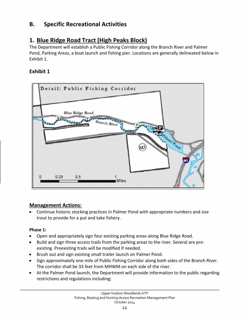
1. Blue Ridge Road Tract (High Peaks Block) The Department will establish a Public Fishing Corridor along the Branch River and Palmer Pond, Parking Areas, a boat launch and fishing pier. Locations are generally delineated below in Exhibit 1. Exhibit 1
Management Actions: • Continue historic stocking practices in Palmer Pond with appropriate numbers and size
trout to provide for a put and take fishery. Phase 1: • Open and appropriately sign four existing parking areas along Blue Ridge Road. • Build and sign three access trails from the parking areas to the river. Several are pre-
existing. Preexisting trails will be modified if needed. • Brush out and sign existing small trailer launch on Palmer Pond. • Sign approximately one mile of Public Fishing Corridor along both sides of the Branch River.
The corridor shall be 33 feet from MHWM on each side of the river. • At the Palmer Pond launch, the Department will provide information to the public regarding
restrictions and regulations including:
Upper Hudson Woodlands ATP
Fishing, Boating and Hunting Access Recreation Management Plan October 2014
22

o Limit motorized boats to a maximum of sixteen feet in length and maximum of 10 horsepower or less. This limitation will prohibit jet skis and wave runners.
o New York State fishing regulations o Invasive species spread prevention information
Phase 2: • Assess feasibility of and build a 2-3 car and trailer ADA accessible Parking Area as indicated
on Exhibit 1. • Improve the boat launch to ensure it is accessible for persons with disabilities at the Palmer
Pond site. This boat launch should be designed to accommodate small boats and trailers, and be made of natural materials.
• Build an ADA accessible privy near the boat launch. • Construct a fishing pier at Palmer Pond for persons with disabilities in proximity to the boat
launch and parking area. The pier will not exceed 300 square feet. Ideally, the pier will also allow persons with disabilities to easily get in and out of boats at the launch.
Upper Hudson Woodlands ATP
Fishing, Boating and Hunting Access Recreation Management Plan October 2014
23

2. Township 19 Tract (High Peaks Block) Exhibit 2
Within the Township 19 tract, a snowmobile trail, indicated on Exhibit 2 has been established through the Snowmobiling Interim Recreation Management Plan, January 2011. This RMP will establish the PUA and public recreation amenities within (see VI.A.5). This includes opening the O’Neil Flow Road to motorized vehicles, opening the 2 roads to campsites, building 2 parking areas and campsites and establishing a cartop boat launch on Barker Pond. O’Neil flow road will be closed during the spring for mud season. Only snowmobiles will be permitted during the winter (See 2011 Snowmobiling Interim RMP). Management Actions for Township 19 Tract: Phase I: • Ensure the O’Neil Flow Road is in proper condition to accommodate motorized vehicle
traffic. • Parking is permitted along O’Neil Flow Road. Ensure several pull-offs are created. • Install access control gates where motorized vehicles could travel outside of permitted area. • Install an informational sign/kiosk at the beginning of the O’Neil Flow road.
Upper Hudson Woodlands ATP
Fishing, Boating and Hunting Access Recreation Management Plan October 2014
24

• Post each side of the road to notify the public of allowed uses. One side of the road is a Public Use Area, the other is not.
• Improve campsite access roads to accommodate motor vehicle traffic. • Build 3 campsites and associated trails. • Build a cartop boat launch on Barker Pond.
3. Township 20 Tract (High Peaks Block)
Exhibit 3 (Not all recreational amenities shown on this map will be implemented at this time).
The Public Use Area (PUA) (see arrow in Exhibit 3) west of Public Access Corridor AM4 and two parking areas will be opened for public recreational access. This portion of the tract borders Blue Mountain Wild Forest. AM4 will be closed during the spring for mud season and during the winter months.
Upper Hudson Woodlands ATP
Fishing, Boating and Hunting Access Recreation Management Plan October 2014
25
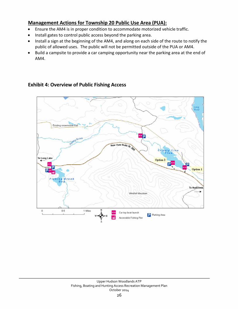
Management Actions for Township 20 Public Use Area (PUA): • Ensure the AM4 is in proper condition to accommodate motorized vehicle traffic. • Install gates to control public access beyond the parking area. • Install a sign at the beginning of the AM4, and along on each side of the route to notify the
public of allowed uses. The public will not be permitted outside of the PUA or AM4. • Build a campsite to provide a car camping opportunity near the parking area at the end of
AM4. Exhibit 4: Overview of Public Fishing Access
Upper Hudson Woodlands ATP
Fishing, Boating and Hunting Access Recreation Management Plan October 2014
26

Exhibit 5: Fishing Brook Bog
Exhibit 6: County Line Flow
Upper Hudson Woodlands ATP Fishing, Boating and Hunting Access Recreation Management Plan
October 2014
27

a) Fishing Brook Bog A Public Fishing Corridor shall be established within Fishing Brook Bog as shown on Exhibit 5. Public Recreational Use shall be limited to fishing and non-motorized boats. Electric motors are allowed. The Department may establish a Parking Area, car-top boat launch and a fishing pier in the general locations shown on Exhibits 4 and 5, preferably on the west side of Fishing Brook Bog. The features available to the public shall be designed for persons with disabilities and universal access. b) Fishing Brook A Non-Motorized Public Recreational Use Corridor and Public Fishing Corridor shall be established along and within Fishing Brook as it runs from Fishing Brook Bog to County Line Flow as it is shown on Exhibits 4 and 5. Recreational Use shall be limited to fishing and non-motorized boating. Electric motors are allowed, though are unlikely to be used due to the shallow and rocky nature of the stream. Parking Areas and two car-top boat launches shall be located along Fishing Brook as generally located on the Exhibits 4 and 5. One car-top launch will be developed along Public Access Corridor “AM5”, a forest management road on the north side of State Route 28N. The second car-top launch and Parking Area will be developed on a secondary logging road bridge site along the north side of Route 28N. c) County Line Flow A Motorized Public Access Corridor, identified as “AM6” on Exhibit 6, is an existing and well-maintained forest management road. As shown in Exhibit 6, the conservation easement language allows for the establishment of a parking area to allow public access to the cartop boat launch to the south of Route 28N. However, this location is not preferred by the landowner or the Department. The preferred location is on the north side of Route 28N near the County Line flow, where space will provide for a large ADA accessible parking area. Two alternatives are shown on Exhibit 6. Option 1, outlined as the car-top launch site on AM6 has historically been used as a boat launch. Option 2 follows an old logging road leading to a site near the water. Public Recreational Uses on County Line Flow are limited to fishing and the use of non-motorized boats. Electric motors are allowed. The public shall not be permitted upland of the MHWM on County Line Flow except at the designated Parking Area and Car-top Boat Launch site as shown on Exhibit 6. Management Actions: Phase 1: • Build a Parking Area and car-top boat launch on Fishing Brook Bog. • Ensure signage is in place on the shores of the Bog. The public is not permitted upland of
the MHWM of Fishing Brook Bog except at the designated car-top boat launch site. • Provide information regarding rules and fishing regulations at Fishing Brook Bog.
Upper Hudson Woodlands ATP
Fishing, Boating and Hunting Access Recreation Management Plan October 2014
28
• Sign Fishing Brook Public Fishing Corridor • Sign County Line Flow appropriately. The public is not permitted upland of the MHWM of
the County Line Flow except at the designated boat launch site. • Complete the two parking areas for Fishing Brook and provide information regarding
allowable uses: o One Parking Area will be located at an existing roadside pull-off on the south side of 28N
east of where Fishing Brook flows under Route 28N as shown on Exhibit 6. A path to the river will be established and marked.
o The second parking area will be located where Fishing Brook flows under a forest management road (AM5) west of County Line Flow. A gate will be installed past the parking area to prevent further access down AM5. A second gate will be installed on a spur road.
Phase 2: • Build an ADA accessible privy at the Parking Area on Fishing Brook Bog. • Build a Fishing Pier for persons with disabilities not to exceed 300 square feet close to the
boat launch and accessible parking area on Fishing Brook Bog. • Assess the feasibility of and build a car-top boat launch for small boats (10 hp or less) on
County Line Flow. Determine parking and launch option as outlined on Exhibit 6. • Investigate potential for winter snowmobile parking in this area. It is in close proximity to
“M2”, the snowmobile corridor between the towns of Long Lake and Newcomb.
Phase 3: • Establish a car-top launch and 2-3 car parking area, as determined in Phase 2, at an
appropriate location on County Line Flow as shown in Exhibit 6. • If option 1 is chosen, install a gate to control public access beyond the newly established
AM6 ADA accessible parking area/launch site. • Evaluate fishery. Stock and/or manage for native brook trout or other species if deemed
feasible.
Upper Hudson Woodlands ATP
Fishing, Boating and Hunting Access Recreation Management Plan October 2014
29

4. Township 33 (Indian Lake Block)
The Department may establish Public Fishing Corridors and Parking Areas and access trails, generally located along both sides of the Cedar River as delineated on Exhibit 7. This section of the river is easy to access because of close proximity to Cedar River Road. None of the actions or projects would cause a violation of the Wild, Scenic and Recreational Rivers Act. Exhibit 7 (Not all recreational amenities shown on this map will be implemented at this time).
Exhibit 8 Insert
Upper Hudson Woodlands ATP
Fishing, Boating and Hunting Access Recreation Management Plan October 2014
30

Exhibit 8: Parking along Cedar River Road
Management Actions:
• Appropriately sign four (4) of the five (5) segments of the Cedar River Public Fishing Corridors that share a boundary with the Forest Preserve. The corridor is 33 feet from the MHWM on either side of the river.
• Designate and upgrade as necessary two (2) of the six (6) Parking Areas as shown in Exhibit 8. Identify with appropriate signage.
• Build access paths from the 2 parking areas to the river. • Evaluate fishery. Stock and/or manage the Cedar River for native brook trout or other
species if deemed feasible.
Upper Hudson Woodlands ATP
Fishing, Boating and Hunting Access Recreation Management Plan October 2014
31

5. Somerville Road Tract (Lake George Block)
Exhibit 9 (Not all recreational amenities shown on this map will be implemented at this time).
A Public Access Corridor for Motorized Public Access, as identified as “AM8” on Exhibit 9 provides access to the Parking Area for the Public Fishing Corridor on the banks of English Brook. The existing road is generally located along English Brook. Management Actions: Phase 1: • Determine which parking area will be more appropriate for English Brook fishing access.
Phase 2: • Open and appropriately sign the English Brook Public Fishing Corridor 33 feet from the
Mean High Water Mark (MHWM) on either side of the brook. • Build a parking area on Somerville Road (road not depicted on Exhibit 9) that parallels
English Brook. Sign appropriately.
Upper Hudson Woodlands ATP
Fishing, Boating and Hunting Access Recreation Management Plan October 2014
32

• Build an access path from Somerville Road to English Brook. • Evaluate fishery. Stock or manage as appropriate or feasible.
6. Lake Desolation Road Tract (Sacandaga Block)
The Department will establish a car-top boat launch on the bank of Archer to provide for fishing and boating by the public on Archer Vly. See Exhibit 10. The Department will establish several designated Campsites and several Parking Areas within the Public Recreational Use Area. Several in-holdings will be carefully considered when finalizing work plans related to the management actions. An existing snowmobile route on M13 will remain. A 2011 fisheries survey found self-sustaining populations of chain pickerel, largemouth bass, pumpkinseed and brown bullhead in Archer Vly. It has a maximum depth of 5.5 feet and is too warm for trout.
Upper Hudson Woodlands ATP
Fishing, Boating and Hunting Access Recreation Management Plan October 2014
33

Exhibit 10
Upper Hudson Woodlands ATP
Fishing, Boating and Hunting Access Recreation Management Plan October 2014
34
Management Actions Phase I • Construct an appropriately sized Parking Area and car-top boat launch, located on the north
side of Plank Road, providing access to Archer Vly. • Public access to Archer Vly is limited to non-motorized boats. Electric motors are allowed.
Sign accordingly. • Open and appropriately sign Archers Vly for public fishing and boating. Because the entire
tract is a Public Recreational Use Area, there are not boundaries (as is the case with other Fishing Corridors). However, the public will only be allowed to use the pond until the boundaries are marked, including the boundaries of several inholdings.
• Establish several of the 5 designated campsites following Department guidelines. • Establish a trail around Archer Vly.
Phase 2 • Install gates as needed to control public access during mud season or when areas are closed
for timber operations. Several gates are already in place. • Open and sign the entire tract as a Public Use Area. This will include ensuring boundaries
are signed and information is provided on a kiosk at the parking areas regarding permitted uses of the property.
• If feasible, construct a parking area on Plank Road for vehicles entering from the east. • If feasible, improve trail and apply the Universal Trail Assessment Program.
Phase 3 • Upgrade motorized access routes. Include parking areas for public access.
VIII. COMPLIANCE
A. October 2011 - Conservation Easement Recreation Management Plan Guidance
This guidance document outlines the steps that are necessary to completing a Recreation Management Plan. All development and review process steps were completed.
B. State Environmental Quality Review Act
Upper Hudson Woodlands ATP
Fishing, Boating and Hunting Access Recreation Management Plan October 2014
35

New York's State Environmental Quality Review Act (SEQR) requires all state and local government agencies to consider environmental impacts equally with social and economic factors during discretionary decision-making. This means these agencies must assess the environmental significance of all actions they have discretion to approve, fund or directly undertake. SEQR requires the agencies to balance the environmental impacts with social and economic factors when deciding to approve or undertake an action. As the lead agency, the Department has prepared an Environmental Assessment Form and a statement of Negative Declaration.
C. Freshwater Wetlands Act The New York State Freshwater Wetlands Act requires actions in jurisdictional wetlands to be reviewed by the Adirondack Park Agency (APA). The Department works closely with the APA to delineate jurisdictional wetlands and prepare permits or variances that are needed.
D. APA/DEC MOU Concerning State Owned Conservation Easements on Private Lands within the Adirondack Park
This RMP development does not in itself constitute new land use or development. Instead, implementation of a RMP by the Department may constitute new land use and development depending upon the type, degree and intensity of recreation use. However, the Department and Agency agree that many types of recreation use do not warrant Agency review. Minor Activities requiring no agency consultation or review, Minor Activities requiring inter-agency Consultation only and activities which require agency notice and review are listed separately in the MOU. With regards to this RMP, the Agency will be consulted when implementing the parking areas and new trails.
Upper Hudson Woodlands ATP
Fishing, Boating and Hunting Access Recreation Management Plan October 2014
36
IX. IMPLEMENTATION SCHEDULE A. Schedule and Budget
P H A S E 1 Location Project Cost
Blue Ridge Road Open and sign 4 existing parking areas and associated access paths to the river $3,000
Blue Ridge Road Improve upon an existing small trailer launch on Palmer Pond. Install informational signage. $5,000
Blue Ridge Road Sign the one mile of fishing corridor on The Branch 4 staff days Township 19 Upgrade motor vehicle roads $20,000 Township 19 Install gates $3,000
Township 19 Build 3 campsites and improve cartop boat launch $3,000
Township 19 Install signage along O’Neil Flow Road and install informational kiosk $1,000
Township 20 (PUA) Build one car-camping site $1,000 Township 20 (PUA) Upgrade motor vehicle roads $5,000 Township 20 (PUA) Install gates $3,000 Township 20 Fishing Brook Bog kiosk, parking area and cartop launch $15,000
Township 20 Complete the Fishing Brook parking areas (2) and river access trails; Install signage $5,000
Township 20 Ensure proper signage is in place along all public fishing corridors (the Bog, Brook and Flow) 3 staff days
Township 20 Install gates $3,000
Township 33 Ensure proper signage is in place along all sections of public fishing corridors 3 staff days
Township 33 Build parking areas and access paths to the Cedar River (2) $5,000 English Brook Assess feasibility of Parking and fishing corridor 10 staff days
Desolation Road Build parking area, launch and sign appropriately at Archer Vly $5,000
Desolation Road Begin building campsites around Archer Vly $5,000
All Begin planning and design phase for all accessible features for construction in Phase II 20 staff days
All Begin planning and design phase for all accessible features for construction in Phase II 20 staff days
TOTALS
$82,000/ 60 staff days
Upper Hudson Woodlands ATP
Fishing, Boating and Hunting Access Recreation Management Plan October 2014
37

P H A S E 2 Location Project Cost
Blue Ridge Road Build an ADA accessible fishing pier and privy $10,000
Township 20 Build an ADA accessible privy and pier at Fishing Brook Bog $10,000
Township 20
If feasible, design boat launch and parking at preferred location on County Line Flow $1,000
Desolation Road Upgrade Plank road $7,000
Desolation Road Clearly mark and sign boundaries of PUA 10 staff days
Desolation Road Complete campsites and assess any overuse issues 10 staff days
TOTALS $28,000/20 staff days
P H A S E 3
Location Project Cost
Township 20
Build boat launch and parking area for access to County Line Flow. If option 1 is chosen, install a gate to control public access beyond the newly established AM6 ADA accessible parking area/launch site. $20,000
Desolation Road Upgrade M13 for motorized use and provide parking $20,000/ 10 staff days
All Assess overuse and degradation of the resources 10 staff days
TOTALS $40,000/20 staff days
Total Cost: $150,000
Total Staff Days: 100
Upper Hudson Woodlands ATP
Fishing, Boating and Hunting Access Recreation Management Plan October 2014
38
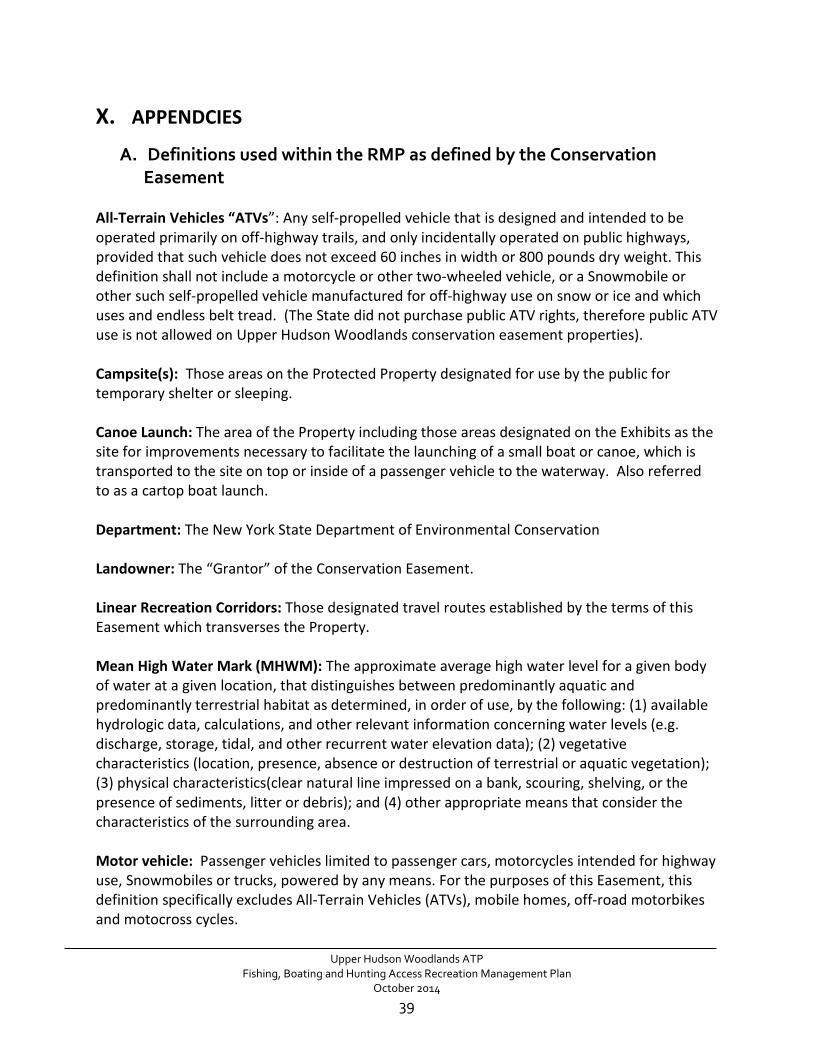
X. APPENDCIES
A. Definitions used within the RMP as defined by the Conservation Easement
All-Terrain Vehicles “ATVs”: Any self-propelled vehicle that is designed and intended to be operated primarily on off-highway trails, and only incidentally operated on public highways, provided that such vehicle does not exceed 60 inches in width or 800 pounds dry weight. This definition shall not include a motorcycle or other two-wheeled vehicle, or a Snowmobile or other such self-propelled vehicle manufactured for off-highway use on snow or ice and which uses and endless belt tread. (The State did not purchase public ATV rights, therefore public ATV use is not allowed on Upper Hudson Woodlands conservation easement properties). Campsite(s): Those areas on the Protected Property designated for use by the public for temporary shelter or sleeping. Canoe Launch: The area of the Property including those areas designated on the Exhibits as the site for improvements necessary to facilitate the launching of a small boat or canoe, which is transported to the site on top or inside of a passenger vehicle to the waterway. Also referred to as a cartop boat launch. Department: The New York State Department of Environmental Conservation Landowner: The “Grantor” of the Conservation Easement. Linear Recreation Corridors: Those designated travel routes established by the terms of this Easement which transverses the Property. Mean High Water Mark (MHWM): The approximate average high water level for a given body of water at a given location, that distinguishes between predominantly aquatic and predominantly terrestrial habitat as determined, in order of use, by the following: (1) available hydrologic data, calculations, and other relevant information concerning water levels (e.g. discharge, storage, tidal, and other recurrent water elevation data); (2) vegetative characteristics (location, presence, absence or destruction of terrestrial or aquatic vegetation); (3) physical characteristics(clear natural line impressed on a bank, scouring, shelving, or the presence of sediments, litter or debris); and (4) other appropriate means that consider the characteristics of the surrounding area. Motor vehicle: Passenger vehicles limited to passenger cars, motorcycles intended for highway use, Snowmobiles or trucks, powered by any means. For the purposes of this Easement, this definition specifically excludes All-Terrain Vehicles (ATVs), mobile homes, off-road motorbikes and motocross cycles.
Upper Hudson Woodlands ATP
Fishing, Boating and Hunting Access Recreation Management Plan October 2014
39
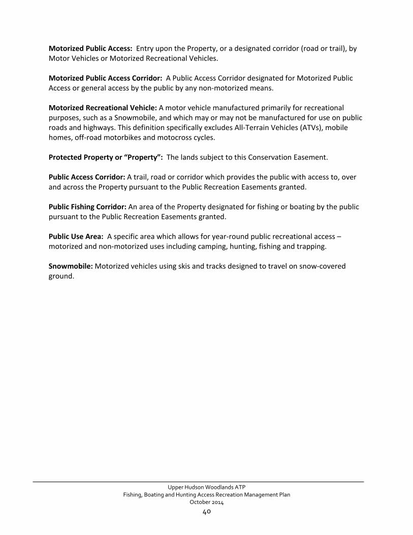
Motorized Public Access: Entry upon the Property, or a designated corridor (road or trail), by Motor Vehicles or Motorized Recreational Vehicles. Motorized Public Access Corridor: A Public Access Corridor designated for Motorized Public Access or general access by the public by any non-motorized means. Motorized Recreational Vehicle: A motor vehicle manufactured primarily for recreational purposes, such as a Snowmobile, and which may or may not be manufactured for use on public roads and highways. This definition specifically excludes All-Terrain Vehicles (ATVs), mobile homes, off-road motorbikes and motocross cycles. Protected Property or “Property”: The lands subject to this Conservation Easement. Public Access Corridor: A trail, road or corridor which provides the public with access to, over and across the Property pursuant to the Public Recreation Easements granted. Public Fishing Corridor: An area of the Property designated for fishing or boating by the public pursuant to the Public Recreation Easements granted. Public Use Area: A specific area which allows for year-round public recreational access – motorized and non-motorized uses including camping, hunting, fishing and trapping. Snowmobile: Motorized vehicles using skis and tracks designed to travel on snow-covered ground.
Upper Hudson Woodlands ATP
Fishing, Boating and Hunting Access Recreation Management Plan October 2014
40

B. Public Comment and Response Summary to Draft RMP The Department sought public comments on the Draft Fishing Boating and Hunting Public Access RMP from June 11, 2014 until July 18, 2014. A summary of concerns and the Department’s response is as follows: Public safety concerns regarding public vehicle use on logging roads. Response: The Department carefully coordinates all public recreation on logging roads with the landowners. Signage regarding road sharing and speed limits will be installed. Some areas may be temporarily closed if a conflict is anticipated. There is the potential for a re-route if the need exists. There is a need for more universally accessible public access to recreation in New York State including ATV access areas. Response: The Department also supports the public desire for increased and more convenient public access to areas where appropriate. The Upper Hudson Woodlands ATP Conservation Easement does not permit public ATV use on the property. Protection of the Glass Factory Village or Saratoga Glass Works archeological site must not be compromised. Unfulfilled actions outlined in the Saratoga County UMP (2002) include cleanup of the site, the construction of a trail and the addition of a 3-4 vehicle parking area. Response: These projects are not part of the Conservation Easement, and as outlined in the Unit Management Plan for State Forests in Saratoga and Warren Counties will be constructed as project funds become available.
Snowmobile planning must be done in a comprehensive fashion and include the required SEQRA analysis. Response: This Fishing, Boating, Hunting Access RMP does not address, or propose, the construction of snowmobile trails.
Upper Hudson Woodlands ATP
Fishing, Boating and Hunting Access Recreation Management Plan October 2014
41

C. SEQR Negative Declaration
Upper Hudson Woodlands ATP
Fishing, Boating and Hunting Access Recreation Management Plan October 2014
42
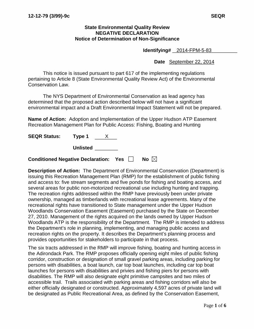
12-12-79 (3/99)-9c SEQR
State Environmental Quality Review NEGATIVE DECLARATION
Notice of Determination of Non-Significance
Identifying# 2014-FPM-5-83 Date September 22, 2014 This notice is issued pursuant to part 617 of the implementing regulations pertaining to Article 8 (State Environmental Quality Review Act) of the Environmental Conservation Law. The NYS Department of Environmental Conservation as lead agency has determined that the proposed action described below will not have a significant environmental impact and a Draft Environmental Impact Statement will not be prepared. Name of Action: Adoption and Implementation of the Upper Hudson ATP Easement Recreation Management Plan for Public Access: Fishing, Boating and Hunting SEQR Status: Type 1 X
Unlisted
Conditioned Negative Declaration: Yes No Description of Action: The Department of Environmental Conservation (Department) is issuing this Recreation Management Plan (RMP) for the establishment of public fishing and access to: five stream segments and five ponds for fishing and boating access, and several areas for public non-motorized recreational use including hunting and trapping. The recreation rights addressed within the RMP have previously been under private ownership, managed as timberlands with recreational lease agreements. Many of the recreational rights have transitioned to State management under the Upper Hudson Woodlands Conservation Easement (Easement) purchased by the State on December 27, 2010. Management of the rights acquired on the lands owned by Upper Hudson Woodlands ATP is the responsibility of the Department. The RMP is intended to address the Department’s role in planning, implementing, and managing public access and recreation rights on the property. It describes the Department’s planning process and provides opportunities for stakeholders to participate in that process. The six tracts addressed in the RMP will improve fishing, boating and hunting access in the Adirondack Park. The RMP proposes officially opening eight miles of public fishing corridor, construction or designation of small gravel parking areas, including parking for persons with disabilities, a boat launch, car top boat launches, including car top boat launches for persons with disabilities and privies and fishing piers for persons with disabilities. The RMP will also designate eight primitive campsites and two miles of accessible trail. Trails associated with parking areas and fishing corridors will also be either officially designated or constructed. Approximately 4,597 acres of private land will be designated as Public Recreational Area, as defined by the Conservation Easement,
Page 1 of 6
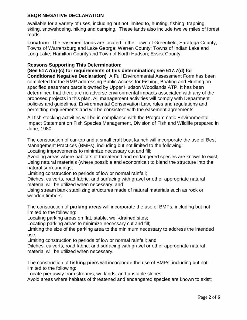
SEQR NEGATIVE DECLARATION available for a variety of uses, including but not limited to, hunting, fishing, trapping, skiing, snowshoeing, hiking and camping. These lands also include twelve miles of forest roads. Location: The easement lands are located in the Town of Greenfield; Saratoga County, Towns of Warrensburg and Lake George; Warren County; Towns of Indian Lake and Long Lake; Hamilton County and Town of North Hudson; Essex County Reasons Supporting This Determination: (See 617.7(a)-(c) for requirements of this determination; see 617.7(d) for Conditioned Negative Declaration) A Full Environmental Assessment Form has been completed for the RMP addressing Public Access for Fishing, Boating and Hunting on specified easement parcels owned by Upper Hudson Woodlands ATP. It has been determined that there are no adverse environmental impacts associated with any of the proposed projects in this plan. All management activities will comply with Department policies and guidelines, Environmental Conservation Law, rules and regulations and permitting requirements and will be consistent with the easement agreements. All fish stocking activities will be in compliance with the Programmatic Environmental Impact Statement on Fish Species Management, Division of Fish and Wildlife prepared in June, 1980. The construction of car-top and a small craft boat launch will incorporate the use of Best Management Practices (BMPs), including but not limited to the following: Locating improvements to minimize necessary cut and fill; Avoiding areas where habitats of threatened and endangered species are known to exist; Using natural materials (where possible and economical) to blend the structure into the natural surroundings; Limiting construction to periods of low or normal rainfall; Ditches, culverts, road fabric, and surfacing with gravel or other appropriate natural material will be utilized when necessary; and Using stream bank stabilizing structures made of natural materials such as rock or wooden timbers. The construction of parking areas will incorporate the use of BMPs, including but not limited to the following: Locating parking areas on flat, stable, well-drained sites; Locating parking areas to minimize necessary cut and fill; Limiting the size of the parking area to the minimum necessary to address the intended use; Limiting construction to periods of low or normal rainfall; and Ditches, culverts, road fabric, and surfacing with gravel or other appropriate natural material will be utilized when necessary. The construction of fishing piers will incorporate the use of BMPs, including but not limited to the following: Locate pier away from streams, wetlands, and unstable slopes; Avoid areas where habitats of threatened and endangered species are known to exist;
Page 2 of 6

Use natural materials (where possible and economical) to blend the structure into the natural surroundings; Whenever possible, utilize wood buffers to screen fishing pier from roads; Limit construction to periods of low or normal rainfall; and Use stream bank stabilizing structures made of natural materials such as rock or wooden timbers. The construction of privies will incorporate the use of BMPs, including but not limited to the following: Locate privies away from streams, wetlands, and unstable slopes; Locate on well drained soil; Screen from roads The construction of trails will incorporate the use of BMPs, including but not limited to the following: Locate trails away from streams, wetlands, and unstable slopes; Use of proper drainage devices such as water bars, culverts and broad-based dips; Locate trails to minimize grade; Use stream crossings with low, stable banks, firm stream bottom and gentle approach slopes; Construct stream crossings at right angles to the stream; Limit stream crossing construction to periods of low or normal flow; Avoid areas where habitats of threatened and endangered species are known to exist; Limit construction to periods of low or normal rainfall; Wherever possible, lay out trails on existing old roads or cleared or partially cleared areas; and Use stream bank stabilizing structures made of natural materials such as rock or wooden timbers. The Department’s planning and implementation of public fishing, boating and hunting rights on the portions of the property designated for such uses are consistent with the purposes of the Easement. Management activities in the RMP, along with BMPs will ensure natural resource protection and biological diversity protection, recognizing that the capacity of the property to accommodate public recreation is limited. The Department will periodically inspect recreational facilities and their use to ensure natural resource protection, compliance with the Easement terms and non-interference with the landowner’s management activities. If necessary, management changes will be made in order to resolve conflicts or mitigate resource degradation. Any enforcement violations will result in Department actions necessary to remedy these non-compliance issues. Any new construction conducted within Adirondack Park Agency (Agency) jurisdictional wetlands will occur under an appropriate wetlands permit from the Agency. Any areas disturbed will be re-seeded with native vegetation. Because the scale of these projects are relatively small and BMPs will be followed, significant or adverse environmental impacts are not expected. The projects proposed in this RMP are minor. Areas of proposed construction are generally in previously cleared areas or previously disturbed ones. Many of the parking areas are already partially developed from private use. Examples include roadside pull-offs and canoe launches.
Page 3 of 6
Small connector trails or parking areas that involve new construction or improvements will employ BMPs to minimize any potential impacts. Only one parking area at County Line Flow will be constructed, the others are pre-existing and only require upgrades. The fishing piers will be small (300 square feet) and are designed to have minimal impacts on water resources during construction. The car-top launches are not expected to be constructed within the water, except the car-top launch for persons with disabilities. Work will occur within the water for the boat launch which is designed for one small trailer. The fishing piers will have minimal shoreline impact, however, due to Adirondack Park Agency regulations, the piers will need a variance. Because of these small scale projects and use of BMPs, this is expected to have only minimal impact on the immediate and long-term environment. Project Details: The following projects are approximate and could change at the time of construction, however, only by an insignificant amount. Facilities will be closed to protect natural resources if seasonal conditions are not suitable for the established use, or if damage persists, facilities will be permanently closed. In addition, promulgating specific regulations for these lands is also possible, if conditions are warranted. The projects planned are expected to be completed over a two year period. Blue Ridge Road A parking area will be established and a fishing pier and privy for people with disabilities will be constructed with access to Palmer Pond. A small boat launch at the site, which has been historically used as such will require some brushing and improvement to the surface for accessibility. Four existing parking areas and trails to the river will be officially designated and improved as necessary. No cutting of trees will be necessary for the projects at the Blue Ridge Road tract. Township 19 Public Use Area (PUA) An existing private road, O’Neil Flow Road will be opened to the public. Few improvements are needed. Pull-offs will be improved to allow vehicles to park along the road. Three campsites will be built as well as a car top boat launch on Barker Pond. The campsites will require some clearing of brush and small trees. An existing log landing will be used as a small parking area and a formally used secondary logging road will be improved by brushing, leveling and hardening the surface to provide access to the pond. Construction of the car top boat launch will require a small amount of clearing along the shoreline. Township 20 Public Use Area (PUA) Opening the Public Use Area does not require any road upgrades or additional work to the primitive campsite. All features are pre-existing. Fishing Brook The Department will establish two parking areas and construct two access paths and two car-top boat launches for access to Fishing Brook. The parking area and car-top launch will need to be constructed on the side of a gravel road at the eastern end of Fishing
Page 4 of 6

Brook. The parking area at the western end of the brook is fairly well established with some existing gravel. Brushing and a small amount of tree clearing will be needed for an access path to the car-top boat launch from both Fishing Brook parking sites. The site has been historically used as a canoe launch and should accommodate public use. This section of the river is dependent on water levels and is likely to receive some use in the spring and only occasional use in the summer and fall when water levels permit. Fishing Brook Bog The Department will establish a parking area and construct a car-top boat launch, privy and fishing pier. All recreational features will be accessible. Fishing Brook Bog, south of Route 28N is a fairly level area and has historically been used by the landowners for launching small boats. The parking area, canoe launch and fishing pier should require little clearing and tree cutting as there is a large log landing and driveway to the southwest of the 28N bridge. The preferred location is on the west side of Fishing Brook Bog. The access driveway into the parking area will require brushing and the cutting of small trees, all less than three inches, and will require upgrading, such as culverts and gravel. The wooden boardwalk and pier will be constructed so there is minimal disturbance to wetlands or the shoreline and will involve Adirondack Park Agency staff input as early as possible. An Adirondack Park Agency variance will be required due to a structure more than 100 square feet within the mean high water mark. The addition of the wooden walkway will minimize impact over time and provide ADA access to an excellent fishing and boating location. County Line Flow The Department will construct a parking area and a car-top boat launch. The landowner has requested that the Department construct a boat launch and parking area in the location shown as option 2 in the RMP. This site is a former logging road and would allow parking to be on the same side as the launch, instead of across Route 28, as is outlined in the Easement language. Some tree cutting and fill will be necessary if option 2 is used. Township 33 Designate two parking areas and associated access trails to the Cedar River Fishing Corridor on Cedar River Road One of the two parking areas may need some leveling. The other parking area is pre-existing and does not require any modifications prior to use. Only a small amount of brushing will be needed to create river access trails, since they are in locations previously used to access the Cedar River. Somerville Road The Department will establish a short motor vehicle access route on an existing forest road. In addition, a parking area and access path to English creek will be designated. The parking area will be established at a natural pull-off and will require minimal brushing. Desolation Road Archer Vly Parking areas will be designated and a car-top boat launch will be constructed providing access to Archer Vly. The fishing access, parking areas and campsites should be accessible year round for fishing, boating and hunting. This area was heavily used by lessees, therefore land clearing for parking areas and the car-top launch will be minimal.
Page 5 of 6

Brushing will be necessary to create the five campsites. Due to higher anticipated use levels, campsite tent pads will be constructed with timbers on mineral soil. They will be level with the ground. The trail around Archer Vly will require brushing, grubbing, rock work, gravel or fill, turnpiking and a boardwalk in wet areas. Access Roads Upgrades to the road will include gravel and leveling. Several previously cleared parking pull-offs are available along Plank Road and M13. If Conditioned Negative Declaration, provide on attachment the specific mitigation measures imposed, and identify comment period (not less than 30 days from date of publication in the ENB) For Further Information: Contact Person: Allison Buckley Address: 701 South Main Street; PO Box 1316 Northville, NY 12134 Telephone Number: (518) 863-4545 x 3007 For Type 1 Actions and conditioned Negative Declarations, a Copy of this Notice is sent to: Appropriate Regional Office of the Department of Environmental Conservation Chief Executive Officer Other involved agencies Town/City/Village of other involved agencies (if any)
Environmental Notice Bulletin, NYS DEC, 625 Broadway, Albany, NY 12233-1750 (Type One Actions Only)
Page 6 of 6