parsons creek aggregates project · 2010-07-29 · parsons creek aggregates project appendix 2 june...
TRANSCRIPT

Parsons Creek Aggregates Project
APPENDIX 2: GLOSSARY AND ABBREVIATIONS

Parsons Creek Aggregates Project
Appendix 2 June 2010 Page 1
LIST OF ABBREVIATIONS% Percentº DegreeºC Degrees Celsius" inch< Less than> More than± Plus or minus7Q10 flow 10 year low flow return
period of the 7 day flowµg microgramsµg/L microgram per litreµg/m3 microgram per cubic metreµm Micrometres (microns)µS/cm MicroSiemens per
centimetre
AAAQO Alberta Ambient Air QualityObjectives
AADT Average annual daily trafficAASWQ Alberta Ambient Surface
Water QualityABMA American Boiler
Manufacturers AssociationAC Alternating currentACD Alberta Tourism, Parks,
Recreation and Culture(Community Development)
ACFN Athabasca ChipewyanFirstNation
Ae “A” horizon characterizedby eluviated clay, iron,aluminium or organic matter
AENV Alberta EnvironmentAESO Alberta Electric System
OperatorAFC Alberta Fire CodeAFDM Ash free dry massAg SilverAG Above gradeAGCC Alberta Ground Cover
ClassificationAGRASID Agriculture Region of
Alberta Soil InventoryDatabase
Ah “A” horizon enriched withorganic matter
Ahe A horizon enriched withorganic matter that hasundergone eluviation
Al AluminiumAIES Alberta Interconnected
Electrical SystemANFO Ammonium Nitrate and
Fuel Oil (blasting agent)ANHIC Alberta Natural Heritage
Information CentreANSI American National
Standards InstituteAPI American Petroleum
InstituteARC Alberta Research CouncilAs ArsenicASDT Average summer daily
trafficASIC Alberta Soil Information
Centreasl Above sea levelASME American Society of
Mechanical EngineersASRD Alberta Sustainable
Resource DevelopmentASTM American Society for
Testing and MaterialsAT Alberta TransportationAVI Alberta Vegetation
InventoryAWI Alberta Wetland Inventory
B BoronBa Bariumb BarrelBCOD Biochemical oxygen
demandBe BerylliumBNR Biological Nutrient
RemovalBOD Biological oxygen demandBP Before Present

Parsons Creek Aggregates Project
Appendix 2 June 2010 Page 2
BTEX Benzene, toluene,ethylbenzene and xylene
BTU British Thermal Unit
C CentigradeC&R Conservation and
reclamationCa CalciumCAC Criteria Air ContaminantCaCO3 Calcium Carbonate
(limestone)Ca:Na Calcium : SodiumCASA Clean Air Strategic AllianceCCME Canadian Council of
Ministers of theEnvironment
CCRSNIES Center for Climate SystemsResearch National Institutefor Environmental Studies
Cd CadmiumCEA Cumulative Effects
AssessmentCEAA Canadian Environmental
Assessment ActCEMA Cumulative Environmental
Management AssociationCEMS Continuous Emissions
Monitoring SystemCEPA Canadian Environmental
Protection ActCGCM2 Coupled Global Climate
Model 2CH4 MethaneCk “C” horizon enriched in
carbonateCl ChlorideCLI Canada Land InventoryCLM Calumetcm Centimetrecm2/s Square centimetres per
secondCNT Consultative NotationCo CobaltCO Carbon monoxideCO2 Carbon dioxideCO2e Carbon dioxide equivalent
COD Chemical oxygen demandCOS Carbonyl SulphideCOSEWIC Committee on the Status
of Endangered Wildlife inCanada
COPC Chemicals of PotentialConcern
CPDFN Chipewyan Prairie DeneFirst Nation
CPUE Catch-Per-Unit EffortCr ChromiumCSA Canadian Standards
AssociationCu CopperCWE Cold Water EquivalentCWQG Canadian Water Quality
GuidelinesCWS Canada-Wide Standards
d DayDC Direct currentDCS Distributed control systemDEM Digital elevation modelDep DepositionDFO Department of Fisheries
and Oceans CanadaDO Dissolved oxygenDOC Dissolved organic carbon
EA Environmental ImpactAssessment
EC Electrical conductivityEIA Environmental Impact
AssessmentELC Ecological land
classificationEMS Environmental
Management System orEmergency MedicalServices
EPEA Alberta EnvironmentalProtection andEnhancement Act
EPL End Pit LakeERCB Energy Resources
Conservation Board

Parsons Creek Aggregates Project
Appendix 2 June 2010 Page 3
ERP Emergency response planESA Environmentally sensitive
areaESD Emergency shutdownEZE Easement
Fe IronFE Front EndFEARO Federal Environmental
Assessment Review OfficeFMA FMA Heritage Resources
Consultants Inc.FMA Forest Management AreaFMFN Fort McMurray First NationsFort McKay FN
Fort McKay First NationsFMIS Fisheries Management
Information SystemFMU Forest Management Unit
g Gramg/L Grams per litreg/s Gram per secondGCM Global Climate ModelGen-set Diesel Power GeneratorGHG Greenhouse gasGIS Geographic Information
SystemGPS Global Positioning System
h or hr Hourhp horsepowerH2O WaterH2S Hydrogen sulphideha HectareHADD Habitat Alteration,
Disruption or DestructionHC Heavy clayHFCs HydrofluorocarbonsHg MercuryHNO3 Nitric acidHRIA Historical Resources
Impact AssessmentHSE Health, Safety and
EnvironmentalHz Hertz
IC Inorganic carbonICS Integrated Control SystemIMP Integrity Management
PlanIPCC Intergovernmental Panel
on Climate ChangeIRC Industry Relations
CorporationIRP Integrated Resource PlanISO International Organization
for StandardizationIWMP Integrated waste
management planIWT Industrial Wastewater
Treatment
K Potassiumk Thousandkeq Kiloequivalent – equal to 1
1kmol of hydrogen ion(H+)
keq/ha/yr Kiloequivalent perhectares per year
keq/L Kiloequivalents per litrekg Kilogramkg/d Kilograms per daykg/h Kilograms per hourkg/m Kilograms per metrekm Kilometrekm/h Kilometres per hourkm2 Square kilometrekPa KiloPascalkV KilovoltkW Kilowatt
L LitreLi LithiumLime Calcium Oxide (CaO)Limestone Calcium Carbonate
(CaCO3)L/s Litres per secondLOC License of OccupationLSA Local Study AreaLSD Legal site description or
legal subdivision
Parsons Creek Aggregates Project
Appendix 2 June 2010 Page 4
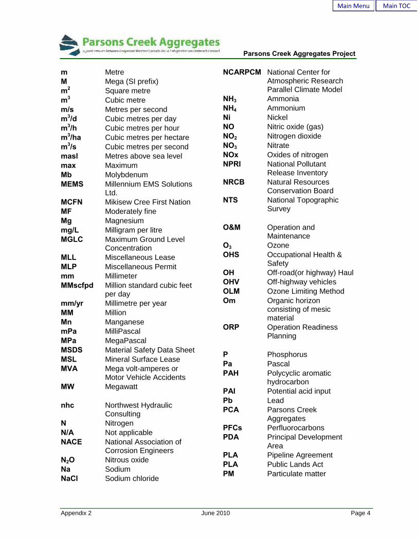
m MetreM Mega (SI prefix)m2 Square metrem3 Cubic metrem/s Metres per secondm3/d Cubic metres per daym3/h Cubic metres per hourm3/ha Cubic metres per hectarem3/s Cubic metres per secondmasl Metres above sea levelmax MaximumMb MolybdenumMEMS Millennium EMS Solutions
Ltd.MCFN Mikisew Cree First NationMF Moderately fineMg Magnesiummg/L Milligram per litreMGLC Maximum Ground Level
ConcentrationMLL Miscellaneous LeaseMLP Miscellaneous Permitmm MillimeterMMscfpd Million standard cubic feet
per daymm/yr Millimetre per yearMM MillionMn ManganesemPa MilliPascalMPa MegaPascalMSDS Material Safety Data SheetMSL Mineral Surface LeaseMVA Mega volt-amperes or
Motor Vehicle AccidentsMW Megawatt
nhc Northwest HydraulicConsulting
N NitrogenN/A Not applicableNACE National Association of
Corrosion EngineersN2O Nitrous oxideNa SodiumNaCl Sodium chloride
NCARPCM National Center forAtmospheric ResearchParallel Climate Model
NH3 AmmoniaNH4 AmmoniumNi NickelNO Nitric oxide (gas)NO2 Nitrogen dioxideNO3 NitrateNOx Oxides of nitrogenNPRI National Pollutant
Release InventoryNRCB Natural Resources
Conservation BoardNTS National Topographic
Survey
O&M Operation andMaintenance
O3 OzoneOHS Occupational Health &
SafetyOH Off-road(or highway) HaulOHV Off-highway vehiclesOLM Ozone Limiting MethodOm Organic horizon
consisting of mesicmaterial
ORP Operation ReadinessPlanning
P PhosphorusPa PascalPAH Polycyclic aromatic
hydrocarbonPAI Potential acid inputPb LeadPCA Parsons Creek
AggregatesPFCs PerfluorocarbonsPDA Principal Development
AreaPLA Pipeline AgreementPLA Public Lands ActPM Particulate matter
Parsons Creek Aggregates Project
Appendix 2 June 2010 Page 5
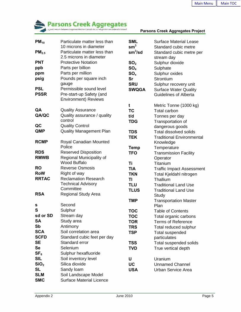
PM10 Particulate matter less than10 microns in diameter
PM2.5 Particulate matter less than2.5 microns in diameter
PNT Protective Notationppb Parts per billionppm Parts per millionpsig Pounds per square inch
gaugePSL Permissible sound levelPSSR Pre-start-up Safety (and
Environment) Reviews
QA Quality AssuranceQA/QC Quality assurance / quality
controlQC Quality ControlQMP Quality Management Plan
RCMP Royal Canadian MountedPolice
RDS Reserved DispositionRMWB Regional Municipality of
Wood BuffaloRO Reverse OsmosisRoW Right of wayRRTAC Reclamation Research
Technical AdvisoryCommittee
RSA Regional Study Area
s SecondS Sulphursd or SD Stream daySA Study areaSb AntimonySCA Soil correlation areaSCFD Standard cubic feet per daySE Standard errorSe SeleniumSF6 Sulphur hexafluorideSIL Soil inventory levelSiO2 Silica dioxideSL Sandy loamSLM Soil Landscape ModelSMC Surface Material Licence
SML Surface Material Leasesm3 Standard cubic metresm3/sd Standard cubic metre per
stream daySO2 Sulphur dioxideSO4 SulphateSOx Sulphur oxidesSr StrontiumSRU Sulphur recovery unitSWQGA Surface Water Quality
Guidelines of Alberta
t Metric Tonne (1000 kg)TC Total carbont/d Tonnes per dayTDG Transportation of
dangerous goodsTDS Total dissolved solidsTEK Traditional Environmental
KnowledgeTemp TemperatureTFO Transmission Facility
OperatorTi TitaniumTIA Traffic Impact AssessmentTKN Total Kjeldahl nitrogenTl ThalliumTLU Traditional Land UseTLUS Traditional Land Use
StudyTMP Transportation Master
PlanTOC Table of ContentsTOC Total organic carbonsTOR Terms of ReferenceTRS Total reduced sulphurTSP Total suspended
particulatesTSS Total suspended solidsTVD True vertical depth
U UraniumUC Unnamed ChannelUSA Urban Service Area

Parsons Creek Aggregates Project
Appendix 2 June 2010 Page 6
USEPA United StatesEnvironmental ProtectionAgency
UTM Universal TransverseMercator
UTZ Upper transition zoneUV Ultraviolet
V VanadiumVA Volt – AmpereVDC Volt DCVECs Valued environmental
componentsVOC Volatile organic compounds
WA Alberta Water ActWHMIS Workplace Hazardous
Materials InformationSystem
WSC Water Survey of CanadaWSW Water Source WellsWBEA Wood Buffalo
Environmental Association
Y or yr Year
Zn ZincZOI Zone of influenceZr Zirconium

Parsons Creek Aggregates Project
Appendix 2 June 2010 Page 7
GLOSSARY OF TERMS
Acidification The decrease of acid neutralizing capacity in water, or basesaturation in soil, caused by natural or anthropogenic processes.Acidification is exhibited as the lowering of pH, which canadversely affect aquatic life (Brönmark and Hansson 1998).
Admixing The dilution of topsoil with subsoil, spoil or waste material, withthe result that topsoil quality is reduced (AENV 2002).
Adverse Effect Impairment of or damage to the environment, human health orsafety or property (Province of Alberta 2003).
Airshed Describes the geographic area requiring unified management forachieving air pollution control.
Alkalinity (1) The quality or state of being alkaline; the concentration of OH-
ions. (2) A measure of the ability of water to neutralize acids. It ismeasured by determining the amount of acid required to lower thepH of water to 4.5. In natural waters, the alkalinity is effectivelythe bicarbonate ion concentration plus twice the carbonate ionconcentration, expressed as milligrams per liter calciumcarbonate (Canadian Society of Soil Science 2001).
Alluvium(Alluvial Deposit)
Material such as clay, silt, sand and gravel deposited by modernrivers and streams (AENV 2002).
Ambient The conditions surrounding an organism or area.
Ambient Air The air in the surrounding area.
Ambient SoundLevel
All noises that exist in an area and are not related to a facilitycovered by Energy Resources Conservation Board Directive 038.Ambient noise includes sound from other industrial noise notsubject to this directive, transportation sources, animals andnature.
Ambient Noise The noise in the environment, other than the noise from thesource of interest.
Amendment (Soil) (1) An alteration of the properties of a soil, and thereby of the soil,by the addition of substances such as lime, gypsum, manure, andsawdust to make the soil more suitable for the growth of plants.(2) Any substance used for this purpose. Technically, a fertilizer isalso an amendment but the term “amendment” is used mostcommonly for added materials other than fertilizer (AENV 2002).

Parsons Creek Aggregates Project
Appendix 2 June 2010 Page 8
Angle of Repose Angle between the horizontal and the maximum inclination (slope)that soil and overburden materials or rock fragments and sandparticles assume through natural processes.
Anion An ion carrying a negative charge of electricity (AENV 2002).
Anthropogenic Coming from or having been caused by man.
Aquifer An underground water-bearing formation that is capable ofyielding water (Province of Alberta 2000).
Aquatic Growing, living in or frequenting water; occurring or situated in oron water (AENV 2002).
Aquatic Biota Organisms that live in or frequent water (AENV 2002).
AquaticEcosystems
(1) The biological community and the non-living environmentfunctioning together as a system in water bodies. (2) Aquatichabitat for interrelated and interacting communities andpopulations of plants and animals (AENV 2002).
Archaeology The scientific discipline responsible for studying the unwrittenportion of man’s historic and prehistoric past.
Armouring Channel erosion protection by covering with protection material(e.g., rip rap, gabions, etc); (AENV 2002).
AtmosphericAttenuation
The effect of sound absorption by moisture in the air.
Attenuation A reduction in the amplitude or energy of a signal, such as mightbe produced by passage through a filter (Canadian Society of SoilScience 2001).
A-Weighted SoundLevel
A measurement of overall Sound Pressure Level which accountsfor the frequency content of the measured sound and assesses itwith a frequency response similar to that of the human ear.
Backfill (1) The operation of refilling an excavation. (2) The materialplaced in an excavation in the process of backfilling (AENV 2002).
Background An area not influenced by chemicals released from the site underevaluation or other impacts created by the activity on the siteunder evaluation (AENV 2002).
BackgroundConcentration(Environmental)
The concentration of a chemical in a defined control area during afixed period before, during or after data gathering (AENV 2002).

Parsons Creek Aggregates Project
Appendix 2 June 2010 Page 9
Background Noise The noise in the environment, other than the noise from thesource of interest.
Background SoundLevel
All noises that exist in an area including existing facilities coveredby Alberta Energy and Utilities Board Directive 038. Backgroundnoise includes sound from other industrial noise not subject to thisdirective, transportation sources, animals and nature.
Backwater Discrete, localized area and exhibiting reverse flow direction andgenerally lower stream velocity than main current. Substratesimilar to adjacent channel with more fines.
Baghouse Dust collection technology using central vacuum system andenclosure with individual fabric bags or cartridge filters
Barrier Diffraction The effect of an acoustical shadow created by building orlandform interposed between a source and a receiver.
Baseline A surveyed condition that serves as a reference point on whichlater surveys are coordinated or correlated (Beanlands andDuinker 1983). The baseline scenario includes existingenvironmental conditions, existing and approved projects oractivities (EIA Terms of Reference).
Basic NighttimeSound Level (BSL)
The A weighted Leq sound level commonly observed to occur inthe designated land-use categories with industrial presence (EUBDirective Glossary). The BSL in the initial building block fromwhich the PSL is determined.
Bathymetry The measurement of water depth at various places in a body ofwater; also: the information derived from such measurements.
Bedrock The solid rock that underlies soil and the regolith or that isexposed at the surface (AENV 2002).
BenthicInvertebrates
Invertebrate organisms living at, in or in association with thebottom (benthic) substrate of lakes, ponds and streams.Examples of benthic invertebrates include aquatic insect species(such as caddisfly larvae) that spend at least part of their life-stages dwelling on bottom sediments in the rivers and lakes.Many benthic invertebrates are major food sources for fish (AENV1990).

Parsons Creek Aggregates Project
Appendix 2 June 2010 Page 10
Benzene The simplest aromatic hydrocarbon; formula C6H6. The benzenemolecule is a closed ring of six carbon atoms connected by bondsthat resonate between single and double bonds. Benzene and itsderivatives are known as aromatic compounds. The liquid isvolatile, insoluble in water but miscible in all proportions withorganic solvents. Benzene has a long history of use in thechemical industry as a solvent and as a starting compound for thesynthesis of a variety of other materials, and is now also usedextensively in the rubber, paint, and plastic industries. The liquidis volatile and emissions are regulated as a toxic air pollutant(Canadian Society of Soil Science 2001).
Berm A linear mound or wall of overburden materials used to retainsubstances or to prevent substances from entering an area.
Biodiversity Totally of the richness of biological variation, ranging from within-species genetic variation, through subspecies and species, tocommunities, and the pattern and dynamics of these on thelandscape (AENV 2002).
BiologicalIndicators
Any biological parameter used to indicate the response ofindividuals, populations or ecosystems to environmental stress(AENV 2002).
Biomass The weight of all living material in a unit area or volume at a giveninstant in time and can be expressed at different biological levels(e.g., population, community) (AENV 2002).
Biome A major community of plants and animals such as the borealforest or the tundra biome (AENV 2002).
Biotic The living organisms in an ecosystem.
BOD The measure or quantity of oxygen used in aquatic environmentsfor the biochemical oxidation of organic matter under specifiedconditions. An indirect measure of biologically degradableorganic material (Canadian Society of Soil Science 2001).
Bottom Sediments Those sediments that make up the bed of a body of running orstill water (AENV 2002).
Buffer (1) An area designated to be undisturbed by an industrial activity.Buffers may preserve environmental features (e.g., river banks),provide safety (e.g., beside pipelines or buildings) or protectproperty (e.g., roads, property lines). (2) A transitional areabetween two different land uses that mitigates the effect of oneland use on the other (AENV 2002)

Parsons Creek Aggregates Project
Appendix 2 June 2010 Page 11
Calcination The process of heating a substance to a high temperature butbelow the melting or fusing point, causing loss of moisture,reduction or oxidation, and dissociation into simpler substances.The term was originally applied to the method of driving off carbondioxide from limestone to obtain lime (calcium oxide).
CALPUFF California Puff model, used to estimate ambient concentrations ofsubstances in air, and deposition of those substances (e.g., aciddeposition).
Calmet California Meteorological Model. Used to process meteorologicaldata for input into the CALPUFF model.
CO2e CO2 equivalents. An expression of the total amount ofgreenhouse gases in the air, taking into account their relativecontributions to global warming and climate change, as if allsubstances were CO2.
CWQG Canadian Water Quality Guidelines. Numerical concentrations ornarrative statements recommended to support and maintain adesignated water use in Canada. The guidelines containrecommendations for chemical, physical, radiological andbiological parameters necessary to protect and enhancedesignated uses of water.
Calibration Comparison of a measurement standard or instrument withanother standard or instrument in order to report or eliminate byadjustment any variation (deviation) in the accuracy of the itembeing compared (AENV 2002).
Candela Unit describing the intensity of a light source in a specifieddirection (intensity), equal to one lumen per steradian.
Canopy The tallest vegetation layer in an area. Overhanging cover,shelter or shade (AENV 2002).
Carcinogen An agent that is reactive or toxic enough to act directly to causecancer.
Carrying Capacity The maximum population size that can be supported by theavailable resources (AENV 2002).
Cervid Of the family Cervidae, which includes elk, deer, moose andcaribou.
Check Dam Small dam constructed in a gully or other small watercourse todecrease the stream flow velocity, minimize channel scour, andpromote deposition of sediment (AENV 2002).
Parsons Creek Aggregates Project
Appendix 2 June 2010 Page 12
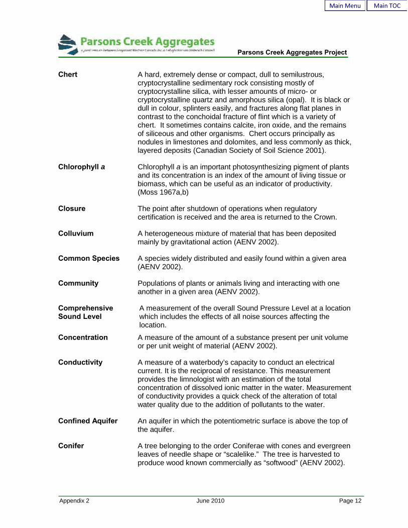
Chert A hard, extremely dense or compact, dull to semilustrous,cryptocrystalline sedimentary rock consisting mostly ofcryptocrystalline silica, with lesser amounts of micro- orcryptocrystalline quartz and amorphous silica (opal). It is black ordull in colour, splinters easily, and fractures along flat planes incontrast to the conchoidal fracture of flint which is a variety ofchert. It sometimes contains calcite, iron oxide, and the remainsof siliceous and other organisms. Chert occurs principally asnodules in limestones and dolomites, and less commonly as thick,layered deposits (Canadian Society of Soil Science 2001).
Chlorophyll a Chlorophyll a is an important photosynthesizing pigment of plantsand its concentration is an index of the amount of living tissue orbiomass, which can be useful as an indicator of productivity.(Moss 1967a,b)
Closure The point after shutdown of operations when regulatorycertification is received and the area is returned to the Crown.
Colluvium A heterogeneous mixture of material that has been depositedmainly by gravitational action (AENV 2002).
Common Species A species widely distributed and easily found within a given area(AENV 2002).
Community Populations of plants or animals living and interacting with oneanother in a given area (AENV 2002).
ComprehensiveSound Level
A measurement of the overall Sound Pressure Level at a locationwhich includes the effects of all noise sources affecting thelocation.
Concentration A measure of the amount of a substance present per unit volumeor per unit weight of material (AENV 2002).
Conductivity A measure of a waterbody’s capacity to conduct an electricalcurrent. It is the reciprocal of resistance. This measurementprovides the limnologist with an estimation of the totalconcentration of dissolved ionic matter in the water. Measurementof conductivity provides a quick check of the alteration of totalwater quality due to the addition of pollutants to the water.
Confined Aquifer An aquifer in which the potentiometric surface is above the top ofthe aquifer.
Conifer A tree belonging to the order Coniferae with cones and evergreenleaves of needle shape or “scalelike.” The tree is harvested toproduce wood known commercially as “softwood” (AENV 2002).

Parsons Creek Aggregates Project
Appendix 2 June 2010 Page 13
ConservativeApproach
Approach taken to incorporate protective assumptions to ensurethat risk will not be underestimated (AENV 2002).
Containment Technologies that reduce the mobility of a contaminant plume inthe subsurface via construction of physical barriers. Also used inreducing the flow of water through contaminated media (AENV2002).
Consolidation The gradual reduction in volume of a soil or semi-solid massresulting from an increase in compressive stress. The adjustmentof a saturated soil in response to increasing load involves thesqueezing of water from pores and a decrease in the void ratio(AENV 2002).
Contaminant A general term referring to any chemical compound added to areceiving environment in excess of natural concentrations. Theterm includes chemicals or effects not generally regarded as“toxic,” such as nutrients, colour and salts (AENV 2002).
Contouring The process of shaping the land surface to fit the form of thesurrounding land (AENV 2002).
Control An area that is undisturbed or unaffected by an activity andtherefore can serve as a comparison to assess the state of anarea that has been disturbed or affected by an activity. Also knowas a reference area. Area control sites are located further awaythan local control sites (AENV 2002).
Conveyor An electric-powered mechanical belt and roller apparatus used formoving either rock fragments or aggregates from station to stationin a typical aggregate plant for crushing and screening.
Conveyor (Stacker) An electric-powered mechanical belt and roller apparatusequipped with variable height settings for use in creatingstockpiles of rock fragments or aggregate products, usually asfinal output or conveyed from the aggregate plant.
Cover The area of ground covered by all living (including stems andleaves) and dead (litter) plant material that is produced naturallyon a site, expressed as a percentage of the total area. Bare soilis not cover. Also known as ground cover, canopy cover or aerialcover (AENV 2002).
Creel Survey A survey of sport fishing activity to identify factors such as thenumber of anglers, number and species of fish caught, resident offishermen, etc. (Nelson and Paetz 1992).

Parsons Creek Aggregates Project
Appendix 2 June 2010 Page 14
Criteria A maximum and/or minimum value for a physical, chemical orbiological characteristic of water, sediment or biota, which shouldnot be exceeded to prevent specified detrimental effects fromoccurring to a water use including aquatic life under specifiedenvironmental condition (AASWQ Interim Guidelines and AAAQGuidelines).
Crusher Aggregate processing equipment, jaw, cone or roll shaped, thatapply a compressive force to rock and rock fragments trappedbetween crushing surfaces to produce different aggregate sizes.
Cumulative Effects Individual impacts that are incremental and additive such that theymust be considered collectively and over time, in order for a truemeasure of the impact and associated environmental costs of anactivity to be assessed (CEAA 1994).
Cut-and-fill Process of earth moving by excavating part of an area and usingthe excavated material for adjacent embankments or fill areas(AENV 2002).
Cutblock A specified area of merchantable timber with defined boundariesdesignated for harvest (AENV 2002).
dB (decibel) A unit of measure of sound pressure that compresses a largerange of numbers into a more meaningful scale.
DBA The decibel (dB) sound pressure level filtered through the Afiltering network to approximate human hearing response.
See dB and A-weighted sound level.
dBA A measurement of overall Sound Pressure Level which accountsfor the frequency content of the measured sound and assesses itwith a frequency response similar to that of the human ear.
Daytime Defined as the hours from 07:00 to 22:00.
Daytimeadjustment
An adjustment that allows a 10 dBA increase above the basicsound level for nighttime, as daytime sound levels are generallyabout 10 dBA higher than nighttime values.
Decommissioning The permanent closure of all or part of an industrial facilityfollowed by removal of process equipment, buildings and otherstructures, and the decontamination of the surface andsubsurface (AENV 2002).
Parsons Creek Aggregates Project
Appendix 2 June 2010 Page 15
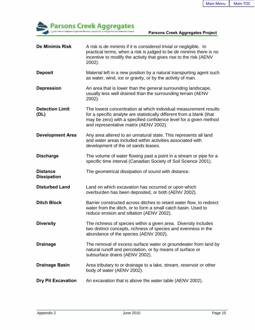
De Minimis Risk A risk is de minimis if it is considered trivial or negligible. Inpractical terms, when a risk is judged to be de minimis there is noincentive to modify the activity that gives rise to the risk (AENV2002).
Deposit Material left in a new position by a natural transporting agent suchas water, wind, ice or gravity, or by the activity of man.
Depression An area that is lower than the general surrounding landscape,usually less well drained than the surrounding terrain (AENV2002).
Detection Limit(DL)
The lowest concentration at which individual measurement resultsfor a specific analyte are statistically different from a blank (thatmay be zero) with a specified confidence level for a given methodand representative matrix (AENV 2002).
Development Area Any area altered to an unnatural state. This represents all landand water areas included within activities associated withdevelopment of the oil sands leases.
Discharge The volume of water flowing past a point in a stream or pipe for aspecific time interval (Canadian Society of Soil Science 2001).
DistanceDissipation
The geometrical dissipation of sound with distance.
Disturbed Land Land on which excavation has occurred or upon whichoverburden has been deposited, or both (AENV 2002).
Ditch Block Barrier constructed across ditches to retard water flow, to redirectwater from the ditch, or to form a small catch basin. Used toreduce erosion and siltation (AENV 2002).
Diversity The richness of species within a given area. Diversity includestwo distinct concepts, richness of species and evenness in theabundance of the species (AENV 2002).
Drainage The removal of excess surface water or groundwater from land bynatural runoff and percolation, or by means of surface orsubsurface drains (AENV 2002).
Drainage Basin Area tributary to or drainage to a lake, stream, reservoir or otherbody of water (AENV 2002).
Dry Pit Excavation An excavation that is above the water table (AENV 2002).

Parsons Creek Aggregates Project
Appendix 2 June 2010 Page 16
EA Environmental Assessment. A review of the effects that aproposed development will have on the local and regionalenvironment. For the purposes of this report, EA refers toassessment of impacts to aquatic resources (Beanlands andDuinker 1983).
Ecosystem A complex of living organisms and their environment, linked byenergy flows and material cycling. An ecological communityconsidered together with the nonliving factors of its environmentas a unit (AENV 2002).
Edaphic (1) Of or pertaining to the soil. (2) Resulting from, or influencedby, factors inherent in the soil or other substrate rather than byclimatic factors (AENV 2002).
Edge Where plant communities meet (often an area of highbiodiversity); and where plant communities meet a disturbance(AENV 2002).
Efficacy The quotient of total luminous flux emitted by the source, dividedby the total power input to create such.
Effluent The discharge or outflow of water from ground or subsurfacestorage (Canadian Society of Soil Science 2001).
Emergent Aquatic vascular plants that grow with the considerable portion ofits vegetation above water.
EndangeredSpecies
A species facing imminent extirpation or extinction (AENV 2002).
End Land Use The allowable use or uses of disturbed land following reclamation.Municipal approval or land use re-designation may be required forspecific land uses (AENV 2002).
End Pit Lake A water body greater than 2 metres deep which has been createdas a result of mining/extraction activities (AENV 2002).
Energy equivalentsound level (Leq)
The Leq is a single-number average, A-weighted sound level thatrepresents cumulative acoustical energy as measured over aspecified time interval. This interval should be specified inbrackets following the Leq (e.g.: Leq (9) is a nine-hour Leq).
Entrainment Voluntary or involuntary entrapment of aquatic organisms and fishwithin a volume of water (i.e., pumped water). (DFO 1995)
EnvironmentalImpact Assessment
A review of the effects that a proposed development will have onthe local and regional environment.
Parsons Creek Aggregates Project
Appendix 2 June 2010 Page 17
EnvironmentalManagementSystem
An environmental management program/process or assessmentprocedure developed by an operator to assess andmitigate/address risks to the environment arising from anindustrial activity, operation, goods or services. An EMSpromotes ongoing improvement of operations. An EMS iscomprised of elements such as policy development, standardoperating procedures, training, auditing, reporting/documenthandling, monitoring and public involvement (AENV 2002).
Ephemeral A phenomenon or feature that last only a short time (i.e., anephemeral stream is only present for short periods during theyear); (AENV 2002).
EquivalentContinuous SoundLevel or Leq
A single number descriptor commonly used for environmentalnoise measurements and criteria. It is used to quantify soundwhich constantly varies over time, such as that commonlyoccurring in outdoor environments. It is defined as the averageSound Pressure Level over a specific time period that has thesame acoustic energy as the actual fluctuating Sound PressureLevels during the same time period. Time periods commonlyused for Leq measurements and criteria are the daytime (07:00 –22:00 hrs) and nighttime (22:00 – 07:00 hrs) periods.
Equivalent LandCapability
The ability of the land to support various land uses afterreclamation is similar to the ability that existed prior to any activitybeing conducted on the land, but the ability to support individualland uses will not necessarily be equal after reclamation(Regulatory definition); (AENV 2002).
Erosion The wearing away of the land surface by running water, wind, ice,other geological agents, activities of man or animals, andincluding such processes as gravitational creep. Erosion may beeither normal or accelerated; the latter being brought about bychanges in the natural cover or ground conditions, including thosedue to human activity (AENV 2002).
Evaporation The process in which a liquid is changed into a gas by moleculartransfer (Canadian Society of Soil Science 2001).
Evapotranspiration The loss of water from a given area during a specified time byevaporation from the soil surface and transpiration from the plants(Canadian Society of Soil Science 2001).
Excavation Cutting or digging of the earth’s surface which alters the originallandscape by making a hole or hollow (pit); (AENV 2002).

Parsons Creek Aggregates Project
Appendix 2 June 2010 Page 18
Exposure Contact between a substance and an individual or population. Itmay occur via different pathways including oral, dermal andinhalation (AENV 2002).
Exposure Pathway The route by which an organism comes into contact with acontaminant. In the ecological effects-based procedure, exposurepathways are restricted to organisms that come in contact throughconsumption of contaminated food, direct soil ingestion and dustinhalation (AENV 2002).
Extinct Species A species that no longer exists (AENV 2002).
Extirpated Species A species that no longer exists in the wild in Canada, but occurselsewhere (AENV 2002).
Extraction Digging up and removing resources that are used for specificpurposes (AENV 2002).
Facility Any operation used in exploration, processing, development andtransportation of energy resources.
Fauna The animals in a particular region or geologic period (CanadianSociety of Soil Science 2001).
Fill Depth of which material is to be placed (filled) to bring the surfaceto a predetermined grade. Also, the material itself (AENV 2002).
Filterable Residue Materials in water that pass through a standard-size filter (often0.45 µm). This is a measure of the “total dissolved solids” (TDS),i.e., chemicals that are dissolved in the water or that are in aparticulate form smaller than the filter size. These chemicals areusually salts, such as sodium ions and potassium ions (AENV2002).
Fish Habitat Section 34 of the Fisheries Act, “any spawning grounds andnursery, rearing and food supply and migration areas on whichfish depend, directly or indirectly, in order to carry out their lifeprocess” (DFO regulatory definition 1985).
Fish Impingement Generally the physical entrapment of a fish on an object (e.g., ascreen) cause by water velocity from which the fish cannotescape. (DFO 1995)
Fish Tissue Generally referred to as the muscle or edible portions of a fish(i.e., muscle tissue) or the organs (i.e., liver tissue).

Parsons Creek Aggregates Project
Appendix 2 June 2010 Page 19
Fisheries Act Federal legislation that protects fish habitat from being altered,disrupted or destroyed by chemical, physical or biological means.Destruction of the habitat could potentially undermine theeconomic, employment and other benefits that flow fromCanada’s fisheries resources (DFO regulatory definition 1985).
Floodplain The land bordering a stream, built up of sediments from overflowof the stream and subject to flooding. The lowland which bordersa river, usually dry but subject to flooding. Also the portion of ariver valley which has been inundated by the river during historicfloods (Canadian Society of Soil Science 2001).
Fluvial (Deposit) Material that has been transported and deposited by streams andrivers (AENV 2002).
Forage Area The area used by an organism for hunting or gathering food(AENV 2002).
Forage Fish Small fish that provide food for larger fish (e.g., pearl dace,fathead minnow).
Forb An herbaceous plant which is not a grass, sedge, or rush (AENV2002).
Forest A continuous tract of trees over a large area; land with at least10% of its surface area stocked by trees of any size. One of thefour main subdivisions of world vegetation (Canadian Society ofSoil Science 2001).
ForestFragmentation
The change in the forest landscape, from extensive andcontinuous forests.
Fork Length Distance from the proximal tip of the head to the tip of the middleray of the caudal fin of a fish. (Nelson and Paetz 1992)
Fragmentation The process of reducing the size and/or connectivity of anecosystem or habitat type (AENV 2002).
Freeboard Vertical distance between the maximum water surface elevationanticipated in design and the top of retaining banks or structuresprovided to prevent overtopping because of unforeseenconditions (AENV 2002).
Frequency The number of wave oscillations per second (hertz) of an acousticpressure wave propagating through the air. The same as thepitch, or highness or lowness of a sound.

Parsons Creek Aggregates Project
Appendix 2 June 2010 Page 20
Fry Young fish, newly hatched, after the yolk has been used up andactive feeding has commenced. (Nelson and Paetz 1992)
Fugitive Emissions Substances emitted from any source except those from stacksand vents. Typical sources include gaseous leakage from valves,flanges, drains, volatilization from ponds and lagoons, and opendoors and windows. Typical particulate sources include bulkstorage areas, open conveyors, construction areas or plant roads.
Genetic Diversity Variation among and within species that is attributable todifferences in hereditary material (Canadian Society of SoilScience 2001).
Gen-set Generic industry term for diesel generators used in producingelectric power for operating portable facilities such as aggregatecrushing and screening plants and water pumps.
Geomorphic Pertaining to natural evolution of surface soils and landscape overlong periods.
GeomorphicalProcesses
The origin and distribution of landforms, with the emphasis on thenature of erosional processes.
Geomorphology That branch of science that deals with the form of the earth, thegeneral configurations of its surface and the changes that takeplace in the evolution of landforms.
GIS Geographic Information System. Pertains to a type of computersoftware that is designed to develop, manage, analyze anddisplay spatially referenced data.
Glacial Till (Till) Unsorted and unstratified glacial drift (generally unconsolidated)deposited directly by a glacier without subsequent reworking bywater from the glacier. Consisting of a heterogeneous mixture ofclay, silt, sand, gravel and boulders (i.e., drift) varying widely insize and shape.
Glaciofluvial (orGlacio-fluvial)
Pertaining to the meltwater streams flowing from wasting glacierice and especially to the deposits and landforms produced bystreams; relating to the combined action of glaciers and streams(AENV 2002).
Glaciolacustrine (orGlacio-lacustrine)
Pertaining to, derived from or deposited by streams flowing fromthe melting ice. The deposits are stratified and may occur in theform of outwash plains, deltas, kames, eskers and kame terraces(Canadian Society of Soil Science 2001).

Parsons Creek Aggregates Project
Appendix 2 June 2010 Page 21
Glaciomarine (ofGlacio-marine)
Relating to process or deposits that involve the action of glaciersand the sea or the action of glaciers in the sear. Sediments ofglacial origin laid down from suspension in a marine environmentin close proximity to glacier ice (AENV 2002).
Grid Cell (Cell) A small, regular-shaped subregion of a numerical air qualitymodel.
Grizzly Feeder Aggregate processing equipment that uses one or more screensfor separating blasted rock fragments into various sizes for feedinto the primary crusher (jaw).
GroundAttenuation
The effect of sound absorption by the ground separating thesource and receiver.
Ground Cover Any living or dead vegetative material producing a protective maton or just above the soil surface (AENV 2002).
Groundtruthing (orGround Truthing)
Conducting site visits to confirm accuracy of remotely sensedinformation (AENV 2002).
Groundwater All water under the surface of the ground (Province of Alberta2003).
Groundwater Level The upper surface of groundwater or that level below which thesoil is saturated with water (Canadian Society of Soil Science2001).
GroundwaterRegime
Water below the land surface in a zone of saturation.
GroundwaterVelocity
The rate of water movement through openings in rock or sediment(Canadian Society of Soil Science 2001).
Grout Material injected into a soil or rock formation, usually cementbased, to change the physical characteristics of the formation(AENV 2002).
Grout Curtain Containment barriers formed by grout injection (AENV 2002).
Growing Season Period with soil temperatures over 5°C at a depth of 50 cm (AENV2002).
Grubbing The process of clearing stumps and roots from land (AENV 2002).
Habitat The natural environment of an organism (AENV 2002).

Parsons Creek Aggregates Project
Appendix 2 June 2010 Page 22
Habitat Alteration,Disruption orDestruction
Subsection 35(1) of the Fisheries Act is a general prohibition ofharmful alteration, disruption or destruction (HADD) of fish habitat.This means that any work or undertaking that results in HADD is acontravention of Subsection 35(1). The only relief from thisgeneral prohibition is when a Subsection 35(2) Authorization isissued for the HADD. It is important to note that this 35(2)Authorization authorizes the HADD and not the project resulting inthe HADD. The project does not need a 35(2) Authorization toproceed (DFO regulatory definition 2010).
HabitatFragmentation
Occurs when extensive, continuous tracts of habitat are reducedby habitat loss to dispersed and usually smaller patches ofhabitat. Generally reduces the total amount of available habitatand reduces remaining habitat into smaller, more isolatedpatches.
Habitat Suitability The relative potential of an area to support individuals orpopulations of a fish species.
Hardiness The ability to withstand severe climates, especially frost duringthe growing season (AENV 2002).
Haul Road (1) Road or roads used internally by OH trucks for transportingrock fragments from quarry open pit to limestone preparationplant site. (2) Road or roads used by contractor or customer haultrucks for transporting aggregate rock products from quarry loadout area to quarry access to municipal road network.
Hazard The potential for a substance or situation to cause harm, usuallyhuman illness or injury. The adverse impact on health that canresult from exposure to a substance. The significance of theadverse effect depends on the nature and severity of the hazardand the degree to which the effect is reversible. In some instancethe substance itself is also sometimes referred to as the hazard,rather than the adverse effect which the substance can cause(AENV 2002).
Head The upper part of an aquatic system such as the source of astream. The upper part of a catchment, the apex of a delta or theend of a lake opposite the outlet (Canadian Society of SoilScience 2001).
Herb Any flowering plant except those developing persistent woodybases and stems above ground (AENV 2002).
Highwall (1) The unexcavated face of exposed overburden and mineral in aquarry or surface mine. (2) The face or bank on the hillside of acontour strip-mining excavation.

Parsons Creek Aggregates Project
Appendix 2 June 2010 Page 23
HistoricalResources
Works of nature or by humans valued for their palaeontological,archaeological, prehistoric, historic, cultural, natural, scientific oraesthetic interest.
HydraulicConductivity
The rate at which water can pass through a soil material underunit gradient; it is the proportionality factor (K) in Darcy’s law asapplied to the viscous flow of water in soil. It depends on theintrinsic permeability of the medium (k) and the fluid properties(mass density r, viscosity h) and can be defined as K=kgr/h,where g is the gravitational acceleration (Canadian Society of SoilScience 2001).
Hydraulic Gradient A measure of the force of moving groundwater through soil orrock. It is measured as the rate of change in total head per unitdistance of flow in a given direction. Hydraulic gradient iscommonly shown as being dimensionless, since its units aremetres/meter (AENV 2002).
Hydraulic Head The energy per unit weight of water made up of the sum of thepressure potential (head), velocity potential (head), and elevationpotential (head). The velocity head is often negligible and takenas zero for subsurface flow. Hydraulic head is often referred to aswater potential (AENV 2002).
Hydraulic Structure Any structure designed to handle water in any way. This includesretention, conveyance, control, regulation and dissipation of theenergy of water.
Hydrogeology The science that deals with subsurface water and with relatedgeologic aspects of surface water (Canadian Society of SoilScience 2001).
ICP (Metals) Inductively Coupled Plasma (Atomic Emission Spectroscopy).This analytical method is an U.S. EPA designated method(Method 6010). The method determines elements within samplesof groundwater, aqueous samples, leachates, industrial wastes,soils, sludges, sediments and other solid wastes. Samples requirechemical digestion before analysis.
Illuminance The areal density of luminous flux incident at a point on thesurface, in lumens per square meter (lm/sm, or lux).
Impermability The condition of a rock, sediment, or soil that renders it incapableof transmitting fluids under pressure (AENV 2002).
Parsons Creek Aggregates Project
Appendix 2 June 2010 Page 24
Increase in SoundLevel
The perceived increase in loudness of a sound does notcorrespond directly to numerical increases in dBA values.Typically, an increase of less than 3 dBA is barely noticeable, anincrease of 5 dBA is noticeable, an increase of 10 dBA isperceived as a doubling in apparent loudness, and an increase of20 dBA is perceived as a four-fold increase in apparent loudness.
Infiltration Downward water movement into the soil (AENV 2002).
In Situ In the natural or original position. A measurement taken in thefield without removal of a sample to the laboratory (CanadianSociety of Soil Science 2001).
Inorganics (1) Not pertaining to or derived from plant or animal origins(organisms). (2) A chemical of mineral origin which does notcontain (with few expectations) carbon or carbon compounds(AENV 2002).
In-stream FlowNeeds
The assessment of the volume of water needed in watercoursesto maintain ecological integrity (AENV 2002).
Inversion An atmospheric condition when temperatures increase with heightabove the ground. During inversion conditions the vertical mixingof emissions are restricted.
Kiln An inclined and rotating cylindrical furnace, typically welded steel-plate and lined with fire bricks, in which solid materials are heatedat high temperatures while moving continuously. Cement kilnsare used for the pyroprocessing stage in manufacturing hydrauliccement, where calcium carbonate, through calcination, reacts withsilica-bearing minerals to form a mixture of calcium silicates.
Lacustrine Material deposited in lake water and later exposed (AENV 2002).
Land Capability The ability of the land to support a given land use, based on anevaluation of the physical, chemical and biological characteristicsof the land, including topography, drainage, hydrology, soils andvegetation (AENV 2002).
Landform The various shapes of the land surface resulting from a variety ofactions such as deposition or sedimentation (eskers, lacustrinebasins), erosion (gullies, canyons) and earth crust movements(mountains); (AENV 2002).

Parsons Creek Aggregates Project
Appendix 2 June 2010 Page 25
Landscape (1) All the natural features such as fields, hills, forests, water, etc.,which distinguish one part of the earth’s surface from anotherpart. (2) Usually that portion of land or territory which the eye cansee in a single view, including all its natural characteristics (AENV2002).
LandscapeDiversity
The size, shape and connectivity of different ecosystems across alarge area.
Leaching The removal of soil material in solution by the downward or lateralpercolation of water (Alberta Environment 2002).
Leq See Energy equivalent sound level.
Lethal Causing death by direct action.
Lime Calcium Oxide (CaO)
Limestone Calcium Carbonate (CaCO3)
LimestonePreparation Facility
A plant site set up for preparing blasted limestone rock fragmentsinto limestone aggregate rock products using a grizzly feeder, jawcrusher, cone crusher and vibratory screening decks that areinterconnected by conveyors and stockpiling by conveyor stacker.
Linear Corridor Roads, seismic lines, pipelines and electrical transmission lines,or other long, narrow disturbances.
Littoral Zone (1) Productive shallow-water zone of lakes, rivers or seas withlight penetration to the bottom; often occupied by rooted aquaticplants. (2) The bio-geographic zone between the high- and low-water marks (AENV 2002).
Loading Rates The amount of deposition, determined by technical analysis,above which there is a specific deleterious ecological effect on areceptor.
Lumen The luminous flux emitted from a luminaire with uniform luminousintensity (in candelas), within a unit solid angle (in steradian).
Luminaire A complete lighting unit, including lamp(s) and ballast(s), withassociated positioning/shielding.
Luminance Quotient of luminous flux and projected area of source light onsurface, expressed in candelas/sm.

Parsons Creek Aggregates Project
Appendix 2 June 2010 Page 26
Luminous Flux Luminous flux is a quantitative expression of the brilliance of asource of visible light (e.g., light), which is electromagnetic energywithin the wavelength range of approximately 390 nanometers(nm) to 770 nm. The standard unit of luminous flux is the lumen(lm).
m3/d Cubic metres per day. A measure of oil production or processingrate.
m3/s Cubic metres per second. The standard measure of water flow inrivers; i.e., the volume of water in cubic metres that passes agiven point in one second.
Macrophytes Emergent: Plants that are especially adapted to grow in shallowwater (<1.0 m) with most of their photosynthetic parts above thewater surface.Submergent: aquatic plants that grow in water between 1.0 m and4.5 m in depth.(Nelson and Paetz 1992)
Management/Mitigation
An activity aimed at avoiding, controlling or reducing the severityof adverse physical, biological and/or socioeconomic impacts of aproject activity. (CEAA 1994)
Mature Forest A forest greater than rotation age with moderate to high canopyclosure; a multi-layered, multi-species canopy dominated by largeoverstory trees; some with broken tops and other decay;numerous large snags and accumulations of downed woodydebris (AENV 2002).
Mature Stand A stand of trees for which the annual net rate of growth haspeaked. A stand that has reached rotation age or has a reducedgrowth rate. Such stands normally have large mature or over-mature trees, an abundance of large live trees with heart rot,numerous snags, stubs and high stumps, and an abundance oflarge downed woody debris (AENV 2002).
Media The physical form of the environmental sample under study (e.g.,soil, water, air).
MerchantableForest
A forest area with potential to be harvested for protection oflumber/timber or wood pulp (AENV 2002).
Mesic Organic materials at a stage of decomposition between that offibric and humic materials. Peat soil material with >10% and<40% rubbed fibres. Mesic material usually is classified in thevon Post scale of decomposition as class 5 or 6 (AENV 2002).
Parsons Creek Aggregates Project
Appendix 2 June 2010 Page 27
Microclimate A local climatic condition near the ground resulting frommodification of the general climate by local differences inelevation, exposure, or cover (AENV 2002).
Microrelief Small-scale, local differences in relief, including mounds, swales,or hollows (AENV 2002).
Mineral Soil A soil consisting predominantly of, and having its propertiesdetermined predominantly by, mineral matter. It contains lessthan 17% organic carbon except for an organic surface layer thatmay be up to 40 cm (16 inches) thick if formed of mixed peat (bulkdensity 0.1 or more) or 60 cm (24 inches) if formed of fibric mosspeat (bulk density less than 0.1) (AENV 2002).
Minnows Small bodied fish, often referred to as forage fish (e.g.sticklebacks, fathead minnow).
Mitigation (1) The process of rectifying an impact by repairing, rehabilitatingor restoring the affected environment, or the process ofcompensating for the impact by replacing or providing substituteresources or environments. (2) Actions that lessen the severityand or duration of the effects on the environment (AENV 2002).
Mixedwood Stands Stands containing both deciduous and coniferous species.
Mixing Height The depth of surface layer in which atmospheric mixing ofemissions occurs.
Model Domain The region of interest for a numerical model.
Modeling Development of a mathematical or physical representation of atheory, event, object, process or system that accounts for all orsome other known properties. Models are often used to test theextent of changes of components on the overall performance ofthe system (Canadian Society of Soil Science 2001).
Movement Corridor Travel way used by wildlife for daily, seasonal, annual and/ordispersal movements from one area or habitat to another.
MultilayeredCanopy
Forest stands with two or more distinct tree layers in the canopy;also called multistoried canopy (AENV 2002).
Muskeg A North American term frequently employed for peatland. Theword is of Algonquin Indian origin and is applied in ordinaryspeech to natural and undisturbed areas covered more or lesswith Sphagnum mosses, tussocky sedges, and an open growth ofscrubby trees (AENV 2002).

Parsons Creek Aggregates Project
Appendix 2 June 2010 Page 28
Native Species A species that is a part of an area's original fauna or flora (AENV2002).
Narrow-Band A segment of the frequency spectrum which spans a few hertz ortenths of hertz.
Narrow-BandSound PressureLevel
The total Sound Pressure Level of sound components in aspecific narrow-band frequency segment. Narrow-band SoundPressure Levels are used to identify the presence of tonalcomponents in a sound.
Natural seeding(volunteer)
Natural distribution of seed over an area (AENV 2002).
Nighttime Defined as the hours from 22:00 to 07:00.
Noise The variance after the effects of the known variables have beenaccounted for. Any unexplained variance exhibiting nodiscernible pattern in terms of any other variable, or in space andtime is called random noise. Unexplained spatial variance iscalled spatial noise (Canadian Society of Soil Science 2001).
Noise ImpactAssessment (NIA)
Identifies the expected sound level emanating from a facility asmeasured 15 m from the nearest or most impacted permanentlyor seasonally occupied dwelling. It also identifies what thepermissible sound level is and how it was calculated.
Non-FilterableResidue
Material in a water sample that does not pass through a standardsize filter (often 0.45 mm). This is considered to represent “totalsuspended solids” (TSS), i.e., particulate matter suspended in thewater column (AENV 2002).
Non-sport fish Large bodied fish, not generally caught or consumed as sport orcommercial food fish (e.g., sucker species).
Noxious Weed A designation in Alberta for weeds that have the ability to spreadrapidly and cause severe crop losses and economic hardship(AENV 2002).
Nuisance Weed A designation in Alberta for weeds that are common to theProvince. In many cases they are native species. They can befound on nearly all land throughout the Province and as such arevery difficult to eradicate (AENV 2002).
Nutrients A chemical that is an essential raw material for the growth anddevelopment of organisms (AENV 2002).

Parsons Creek Aggregates Project
Appendix 2 June 2010 Page 29
Octave The interval in frequency between two sounds having a frequencyratio of two.
Octave Band A segment of the frequency spectrum which spans one octave.
Octave BandSound PressureLevel
The total sound pressure level of sound components in a specificoctave band.
1/3 Octave The 1/3 octave band analysis provides a finer breakdown ofsound distribution as a function of frequency.
Oil Sands (1) Sand and other rock materials containing crude bitumen.(2) The crude bitumen contained in those sands and other rockmaterials.(3) Any other mineral substances, other than natural gas, inassociation with that crude bitumen or those sands and other rockmaterials referred to in (1) and (2); (Province of Alberta 2003).
Organic Soil A soil composed predominantly of organic matter in contrast to amineral soil (Canadian Society of Soil Science 2001).
Organics Chemical compounds, naturally occurring or otherwise, whichcontain carbon, with the exception of carbon dioxide (CO2) andcarbonates (e.g., CaCO3).
Overburden Materials of any nature, consolidated or unconsolidated, thatoverlie a deposit of useful materials (AENV 2002).
Overstory A species, most often trees, that occurs within the tallestvegetation layer within a plant community (AENV 2002).
OverwinteringHabitat
Habitat used during the winter as a refuge and for feeding (AENV2002).
Parent Material The unconsolidated and more or less chemically weatheredmineral or organic matter from which the solum of a soil isdeveloped by pedogenic processes (AENV 2002).
Peat A material composed almost entirely of organic matter from thepartial decomposition of plants growing in wet conditions(Province of Alberta 2002).
Peatland A generic term including all types of peat-covered terrain (AENV2002).

Parsons Creek Aggregates Project
Appendix 2 June 2010 Page 30
Percolation (1) The downward flow of water in saturated or nearly saturatedsoil. (2) Movement of water under hydrostatic pressure or gravitythrough the interstices of rock, soil, or wastes. Typically a deepmovement into subsurface aquifers (AENV 2002).
Periphyton Periphyton refers to the community of algae, bacteria, fungi, andtheir secretions that grow on substrates in freshwater systems.Periphyton provides food and habitat resources for benthicinvertebrates and food for herbivorous fish, especially in flowingwaters. (Smith and Smith 2001)
Permissible SoundLevel (PSL)
The maximum sound level that a facility should not exceed at apoint 15m from the nearest or most impacted dwelling unit.
Permit Holder The director of a Historical Resource Impact Assessment.Responsible for the satisfactory completion of all field andlaboratory work and author of the technical report.
pH The negative logarithm of hydrogen ion concentration. The pHscale is generally presented from 1 (most acidic) to 14 (mostalkaline). A difference of one pH unit represents a ten-foldchange in hydrogen ion concentration.
Phaeophytin a Degradation product of chlorophyll a, its concentration is an indexof the amount of dead or dying plant tissue.
Physiological Related to function in cells, organs or entire organisms, inaccordance with natural processes of life.
Piezometer An instrument for measuring pressure head in a conduit, tank,soil, etc. It usually consists of a small pipe or tube tapped into theside of the container, connected with a manometer pressuregage, mercury or water column, or other device for indicatingpressure head (AENV 2002).
PiezometricSurface
Mapped and contoured water level elevations of an aquifer. Alsoknown as a potentiometric surface (AENV 2002).
Pioneer Species Plant species that initially invade a newly exposed surface (AENV2002).
Plant Community An association of plants of various species found growingtogether.
Pool Habitat Area of the stream channel featuring increased depth andreduced velocity relative to riffle and run habitat types.

Parsons Creek Aggregates Project
Appendix 2 June 2010 Page 31
Population All individuals of a species living in defined geographical area atthe same time in association with each other (Canadian Society ofSoil Science 2001).
Pore Water Water between the grains of rock or soil (AENV 2002).
Porosity The volume percentage of the total bulk not occupied by solidparticles. The ratio of volume of voids in a soil mass to the totalvolume of the mass (AENV 2002).
Profile A vertical section of the soil through all its horizons and extendinginto the parent material (AENV 2002).
ProgressiveReclamation
Any interim or concurrent reclamation of disturbed landundertaken during, following or in connection with construction,development and ongoing activities or operations associated withan active disposition (AENV 2002).
Project Parsons Creek Aggregates Limestone Quarry Project
Quarry Any opening in, excavation in, or working of the surface orsubsurface for the purpose of working, recovering, opening up orproving ammonite shell or any mineral other than coal, a coalbearing substance, oil sands, or an oil sands bearing substance,and includes any associated infrastructure (Regulatory definition);(AENV 2002).
Quicklime Calcium oxide (CaO). Commonly used in emission controlsystems to remove sulphur dioxide(SO2) and sulphurtrioxide(SO3); also used in water purification systems to removeinorganic impurities.
Reach A specified length of a stream or channel (Canadian Society ofSoil Science 2001).
Rearing Habitat Habitat used by young for feeding and/or as refuge frompredators (AENV 2002).
Receptor The person or organism subjected to exposure to chemicals orphysical agents (AENV 2002).
Recharge/Discharge Area
Recharge/Discharge Area are areas that either contribute(recharge) or take away (discharge) to/from the overall volume ofgroundwater in an aquifer.

Parsons Creek Aggregates Project
Appendix 2 June 2010 Page 32
Reclamation Any or all of the following:
(i) the removal of equipment or buildings or other structuresor appurtenances;
(ii) the decontamination of buildings or other structures orother appurtenances, or land or water;
(iii) the stabilization, contouring, maintenance, conditioning orreconstruction of the surface of land;
(iv) any other procedure, operation or requirement specified inthe regulations (Province of Alberta 2003).
ReclamationCertificate
A document issued by a designated Inspector (ASRD or ASRD)under EPEA, signifying that the conservation and reclamationterms and conditions issued under an EPEA approval or PublicLands Act disposition have been complied with.
Reclamation Unit A unique combination of reclamation conditions, namely surfaceshape, sub-base material, cover material and initial vegetation.
ReconstructedProfile
The result of selective placement of suitable soils or overburdenmaterials on reshaped overburden, rock or bedrock.
Reforestation The natural or artificial restocking of an area with forest trees(AENV 2002).
Refugia A stand of undisturbed natural vegetation retained within a mine(or quarry) development area that serves as a source of nativespecies for revegetation (AENV 2002).
Regeneration The renewal of a crop tree by natural or artificial means. It mayalso refer to the young crop itself (AENV 2002).
Regolith (1) The unconsolidated mantle of weathered rock and soilmaterial overlying solid rock. (2) Unconsolidated overburden thatlies above bedrock. Includes glacial drift and colluvial and fluvialdeposits that occur below the pre-mine soil but does not includesoft (paralithic) weathered-in-place bedrock (AENV 2002).
RELAD The Regional Langrangian Acid Deposition model, used toestimate acid deposition (as PAI).
RelativeAbundance
The proportional representation of a species in a sample or acommunity (AENV 2002).
Relief The difference in elevation between the high and low points of aland surface (AENV 2002).

Parsons Creek Aggregates Project
Appendix 2 June 2010 Page 33
Remediation The removal, reduction or neutralization of substances, wastes orhazardous material from a site so as to prevent or minimize anyadverse effects on the environment now or in the future (AENV2002).
Representativeconditions
Those conditions typical for an area and/or the nature of acomplaint. Sound levels must be taken only when representativeconditions exist; this may necessitate a survey of extensiveduration (two or more consecutive nights).
ReproductiveSuccess
The production of healthy offspring which live to reproducethemselves (AENV 2002).
Residual Effects Effects that persist after mitigation measures have been applied.
Restricted Weed A designation in Alberta for weeds that pose a serious threat, andas such must be eradicated. Generally these weeds possesscharacteristics of rapid spread, and superior competition (AENV2002).
Revegetation The establishment of vegetation that replaces original groundcover following land disturbance (AENV 2002).
Richness The total number of species in an area usually expressed as thenumber of species divided by the total number of individuals orthe number of species per unit area (Canadian Society of SoilScience 2001).
Riffle Habitat Shallow rapids where the water flows swiftly over completely orpartially submerged materials to produce surface agitation.
Rill A narrow, very shallow, intermittent watercourse having steepsides, presenting no obstacle to tilling (AENV 2002).
Riparian Area A geographic area containing an aquatic ecosystem and adjacentupland areas that directly affects it.
Rip Rap Broken rock, cobbles, or boulders placed on earth surfaces, suchas the face of a dam, bank of a stream or lining drainagechannels, for protection against the action of water (AENV 2002).
Rock Dump Quarry area not being mined and covered with non-specificationlimestone or other rock from quarry activities or operations andusually having little or no vegetative cover before reclamation.
Root Zone(Rootzone)
The part of the soil that is penetrated or can be penetrated byplant roots (AENV 2002).

Parsons Creek Aggregates Project
Appendix 2 June 2010 Page 34
Run Habitat Areas of swiftly flowing water, without surface waves, thatapproximate uniform flow and in which the slope of water surfaceis roughly parallel to the overall gradient of the stream reach.
Runoff The portion of the total precipitation on an area that flows awaythrough stream channels. Surface runoff does not enter the soil.Groundwater runoff or seepage flow from groundwater enters thesoil before reaching the stream (AENV 2002).
Run-on Water that flows onto a property, or any piece of land. Includesonly those waters that have not been in contact with industrialoperations (AENV 2002).
SaturationPercentage
Percent of the void volume in soil that is filled by water. Same asmoisture content expressed in terms of percent (AENV 2002).
Scale Level of spatial resolution.
Scarification (Soil) Seedbed preparation to make a site more amenable to plantgrowth (AENV 2002).
Screen Deck Processing equipment that uses two or more vibrating screens forseparating blasted or crushed rock fragments into various sizesfor stockpiling as a finished rock product or as feed into thesecondary crusher (cone) or feed into the primary crusher (jaw).
Screening The process of filtering and removal of implausible or unlikelyexposure pathways, chemicals or substances, or populations fromthe risk assessment process to focus the analysis on thechemicals, pathways and populations of greatest concern.
Secchi A measurement of transparency in water using a black and white“Secchi disc”.
Sediment Solid material, both mineral and organic, that is in suspension, isbeing transported, or has been moved from its surface of origin byair, water, gravity, or ice and has come to rest on the earth'ssurface either above or below sea level (AENV 2002).
Sediment Basin(Pond)
A reservoir for the confinement and retention of silt, gravel, rock,or other debris from a sediment-producing area (AENV 2002).
Sediment Sampling A field procedure relating to a method for determining theconfiguration of sediments.

Parsons Creek Aggregates Project
Appendix 2 June 2010 Page 35
Sedimentation The process of subsidence and deposition by gravity ofsuspended matter carried in water; usually the result of thereduction of water velocity below the point at which it cantransport the material in suspended form (Canadian Society ofSoil Science 2001).
Seedbed The soil prepared by natural or artificial means to promote thegermination of seed and the growth of seedlings (AENV 2002).
Seepage (1) The slow flow of water into or from a soil. Seepage usuallyinvolves the lateral flow of water. (2) The emergence of waterfrom the soil over an extensive area in contrast to a spring whereit emerges from a local spot (AENV 2002).
SensoryDisturbance
Visual, auditory, or olfactory stimulus that creates a negativeresponse in wildlife species.
Setback Distance The minimum distance between quarry activities or operationsand adjacent land-use developments such as surfaceimprovement, permanent dwelling, unrestricted countrydevelopment, urban centre or public facility.
Shrub A woody perennial plant differing from a tree by its low statureand by generally producing several basal shoots instead of asingle trunk (AENV 2002).
Silt Fence A permeable fabric barrier installed on contour to filter surfacewater runoff. It is used to trap sediment from sheet or overlandflow and prevent it from entering streams (AENV 2002).
Slash Debris left as a result of tree clearing. Includes materials such aslogs, splinters, chips, branches and tops, uprooted stumps, andbroken or uprooted trees and shrubs (AENV 2002).
Slope The degree of deviation of a surface from horizontal, measured ina numerical ratio, percent, or degrees. Expressed as a ratio orpercentage, the first number is the vertical distance (rise) and thesecond is the horizontal distance (run), as 2:1 or 200 percent.Expressed in degrees, it is the angle of the slope from thehorizontal plane with a 90 degree slope being vertical (maximum)and 45 degree being a 1:1 slope (AENV 2002).
Slump A mass of unconsolidated material that becomes detached from ahillside along a slip plane and moves downslope, often as arotational landslide (Canadian Society of Soil Science 2001).
Parsons Creek Aggregates Project
Appendix 2 June 2010 Page 36
Sodium AdsorptionRatio (SAR)
The relationship of soluble sodium to soluble calcium plusmagnesium in water or the soil solution, expressed by theequation: SAR = (sodium) / (calcium + magnesium)1/2 where theconcentrations of ions, denoted by square brackets are inmillimoles per litre. This relationship can be used to predict theexchangeable sodium fraction of a soil (Canadian Society of SoilScience 2001).
Soil The unconsolidated material on the immediate surface of theearth that serves as a natural medium for the growth of landplants (AENV 2002).
Soil Horizon A layer of soil or soil material approximately parallel to the landsurface distinguishable from adjacent layers by colour, structure,consistence, chemical, biological, and mineralogical composition(AENV 2002).
Soil Structure The combination or arrangement of primary soil particles intosecondary particles, units or peds. The secondary units arecharacterized and classified on the basis of size, shape, anddegree of distinctness into classes, types and grades (AENV2002).
Soil Survey A general term for the systematic examination of soils in the fieldand in the laboratory, their description and classification, themapping of kinds of soil, and the interpretation of soils for manyuses, including their suitabilities or limitations for growing variouscrops, grasses and trees, or for various engineering uses andpredicting their behaviour under different management systems(AENV 2002).
Sound LevelContribution
The contribution of noise from one or more sources to the overallsound level from all sources affecting a particular location.
Sound Level Meter An instrument designed and calibrated to respond to sound and togive objective, reproducible measurements of sound pressurelevels. It normally has several features that enable its frequencyresponse and averaging times to be changed.
Sound monitoringsurvey
The measurement and recording of sound levels and pertinentrelated information over a given time period.
Sound Power Level A measurement of the acoustic energy of a sound source, whichutilizes a logarithmic scale and which is normally calculated fromSound Pressure Level measurements near the source.

Parsons Creek Aggregates Project
Appendix 2 June 2010 Page 37
Sound PressureLevel
A physical measurement of sound, which utilizes a logarithmicscale and which quantifies the amplitude or volume of acousticpressure waves propagating through the air.
Spawning Habitat A particular type of area where a fish species chooses toreproduce. Preferred habitat (substrate, water flow, temperature)varies from species to species.
Species (1) A taxonomic grouping of genetically and morphologicallysimilar individuals. (2) A group of organisms that actually orpotentially interbreed and are reproductively isolated from allother such groups (AENV 2002).
SpeciesAbundance
The number of individuals of a particular species within abiological community (e.g., habitat type); (AENV 2002).
SpeciesComposition
The species found in the sampling area (AENV 2002).
SpeciesDistribution
Where the various species in an ecosystem are found at anygiven time. Species distribution varies with season (AENV 2002).
Species Diversity The number of different species and their abundance. Provides ameasure of the variation in number of species in a region,depending on the variety of habitats and resources, and thedegree of specialization of the species with respect to the habitatsand resources (AENV 2002).
Species Richness The number of different species occupying a given area (AENV2002).
Spectrum A wide range or sequence of frequencies.
Sport/Game Fish Large fish caught for food or sport (e.g., northern pike, Arcticgrayling).
Stability (1) A measure of the atmosphere’s capability to disperseemissions. Stable atmospheric conditions create poorerdispersion of plumes and increased concentrations. Unstableconditions promote dispersion and result in lower concentrations.
(2) The resistance of a structure, spoil heap or a clay bank tosliding, overturning or collapsing. A structure is only as stable asits foundations and those in turn upon the soil or rock on whichthey are constructed. Soil stability, such as mountain slopes,spoil heaps and embankments, depend on the shearing strengthof the material and that is a function of internal strength andcohesion (AENV 2002).

Parsons Creek Aggregates Project
Appendix 2 June 2010 Page 38
Stabilization Chemical or mechanical treatment designed to increase ormaintain the stability of a mass of soil or otherwise to improve itsengineering properties (AENV 2002).
Stakeholder Applies to people who may be potentially directly affected by theproposed Project or may have a direct affect in influencing theapplication decision outcomes for the proposed development.
Stand A collection of plants having a relatively uniform composition andstructure, and age in the case of forests (AENV 2002).
Statistical SoundLevel or Ln
The proportion of time a sound of interest is present at a specificlevel. Statistical sound levels are expressed as Ln values, whichis the sound level exceeded N percent of the time.
Storativity Storativity is the volume of water an aquifer releases from ortakes into storage due to pressure change.
Stratigraphy The succession and age of strata of rock and unconsolidatedmaterial. Also concerns the form, distribution, lithologiccomposition, fossil content and other properties of the strata.
Strong Acids Acids with a high tendency to donate protons or to completelydissociate in natural waters, (e.g., H2SO4, HNO3, HCl).
Subsidence A lowering of the soil surface due to a reduction in volumethrough settling or other means (AENV 2002).
Succession The sequential development of changes within a plant communityas it progresses towards a climax (Canadian Society of SoilScience 2001).
Successional Stage A stage or recognizable condition of a forest community thatoccurs during its development from bare ground to climax.
Surficial Aquifer A surficial deposit containing water considered an aquifer.
Surficial Deposit A geologic deposit (clay, silt, sand or gravel) that has been placedabove bedrock. (See also “Overburden”)
SuspendedSediments
Small soil particles that remain in suspension in water for aconsiderable period of time (Canadian Society of Soil Science2001).

Parsons Creek Aggregates Project
Appendix 2 June 2010 Page 39
SWQGA Surface Water Quality Guidelines of Alberta. Numericalconcentrations or narrative statements established to support andprotect the designated uses of water. These are minimum levelsof quality, developed for Alberta watersheds, below which nowaterbody is permitted to deteriorate. These objectives wereestablished as minimum levels that would allow for the mostsensitive use. These concentrations represent a goal to beachieved or surpassed.
Synergism The cooperative action of two or more agents in association witheach other such that the total effect is greater than the sum oftheir individual effects (Canadian Society of Soil Science 2001).
Taxonomic Group From the system of species nomenclature; those levels abovespecies (e.g., genus, family, order). Singular = taxon. (Nelson andPaetz 1992)
THC Total Hydrocarbons include all airborne compounds containingonly carbon and hydrogen.
Third-Octave The interval in frequency between two sounds having a ratio of 2to the one-third power, or approximately 1.26.
Third-Octave Band A segment of the frequency spectrum which spans one-thirdoctave.
Third-Octave BandSound PressureLevel
The total sound pressure level of sound components in a specificone-third octave band.
TOC Total Organic Carbon. TOC is composed of both dissolved andparticulate forms. TOC is often calculated as the differencebetween total carbon (TC) and total inorganic carbon (TIC). TOChas a direct relationship with both biochemical and chemicaloxygen demands, and varies with the composition of organicmatter present in the water. Organic matter in soils, aquaticvegetation and aquatic organisms are major sources of organiccarbon.
Terms of Reference(TOR)
Refers to the Terms of Reference for the Project provided byAlberta Environment to provide direction for the preparation of theEnvironmental Impact Assessment (AENV 2007)
Till An unstratified, non-sorted deposit of gravel, boulders, sand andfiner materials which has been transported by a glacier (AENV2002).

Parsons Creek Aggregates Project
Appendix 2 June 2010 Page 40
Topography The shape of the ground surface, such as hills, mountains, orplains. Steep topography indicates steep slopes or hilly land; flattopography indicates flat land with minor undulations and gentleslopes (AENV 2002).
Total DissolvedSolids (TDS)
The total dissolved mineral constituents of water. Measured byfiltering sediment from water, evaporating the water and weighingthe suspended solids remaining in residue (Canadian Society ofSoil Science 2001).
TSP A measure of the total particulate matter suspended in the air.This represents all airborne particles with a mean diameter lessthan 30 µm (microns) in diameter.
Turbidity A condition of reduced transparency in water caused bysuspended colloidal or particulate material. (Joynt and Sullivan2003)
Uncertainty Imperfect knowledge concerning the present or future state of thesystem under consideration; a component of risk resulting fromimperfect knowledge of the degree of hazard or of its spatial andtemporal distribution.
Unconfined Aquifer A region of saturated ground material unbound by animpermeable or low-permeability layer such as clay. Thesesystems allow for the draining of soil porewater and thesubsequent movement of air (or water) to fill the spaces vacatedby the moving water (AENV 2002).
Understory Any plants growing under the canopy formed by other plants,particularly herbaceous and shrub vegetation under a treecanopy. Also used in reference only to trees and other woodyspecies growing under a more or less continuous cover ofbranches and foliage formed collectively by the upper portions ofadjacent trees and other woody growth (Canadian Society of SoilScience 2001).
Unusual, Unique, orRare Species
Species that are not commonly found within a defined ecosystemor other defined habitat area. The presence of such species isused as an indicator of the specificity and fitness of the localabiotic and biotic factors to the requirements of species withparticular needs.
Uptake The process by which a chemical crosses an absorption barrierand is absorbed into the body.
Urban Hum The more or less steady, continuous background noise in or nearan urban area caused by distant road traffic and urban activity.

Parsons Creek Aggregates Project
Appendix 2 June 2010 Page 41
ValuedEnvironmentalComponents (VEC)
Environmental attributes or components identified as a result of asocial scoping exercise as having scientific, social, cultural,economic or aesthetic value. (Beanlands and Duinker 1983)
VegetationCommunity
See “Plant Community.”
VegetationManagement
The selective removal and/or control of vegetative growth (e.g.,trees, shrubs, grass, herbs and weeds) for any of the followingpurposes: fire control and wildfire protection, noxious weedcontrol, safety, access, aesthetics, range improvement, ensuringthe integrity of the native plant communities, and maintainingfunctionality of industrial/commercial facilities (AENV 2002).
VOC An organic compound with a low boiling point. Converts readilyfrom the liquid phase to the gaseous phase at ambient conditions(AENV 2002).
Waste Treatment Any method, technique, or process, including, without limitation,neutralization and stabilization, that is designed to change thephysical, chemical and/or biological character or composition of asubstance (AENV 2002).
Water Quality A measure of the condition of water relative to the requirements ofone or more species and/or any human need or purpose (AENV2002).
Water Table The upper surface of groundwater or that level below which thesoil is saturated with water (Canadian Society of Soil Science2001).
Watershed All lands enclosed by a continuous hydrologic-surface drainagedivide and lying upslope from a specified point on a stream(AENV 2002).
Wetland Land having the water table at, near or above land surface or thatis saturated for long enough periods to promote wetland oraquatic processes as indicated by hydric soils, hydrophyticvegetation and various kinds of biological activity that areaadapted to the west environment. Wetlands include peatlandsand areas that are influenced by excess water but which forclimatic, edaphic or biotic reasons produce little or no peat.Shallow open water, generally less than 2 m deep is also includedin wetlands (Canadian Society of Soil Science 2001).
Wet Pit Excavation An excavation that is below the water table (AENV 2002).

Parsons Creek Aggregates Project
Appendix 2 June 2010 Page 42
Windscreen A specialized piece of porous sponge that fits over themicrophone to reduce the noise generated by the wind blowingacross the microphone.
Worst-Case A semi-quantitative term referring to the maximum possibleexposure, dose or risk, that can conceivably occur, whether or notthis exposure, dose, or risk actually occurs is observed in aspecific population. It should refer to a hypothetical situation inwhich everything that can plausibly happen to maximizeexposure, dose, or risk does happen (AENV 2002).
Xeric A soil moisture regime common to Mediterranean climates thathave moist cool winters and warm dry summers. A limitedamount of moisture is present but does not occur at optimumperiods for plant growth. Irrigation or summerfallow is commonlynecessary for crop production (Canadian Society of Soil Science2001).
7Q10 Flow The minimum average discharge over a period of 7 days, whichhas a return period of 10 years.