part i. igcp 521 - inqua 501 report (2005-2010) 501 seventh plenary meeting and field trip, odessa,...
TRANSCRIPT

INQUA 501 Seventh Plenary Meeting and Field Trip, Odessa, Ukraine, 21-28 August 2011
1
PART I. IGCP 521 - INQUA 501 REPORT (2005-2010)
Yanko-Hombach, V. 1, 2
1 Interdisciplinary Scientific and Educational Centre of Geoarchaeology, Marine and Environmental Geology, Odessa I.I. Mechnikov National University, Odessa, Ukraine
[email protected] 2 Avalon Institute of Applied Science, 976 Elgin Avenue, Winnipeg MB R3E 1B4, Canada
1. Projects “prehistory” At the time of our application in 2005, no IGCP project included within its scope the 30 kyr evolution of the Black Sea-Mediterranean Corridor as a single entity, although some IGCP coastal projects were undertaken on Late Pleistocene-Holocene geology, paleoclimatology, paleontology and archaeology (e.g., IGCP 61 [1974–1982], 200 [1983–1987], 274 [1988–1993] and 367 [1994–1998].
At the same time, an enormous amount of information on the geology and archaeology of the Black Sea had been obtained by Ex-USSR and former Eastern Block researchers. These records dated back to the end of XIX-beginning of the XX century when the earliest marine explorations in the Black Sea were undertaken by the Black Sea Fleet’s R/V “Chernomorets” (Andrusov, 1890; 1918; Murray, 1900) in 1890–1891. These explorations were continued by J.M. Shokalsky (hydrology) and A.D. Arkhangel’sky (sedimentology) on the R/V “Pervoe Maya” between 1925 and 1927, and then on R/V “Pervoe Maya” and R/V “Hydrograph” between 1928 and 1933 with the use of an improved corer of 6 m length. Recovered material was in good agreement with on-shore geological investigations performed by Andrusov (e.g., 1884) that enabled him to suggest the first Quaternary stratigraphic scale for the Black Sea and to determine the time and direction of water intrusions into the Black Sea from the Mediterranean and Caspian seas (Arkhangel’sky and Strakhov 1938). This initial stratigraphic scale was improved by Nevesskaya (1965). In 1978, P.V. Fedorov presented his fundamental work Ponto-Caspian Pleistocene in which he correlated the stratigraphic scales of the Black Sea and Caspian Sea Pleistocene deposits with those of the Mediterranean Sea. His book includes a data comparison between on-shore outcrops and bottom sediments. The latter were investigated in course of a large-to-medium scale (1:200,000, and in certain areas 1:50,000) geological survey of the Black Sea shelf that was started in the 1970s in preparation for using the shelf as a site for industrial infrastructures as well as exploration of mineral, petroleum, and gas resources (e.g., Podoplelov et al., 1973–1975; Sibirchenko et al., 1983; Balabanov et al., 1981; Avrametz et al., 2007; Shnyukov, 1983). This survey was initiated and supported by the Soviet government and was based on a special methodology developed by the joint efforts of specialists from academia, educational institutes, and industry (e.g., Shnyukov, 1982; Balabanov et al. 1993). Particular attention was given to morphological, lithological, geochemical, and paleontological markers of paleo-sealevel stands and their geochronological control with the consideration of possible influence from neotectonics on paleogeographic reconstructions (e.g., Glebov and Shel’ting, 2007). As part of this survey, thousands of cores, tens of thousands of kilometres of high-resolution seismic profiles, and hundreds of radiocarbon dates across the Black Sea shelf from the northern exit of the Bosphorus Strait on the west to the city of Batumi on the east had been collected and studied in a multi-disciplinary effort. The NW shelf was studied particularly well, resulting in the collection of a massive database described in numerous publications (e.g., Shnyukov 1981, 1982, 1983, 1984a,b, 1985, 1987). Based on the survey, an improved ecostratigraphic scale supported by the study of foraminifera was suggested (Yanko, 1990; Yanko-Hombach, 2007a).
Unfortunately, most of these records were unknown to western researchers because they were largely published in national languages and stored in relatively inaccessible archives.
At the end of the XX century, the “Noah’s Flood” hypothesis (Ryan et al., 1997) that assigned the Biblical Flood to the Black Sea (Yanko-Hombach, 2007a; Yanko-Hombach et al., 2007a) encouraged a new round of research in the Pontic basin. A series of research projects studied the sedimentary system of the Black Sea (e.g., ASSEMBLAGE, Lericollais, 2004), the geological and

INQUA 501 Seventh Plenary Meeting and Field Trip, Odessa, Ukraine, 21-28 August 2011
2
paleoceanographic history of the Marmara Sea Gateways (Aksu et al., 2002), and the Late Glacial and Holocene paleoclimate in the Black Sea (Barh et al., 2004; Lamy et al., 2004).
The various projects brought a large amount of data that remained “unassembled pieces of a large puzzle” awaiting to be compiled and interpreted by the joint efforts of the global sea-level community. This community was well-equipped to develop local, regional, and global records of sea-level change, and to discover linkages between sea-level change and coastline evolution through the application of new techniques of sediment fingerprinting, dating, as well as quantitative models of sea-level dynamics, and coastal change. However, scientists have so far been less successful in determining the driving mechanisms of the human settlement in the “Corridor” that we observe and reconstruct.
On October 1–3, 2003, V. Yanko-Hombach and N. Panin organized the NATO Advanced Research Workshop “Climate change and migration of the coastline as factors for human development in the Pontic region: From past to forecast” in Bucharest. Soon after that, V. Yanko-Hombach assembled a topical session “‘Noah’s Flood’ and the Late Quaternary geological and archaeological history of the Black Sea and adjacent basins” at the Geological Society of America’s Annual Meeting in Seattle in early November. A. Gilbert independently organized a conference for mid-October at Columbia University under the auspices of the University Seminars to examine the archaeological and geological implications of the flood. Only with the increasing overlap in participants as planning progressed did the parallel efforts become mutually apparent.
The three meetings were eventually coordinated and, with the wide geographic spacing of venues, they accommodated researchers from Eastern Europe as well as other western scientists, and blazed a path to the IGCP project. The latter (initiated by V. Yanko-Hombach) was entitled “Black Sea-Mediterranean Corridor during the last 30 ky: Sea-level Change and Human Adaptation.” Over 200 endorsement letters from 22 countries, about 75% from developing countries, were obtained to support this project, which was approved by the IGCP Panel in March 2005. At the same time, a similar project “Caspian-Black Sea-Mediterranean Corridor during the last 30 ka: Sea level change and adaptive strategies” (also initiated by V. Yanko-Hombach) obtained INQUA support. Since that time, both IGCP 521 (headed by V. Yanko-Hombach, Y. Yılmaz, and P. Dolukhanov) and INQUA 501 (headed by V. Yanko-Hombach) proceeded hand-on-hand, representing a multiyear international project aiming to correlate a vast amount of scientific data derived from varied geological and archaeological research (Yanko-Hombach and Yılmaz, 2007; Yanko-Hombach and Smyntyna, 2009; Yanko-Hombach et al., 2010).
The six-year IGCP 521 project was completed in 2010, while the INQUA 501 project will be completed in 2011.
2. Scope and Projects Framework The “CORRIDOR” is an integrated oceanographic system defined here as the large geographical area covering the Caspian Sea, Manych-Kerch Gateway (Manych Valley, the Sea of Azov and the Kerch Strait) that lies to the east of the Black Sea, the Black Sea, the Marmara Gateway (the Bosphorus Strait, the Sea of Marmara and the Dardanelles), the Aegean Sea, the Eastern Mediterranean and their coasts. At the Late Pleistocene the “CORRIDOR” was connected to the Caspian Sea via Manych Gateway (Fig. 1).
Today, the “CORRIDOR” is of strategic importance not only for all coastal countries but also for many other countries sharing a drainage basin that is more that one-third the size of the European continent. The “CORRIDOR” acts as a paleoenvironmental amplifier and as a sensitive recorder for climatic events where sea level variations and coastline migration are especially pronounced due to its geographical location and semi-isolation from the open ocean. It also provides a linkage between the marine and continental realms.
The main goal of the IGCP 521 - INQUA 501 projects is to bring relevant research groups together to obtain cross-disciplinary and cross-regional correlation of geological, archaeological, and historical records within various settings of the “CORRIDOR” and thereby evaluate the influence of sea-level change and coastline migration on human adaptive strategies during the last 30 ky. Both projects are focused on the evolution of the coastal zone where a rich sedimentary, landform and archaeological

INQUA 501 Seventh Plenary Meeting and Field Trip, Odessa, Ukraine, 21-28 August 2011
3
archive provides a superb opportunity for studying spatial and temporal interactions between human adaptation and environmental change.
Figure 1. The “Corridor” (marked by a dotted line) and the location of IGCP 521 - INQUA 501 Plenary Meetings for the years 2005–2011: 2005 – Istanbul, Turkey (Marmara coast); 2006 – Odessa, Ukraine (NW coast of the Black Sea); 2007 – Gelendzhik, Russia-Kerch, Ukraine; 2008 – Bucharest, Romania-Varna, Bulgaria; 2009 – Izmir-Çanakkale, Turkey (Aegean coast); 2010 – Greece, Rhodes; 2011 – Odessa, Ukraine (Danube delta).
There are sixteen main objectives that have been set in pursuit of the research goal:
Strategic:
1. To study the “Corridor” as a single geographic unit bypassing language and political boundaries, thus, encouraging East-West dialogue.
2. To present IGCP 521 - INQUA 501 achievements at various conferences around the Globe. 3. To disseminate IGCP 521 - INQUA 501 activities in special volumes of Quaternary
International, books, and websites.
Scientific:
4. To review and integrate published and non-published materials in English and languages other than English and to prepare a reference list.
5. To create databases of 14C assays thus far obtained from the Black Sea portion of the “Corridor.”
6. To identify the main research results thus far achieved about the influence of climate change and tectonics on coastline migration and human settlement in the “Corridor.”

INQUA 501 Seventh Plenary Meeting and Field Trip, Odessa, Ukraine, 21-28 August 2011
4
7. To develop regional chronostratigraphical frameworks for the various areas of the “Corridor” and provide their correlation, elaborating data on absolute age, bio-, litho-, and seismo-stratigraphy.
8. To develop mathematical models of the Late Pleistocene and Holocene transgressions of the Black Sea.
9. To develop mathematical models of extreme Black Sea and Caspian Sea levels of the past 30 kyr with general circulation models.
10. To develop mathematical models of human dispersal. 11. To create GIS-added Geoinformation System for the entire “Corridor.”
Technical:
12. To establish Website/s for the projects. 13. To submit the Annual Scientific and Financial Reports of the projects. 14. To describe the significance of the projects. 15. To provide social benefits, educational, training or capacity building activities of the projects. 16. To organize annual Plenary Meetings and Field Trips in various parts of the “Corridor” and to
publish their materials in volumes of Extended Abstracts. To reach the main goal and objectives, the IGCP 521 - INQUA 501 projects incorporated five dimensions, each addressed by integrating existing data and testing of hypotheses: 1. The geological dimension examines the sedimentary record of vertical sea-level fluctuations and lateral coastline change caused by external (climate change, active tectonics) and internal (mainly coastal sedimentary budget) forces. 2. The paleoenvironmental dimension integrates paleontology, palynology, and sedimentology in order to add new features to the portrait of past landscapes. 3. The archaeological dimension investigates cultural remains. 4. The mathematical dimension deals with GIS-based mathematical modeling of the human dynamics underlying past/future sea-level change in the “Corridor” that can be meaningfully compared with global sea-level fluctuations. 5. The Geo-information dimension grasps the "big picture" of geological and archaeological events in the “Corridor” over the past 30,000 years. The structure of the project encourages shared responsibilities to foster effective and efficient management of project activities. The Headquarters and twelve Regional Working Groups (WG) are headed by Regional Coordinators who distribute the tasks among the participants, monitor progress, and submit their data for integration to the Correlation Committee. As of today, most of abovementioned objectives have been fulfilled or will be completed in 2011.
The Field Trips carried out after the Plenary Sessions have allowed participants to visit under the guidance of local experts many relevant sites in the “Corridor” that would otherwise have been very difficult to see, and discuss important scientific issues about these sites with colleagues.
The project structure, objectives, material, management and activities are given in websites 1, 2 and 3 (this volume) as well as Yanko-Hombach and Yılmaz (2007); Yanko-Hombach and Smyntyna (2009); and Yanko-Hombach et al. (2010).
3. Main achievements
Objective No. 1.
Presently, the “Corridor” as a single geographic unit has been studied by the joint efforts of an international multidisciplinary team of scientists that includes about 400 specialists from 31 countries (Australia, Austria, Azerbaijan, Bulgaria, Canada, Croatia, Cyprus, Denmark, Egypt, Finland, France, FYR of Macedonia, Georgia, Germany, Greece, Iran, Ireland, Israel, Italy, Kazakhstan, Latvia, Lithuania, Moldova, Romania, Russia, Spain, Switzerland, The Netherlands, Turkey, UK, Ukraine, and USA), thus bypassing language and political boundaries and encouraging East-West dialogue (http://black.sealevel.ca).
Objective No. 2.
IGCP 521 - INQUA 501 achievements were presented in a series of conferences around the Globe (Table 1).

INQUA 501 Seventh Plenary Meeting and Field Trip, Odessa, Ukraine, 21-28 August 2011
5
Table 1. List of IGCP 521-INQUA 501 selective meetings, field trips, and marine/river cruises (in bold – Plenary Meetings and Field Trips).
No Event Location Year No of contributors / countries / % from developing countries
1 The First IGCP 521-INQUA 501 Plenary Meeting and Field Trip
Istanbul, Turkey 2005 166 / 19 / 60%
2 Topical session (CL41) at the EGU Plenary Assembly, Vienna, Austria 2005 30 / 8 / 50% 3 The Second IGCP 521-INQUA 501 Plenary Meeting
and Field Trip Odessa, Ukraine (Dniester-Pivdennyi Bug region)
2006 163 / 22 / 73%
4 Topical session (CL41) at the EGU Plenary Assembly Vienna, Austria 2006 25 / 7 / 50% 3 The Third IGCP 521-INQUA 501-IGCP 481 Plenary
Meeting and Field Trip Gelendzhik (Russia) -Kerch, Ukraine
2007 161 / 20 / 76%
5 Global Charcoal Records Workshop Devon, UK 2007 20 / 5 / 30% 6 Topical session at XII INQUA Congress Cairns, Australia 2007 20 / 7 / 50% 7 Topical session at the Geological Society of America
Annual Assembly. Denver, U.S.A. 2007 20 / 7 / 50%
8 Field work on the Kerch peninsula Ukraine 2007 15 / 4 / 90% 9 Working Group 2 Workshop. London, UK 2007 6 / 5 / 20% 10 Topical session at the Fifth International Conference
Environmental Micropaleontology, Microbiology and Meiobenthology EMMM’2008
Chennai, India 2008 15 / 7 / 50%
11 Symposium at the 33d IGC Oslo, Norway 2008 50 / 11 / 60% 12 The Fourth IGCP 521-INQUA 501 Plenary Meeting
and Field Trip Bucharest-Tulcea (Romania_ - Varna (Bulgaria)
2008 167 / 17 / 63%
13 Scientific Cruise in the Danube Delta Romania 2008 80 / 13 / 60% 14 Research Cruise in the Black Sea at the Ukrainian R/V
“Vladimir Parshin” (EC FR6 HERMES). Ukraine 2008 22 / 2 /100%
15 Research Cruise in the Black Sea at the Ukrainian R/V “Vladimir Parshin” (Ukrainian Academy of Sciences).
Ukraine 2009 23 / 2 /100%
15 The Fifth IGCP 521-INQUA 501 Plenary Meeting and Field Trip.
Izmir-Çanakkale, Turkey
2009 191 / 18 / 86%
16 The Sixth IGCP 521-INQUA 501 Plenary Meeting and Field Trip, 2010.
Island of Rhodes, Greece
2010 181 / 16 / 57%
17 The Seventh IGCP 521-INQUA 501 Plenary Meeting and Field Trip.
Odessa, Ukraine (Lower Dniester-Ukrainian part of the Lower Danube region)
2011 125 / 13 / 69%
19 Workshop IGCP 521-INQUA 501 “From the Mediterranean to the Caspian Sea: A corridor of paleoenvironmental change and human response” at the 3rd International Symposium on the Geology of the Black Sea Region.
Bucharest, Romania 2011
20 Session #101 “From the Western Mediterranean to the Caspian Sea: A corridor of paleoenvironmental change and human response during the last 30.000 years”, XVIII INQUA Congress.
Bern, Switzerland 2011
21 SS.10 “From the Caspian Sea to the Mediterranean Corridor: Paleoenvironmental change and human response from the Last Glacial Maximum into the future [INQUA 0501 and IGCP 521]”, 34 IGC.
Brisbane, Australia 2012
INQUA 501 Seventh Plenary Meeting and Field Trip, Odessa, Ukraine, 21-28 August 2011
6
Objectives No. 3 and 12.
3.1. Publications IGCP 521-INQUA 501 published: three Special Volumes of the Quaternary International Yanko-Hombach and Yilmaz, 2007; Yanko-Hombach and Smyntyna, 2009; Yanko-Hombach et al., 2010), two books (Yanko-Hombach et al., 2007b; Buynevich et al., 2011), seven per-reviewed volumes of Extended Abstracts (Yanko-Hombach et al., 2005a, 2006a, 2007c; Gilbert and Yanko-Hombach, 2009, 2010), and seven Field Trip Guides (Yanko-Hombach et al., 2005b, 2006b, 2007c; Poenaru amd Briceag, 2008; Helvaci et al., 2009; Sakellariou and Lukosis, 2010). Materials from a series of IGCP 521-INQUA 501 conferences were included also in the book “East European Plain on the Eve of Agriculture“edited by Dolukhanov et al. (2009a).
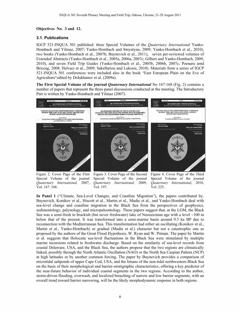
The First Special Volume of the journal Quaternary International No 167-168 (Fig. 2) contains a number of papers that represent the three panel discussions conducted at the meeting. The Introductory Part is written by Yanko-Hombach and Yilmaz (2007).
Figure 2. Cover Page of the First Special Volume of the journal Quaternary International, 2007, Vol. 167–168.
Figure 3. Cover Page of the Second Special Volume of the journal Quaternary International, 2009, Vol. 197.
Figure 4. Cover Page of the Third Special Volume of the journal Quaternary International, 2010, Vol. 225.
In Panel 1 (“Climate, Sea-Level Changes, and Coastline Migration”), the papers contributed by. Buynevich, Konikov et al., Hiscott et al., Martin et al., Mudie et al., and Yanko-Hombach deal with sea-level change and coastline migration in the Black Sea from the perspectives of geophysics, sedimentology, palynology, and micropaleontology. These papers suggest that, at the LGM, the Black Sea was a semi-fresh to brackish (but never freshwater) lake of Neoeuxinian age with a level ~100 m below that of the present. It was transformed into a semi-marine basin around 9.5 ka BP due to reconnection with the Mediterranean Sea. This transformation had either an oscillating (Konikov et al., Martin et al., Yanko-Hombach) or gradual (Mudie et al.) character but not a catastrophic one as proposed by the authors of the Great Flood Hypothesis, W. Ryan and W. Pitman. The paper by Martin et al. suggests that Holocene sea-level fluctuations in the Black Sea were stimulated by multiple marine incursions related to freshwater discharge. Based on the similarity of sea-level records from coastal Delaware, USA, and the Black Sea, the authors propose that the two regions are climatically linked, possibly through the North Atlantic Oscillation (NAO) or the North Sea Caspian Pattern (NCP) at high latitudes or by another common forcing. The paper by Buynevich provides a comparison of microtidal saltponds of upper Cape Cod, USA, and the limans of the non-tidal northwestern Black Sea on the basis of their morphological and barrier-stratigraphic characteristics, offering a key predictor of the near-future behavior of individual coastal segments in the two regions. According to the author, storm-driven flooding, overwash, and localized breaching of narrow and low barrier segments, with an overall trend toward barrier narrowing, will be the likely morphodynamic response in both regions.

INQUA 501 Seventh Plenary Meeting and Field Trip, Odessa, Ukraine, 21-28 August 2011
7
The paper by Koral explores the influence of the North Anatolian Fault on uplift, subsidence, lateral movement, and coastal modification of the Sea of Marmara. The author indicates that active tectonics reveals three different modes in the Marmara region of northwestern Turkey, and he attempts to determine their rates over the recent geological past. The paper of Meriç and Algan also deals with the Sea of Marmara. Based on paleontological and sedimentological data, the authors reconstruct the level of the Sea of Marmara as reaching its present littoral by 8 ka BP due to the influence of Mediterranean water.
The paper by Akçar et al. reports that build-up of a snow-avalanche ridge started in the Late Glacial after the retreat of paleoglaciers in the Verçenik and Kavron Valleys of the Eastern Black Sea Mountain range in northeastern Turkey.
The paper by Khoshravan describes beach sediments, morphodynamics, and risk assessment on the Iranian coast of the Caspian Sea, while the paper by Ergin et al. deals with sea-level changes recorded in sediment composition off the Büyük Menderes River delta (eastern Aegean Sea, Turkey).
In Panel 2 (“GIS-Aided Mathematical Modeling”), Kislov and Toropov present their research on East European river runoff and sea-level changes in the Black and Caspian Seas using simulations of the Paleoclimate Modeling Intercomparison Project. The authors conclude that during the late-Pleistocene and post-glacial, both the Caspian and Black Seas fluctuated between regressive and transgressive stages, but fluctuations in the Black Sea were smaller because they were mainly controlled by the World Ocean due to water exchange through the Bosphorus Strait.
Panel 3 (“Influence of Environmental and Other Factors on Human Settlement: Archaeological and Historical Evidence”) is represented by three papers: those by Dolukhanov and Arslanov, Séféraidès, and Smyntyna. These papers deal with the archaeology and ethnology of the ancient humans in the Caucasus littoral, the Aegean, and the lower Danube region, respectively. All authors agree that there were influences from natural paleogeographic processes (e.g., climate oscillations) on the early human settlements of the Black Sea and Aegean Sea regions.
The Second Special Volume of the journal Quaternary International Vol. 197 Issues 1-2 (Fig. 3) that contains papers from the Second and partially Third Plenary Meeting in 2006 and 2007, rtespectively. The Introductory Part was written by Yanko-Hombach and Smyntyna (2009).
This volume was dedicated to the memory of Prof. Vladimir Stanko (deceased February 16, 2008), the brilliant Ukrainian archaeologist who entered the area of scholarship in the 1960s and made a huge contribution elucidating the hitherto poorly known prehistory of the northern Black Sea area. We are honored to publish his last paper in this volume.
The paper by Stanko summarizes the shifts in population dynamics in the northern coastal zone of the Black Sea for the 10,000 years from the Last Glacial Maximum to the Neolithic advance. On the basis of diachronic analysis of the flint industry, faunal assemblages, and paleoclimatic data originating from Late Paleolithic and Mesolithic archaeological sites of this region, the author put forward his hypothesis that the population of this region influenced the process of cattle adoption in the Balkans and Asia Minor, disproving at the same time the possibility that the Grebenyky culture originated from the Balkan Neolithic cultures. He also stressed the absence of a causal link between the Black Sea Flood (if it ever existed) and the population dynamics in the Pryčornomorja Steppe and Balkans during the Mesolithic and Neolithic periods.
The paper by Dolukhanov et al. is based on detailed surveys and reconstructions of coastal and marine environments of the northwestern Black Sea shelf for the time spans of ca. 25, 18, 12, 10–7 and 7–4 ka BP. It is shown that during the great part of the Late Pleistocene and Early Holocene, the Black Sea remained a landlocked basin of Caspian type that was colonized by early modern humans starting from ca. 40 ka. The subsequent evolution of coastal landscapes was generally conditioned by the gradual rise of sea level and increasing temperature and precipitation, resulting in the formation of wetland-type coastal landscapes that became the main source of Late Paleolithic and Mesolithic subsistence. The initial indications of farming activities are coeval with the Kalamitian stage, being conditioned by the increased temperature and precipitation combined with the formation of fertile soils under

INQUA 501 Seventh Plenary Meeting and Field Trip, Odessa, Ukraine, 21-28 August 2011
8
Altithermal conditions. The records fail to indicate a catastrophic breakthrough of Mediterranean water that could have had any effect on the subsistence or migrations of early farming communities.
The paper by F. Marret et al. deals with the two-step transformation of the Neoeuxinian brackish water lake into the Black Sea based on dinoflagellate cyst records from core material collected from the southwestern Black Sea shelf. This record shows strong evidence of a gradual reconnection between the Black and Mediterranean seas at the beginning of the Holocene. A first major pulse of marine water is recorded at around 8.46 ka BP, with a maximum of L. machaerophorum. The occurrence of this species from the bottom of the core, dated at 9.3 ka BP, supports the hypothesis that water levels were already high on the southwestern shelf by that time.
The paper by A. Svitoch presents a critical review of the hypothesis suggested by Chepalyga that the Khvalynian transgression, which resulted from abundant inflow of meltwater from Siberian proglacial lakes through the Aral Sea and along the Uzboi channel into the Caspian Sea, had a catastrophic character and could be considered as a prototype of the biblical Noah's Flood. According to the author, there is no single evidence that the Khvalynian transgression could serve as a reliable source for the biblical Noah's Flood tradition.
The paper by Peev deals with the neolithization of the Eastern Balkan Peninsula and the influence of fluctuations of the Black Sea level on this process. Based on geomorphologic and stratigraphic analyses of prehistoric settlements, the author concludes that there were river settlements situated at the mouth of lower river valleys. The author suggests that the neolithization of the Bulgarian Black Sea region occurred later than it did in Thracia or Northeastern Bulgaria. However, the latest investigations on the Black Sea level during the Middle Holocene are under way and may change this hypothesis.
The paper by Riehl concerns archaeobotanical evidence for the interrelationship of agricultural decision-making and climate change in the ancient Near East. On the basis of GIS-mapping, archaeobotanical evidence from 138 archaeological sites of the Levant, Syria, and Northern Mesopotamia spanning from 5000 cal. BP to 2500 cal. BP, the author proposes developmental patterns related to the paleoclimatic history of the region. As a result, he demonstrated that Early Bronze Age crop assemblages are correlated with periods of favorable moisture, while the event of 4200 BP and the subsequent increase of aridity after 4000 BP is reflected in the reduction or absence of drought-susceptible crop species in the Middle Bronze Age. Further slight development of arid conditions during the Late Bronze Age are displayed in crop proportions mainly in northern Syria but not traced in the Southern Levant. Iron Age crop patterns suggest a slightly better water availability. On this basis, the author concludes that in spite of certain methodological problems, it is possible to establish a correlation between agricultural decision-making in the ancient Near East and climate changes in the past.
The paper by Koral et al. presents evidence of coastal uplift on the Gökçeada (formerly Imbros) Island that is situated in the northern Aegean Sea in close proximity to a deep trough along the seismically active North Anatolian Fault (NAF). Field evidence of many coastal morphological, geological, and tectonic features together with corresponding seismic reflection data suggests that the island has experienced a rapid uplift with respect to the Saros Trough along the NAF. Total uplift is on the order of a few kilometers since the initiation of the NAF during the Pliocene (or later during the Pleistocene as suggested by some studies), and the yearly rate varies from a few millimeters up to a centimeter according to the age assumed for this major fault.
The Third Special Volume of the journal Quaternary International Vol. 225 Issue 2 (Fig. 4) includes nine papers presented at the Second and Third Plenary Meetings in Odessa and Gelendzhik/Kerch in 2007. The Introductory Part was written by V. Yanko-Hombach, S. Kroonenberg, and S. Leroy (Yanko-Hombach et al., 2010).
This volume is dedicated to the memory of Prof. Pavel Dolukhanov (deciesed 6 December 2009) who was a rare individual. A product of the Russian intelligentsia, his defining features were an intellectual sophistication, deep understanding of human nature, and empathy for human beings that arose from a broad-based educational background. After the fall of the USSR, he moved to the UK, where his knowledge of languages and his contacts in the former Soviet Union gave him an encyclopedic

INQUA 501 Seventh Plenary Meeting and Field Trip, Odessa, Ukraine, 21-28 August 2011
9
knowledge of prehistory across the vast territories of Eastern Europe. As someone who lived and worked in two very different worlds of scholarship and moved easily between them, Prof. Dolukhanov had an unrivalled perspective on European prehistory. His recent research is yet to appear due to the efforts of his colleagues and associates, but we were honored to publish his last paper in this volume.
The paper by Dolukhanov et al. focuses on the Khvalynian Transgression and early human settlement in the Caspian basin. This transgression occurred as a rapid succession of sea-level fluctuations, most probably between 13.6–11.8 ka BP according to uncalibrated radiocarbon dates. It was largely coeval with the expansion of Mousterian sites that took place after the Atelian regression that was synchronous with the Last Glacial Maximum. The authors present evidence that specific environments arising in the Caspian basin favored a prolongation of the Mousterian technique, and possibly, survival of Neandertal populations.
Brückner et al. conduct a critical analysis of published sea-level curves for the Black and Mediterranean Seas in their paper. According to the authors, the lack of correspondence between the curves is due to poor sea-level indicators and questionable use of 14C dating as well as interference by tectonic signals that often override eustatic ones. The authors insist that only local sea-level curves can truly reflect sea-level fluctuations in the Black Sea, as can be demonstrated by their sea-level curve for the Taman Peninsula. The proposed curve was assembled from 14C dates of paralic peats used as sea-level indicators and is comparable with the curve from the Mediterranean Sea. In the cooperative spirit of the IGCP 521 - INQUA 501 presentations, the substantial diversity in reviewers’ opinions and authors’ responses have prompted the publication of this paper together with selected comments in order to stimulate discussion of the sea-level history of the Black Sea.
Esin et al. deal with freshwater balance during the Upper Pleistocene-Holocene based on geological data and mathematical modeling. They consider change of water volume inflowing to the Black Sea to be a result of ablation, neotectonic processes in the strait, bottom erosion, and sediment accumulation. According to the authors, their proposed theory of fluctuations in Black Sea level is self-sufficient, explains all processes by physical laws, and does not demand application of any additional hypotheses.
Kontopoulos and Koutsios discuss the evolution of a coastal lagoon in the northwestern Peloponnesus, Greece, as influenced by the interaction of sea level and sediment accumulation. From prior to 7000 BP to 3810 cal BP, lagoonal sediments accumulated. Subsequently, fluvial sediments accumulated as the rate of sedimentation was higher than the rate of relative sea-level change, possibly because of the proximity of the mouth of the Peneus River. After 1400 cal BP, landward migration of the coast and the reestablishment of lagoonal facies resulted from avulsion of the Peneus River.
Lericolais et al. attempt to integrate high-resolution, single-channel seismic reflection profiles and Calypso piston cores recovered along a transect extending from the Danube delta into its deep sea fan in order to provide information on the Late Quaternary architecture of the Danube Black Sea shelf and on the role of global glacio-eustatic fluctuations on the building of the Danube delta/prodelta. Based on these data, the authors try to demonstrate that the sedimentary sequences in the Black Sea are strongly affected by water-level changes, but for the entire duration of the Late Glacial-Holocene period, the level of the Black Sea was controlled by regional climate modifications rather than by global eustatic changes. In partial agreement with Ryan’s (2003) model, the authors also suggest two lowstands of the Black Sea. However, if Ryan’s model dates his first –120 m lowstand between 13.4 and 11.0 ka 14C BP, Lericolais et al. propose a –120 m lowstand at the LGM, when the Black Sea was a land-locked lake. Both models suggest that a second lowstand at about –100 m occurred at 11.0–8.5 ka 14C BP under an arid and dry climate, and was followed by a rapid transgression starting immediately after 8.5 ka 14C BP. The results of the paper are part of a heated debate, which was reflected by the lack of agreement in the reviews received about this paper. One point of contention is whether the Early Holocene climate of the Black Sea was arid or not.
The paper by Levchenko and Roslyakov refers to new high-resolution shallow-marine seismic data that have been obtained with the Rift research vessel, thanks to increased interest in hydrocarbon exploration in the Caspian. The spectacular sediment waves reported in this paper have much in common with gravity structures (for example, in the Adriatic Sea) interpreted by the authors as having been formed by turbiditic density flows, though the extreme regularity of the features is also

INQUA 501 Seventh Plenary Meeting and Field Trip, Odessa, Ukraine, 21-28 August 2011
10
reminiscent of slope failures. There are several generations of waves in the seismic profiles, probably formed mainly during regressions, but due to the lack of coring data from these sites, their age and significance for the sea-level history of the Caspian can be appreciated only in an approximate way by correlation with cores from other areas.
Shkatova’s paper discusses the stratigraphy of a series of classic Pleistocene outcrops along the Lower Volga in the North Caspian Plain on the basis of U-Th, ESR, and TL age data. The lowermost strata are correlated with the Late Khazarian transgression dated between 127–122 ka, corresponding with MIS 5e. This was followed by a regression between 114 and 87 ka. Overlying strata mainly reflect the Early and Late Khvalynian transgressions with TL ages spanning 77–16 ka. Two magnetic excursions were identified at 117 and 89 ka. These results are internally very consistent and seem to corroborate older hypotheses that glacial highstands in the Caspian correspond with lowstands in the oceans, though many hiatuses in the record warrant much more detailed investigations in the future, and require further correlation with more continuous records from offshore.
The paper by Svitoch describes the Neoeuxinian (Late Glacial-Early Holocene) deposits in the Black Sea and their relation to sea-level change in the Caspian. Biostratigraphical evidence exists for overflows from the Caspian into the Black Sea during glacial Caspian highstands. The age of the last of these overflows is still highly controversial, with opinions ranging between 70 ka and 13 ka. Svitoch argues in favor of the younger ages. Predominantly brackish mollusk assemblages do not support the popular notion by Groswald that the Caspian highstand was the result of inflow from Siberian proglacial meltwater lakes through the Turgay pass. The overflow was also not torrential, as other authors including Chepalyga suggest, but a quiet overflow, according to Svitoch. However, many of the age determinations are conventional 14C dates that were obtained 30–40 years ago, and there are no modern geochronological studies to corroborate these views.
Finally, Wallace presents his approach to assembling the paleoenvironmental and archaeological data obtained by IGCP 521 in order to create a high resolution “big picture” available to the world at large through the development of an experimental web-database application. This application is accepting data from researchers worldwide, supplemented by GIS coordinates, depth/elevation, age (historical, geological, or archaeological), and associated metadata plotted by longitude and latitude on a bathymetric map of the “Corridor.” Each point on the web-based map presentation is “clickable” to reveal the source, metadata information, and links to further information. Data are also displayed as depth/elevation on a corresponding screen. The data points can be questioned, commented on, even rejected if invalid and replaced by leading-edge data. Yet, once entered, all data are likely to stand the test of time and will gain resolution, clarity, accuracy, and precision. Such a system can extend beyond the active life of IGCP 521 to become a legacy—a living data archive possessing considerable longevity for students, academics, and industrial researchers well into the future.
The book “The Black Sea Flood Question: Changes in Coastline, Climate, and Human Settlement” (Yanko et al., 2007c; Fig. 5) brings together 35 papers on geological, hydrological, climatological, archaeological, and linguistic aspects of the Black Sea flood hypotheses. Data and discussions reflect efforts at discerning and understanding paleoenvironment, climate dynamics, sea-level changes and coastline migration, regional hydrological variations, active tectonics, and geomorphology as parameters influencing human adaptation to the Circum-Pontic Region since the Last Glacial Maximum. Only empirical evidence recovered through accepted scientific methods was considered, and speculative implications linking Black Sea events to biblical narrative, as has increasingly happened in popular books and media reports, was avoided. No final answer to the Black Sea flood question appears here. Each paper in this book marshals its own evidence and offers its own interpretations, and there is no summary at the end with an overall resolution. The goal has been to provide access to information on a broad scale that crosses previously impenetrable language barriers, so that new work in the region can proceed with the benefit of greater perspective. The three fundamental scenarios for late glacial to Holocene rise in the level of the Black Sea—catastrophic (Ryan), gradual (Hiscott et al.), and oscillating (Chepalyga and Yanko-Hombach)—are presented early in the book, with the succeeding papers organized by geographic sector: northern (Ukraine), western (Moldova, Romania, and Bulgaria), southern (Turkey), and eastern (Georgia and Russia), as well as three papers on the Mediterranean. The Editors hope that the contributions of this volume will serve as
INQUA 501 Seventh Plenary Meeting and Field Trip, Odessa, Ukraine, 21-28 August 2011
11
a foundation for designing more inclusive collaborative investigations and building greater consensus about what the past century’s discoveries in the Circum-Pontic Region mean.
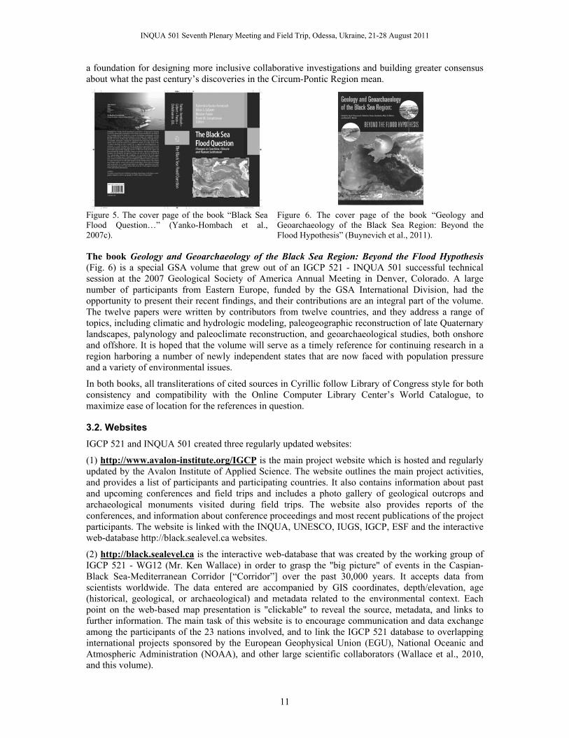
Figure 5. The cover page of the book “Black Sea Flood Question…” (Yanko-Hombach et al., 2007c).
Figure 6. The cover page of the book “Geology and Geoarchaeology of the Black Sea Region: Beyond the Flood Hypothesis” (Buynevich et al., 2011).
The book Geology and Geoarchaeology of the Black Sea Region: Beyond the Flood Hypothesis (Fig. 6) is a special GSA volume that grew out of an IGCP 521 - INQUA 501 successful technical session at the 2007 Geological Society of America Annual Meeting in Denver, Colorado. A large number of participants from Eastern Europe, funded by the GSA International Division, had the opportunity to present their recent findings, and their contributions are an integral part of the volume. The twelve papers were written by contributors from twelve countries, and they address a range of topics, including climatic and hydrologic modeling, paleogeographic reconstruction of late Quaternary landscapes, palynology and paleoclimate reconstruction, and geoarchaeological studies, both onshore and offshore. It is hoped that the volume will serve as a timely reference for continuing research in a region harboring a number of newly independent states that are now faced with population pressure and a variety of environmental issues.
In both books, all transliterations of cited sources in Cyrillic follow Library of Congress style for both consistency and compatibility with the Online Computer Library Center’s World Catalogue, to maximize ease of location for the references in question.
3.2. Websites IGCP 521 and INQUA 501 created three regularly updated websites:
(1) http://www.avalon-institute.org/IGCP is the main project website which is hosted and regularly updated by the Avalon Institute of Applied Science. The website outlines the main project activities, and provides a list of participants and participating countries. It also contains information about past and upcoming conferences and field trips and includes a photo gallery of geological outcrops and archaeological monuments visited during field trips. The website also provides reports of the conferences, and information about conference proceedings and most recent publications of the project participants. The website is linked with the INQUA, UNESCO, IUGS, IGCP, ESF and the interactive web-database http://black.sealevel.ca websites.
(2) http://black.sealevel.ca is the interactive web-database that was created by the working group of IGCP 521 - WG12 (Mr. Ken Wallace) in order to grasp the "big picture" of events in the Caspian-Black Sea-Mediterranean Corridor [“Corridor”] over the past 30,000 years. It accepts data from scientists worldwide. The data entered are accompanied by GIS coordinates, depth/elevation, age (historical, geological, or archaeological) and metadata related to the environmental context. Each point on the web-based map presentation is "clickable" to reveal the source, metadata, and links to further information. The main task of this website is to encourage communication and data exchange among the participants of the 23 nations involved, and to link the IGCP 521 database to overlapping international projects sponsored by the European Geophysical Union (EGU), National Oceanic and Atmospheric Administration (NOAA), and other large scientific collaborators (Wallace et al., 2010, and this volume).

INQUA 501 Seventh Plenary Meeting and Field Trip, Odessa, Ukraine, 21-28 August 2011
12
(3) http://www.bridge.bris.ac.uk/projects/EMBSECBIO was created by the Palynology Group (WG-2) of the IGCP 521 - INQUA 501 project. The website is hosted by S. Harrison, Bristol University, UK, and contains the pollen database that will lead to the biomization of the Black Sea-Mediterranean Corridor. The aim of the WG-2 group is to reconstruct changes in vegetation patterns and fire regimes in the Mediterranean-Black Sea-Caspian Sea Corridor over the past 30,000 years. Maps showing the advances in database entry can be found at this website, along with the research and data entry protocols.
All information received during the conferences and workshops, and all published resources and websites, are widely disseminated among students, post-graduates, researchers, and professors at universities and other higher educational institutions in developing countries contributing to a spin-off of “educational reform” in the fields of Earth, Behavioral, and Atmospheric Sciences, thus, improving competitiveness among young scientists and enhancing their employment opportunities. Information obtained during Plenary Conferences, Field Trips, and other activities was useful for some MSc and PhD students; about 50 theses related to IGCP 521 - INQUA 501 topics are in progress or were defended in 2005–2010.
Objective No. 5.
The database of 14C assays for the Black Sea portion of the “Corridor” is presented in Balabanov (2007a; 2009) and Yanko-Hombach (2007b).
Objective No. 6.
The main research results submitted by the Coordinators of Working Groups are as follows.
WG1 “Paleontology and biostratigraphy” established several reference collections of Quaternary benthic foraminifera and mollusks from the Black Sea, Sea of Azov, and Eastern Mediterranean. These collections will allow us to improve the stratigraphic scale for the last 30 kyr and to provide correlation of various geological settings in the “Corridor.” The collections are stored at the Paleontological Museum of Odessa I.I. Mechnikov National University, Odessa, Ukraine (contact person Prof. Yanko-Hombach, [email protected]), Institute of Geography of the Russian Academy of Science, Moscow, Russia [contact person Prof. Chepalyga, [email protected]), and Moscow State University named after M.V. Lomonosov [contact person Dr. Yanina [email protected]].
WG2 “Palynology” has collaborated with the BIOME 6000 team (the Global Palaeovegetation Mapping subprogram) under the international program IGBP (International Geophysical-Biophysical Program) at Bristol University, and with members of IGCP 480 to compile existing pollen data sets for about 100 sites in the Caspian-Black Sea-Mediterranean Corridor, and to employ a student who will make biomization models for these data at selected time intervals over the past ca. 20,000 years. Through inter-laboratory exchange of technology and students, we have also established a system of standardized marine palynology preparation methods and taxonomy for study of the Black Sea corridor sediments and the palynomorphs to allow future interpretations to be based on the same types of assemblages and using updated nomenclature. Over the past 5 years, WG2 has produced more than 10 papers on the regional palynology in scientific journals (e.g., Cordova et al., 2009; Mudie et al., 2007), and Carlos Cordova has published one book “Millennial Landscape Change in Jordan: Geoarchaeology and Cultural Ecology” (Cordova, 2007). The group developed a research protocol for the Eastern Mediterranean-Black Sea-Caspian Biomes (EMBSeCBIO) and created a pollen and dinoflagellate database leading to biomization of the EMBSeCBIO (Cordova et al., 2009), [contact person Dr. Mudie [email protected]].
WG3 “Geophysics and sequence stratigraphy” (Team of Prof. Aksu) contributed new high-resolution data from the southwestern Black Sea that show (1) the reconnection of the Mediterranean and Black Seas before 8.6 ka BP, (2) the absence of catastrophic flooding at any time during the Holocene, and (3) the presence of brackish to slightly saline water in the Black Sea during the Holocene (Flood et al., 2008; Hiscott et al., 2007a,b; 2009). In 2009, activities focused on (a) processing and cleaning of the 2008 multibeam mosaic, collected from the Bosphorus exit into the
INQUA 501 Seventh Plenary Meeting and Field Trip, Odessa, Ukraine, 21-28 August 2011
13
Black Sea to the boundaries of the 2005 survey area, thus enlarging the coverage of seabed features to image essentially all of the saline density-current channel on this part of the shelf, and (b) updating and refinement of chronological data for a mid-shelf delta south of the Bosphorus exit into the Marmara Sea. The Team of Dr. Lericolais proposed that the level of the Black Sea was linked to regional climate modifications rather than to global eustatic changes. During the LGM, the Black Sea was an enclosed lake –120 m below present. Deglaciation raised the lake level to –30 m, and then again to –100 m between 11 and 8.5 ka BP followed by rapid transgression starting just after 8.5 ka BP (Lericolais et al., 2007; 2011). [contact persons Prof. Hiscott [email protected], and Dr. Lericolais [email protected]].
WG4 “Sedimentology and mineralogy” developed a high-resolution geological model of sedimentation on the NW Black Sea shelf (Larchenkov and Kadurin, 2011) that reveals significant periodicities of sedimentation related to sea-level change and hydrodynamic activity (Martin and Yanko-Hombach, 2011) [contact person Prof. Martin [email protected]].
WG5 “Geochemistry” developed a new approach to investigate amino acid racemization and AMS radiocarbon dating of Holocene Black Sea core sediments that aimed to utilize the amino acid racemization (AAR) geochronological technique to date a number of shells in Holocene cores from the Black Sea, and investigate the possible extent of time-averaging in Black Sea sediments (Nicholas et al., 2009, 2010) [contact persons Mr. Nicholas [email protected] and Prof. Chivas [email protected]].
WG6 “Structural geology and active tectonics” evaluated the role of active tectonics on sea-level change and coastal processes in the Black Sea, the Marmara Gateway, the Aegean Sea, northern Turkey, and the northwestern part of the Black Sea (Koral, 2007; Yılmaz, 2007) [contact persons Prof. Koral [email protected], Prof. Yılmaz [email protected], and Prof. E. Larchenkov [email protected]].
WG7 “Geomorphology” developed the Black Sea level curve in radiocarbon (Balabanov, 2007b) and calendar (Balabanov and Arslanov, 2007) time scales for the last 12 kyr [contact person Dr. I. Balabanov ([email protected]]. While some authors (Martin and Yanko-Hombach, 2011) agreed that despite its possible drawbacks, the synoptic curve of Balabanov appears to reflect relatively subtle eustatic sea-level change related to hemispheric—and perhaps even global—climatic phenomena [contact person Prof. Martin [email protected]], some others (Brückner et al., 2010) insisted that tectonic signals often override the eustatic ones, and as such, establishing a local sea-level curve is the only one valuable option [contact person Prof. Brückner [email protected]].
WG8 “Paleoceanography and paleoclimatology” described paleoceanographic evolution in terms of paleotemperature, paleosalinities, paleoproductivity, circulation patterns, and efficiency of the Manych (Chepalyga, 2007) and Marmara Gateways (Hiscott et al., 2007) for given time-intervals. They also traced the evolution of water masses in space and time, identified their possible sources, and reconstructed vegetation and climate dynamics in the “Corridor” since the LGM (Cordova et al., 2009) [contact person Dr. I. Balabanov [email protected]].
WG9 “Archaeology” developed an interdisciplinary model of ecological crisis dynamics for the NW Black Sea coast and adaptive reaction of ancient people to changeable environmental conditions at the Late Pleistocene-Holocene boundary, provided quantitative assessment of the impact of environmental changes on the spread of early farming in the northern Black Sea area, and investigated the Lower Volga in order to reconstruct Late Pleistocene and Holocene paleoenvironment and geochronology of Mesolithic-Early Neolithic settlements (Dolukhanov et al., 2009b) [contact person was Prof. Dolukhanov]. The group also provided in-depth study of transmigrations as a mechanism of living space exploration in the Northwestern Black Sea region at the Pleistocene-Holocene boundary (Smyntyna, 2007; Yanko-Hombach et al., 2011a,b) [contact person Prof. Smyntyna [email protected]], and studied the cultural sequences, the emergence of food-producing village economies in SE Europe, and the collection of various rocks that have been used in the prehistory of the Southern Marmara (Özdoğan, 2007) [contact person Prof. Özdoğan [email protected]].

INQUA 501 Seventh Plenary Meeting and Field Trip, Odessa, Ukraine, 21-28 August 2011
14
WG10 “Radiocarbon chronology” established a data set on radiocarbon assays obtained in eastern (Balabanov, 2007a; 2009) and western (Yanko-Hombach, 2007b) laboratories [contact person Prof. Arslanov [email protected]].
WG11 “GIS-added mathematical modeling” developed several mathematical models of: (1) the Late Pleistocene and Holocene transgressions of the Black Sea (Esin et al., 2010) that describe the process by which the Black Sea basin filled with freshwater. The model takes into consideration the temporal changes of freshwater balance, rate of uplift of the strait’s bottom, and geometry of the strait channel. This model is self-sufficient, explains all processes from the melting of the glaciers by physical laws and does not demand the application of any additional hypotheses (contact person Dr. N. Esin [email protected]]; (2) the extreme Black Sea and Caspian Sea levels of the past 21,000 years with general circulation models (Kislov and Toropov, 2011) [contact person Prof. Kislov [email protected]]; and (3) the transition from the Mesolithic to the Neolithic, from about 7000 to 4000 BC in Europe (Davison et al., 2006) [contact person Prof. Shukurov [email protected]].
WG12 “Geoinformation system” created the interactive website http://black.sealevel.ca. Its GIS-added Web-database and science informatics permits creation of the “big picture” of the influence of climate, sea-level change, and coastline migration on human adaptive strategies in the “Corridor” (Wallace, 2010; Wallace et al., this volume) [contact person Mr. K. Wallace [email protected]].
Objective No. 7.
The regional chronostratigraphical frameworks for the various areas of the “Corridor” and their correlation based on 14C dates as well as geophysical and paleontological data is under development and will be discussed in the course of the Final Meeting.
Objective No. 8.
A mathematical model of the Black Sea basin filling with freshwater in the Upper Pleistocene-Holocene was developed. It considers that change in water volume inflowing to the Black Sea was a result of ablation, neotectonic processes in the strait, bottom erosion, and sediment accumulation. Black Sea level change calculations have shown the following. As a result of repeated increases in river runoff during glacial melting, the level of the Black Sea started to rise from –80 m, probably to –20/–30 m, making, in the process, numerous secondary fluctuations. The reason for this phenomenon was the circumstance that the water volume brought by the rivers could not flow to the Sea of Marmara through the narrow canyon of the Bosphorus Strait at the time. Therefore, water collected in the sea, raising its level. At approximately 12 ka BP, the World Ocean level rose to the river surface and began to increase its depth. As a result of the increase in strait depth, the accumulated water in the Black Sea flowed out, thereby lowering its level to a mark close to that of the Ocean level. According to calculations, this occurred ca. 11 ka BP. Thereafter, the Black Sea level rose together with the Ocean level. Water within the Sea of Marmara has flowed into the Black Sea since approximately 9 ka BP in the form of a bottom counterflow. With a small time delay, theoretical change in the Black Sea level practically corresponds to data obtained from geological investigations (Esin et al., 2010).
Objective No. 9.
The model describes the relationship between sea levels and climate based on the links between sea-level variations and river runoff. During the final Late Pleistocene and postglacial periods, the Caspian Sea fluctuated between regression and transgression stages. The Black Sea experienced fluctuations as well, but these were mainly controlled by the World Ocean due to water exchange through the Bosphorus Strait. Sometimes, the Caspian Sea overflowed into the Black Sea through the Manych Strait, and they periodically coalesced. Change in the level of both seas could be interpreted as responses to the regional-scale water budget (the balance between inflow and outflow components). These components can be calculated from atmospheric general circulation models. This approach uses climate modeling data to reproduce river runoff changes, and, consequently, variations in seawater and sea level under contrasting climate conditions (Kislov and Toropov, 2011).

INQUA 501 Seventh Plenary Meeting and Field Trip, Odessa, Ukraine, 21-28 August 2011
15
Objective No. 10.
The mathematical model of human dispersal developed by Sarson et al. (2007) has significant implications for the understanding of the Neolithization of Europe. It substantiates their suggestion that the spread of the Neolithic involved at least two waves propagating from distinct centers, starting at about 8200 BC in Eastern Europe and 6700 BC in the Near East. The earlier wave, spreading from the east via the ‘steppe corridor’, resulted in the establishment of the ‘eastern version’ of the Neolithic in Europe. A later wave, originating in the Fertile Crescent of the Near East, is the well-studied process that brought farming to Europe. Regardless of the precise nature of the eastern source, the current work suggests the existence of a wave which spread into Europe from the east carrying the tradition of early Neolithic pottery-making. If confirmed by further evidence (in particular, archaeological, typological, and genetic), this suggestion will require serious re-evaluation of the origins of the Neolithic in Europe.
The problem of parameter estimation for a wavefront model of the spread of Neolithic farming practices using radiocarbon data from sites throughout Europe is well known. The Sarson team first modeled arrival times at each site by a numerical solution to the propagating wavefront via an innovative numerical scheme that is orders of magnitude more efficient than traditional PDE approaches (Sarson et al., this volume).
Objective No. 11.
In order to grasp the “big picture” of paleoenvironmental and archaeological events in the Black Sea-Mediterranean Corridor, an experimental Web-database application was designed that will accept data from scientists and other researchers worldwide (Wallace, 2010; Wallace et al., this volume). Data are entered with GIS coordinates, depth/elevation, age (historical, geological, or archaeological) and associated metadata and are plotted by longitude and latitude on a bathymetric map of the Corridor. These data from the twelve Working Groups are combined, consolidated, and visualized, and each point on the Web-based map presentation is “clickable” to reveal the source, metadata information, and links to further information. Data are also displayed as depth/elevation on a corresponding screen. The prototype system demonstrates the potential to display all available data sets in millennial time slices, and to create displays and juxtapositions of datasets that have rarely or never co-existed before because of political, linguistic, and disciplinary boundaries, and rivalry over project funding. The WG12 collaboration breaks down these perceived boundaries to bring together information from multiple nations, speaking almost as many native languages, allowing them to share data at annual meetings from 2005 through 2011. Because the project funding cycle is nearing its end, however, this remarkable multi-national liaison is in danger of disintegrating after 2011, depriving the resulting database of a living quality. At this time, therefore, there is an urgent need to encourage database entry from team members, both during and beyond the IGCP 521 lifespan. In principle, the data gathered and assembled are immutable. The data points can be questioned, commented on, even rejected if invalid and replaced by leading-edge data. Yet once entered, all data are likely to stand the test of time and will gain resolution, clarity, accuracy, and precision. Such a system can go beyond just the duration of IGCP 521 - INQUA 501 and become a legacy—a living data archive—with considerable longevity for students, as well as academic and industrial researchers well into the future.
Objective No. 13.
Six Annual Scientific and Financial Reports have been submitted to IGCP and INQUA following the Guidelines, which are quite similar in both organizations. They include: Website address(es) related to the project; summary of major past achievements of the project; achievements of the project in a given year; list of countries involved in the project; general scientific achievements and social benefits; list of meetings with approximate attendance and number of countries; educational, training, or capacity building activities; participation of scientists from developing countries, and in particular young and women scientists; lists of the most important publications (including maps); activities involving other IGCP projects, UNESCO, IUGS or others; activities planned; general goals; tentative list of specific meetings and field trips with identification of participating countries; project funding request; request for extension, on-extended-term-status, or intention to propose successor project; financial statement
INQUA 501 Seventh Plenary Meeting and Field Trip, Odessa, Ukraine, 21-28 August 2011
16
($ USD only) with identification how IGCP and INQUA funds were used and if additional funding was obtained from different sources.
Objective No. 14.
In respect to theoretical sciences, the projects has yielded fundamental new knowledge about the driving mechanisms influencing human adaptation in the region, a subject of great interest to researchers working in Quaternary, earth, marine, environmental, and social sciences. Its strong applied component is directly relevant to coastal managers who assess environmental risk and sustainable development of the “Corridor” under the Global Climate Change anticipated to take full effect in this century. It also enhanced our knowledge on linear and non-linear geological processes and concepts through correlative studies of a wide range of sites through the “CORRIDOR”. It also provided better understanding of influence of global climate change and/or active tectonics on regional sea level fluctuations, coastline evolution, transformation from lacustrine to marine environment, eco- and sedimentary system as well as Prehistory and History human adaptation.
In respect to applied sciences, the project improved standards of research methods and techniques (e.g., the quantitative modelling of sea level change with the detailed identification of environmental factors involved and their behaviour). It also enabled to delineate the main areas of natural risk (e.g., inundation, erosion, flooding) required for the proper environmental management.
Objective No. 15.
With respect to the benefits to society, the projects were strongly interdisciplinary and involved collaboration between marine and terrestrial geologists, paleoceangraphers, archaeologists, and applied mathematicians, who studied the ”Corridor” as a single entity by bypassing disciplinary, geographical, national, and linguistic barriers. The projects met IGCP-INQUA aims in several ways: they promoted our knowledge and concepts about geological processes by correlating studies completed at a wide range of sites throughout the “Corridor”; and it enhanced our understanding of the links between environmental change and human adaptation. As such, the IGCP 521 - INQUA 501 projects contributed to an improvement in human living conditions, especially for those at risk from coastal flooding, promoting the wise use of the Earth as a human habitat; it correlates the results obtained in various laboratories by old and modern technologies.
Educational, training, or capacity-building activities of IGCP 521 - INQUA: (1) enabled participants to visit many relevant sites in the Black Sea-Mediterranean Corridor and observe them under the guidance of local experts with on-site discussion of scientific issues; (2) formed a platform for young undergraduate and postgraduate students to benefit from international exposure and interaction with scientists from different parts of the world and varied specialties. For example, a project involving the palynological study of cores from the coast and inner shelf of Ukraine has been agreed upon between Odessa University and Memorial University (Prof. Mudie). In the framework of this project, PhD student A. Gaponova (Odessa National University, Ukraine) was invited to Canada for 3 weeks of training in palynology and will continue these studies in conjunction with the palynology laboratory in Kiev (Prof. Gerasimenko). Another project involving geochemical study of cores obtained by the Ukrainian Team from the NW Black Sea was performed jointly by Odessa National University, Ukraine, and the University of Wollongong, Australia (Prof. Chivas). Within the framework of this project, a young scientist, Dr. Kadurin (Odessa National University, Ukraine), spent three weeks in Australia studying specialized geochemical equipment and associated methodology (e.g., RP-HPLC-reverse-phase high performance liquid chromatography for AAR dating) in the School of Earth and Environmental Sciences at the University of Wollongong, while a PhD student from this School, Mr. Nicholas, prepared his PhD Thesis using geological material from the Black Sea obtained by a Ukrainian team; (3) encouraged students to take new educational courses related to project topics, and to start working with a multidisciplinary approach that was intensely discussed during the conferences; (4) involved about 200 students from Bulgaria, Moldova, Romania, Russia, Ukraine, and Turkey to the organization of meetings and field trips, thus acquiring experience to develop their managing skills and abilities in order to cultivate traditions of “European style” scientific fora as well as scientific discussion and informal meetings. This also promoted their interest in chosen specialties and

INQUA 501 Seventh Plenary Meeting and Field Trip, Odessa, Ukraine, 21-28 August 2011
17
motivated them to learn foreign languages in order to improve communication skills with western colleagues; (5) promoted a multidisciplinary approach in paleoenvironmental studies, which encouraged students in geology to take archaeological courses and vice versa. This stimulated teachers to modify their curricula (e.g., Geology and minerals of the Black Sea; Environmental Micropaleonology; Quaternary Geology, General Climatology and Theory of Climate given at various universities); (6) promoted the establishment of direct contacts between western and eastern youth, creating the background for better understanding of modern priorities in the developing world of science and humanities; (7) exposed the younger generation in developing countries to new analytical techniques and state-of-the-art data interpretation in the field of sustainable development and environmental risk protection, as well as human cultural development.
IGCP 521 - INQUA 501 encouraged capacity-building activities through the opening of the Scientific and Educational Center of Geoarchaeology, Marine and Environmental Geology (SECGMEG) at Odessa I.I. Mechnikov National University. To date, SECGMEG has participated in EU FR6, the large-scale integrating project HERMES (http://www.eu-hermes.net/), and many other projects including field work (e.g., Ukrainian-Russian-Australian expedition on the Kerch peninsula in 2007) in the “Corridor.”
IGCP 521 - INQUA 501 conferences, field trips, and publications are conducted in strict agreement with the Working Plan [http://www.avalon-institute.org/IGCP/plan.html]. At the same time, achieved results exceed significantly planned ones.
Objective No. 16.
According to the plan, seven Plenary Meetings and Field Trips have been/will be carried out in various sites of the “CORRIDOR” during 2005-2011 (Fig. 1).
3.3. Plenary Conferences and Field Trips
3.3.1. The First Plenary Meeting and Field Trip The First Plenary Meeting was carried out in Istanbul, Turkey, on 8-15 October 2005, and was organized jointly by the Kadir Has University, Turkey, and the Avalon Institute of Applied Science, Winnipeg, Canada. Financial support for this meeting was contributed by IGCP (5000 USD), INQUA (5000 USD), INTAS (11000 USD), TUBITAK (10000 USD), Kadir Has University, Turkey (7250 USD in kind), Avalon Institute of Applied Sciences, Canada (5000 USD in kind), and Canadian Branch of IGCP (1100 CND). INTAS, IGCP and INQUA funds were used to cover travel expenses, accommodation and registration fee of 70 scientists from developing countries as well as local transportation and buses during Field Trips. In addition, a number of young scientists obtained support from the European Science Foundation to cover their travel expenses, accommodation and lodging. Few scientists from Australia, UK, and France were supported by local branches of IGCP for their travel to Istanbul.
President of the conference was Prof. Yucel Yilmaz. Executive Director was Prof. Valentina Yanko-Hombach.
This initial meeting was attended by 82 interdisciplinary scientists from 19 countries who explored the avenues of collaboration to discover the linkages between sea-level change, coastal evolution, and human adaptation in a variety of settings, ranging from tectonically active (e.g., Caucasian coast, Sea of Marmara) to stable (e.g., Manych Depression) areas as well as areas of temperate (e.g., North-Western coast of the Black Sea) to sub-tropical (e.g., Israeli coast) climate. Scientists from four continents were present at the meeting with Turkey, Russia, and Ukraine having the most participants.
The Abstract Volume for the First Plenary Meeting contained 82 extended abstracts (225 pages) written by 166 scientists from 19 countries (Fig. 7, 8).

INQUA 501 Seventh Plenary Meeting and Field Trip, Odessa, Ukraine, 21-28 August 2011
18
Figure 7. Cover page of the 2005 Abstract Volume (Yanko-Hombach et al., 2005a).
Figure 8. Number of countries and contributors to the 2005 Abstract Volume. Here and in Figures 13, 17, 21, 26, 31 in circles percentage of scientists from developing (light grey) and developed (dark grey) countries, respectively.
Figure 9. Cover page of the 2005 Field Trip Guide (Yanko-Hombach et al., 2005b).
The technical program was structured in four Panels and one Round Table. The Panels were subdivided into 10 sessions:
Panel 1. Climate, Sea Level Changes and Coastline Migration - Sessions: Geology, Geophysics, Hydrology and Sustainable Development; Palaeontology and Biostratigraphy; Palynology; Paleoclimatic Implications; Sedimentology, Geomorphology and Geochemistry; Tectonics.
Panel 2. Influence of Environmental and Other Factors on Human Settlement: Archaeological and Historical Evidences – Session Archaeology and History.
Panel 3. GIS-Added Mathematical Modeling – Session “Climate and Sea Level Modeling”.
Panel 4. Geo-Information System – Session: “Data elaboration”.
Round Table – IGCP 521 Potentials and Challenges - Reports of Regional Coordinators and Coordinators of Working Groups.
The Technical Sessions began with an overview of the IGCP 521-INQUA 501 project by Prof. Valentina Yanko-Hombach who presented the current state of knowledge on the “CORRIDOR”, its evolution and the potential for future research. Over the next three days, it was followed by a number of technical sessions with a wide spectrum of interdisciplinary topics presented in 58 ORAL and 22 POSTER contributions. The posters were displayed in a renovated part of the university, which sits atop of fantastic exhibit of excavated Roman-period baths over Byzanthine foundation.
Keynote addresses were delivered by Prof. Nikolay Panin (GeoEcoMar, Romania) “Controversy of the Black Sea development since LGM”; Prof. Petar Mudie (Geological Survey of Canada Atlantic) and Sandy Harrison (2University of Bristol, School of Geographical Sciences) “Palynological evidence of climate, salinity and man's influence in the Black Sea-Mediterranean Corridor during the last 30 ky: potentials and challenges”; Prof. Allan Chivas (School of Earth and Environmental Sciences, University of Wollongong, Australia) “Palaeochemistry of isolation basins”; Prof. Yucel Yilmaz (Kadir Has University, Turkey) “A morphotectonic approach to the development of the Bosphorus channel”; Prof. Mehmet M. Özdoğan (Istanbul University, Turkey) “M. Özdoğan”; and Prof. Vladimir Pushkar (Far Eastern Geological Instutite FEB RAS, Russia “Application of mathematical modelling to reconstructing global sea-level changes for the past 30 ky”.
The Technical Sessions was completed by a Round-Table Panel of the IGCP 521-INQUA 501 “Potentials and Challenges”. The reports of Regional Collaborators spanned all physiographic elements of the “CORRIDOR”, including Manych-Kerch Gateway; Caucasian North-Western, Western, and Southern Black Sea; Marmara Gateway, and the Aegean Coast. This panel included the reports of the Coordinators of the Working Group focusing on paleontology and biostratigraphy; palynology; sedimentology and mineralogy; geochemistry; structural geology and active tectonics; archaeology, and radiocarbon chrolnology.

INQUA 501 Seventh Plenary Meeting and Field Trip, Odessa, Ukraine, 21-28 August 2011
19
In keeping with the tradition of IGCP meetings, the conference included three days of the Field Trips described in the Field Trip Guide (Fig. 9). The main goal of the Field Trips was to to examine a number of very important structural and geomorphological elements as well as a number of archaeological sites (Fig. 10) spanning several millennia of human adaptation to a changing coastal landscape around the Sea of Marmara.
Figure 10. Sketch of 2005 Field Tips sites (Yanko-Hombach et al., 2005b).
The Field Trips were led by prominent Turkish geologists and archaeologists, including Yücel Yilmaz, Mehmet Özdoğan, Erdinç Yiğtibaş, and Doğan Perinçek, among others.
One of the Field Trip included a ferry ride and overnight stay in Çanakkale along the south shore of the sea. Another one was an observation of the world famous city of Troy, where a superb discussion of the regions paleogeography and settlement patterns was initiated by several specialists in their field, and a group photo was taken (Fig. 11).
Figure 11. Group photo from the First Plenary Meeting and Field Trip, Troy, Turkey, 2005.
The main significance of the First Plenary Meeting and Field Trip was the initial discussion that properly structured IGCP 521 - INQUA 501, identified the main goal and objectives of each Working
INQUA 501 Seventh Plenary Meeting and Field Trip, Odessa, Ukraine, 21-28 August 2011
20
and Regional Group, and planned future strategy as well as introduced participants to each other in order to build a multidisciplinary community from all over the world and enhance West-East scientific dialogue through joint research work, and meetings/publications providing a basis for collaboration.
It was decided (1) to run the next conference in Odessa, Ukraine (2006) with a main focus on the Northwestern Black Sea shoreline; and (2) to publish materials of the First Conference in the First Special Volume of Quaternary International.
3.3.2. The Second Plenary Meeting and Field Trip The Second Plenary Meeting was carried out in Odessa, Ukraine, on 20-28 August 2006, and was organized jointly by the Odessa I. I. Mechnikov National University (ONU) and the Avalon Institute of Applied Science, Winnipeg, Canada. Financial support for this meeting was contributed by IGCP 521 (4000 USD), INQUA 501 (6000 USD), ONU (5000 USD in kind), Avalon Institute of Applied Sciences (5000 USD in kind), and Canadian Branch of IGCP (900 CND). Few scientists from UK (P. Dolukhanov, F. Marret) were supported by local branches of IGCP for their travel to Odessa.
IGCP and INQUA funds were used to partially cover accommodation, registration fees, and travel expenses of about 70 scientists from developing countries and countries in transition. In-kind contributions from the above-mentioned institutions were used to cover partially transportation during the meetings and field trips as well as the printing of the Abstract Volume, the Program of the conference and the Field Trip Guide. We could not apply to INTAS anylonger as the Programme was terminated. As so, we were extremely short in budget and were hope that our future work will be supported according to our accomplishments in the past and plans in the future.
President of the conference was Prof. Olena Smyntyna. Executive Director was Prof. Valentina Yanko-Hombach.
This Second Plenary Meeting was attended by 93 interdisciplinary scientists from 18 countries. This meeting was focused on review and comparison of archaeology, geology and environmental history of the “CORRIDOR”, identifying common themes in human responses to the limitations and variability of these environments, as well as the reasons for contrasts in their environmental histories and records for the past 30 ky. Particular attention was given to the Ukrainian coast where archaeological and geological sites have been investigated and sample for sedimentological, micropaleontological, palynological analyses and radiocarbon dating.
The Abstract Volume for the Second Plenary Meeting (Fig. 12) contained 80 extended abstracts (188 pages) written by 166 scientists from 22 countries (Fig. 13).
Figure 12. Cover page of the 2006 Abstract Volume (Yanko-Hombach et al., 2006a). ISBN 966-318-554-6.
Figure 13. Number of countries and contributors to the 2006 Abstract Volume.
Figure 14. Cover page of the 2006 Field Trip Guide (Yanko-Hombach et al., 2006b). ISBN 966-318-569-4.
The 4-day technical program started with greetings from Prof. Valentin Smyntyna, Rector of ONU. The Technical Sessions began with a progress report given by Prof. Valentina Yanko-Hombach. Over the next three days, it was followed by a number of technical sessions with a wide spectrum of
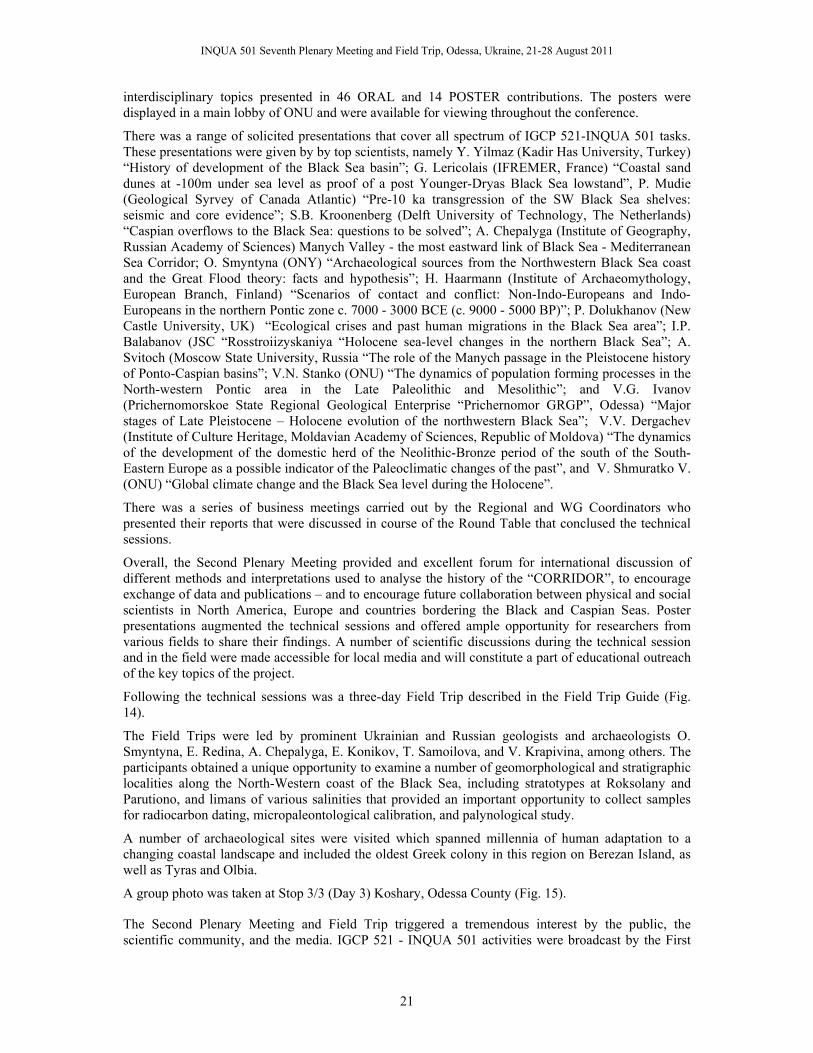
INQUA 501 Seventh Plenary Meeting and Field Trip, Odessa, Ukraine, 21-28 August 2011
21
interdisciplinary topics presented in 46 ORAL and 14 POSTER contributions. The posters were displayed in a main lobby of ONU and were available for viewing throughout the conference.
There was a range of solicited presentations that cover all spectrum of IGCP 521-INQUA 501 tasks. These presentations were given by by top scientists, namely Y. Yilmaz (Kadir Has University, Turkey) “History of development of the Black Sea basin”; G. Lericolais (IFREMER, France) “Coastal sand dunes at -100m under sea level as proof of a post Younger-Dryas Black Sea lowstand”, P. Mudie (Geological Syrvey of Canada Atlantic) “Pre-10 ka transgression of the SW Black Sea shelves: seismic and core evidence”; S.B. Kroonenberg (Delft University of Technology, The Netherlands) “Caspian overflows to the Black Sea: questions to be solved”; A. Chepalyga (Institute of Geography, Russian Academy of Sciences) Manych Valley - the most eastward link of Black Sea - Mediterranean Sea Corridor; O. Smyntyna (ONY) “Archaeological sources from the Northwestern Black Sea coast and the Great Flood theory: facts and hypothesis”; H. Haarmann (Institute of Archaeomythology, European Branch, Finland) “Scenarios of contact and conflict: Non-Indo-Europeans and Indo-Europeans in the northern Pontic zone c. 7000 - 3000 BCE (c. 9000 - 5000 BP)”; P. Dolukhanov (New Castle University, UK) “Ecological crises and past human migrations in the Black Sea area”; I.P. Balabanov (JSC “Rosstroiizyskaniya “Holocene sea-level changes in the northern Black Sea”; A. Svitoch (Moscow State University, Russia “The role of the Manych passage in the Pleistocene history of Ponto-Caspian basins”; V.N. Stanko (ONU) “The dynamics of population forming processes in the North-western Pontic area in the Late Paleolithic and Mesolithic”; and V.G. Ivanov (Prichernomorskoe State Regional Geological Enterprise “Prichernomor GRGP”, Odessa) “Major stages of Late Pleistocene – Holocene evolution of the northwestern Black Sea”; V.V. Dergachev (Institute of Culture Heritage, Moldavian Academy of Sciences, Republic of Moldova) “The dynamics of the development of the domestic herd of the Neolithic-Bronze period of the south of the South-Eastern Europe as a possible indicator of the Paleoclimatic changes of the past”, and V. Shmuratko V. (ONU) “Global climate change and the Black Sea level during the Holocene”.
There was a series of business meetings carried out by the Regional and WG Coordinators who presented their reports that were discussed in course of the Round Table that conclused the technical sessions.
Overall, the Second Plenary Meeting provided and excellent forum for international discussion of different methods and interpretations used to analyse the history of the “CORRIDOR”, to encourage exchange of data and publications – and to encourage future collaboration between physical and social scientists in North America, Europe and countries bordering the Black and Caspian Seas. Poster presentations augmented the technical sessions and offered ample opportunity for researchers from various fields to share their findings. A number of scientific discussions during the technical session and in the field were made accessible for local media and will constitute a part of educational outreach of the key topics of the project.
Following the technical sessions was a three-day Field Trip described in the Field Trip Guide (Fig. 14).
The Field Trips were led by prominent Ukrainian and Russian geologists and archaeologists O. Smyntyna, E. Redina, A. Chepalyga, E. Konikov, T. Samoilova, and V. Krapivina, among others. The participants obtained a unique opportunity to examine a number of geomorphological and stratigraphic localities along the North-Western coast of the Black Sea, including stratotypes at Roksolany and Parutiono, and limans of various salinities that provided an important opportunity to collect samples for radiocarbon dating, micropaleontological calibration, and palynological study.
A number of archaeological sites were visited which spanned millennia of human adaptation to a changing coastal landscape and included the oldest Greek colony in this region on Berezan Island, as well as Tyras and Olbia.
A group photo was taken at Stop 3/3 (Day 3) Koshary, Odessa County (Fig. 15).
The Second Plenary Meeting and Field Trip triggered a tremendous interest by the public, the scientific community, and the media. IGCP 521 - INQUA 501 activities were broadcast by the First

INQUA 501 Seventh Plenary Meeting and Field Trip, Odessa, Ukraine, 21-28 August 2011
22
Ukrainian Channel as well as by six local channels and a series of publications in periodicals for the mass media.
Figure 14. Sketch of the 2006 Field Tip sites marked by empty circles with numbers (Yanko-Hombach et al., 2006b).
A series of video films devoted to professional descriptions of the most prominent archaeological and geological sites of the Ukrainian part of the Corridor have been produced. All together, it contributed to dissemination and popularization of IGCP 521 - INQUA 501 ideas, in particular, the preservation of human heritage by re-evaluating and clarifying existing archaeological questions to arrive at a better understanding of the human response to environmental change in order to improve human living conditions, sustainable development, and wise management of the Earth as a human habitat.
Figure 15. Group photo from the Second Plenary Meeting and Field Trip, Koshary, Odessa County, 2006.
Moreover, the Second Plenary Meeting and Field Trip formed a platform for young undergraduate and postgraduate students to benefit from international exposure and interaction with scientists from different parts of the world and varied specialties. The students were trained to present their main achievements and to use discussion in order to defend their observations. Such experience can be exemplified by the excellent talk given in perfect English by M. Gladyrevska (supervised by Prof. Gerasimenko), National Taras Shevchenko University of Kyiv, Ukraine. Ms. Gladyrevska presented a summary of her thesis “The database of geoarchaeological sites of the Northern Black Sea area.”
The Second Plenary Meeting encouraged students to take new educational courses related to IGCP 521 - INQUA 501 topics, and to start working with a multidisciplinary approach that was intensely discussed during the conference. For example, after this meeting, a few students from Odessa I.I. Mechnikov National University decided to start working on their thesis. A. Seplyarskaya (Department
INQUA 501 Seventh Plenary Meeting and Field Trip, Odessa, Ukraine, 21-28 August 2011
23
of Archaeology and Ethnology) started her PhD thesis “Black Sea as geographic agency in historical and cultural process on the Northwestern Black Sea coast in prehistory,” while I. Zolotarenko decided to make her MSc thesis on “Environmental interpretation of subsistence strategy of Early Mesolithic populations of Steppe Ukraine.” Both theses were undertaken under supervision by Prof. O. Smyntyna.
Moreover, this meeting exposed the younger generation to the organization of meetings and field trips. About 50 students from Russia, Ukraine, and Moldova actively participated in the organizational work, thus, acquiring experience in developing their managerial skills and abilities in order to cultivate traditions of “European style” scientific fora as well as scientific discussion and informal meetings. This also promoted their interest in chosen specialties and motivated them to learn foreign languages in order to improve communication skills with western colleagues. A group of students from Russia, Ukraine, and Moldova under the supervision of Prof. Chepalyga made an excellent preparation of the type locality (stratotype) Roksolany “Loess-paleosol formation of Ukraine” for presentation to IGCP 521 participants during the Field Trip in Ukraine. Another group headed by Prof. Konikov discovered a new Holocene terrace on the northwestern coast of the Black Sea in the course of preparing an outcrop for the field trip.
This meeting strongly promoted a multidisciplinary approach in paleoenvironmental studies, which motivated students in geology to take archaeological courses and vice versa. This stimulated teachers to modify their courses (e.g., Geology and minerals of the Black Sea; Environmental Micropaleonology; Quaternary Geology given at Odessa I.I. Mechnikov National University; General Climatology and Theory of Climate given at M.V. Lomonosov Moscow State University).
Furthermore, the Second Plenary Meeting promoted the establishment of direct contacts between western and eastern youth, creating the background for better understanding of modern priorities in the developing world of science and humanities. It also exposed the younger generation in developing countries to new analytical techniques and state-of-the-art data interpretation in the field of sustainable development and environmental risk protection, as well as human cultural development. The Second Plenary Meeting and Field Trip encouraged collaboration between eastern and western scientists enabling them to exchange their opinions. It also gave an opportunity to western scientists to familiarize themselves with a vast amount of published and stored information in archives, scientific reports, maps, and collections largely unknown in the west and unavailable in most Western libraries and museums. They also provided a venue for microscope workshops to standardize micropaleontological and palynological processing methods and identifications, including exchange of reference material.
Based on the results of the Second Plenary Meeting and Field Trip in Odessa, and having a brilliant opportunity to improve the effectiveness of collaboration between archaeologists and marine geologists, it was decided to open an Interdisciplinary Coordination Scientific and Educational Center of Geoarchaeology, Marine and Environmental Geology (SECGMEG). This was established in 2007 and took a leading role in the organization of the concluding Seventh Plenary Conference and Field Trip in 2011.
It was decided (1) to run the next conference in Gelendzhik-Kerch (2007) with the main focus on the Kerch-Taman peninsula and Caucasus shoreline of the Black Sea; and (2) to publish materials of the Second Conference in the Second Special Volume of Quaternary International Journal.
3.3.3. The Third Plenary Meeting and Field Trip The Third Plenary Meeting and Field Trip was carried out jointly with the IGCP481 Fifth Plenary Conference. It was hosted by the Southern Branch of the P.P. Shirshov Institute of Oceanology in the beautiful Hotel “Sosnovaya Roscha” at Gelendzhik, and by the Beneficent Foundation “Demetra” at the rustic Hotel “Nymphey” on the shore of the Black Sea at Kerch, in the shadow of the ancient Greek town of Nymphaeum. This meeting was carried out on 8-15 in Gelendzhik, Russia, and 16, 17 September 2007 in Kerch, Ukraine.
Financial support for this meeting was contributed by IGCP 521 (6000 USD), IGCP 481 (5000 USD), INQUA 501 (6000 USD), Russian Foundation for Fundamental Research - RFFR (about 15000 USD)

INQUA 501 Seventh Plenary Meeting and Field Trip, Odessa, Ukraine, 21-28 August 2011
24
and Avalon Institute of Applied Sciences (5000 USD in kind), and Canadian Branch of IGCP (1100 CND). IGCP, INQUA and RFFR funds were used to cover travel expenses, accommodation and registration fee of 70 scientists from developing countries as well as local transportation and busses during the Field Trips.
President of the conference was Dr. Alexander POKRYSHKIN. Executive Director was Prof. Valentina Yanko-Hombach.
The meeting was attended by 81 intredisciplinary scientists from 13 countries. The Abstract Volume for the Third Plenary Meeting contained 77 extended abstracts (178 pages) written by 167 scientists from 20 countries (Fig. 16, 17).
Figure 16. Cover page of the 2007 Abstract Volume (Yanko-Hombach et al., 2007c). ISBN 978-5-85941-151-0.
Figure 17. Number of countries and contributors to the 2007 Abstract Volume.
Figure 18. Cover page of the 2007 Field Trip Guide (Yanko-Hombach et al., 2007d). ISBN 978-5-85941-153-5.
The conference began on 8 September with Registration and welcoming Icebreaking Cocktail at Hotel “Sosnovaya Roscha” to celebrate the arrival of participants who travelled by bus and ferry from Odessa, and others who came by plane from Anapa north of Gelendzhik. The bus journey was documented in film, and thanks to Ken Wallace, co-leader of WG12, it can be viewed by all at www.black.sealevel.ca. The 3-day Technical Program (9-11 September) began with an introduction to the IGCP 521-INQUA 501-IGCP 481 by Chairman Yucel Yilmaz (Turkey), greetings from the Conference President Alexander Pokryshkin, and reports on the current state of knowledge for IGCP 521-INQUA 501 and IGCP 481 by Valentina Yanko-Hombach and Salomon Kroonenberg, respectively.
The technical program was structured in four Panels:
Panel 1 “Palaeogeographic and Palaeoceanographic reconstructions” included four sessions - 1. Geology, Palaeoceanography and Palaeogeography; Session 2. Palaeontology and Stratigraphy; Session 3. Palynology; Session 4. Active Tectonics.
Panel 2 “Archaeology, History, and Ethnology”.
Panel 3 “GIS-linked Mathematical and Geological Modeling”.
Panel 4 “Geo-Information System “.
A number of technical sessions within these Panels contained a wide spectrum of interdisciplinary topics presented in 61 ORAL and 21 POSTER contributions. The posters were displayed in the Conference Room during all duration of the conference. Their subjects ranging from the impact of pollution on the morphology of Black Sea ostracods and foraminifera to water level changes in the Caspian Sea. The poster presentations were viewed and discussed by an informal round table group of about 20 scientists.
The first day of technical sessions was devoted to 11 reports on the Geology, Paleoceanography and Paleogeography, with a keynote address by A. Panin (Russia) on the importance of river runoff into the Black and Caspian Seas at the end of OIS-2. This keynote paper was followed by reports by

INQUA 501 Seventh Plenary Meeting and Field Trip, Odessa, Ukraine, 21-28 August 2011
25
Russians and Ukrainians that led to heated discussions regarding mechanisms to account for local irregularities in Holocene transgressive-regressive cycles found by different workers. The afternoon was devoted to 6 palynology papers, given by scientists from five different nations and covering the Black and Caspian Seas, as well as limans and lakes in the Crimea.
Over the next two days, 50 technical papers were delivered, covering a wide spectrum of other interdisciplinary topics during conference sessions. Keynote addresses were delivered by Salomon Kroonenberg (Delft University of Technology, The Netherlands), who spoke on Caspian Sea level change and its link with the Black Sea; Y. Yilmaz (Kadir Has University, Istanbul) explained the tectonic and morphological development of the eastern Black Sea-Caspian region; G. Sarson (New Castle University, UK) presented a very thought-provoking model on human migration and the spread of agriculture from multiple centers in the Neolithic; R. Martin (University of Delaware, USA) spoke on multiple marine excursions as related to freshwater discharge events; P. Dulakanov (Newcastle University, UK) on human migration and settlement in the northern Black Sea and Caspian areas; and Ken Wallace (Sealevel Communications, Canada) presented an online template for interactive data entry for IGCP 521-INQUA 501 collaboration, that was subsequently also adopted the database resource for IGCP 481.
In keeping with the tradition of IGCP meetings, field trips followed the technical sessions and were described in the Field Trip Guide (Fig. 18; Yanko-Hombach et al., 2007d). Field Trip sites are shown in Fig. 19.
Figure 19. Sketch of the 2007 Field Tip sites marked by empty circles with numbers (Yanko-Hombach, 2007d).
This year, there was a record number of 3 days in southern Russia and 2 days in the eastern Crimea. The first day included visits to the Old Euxinian/Krinitsian (early Pleistocene) terrace in the Vulan-Pashada interfluve, to the megalithic dolmens (Bronze Age, 4,000-3,500 yrs BCE ) near Pashada village (below left), and an afternoon of cruising along the Caucasian Black Sea coast in the “Salamandra”, where stunningly beautiful sections of late Cretaceous-Paleogene flysche sequences are exposed and we had perhaps the last view of the lower Pleistocene Chaudian terrace reference section at Idukonopas Cape (below right), where a resort is under construction for the Russian President. In addition, we all got a chance to swim in the Black Sea by diving off the boat. This first day field trip was led Russian geologists Y. Ismailov and N. Esin, and an archaeologist from Pshada.
The second day of field trips took us to the archaeological museums at Anapa and Taman where we viewed the excavation of the ancient Greek city of Gorgippia (below left) and the Hermonassa-Tmutarkan historical-archaeological site, close to the impressive 17th century monument dedicated to the first Taman Cossacks. We journeyed over the Taman Peninsula, crossing the Kuban River paleochannel and past Volna village (where coastal erosion presently exceeds 1m/year) to the Tuzla Spit where we could view the marine Karangatian (OIS Stage 5a) sediments dated ca. 80,000 yr BP (below right). Here Yakub Izmailov, Andrei Chepalyga and Valentina Yanko-Hombach gave us

INQUA 501 Seventh Plenary Meeting and Field Trip, Odessa, Ukraine, 21-28 August 2011
26
detailed explanations of the paleoecology: sea level was 8 m higher than now and the shelf water salinity was about 30 ‰ compared to the modern value of about 18 ‰.
The third day of field trips took us first to the unique region of mud volcanoes near the town of Temryuk (left below) in the Kerch-Taman region where there are more than 50 mud volcanoes, including continental and marine, active and inactive types. We then visited the mid 6th BCE archaeological site at Phanagorea (below right) that once occupied 65 ha during a time when sea level may have been 4-5 m lower than now, and survived until the 10th century CE. During its classical period in the 4th century BCE, there were large public buildings, marble statues and evidence of trade of foods and religious materials from the Mediterranean. The long fieldtrip day ended with a midnight ferry crossing from Russia to the Ukraine and an early morning supper at the Hotel Nymphey in Kerch.
The last two days of Field Trips were spent in the vicinity of Kerch, visiting the Museum of Antiquities (one of the oldest in the Ukraine) and its amazing collection of Scythian and Grecian gold artifacts, the Tsarsky kurgan (below left), excavations of Late Bronze Age fishing and winemaking facilities at Tiritaka/Diya, and the excavations of the ancient Greek town of Nymphaeum that may have been overwhelmed during the youngest (Nymphaean) marine transgression. The final day was spent exploring the Karangatian (OIS 5e) neostratotype near Eltigen on the Kerch Strait, under the guidance of A. Chepalyga and V. Yanko-Hombach. There we were also able to view to early Late Miocene Sarmartian lagoonal clays. The field trip ended with a conference dinner provided by the Hotel Nymphey and a football contest between the Ukraine, Canada, Turkey and Iran in the attractive garden of the hotel.
The group photo (Fig. 20) was taken at the Hotel “Sosnovaya Roscha” by the end of the conference.
Figure 20. Group photo from the Third Plenary Meeting and Field Trip, Hotel “Sosnovaya Rosha”, Gelendzhik, Russia, 2007.
The meeting provided a forum for a global community of scientists from four continents. Special attention was paid to the link between the Black Sea and the Caspian Sea via the Manych Outlet, north of the Caucasus. It is assumed that at the last Pleistocene (Khvalynian) highstand of around +50 m (CSL is now at –27 m), overflow from the Caspian to the Black Sea occurred through the Manych strait. However, the age of this overflow is disputed: some claim it is Early Glacial (70 ka BP), others Late Glacial, as late as 13 ka BP. This is a very important issue for the Black Sea as well, in view of the raging controversy about whether or not a huge flood occurred in the Early Holocene when postglacial sea-level rise in the Mediterranean intruded into the Black Sea.
It was decided (1) to run the next conferences in Romania-Bulgaria (2008) with a main focus on the Romanian part of the Danube delta and the Northern and Southern Bulgarian coast of the Black Sea; and (2) to publish materials of the Second Conference in the Third Special Volume of Quaternary International Journal.

INQUA 501 Seventh Plenary Meeting and Field Trip, Odessa, Ukraine, 21-28 August 2011
27
3.3.4. The Fourth Plenary Meeting and Field Trip The Fourth Plenary Meeting and Field Trip was organized jointly by the National Institute of Marine Geology and Geoecology (GeoEcoMar), Bucharest, Romania, the Department of Natural History of the Regional Historical Museum, Varna, Bulgaria, the Avalon Institute of Applied Science, and EC FR 6 HERMES project, on 4-16 October 2008.
Financial support for this meeting was contributed by IGCP 521 (8000 USD), INQUA 501, the National Institute of Marine Geology and Geoecology [GeoEcoMar] (20000 euro) including 9000 USD from the National Council of Research, and 11,000 USD from the National Plan of Research and Development, Romania (obtained by Dr. Melinte), 5000 USD (in-kind) from the Avalon Institute of Applied Science, and 1100 CND from the Canadian Branch of IGCP Few scientists from Australia (A. Chivas and N. Nicholas) and UK (P. Dolukhanov) were supported by local branches of IGCP for their travel to Romania and Bulgaria. .
Co-Presidents of the conference were Prof. Nicolae Panin (Vice-President Dr. Mihaela Melinte) and Dr. Mariana Filipova-Marinova, respectively. Executive Director was Prof. Valentina Yanko-Hombach.
One hundred sixty seven scientists from four continents and 18 countries contributed to the conference; 63% of them were from developing countries (Fig.21). Their peer-reviewed contributions are assembled in a 186-page volume that contains 78 extended abstracts (Fig. 20).
The meeting began on October 4 with registration and a welcoming icebreaker at the EURO Hotel, Bucharest, to celebrate the arrival of participants who travelled from over the world to Romania.
The meeting discussed the actual status of our knowledge on a range of subjects as well as scientific approaches to integrating environmental, anthropological, ethnological, and archaeological data in order to trace the history of ancient humans in the region and to predict their future development in coastal zones under various sea-level scenarios. It also introduced young scientists, especially from the Eastern countries, to new analytical techniques and state-of-the-art interpretation of data. Besides, it encouraged east-west dialogue and integrated researchers from different countries into the international R&D community, and contributed to the preservation of cultural and religious heritage through the discussion of ancient cultures, civilizations, and their legends.
The 3-day technical program (October 5–7) started with greetings from Prof. Anton Anton, Minister of the Romanian Ministry of Education and Research, and Conference Co-Presidents Prof. Nicolae Panin and Dr. Mariana Filipova-Marinova. It was followed by the progress report presented by Prof. Valentina Yanko-Hombach, on the current status of both projects and the need for future research and collaboration.
Figure 20. Cover page of the 2008 Abstract Volume (Gilbert and Yanko-Hombach, 2008). ISBN 978-973-0-06271-7.
Figure 21. Number of countries and contributors to the 2008 Abstract Volume.
Figure 22. Cover page of the 2008 Field Trip Guide (Poenaru and Briceag, 2008). ISBN 978-973-0-06270-0.
The Technical Sessions were organized into four panels and eight Oral and Poster sessions.

INQUA 501 Seventh Plenary Meeting and Field Trip, Odessa, Ukraine, 21-28 August 2011
28
Panel 1 “Paleogeographic and Paleoceanographic Reconstructions” included sessions: “Geology, Paleoceanography, and Paleogeography of the Caspian-Black Sea-Mediterranean Corridor”, “Paleontology and Biostratigraphy”, “Active Tectonics”, and “Palynology”.
Panel 2”GIS-linked Mathematical and Geological Modeling included one session “GIS-linked Mathematical and Geological Modeling”.
Panel 3 “Archaeology, History, and Ethnology” included session “Archaeology, History, and Ethnology of the Caspian-Black Sea-Mediterranean Corridor”.
Panel 4 “Hot Spot Ecosystems of the Black Sea included session “Hot Spot Ecosystems”.
Forty five oral and thirteen poster presentations including three keynote talks were delivered. Presentations focused primarily on either archaeology or coastal geoscience. Prof. Allan Chivas, president of INQUA, and his PhD student Antony Niholas on behalf of their Australian and Ukrainian collaborators gave a key-note talk on aminostratigraphy of coastal sedimentary sequences, Kerch Strait, northeastern Black Sea. Dr. Mariana Filipova-Marinova presented her achievements on palynostratigraphy of Pleistocene and Holocene sediments from the western Black Sea. Prof. Pavel Dolukhanov on behalf of his Ukrainian and Russian collaborators presented new information on “Black and Caspian Seas in Early-Mid-Holocene: climate, sea levels and the spread of Neolithic” and “Black Sea and Caspian Basins in Late Pleistocene: sea-level changes, climate and early human settlement”.
New work of G. Lericolais, France, indicated that there was a significant influx of Mediterranean water into the Black Sea at approximately 8.4 ka (14C yr). Other presentations included those on Caspian sea-level fluctuations, palynostratigraphy of the western Black Sea, sedimentary relationships between the Carpathians and the Black Sea basin, and tectonics of the North Anatolian Fault for example. In contrast, Dr. Ivar Murdmaa and collaborators from Russia described the first submersible examination of the Gibraltar Sill by Russian workers in 1995.
A hot discussion took place on October 7, the last day of the technical sessions. The main topics of the discussion included (1) the beginning of first intrusion of the Mediterranean waters into the Black Sea in Holocene as well as the speed of Holocene transgression (catastrophic versus gradual and/or oscillating), and (2) radiocarbon dating by conventional and AMS methods.
It was decided (1) to run the next conferences in Turkey (2009) with main focus on the Aegean/Eastern Mediterranean and Caspian shoreline, respectively; (2) to publish materials of the Fourth Conference in the special volume of Quaternary International Journal; and (3) as the main product of the projects to prepare a collective monograph concentrating on the most contradictive questions in geosciences and archaeology of the “CORRIDOR”.
The Technical Sessions were followed by the Field Trips described in the Field Trip Guide (Fig. 22). The eight-days (8-14 October, 2008) Field Trip (by bus and boat) led by prominent Romanian and Bulgarian geologists and archaeologists, including conference Co-Leaders, N. Panin and M. Filipova-Marinova, as well as P. Mihova, M. Daskalov, D. Pavlov, T. Dimov, K. Stoykova, and V. Tenekedziev, among others. The participants had an opportunity to examine a number of geomorphological, stratigraphic, and archaeological localities along the Danube Delta and western coast of the Black Sea, including coastal dunes, the free-meandering St. George branch of the Danube River, the meeting point of the Danube River and the Black Sea, and a very wide 10-km-long beach with small to medium size dunes formed by sand of Danubian origin containing a unique mixture of mollusk shells represented by freshwater (Unio), brackish (Monodacna), and marine (Cardium, Rapana) species that provided an important opportunity to obtain samples for radiocarbon dating, isotopic and micropaleontological calibration. In addition, visits were made to a number of archaeological sites, which spanned several millennia of human adaptation to a changing coastal landscape. On the Romanian coast, sites included Histria fortress (Fig. 23), the first Greek settlement on the western coast of the Black Sea.
On the northern Bulgarian coast, sites included the archaeological park of Durankulak and the museum at Durankulak, Shabla lake (paleoecological reconstructions and human activities for the last 7 kyrs),

INQUA 501 Seventh Plenary Meeting and Field Trip, Odessa, Ukraine, 21-28 August 2011
29
Cape Kaliakra, and Cretaceous-Tertiary (K/T) boundary in marine sediments. On the southern Bulgarian coast, the tour included Sozopol, the oldest town on the Bulgarian Black Sea coast (dated to the 4th–3rd millennia BC); archaeological artifacts of the Late Eneolithic and Early Bronze Age settlements exhibited at the archaeological museums in Sozopol and Kiten, the stone forest near Varna where a grpup picture photo was taken (Fig. 24), and the archaeological Museum in Varna, famous for the oldest gold in the world. This museum hosts more than 100,000 objects–monuments of past eras from Varna, the Region of Varna, and Northeastern Bulgaria. The meeting was completed by cocktail party from the Director of the Museum of Natural History in Varna on October 15, 2008.
Figure 23. Sketch of the 2008 Field Tip sites (Poenaru and Briceag, 2008).
It was decided (1) to run the next conferences in Turkey in 2009 with main focus on the Aegean and Eastern Mediterranean coast); and (2) to publish materials of the Fourth Conference in the Four Special Volume of Quaternary International Journal.
Figure 24. Group photo from the Third Plenary Meeting and Field Trip, stone forest near Varna , Bulgaria, 2008.

INQUA 501 Seventh Plenary Meeting and Field Trip, Odessa, Ukraine, 21-28 August 2011
30
3.3.5. The Fifth Plenary Meeting and Field Trip The Fifth Plenary Meeting and Field Trip was organized jointly by the Dokuz Eylül University, İzmir, Turkey; Çanakkale Onsekiz Mart University, Çanakkale; Kadir Has University, Istanbul; and the Avalon Institute of Applied Science on 22–31 August 2009.
Financial support for this meeting was contributed by IGCP (10,000 USD), from INQUA (6000 USD), the Avalon Institute of Applied Science (5000 USD), and various Turkish agencies, which provided mostly in-kind contributions (about 15,000 USD). Transportation costs in Turkey by two conference buses were partially covered from IGCP funds. Besides, IGCP funds covered registration fees for a number of scientists, contributing to their lodging, conference kits, etc., as well as lunch boxes for three field trips. INQUA funds were used for expenses similarly to those of IGCP 521. The Turkish funds covered hotel accommodations for some participants as well as printing of the conference materials (Abstract Volume, Field Trip Guide, and Conference Program). Other expenses (e.g., fax, telephone, post, Internet, website, etc. were covered largely by the Avalon Institute of Applied Science.
President of the conference was Prof. Yücel Yılmaz. Executive Director was Prof. Valentina Yanko-Hombach.
One hundred ninety one scientists from four continents and 18 countries contributed to the conference; 86% of them were from developing countries (Fig. 26). Their peer-reviewed contributions are assembled in a 191-page volume that contains 81 extended abstracts (Fig. 25).
Figure 25. Cover page of the 2009 Abstract Volume (Gilbert and Yanko-Hombach, 2009). ISBN 978-975-441-265-9.
Figure 26. Number of countries and contributors to the 2009 Abstract Volume.
Figure 27. Cover page of the 2009 Field Trip Guide (Helvaci et al., 2009). ISBN 978-975-441-264-2.
The meeting began on August 22 with registration and a welcoming icebreaker at the Social Centre, Second Floor, Dokuz Eylül University, Çanakkale, to celebrate the arrival of participants who travelled from over the world to Turkey.
The Fifth Plenary Meeting and Field Trip focused on the progress of IGCP 521 - INQUA 501 with special attention to (1) Linear and non-linear geological processes and concepts through correlative studies of a wide range of sites through the “Corridor” that is needed to achieve a better understanding of the influence of global climate change and/or active tectonics on regional sea-level fluctuations, coastline evolution, transformation from lacustrine to marine environment, eco- and sedimentary systems (including deposition of sapropels), as well as prehistory and history of the adaptation of Anatomically Modern Humans; (2) Correlation of sea-level changes in the “Corridor” with those in the Caspian Sea; (3) Improvement of standards of research methods and techniques (e.g., quantitative modeling of environmental crises with detailed identification of the factors involved and their behavior); (4) Delineation of the main areas of natural risk (e.g., erosion, flooding) required for proper environmental management; and (4) Further elaboration of a complete database on bibliography, radiocarbon assays, archaeological sites, and artifacts linked to the sea-level changes.

INQUA 501 Seventh Plenary Meeting and Field Trip, Odessa, Ukraine, 21-28 August 2011
31
The 3-day technical program (23–25 August) started with greetings from Prof. Yücel Yılmaz. It was followed by the progress report presented by Prof. Valentina Yanko-Hombach, on the current status of both projects and the need for future research and collaboration.
The Technical Sessions were organized into three panels and eight Oral and Poster sessions.
Panel 1: “Paleogeographic and Paleoceanographic Reconstructions” included sessions: “Geology, Paleoceanography and Paleogeography”; “Active Tectonics”; “Paleontology and Biostratigraphy”; and “Palynology.”
Panel II: “Archaeology, History, and Ethnology” included the session “Archaeology, History, and Ethnology.”
Panel III: “Degassing of the Black Sea” included the session “Hot Spot Ecosystems.”
Fifty-seven oral and twenty-two poster presentations including two keynote talks were delivered. Presentations focused primarily on either archaeology or coastal geoscience. The keynote lecture “Active tectonics and the consequent morphology of the Western Anatolian-Aegean region” was given by Prof. Yılmaz, Turkey. Unfortunately, due to his illness, Prof. Dolukhanov, UK, cancelled his trip at the last moment. His keynote speech “Climate, Sea-level dynamics and human colonization of the Caspian and Black Sea coastal areas” was given on his behalf by Prof. Helmut Brückner, Germany.
The first day of technical sessions was devoted to 19 reports on Geology, Paleoceanography, and Paleogeography, with a keynote address by Y. Yılmaz (Turkey) on the active tectonics and the consequent morphology of the Western Anatolian-Aegean region. In his lecture, he demonstrated that during the last few thousand years, the western Anatolian coastal zones have passed through severe changes due mainly to the effects of the ongoing tectonics. The extensional-induced elevation of the horst has led to increasing amounts of erosional debris, transported by the major rivers, emplaced within these graben depressions, moved to the Aegean Sea, and accumulated in the alluvial plains where they caused retreat of the sea. Consequently, the antique coastal cities such as Miletus, Ephesus, and Troya have been left behind as inland areas, a long way away from the present seashore. The progressive changes of the coastline around these ancient towns were reviewed in his talk. O. Algan on behalf of five co-authors presented new data on the fan-delta system, which based on her opinion, is geologically a very young formation. This fan-delta was produced by a relatively fast and strong northerly flow from the Mediterranean into the subaerially exposed shelf area earlier than 7.8 ka BP, and there are still erosive evidences of the influence of this present-day Mediterranean lower layer along this system. W. Nicholas on behalf of six co-authors and based on amino acid racemization 14C accelerator mass spectrometry, confirmed that marine coastal sedimentary sequences at Eltigen and Cape Tuzla (Kerch-Taman Peninsula) were formed during MIS 5e, as was previously determined by U/Th dating (Dodonov et al., 2000) techniques. N. Panin gave a very interesting talk on the sediment sink processes within the Danube-Black Sea system. R. Martin presented data in support of the oscillating hypothesis of the Black Sea level change. According to his opinion, sea-level and climate change during the Pleistocene-Holocene transition may have been similar to that of the Holocene, but greatly amplified. As such, the reconnection of the Black Sea with the Mediterranean appears to have been more oscillatory than catastrophic. However, according to D. Kelterbaum, a major sea-level fluctuation of several meters cannot be traced in the northern Black Sea region, and so, the oscillatory model is wrong. Over the next two days, 38 talks were given. The keynote talk of P. Dolukhanov “Climate, sea-level dynamics and human colonization of the Caspian and Black Sea coastal areas” was given by H. Brückner because Pavel could not attend the meeting. This exiting talk demonstrated that the spread of Anatomically Modern Humans (AMS) and Upper Paleolithic technologies occurred under conditions of an environmental crisis related to the lowstand (~130 m below present) of the isolated brackish water Neoeuxinian basin during the Last Glacial Maximum (LGM), about 25–20 ka BP (MIS 3). The spread of agriculture in Europe and western Asia may be statistically approximated as a gradual expansion from the Levantine centre either enhanced or slowed by environmental factors creating bottlenecks. In the framework of the EU FR6 HERMES project, a group of scientists from Odessa I.I. Mechnikov National University presented their new achievements on the lithology, biochemistry, and micropaleontology of mud volcanoes and high-intensity cold seeps on the bottom of the Black Sea and Sea of Azov. Other presentations related to HERMES dealt with calcareous

INQUA 501 Seventh Plenary Meeting and Field Trip, Odessa, Ukraine, 21-28 August 2011
32
nannoplankton, ostracoda, foraminifera, meio- and macrobethos of the Black Sea presented by Romanian and Ukrainian scientists.
Poster presentations augmented the technical sessions and offered ample opportunity for researchers from various fields to share their findings. The posters were displayed at the Conference Hall of Çanakkale Onsekiz Mart University and were available for viewing throughout the conference.
A heated discussion took place on 24 August, the last day of the technical sessions. The main topics of the discussion included the accuracy of radiocarbon dating by conventional and AMS methods.
Following the Technical Session, a five-day Field Trip (Fig. 27, 28) was carried out, enabling participants to examine a number of geomorphological, stratigraphic, and archaeological localities along the Aegean coast. In addition, a number of archaeological sites were visited, which spanned millennia of human adaptation to a changing coastal landscape (Helvaci et al., 2009). The Field Trips were guided by prominent German (H. Brückner) and Turkish (Ilhan Kayan, Şükrü Tül, Ökmen Sümer, Yalçin Esroy) geologists and archaeologists. The Field Trip sites are shown in Fig. 28. The Field Trip was split into two parts: Izmir and Çanakkale.
Figure 28. Sketch of the 2009 Field Tip (Helvaci et al., 2009).
The Izmir part included Tour 1 and 2 and was carried out on 26 and 27 August, respectively.
Tour 1. Coastal changes and historical background: Ephesus. During this tour participants had a chance to observe: a panoramic view of Selçuk plain; sea-level change reflected in early building phases at Artemision; Olympieion and earthquake debris filled grounds of a Hadrianic temple in Ephesus; silt filled ancient harbour of Ephesus; Selçuk depression where a trip to the ancient Ephesian gulf, Syrie island (today Kurudağ), Akgöl, Gebekirse, and Alaman lakes was undertakenRoman age human made silt deposits of ancient Ephesos harbour.
Tour 2. Coastal changes and historical background: Miletus. In course of this tour participants had a chance to observe: Ancient river bed of Maindros and over it: Ramazan Paşa Bridge; Historical battle ground of Lade island, recorded by Herodotus; today a hill on the Söke plain; Panaromic view from Miletus theatre hill; Prehistoric island, eyewitness of Minoan eruption; Didyma Appolon temple and visit; ancient Latmian harbour, today Bafa lake and Azap lake; and ancient Myus’s harbour.
The Çanakkale part included Tour 3 , 4 and 5 and was carried out on 28, 29 and 30 August, respectively.
Tour 3. Troy and Alexandria Troas included observation of the granite Quarries of Kestanbol; Alexandria Troia; and Troia. On this stop a group picture was taken (Fig. 29).
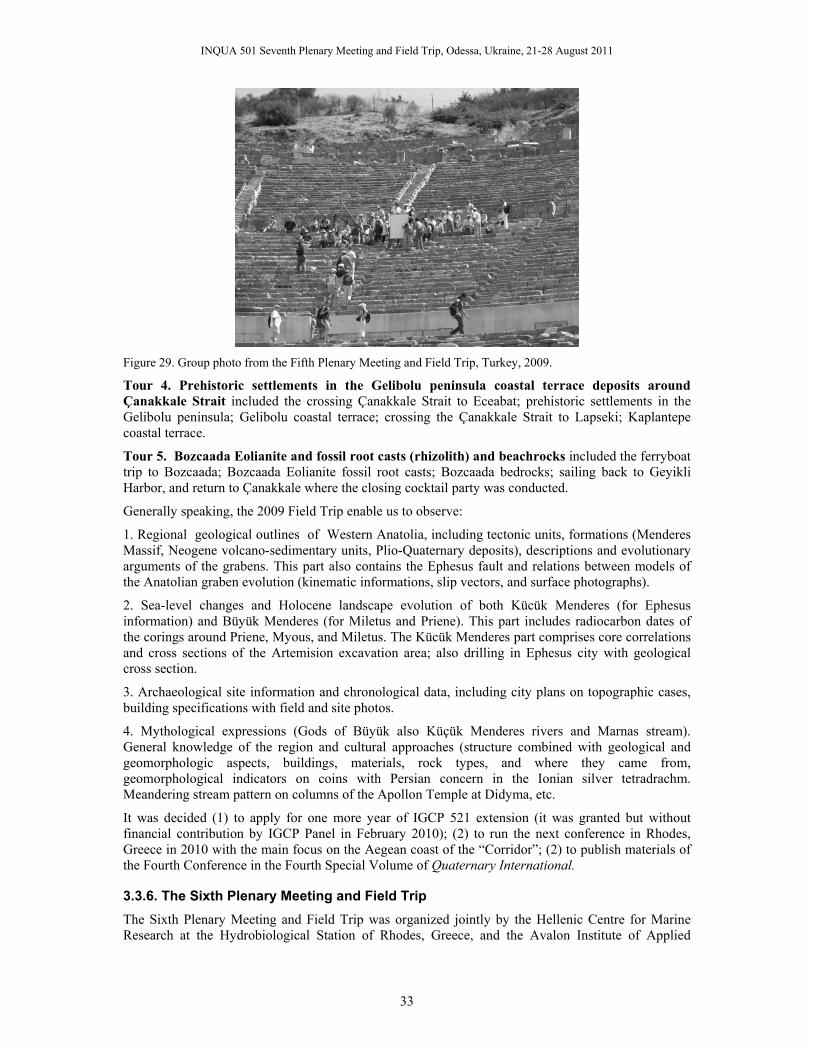
INQUA 501 Seventh Plenary Meeting and Field Trip, Odessa, Ukraine, 21-28 August 2011
33
Figure 29. Group photo from the Fifth Plenary Meeting and Field Trip, Turkey, 2009.
Tour 4. Prehistoric settlements in the Gelibolu peninsula coastal terrace deposits around Çanakkale Strait included the crossing Çanakkale Strait to Eceabat; prehistoric settlements in the Gelibolu peninsula; Gelibolu coastal terrace; crossing the Çanakkale Strait to Lapseki; Kaplantepe coastal terrace.
Tour 5. Bozcaada Eolianite and fossil root casts (rhizolith) and beachrocks included the ferryboat trip to Bozcaada; Bozcaada Eolianite fossil root casts; Bozcaada bedrocks; sailing back to Geyikli Harbor, and return to Çanakkale where the closing cocktail party was conducted.
Generally speaking, the 2009 Field Trip enable us to observe:
1. Regional geological outlines of Western Anatolia, including tectonic units, formations (Menderes Massif, Neogene volcano-sedimentary units, Plio-Quaternary deposits), descriptions and evolutionary arguments of the grabens. This part also contains the Ephesus fault and relations between models of the Anatolian graben evolution (kinematic informations, slip vectors, and surface photographs).
2. Sea-level changes and Holocene landscape evolution of both Kücük Menderes (for Ephesus information) and Büyük Menderes (for Miletus and Priene). This part includes radiocarbon dates of the corings around Priene, Myous, and Miletus. The Kücük Menderes part comprises core correlations and cross sections of the Artemision excavation area; also drilling in Ephesus city with geological cross section.
3. Archaeological site information and chronological data, including city plans on topographic cases, building specifications with field and site photos.
4. Mythological expressions (Gods of Büyük also Küçük Menderes rivers and Marnas stream). General knowledge of the region and cultural approaches (structure combined with geological and geomorphologic aspects, buildings, materials, rock types, and where they came from, geomorphological indicators on coins with Persian concern in the Ionian silver tetradrachm. Meandering stream pattern on columns of the Apollon Temple at Didyma, etc.
It was decided (1) to apply for one more year of IGCP 521 extension (it was granted but without financial contribution by IGCP Panel in February 2010); (2) to run the next conference in Rhodes, Greece in 2010 with the main focus on the Aegean coast of the “Corridor”; (2) to publish materials of the Fourth Conference in the Fourth Special Volume of Quaternary International.
3.3.6. The Sixth Plenary Meeting and Field Trip The Sixth Plenary Meeting and Field Trip was organized jointly by the Hellenic Centre for Marine Research at the Hydrobiological Station of Rhodes, Greece, and the Avalon Institute of Applied

INQUA 501 Seventh Plenary Meeting and Field Trip, Odessa, Ukraine, 21-28 August 2011
34
Science on 27 September–5 October 2010. This conference was dedicated to Prof. Pavel Dolukhanov, who passed away on 6 December 2009.
Financial support for this meeting was contributed by INQUA (6000 USD), the Avalon Institute of Applied Science (5000 USD), and Greek organizers (at least 20,000 USD). INQUA funds were used to cover registration fees and, in select cases, accommodation of the scientists from developing countries. Other funds were used to cover transportation during field trips, printing of the Abstract Volume and Field Trip Guides, etc. We were extremely short in funds and thanks to the Greek organizers, we were able to run the Conference and Field Trip in the best possible way.
The President of the conference was Prof. Valentina Yanko-Hombach. The Chairman of the Organizing Committee was Dr. Dimitris Sakellariou.
One hundred eighty-one scientists from four continents and 16 countries contributed to the conference; 57% of them were from developing countries (Fig. 31). Their peer-reviewed contributions are assembled in a 235-page volume that contains 81 extended abstracts (Fig. 30).
The Technical Sessions began with the report of the IGCP 521-INQUA 501 activities provided by Prof. Valentina Yanko-Hombach who presented an overview of achievements in both projects. Over the next three days (28-30 September) it was followed by eight technical sessions with a wide spectrum of interdisciplinary topics presented in 57 ORAL and 25 POSTER contributions. The posters were displayed at the Second Floor of the Hellenic Centre for Marine Research at the Hydrobiological Station of Rhodes, Greece.
Key-note lectures were given by D. Sakellariou “Submerged cultural remains in long-term uplifting regions: examples from the Hellenic Arc”; Y. Yilmaz “A new look at the western Anatolia-Aegean morphotectonics”; and E.F. Shnyukov “Quaternary mud volcanism of the Azov-Black Sea basin, on shore and off shore” (presented by V. Yanko-Hombach).
Figure 30. Cover page of the 2010 Abstract Volume (Gilbert and Yanko-Hombach, 2009). ISBN 978-960-98054-7-6
Figure 31. Number of countries and contributors to the 2010 Abstract Volume.
Figure 32. Cover page of the 2010 Field Trip Guide (Sakellariou and Lukosis, 2010). ISBN 978-960-98054-8-3.
In his lecture D, Sakellariou provided an outlook of the Hellenic Arc, which has been since Plio-Quaternary the scene of significant deformation, caused by the underplating of the Eastern Mediterranean crust under the Aegean “microplate” or by the escape lateral tectonics, developed along it. Crustal movements created a complicated puzzle of tectonic blocks, which move more or less independently. Thus, tectonic uplift is evident on most regions along the Hellenic Arc, from West and South Peloponese, to Crete and Rhodes Island. A sequence of Pleistocene marine terraces uplifted to altitudes up to 400m along the eastern side of Rhodes indicates long-term uplift of the island. A number of up to 4-5m uplifted Late Holocene paleocoastlines have been mapped and dated mainly along the eastern coast of the island, indicating recent (short-term) vertical tectonic movements. Opposite to the apparently constant uplift of the island, remains of ancient slipways, belonging to shipsheds of the ancient harbor of Rhodes, and quarries of Roman age indicate local subsidence. In his

INQUA 501 Seventh Plenary Meeting and Field Trip, Odessa, Ukraine, 21-28 August 2011
35
lecture Y. Yilmaz talked about the Western Anatolian-Aegean extended terrain stretches from the Balkan region in the north to the Mediterranean Sea in the south. The terrain has the following 4 major geological components: the metamorpic massives, the magmatic associations, the Neogene cover rocks, and the N-S extensional regime. In his lecture he provided a review of the nature of these problems with the main attention given to the most active events: the development of the present morphology. E.F. Shnyukov provided the review of on- and off-shore mud volcanoes in the Black Sea. He showed that volcanoes in the Black Sea are quite abundant, relate to diapir tectonics, and their eruptions originate from Maikopian sediments as shown by foraminifera. A. Chepalyga presented his view for the high-resolution stratigraphy of the Late Quaternary based on Caspian and Black Sea level fluctuations. He convinced participants that more detailed stratigraphy is needed not only for geological mapping but for climatic and environmental reconstructions. The chronological background of the Final Pleistocene is very important because this is the time when productive economies and the earliest civilizations first appeared. V. Yanko-Hombach on behalf of four co-authors presented a talk “Was the Black Sea catastrophically flooded in the Early Holocene – a new perspective from the large-scale geological survey of the northwestern shelf “. She showed that the level of the brackish Neoeuxinian Lake was neither –120 mbsl (13.4–11.0 ka BP), nor was it –95 mbsl as suggested by the modified Flood Hypothesis. Instead it occurred at –37 and –20 mbsl, respectively. Exposed shelf areas along the coastline were swampy and prone to salinization, not favorable for arboriculture, agriculture, or animal husbandry. As such, no substantiated geologic evidence for catastrophic Early Holocene flooding exists, and there is no archaeological or palynological evidence for prehistoric occupation of the Black Sea shelves in water depths greater than –10 m near the modern coastline. G. Lericollais was not agree to these conclusions. According to his opinion, recent results obtained from pore water analyses suggest that the Black Sea was a freshwater lake prior to its reconnection with the Marmara Sea and enabling us to think that early Neolithic populations could have lived near the Black Sea lake and encountered the rise of the water when this water body reconnected with the Global Ocean. The dispute between these two groups of authors which goes on and on through all IGCP 521-INQUA 501 conferences , seems to be endless as both scientists and their groups are positive that they are right. The difference is that Yanko-Hombach et al. make their conclusions based on enormous amount of geological data across the Black Sea shelf while Lericollais et al. base their conclusions on the data obtained in restricted are of the Romanian shelf and continental slope.
By the end of the first day of Technical session a group picture was taken (Fig. 33).
Figure 33. Group photo from the Sixth Plenary Meeting and Field Trip, Rhodes, Greece.
The Technical Sessions were followed by the Field Trips described in 78-page colourful Field Trip Guide (Fig. 32). The Field Trip sites are shown in Fig. 34 a-c.

INQUA 501 Seventh Plenary Meeting and Field Trip, Odessa, Ukraine, 21-28 August 2011
36
a
b
c
Figure 34. Sketch of the 2010 Field Trips (Sakellariou et al., 2010).
The Field Trips were led by prominent Greek geologists and archaeologists: D. Sakellariou, Evi Nomikou, K. Baika, and S.Stiros.
The main goal of the Field Trips was to study the geodynamic regime of the Hellenic Arc; geology of Rhodes Island; active tectonics, seismicity, and paleo-shorelines; as well as obtain knowledge on Rhodes in prehistory and Greek mythology.
Field Trip No. 1 “Sea-level changes versus vertical tectonics of Rhodes Island” (Fig. 34a) was carried out on 1 October. In the course of this Field Trip, participants obtained an opportunity to visit sites of uplifted paleo-shorelines (Ladiko – “Anthony Queen’s beach,” Tsambika beach, etc.), uplifted marine terraces (Rhodes town, Faliraki, Lindos), coastal prograding sequences (Kalythies), active faults offsetting terraces (Lindos), sites of fossiliferous Pliocene marls, cold-water corals including Lophelia (Lardos), and many other sites of geological interest.
Field Trip No. 2 “The volcano of Nisyros Island” (Fig. 34b) was carried out on 2 October. The participants sailed from Rhodes to Mandraki, the main town of Nisyros, and then took a bus up the flanks of the volcano. As the next step, the participants entered the volcanic caldera and had the opportunity to walk on the bottom of the active craters, next to the fumaroles, and feel the earth boiling underneath their feet. After that, there was a lunch, after which participants sailed back to Rhodes.
Field Trip No. 3 “Archaeological sites of Rhodes” (Fig. 34c) provided an opportunity to familiarize participants with brief history of Rhodes; to visit the Akropolis of Lindos; Epta Piges; and Filerimos – ancient Ialyssos.
Acknowledgments Our sincere thanks are offered to Kadir Has University, Istanbul, Turkey; Odessa I.I. Mechnikov National University, Ukraine; the Southern Branch of the Institute of Oceanology, Russian Academy of Science, Gelendzhik, Russia; “Demetra Foundation,” Kerch, Ukraine; GeoEcoMar, Bucharest, Romania; the Department of Natural History of the Regional Historical Museum, Varna, Bulgaria; Dokuz Eylül University, Izmir, Turkey, and Çanakkale Onsekiz Mart University, Çanakkale Turkey, for their hospitality in hosting the IGCP 521 - INQUA 0501 First, Second, Third (together with IGCP 481), Fourth, Fifth, Sixth, and Seventh Plenary Meetings and Field Trips, respectively.
The Avalon Institute of Applied Science (AIAS), Canada, is gratefully acknowledged for its tremendous support in organizing and carrying out the project. We are indebted also to Dr. Irena Motnenko, Osorno Enterprise, Canada, for her extraordinary efforts in keeping the conference website updated.
We are indebted to all presidents of the conferences, Profs. Yücel Yılmaz, Olena Smyntyna, Alexander Pokryshkin, Nicolae Panin, and Mariana Filipova-Marinova, and the international support staff who made these meetings successful.

INQUA 501 Seventh Plenary Meeting and Field Trip, Odessa, Ukraine, 21-28 August 2011
37
We gratefully recognize the assistance of Prof. Allan Gilbert for editing and layout (together with Prof. Valentina Yanko-Hombach) of the Abstract Volumes, as well as of the team of local organizers for the Field Trip Guides. Prof. Pavel Dolukhanov and Dr. Ilya Buynevich are thanked for translating some abstracts from Russian into English.
We are very grateful to the journal Quaternary International, and Editor-in-Chief Prof. Norm Catto in particular, who has kindly invited us to publish IGCP 521 - INQUA 501 conference proceedings within its pages.
Financial contributions to underwrite the travel costs for scientists from developing countries and countries in transition were kindly provided by UNESCO-IUGS-IGCP, INQUA, INTAS, ESF (European Science Foundation), the Avalon Institute of Applied Sciences, and others. We also thank the British, Canadian and French IGCP Branches for support of scientists to attend the conferences. TÜBITAK, Turkey; Russian Foundation for Basic Research; Shell; the International Society of Environmental Micropaleonology, Microbiology and Meiobenthology; the Scientific-Research Association of the South-Russian Academy of Marine Technology, Ecology, and Medicine, Russia; and the Romanian Ministry of Education and Research are sincerely thanked for their financial contributions to the project.
We gratefully recognize the assistance of the Editorial Board (A. Gilbert, P. Dolukhanov, R. Martin, P. Mudie, and I. Buynevich) for constructive editing of the First, Second, Third, Fourth, Fifth, Sixth, and Seventh Abstract Volumes.
We are pleased to announce that the IGCP and INQUA Scientific Boards have recognized the project as a very successful one (see Part II).
Valentina Yanko-Hombach
References Aksu, A.E., Hiscott, R.N., Mudie, P.J., Rochon, A., Kaminski, M.A., Abrajano, T., and Yaflar, D.
2002. Persistent Holocene outflow from the Black Sea to the Eastern Mediterranean contradicts Noah's Flood hypothesis. GSA Today 12(5): 4–10.
Andrusov, N.I. 1884. Geologicheskie issledovaniia na Kerchenskom poluostrove, proizvedennie v 1882 i 1884 g.g. [Geological investigations on the Kerch Peninsula performed in 1882 and 1884]. Zapiski Novorossiiskogo obschestva ispyteteley prirodi [Messengers of the Novorossiisky Society of Naturalists] 9(2): 1-198. (In Russian)
Andrusov, N.I. 1890. Predvaritelnii otchet ob uchastii v Chernomorskoi glubokovodnoi ekspeditsii [Preliminary report about participation in the Black Sea geological expedition]. IRGO (Izvestiia Imp. Russkogo Geograficheskogo Obschestva) [News of the Geographical Society], A.V. Grigoriev, ed., v. 26. (In Russian)
Andrusov, N.I. 1918 Geologicheskoe stroenie dna Kerchenskogo proliva [Geological structure of the bottom of the Kerch Strait]. Izvestiia Akademii Nauk SSSR [News of the Academy of Sciences of the USSR], Seriia 6, 12(1):23–28. (In Russian)
Arkhangel’sky, A.D., and Strakhov N.M.. 1938. Geologicheskoe stroenie i istoria razvitia Chernogo moria (Geological structure and evolution of the Black Sea). Geolgicheskii institut Academii Nauk SSSR [Geological Institute of the USSR Academy of Sciences]. Moscow-Leningrad. (In Russian)
Avrametz, V.M., Kakaranza, S.D., Sibirchenko, M.G., Mokrjak I.M., Shvez L.K., Makovetskaja I.M., and Eremina L.Ju. 2007. Zvit z provedennja geologichnoi ziomky masshtabu 1:200,000 pivnichno-zakhidnoi chastyny shelfu Chornogo moria v mezhakh arkushiv L-36-XIII. –XIV, XV. [Report on geological survey 1:200,000 within card segments L-36-XIII. L-36-XIV, L-36-XV]. Prichonomorske DRGP, Odessa, 399 pp. (In Ukrainian)
Barh, A., Arz, H., Lamy, F., and Wefer, G. 2004. Late Glacial to Holocene paleoclimate in the Northwestern Black Sea. EGU Geophysical Research Abstracts 6:0048.
Balabanov, I. P. 2009. Paleogeograficheskie predposilki formirovaniia sovremennikh prirodnikh uslovii i dolgosrochnii prognoz razvitiia golotsenovikh terras Chernomorskogo poberezhiia Kavkaza [Paleogeographical Background to Formation of Modern Natural Conditions of the

INQUA 501 Seventh Plenary Meeting and Field Trip, Odessa, Ukraine, 21-28 August 2011
38
Caucasus Littoral Holocene Terraces and Their Long-Term Development Forecast]. Dalnauka, Moscow-Vladivostok. (In Russian).
Balabanov, I.P. 2007a. Table of Radiocarbon Dates from USSR Sources. In: The Black Sea Flood Question: Changes in Coastline, Climate, and Human Settlement, Yanko-Hombach, V., Gilbert, A.S., Panin, N. and Dolukhanov, P.M., (eds), pp. 835–760. Springer, Dordrecht, The Netherlands.
Balabanov, I.P. 2007b. Holocene sea-level changes of the Black Sea. In: The Black Sea Flood Question: Changes in Coastline, Climate, and Human Settlement, Yanko-Hombach, V., Gilbert, A.S., Panin, N. and Dolukhanov, P.M., (eds), pp. 711–730. Springer, Dordrecht, The Netherlands.
Balabanov, I.P., and Arslanov. Kh.A. 2007. Comparatıve analysıs of the chronology of the Black Sea Holocene transgressıon ın radiocarbon and calendar tıme scales. In Extended Abstracts of the Joint Plenary Meeting and Field Trip of IGCP-521 “Black Sea - Mediterranean corridor during the last 30 ky: Sea level change and human adaptation”, and IGCP 481 “Dating Caspian Sea Level Change”, Yanko-Hombach, V., Buynevich, I., Dolukhanov, P., Gilbert, A., Martin, R., McGann, M., and Mudie P., (eds). 2007a. September 8-17, 2007, Southern Branch of the Institute of Oceanology, Russian Academy of Sciences and Demetra Beneficent Foundation, Gelendzhik (Russia)-Kerch (Ukraine), pp. 23-25.
Balabanov, I.P., Izmailov, Yu.A., Ostrovskiy, A.B., Kvirkvelia, B.L., and Dzherainashvili, V.G. 1993. Metodicheskoe rukovodstvo po provedeniiu kompleksnikh krupnomashtabnikh inzherno-morskikh issledovanii morskikh poberezhii i shelfov [Methodical Guidance on carrying out engineering-geological investigations of marine coast and shelf]. Committee of Russian Federation on Geology and Use of the Earth Interior, Gidrospecgeologia, Sevkacgeologia, Severo-Kavkazskii Geoecological Center, Moscow-Sochi.
Balabanov, I.P., Kvirkveliya B.D., and Ostrovsky, A.B. 1981. Noveishaia istoriia formirovaniia inzhenerno-geologicheskikh uslovii i dolgosrochnyi prognoz razvitiia beregovoi zony poluostrova Pitsunda [Recent History of the Development of Engineering-Geological Conditions and Long-Time Forecast for the Coastal Zone of the Pitsunda Peninsula]. Metsniereba, Tbilisi. (In Russian)
Brückner, H., Kelterbaum, D., Marunchak, O., Porotov, A., and Vött, A. 2010. The Holocene sea level story since 7500 BP – Lessons from the Eastern Mediterranean, the Black and the Azov Seas. Quaternary International 225(2):160–179.
Buynevich, I.V., Yanko-Hombach, V., Gilbert, A.S., and Martin, R.E., (eds). 2011. Geology and Geoarchaeology of the Black Sea Region: Beyond the Flood Hypothesis. Special Paper 473, Geological Society of American, Boulder, CO.
Chepalyga, A. L. 2007. The late glacıal Great Flood ın the Ponto-Caspıan Basın. The Late Glacial Great Flood in the Ponto-Caspian basin. In: The Black Sea Flood Question: Changes in Coastline, Climate and Human Settlement, Yanko-Hombach, V., Gilbert, A.S., Panin, N., and Dolukhanov, P.M., (eds), pp. 119–148. Springer, Dordrecht, The Netherlands.
Cordova, C. 2007. Millennial Landscape Change in Jordan: Geoarchaeology and Cultural Ecology. University of Arizona Press.
Cordova, C., Harrison, S. P., Mudie, P., Riehl, S., Leroy, S. A. G., and Ortiz N. 2009. Pollen, plant macrofossil and charcoal records for palaeovegetation reconstruction in the Mediterranean-Black Sea Corridor since the Last Glacial Maximum. Quaternary International 197 (1–2), 12–28.
Davison, K., Dolukhanov, P. M., Sarson, G. R., and Shukurov, A. 2006. The role of waterways in the spread of the Neolithic. Journal of Archaeological Science 33: 641-652.
Dodonov, A.E., Tchepalyga, A.L., Mihailescu, C.D., Zhou, L.P., Markova, A.K., Trubikhin, V.M., Simakova, A.N., and Konikov, E.G. 2000. Last-interglacial records from central Asia to the northern Black Sea shoreline: stratigraphy and correlation. Geologie en Mijnbouw [Netherlands Journal of Geosciences] 79 (2/3): 303-311.
Dolukhanov, P.M., Kadurin, S.V., and Larchenkov, E.P. 2009a. Dynamics of the coastal North Black Sea area in Late Pleistocene and Holocene and early human dispersal. Quaternary International 197:27–34.

INQUA 501 Seventh Plenary Meeting and Field Trip, Odessa, Ukraine, 21-28 August 2011
39
Dolukhanov, P.M., Sarson, G.R., and Shukurov, A.M. 2009b. East European Plain on the Eve of Agriculture. British Archaeological Reports Ltd. International Series.
Esin N.V., Yanko-Hombach V., Kukleva O.N. 2010. Mathematical model of the Late Pleistocene and Holocene transgressions of the Black Sea. Quaternary International 225 (2): 180-190.
Flood, R.D., Hiscott, R.N., Aksu, A.E., 2008. Morphology and evolution of an anastomosed channel network where saline underflow enters the Black Sea. Sedimentology 56, p. 807–839.
Gilbert, A., and Yanko-Hombach, V., (eds). 2008. Extended Abstracts of the Fourth Plenary Meeting and Field Trip of IGCP-521 Project “Black Sea - Mediterranean corridor during the last 30 ky: Sea level change and human adaptation”, October 4-16, 2008, National Institute of Marine Geology and Geoecology (GeoEcoMar), Bucharest, Romania, and Department of Natural History of the Regional Historical Museum, Varna, Bulgaria, 215 pp. ISBN 978-973-0-06271-7.
Gilbert, A., and Yanko-Hombach, V., (eds). 2009. Extended Abstracts of the Fifth Plenary Meeting and Field Trip of IGCP 521-INQUA 501 Project “Black Sea - Mediterranean corridor during the last 30 ky: Sea level change and human adaptation”, August 22-31, 2009, Kadir Has University, Dokuz Eylül University, Izmir, and Çanakkale Onsekiz Mart University, Çanakkale, Turkey, 213 pp. ISBN ISBN 978-975-441-265-9.
Gilbert, A., and Yanko-Hombach, V., (eds). 2010. Extended Abstracts of the Sixth Plenary Meeting and Field Trip of IGCP 521-INQUA 501 Project “Black Sea - Mediterranean corridor during the last 30 ky: Sea level change and human adaptation”, 27 September-5 October, Rhodes, Greece, 235 pp., Greece, ISBN 978-960-98054-7-6.
Glebov, A.Yu., and Shel’ting, S.K. 2007. Sea-level changes and coastline migrations in the Russian sector of the Black Sea: application to the Noah’s Flood Hypothesis. In The Black Sea Flood Question: Changes in Coastline, Climate and Human Settlement, Yanko-Hombach, V., Gilbert, A.S., Panin, N., Dolukhanov, P.M., (eds), pp. 731-774. Springer, Dordrecht, The Netherlands.
Helvaci, C., Tecim, V., and Aydin, C. 2009. Field Trip Guide of the Fourth Plenary Meeting and Field Trip of IGCP 521-INQUA 501 Project “Black Sea - Mediterranean corridor during the last 30 ky: Sea level change and human adaptation”, August 22-31, 2009, Kadir Has University, Dokuz Eylül University, Izmir, and Çanakkale Onsekiz Mart University, Çanakkale, Turkey, 213 pp. ISBN 978-975-441-264-2.
Hiscott, R. N., Aksu, A. E., Mudie, P. J., Kaminski, M., Abrajano, T., Yaşar, D., and Rochon, A. 2007a. The Marmara Sea Gateway since ~16 Ka: non-catastrophic causes of paleoceanographic events in the Black Sea at 8.4 and 7.15 ka. In The Black Sea Flood Question: Changes in Coastline, Climate and Human Settlement, Yanko-Hombach, V., Gilbert, A.S., Panin, N., Dolukhanov, P.M., (eds), pp. 89–117. Springer, Dordrecht, The Netherlands.
Hiscott, R. N., Aksu, A. E., Mudie, P. J., Marret, F., Abrajano, T., Kaminski, M. A., Evans, J., Çakıroğlu, I., and Yaşar, D. 2007b. A gradual drowning of the southwestern Black Sea shelf: evidence for a progressive rather than abrupt Holocene reconnection with the eastern Mediterranean Sea through the Marmara Sea Gateway. Quaternary International 167–168, 19–34.
Hiscott, R.N., Aksu, A.E., Flood, R.D., Parsons, D.R., Peakall, J., Mouland, D., 2009. Morphology of a saline gravity-flow channel on the SW Black Sea shelf from multibeam bathymetry, and preliminary monitoring of transiting currents. Pacific Sections AAPG-SEPM-SEG Convention, Ventura, California, May 2–6, p. 47.
Kislov, A., and Toropov, P. 2011 Modeling extreme Black Sea and Caspian Sea levels of the past 21,000 years with general circulation models. In Geology and Geoarchaeology of the Black Sea Region: Beyond the Flood Hypothesis, Buynevich, I.V., Yanko-Hombach, V., Gilbert, A.S., and Martin, R.E., (eds). Special Paper 473, pp. 27-32. Geological Society of American, Boulder, CO.
Koral, H. 2007. Sea-level changes modified the Quaternary coastlines in the Marmara region, northwestern Turkey: What about tectonic movements? In The Black Sea Flood Question: Changes in Coastline, Climate and Human Settlement, Yanko-Hombach, V., Gilbert, A.S., Panin, N., Dolukhanov, P.M., (eds), pp. 571-602. Springer, Dordrecht, The Netherlands.
Lamy, F., Arz, H.W., Bahr, A., Pätzold, G., 2004. Centennial-scale hydrological changes in the Black Sea and northern Red Sea during the Holocene. records of long-term changes in the north Atlantic/Arctic oscillation. EGU Geophysical Research Abstracts 6, 05018.

INQUA 501 Seventh Plenary Meeting and Field Trip, Odessa, Ukraine, 21-28 August 2011
40
Lericolais G., I. Popescu, N. Panin, F. Guichard, and the ASSEMBLAGE Scientific Team. 2004. Questions on the sea level fluctuations in the Black Sea since the Last Glacial Maximum Assemblage Project. In Program and Extended Abstracts of the Fourth International Congress on Environmental Micropalaeontology, Microbiology, and Meiobenthology, Yanko-Hombach, V., Görmüs, M., Ertunç, A., McGann, M., Martin, R., Jacob, J., and Ishman, S., (eds), September 13-18, 2004, Isparta, Turkey, p. 123.
Lericolais, G.. Guichard, F., Morigi, C., Popescu, I., Bulois, C., Gillet, H., and Ryan, W.B.F. 2011 In Geology and Geoarchaeology of the Black Sea Region: Beyond the Flood Hypothesis, Buynevich, I.V., Yanko-Hombach, V., Gilbert, A.S., and Martin, R.E., (eds). Special Paper 473, pp. 27-32. Geological Society of American, Boulder, CO.
Lericolais, G., Popescu, I., Guichard, F., Popescu, S.-M., and Manolakakis, L. 2007. Water-level fluctuations in the Black Sea since the Last Glacial Maximum. In The Black Sea Flood Question: Changes in Coastline, Climate and Human Settlement, Yanko-Hombach, V., Gilbert, A.S., Panin, N., Dolukhanov, P.M., (eds), pp. 437-452. Springer, Dordrecht, The Netherlands.
Martin, R. E., and Yanko-Hombach, V. 2011. Repeated freshwater discharge events stimulated rapid sea-level change in the Black Sea during the Holocene. In Geology and Geoarchaeology of the Black Sea Region: Beyond the Flood Hypothesis, Buynevich, I., Yanko-Hombach, V., Gilbert, A., and Martin, R., (eds). GSA Special Paper 473, рр. 51-58. Colorado, USA.
Mudie, P. J., Marret, F., Aksu, A. E., Hiscott, R. N., and Gillespie, H. 2007. Palynological evidence for climatic change, anthropogenic activity and outflow of Black Sea water during the late Pleistocene and Holocene: Centennial- to decadal-scale records from the Black and Marmara Seas. Quaternary International 167–168, 73–90.
Murray, J. 1900. On the deposits of the Black Sea. The Scottish Geographical Magazine 16(12):673–702.
Nevesskaya, L.A. 1965 Pozdnechetvertichnye dvustvorchatye molliuski Chernogo Moria, ikh sistematika i ekologiia [Late Quaternary Bivalve Molluscs of the Black Sea, their Systematics and Ecology]. Trudy Paleontologicheskogo Instituta Akademii Nauk SSSR 105. Nauka,
Nicholas, W. A., Chivas, A. R., Kadurin, S., Murray-Wallace, and C. V., Fink, D. 2009. Chronology of an early Holocene transgressive Black Sea. In Extended Abstracts of the Fifth Plenary Meeting and Field Trip of IGCP-521 “Black Sea - Mediterranean corridor during the last 30 ky: Sea level change and human adaptation” (2008-2010) - INQUA 0501 “Caspian-Black Sea-Mediterranean Corridor during last 30 ky: Sea level change and human adaptive strategies" (2008-2010), Gilbert A. and Yanko-Hombach V., (eds). Izmir-Çanakkale (Turkey), August 22-31, 2009, pp. 129-131.
Nicholas, W. A., Chivas, A. R., Murray-Wallace, C. V., and Fink, D. 2010. Radiocarbon and amino acid racemisation dating of the post-glacial Black Sea: rapid transgression and gradual salinisation of the palaeo-lake by Mediterranean-sourced water. In Extended Abstracts of the Sixth Plenary Meeting and Field Trip of IGCP 521 “Black Sea- Mediterranean corridor during the last 30 ky: Sea level change and human adaptation,” and INQUA 0501 “Caspian-Black Sea-Mediterranean Corridor during the last 30 ky: Sea level change and human adaptive strategies” (September 27-October 5, 2010; Rhodes, Greece), A. Gilbert and V. Yanko-Hombach, (eds). Hellenic Centre for Marine Research, Rhodes, Greece, p. 145-147.
Özdoğan, M. 2007. Coastal changes of the Black Sea and Sea of Marmara in archaeological perspective. In The Black Sea Flood Question: Changes in Coastline, Climate and Human Settlement, Yanko-Hombach, V., Gilbert, A.S., Panin, N., Dolukhanov, P.M., (eds), pp. 651–669. Springer, Dordrecht, The Netherlands.
Podoplelov, O.N., Karpov, V.A., Ivanov, V.G., Mokrjak, I.M., and Zagorodnij, G.G. 1973–1975. Otchet o geologicheskoi s’emki shelfa severo-zapadnoi chasti Chernogo moria masshtaba 1:50,000 [Report on geological survey 1:50,000 within northwestern part of the Black Sea]. Krymgeologiia, Odessa, 367 pp. (In Russian)
Poenaru, C., and Briecag, A., (eds). 2008. Field Trip Guide of the Fourth Plenary Meeting and Field Trip of IGCP-521 Project “Black Sea - Mediterranean corridor during the last 30 ky: Sea level change and human adaptation”, October 4-16, 2008, National Institute of Marine Geology and Geoecology (GeoEcoMar), Bucharest, Romania, and Department of Natural History of the Regional Historical Museum, Varna, Bulgaria, 52 p. ISBN 978-973-0-06271-7.

INQUA 501 Seventh Plenary Meeting and Field Trip, Odessa, Ukraine, 21-28 August 2011
41
Ryan, W. B. F., Pitman, W. C. III, Major, C. O., Shimkus, K., Maskalenko, V., Jones, G. A., Dimitrov, P., Görür, N., Sakınç, M., and Yüce, H. 1997. An abrupt drowning of the Black Sea shelf. Marine Geology 138, 119–126.
Sakellariou, D., and Lukosis, V. 2010. Field Trip Guide of the Six Plenary Meeting and Field Trip of IGCP 521-INQUA 501 Project “Black Sea - Mediterranean corridor during the last 30 ky: Sea level change and human adaptation”, 27 September-5 October, Rhodes, Greece, 78 pp., Greece, ISBN 978-960-98054-8-3.
Sarson, G. R., Davison, K., Dolukhanov, P. M., Feugier, F. G., Shukurov, A., and Zaitseva G. I. 2007. A Pan-European model of The Neolithic. In Extended Abstracts of the Joint Plenary Meeting and Field Trip of IGCP-521 “Black Sea - Mediterranean corridor during the last 30 ky: Sea level change and human adaptation”, and IGCP 481 “Dating Caspian Sea Level Change”, Yanko-Hombach, V., Buynevich, I., Dolukhanov, P., Gilbert, A., Martin, R., McGann, M., and Mudie P., (eds). 2007a. September 8-17, 2007, Southern Branch of the Institute of Oceanology, Russian Academy of Sciences and Demetra Beneficent Foundation, Gelendzhik (Russia)-Kerch (Ukraine), pp. 137-140.
Shnyukov, E.F. (ed). 1981. Geologiia shel’fa USSR: Kerchenskii proliv [Geology of Ukrainian Shelf: Kerch Strait]. Naukova Dumka, Kiev. (In Russian)
Shnyukov, E.F. (ed). 1982. Geologiia shel’fa USSR: Sreda, istoria i metodika izucheniia [Geology of Ukrainian shelf: Environment, History and Methods of Study]. Naukova Dumka, Kiev. (In Russian)
Shnyukov, E.F. (ed). 1983. Geologiia shel’fa USSR: Tverdye poleznye iskopaemye [Geology of Ukrainian Shelf: Hard Minerals]. Naukova Dumka, Kiev. (In Russian)
Shnyukov, E.F. (ed). 1984a. Geologiia shel’fa USSR: Stratigrafiia (Shel’f i poberezh’ia Chernogo moria) [Geology of the Ukrainian shelf: Stratigraphy (Shelf and coast of the Black Sea)]. Naukova Dumka, Kiev. (In Russian)
Shnyukov, E.F. (ed). 1984b. Geologiia shel’fa USSR: Limany [Geology of Ukrainian Shelf: Limans]. Naukova Dumka, Kiev. (In Russian)
Shnyukov, E.F. (ed). 1985. Geologiia shel’fa USSR: Litologiia [Geology of Ukrainian shelf: Lithology]. Naukova Dumka, Kiev. (In Russian)
Shnyukov, E.F. (ed). 1987. Geologiia shel’fa USSR: Tektonika [Geology of Ukrainian shelf: Tectonics]. Naukova Dumka, Kiev. (In Russian)
Sibirchenko, M.G., Karpov, V.A., Ivanov, V.G., Mokrjak, I.M, Zjultsle, V.G., and Tatarovskij V.V. 1983. Otchet po izucheniiu litilogicheskogo sostava donnykh otlozhenii shelfa Chernogo moria s zeliiu sostavleniia geologo-litologicheskoi karty masshtaba 1:200,000. [Report on lithological study of the Black Sea shelf for the preparation of geological-lithological map 1:200,000]. Krymgeologia, Odessa, 427 pp. (In Russian)
Smyntyna, O. 2007. Late Mesolithic of the Ukrainian part of the Lower Danube region: New perspectives of human adaptation and interpretation of natural environments. Quaternary International 167-168:114-120.
Wallace, K.N., 2010. Breaking boundaries: IGCP 521 database and science informatics. Quaternary International 225(2): 235-240
Yanko, V.V. 1990. Stratigraphy and paleogeography of marine Pleistocene and Holocene deposits of the southern seas of the USSR. Memorie della Società Geologica Italiana 44:167–187.
Yanko-Hombach, V.V. 2007a. Controversy over Noah’s Flood in the Black Sea: geological and foraminiferal evidence from the shelf. In The Black Sea Flood Question: Changes in Coastline, Climate and Human Settlement, Yanko-Hombach, V., Gilbert, A.S., Panin, N., Dolukhanov, P.M., (eds), pp.149-203. Springer, Dordrecht, The Netherlands.
Yanko-Hombach V. 2007b. Table of Radiocarbon Dates from USSR and non-USSR Sources. In Yanko-Hombach, V., Gilbert, A.S., Panin, N., Dolukhanov, P.M., (eds). 2007. The Black Sea Flood Question: Changes in Coastline, Climate and Human Settlement, pp. 861-877. Springer, Dordrecht, The Netherlands.
Yanko-Hombach, V., Gilbert, A., and Dolukhanov, P. 2007a. Critical overview of the Flood Hypotheses in the Black Sea in light of geological, paleontological, and archaeological evidence. Quaternary International 167–168: 91–113.

INQUA 501 Seventh Plenary Meeting and Field Trip, Odessa, Ukraine, 21-28 August 2011
42
Yanko-Hombach, V., Gilbert, A.S., Panin, N., Dolukhanov, P.M., (eds). 2007b. The Black Sea Flood Question: Changes in Coastline, Climate and Human Settlement. Springer, Dordrecht, The Netherlands
Yanko-Hombach V., Mudie P., and Gilbert A.S. 2011a. Was the Black Sea catastrophically flooded during the post-glacial? Geological evidence and archaeological impacts. In Underwater Archaeology and the Submerged Prehistory of Europe, Benjamin, J., Bonsall, C., Pickard, Dr. C., and Fischer, A., (eds), pp. 245-262. Oxbow Books.
Yanko-Hombach V.V., Smyntyna O.V., Kadurin S.V., Larchenkov E.P., Kakaranza S.V., Kiosak D.V. 2011b (in press). Black Sea level changes and adaptation strategies of prehistoric populations during the last 30 ka. Mineral Resources of the World Ocean 2.
Yanko-Hombach, V., and Smyntyna, O. 2009. Quaternary history of the Black Sea and adjacent Regions: Proceedings, IGCP 521-INQUA 0501 Plenary Meeting and Filed Trip, Odessa, Ukraine. Quaternary International 197: 1-5.
Yanko-Hombach, V., and Yilmaz, Y. 2007. IGCP 521: ‘‘Black Sea–Mediterranean Corridor during the last 30 ka: Sea level change and human adaptation’’, Istanbul, 2005. Quaternary International 167–168: 1-3.
Yanko-Hombach, V., Buynevich, I., Chivas, A., Gilbert, A., Martin, R., and Mudie, P., (eds). 2005a. Extended Abstracts of the First Plenary Meeting and Field Trip of IGCP-521 Project “Black Sea-Mediterranean corridor during the last 30 ky: Sea level change and human adaptation”, October 8-15, 2005, Kadir Has University, Istanbul, Turkey, 226 pp.
Yanko-Hombach, V., Buynevich, I., Chivas, A., Gilbert, A., Martin, R., and Mudie, P., (eds). 2005b. Field Trip Guide of the First Plenary Meeting and Field Trip of IGCP-521 Project “Black Sea - Mediterranean corridor during the last 30 ky: Sea level change and human adaptation”, October 8-15, 2005, Kadir Has University, Cibali Kampus, Halic, Istanbul Turkey. 12 pp.
Yanko-Hombach, V., Buynevich, I., Chivas, A., Gilbert, A., Martin, R., and Mudie, P., (eds). 2006a. Extended Abstracts of the Second Plenary Meeting and Field Trip of IGCP-521 Project “Black Sea - Mediterranean corridor during the last 30 ky: Sea level change and human adaptation”, August 20-28, 2006, Odessa National University, Odessa, Ukraine, 188 pp. ISBN 966-318-554-6.
Yanko-Hombach, V., Gilbert, A., and Buynevich, I., (eds). 2006b. Field Trip Guide. IGCP 521 Second Plenary Meeting and Field Trip, August 20-28, 2006, Odessa National University, Odessa, Ukraine, 42 pp. ISBN 966-318-569-4.
Yanko-Hombach, V., Buynevich, I., Dolukhanov, P., Gilbert, A., Martin, R., McGann, M., and Mudie, P., (eds). 2007c. Extended Abstracts of the Joint Plenary Meeting and Field Trip of IGCP-521 “Black Sea - Mediterranean corridor during the last 30 ky: Sea level change and human adaptation”, and IGCP 481 “Dating Caspian Sea Level Change”, September 8-17, 2007, Southern Branch of the Institute of Oceanology, Russian Academy of Sciences and Demetra Beneficent Foundation, Gelendzhik (Russia)-Kerch (Ukraine), 178 pp. ISBN 978-5-85941-151-0.
Yanko-Hombach, V., Gilbert, A., and Buynevich, I., (eds). 2007d. Field Trip Guide. Joint Plenary Meeting and Field Trip of IGCP-521 “Black Sea - Mediterranean corridor during the last 30 ky: Sea level change and human adaptation”, and IGCP 481 “Dating Caspian Sea Level Change”, September 8-17, 2007, Southern Branch of the Institute of Oceanology, Russian Academy of Sciences and Demetra Beneficent Foundation, Gelendzhik (Russia)-Kerch (Ukraine), 40 pp. ISBN 978-5-85941-153-5.
Yanko-Hombach, V., Kroonenberg, S., and Leroy, S. 2010. Caspian-Black Sea-Mediterranean Corridors during the Last 30 ka: Sea Level Change and Human Adaptive Strategies. Quaternary International 225 (2): 147-149.
Yilmaz, Y. 2007. Morphotectonic development of the southern Black Sea region and the Bosphorus channel. In The Black Sea Flood Question: Changes in Coastline, Climate and Human Settlement, Yanko-Hombach, V., Gilbert, A.S., Panin, N., Dolukhanov, P.M., (eds), pp. 537-570. Springer, Dordrecht, The Netherlands.

INQUA 501 Seventh Plenary Meeting and Field Trip, Odessa, Ukraine, 21-28 August 2011
43
Part II. IGCP Scientific Board Review and Assessment of IGCP Project No.: 521 Activity
IGCP Scientific Board Scientific Review of IGCP Project Annual Reports Annual Assessment Form SHORT TITLE OF PROJECT: BLACK SEA-MEDITERRANEAN Corridor the last 30 KY
Year 2010
Principle Investigator(s) (and their Countries)
Prof. Velentina Yank-Hombach (Canada) Prof. Yucel Yilmaz (Turkey) Pavel Dolukhanov (UK)
Duration of Project 5 years History of IGCP Funding 10 000 in 2009 $USD History of External Funds 26 000 from external agencies (point 7 in AR) $USD Future funding Requests NA Current Funding Status $USD
Project Theme Category (select only one category)
Geoscience and Water Geohazards Earth Resources Global Change and the Evolution of Life Deep Earth Other topic
EVALUATION SCORE LEGEND TO BE USED AS APPROPRIATE BELOW:
1 = Poor - Strongly Disagree 2 = Low - Disagree 3 = Average - Neutral 4 = High - Agree 5 = Excellent - Strongly Agree
Scientific Achievements: Is the project generating new and/or exciting scientific achievements, results, scientific ideas, and/or data?
Comments: All 12 project working groups (WG1-12) have produced significant and new scientific ideas whereas a larger series of meetings, symposia and workshops as well as research cruises have been organized by the managing project leaders. Multitasking science!
Evaluation Score: 1 2 3 4 5
Scientific Quality: Is the quality of the work consistent with the scientific objectives of IGCP, UNESCO and IUGS, and does it provide a basis for future research?
Comments: Project is very well executed. The efforts, research issues, and quality of the work are evidently consistent with the scientific objectives of IGCP, UNESCO and IUGS
Evaluation Score: 1 2 3 4 5
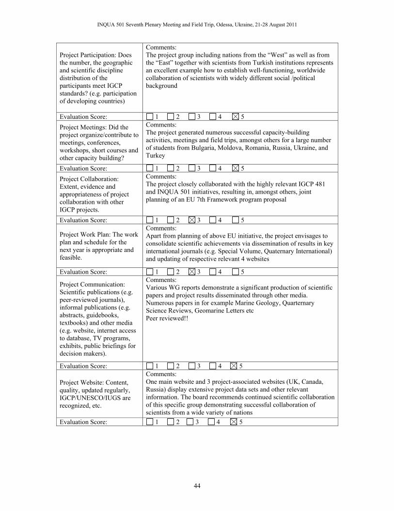
INQUA 501 Seventh Plenary Meeting and Field Trip, Odessa, Ukraine, 21-28 August 2011
44
Project Participation: Does the number, the geographic and scientific discipline distribution of the participants meet IGCP standards? (e.g. participation of developing countries)
Comments: The project group including nations from the “West” as well as from the “East” together with scientists from Turkish institutions represents an excellent example how to establish well-functioning, worldwide collaboration of scientists with widely different social /political background
Evaluation Score: 1 2 3 4 5 Project Meetings: Did the project organize/contribute to meetings, conferences, workshops, short courses and other capacity building?
Comments: The project generated numerous successful capacity-building activities, meetings and field trips, amongst others for a large number of students from Bulgaria, Moldova, Romania, Russia, Ukraine, and Turkey
Evaluation Score: 1 2 3 4 5 Project Collaboration: Extent, evidence and appropriateness of project collaboration with other IGCP projects.
Comments: The project closely collaborated with the highly relevant IGCP 481 and INQUA 501 initiatives, resulting in, amongst others, joint planning of an EU 7th Framework program proposal
Evaluation Score: 1 2 3 4 5
Project Work Plan: The work plan and schedule for the next year is appropriate and feasible.
Comments: Apart from planning of above EU initiative, the project envisages to consolidate scientific achievements via dissemination of results in key international journals (e.g. Special Volume, Quaternary International) and updating of respective relevant 4 websites
Evaluation Score: 1 2 3 4 5
Project Communication: Scientific publications (e.g. peer-reviewed journals), informal publications (e.g. abstracts, guidebooks, textbooks) and other media (e.g. website, internet access to database, TV programs, exhibits, public briefings for decision makers).
Comments: Various WG reports demonstrate a significant production of scientific papers and project results disseminated through other media. Numerous papers in for example Marine Geology, Quarternary Science Reviews, Geomarine Letters etc Peer reviewed!!
Evaluation Score: 1 2 3 4 5
Project Website: Content, quality, updated regularly, IGCP/UNESCO/IUGS are recognized, etc.
Comments: One main website and 3 project-associated websites (UK, Canada, Russia) display extensive project data sets and other relevant information. The board recommends continued scientific collaboration of this specific group demonstrating successful collaboration of scientists from a wide variety of nations
Evaluation Score: 1 2 3 4 5

INQUA 501 Seventh Plenary Meeting and Field Trip, Odessa, Ukraine, 21-28 August 2011
45
IGCP Funding: The requested funding for next year is appropriate and adequately justified.
Comments: No, project will be on O.E.T during 2010 which does not grant any funding.
Evaluation Score: 1 2 3 4 5
External Funds: The extent of external funding is appropriate and sufficient?
Comments: 2009, 26 000 USD have been given by several agencies for the project (see point 7).
Evaluation Score: 1 2 3 4 5 Project Response: The project leaders adequately took into account previous recommendations of the Scientific Board?
Comments: Yes
Evaluation Score: 1 2 3 4 5 RECOMMENDATIONS ON THE BASIS OF THE ABOVE ASSESSMENT: Overall Score: 1 2 3 4 5 Project should (select only one):
Continue as planned Continue with conditions (see below) Continue for one additional year only Continue on O.E.T. status (no funding) Be closed
Comments/Conditions: We recommend continued scientific collaboration of this specific group demonstrating successful collaboration of scientists from a wide variety of nations, addressing important scientific questions. OET, without funding (unfortunately as these are the rules). Project Review Theme Group: Theme Global Change-Life Date: 12.02.2010

INQUA 501 Seventh Plenary Meeting and Field Trip, Odessa, Ukraine, 21-28 August 2011
46
Year 2011

INQUA 501 Seventh Plenary Meeting and Field Trip, Odessa, Ukraine, 21-28 August 2011
47

INQUA 501 Seventh Plenary Meeting and Field Trip, Odessa, Ukraine, 21-28 August 2011
48