pc attachment 3
TRANSCRIPT

CHAPTER 9-34. - PLANNING AREA 34 (IRVINE SPECTRUM 5)[13]
Footnotes:
--- (13) ---
Note— Planning Area 34 is was originally covered by Vesting Tentative Parcel Map No. 87-TP-0356. Please see this Chapter 9-34, the zoning ordinance in effect at the time the application for the vesting tentative map was deemed complete, September 26, 1987, and the zoning ordinance in effect at the time the parcel map was approved, August 22, 1990.
Sec. 9-34-1. - Land use zoning map.
(See Planning Area 34 map following Section 9-34-3.)
(Code 1976, § V.E-834.1; Ord. No. 92-3, 4-14-92; Ord. No. 92-14, § 4, 9-8-92; Ord. No. 92-21,
11-24-92; Ord. No. 94-7, § 3, 6-14-94; Ord. No. 95-4, 5-9-95; Ord. No. 95-22, § 3, 11-28-95;
Ord. No. 12-09, § 3(Exh. B), 5-22-12 )
Sec. 9-34-2. - Introduction.
Planning Area 34, Irvine Spectrum 5, is located along the eastern edge of the City. Boundaries include Irvine Center Drive and the future extension of Bake Parkway to the west, Interstate 405 (San Diego Freeway) and Interstate 5 (Santa Ana Freeway) to the north, and Lake Forest Drive to the south.
(Code 1976, § V.E-834.2; Ord. No. 92-3, 4-14-92; Ord. No. 92-14, § 4, 9-8-92; Ord. No. 92-21,
11-24-92; Ord. No. 94-7, § 3, 6-14-94; Ord. No. 95-4, 5-9-95; Ord. No. 95-22, § 3, 11-28-95;
Ord. No. 99-03, § 3, 2-9-99)
PC ATTACHMENT 3

Sec. 9-34-3. - Statistical analysis.
Building Intensity Standard
General Plan
Category
Zoning
Number
Zoning
District
Maximum
Regulatory
Dwelling Units
Additive
Dwelling
Units 2
Maximum
Regulatory
Square Feet 3, 4
Additive
Square
Feet 2
Conservation
and Open
Space:
Preservation 1.4 Preservation 0 0 0 0
Commercial:
Community
Commercial 4.2D
Community
Commercial 0 0
963,930
906,930 0
Industrial:
Research and
Industrial 5.4
General
Industrial 0 0
4,763,300
4,820,300 0
Unallocated
Dwelling Units 1 n/a n/a 0 0 0 0
PLANNING AREA TOTAL 0 0 5,727,230
0
1 Unallocated dwelling units represent those units remaining in a planning area that may be built
anywhere in the same planning area. These units are within the maximum development intensity
for the planning area; and, therefore, placement of unallocated dwelling units into any residential
category within the planning area for purposes of development is determined to be consistent
with the General Plan and Zoning Code with regard to intensity allocation only, provided that
placement is otherwise consistent with site specific zoning regulations and that any potential
environmental impacts are adequately addressed, including traffic impacts, pursuant to CEQA.
2 See Section 9-0-3.C, Building Intensity Standards.

3 In Planning Area 34 within the 5.4A General Industrial zone, the developer has the option to
construct up to 63,681 square feet of R&D or in lieu of that, up to 126,000 square feet of mini-
warehouse. A limited scope traffic study will be prepared as part of the building permit
application for development of mini-warehouse in excess of 63,681 square feet and up to
126,000 square feet of mini-warehouse. If this option is exercised, the city shall administratively
increase the General Plan and Zoning caps for Planning Area 34 by the square footage to
accommodate it.
(Code 1976, § V.E-834.3; Ord. No. 92-3, 4-14-92; Ord. No. 92-14, § 4, 9-8-92; Ord. No. 92-21,
11-24-92; Ord. No. 94-7, § 3, 6-14-94; Ord. No. 95-4, 5-9-95; Ord. No. 95-22, § 3, 11-28-95;
Ord. No. 06-05, § 6, 6-27-06; Ord. No. 12-09, § 3(Exh. A), 5-22-12 )
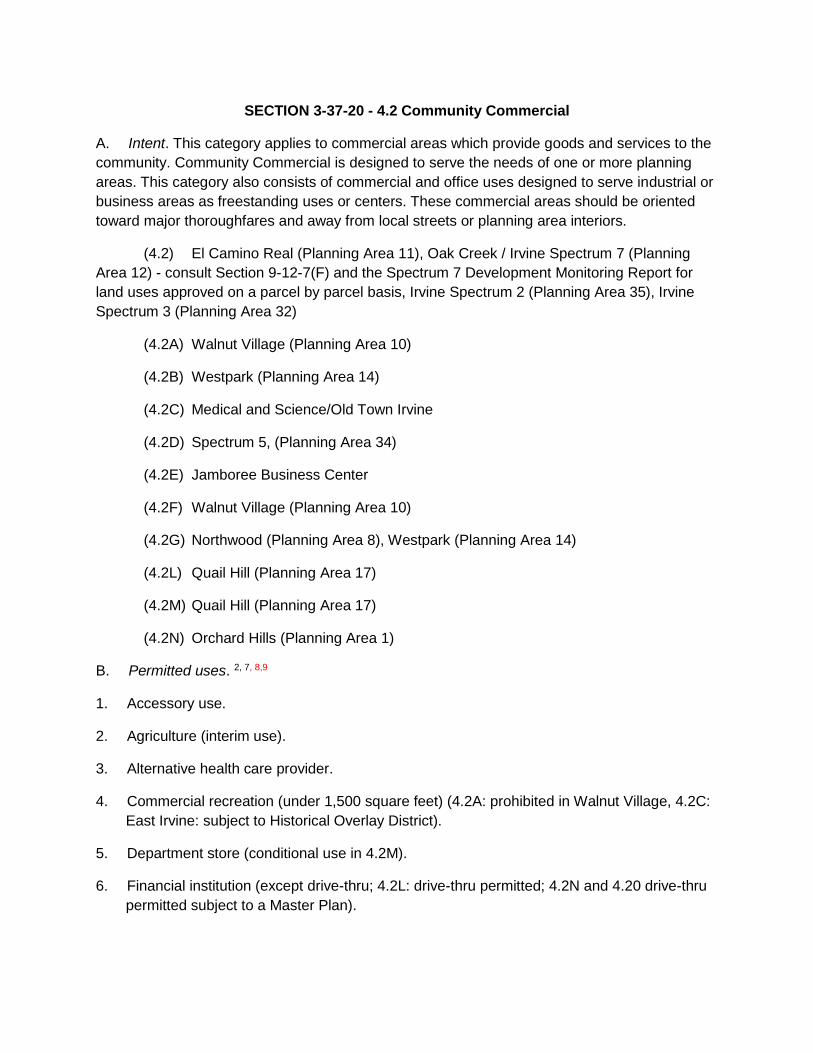
SECTION 3-37-20 - 4.2 Community Commercial
A. Intent. This category applies to commercial areas which provide goods and services to the
community. Community Commercial is designed to serve the needs of one or more planning
areas. This category also consists of commercial and office uses designed to serve industrial or
business areas as freestanding uses or centers. These commercial areas should be oriented
toward major thoroughfares and away from local streets or planning area interiors.
(4.2) El Camino Real (Planning Area 11), Oak Creek / Irvine Spectrum 7 (Planning
Area 12) - consult Section 9-12-7(F) and the Spectrum 7 Development Monitoring Report for
land uses approved on a parcel by parcel basis, Irvine Spectrum 2 (Planning Area 35), Irvine
Spectrum 3 (Planning Area 32)
(4.2A) Walnut Village (Planning Area 10)
(4.2B) Westpark (Planning Area 14)
(4.2C) Medical and Science/Old Town Irvine
(4.2D) Spectrum 5, (Planning Area 34)
(4.2E) Jamboree Business Center
(4.2F) Walnut Village (Planning Area 10)
(4.2G) Northwood (Planning Area 8), Westpark (Planning Area 14)
(4.2L) Quail Hill (Planning Area 17)
(4.2M) Quail Hill (Planning Area 17)
(4.2N) Orchard Hills (Planning Area 1)
B. Permitted uses. 2, 7, 8,9
1. Accessory use.
2. Agriculture (interim use).
3. Alternative health care provider.
4. Commercial recreation (under 1,500 square feet) (4.2A: prohibited in Walnut Village, 4.2C:
East Irvine: subject to Historical Overlay District).
5. Department store (conditional use in 4.2M).
6. Financial institution (except drive-thru; 4.2L: drive-thru permitted; 4.2N and 4.20 drive-thru
permitted subject to a Master Plan).

7. Gas station/fuel dispenser (only in 4.2L; only in 4.2N subject to a Master Plan; otherwise
conditional/prohibited).
8. Health club (only in 4.2N and 4.20 subject to a Master Plan; otherwise conditional/
prohibited).
9. Industry, service (4.2B and 4.2M: conditional uses; 4.20: prohibited use).
10. Information center.
11. Manufactured structure permit (up to 2 years).
12. Manufacturing, Light (4.2E: Jamboree Business Center only; see special development
requirements).
13. Office, administrative, business professional.
14. Office, design professionals.
15. Office, headquarters.
16. Office, medical.
17. Outdoor vendor.
18. Park.
19. Parking structures and parking facilities (only in 4.2L, M, N and O).
20. Public park facility (only in public parks).
21. Pushcart.
22. Research and development (permitted only in Planning Areas 12, 17, 32, 34, 35).
23. Restaurant.
24. Restaurant, fast-food (except drive-thru; 4.2L: drive-thru permitted; 4.2N and 4.20: drive-
thru permitted subject to a Master Plan).
25. Retail and/or service business, general (except drive-thru).
26. Retail business, home improvement related.
27. Reverse vending machine.
28. School, commercial.
29. School, public.
30. Supermarket.

31. Veterinary service, domestic.
32. Warehouse and sales outlet (4.2M: conditional use in PA 17).
33. Warehouse, storage and distribution (4.2 E Jamboree Business Center only; see special
development requirements).
34. Wireless communication facility (may require a wireless communication facility permit, a
minor conditional use permit, a major conditional use permit or may be prohibited,
depending on the type of installation and the location of the installation site, pursuant to
the review procedures matrix in Section 2-37.5-3).
C. Conditional uses. 4, 7, 8,9
1 Permitted and conditional uses within Planning Area 4 (Lower Peters Canyon) are outlined in Section 9-
4-4, as provided in the Lower Peters Canyon Development Agreement.
2 Some permitted uses may have to conform to or fulfill conditions of approval imposed in conjunction with
previous discretionary approvals. Additionally, a Master Plan application may need to be processed (see
Chapter 2-17).
3 Reserved.
4 A Master Plan application may be required in addition to a conditional use permit (see Chapter 2-17).
5 A church that proposes to locate in an existing permanent building and meets all the general
development standards will not require a conditional use permit (CUP).
6 Domestic animal care facilities shall require a veterinary certificate of health and proof of current
vaccinations for distemper, rabies and parvovirus. Animals may be groomed, trained, exercised socialized
and kept or boarded overnight, but not bred, sold or let for hire.
7 In Planning Area 12, even though a land use may be listed as permitted or conditionally permitted, the
use may be limited or prohibited on certain properties, based on how the property was analyzed in the
Spectrum 7 Traffic Study, dated July 31, 2020 (refer to Section 9-12-7(F).
8 In Planning Area 34, permitted and conditionally permitted land uses shall be categorized by Staff into
one of the five trip rate categories (commercial, office, research/development, health club, or government
facility) identified in the traffic study approved as part of the 2006 EIR for GPA/ZC for Planning Areas 18,
33, 34 and 39. If a conditional use permit is required, additional traffic analyses may be required.
9 Permitted and conditionally permitted land uses within Planning Area 34 (Irvine Spectrum 5) are outlined
in Section 9-34-4.

SECTION 3-37-33 - 5.4 General Industrial
A. Intent. This category reserves an area for uses such as manufacturing, warehousing and
service industries.
(5.4) Irvine Spectrum 2 (Planning Area 35)
Irvine Spectrum 8 (Planning Area 40)
Oak Creek (Planning Area 12)
(5.4A) Irvine Spectrum 5 (Planning Area 34)
(5.4B) Oak Creek (Planning Area 12) – consult Section 9-12-7(F) and the Spectrum 7
Development Monitoring Report for land uses approved on a parcel by parcel
basis
Irvine Spectrum 3 (Planning Area 32)
Orange County Great Park (Planning Area 30)
B. Permitted uses. 1, 9, 10,11
1. Accessory use.
2. Agriculture (interim use).
3. Alternative health care provider (permitted only in 5.4B).
4. Cannabis testing laboratory (not allowed within 600 feet of schools or residences).
5. Caretaker's quarters.
6. Domestic animal care facility. 8
7. Emergency shelter.
8. Industry, service.
9. Manufactured structure permit (up to two years).
10. Manufacturing, light. 2
11. Miniwarehouse.
12. Office, administrative, business, professional (permitted only in 5.4B) 2

13. Office, design professionals (permitted only in Planning Areas 12, 13, 32, 34, 35). 2
14. Office, headquarters. (permitted only in 5.4B) 2
15. Outdoor vendor.
16. Packing plant for agricultural products.
17. Park.
18. Public park facilities (only in public parks).
19. Pushcart.
20. Research and development. 2
21. Restaurant, fast food (except drive-thru). 7
22. Reverse vending machine.
23. Sexually oriented business.
24. Warehouse and sales outlet. 7
25. Warehousing, storage and distribution. 2
26. Wireless communication facility (may require a wireless communication facility permit, a
minor conditional use permit, a major conditional use permit or may be prohibited,
depending on the type of installation and the location of the installation site, pursuant to
the review procedures matrix in Section 2-37.5-3).
C. Conditional uses. 3, 9, 10,11
1 Some permitted uses may have to conform to or fulfill conditions of approval imposed in conjunction with
previous discretionary approvals. Additionally, a Master Plan application may need to be processed
(Consult Chapter 2-17).
2 Incidental offices in conjunction with permitted or conditionally permitted uses may occupy up to 50
percent of a parcel or site in 5.4 and 5.4A. In 5.4B, 100 percent office is generally allowed. However, in
Planning Area 12, specific permitted or conditionally permitted land uses in 5.4B may be limited to 50
percent incidental office, based on how the site was analyzed in the Spectrum 7 Traffic Study, dated July
31, 2020 (refer to Section 9-12-7(F).
3 A Master Plan application may be required in addition to a conditional use permit (Consult Chapter 2-
17).
4 A church that proposes to locate in an existing permanent building and meets all the general
development standards will not require a conditional use permit (CUP). However, churches with
permanent child care or private school activities shall be subject to a conditional use permit.

5 A commercial or private school for adults (18 years and older) that proposes to locate in an existing
permanent building and meets all the general development standards, including trip limitations, will not
require a conditional use permit.
6 Exceptions to these building setback requirements appear on the setback exceptions matrix in Section
3-27-2.
7 This land use is an exception to the use of a single trip rate for permitted uses within the 5.4B General
Industrial Zone in Irvine Spectrum 3 (Planning Area 32). Refer to Section 9-32-7-A.1.d, calculation of site
trips.
8 Domestic animal care facilities shall require a veterinary certificate of health and proof of current
vaccinations for distemper, rabies and parvovirus. Animals may be groomed, trained, exercised socialized
and kept or boarded overnight, but not bred, sold or let for hire. Prohibited in Planning Area 30.
9 In Planning Area 12, even though a land use may be listed as “permitted” or “conditionally permitted,”
the use may be limited or prohibited on certain properties, based upon how the property was analyzed in
the Spectrum 7 Traffic Study, dated July 31, 2020 (referred to in Section 9-12-7(F).
10 In Planning Area 34, permitted and conditionally permitted land uses shall be categorized by Staff into
one of the five trip rate categories (commercial, office, research/development, health club, or government
facility) identified in the traffic study approved as part of the 2006 EIR for GPA/ZC for Planning Areas 18,
33, 34 and 39. If a conditional use permit is required, additional traffic analyses may be required.
11 Permitted and conditionally permitted land uses within Planning Area 34 (Irvine Spectrum 5) are
outlined in Section 9-34-4.

RESIDENTIAL MULTI-USE(2) (15) INSTITUTIONAL(3)COMMERCIAL ADDITIVE Maximum Maximum
Planning Estate Low Med Med-High High High Unallocated 0-40 Square Public Educational Research/ Community Neighborhood Regional(5)Regional Commercial Maximum Maximum D.U. Sq. Ft. With With
Area 0-1 0-5 0-10 0-25 0-40 Residential D.U. Feet 0-40 Facility Facility 30 D.U./ Square Industrial Commercial Commercial Commercial Commer- Recreation D.U.(6)(11)Square Additive Additive
Number D.U. D.U. D.U. D.U. D.U. D.U. (25)D.U. Sq. Ft. Sq. Ft. acre min. Feet Sq. Ft. Sq. Ft. Sq. Ft. Sq. Ft. cial D.U. Sq. Ft. Feet Units Sq. Ft.
1 0 4,088 0 0 0 0 0 0 0 0 0 0 0 0 132,500 0 0 0 0 4,088 132,500 0 0 4,088 132,500
3(1)0 0 0 0 0 0 0 0 0 0 0 0 0 0 0 0 0 0 0 0 0 0 0 0 0
4(11)(12)0 0 5,361 2,315 0 293 0 0 0 4,380 490,050 0 0 1,423,000 124,410 0 865,590 0 0 7,969 2,907,430 162 0 8,131 2,907,430
5 0 758 2,442 630 0 0 0 0 0 0 0 0 0 0 0 0 0 0 0 3,830 0 0 0 3,830 0
6(28)0 0 4,670 0 0 0 790 625,000 0 0 0 0 0 0 175,000 0 0 0 0 5,460 800,000 0 0 5,460 800,000
8 0 1,188 4,521 1,978 425 68 0 171,591 0 0 188,174 0 0 0 829,400 285,200 0 121 0 8,301 1,474,365 0 0 8,301 1,474,365
9 0 0 4,222 4,610 0 0 0 450,000 0 0 0 0 0 0 0 0 0 0 0 8,832 450,000 0 0 8,832 450,000
10 0 0 2,305 248 0 140 190 0 0 0 39,950 0 0 2,822,921 813,608 73,661 0 0 0 2,883 3,750,140 0 0 2,883 3,750,140
11 0 0 2,818 2,590 0 12 0 71,174 0 99,623 367,580 0 0 0 511,205 56,645 0 0 0 5,420 1,106,227 0 0 5,420 1,106,227
12(7)0 0 190 2,164 1,172 40 694 470,000 0 194,440 150,000 0 0 3,603,281 955,000 150,000 0 0 0 4,260 5,522,721 0 0 4,260 5,522,721
13 0 0 0 0 0 0 0 0 0 1,585,263 0 0 0 3,558,010 0 0 0 0 0 0 5,143,273 0 1,355,359 0 6,498,632
14 0 758 1,064 3,410 0 53 0 0 0 227,322 91,313 0 0 0 618,801 179,906 0 0 0 5,285 1,117,342 0 0 5,285 1,117,342
15(15)0 0 8,442 452 477 0 140 440,158 0 321,079 359,270 0 0 0 715,736 221,053 0 0 0 9,511 2,057,296 120 56,465 9,631 2,113,761
16 0 0 0 0 0 0 0 0 0 0 0 0 0 0 0 0 0 0 0 0 0 0 0 0 0
17(8)0 0 2,546 0 0 0 0 0 0 0 0 0 0 1,060,000 150,000 0 0 0 0 2,546 1,210,000 120 0 2,666 1,210,000
18(8)0 258 597 0 0 0 0 0 0 0 0 0 0 0 0 0 0 0 0 855 0 0 0 855 0
19 0 0 0 1,735 0 49 0 0 0 9,374 0 0 0 0 0 38,410 0 0 255,980 1,784 303,764 0 0 1,784 303,764
20 0 354 1,677 781 0 0 0 0 0 36,936 116,207 0 0 0 0 173,542 0 0 0 2,812 326,685 0 0 2,812 326,685
21 0 3,124 77 722 0 0 0 0 330 30,000 538,921 0 0 0 0 0 0 0 0 4,253 568,921 0 0 4,253 568,921
22(8)400 0 0 0 0 0 0 0 0 0 0 0 0 0 0 0 0 0 0 400 0 0 0 400 0
23 0 0 0 0 1,000 0 0 0 40 112,230 0 0 0 0 0 0 0 0 0 1,040 112,230 0 0 1,040 112,230
24 0 0 0 2,757 0 0 0 654,000 0 25,850 0 0 0 0 0 68,953 0 0 0 2,757 748,803 0 0 2,757 748,803
25 0 0 0 0 0 0 0 0 0 0 0 0 0 1,436,170 0 0 0 0 0 0 1,436,170 0 50,000 0 1,486,170
27(8)0 0 772 882 0 403 0 0 0 210,740 0 0 0 0 0 0 0 0 0 2,057 210,740 0 0 2,057 210,740
28 0 0 0 0 0 0 0 0 0 0 0 0 0 0 0 0 0 0 0 0 0 0 0 0 0
29 0 0 0 0 0 0 0 0 435 0 761,000 0 0 0 0 0 0 0 0 435 761,000 0 0 435 761,000
31 0 0 0 0 0 0 0 0 0 350,370 0 0 0 6,888,383 147,359 0 0 0 0 0 7,386,112 0 0 0 7,386,112
32 0 0 0 0 0 0 0 0 0 0 0 0 0 4,355,127 1,398,947 0 0 0 0 0 5,754,074 0 0 0 5,754,074
33(19)0 0 0 0 0 0 0 0 0 0 0 0 0 0 0 0 7,955,092 4,356 0 4,356 7,955,092 0 0 4,356 7,955,092
34 0 0 0 0 0 0 0 0 0 0 0 0 0 4,763,300 963,930 0 0 0 0 0 5,727,230 0 0 0 5,727,230
35 0 0 0 0 0 0 0 0 0 62,101 0 0 0 13,792,072 1,252,654 0 0 0 0 0 15,106,827 0 0 0 15,106,827
36(21)(22)(23)(29)0 0 0 0 0 4,125 0 0 0 0 0 10,875 48,787,662 0 0 0 0 0 0 15,000 48,787,662 2,038 0 17,038 48,787,662
38 0 0 1,213 2,001 0 199 0 0 0 0 0 0 0 0 0 0 0 0 0 3,413 0 0 0 3,413 0
39 0 0 0 3,700 0 0 0 0 0 0 0 0 0 0 0 0 0 0 0 3,700 0 0 0 3,700 0
40 0 0 1,595 2,323 0 0 0 1,540,000 0 0 100,000 0 0 1,662,352 205,000 0 0 0 0 3,918 3,507,352 0 0 3,918 3,507,352
50(10)0 0 0 0 0 0 0 0 9,500 0 9,810,293 0 0 0 0 0 0 0 0 9,500 9,810,293 0 0 9,500 9,810,293
51(16)(17)(18)(26)(27)0 0 0 0 0 0 7,037 1,318,200 0 1,233,000 0 0 0 3,364,000 220,000 0 0 0 0 7,037 6,135,200 2,463 0 9,500 6,135,200
Unallocated 0 0 0 0 0 0 0 0 0 0 0 0 0 0 0 60,000 0 0 0 0 0 0 0 0 0
TOTAL 400 10,528 44,512 33,298 3,074 5,382 8,851 5,740,123 10,305 4,502,708 13,012,758 10,875 48,787,662 48,728,616 9,213,550 1,307,370 8,820,682 4,477 255,980 131,702 140,309,449 4,912 1,461,824 136,613 141,771,273
TABLE A-1 MAXIMUM INTENSITY STANDARDS BY PLANNING AREA- DETACHED LANDS
RESIDENTIAL MULTI-USE(2) INSTITUTIONAL(3) INDUSTRIAL COMMERCIAL MILITARY Maximum Maximum
Planning Estate Low Medium Med-High High High Unallocated 0-40 Square Public Educational Urban/Industrial(4)Research/ Community Neighborhood Regional(5)
Regional Commercial Maximum Maximum 0-10 Sq. With With
Area 0-1 0-5 0-10 0-25 0-40 Residential D.U. Feet 0-40 Facility Facility 0-40 Square Industrial Commercial Commercial Commercial Commer- Recreation Dwelling Square D.U. Ft Additive Additive
Number D.U. D.U. D.U. D.U. D.U. D.U. (25)D.U. Sq. Ft. Sq. Ft. D.U. Feet Sq. Ft. Sq. Ft. Sq. Ft. Sq. Ft. cial D.U. Sq. Ft. D.U.(6)(11) Feet Units Sq. Ft.
26(8)0 0 420 1,580 0 0 0 800 405,100 0 0 46,487 0 0 0 110,000 0 0 0 0 2,800 561,587 0 0 2,800 561,587
27 0
TOTAL 0 0 420 1,580 0 0 0 800 405,100 0 0 46,487 0 0 0 110,000 0 0 0 0 2,800 561,587 0 0 2,800 561,587
TABLE A-1 MAXIMUM INTENSITY STANDARDS BY PLANNING AREA
INDUSTRIAL
Urban/Industrial(4)(21)
City of Irvine General Plan Land Use Element, Supplement 9, July 2015
906,9304,820,300
City of Irvine A-23 Land Use Element General Plan Supplement 9, July 2015
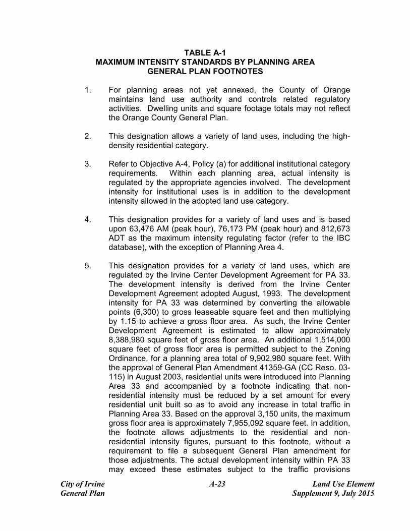
TABLE A-1 MAXIMUM INTENSITY STANDARDS BY PLANNING AREA
GENERAL PLAN FOOTNOTES
1. For planning areas not yet annexed, the County of Orange maintains land use authority and controls related regulatory activities. Dwelling units and square footage totals may not reflect the Orange County General Plan.
2. This designation allows a variety of land uses, including the high-
density residential category.
3. Refer to Objective A-4, Policy (a) for additional institutional category requirements. Within each planning area, actual intensity is regulated by the appropriate agencies involved. The development intensity for institutional uses is in addition to the development intensity allowed in the adopted land use category.
4. This designation provides for a variety of land uses and is based
upon 63,476 AM (peak hour), 76,173 PM (peak hour) and 812,673 ADT as the maximum intensity regulating factor (refer to the IBC database), with the exception of Planning Area 4.
5. This designation provides for a variety of land uses, which are
regulated by the Irvine Center Development Agreement for PA 33. The development intensity is derived from the Irvine Center Development Agreement adopted August, 1993. The development intensity for PA 33 was determined by converting the allowable points (6,300) to gross leaseable square feet and then multiplying by 1.15 to achieve a gross floor area. As such, the Irvine Center Development Agreement is estimated to allow approximately 8,388,980 square feet of gross floor area. An additional 1,514,000 square feet of gross floor area is permitted subject to the Zoning Ordinance, for a planning area total of 9,902,980 square feet. With the approval of General Plan Amendment 41359-GA (CC Reso. 03-115) in August 2003, residential units were introduced into Planning Area 33 and accompanied by a footnote indicating that non-residential intensity must be reduced by a set amount for every residential unit built so as to avoid any increase in total traffic in Planning Area 33. Based on the approval 3,150 units, the maximum gross floor area is approximately 7,955,092 square feet. In addition, the footnote allows adjustments to the residential and non-residential intensity figures, pursuant to this footnote, without a requirement to file a subsequent General Plan amendment for those adjustments. The actual development intensity within PA 33 may exceed these estimates subject to the traffic provisions

City of Irvine A-24 Land Use Element General Plan Supplement 9, July 2015
contained in the Development Agreement. Within Planning Area 4, this designation provides for a variety of land uses as provided by the Lower Peters Canyon Development Agreement.
6. The permitted range of dwelling units (low-high) may be less than
that allowed by the available acreage. The residential intensity ranges are based on estimated gross figures and may be adjusted through technical refinements to reflect more accurate information at subsequent planning levels.
7. Within Planning Area 12, the multi-use designation allows medium
high or high density residential use.
8. On September 26, 1988, the "Memorandum of Understanding Implementing Initiative Resolution 88-1" was approved, establishing a 10,600 dwelling unit cap for Planning Areas 17, 18, 22, 26 and 27. In addition, the Memorandum permits up to 800 dwelling units in lieu of commercial in Planning Area 26, for an overall cap of up to 11,400 dwelling units.
9. Reserved.
10. The University of California controls land use authority and related
regulatory activities. Dwelling unit totals are based on the University's Long-Range Development Plan.
11. Total residential Dwelling Units within Planning Area 4 shall not
exceed 7,969.
12. Residential uses within Sector 11 of Planning Area 4 shall not exceed 2,830 ADT unless additional environmental documentation ensures traffic mitigation.
13. Reserved.
14. Derived from Planning Area 22 Zone Change [16868-ZC, CC Reso
95-79)].
15. In Planning Area 15, a total of 50,526 square feet of Institutional Uses are located on a site have been allocated equally to two sites designated as High Density Residential and located at 4445 Alton Parkway and 23 Lake Street designated as High Density Residential. Additionally, 5,939 square feet of Institutional Uses have been allocated to a site designated as Multi-Use and located at 5010 Barranca Parkway. This square footage is considered

City of Irvine A-25 Land Use Element General Plan Supplement 9, July 2015
additive and is not included in the Planning Area 15 total intensity caps.
16. Maximum Square Footages for Multi-Use Non-Residential Conversions: The “Heritage Fields Project 2012
General Plan Amendment and Zone Change Traffic Analysis, approved November 26, 2013, or subsequent traffic analysis amending those assumptions, analyzed 1,318,200 square feet of Multi-Use (Office) in Planning Area 51. If any other non-residential land uses within 8.1 TTOD zoning district are proposed in-lieu of Multi-Use (Office), the square footage may be adjusted accordingly within the General Plan Table A-1 without the need for a General Plan Amendment.
17. The 1,233,000 square feet in Institutional/Public Facilities in
Planning Area 51 includes 122,500 square feet for Orange County Transit Authority facilities; 300,000 square feet for County of Orange facilities; 263,000 square feet for warehousing for homeless providers; 468,000 square feet of institutional uses; 26,000 square feet of sports park; and 53,500 square feet of remote airport terminal.
18. In order to develop at the maximum intensities for Planning Area51,
the property owner has entered into a development agreement, (recorded on July 12, 2005), which requires the dedication of land and the development or funding of infrastructure improvements in excess of the City’s standard requirements, and the commitment to long-term maintenance of public facilities. This agreement was amended by the Amended and Restated Development Agreement adopted pursuant to City Council Ordinance 09-09.
19. To the extent that residential units are built in PA 33, within the
4.7C Urban Commercial District, a corresponding reduction in the allowable non-residential intensity shall occur in terms of equivalent traffic generated. The actual amount of reduction in non-residential intensity will be based upon a conversion rate of 648 square feet of non-residential intensity per dwelling unit (as established in the traffic analysis “City of Irvine Spectrum 1 Traffic Analysis” July 2003). Revisions to the non-residential and residential intensity figures for PA 33 (consistent with this note) are authorized without the need for a subsequent general plan amendment
20. Reserved
21. Reserved

City of Irvine A-26 Land Use Element General Plan Supplement 9, July 2015
22. Reserved 23. Development Agreement 00310468-PDA vested certain
entitlements for the Park Place development (collectively, the “Vested Park Place Entitlements”). The Vested Park Place Entitlements include the right to allocate the maximum permitted intensity of development within Park Place among the various permitted and conditionally permitted uses utilizing the development points system set forth in Section V.E.-736.5 of the 1989 Zoning Code (the “1989 Point System”). The maximum intensity limits for Planning Area 36 allow for up to 3,450 dwelling units within Park Place subject to an overall intensity limit 8,567,880 total points under the 1989 Point System which have been allocated to Park Place under the Vested Park Place Entitlements. To the extent that the 3,450 maximum unit entitlement is not developed at Park Place, non-residential uses may be developed at Park Place by utilizing unused points under the 1989 Point System. Total construction within Park Place shall not exceed any of the following intensity limits: 3,450 residential dwelling units and 8,567,880 points under the 1989 Point System.
24. Reserved
25. Unallocated dwelling units represent those units remaining in a
Planning Area that may be built anywhere in the same Planning Area. These units are within the maximum development intensity for the Planning Area; and, therefore placement of unallocated units into any residential category within the planning area for purposes of development is determined to be consistent with the General Plan and Zoning Code with regard to intensity allocation only, provided that placement is otherwise consistent with site specific zoning regulations and that any potential environmental impacts are adequately addressed, including traffic impacts, pursuant to CEQA. Additionally, unallocated units in Planning Area 4 cannot be transferred between sectors per an existing development agreement.
26. On July 12, 2005, the City and Heritage Fields LLC executed the
Great Park Development Agreement that vested Heritage Fields’ right to develop 3,625 base units in Planning Areas 30 and 51(now referred to as Planning Area 51 with the 2012 General Plan Amendment and Zone Change). The November 6, 2008 Planning Commission approval of the Master Affordable Housing Plan and the Density Bonus Application granted the right to develop 1,269 density bonus units in Planning Areas 30 and 51 (now referred to

City of Irvine A-27 Land Use Element General Plan Supplement 9, July 2015
as Planning Area 51 with the 2012 General Plan Amendment and Zone Change). The City Council later approved the Density Bonus Agreement on August 9, 2009 regarding the implementation of the 1,269 density bonus units. The 2012 General Plan Amendment and Zone Change increase the maximum number of base units to 7,037 (3,625 plus 3,412) and the maximum number of density bonus units to 2,463 (1,269 plus 1,194) for a maximum of 9,500 units.
27. Density Bonus units granted pursuant to state law.
28. The development intensity allocated to 8.1A equates to 175,000
square feet of office use and 325,000 square feet of Research and Development use with a post-2030 trip limit of 5,115 average daily trips, 506 am peak hour trips and 509 pm peak hour trips based on NITM land use rates. To the degree residential units, up to a maximum of 790 dwelling units, or other uses are built in 8.1A, a corresponding reduction in the allowable Office and/or Research and Development intensity shall occur in terms of equivalent traffic generation based on a.m. peak, p.m. peak, and average daily trips. The actual amount of reduction will be based on land use based traffic generation rates, and using an average trip generation rate (10.73 ADT, 0.98 am peak hour trips and 0.94 pm peak hour trips per 1,000 square feet of office use and 9.96 ADT, 1.03 am peak hour trips and 1.06 pm peak hour trips per 1,000 square feet of research and development use) for Office and/or Research and Development intensity and the applicable rates for any proposed non-office use, as determined by the Director of Community Development.
29. The IBC Vision Plan, adopted by City Council in July 2010,
assumed a theoretical total of 2,038 density bonus units. This total is based on 655 total density bonus units existing, under construction, approved, or in process at the time of Vision Plan adoption, plus an additional 1,383 potential density bonus units based on the maximum allowed pursuant to state law for the 3,950 potential base units identified to reach the 15,000 base unit cap at the time of Vision Plan approval. The minimum required density is 30 units per acre.
The Maximum Allowable Square Footage within Planning Area 36 can adjust upward or downward based upon the mix of land uses and is not considered a development cap as is the case in other planning areas. This estimated number can be adjusted as needed by City Staff as long as the resulting Planning Area development intensity is within the Planning Area Development Intensity Value budget. Land uses may be changed to any permitted or

City of Irvine A-28 Land Use Element General Plan Supplement 9, July 2015
conditionally permitted use within the corresponding zoning district, with the established development intensity values.
Unallocated dwelling units represent those units remaining in a Planning Area that may be built anywhere in the same Planning Area. These units are within the maximum development intensity for the Planning Area; and, therefore placement of Unallocated dwelling units into any residential category within the planning area for purposes of development is determined to be consistent with the General Plan and Zoning Code with regard to intensity allocation only, provided that placement is otherwise consistent with site specific zoning regulations and that any potential environmental impacts are adequately addressed, including traffic impacts, pursuant to CEQA.
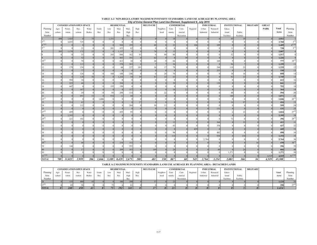
TABLE A-2 NON-REGULATORY MAXIMUM INTENSITY STANDARDS: LAND USE ACREAGE BY PLANNING AREA
CONSERVATION/OPEN SPACE RESIDENTIAL MULTI-USE COMMERCIAL INDUSTRIAL INSTITUTIONAL MILITARY GREAT
Planning Agri- Preser- Rec- Water Estate Low Med. Med.- High Neighbor- Com- Com- Regional Urban Research/ Educa- PARK Total Planning
Area culture vation reation Bodies Res. Res. Res. High Res. hood munity mercial Industrial Industrial tional Public Acres Area
Number Res. Recreation Facilities Facilities Number
1 498 1,925 0 75 1,331 0 0 0 0 0 18 0 0 0 0 45 19 0 0 3,911 1
3(2)0 3,035 725 0 0 0 0 0 0 0 0 0 0 0 0 0 0 0 0 0 3,760 3(2)
4(1)(6)
0 0 8 0 0 0 920 195 0 48 0 23 0 106 0 109 0 0 0 0 1,409 4(1)(6)
5(1)
0 0 21 0 0 201 433 62 0 0 0 0 0 0 0 0 11 0 0 0 728 5(1)
6 205 1,178 172 22 0 0 1,137 0 0 78 0 15 0 0 0 0 0 0 0 0 2,807 6
8 6 0 33 0 0 245 846 162 41 6 40 86 0 0 0 0 52 0 0 0 1,517 8
9 0 0 52 0 0 0 883 191 0 62 0 0 38 0 0 0 0 0 0 0 1,226 9
10(1)
0 0 70 0 0 0 413 18 0 24 9 66 0 0 0 168 9 0 0 0 777 10(1)
11 0 0 113 0 0 0 570 303 0 7 7 56 0 0 0 0 96 7 0 0 1,159 11
12 0 179 154 0 0 0 60 227 101 36 17 78 0 0 0 244 110 23 0 0 1,229 12
13 0 0 77 0 0 0 0 0 0 0 0 0 0 0 0 253 0 0 0 0 330 13
14 0 0 126 0 0 168 188 246 0 0 20 76 0 0 0 0 18 16 0 0 858 14
15 0 0 128 56 0 0 1,228 54 39 41 22 63 0 0 0 0 92 22 0 0 1,745 15
16 0 594 18 0 0 0 0 0 0 0 0 0 0 0 0 0 0 0 0 0 612 16
17 0 225 44 0 0 0 394 0 0 0 0 39 0 0 0 139 0 0 0 0 841 17
18 0 447 0 0 0 155 150 0 0 0 0 0 0 0 0 0 0 0 0 0 752 18
19 0 0 167 0 0 0 0 157 0 0 0 18 22 0 0 0 0 0 0 0 364 19
20 0 0 19 0 0 93 298 114 0 0 22 0 0 0 0 0 48 0 0 0 594 20
21 0 0 691 53 0 916 11 60 0 0 0 0 0 0 0 0 140 0 0 0 1,871 21
22(3)
0 0 0 0 1,046 0 0 0 0 0 0 0 0 0 0 0 0 0 0 0 1,046 22(3)
23 0 214 62 0 0 0 0 0 27 0 0 0 0 0 0 0 16 97 0 0 416 23
24 0 0 112 0 0 0 0 204 0 30 13 0 0 0 0 0 0 0 0 0 359 24
25 0 0 0 0 0 0 0 0 0 0 0 0 0 0 0 131 0 0 0 0 131 25
27(4)0 459 0 0 0 0 455 95 0 0 0 0 0 0 0 0 2 13 0 0 1,024 27(4)
28 0 2,395 0 0 0 0 0 0 0 0 0 0 0 0 0 0 0 0 0 0 2,395 28
29(5)0 221 102 0 0 0 0 0 0 0 0 0 0 0 0 0 73 0 0 0 396 29(5)
31 0 0 0 0 0 0 0 0 0 0 0 12 0 0 0 364 0 35 0 0 411 31
32 0 0 0 0 0 0 0 0 0 0 0 83 0 0 0 354 0 0 0 0 437 32
33 0 6 0 0 0 0 0 0 0 0 0 0 0 439 0 0 0 0 0 0 445 33
34 0 0 0 0 0 0 0 0 0 0 0 96 0 0 0 402 0 0 0 0 498 34
35 0 0 0 0 0 0 0 0 0 0 0 114 0 0 0 930 0 110 0 0 1,154 35
36 0 0 0 0 0 0 0 0 0 0 0 0 0 0 2,764 0 0 0 0 0 2,764 36
38(1)0 0 48 0 0 0 234 152 0 0 0 0 0 0 0 0 0 0 36 0 470 38(1)
39 0 144 0 0 0 0 0 252 0 0 0 0 0 0 0 0 0 0 0 0 396 39
40 0 0 17 0 0 0 209 183 0 149 0 24 0 0 0 60 0 24 0 0 666 4050 0 0 0 0 0 0 0 0 0 0 0 0 0 0 0 0 1,371 0 0 0 1,371 50
51(7)(8)0 0 0 0 0 0 0 0 0 0 0 0 0 0 0 0 0 0 0 4,519 4,519 51(7)(8)
TOTAL 709 11,022 2,959 206 1,046 3,109 8,429 2,675 208 481 150 867 60 545 2,764 3,154 2,083 366 36 4,519 45,388
TABLE A-2 MAXIMUM INTENSITY STANDARDS: LAND USE ACREAGE BY PLANNING AREA - DETACHED LANDS
CONSERVATION/OPEN SPACE RESIDENTIAL MULTI-USE COMMERCIAL INDUSTRIAL INSTITUTIONAL MILITARY
Planning Agri- Preser- Rec- Water Estate Low Med. Med.- High Neighbor- Com- Com- Regional Urban Research/ Educa- Total Planning
Area culture vation reation Bodies Res. Res. Res. High Res. hood munity mercial Industrial Industrial tional Public Acres Area
Number Res. Recreation Facilities Facilities Number
26 0 155 400 43 0 0 186 280 0 37 0 23 0 0 0 0 0 0 0 1,124 26
27(4)0 85 58 0 0 75 6 61 0 0 0 0 0 0 0 0 0 5 0 290 27(4)
TOTAL 0 240 458 43 0 75 192 341 0 37 0 23 0 0 0 0 0 5 0 1,414
City of Irvine General Plan Land Use Element, Supplement 9, July 2015
A-27

City of Irvine A-29 Land Use Element General Plan Supplement 9, July 2015
TABLE A-2 MAXIMUM INTENSITY STANDARDS:
LAND USE ACREAGE BY PLANNING AREA GENERAL PLAN FOOTNOTES
1. Community Parks and some open space spines located within Recreation land use category in
Planning Areas 4, 5, 10, and 38 are conceptual. Unless specified in the Conservation and Open Space Element or the park code, the size of the open space spines or Community Parks will be determined concurrent with subsequent development applications.
2. Planning Area 3 includes a 730 acre Landfill overlay on the Recreational land use
designation. 3. Planning Area 22 includes a 620 acre Golf Course overlay on the Residential land use
designation. 4. Planning Area 27 includes a 58 acre Landfill overlay on the Recreational land use
designation. 5. Planning Area 29 includes a 33 acre Landfill overlay on the Recreational land use
designation. 6. Institutional acreage within Planning Area 4 represents a goal, not a requirement. Per the
Lower Peters Canyon Development Agreement, institutional uses for Planning Area 4 include: public & private schools; churches; libraries; post offices; police stations; fire facilities; day care centers; utilities; public facilities; hospitals; government offices; eductional facilities; non-profit housing, and institutional residential.
7. The Planning Area 51 total acreage figures include all General Plan Land Use categories as
well as railroad and roadway rights-of-way. The railroad and roadway rights-of-way acreage have not been divided into individual General Plan Land Use categories. Therefore, the total acreage in Planning Area51, although correct, is greater than the sum of the individual General Plan Land Use categories in the planning area.
8. In order to develop at the maximum intensities for Planning Area 51, the property owner has
entered into a development agreement (recorded on July 12, 2005), which requires the dedication of land and the development or funding of infrastructure improvements in excess of the City’s standard requirments, and the long-term maintenance of public facilities. This agreement was amended by the Amended and Restated Development Agreement adopted pursuant to City Council Ordinance 09-09.

Zoning and General Plan Map (9829 and 9853 Research Drive)
EXISTING: General Plan: Community Commercial Zoning: 4.2 Community Commercial
PROPOSED: General Plan: Research/Industrial Zoning: 5.4A General Industrial