perth amboy final draft - ny/nj...
TRANSCRIPT

Perth Amboy
Source: Bonnie J. McCay, Debbie Mans, Satsuki Takahashi, and Sheri Seminski. 2005. “Public Access and Waterfront Development in New Jersey: From the Arthur Kill to the Shrewsbury River .” Keyport, New Jersey: NY NJ Baykeeper. http://www.nynjbaykeeper.org
Perth Amboy
Section 1: Overview of Perth Amboy and Its Waterfront
1.1 Geographical Overview
Perth Amboy was founded in 1683 and today is 4.7
square miles in size. The city is located along the
eastern border of Middlesex County in central New
Jersey with Woodbridge Township to the west and
north and to the east, is the Arthur Kill waterway that
meets the southern boundary of the Raritan River. This
location places Perth Amboy only 24 miles from New
York City and links it to a highly developed and accessible transportation infrastructure,
including the NJ Turnpike, Garden State Parkway, Route 1, Route 9, Route 35, and
linkages to mass transit buses and trains along the NJ Transit Coastline Rail-line The
train line runs from New York City down to Point Pleasant. The Authur Kill, Raritan
River and Raritan Bay are accessible waterways linking routes to New York City, Sandy
Hook Bay, and out to the Atlantic Ocean.
1.2 Demographics
According to the 2000 Census, Perth Amboy’s population is
hovering just under 50,000. The racial composition is
predominantly white with individuals of Spanish origin or
nationality rising to comprise 40% of population.
Approximately, 19% of the city’s total population was born in
foreign countries.
From 1962 to 1988 single-family and two-family residential land use, mixed-use, heavy
industrial use, vacant land, railroads and road percentages decreased while multi-family
residential use, commercial use, public uses, quasi-public uses, recreation, and light
USGS, Aerial Photo, 1995
Perth Amboy
Source: Bonnie J. McCay, Debbie Mans, Satsuki Takahashi, and Sheri Seminski. 2005. “Public Access and Waterfront Development in New Jersey: From the Arthur Kill to the Shrewsbury River .” Keyport, New Jersey: NY NJ Baykeeper. http://www.nynjbaykeeper.org
industrial use increased. The trend seems to be continuing and encouraged based on the
City’s new Master Plan. In April 2005 CNN Money named Perth Amoy one of the
hottest zip codes in the country based on a national, independent mortgage and housing
study. Home values in Perth Amboy have appreciated by 126.90% over the past five
years and are expected to increase by another 13% over the next year. The median house
value is $260,000.
Major sources of revenue in Perth Amboy are common to that of most municipalities
throughout New Jersey: namely, property tax and increasing the number of homes that in
turn increase the existing municipal tax revenue base. Additionally, the major sources of
employment in the city are the “Raritan Bay Medical Center” Hospital and the Perth
Amboy Board of Education.
1.3 Historical Overview of the Waterfront
Over the years, Perth Amboy’s waterfront has undergone many
major changes. The history of this city dates back to the Colonial
Era when Perth Amboy served as the capital of the Province of East
Jersey. The city served as a major import, export, and fishing port as
well as an entry point for many immigrants. As a result of the its
extensive waterway access, railway and roadway infrastructure, and
skilled workforce, the port served as a major entry point for raw
materials making the City a manufacturing hub.
In the nineteenth and twentieth centuries, this major manufacturing center continued to
flourish. Perth Amboy’s natural clay deposits proved highly profitable and suitable for
the terra cotta industry, which provided a robust industrial economy. Additionally, the
port also served as a major supplier of ship building in the Northeast region. With the
combination of manufacturing, industry, the deep water port amenities as well as the
proximity to major transportation routes via land, petro-chemical companies and primary
Perth Amboy
Source: Bonnie J. McCay, Debbie Mans, Satsuki Takahashi, and Sheri Seminski. 2005. “Public Access and Waterfront Development in New Jersey: From the Arthur Kill to the Shrewsbury River .” Keyport, New Jersey: NY NJ Baykeeper. http://www.nynjbaykeeper.org
metals refining developed and thrived. The city also had the ferry service called the
“Tottenville Ferry” with service beginning1709 and ending in 1963 due to a fire. This
ferry service’s route once provided transport connecting Perth Amboy to Staten Island,
some New York destination and other New Jersey shore points. The old ferry terminal
has been restored and stands as a Historic Site.
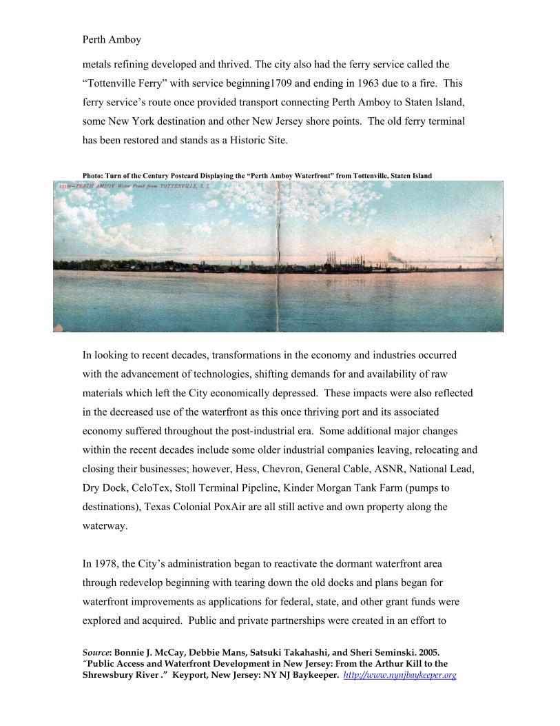
Photo: Turn of the Century Postcard Displaying the “Perth Amboy Waterfront” from Tottenville, Staten Island
In looking to recent decades, transformations in the economy and industries occurred
with the advancement of technologies, shifting demands for and availability of raw
materials which left the City economically depressed. These impacts were also reflected
in the decreased use of the waterfront as this once thriving port and its associated
economy suffered throughout the post-industrial era. Some additional major changes
within the recent decades include some older industrial companies leaving, relocating and
closing their businesses; however, Hess, Chevron, General Cable, ASNR, National Lead,
Dry Dock, CeloTex, Stoll Terminal Pipeline, Kinder Morgan Tank Farm (pumps to
destinations), Texas Colonial PoxAir are all still active and own property along the
waterway.
In 1978, the City’s administration began to reactivate the dormant waterfront area
through redevelop beginning with tearing down the old docks and plans began for
waterfront improvements as applications for federal, state, and other grant funds were
explored and acquired. Public and private partnerships were created in an effort to

Perth Amboy
Source: Bonnie J. McCay, Debbie Mans, Satsuki Takahashi, and Sheri Seminski. 2005. “Public Access and Waterfront Development in New Jersey: From the Arthur Kill to the Shrewsbury River .” Keyport, New Jersey: NY NJ Baykeeper. http://www.nynjbaykeeper.org
rebuild the City’s economy beginning with the waterfront. The Perth Amboy
Waterfront’s Development and economic viability continue today to be the focal point of
plans and activities.
Section 2: Perth Amboy Waterfront Use
2.1 Summary of Waterfront
Today, Perth Amboy’s waterfront area comprises three miles, half of which is owned by
the municipality and the remaining half owned by private industry. The waterfront area
of town has been designated as a Marine District. As stated earlier, the waterfront itself
consists of the Raritan River, the Arthur Kill, and the Raritan Bay.
At the waterfront, the public engages in both active
and passive recreation. The marina currently has
one privately-owned party boat, the “Sea Pigeon,”
for fishing and one privately owned dinner cruise
boat called the “Cornucopia Princess.”
Additionally, in April 2005 the Tallship Unicorn, a
118-foot long first class charter and sail training
boat, has moved to Perth Amboy’s Harborside Marina. There is also the “Seabra's
Armory Portuguese Restaurant” which opened in the mid-1980s. This restaurant is
located in the old ammunition “armory” building during World War 1 and World War 2.
Other recreational waterfront uses include social and civic events, special events such as
The Raritan Yacht Club's Red Grant Regatta, the Summer Breeze Jazz Cruise Concert
Series and the Concerts By the Bay, photography for weddings and other special
occasions, walking and jogging along the beach or the half mile waterfront walkway,
enjoying the beautiful views, fishing along the four fishing piers, sun-bathing, boating,
sailing, kayaking, flying kites or simply sitting on one of the many benches lining the
waterfront facing the water.
Harborside Waterfront Park Marina, Front Street, Perth Amboy, NJ

Perth Amboy
Source: Bonnie J. McCay, Debbie Mans, Satsuki Takahashi, and Sheri Seminski. 2005. “Public Access and Waterfront Development in New Jersey: From the Arthur Kill to the Shrewsbury River .” Keyport, New Jersey: NY NJ Baykeeper. http://www.nynjbaykeeper.org
There are also several commercial and industrial businesses in the city that depend on
waterfront access and the deep-water port. These businesses include the Perth Amboy
Yacht Club, Kinder Morgan, Hess, Chevron, and Co-Steel Painter.. .
At present, there are no bait shops or marine railway. Within the City’s redevelopment
plans, there are plans to add bait shops and more restaurants within the waterfront area.
Additionally, two thousand units of “Brownstone” style homes are being planned for the
“Landings at Harborside” development. The development is currently in its first phase.
According to the City’s Administration, the eventual completion of the $600 million, 49
acre project being developed by a private developer- Kushner Companies- will include:
2000 residential units, town-homes and mid-rise condominiums, 150,000 square-feet of
retail, a community cultural arts center, a public waterfront promenade, new parks, and
open spaces.
2.2 Waterfront Access
As noted earlier, the waterfront’s three mile length is currently half
owned by the municipality and half owned by private industry.
Public access to the municipally-owned waterfront is highly evident.
Based on interviews and site visits, there are signs all throughout the
municipally-owned waterfront. The City’s signs guide the public
towards the waterfront area. One brochure show photos and a walking map to guide
readers through sights of historic buildings listed on the federal historic registry
throughout Perth Amboy. (1993, City of Perth Amboy, “Old Perth Amboy Walking
Guide)
Still, signage in Perth Amboy will increase throughout the City’s waterfront area
including the newly redeveloped beaches noting the approved and intended public uses of
these amenities. Specifically, improvements in signage along the newer fishing piers are
Harborside Flag, Perth Amboy, NJ

Perth Amboy
Source: Bonnie J. McCay, Debbie Mans, Satsuki Takahashi, and Sheri Seminski. 2005. “Public Access and Waterfront Development in New Jersey: From the Arthur Kill to the Shrewsbury River .” Keyport, New Jersey: NY NJ Baykeeper. http://www.nynjbaykeeper.org
planned. The existing piers of waterfront near the marina on Front Street have adequate
signage but require maintenance due to frequency of missing signs.
Parking along the waterfront is available
in public lots, such as on Front Street,
Second Street and Sadowski Parkway,
and along city streets throughout the
waterfront area. Still, on weekends and for special waterfront events-like festivals,
holidays, and boating events- there is always a shortage of parking. Plans are being
explored by the municipality to expand the existing “trackless trolley system” to transport
tourists from off-site parking to the waterfront area during increased demand for parking
in the summer months.
Currently, there are also plans to improve connections to better link the city and its
community by way of the planned “Rt 440 -to- High Street extension” into the residential
development of “Harbortown” and “River View Drive” to connect to Sadowski Parkway.
Presently, no private residential owners have waterfront property due to the need to have
a protected area between the bulkhead and the Pier line. Residences and restaurants are
not permitted to line the docks. There are public access points to the waterfront all
throughout the municipally owned areas of the city. Specifically, there are open areas in
residential developments, such as “Harbortown,” the marina, Bayview Park, along
Sadowski Parkway, and in the future with the planned walkway/esplanade along the
stretch of waterfront from the fishing piers to the Outerbridge Crossing Bridge, and
within the plans for the mixed residential and commercial development called the
“Landings at Harborside.” The city’s vision is for all the existing waterfront and planned
redevelopment to have links to the waterfront.
Many shoreline improvements have been made with city, state and federal funds. There
are one and the half miles of waterfront walkway, four fishing piers (referred to as North
Parking Lot on Front Street, Perth Amboy, NJ

Perth Amboy
Source: Bonnie J. McCay, Debbie Mans, Satsuki Takahashi, and Sheri Seminski. 2005. “Public Access and Waterfront Development in New Jersey: From the Arthur Kill to the Shrewsbury River .” Keyport, New Jersey: NY NJ Baykeeper. http://www.nynjbaykeeper.org
fishing pier, South fishing pier, High Street fishing pier and Brighton Street fishing pier),
sunbathing beaches, parks and marina. Currently, there are no public boat launches and
swimming is not allowed. It is important to note that all of the land along the existing
waterfront is considered “park land” because “Green Acres” funds were used to acquire,
refurbish, and maintain it. Based on the guidelines “Green Acres” funds, these areas
must remain public.
Some portions of Perth Amboy’s waterfront are closed to the public due to private
industrial use and ownership.
Beach and Walkway, North Pier
Promenade Walkway, Front Street
Perth Amboy
Source: Bonnie J. McCay, Debbie Mans, Satsuki Takahashi, and Sheri Seminski. 2005. “Public Access and Waterfront Development in New Jersey: From the Arthur Kill to the Shrewsbury River .” Keyport, New Jersey: NY NJ Baykeeper. http://www.nynjbaykeeper.org
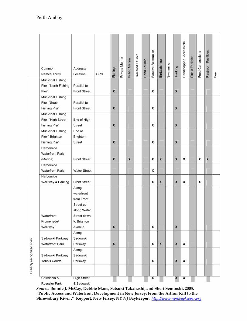
Common
Name/Facility
Address/
Location GPS
Fish
ing
Priv
ate
Mar
ina
Pub
lic M
arin
a
Trai
lere
d La
unch
Han
d La
unch
Pas
sive
Rec
reat
ion
Bird
wat
chin
g
Sw
imm
ing
Par
king
Han
dica
pped A
cces
sibl
e
Pic
nic
Faci
litie
s
Food
Con
cess
ions
Res
troom
Fac
ilitie
s
Fee
Municipal Fishing
Pier- “North Fishing
Pier”
Parallel to
Front Street X X X
Municipal Fishing
Pier- “South
Fishing Pier”
Parallel to
Front Street X X X
Municipal Fishing
Pier- “High Street
Fishing Pier”
End of High
Street X X X
Municipal Fishing
Pier-“ Brighton
Fishing Pier”
End of
Brighton
Street X X X
Harborside
Waterfront Park
(Marina) Front Street X X X X X X X X
Harborside
Waterfront Park Water Street X
Harborside
Walkway & Parking Front Street X X X X X
Waterfront
Promenade/
Walkway
Along
waterfront
from Front
Street up
along Water
Street down
to Brighton
Avenue X X X
Sadowski Parkway
Waterfront Park
Along
Sadowski
Parkway X X X X X
Sadowski Parkway
Tennis Courts
Along
Sadowski
Parkway X X X
Pub
licly
reco
gniz
ed s
ites
Caledonia &
Roessler Park
High Street
& Sadowski
X X X

Perth Amboy
Source: Bonnie J. McCay, Debbie Mans, Satsuki Takahashi, and Sheri Seminski. 2005. “Public Access and Waterfront Development in New Jersey: From the Arthur Kill to the Shrewsbury River .” Keyport, New Jersey: NY NJ Baykeeper. http://www.nynjbaykeeper.org
Parkway
Bayview Park Front Street X X X X X
Info
rmal
ly u
sed
and
acce
ssib
le
None
Seabra’s Armory
Portuguese
Seafood
Restaurant
200 Front
Street X X X X
Raritan Yacht Club
(RYC)
160 Water
Street X X X X X X X X
Chevron Industries
1200 State
Street
Hess Industries State Street
Priv
ate
Pro
perty
Kinder Morgan
Tank and Pumping
Station Industries
920 State
Street X
“Cornucopia
Princess” Dinner
Cruise Service
Sales Office
on Front
Street X X X X X X
Tallship Unicorn
Harborside
Marina X X
Oth
ers
Sea Pigeon
Fishing/Party Boat
Charter
Party Boat
Pier X X X X X X X X
Publicly recognized sites
North Fishing Pier: This is a municipally
owned fishing pier that runs parallel to
Front Street along the municipally owned
Harborside Waterfront Park Marina next to
the Seabra’s Armory Portuguese
Restaurant.

Perth Amboy
Source: Bonnie J. McCay, Debbie Mans, Satsuki Takahashi, and Sheri Seminski. 2005. “Public Access and Waterfront Development in New Jersey: From the Arthur Kill to the Shrewsbury River .” Keyport, New Jersey: NY NJ Baykeeper. http://www.nynjbaykeeper.org
Municipal Fishing Pier/“South Fishing Pier”: This is a municipally owned fishing pier
that runs perpendicular to Front Street along the municipally owned Harborside
Waterfront Park Marina by the Seabra’s Armory Portuguese Restaurant.
Municipal Fishing Pier/“High Street Fishing Pier”: This municipally owned fishing
pier is located at the end of High Street in the historical waterfront section of Perth
Amboy. There is an impervious bulk head at the base of the pier. This pier is also
referred to in planning documents as Groin #1. Each “Groin” serves as a pipe for
transporting water from storm sewers into the bay as needed, such as during peak storm
events.
Municipal Fishing Pier/“Brighton Fishing Pier”: This municipally owned fishing pier
is located at the end of Brighton Street in the historical waterfront section of Perth
Amboy. This pier is also referred to in planning documents as Groin #5. Each “Groin”
serves as a pipe for transporting water from storm sewers into the bay as needed, such as
during peak storm events.
Harborside Waterfront Park (Marina): Located along Front Street in Perth Amboy.
This park’s marina has 119 boats lips, two fishing piers (North Fishing Pier and South
Fishing Pier), a Harbor Master building with restrooms, benches, and walkways.
Harborside Waterfront Park: Located on Water Street. It has benches and walkways.
Harborside Walkway & Parking: Along the Harborside Waterfront Park (Marina) on
Front Street, there is also the Harborside walkway, benches and free-parking lots for
about 80 cars.
Waterfront Promenade/ Walkway: The City of Perth Amboy is continuing to maintain
and develop a Waterfront Promenade and Walkway. Currently, the promenade is along

Perth Amboy
Source: Bonnie J. McCay, Debbie Mans, Satsuki Takahashi, and Sheri Seminski. 2005. “Public Access and Waterfront Development in New Jersey: From the Arthur Kill to the Shrewsbury River .” Keyport, New Jersey: NY NJ Baykeeper. http://www.nynjbaykeeper.org
Front Street, Water Street, and along the Sadowski Parkway. Although the promenade is
not yet complete or contiguous, the length was stated to be about 7.6 miles in length.
Sadowski Parkway Waterfront Park:
Located along the Sadowski Parkway. The
park has a gazebo, benches, beaches,
fishing piers (High Street Fishing Pier and
Brighton Fishing Pier), and open areas.
Sadowski Parkway Tennis Courts: Located along the Sadowski Parkway across the
street from a stretch of Sadowski Parkway Waterfront Park. This park has bleachers,
tennis courts, and a recreation building.
Caledonia & Roessler Park: This park is located on the corner of High Street and
Sadowski Parkway. It is within within viewing distance of the water and has a baby
swing set, adult swing set, benches and a children’s play system.
Bayview Park: Located along Front Street. The park has a covered open-air pavilion
used as a bandstand, restrooms and benches.
Private Property
Seabra’s Armory Portuguese Seafood Restaurant: Located at 200 Front Street. It is a
spanish, Portuguese, seafood, barbeque restaurant. The restaurant uses some municipal
parking in the lot adjacent to its property.
Perth Amboy Yacht Club: The Raritan Yacht Club (RYC), an organization run by RYC
members for its members, is located at 160 Water Street. It was founded in 1865. The
Club’s main use is for sailing and social activities for the four hundred members. The
Club has a main building with a Grill Room containing a dining area and bar, the Surf

Perth Amboy
Source: Bonnie J. McCay, Debbie Mans, Satsuki Takahashi, and Sheri Seminski. 2005. “Public Access and Waterfront Development in New Jersey: From the Arthur Kill to the Shrewsbury River .” Keyport, New Jersey: NY NJ Baykeeper. http://www.nynjbaykeeper.org
Room containing a separate bar and sitting room, a few meeting rooms as well as the
Club offices and the galley. The Galley service is provided by a concessionaire.
The yard has restrooms and showers as well as lockers and dinghy storage racks. There is
boat storage in both summer and winter, available on a seniority basis. Members may use
the yard crane to launch trailed boats weighing up to 7,500 lbs. A gin pole for mast work
is also available.
Chevron Industries: Chevron Industries has a refinery in Perth Amboy surrounded the
Woodbridge Creek is to the north property border, the Arthur Kill is to the east, other
private industrial properties to the south and Route 35 (locally known as Convery Blvd)
to the west. The facility is located at 1200 State Street in Perth Amboy.
In operation since 1920, this facility reduced its business of petroleum refining in 1983 to
refining crude oil into asphalt cement and gasoline blending components and operates
wharf and storage facilities for crude oil, asphalt, and light hydrocarbon products. Today,
approximately 90 employees work on-site in operations, maintenance, technical, and
administration functions. The facility, formerly known as Chevron Products Company, is
a division of Chevron USA Incorporated.
According to a facility report by EPA, this 368 acres facility is responsible for releasing
contaminants into the surrounding waters. Assessment and clean-up plans continue to
date.
Hess Industries: The Hess Terminal, part of Amerada Hess Corporation, is located on
State Street in Perth Amboy and according to sources is the only company that still brings
ships up Raritan River.
Kinder Morgan Liquids Terminal: The Kinder Morgan Liquids Terminal (KMLT),
also referred to as tank-farms and pumping station, is located along the Authur Kill at 920
Perth Amboy
Source: Bonnie J. McCay, Debbie Mans, Satsuki Takahashi, and Sheri Seminski. 2005. “Public Access and Waterfront Development in New Jersey: From the Arthur Kill to the Shrewsbury River .” Keyport, New Jersey: NY NJ Baykeeper. http://www.nynjbaykeeper.org
State Street in Perth Amboy. It has one shipping dock, one barge dock, 104 tanks and
handles commodities of chemicals, petroleum, and cry bulk materials.
Other
“Cornucopia Princess” Dinner Cruise Service: Cornucopia Princess is a dinner cruise
liner and sight-seeing vessel docked at the foot of Smith Street at Front Street in Perth
Amboy. The vessel belongs to the Cornucopia Cruise Line which operates two vessels
for meal cruises and moonlight cruises. It is was established in 1998 and leases the old
Naval Marine Academy Complex from the City of Perth Amboy. Parking is available in
the nearby free-municipal parking lots adjacent to the dock.
Tallship Unicorn: In April 2005 the Tallship Unicorn, a 118-foot long first class charter
and sail training boat, has moved to Perth Amboy’s Harborside Marina. The Tallship
was open during the summer for public deck tours and private charters and will be
permanently moored in the marina.
Sea Pigeon Fishing/Party Boat: "Sea Pigeon" is a 75 foot Fishing/Party Boat docked
and running out of the Perth Amboy Waterfront Marina located on Front Street. Parking
is available in the nearby free-municipal parking lots adjacent to the dock.
Section 3: Waterfront Issues and Planning Initiatives
3.1 Waterfront Issues
Based on interviews and archival document reviews, Perth Amboy is experiencing major
redevelopment. Considering the focus of this study to identify and claim the coastal
commons in industrialized and gentrified places, the existing design and future plans
seem to be intent on providing public access; however, the area will incur added
congestion along its waterfront roadways already in need of additional parking amenities.

Perth Amboy
Source: Bonnie J. McCay, Debbie Mans, Satsuki Takahashi, and Sheri Seminski. 2005. “Public Access and Waterfront Development in New Jersey: From the Arthur Kill to the Shrewsbury River .” Keyport, New Jersey: NY NJ Baykeeper. http://www.nynjbaykeeper.org
Furthermore, evidence exists that the area is encountering gentrification as a by-product
of the rapid pace of progress with redevelopment plans throughout the City.
The planned development projects for increased commercial and residential development
may in fact lead to further gentrification as most of the current projects and pending
initiatives seek to infill and redevelop the area with high-end stores, restaurants, and
encourage more residential and light-use
industrial development. In the summer of 2005
the Tri-State Shipyard and Ship Repair
Industries, also referred to as the Perth Amboy
Dry Dock, was dismantled to make way for
residential development. This dry dock was one
of the last in the area that serviced tug-boats,
barges and naval vessels.
3.2 Planning Initiatives
Several documents exist proposing, endorsing and designing development plans, many of
which involve the waterfront area in Perth Amboy. The 2004 Master Plan’s Vision
includes new residential and mixed-use developments; Perth Amboy as a destination for
dining, entertainment and recreation; and improved access with new roads, ferry service
and bike and pedestrian routes. The Master Plan also includes as objectives preservation
of the history of Perth Amboy, creation of a maritime museum and increased access to
the waterfront and more waterfront amenities.
In 2005 Perth Amboy received $500,000 in Green Acres funding for improvements to the
Bayview Park. Improvements will include restoring the Park’s access steps and
reorienting the bandshell so that it features the waterfront as the backdrop. Perth Amboy
also recently spent over five million dollars on the Harborside Marina Waterfront Park.

Perth Amboy
Source: Bonnie J. McCay, Debbie Mans, Satsuki Takahashi, and Sheri Seminski. 2005. “Public Access and Waterfront Development in New Jersey: From the Arthur Kill to the Shrewsbury River .” Keyport, New Jersey: NY NJ Baykeeper. http://www.nynjbaykeeper.org
Some of the initiatives and proposed projects listed in the documents that may affect the
Perth Amboy waterfront include:
- The development of a shore trail along the Raritan Bay in Middlesex County connecting
with Monmouth County’s shore trail.
- Perth Amboy Focus 2000 includes three redevelopment areas:
• Redevelopment Area #1- the Riverview Center project which includes a
warehousing, office and restaurant along the Raritan River west of Second Street
• Redevelopment Area #2- the southern parcel between Pearl and Smith Streets will
be the site for the Landings at Harborside shoreline development that will include
2,000 dwelling units, a hotel, 150,000square feet of retail space and a cultural
center
• Redevelopment Area #3- shoreline parcel plan to be privately developed into an
Arenum (an arena and stadium) by the Bay with high tech office buildings, retail
and restaurants as well as the site for a ferry landing
-Three proposed ferry landings for Perth Amboy: (1) Arenum by the Bay with parking,
(2) site near the Victory Bridge (Route 35/Victory Bridge is currently being removed and
replaced) with parking, and (3) Harborside townhouses development for pedestrian
access only.
-Dredging (periodically) the deep sea port and waterways surrounding the Perth Amboy
waterfront to provide for shipping, water transportation, and recreational boating
-expanding marina and boat launch facilities
-Ferry transportation (as opposed to car, bus and light rail) to link areas of future
development along the Middlesex County shoreline
Perth Amboy
Source: Bonnie J. McCay, Debbie Mans, Satsuki Takahashi, and Sheri Seminski. 2005. “Public Access and Waterfront Development in New Jersey: From the Arthur Kill to the Shrewsbury River .” Keyport, New Jersey: NY NJ Baykeeper. http://www.nynjbaykeeper.org
- Increasing the capacity for recreational boating on the Arthur Kill/Raritan Bay to
increase tourism
- Expansion of the existing Perth Amboy City Marina from 119 to 140 boat slips along
Front Street
-Shoreline Improvement Project- the beaches have already been replenished with sand
and the 3 fishing piers have been constructed; plans for boat docks, boat launch and a dry
dock facility are still underway.
- Developing lodging in relation to plans for marina expansion in Perth Amboy
- Development of a waterfront trail to increase public access to the waterfront and
neighboring municipalities’ waterfronts and shorelines
- Increased public access and use of waterfronts will increase tourism and support any
new or enhanced commercial retail and entertainment facilities, which may increase job
opportunities within Arthur Kill/Raritan Bay region
- Development of housing in waterfront areas, such as Harbor Town expansion now up to
1,600 units, and the Landings at Harborside with 2,000 dwelling units, a hotel,
150,000square feet of retail space and a cultural center
- Permits and zoning adjustments to anticipate and redevelopment, improvements, in-fill
and development that will increase population and hit total build-out capacity
-Creation and coordination of strategic plans from regional level to county, municipality
and communities/neighborhoods.

Perth Amboy
Source: Bonnie J. McCay, Debbie Mans, Satsuki Takahashi, and Sheri Seminski. 2005. “Public Access and Waterfront Development in New Jersey: From the Arthur Kill to the Shrewsbury River .” Keyport, New Jersey: NY NJ Baykeeper. http://www.nynjbaykeeper.org
Section 4. Summary
This discussion has not been exhaustive. The plans, reports, documents, materials
referenced and interviews conducted can only paint with broad strokes the big picture.
This information can be used as a tool and certainly will require more observations,
assessments and examinations. It is apparent upon visiting Perth Amboy and its
waterfront area things are in full swing to change and transform amenities to build the
local economy, to bring in more tourists, attract a wealthier cohort of consumers and
potential residents into its City limits. Still, Perth Amboy’s Renaissance and various
partnerships between developers, municipalities and government officials may serve as
an “indicator” area for more study as lessons are learned and progress, as defined by the
current plans, continues to affect its residents, the waterfront and its usage, accessibility,
and other related matters.
References “City of Perth Amboy Master Plan Executive Summary,” January 2003, prepared by
Jacobs Environmental, Inc. and Heyer, Gruel & Associates, PA.
USGS Aerial Photo of Perth Amboy, 1995.
“Old Perth Amboy Walking Guide to Properties listed on the National Register of
Historic Places,” Sponsored by the Office of Economic & Community Development, 4th
Edition (revised) (1993).
Middlesex County Planning Department, Final Draft- Strategic Planning Area Plan
Report for Group One: The Arthur Kill, Raritan River and Raritan Bay Area and the
Metropark Area of Middlesex County, New Jersey (2003).
Perth Amboy Master Plan (1990).
Draft revised Master Plan (2004).