pest management strategy · 11.3.2 dingo risk management (canis lupus dingo) ... hunter region –...
TRANSCRIPT

PRELIMINARY DRAFT
Hunter Region
Pest Management Strategy
2008-2011

DRAFT © Department of Environment and Climate Change NSW 2007. You may copy, distribute, display, download and otherwise freely deal with this work for any purpose, provided that you attribute the Department as the owner. However, you must obtain permission if you wish to (1) charge others for access to the work (other than at cost), (2) include the work in advertising or a product for sale or (3) modify the work. Published by: Department of Environment and Climate Change NSW 59–61 Goulburn Street PO Box A290 Sydney South 1232 Ph: (02) 9995 5000 (switchboard) Ph: 131 555 (environment information and publications requests) Ph: 1300 361 967 (national parks information and publications requests) Fax: (02) 9995 5999 TTY: (02) 9211 4723 Email: [email protected] Website: www.environment.nsw.gov.au DECC 2007/xxx ISBN 978 1 74122 xxx x For further information contact: Regional Operations Coordinator Hunter Region Northern Branch Parks and Wildlife Group Department of Environment and Climate Change 12B Teramby Rd Nelson Bay 2317 NSW Telephone: 02 4984 8200 Cover photo: DECC This plan should be cited as follows: Department of Environment and Climate Change NSW. (2007). Hunter Region Pest Management Strategy 2007-2010. DECC, Sydney, NSW The New South Wales National Parks and Wildlife Service (NPWS) is now part of the Department of Environment and Climate Change (DECC). Throughout this strategy, references to “NPWS” should be taken to mean the NPWS carrying out functions on behalf of the Director General and the Minister of DECC.

DRAFT Table of Contents 1 Introduction .............................................................................................................1 2 Purpose of the Strategy ..........................................................................................1 3 Legislation and Policy .............................................................................................2 4 Regional Overview ..................................................................................................5
4.1 New Reserves and Additions........................................................................................... 6 5 Pest Distribution Tables ..........................................................................................8 6 Pest Management Objectives ...............................................................................14 7 Pest Management Principles ................................................................................14 8 Pest Program Priorities .........................................................................................15 9 Pest Program Recording and Monitoring ..............................................................16
9.1 Recording....................................................................................................................... 16 9.2 Monitoring ...................................................................................................................... 17
10 Regional Coordination and Support of Pest Control Programs...........................18 11 Pest Program Overviews ....................................................................................19 11.1 Weed Species ....................................................................................................19
11.1.1 Aquatic Weeds.......................................................................................................... 19 11.1.2 Asparagus Species ................................................................................................... 20 11.1.3 Bitou Bush (Chrysanthemoides monilifera ssp. rotundata) ...................................... 21 11.1.4 Blackberry (Rubus fruticosus agg.)........................................................................... 23 11.1.5 Coastal Environmental Weeds ................................................................................. 24 11.1.6 Crofton Weed (Ageratina adenophora) and Mistflower (A. riparia) .......................... 25 11.1.7 Exotic Grasses.......................................................................................................... 25 11.1.8 Exotic Herbs.............................................................................................................. 27 11.1.9 Exotic Vines and Scramblers .................................................................................... 28 11.1.10 Lantana (Lantana camara)...................................................................................... 29 11.1.11 Prickly Pear (Opuntia stricta) and Tiger Pear (O. aurantiaca) ................................ 30 11.1.12 Scotch Broom (Cytisus scoparius).......................................................................... 31 11.1.13 Woody Weeds......................................................................................................... 32
11.2 Pest Animal Species ..........................................................................................33 11.2.1 European Rabbit (Oryctolagus cunniculus) .............................................................. 33 11.2.2 European Red Fox (Vulpes vulpes).......................................................................... 34 11.2.3 Feral Cat (Felis catus)............................................................................................... 35 11.2.4 Feral Deer (Various species) .................................................................................... 35 11.2.5 Feral Goat (Capra hircus) ......................................................................................... 36 11.2.6 Feral Horse (Equus caballus) ................................................................................... 37 11.2.7 Feral Pig (Sus scrofa) ............................................................................................... 38 11.2.8 Wild Dog (Canis lupus familiaris) .............................................................................. 39
11.3 Other Pest Related Issues .................................................................................40 11.3.1 Community Bush Regeneration Programs ............................................................... 40 11.3.2 Dingo Risk Management (Canis lupus dingo) .......................................................... 40 11.3.3 Plant Pathogen (Phytophthora cinnamomi) .............................................................. 41 11.3.4 Bell Miner Associated Dieback (BMAD) ................................................................... 42
12 References............................................................................................................43 Appendix 1 – Pest Control Priorities for each Management Area.................................... 45 Appendix 2 – Declared Weeds......................................................................................... 53

DRAFT
Hunter Region – Pest Management Strategy 2007-2010 Page 1
1 Introduction Pest species are animals (including invertebrates) and plants that have negative environmental, economic and social impacts. In this document they are collectively referred to as pests. Pests are most commonly introduced species, though native species can become pests. In parks, pests may have impacts across the range of park values, including impacts on biodiversity, cultural heritage, catchment and scenic values.
Pests are among the greatest threats to biodiversity throughout Australia. In New South Wales, they have been identified as a threat to 657 of 945 (70%) species, populations and communities listed under the Threatened Species Conservation Act 1995; more than any other process except the destruction and disturbance of native vegetation. Minimising the impacts of pests on biodiversity is thus the main objective of NPWS pest management.
Pests can also have significant impacts on economic values of neighbouring lands. The NPWS seeks to address these impacts when setting management priorities and significant resources are committed towards landscape wide pest programs, including wild dogs.
The control of pests outside of parks is the responsibility of private landholders and other agencies such as rural lands protection boards, local councils, the Department of Primary Industries and the Department of Lands. The NSW Invasive Species Plan provides the framework for the coordinated management of weeds and pests that occur over varying land tenure. NPWS is a committed partner to the implementation of this plan.
Many pests are distributed widely across Australia and eradication is not possible in the foreseeable future. They occur in most environments and across all land tenures. Pests often spread quickly and have high reproductive rates, allowing them to re-establish rapidly following control. In recognising that eradication of widespread pests across large areas is an unrealistic goal, NPWS prioritises control effort to focus on areas where impacts are greatest. Resources can then be directed to ensure that the resultant control programs are effective in reducing these impacts. It is the responsibility of all land managers to work together to control pests where significant impacts have been identified.
In New South Wales, the main pest management priorities for the conservation of biodiversity are focussed on threatened species and endangered ecological communities, and are identified in the Threatened Species Priorities Action Statement (PAS), individual threat abatement plans (TAPs) and reserve plans of management. Pest programs are also integrated with other park management programs such as fire management.
2 Purpose of the Strategy The development of Regional Pest Management Strategies (RPMS) provides NPWS with a strategic approach to pest management across NSW. The Strategy developed for each region provides a tool to broadly identify pest distribution and their associated impacts across the park system. It details priorities for each Region, including actions listed in the PAS and TAPs as well as other actions such as wild dog and feral pig control to protect neighbouring properties and site-based weed control and allows resources to be allocated to high priority programs. The RPMS
DRAFT
Hunter Region – Pest Management Strategy 2007-2010 Page 2
also identifies the requirement for other plans or strategies, such as Wild Dog Plans or Bush Regeneration Plans that provide a more detailed approach.
New pest species continue to establish in the environment either through the importation of new species into Australia or the escape of domestic plants and animals. Prevention and early detection followed by eradication is the most cost-effective way to minimise the impacts of new pests. The NPWS works with other agencies to prevent the introduction of new pests into the wild and to respond rapidly when new incursions occur. The response of NSW government agencies to new pests will be coordinated through the NSW Invasive Species Plan.
In this strategy, the generic term “parks” is used to refer to any lands managed by NPWS including national park, nature reserve, Aboriginal area, historic site, state conservation area and regional park amongst others. This strategy has a four year life span. In the final year of the strategy, it is intended that the strategy will be reviewed and updated.
3 Legislation and Policy The NPWS has a number of statutory responsibilities in relation to pest management.
National Parks and Wildlife Act 1974 The National Parks and Wildlife Act 1974 (NPW Act) vests the care, control and management of national parks, nature reserves, historic sites and Aboriginal areas with the Director-General of the NPWS. Key management objectives include conservation, provision of appropriate scientific and educational opportunities, and management of fire and pest species. These are achieved through the preparation and implementation of plans of management for each reserve, which identify pest species present, control strategies and priorities for that reserve.
Threatened Species Conservation Act 1995 The NSW Threatened Species Conservation Act 1995 (TSC Act) lists threatened species, endangered populations and endangered ecological communities. The TSC Act also lists key threatening processes (KTPs), which are identified as having significant impacts on the conservation of native flora and fauna. As of August 2006, 18 pests have been listed as KTPs e.g. Predation by the Red Fox, Invasion of Native Plant Communities by Bitou Bush and Boneseed. The NSW Threatened Species Priorities Action Statement (PAS) outlines the strategies for ameliorating threats listed under the TSC Act including the preparation of TAPs. For each of these strategies the PAS lists one or more detailed actions which aim to protect threatened species by reducing the impact of listed threats.
Rural Lands Protection Act 1998 The pest animal provisions of the Rural Lands Protection Act 1998 (RLP Act) outline the conditions under which animals, birds and insects are "declared" pests and provides for the control of such pest species. Gazettal of pest species occurs through Pest Control Orders that allow the Minister for Primary Industries to specify pest species on a state wide or local basis and the conditions or factors that apply to the control of each pest. Rabbits, wild dogs and feral pigs have been declared pest animals throughout NSW.
The RLP Act binds the Crown for the control of pest animals declared under the Act. Public land managers such as the NPWS are required to eradicate (continuously suppress and destroy) pest animals "…to the extent necessary to minimise the risk of

DRAFT
Hunter Region – Pest Management Strategy 2007-2010 Page 3
the pest causing damage to any land" using any lawful method or, if the Order specifies a method to be used, by the method specified.
An approach to balance the conservation of dingoes with the need for wild dog control has been incorporated into the RLP Act through the Pest Control Order for Wild Dogs. This order allows for the general destruction obligation for lands listed in Schedule 2 of the order to be satisfied through wild dog management plans with both control and conservation objectives.
Noxious Weeds Act 1993 The Noxious Weeds Act 1993 provides for the identification, classification and control of noxious weeds in New South Wales. The Act aims to identify noxious weeds and their respective control measures, as well as the roles and responsibilities for their control for both public and private land managers/owners.
Amendments to the Noxious Weeds Act in 2005 repealed the NSW Seeds Act 1982 and introduced a new classification system of weed control classes based on the degree of threat and the distribution of the introduced plant within the state. These new control classes are:
Control Class 1 – State Prohibited Weeds Control Class 2 – Regionally Prohibited Weeds Control Class 3 – Regionally Controlled Weeds Control Class 4 – Locally Controlled Weeds Control Class 5 – Restricted Plants. Under this new classification system, Control Classes 1, 2 and 5 noxious weeds are referred to as notifiable weeds.
Pesticides Act 1999 The Pesticides Act 1999 and the Pesticides Regulation 1995, regulate the use of all pesticides in NSW, after point of sale, and includes specific provisions for record keeping, training and notification of use.
Specific requirements have been included under the Pesticides Regulation in relation the following.
Pesticide Record Keeping: Records must be kept by all people who use pesticides for commercial or occupational purposes such as on farm or as part of their occupation or business. There are also specific record keeping provisions for persons who aerially apply pesticides under both the Act and regulations.
Pesticides Training: People who use pesticides in their business or as part of their occupation must be trained how to use these pesticides. Any person employed or engaged by NPWS to use pesticides must also be trained.
Pesticide Notification: Notification requirements apply to pesticide applications by public authorities in public places (including NPWS managed park lands). The NPWS Pesticide Use Notification Plan sets out how the Department will notify the community about pesticide applications it makes to public places. (The plan can be located on the NPWS web site).
Pesticide Control Orders are orders that prohibit or control the use of a pesticide or a class of pesticide, or authorise the use or possession of a restricted pesticide e.g. 1080.
Use of a pesticide must be in accordance with the Control Order where such exists. Current Control Orders can be found at:
www.environment.nsw.gov.au/pesticides/pco.htm.

DRAFT
Hunter Region – Pest Management Strategy 2007-2010 Page 4
Game and Feral Animal Control (Game) Act 2002 The major aim of the Game and Feral Animal Control Act 2002 (Game Act) is to promote responsible and orderly hunting of game animals and certain pest animals. The public lands that are covered by this Act do not include any national park estate land.
Other Relevant Legislation • Environment Protection and Biodiversity Conservation Act 2000 (Australian) • Agricultural and Veterinary Chemicals Code Act 1994 • Environmental Planning and Assessment Act 1979 • Firearms Act 1996 • Heritage Act 1977 • Prevention of Cruelty to Animals Act 1979 • Occupational Health and Safety Act 2000 • Wilderness Act 1987 • Protection of the Environment Operations Act 1997 Park Management Program and policies The Park Management Program is a series of guides which are being developed to define the values and objectives for park management and to integrate park policy, planning, operations, monitoring, evaluation and reporting. The aims of the guides are to improve the way we go about park management by: • providing clear and consistent management objectives and operational
procedures, and • introducing a system to achieve consistent standards in park management and
reporting on performance.
The Park Management Program comprises a Policy Guide, a Planning Guide, an Operating Procedures Guide and a Monitoring and Evaluation Guide.
The Policy Guide describes the goals and objectives for park management and the key principles which are applied to guide the achievement of these objectives.
Some specific policies relating to the management of weeds and pest animals are mentioned below.
Policy 2.6 Wild Dogs acknowledges the complexities inherent in the need to conserve native dingoes (and their hybrids) together with the need to control wild dogs.
The NPWS Firearms Management Manual brings together the policy, procedural and technical information required for staff regarding the safety, security and legal procedures for keeping and using firearms. The manual replaced the NPWS Firearms Policy and provides policy and procedures for all aspects of firearms use and management including: • possession and use of firearms by NPWS staff and other approved users, • firearms administration and record keeping, • location and storage of firearms, • planning and risk management for firearms operations, • maintenance and modification of firearms, • animal welfare issues related to shooting pest animals and euthanasing native
animals, and • firearms training.
DRAFT
Hunter Region – Pest Management Strategy 2007-2010 Page 5
A statewide policy directive requires conservation risk assessments for the application of pesticides on park to ensure that an appropriate level of environmental assessment is carried out prior to application.
Other plans Other plans that help direct pest management may include Catchment Action Plans for each of the 13 Catchment Management Authorities, regional weed plans, state and national strategies, and reserve Plans of Management.
4 Regional Overview
The Hunter Region of NPWS currently covers parts of the Hunter, Peel and Manning Valleys. The region extends from Merewether in the south to Tuncurry in the north and extends inland to Merriwa and Quirindi. The Hunter Region includes the city of Newcastle and surrounding suburbs. The total residential population of the region exceeds 400 000 and it is estimated two-thirds of park visitors come from this population.
The region is divided into five management areas, Hunter Coast, Newcastle, Barrington Tops, Great Lakes and Upper Hunter. Hunter Region manages 220 000 hectares of lands including 12 national parks, 11 state conservation reserves, 46 nature reserves and 2 regional parks (Figure 1).
The Hunter Region was one of the first areas in NSW cleared for agricultural purposes, thus a wide range of plants and animals have been introduced. In addition to landuse changes, the geology, the altitudinal range from the coast to sub-alpine, and the variation in landuse including rural, semi-rural, urban and natural areas, all contribute to a wide variety of pest management issues.
Pest issues in the rural areas of the upper Hunter and Barnard catchments are associated with impacts from vertebrate pests. Coordinated cooperative programs with neighbours and the Hunter, Maitland, Armidale and Gloucester Rural Lands Protection Boards are implemented to reduce populations of wild dog, fox and feral pigs in key areas including Barrington Tops, Curracabundi, Ben Halls Gap and Towarri National Parks and Tomalla, Back River, Woolooma and Wallabadah Nature Reserves.
The implementation of the NSW Fox Threat Abatement Plan has lead to control programs to protect populations of the endangered broad-toothed rat in Barrington Tops NP and the brush-tailed rock wallaby in Woko and Curracabundi NPs. A component of these programs includes annual population monitoring of the species at risk.
An annual fox / wild dog program is coordinated on public lands across the Port Stephens Local Government Area to reduce predation on koala populations. Other cooperative fox control programs are undertaken in the Hunter Estuary to protect migratory wader habitat.
Biodiversity impacts from weeds such as bitou bush, scotch broom, lantana, exotic vines and alligator weed are being addressed by the implementation of weed control programs in locations where threatened species and / or endangered ecological communities occur.
Coordinated landscape programs have been implemented in coastal reserves with Great Lakes, Lake Macquarie, Newcastle and Port Stephens Local Government

DRAFT
Hunter Region – Pest Management Strategy 2007-2010 Page 6
Areas for coastal weeds such as bitou bush. These programs have improved the long term success of weed control by removing weeds across land tenure.
Island recovery weed control programs have commenced at Snapper Island and John Gould NRs and Broughton Island in Myall Lakes NP to protect threatened ecological communities such as Littoral Rainforest and Themeda coastal clay grasslands.
The involvement of community bush regeneration groups in coastal reserves is integral to the success of weed control programs in Glenrock SCA, Shelly Beach in Booti Booti NP and Seal Rocks in Myall Lakes NP.
A number of research and monitoring programs for scotch broom, bitou bush, fox TAP projects and wild dogs are also being undertaken in coordination with various universities, other Government agencies and the Weeds and Pest Invasive Animals Cooperative Research Centres.
4.1 New Reserves and Additions At the time of publication of this Regional Pest Management Strategy (RPMS), the land managed by Hunter Region NPWS has expanded by approximately 12 000 ha. Currently most of these areas have not been investigated for weed and vertebrate pest issues. During the life of the RPMS (2008-2011), surveys will be undertaken and pest management plans developed and implemented. Priorities for control will be considered within the context of existing pest programs in the region, as well as the available resources. Newly gazetted lands include lower Hunter lands in Hunter Coast Area (HCA), Newcastle Area (NCA) and Barrington Tops Area (BTA). They include:
- Worimi Conservation Lands (previously recognised as Stockton Bight / Beach), incorporating Worimi NP, SCA and RP. Gazetted February 2007. - Tilligerry NP and SCA (HCA); - Hunter Wetlands NP (incorporating existing reserves Kooragang and Hexham NRs) (NCA); - Additions to Karuah NP, Medowie SCA and Tomaree NP (HCA); and Columbey NP (BTA).
The Port Stephens – Great Lakes Marine Park (PSGLMP) was declared in December 2005 and covers an area of 98,000 hectares, including offshore waters to the 3 nautical mile limit of state waters between Cape Hawke Surf Life Saving Club and Birubi Headland and all the estuarine waters and tributaries (to the tidal limit) of Port Stephens, Myall Lakes and Smith Lakes. The Marine Parks Authority in April 2007 became part of the Parks & Wildlife Division. The PSGLMP is now part of the Hunter Region. Assessment of pest management issues in the Marine Park will be considered in the future as part of the RPMS.

DRAFT
Hunter Region – Pest Management Strategy 2007-2010 Page 7

DRAFT
Hunter Region – Pest Management Strategy 2007-2010 Page 8
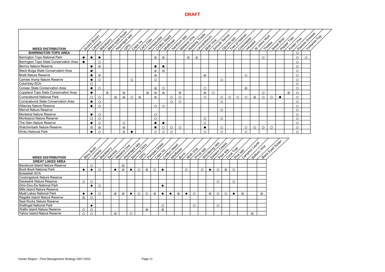
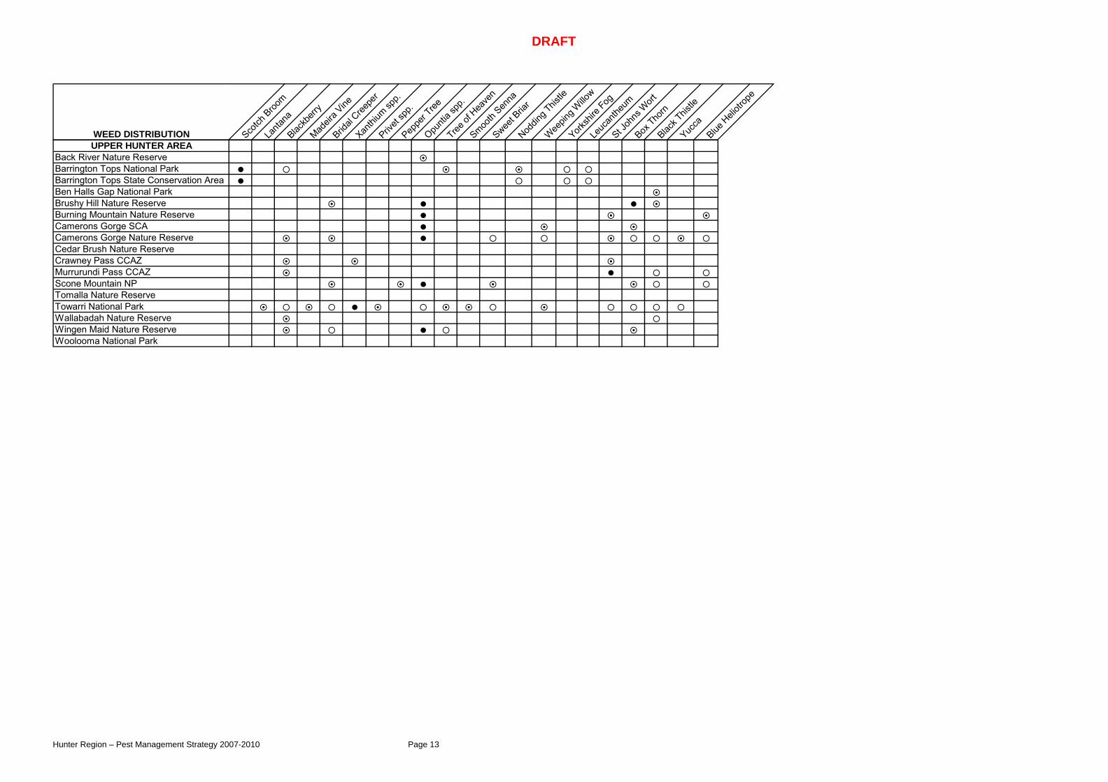
5 Pest Distribution Tables Pest distribution tables give an overview of priority pest species for each reserve within the Region. The data is derived from a combination of systematic surveys, consultation with staff and other agencies and through planning processes. The tables are not comprehensive lists of all pest species but focus on new incursions or on pests which are having environmental, cultural, agriculture or social impacts in the Region. Due to the size of these lists they have been included as Appendix 1.
Denotes established widespread populations throughout a reserve Denotes scattered populations throughout a reserve Denotes isolated populations restricted to a small geographic area of a reserve
VERTEBRATE PEST DISTRIBUTION Wild do
g
Fox Feral p
ig
Rabbit
Horse
Goat
Deer
Cat
BARRINGTON TOPS AREABarrington Tops National ParkBarrington Tops State Conservation AreaBerrico Nature ReserveBlack Bulga State Conservation AreaBretti Nature ReserveCamels Hump Nature ReserveColumbey SCA Coneac State Conservation AreaCopeland Tops State Conservation AreaCurracabundi National ParkCurracabundi State Conservation AreaKillarney Nature ReserveMernot Nature ReserveMonkerai Nature ReserveMonkeycot Nature ReserveThe Glen Nature ReserveWatchimbark Nature ReserveWoko National Park
VERTEBRATE PEST DISTRIBUTION Wild do
g
Fox Feral p
ig
Rabbit
Horse
Goat
Deer
Cat
GREAT LAKES AREABandicoot Island Nature ReserveBooti Booti National ParkBuladelah SCACoolongolook Nature ReserveDarawank Nature ReserveGhin-Doo-Ee National ParkMills Island Nature ReserveMyall Lakes National ParkRegatta Island Nature ReserveSeal Rocks Nature ReserveWallingat National ParkWallis Island Nature ReserveYahoo Island Nature Reserve

DRAFT
Hunter Region – Pest Management Strategy 2007-2010 Page 9
VERTEBRATE PEST DISTRIBUTION Wild do
g
Fox Feral p
ig
Rabbit
Horse
Deer
Cat Black R
at
Carp
HUNTER COAST AREABoondelbah Nature ReserveBushy Island Nature ReserveBroughton Island (MLNP)Corrie Island Nature ReserveGir-um-bit NR (Fame Cove)Gir-um-bit NRJohn Gould NR (Cabbage Tree Is) Karuah National Park (Wallaroo)Karuah Nature ReserveKaruah State Conservation AreaLittle Broughton Island Nature ReserveMedowie State Conservation AreaMoffats Swamp Nature ReserveOne Tree Island Nature ReserveSeaham Swamp Nature ReserveSnapper Island Nature ReserveWorimi Regional ParkStormpetrel Nature ReserveTilligerry Nature ReserveTilligerry National ParkTomaree National ParkWorimi National ParkWorimi State Conservation Area
VERTEBRATE PEST DISTRIBUTION Wild do
g
Fox Feral p
ig
Rabbit
Cat Black R
at
NEWCASTLE AREAAwabakal Nature ReserveBlue Gum Hills Regional ParkGlenrock State Conservation AreaHunter Wetland NP (Hexham Swamp)Hunter Wetland NP (Kooragang)Pambalong Nature Reserve

DRAFT
Hunter Region – Pest Management Strategy 2007-2010 Page 10
VERTEBRATE PEST DISTRIBUTION Wild do
g
Fox Feral p
ig
Rabbit
Horse
Goat
Deer
Cat
UPPER HUNTER AREABack River Nature ReserveBarrington Tops National ParkBarrington Tops State Conservation AreaBen Halls Gap National ParkBrushy Hill NRBurning Mountain Nature ReserveCamerons Gorge Nature ReserveCedar Brush Nature ReserveCrawney Pass CCAZMurrurundi Pass CCAZScone Mountain NPTomalla Nature ReserveTowarri National ParkWallabadah Nature ReserveWingen Maid Nature ReserveWoolooma National Park
DRAFT
Hunter Region – Pest Management Strategy 2007-2010 Page 11
WEED DISTRIBUTION Scotch
Broo
mLa
ntana
Blackb
erry
Black-e
yed S
usan
Aspara
gus s
pp.
GPGCap
e Ivy
Cat's C
lawHon
eysu
ckle
Crofton
Wee
dMist
flower
Xanthi
um sp
p.
Madeir
a Vine
Noddin
g This
tle
Leuc
anthe
umMoth
VineSmoo
th Sen
naOpu
ntia s
pp.
Tree of
Hea
ven
Cotone
aster
Inkwee
dSt J
ohns
Wort
Thistle
sSwee
t Bria
rPep
per T
reePota
to Vine
Pastur
e Gras
ses
Yorksh
ire Fog
BARRINGTON TOPS AREABarrington Tops National ParkBarrington Tops State Conservation AreaBerrico Nature ReserveBlack Bulga State Conservation AreaBretti Nature ReserveCamels Hump Nature ReserveColumbey SCAConeac State Conservation AreaCopeland Tops State Conservation AreaCurracabundi National ParkCurracabundi State Conservation AreaKillarney Nature ReserveMernot Nature ReserveMonkerai Nature ReserveMonkeycot Nature ReserveThe Glen Nature ReserveWatchimbark Nature ReserveWoko National Park
WEED DISTRIBUTION Bitou B
ush
Lanta
naBlac
kberr
ySalv
inia
Madeir
a Vine
Aspara
gus s
pp.
Morning
Glor
yGPGPam
pas G
rass
Cape I
vyCrof
ton W
eed
Mistflo
werBurr
sMoth
VinePriv
et sp
p.Wan
derin
g Jew
Easter
n Cas
sia
Pear s
pp.
Coral T
reePine
spp.
Camph
or La
urel
Balloo
n Vine
Black E
yed S
usan
GREAT LAKES AREABandicoot Island Nature ReserveBooti Booti National ParkBuladelah SCACoolongolook Nature ReserveDarawank Nature ReserveGhin-Doo-Ee National ParkMills Island Nature ReserveMyall Lakes National ParkRegatta Island Nature ReserveSeal Rocks Nature ReserveWallingat National ParkWallis Island Nature ReserveYahoo Island Nature Reserve

DRAFT
Hunter Region – Pest Management Strategy 2007-2010 Page 12
WEED DISTRIBUTION Bitou B
ush
Lanta
naBlac
kberr
yWate
r Hya
cinth
Aspara
gus s
pp.
Morning
Glor
y
Bridal
Creepe
r
Pampa
s Gras
s
Crofton
Wee
d/Mist
flower
Polyga
laXan
thium
spp.
Moth Vine
Easter
n Cas
sia
Formos
a Lily
Opunti
a spp
.Cam
phor
Laure
l
Coral T
reePap
yrus
Spiny B
urr G
rass
Kikuyu
Garden
esca
pes
Pine Turkey
Rhu
barb
Chrithm
um m
aritim
un
HUNTER COAST AREABoondelbah Nature ReserveBushy Island Nature ReserveBroughton Island (MLNP)Corrie Island Nature ReserveGir-um-bit NR (Fame Cove )Gir-um-bit NRJohn Gould Nature Reserve (Cabbage TreKaruah National Park (Wallaroo)Karuah Nature ReserveKaruah State Conservation AreaLittle Broughton Island Nature ReserveMedowie State Conservation AreaMoffats Swamp Nature ReserveOne Tree Island Nature ReserveSeaham Swamp Nature ReserveSnapper Island Nature ReserveStormpetrel Nature ReserveTilligerry Nature ReserveTilligerry National ParkTomaree National ParkWorimi National ParkWorimi State Conservation AreaWorimi Regional Park
WEED DISTRIBUTION Bitou B
ush
Lanta
naBlac
kberr
yWate
r Hya
cinth
Madeir
a Vine
Aspara
gus s
pp.
Alligato
r Wee
dMorn
ing G
lory
Pampa
s Gras
s
Cape I
vyCrof
ton W
eed/M
istflo
wer
Balloo
n Vine
Moth V
inePriv
et sp
p.Wan
derin
g Jew
Easter
n Cas
sia
Formos
a Lily
Opunti
a spp
.Cam
phor
Laure
l
Coral T
reeWillo
wParr
ots Fea
ther
Kikuyu
Garden
esca
pes
Turkey
Rhu
barb
NEWCASTLE AREAAwabakal Nature ReserveBlue Gum Hills Regional ParkGlenrock State Conservation AreaHunter Wetlands NP (Hexham Swamp)Hunter Wetlands NP (Kooragang)Pambalong Nature Reserve
DRAFT
Hunter Region – Pest Management Strategy 2007-2010 Page 13
WEED DISTRIBUTION Scotch
Broom
Lanta
naBlac
kberr
yMad
eira V
ineBrid
al Cree
per
Xanthi
um sp
p.
Privet
spp.
Peppe
r Tree
Opunti
a spp
.Tree
of H
eave
n
Smooth
Senna
Sweet B
riar
Noddin
g This
tle
Weepin
g Willo
w
Yorksh
ire Fog
Leuc
anthe
umSt J
ohns
Wort
Box Tho
rnBlac
k This
tleYuc
caBlue
Heli
otrop
e
UPPER HUNTER AREABack River Nature ReserveBarrington Tops National ParkBarrington Tops State Conservation AreaBen Halls Gap National ParkBrushy Hill Nature ReserveBurning Mountain Nature ReserveCamerons Gorge SCACamerons Gorge Nature ReserveCedar Brush Nature ReserveCrawney Pass CCAZMurrurundi Pass CCAZScone Mountain NPTomalla Nature ReserveTowarri National ParkWallabadah Nature ReserveWingen Maid Nature ReserveWoolooma National Park
DRAFT
Hunter Region – Pest Management Strategy 2007-2010 Page 14
6 Pest Management Objectives The overriding objective of NPWS’s pest management programs is to minimise adverse impacts of pests on biodiversity and other park values whilst complying with legislative responsibilities.
Programs also aim to: • manage pest populations to minimise their impact on neighbours, • increase community understanding of the adverse impacts of pests on
biodiversity and Aboriginal and historic cultural heritage, and • support cooperative approaches and participation in pest management programs
with the community and other agencies.
7 Pest Management Principles Wherever possible, NPWS adopts an integrated approach to pest management, where more than one control technique is used across the landscape. Integrated pest management is likely to be more effective because it avoids selecting for herbicide resistant weed biotypes or bait-shy animals. Targeting more than one pest species is important as the control of one species may benefit another e.g. control of foxes may benefit rabbits; control of bitou bush often leads to an increase in other weeds. Also, control is usually undertaken at particular times of the year when pests are most vulnerable (e.g. translocation of herbicides to growing points is usually greater when weeds are flowering).
So that pest management undertaken by the NPWS is carried out effectively and efficiently, the following principles are generally applied.
• Pest control is targeted to species/locations where benefits will be greatest.
• Development of control priorities are set by clearly defining the problem to be addressed i.e. specific impacts are identified so that the purpose of control is clear.
• Where relevant, pest control is collaborative and across tenure, that is, undertaken on a landscape approach.
• Early detection of new incursions and rapid response is considered a high priority as this is the most cost-effective form of pest control.
• Priority is given to mitigating the impacts on biodiversity of a pest that has cultural significance, whilst minimising impacts on cultural values.
• The aim of most pest control programs is to minimise the adverse impacts of pests, as many exotic pests are already widespread (e.g. foxes, blackberries) and for these species eradication is not possible.
• The focus of control programs is directed towards the values to be protected, because killing pests, by itself, does not necessarily minimise their impacts due to the fact that ecological processes are complex and can be affected by a range of factors.
• Risk assessments are undertaken prior to pest control, where required.
• Pest management strives to strike a balance between cost efficiency, target specificity and animal welfare.
• Where appropriate, pest control employs a combination of control methods and strategies (integrated pest management).

DRAFT
Hunter Region – Pest Management Strategy 2007-2010 Page 15
• Pest control programs take a holistic approach, given that the control of one pest may benefit other pests, in that they attempt to control all significant pest threats at a site.
• Pesticide use complies with relevant legislation and is employed in a manner that minimises impacts on the environment.
• Pest management programs are often integrated with other land management activities such as fire management and recreation management.
• Monitoring is being implemented, at varying levels, to demonstrate and improve the ongoing effectiveness of control programs.
8 Pest Program Priorities NPWS prioritises its pest control programs to focus on those areas where the impacts of pests are likely to be greatest. Resources can then be directed to ensure that the resultant control programs are effective in reducing these impacts. The availability of suitable control techniques and resources (both financial and physical), as well as the practicality and cost effectiveness of control, also influence which programs can be implemented.
Where new pest incursions occur, early detection and eradication is the most cost-effective way to minimise the impacts. The NPWS will work with other agencies to prevent the introduction of new pests and to respond rapidly when new incursions occur.
The following key factors are considered when determining priorities for pest management within the Region.
Critical Priority
1. Programs targeting pests which are, or are likely to be, significantly impacting on biodiversity, as largely identified in the NSW Threatened Species Priorities Action Statement e.g. undertake fox control on the Barrington Tops plateau to protect endangered population of the broad-toothed rat.
2. Programs that target pests which impact significantly on human health or are part of a declared national emergency e.g. outbreak of foot and mouth disease.
3. Programs targeting pests that impact significantly on agricultural production e.g. wild dog control where there is potential for significant stock losses as identified in Wild Dog Management Plans; programs to control State Prohibited or Regionally Prohibited Noxious Weeds (Control Class 1 and 2 weeds).
4. Programs addressing new occurrences of highly invasive pest species with potential for significant impacts on park values (subject to risk/feasibility assessment) e.g. control of Leucantheum in Barrington Tops NP or gloriosa lily in coastal reserves.
High Priority
5. Programs that target pests (other than those covered in priorities above) that impact significantly on World Heritage or international heritage values, e.g. control of crofton weed / mistflower in Jerusalem Creek / Williams River Barrington Tops NP.
6. Programs targeting pests that impact significantly on important cultural heritage values e.g. control of weeds in old colliery sites in Glenrock SCA.

DRAFT
Hunter Region – Pest Management Strategy 2007-2010 Page 16
Medium Priority
7. Programs that target pests (other than those covered in priorities above) that impact significantly on Wilderness, Wild Rivers, national heritage values or other important listed values e.g. control of willows along a declared Wild River or within a Wilderness Area.
8. Programs that target pests that impact significantly on recreation, landscape or aesthetic values, e.g. control of blackberry on the margins of camping areas.
9. Community or cooperative programs targeting pests that impact significantly on park values or agricultural production and that have ongoing, proven effectiveness and participation, e.g. control of bitou bush / lantana in coastal reserves.
10. Community or cooperative programs that are implemented as part of an endorsed state or regional plan (and not covered above in higher priorities), e.g. control of bitou bush across boundaries as part of a Regional Control Plan prepared by a Regional Weeds Advisory Committee and supported by NPWS.
Lower Priority
11. Community programs targeting pests that have localised impacts on natural ecosystems or agricultural lands and that promote community education and involvement with parks, e.g. participation in a new bush regeneration project with a local community group; control of Locally Controlled and Restricted Noxious Weeds (Control Class 4 and 5 weeds).
12. Previous programs targeting pests that have localised impacts on native species and ecosystems, and that can be efficiently implemented to maintain program benefits, e.g. the maintenance of areas treated previously for lantana.
In some circumstances, new programs may be introduced, or priority programs extended to target pests where a control “window of opportunity” is identified e.g. where burnt areas become more accessible for ground control of weeds; where drought makes control of feral pigs and feral goats more efficient because they congregate in areas where water is available; or when a new biocontrol agent becomes available.
Future priorities for pest control will need to reflect changes in the distribution, abundance or impacts of pests that may occur in response to environmental changes including climate change. NPWS is supporting research to understand the interaction between climate change, pests and biodiversity.
9 Pest Program Recording and Monitoring 9.1 Recording Records are kept when control programs are undertaken and pesticides are used. Records are kept to satisfy legal requirements under the Pesticides Act 1999 and the Pesticides Regulation 1995 for programs such as weed spraying and 1080 baiting. Standard recording sheets for the use of pesticides have been implemented in the region. In addition, all Hunter Region pest management programs are recorded and regularly updated on GIS, including:
• weed spraying and bush regeneration control areas,
• ground baiting (1080) programs for wild dogs and foxes,

DRAFT
Hunter Region – Pest Management Strategy 2007-2010 Page 17
• aerial baiting (1080) programs for wild dogs, and
• release sites for biocontrol agents.
Records are used in conjunction with monitoring data to evaluate the effectiveness of control programs. 9.2 Monitoring Monitoring of pest species depends on observing and measuring distribution and abundance of species. Monitoring the effectiveness of all pest programs through pest species and biodiversity response can be both expensive and difficult to implement in a way that is able to effectively demonstrate results. Therefore monitoring of a few select projects where the effectiveness of programs can be extrapolated to other similar pest programs is the preferred option. In the Hunter Region native species regeneration is monitored using quadrat and transect surveys, for example on Snapper Island NR following lantana control and Barrington Tops NP with and without scotch broom control. Measuring the response of biodiversity can be difficult because populations of native species can vary in space and time for many reasons so that differentiating the effects of pest control from other sources of variation is often complex. Measuring the response of biodiversity (or other values) to pest control is necessary in order to: • demonstrate the degree of impacts and hence justify priorities for management,
and • measure the effectiveness of ongoing control and direct resources to those
programs with the greatest effect.
Where native populations are rare, cryptic or dispersed, or where a suite of species is predicted to be affected, indicator species, or other indices of relative abundance, can be used to provide an indirect measure of effectiveness. For example, while fox control may benefit a broad range of ground dwelling mammals, monitoring may focus on a particular “indicator” species. Populations of these indicator species are monitored. Indicator species in Hunter Region include threatened species such as broad-toothed rat and brush-tailed rock wallaby.
Where pest incursions have occurred recently, or where their distribution is otherwise limited, the objective of control is usually to eradicate the incursion completely or to contain its spread. In these situations, monitoring is required to confirm eradication or containment and should focus on the pest species rather than the response of native species. Such an approach may require methods that are capable of detecting populations at very low densities and prolonged monitoring will be required to ensure that containment or eradication has been achieved.
NPWS standard systems and databases are being developed for the consistent and systematic collection, collation, storage and analysis of data as part of the Monitoring and Evaluation component of the Park Management Program.

DRAFT
Hunter Region – Pest Management Strategy 2007-2010 Page 18
10 Regional Coordination and Support of Pest Control Programs Pest control programs are coordinated by the Pest Management Officer with support from the Pest Technical Officer and relevant Area staff in order to ensure that resources are utilised to achieve the best possible outcomes. The Region puts emphasis on the implementation of landscape programs which require a cooperative approach with neighbours, community groups and other agencies. Education of staff and the broader community are essential requirements in integrated pest management
The Pest Management Officer also represents the NPWS on external committees including the Northern Feral Animal Committee, Port Stephens Feral Animal Committee, Lower Hunter and Central Coast Weed Management Committee, and Mid-North Coast Weed Committee.

DRAFT
Hunter Region – Pest Management Strategy 2007-2010 Page 19
11 Pest Program Overviews Although individual pests are discussed as part of this section most pest management programs encompass the control of a number of pest species simultaneously. Meeting the objectives of pest control programs is reliant on this approach. Appendix 1 identifies pest management programs undertaken by each Area, the priority for each program, control strategy summary and key performance indicators. 11.1 Weed Species 11.1.1 Aquatic Weeds Alligator Weed (Alternanthera philoxeroides), Parrots Feather (Myriophyllum aquaticum), Salvinia (Salvinia molesta), Sharp Rush (Juncus acutus) and Water Hyacinth (Eichhornia crassipes) Distribution and Abundance Alligator weed – isolated scattered infestations in Pambalong NR. Scattered infestations throughout Hunter Wetlands NP (Hexham) with heavy infestations adjacent to Iron Bark and Mosquito Creeks. Parrots feather – scattered populations occur along Flaggy Creek in Glenrock SCA. Heavy populations occur in the upper catchment outside the boundaries of Hunter Wetlands NP (Hexham). It is also in the upper Myall River growing in freshwater wetlands of Myall Lakes NP. It is likely that salt water intrusion will assist in controlling the spread of this weed in Hunter Wetlands NP (Hexham). Salvinia - has been controlled in Myall Lakes NP however monitoring for all aquatic weeds will be continued. Sharp rush – Isolated infestations occurring in Hunter Wetlands NP starting to impact on saltmarsh communities. Water hyacinth – successfully treated in Seaham Swamp and Awabakal NRs although monitoring to continue during peak growing periods. Heavy infestations in Pambalong NR. Scattered infestations in Hunter Wetlands NP (Hexham) however heavy infestations occur on neighbouring lands. Impacts Alligator weed produces masses of creeping and layering stems over land and water. It is an aggressive invader that responds to high nutrient levels and is a major threat to wetlands, rivers and irrigation systems (ARMC 2000). New plants regenerate readily from plant fragments which facilitate rapid spread and increase the difficulty of control. Alligator weed is a Weed of National Significance (WON). Parrots feather is a stoloniferous perennial. It grows in static or moving water up to 2 metres in depth, rooting in mud or gravel. Spreads by stem fragments. Salvinia is a free-floating aquatic fern which can form dense mats. Plants have central stems that lie beneath the water surface, pairs of hairy floating leaves along the stems and submerged trailing root-like filaments. Plants float together over the water surface and have three distinct growth stages Reproduction is asexual (NSW DPI 2006). Salvinia infestations rapidly grow in high nutrient slow-moving water bodies. Salvinia is a Weed of National Significance (WON). Salvinia previously infested part of Myall Lakes NP which is listed as a RAMSAR wetland (NPWS 1999). Sharp rush is a terrestrial and aquatic weed which colonises disturbed wet areas and can tolerate high salinity. This weed is starting to invade endangered ecological salt marsh communities in Hunter Wetlands NP (Kooragang). Water hyacinth is a free-floating stoloniferous perennial up to 1metre in height. Floating plants completely obstruct water movement and reduce oxygen levels in water (Lamp & Collet 1999).

DRAFT
Hunter Region – Pest Management Strategy 2007-2010 Page 20
Alligator weed and water hyacinth are both impacting on freshwater wetlands at Pambalong NR which is listed as an Endangered Ecological Community. This reserve also provides habitat for Latham Snipe (Gallinago hardwickii). Management Objectives Implement co-operative programs with all landholders. Focus control efforts on the upper catchment as a priority. Record and map all aquatic weed infestations and treat any newly identified isolated infestations. Control Priorities
• Alligator weed – isolated infestations at Pambalong NR • Parrots feather - isolated infestations in Glenrock SCA • Salvinia – ad hoc monitoring of Boolambayte Creek / Lake – Myall Lakes NP • Sharp rush – evaluate the impact of infestations affecting saltmarsh
communities in Hunter Wetlands NP (Kooragang). • Water hyacinth – infestations west of Cedar Hill Drive at Pambalong NR –
quarterly monitoring at Seaham Swamp NR. Control Techniques Aquatic weed control is problematic due to the rapid growth of aquatic weeds and the impact dead and decaying material can have on the water quality of waterways. The Hunter Region has an environmental protection licence for the use of herbicides in waterways to treat aquatic weeds.
• Alligator weed - Physical removal of plant biomass followed by treatment with metsulfuron-methyl (terrestrial growing plants) and glyphosate (aquatic growing plants).
• Parrots feather – physical removal of isolated plants, removing all plant material
• Salvinia – physical removal of isolated plants and herbicide control of dense mats
• Sharp rush – Mechanical removal in areas already disturbed or invaded with weeds. Physical removal of isolated infestations.
• Water hyacinth – mechanical removal, herbicide (diquat or glyphosate), physical removal of isolated seedlings/plants.
Monitoring
• NPWS will map, record and store on the agency Geographic Information System (GIS) all occurrences of aquatic weeds on its lands and will monitor its distribution in response to control.
NPWS will liaise regularly with the local control authorities, Great Lakes, Port Stephens, Newcastle and Cessnock LGAs to identify any new incursions in the upper catchments. 11.1.2 Asparagus Species Bridal Creeper (Asparagus asparagoides), Ground Asparagus (A. densiflorus) and Climbing Asparagus (A. plumosus) Distribution and Abundance Bridal Creeper – Isolated infestations in Tomaree NP, Bandicoot Island NR and Wingen Maid NR. This weed has the ability to increase its current range. Ground Asparagus – Glenrock SCA, Tomaree Head - Tomaree NP, Cape Hawke - Booti Booti NP, Seal Rocks – Myall Lakes NP. Climbing Asparagus – Old Homestead sites - Curracabundi NP and Korsmans Landing; Seal Rocks - Myall Lakes NP; The Ruins area and Booti Island – Booti Booti NP.

DRAFT
Hunter Region – Pest Management Strategy 2007-2010 Page 21
Impacts Bridal creeper is listed as a Weed of National Significance largely due to its invasiveness, potential for spread and economic and environmental impacts. It invades undisturbed environments where its climbing stems and foliage smother native plants and form thick dense mats (ARMC 2001). Ground asparagus occurs in coastal reserves, in close proximity to urban areas. The plant quickly establishes in both disturbed and undisturbed sites and competes with native ground cover species. Climbing asparagus occurs in coastal reserves adjacent to urban areas and at old homestead sites in inland reserves. The stems of the plant climb trees and trail along the ground creating dense mats and reducing regeneration of native species. All of these asparagus species produce fleshy fruit which are distributed by birds. Management Objectives Priority will be given to new incursions of asparagus weeds, sites which have known threatened species/endangered ecological communities which are being degraded from the invasion or at sites which have been identified as part of a Threat Abatement Plan for example the Bitou Bush TAP. Priorities for control
• Bridal creeper - Isolated infestations in Tomaree NP, Bandicoot Island NR and Wingen Maid NR.
• Ground asparagus - Control in Bitou TAP sites in Glenrock SCA, Myall Lakes NP, Tomaree NP and rainforest regeneration sites in Booti Booti NP.
• Climbing asparagus – Isolated infestations in Myall Lakes NP (Korsmans Landing and Seal Rocks), Booti Booti NP and Curracabundi NP.
Control Isolated infestations can be controlled by physical removal or the cut-and-paint or cut-and-scrape technique. Heavier infestations controlled using herbicide applied by backpack sprayers or vehicle-based spray. On Booti Island control of bridal creeper may be achieved by the release of a biocontrol agent. All treatment of asparagus species will be recorded and information maintained on GIS. Monitoring
• All control will be recorded and mapped. • Monitoring at some of these sites will be undertaken as part of the Bitou TAP
project. 11.1.3 Bitou Bush (Chrysanthemoides monilifera ssp. rotundata) Distribution and abundance Bitou bush mapping has been undertaken in all coastal reserves in the Hunter Region. Bitou bush invasion is mostly confined to the first 500 metres of the coastline, although in Myall Lakes NP isolated infestations are starting to invade the forests on the lake foreshore and in Glenrock SCA bitou bush infestations are scattered throughout the reserve. Tomaree and Booti Booti NPs have dense infestations largely confined to 100 m from the coastline. Isolated infestations occur in Gir-um-bit NR, Hunter Wetlands NP (Hexham) and the offshore islands Broughton and Cabbage Tree. The islands of Kooragang and Corrie have extensive infestations. Impacts Bitou bush is a highly competitive weed that smothers native plant communities and destroys natural habitat and food sources for native animals. It threatens over 180
DRAFT
Hunter Region – Pest Management Strategy 2007-2010 Page 22
native plant species, populations and ecological communities in NSW. Bitou bush invades dunes, coastal heathlands, grasslands, woodlands and forests (DEC 2006a). It infests almost the entire coastline in the Hunter Region (NPWS 2002). Bitou bush can also disturb cultural heritage sites by destroying the structure of the site. Bitou bush is a Weed of National Significance and is declared Control Class 4 under the Noxious Weeds Act 1993 in the three coastal councils in the Hunter Region (Great Lakes, Port Stephens and Newcastle). The invasion of native plant communities by bitou bush is listed as a Key Threatening Process under the TSC Act and a Threat Abatement Plan (DEC 2006b) has been prepared and is being implemented. Management Objectives Bitou bush programs focus on the treatment of isolated infestations (to reduce the weeds distribution), cultural heritage sites and in areas which have threatened species or endangered ecological communities (Bitou TAP). A bitou bush plan was developed for Hunter Region in 1998 and has been implemented in coordination with the Local Government Areas of Lake Macquarie, Newcastle, Port Stephens and Great Lakes. Priorities for Control The Bitou Bush TAP (DEC 2006b) identifies 26 priority sites for control in the Hunter Region. Site Management plans have been prepared for these sites and also include the treatment of a number of other weed species. Bitou bush control programs have commenced in many of these sites including:
• Glenrock SCA – Scenic Drive, Burwood Beach and Flaggy Creek • Tomaree NP – Tomaree Headland, Fishermans Bay, Anna Bay Headland,
Wreck and Box Beaches • Myall Lakes NP – Yacaaba Headland, Mungo Brush, Big Gibber Beach,
Lighthouse Beach, Seal Rocks, Treachery Headland • Booti Booti NP – Shelly Beach, Janies Corner, The Ruins • Darawank NR – Seven Mile Beach:
Other control priorities include the treatment of isolated infestations: • John Gould NR (Cabbage Tree Island), Broughton Island in Myall Lakes NP
and Boondelbah Island • Gir-um-bit NR – riparian forest at Swan Bay • Broadwater foreshore in Myall Lakes NP to protect EEC-listed Swamp
Sclerophyll Forest • Sea cliffs in Awabakal NR
Control Techniques Bitou bush is controlled using an integrated approach. A number of different techniques are utilised including physical removal, cut-and-paint technique and herbicide treatment from backpack, vehicle and helicopter. Two biocontrol agents, Tip Moth (Comostolopsis germana) and Seed Fly (Mesoclanis polana) have also effectively established in all coastal reserves. Monitoring Bitou bush density and distribution mapping was undertaken in Myall Lakes, Booti Booti and Tomaree NP coastal reserves in 1997/1998. Mapping will be replicated in 2008 as an indicator of the changes in distribution over the ten year period. This mapping data will also provide information regarding the success of long term control programs. The region will also monitor the success of the bitou bush control programs at sites in Glenrock SCA, Tomaree and Myall Lakes NPs using methods outlined in the Bitou Bush TAP monitoring guidelines. Information will be collected annually from
DRAFT
Hunter Region – Pest Management Strategy 2007-2010 Page 23
permanent transects, including density and abundance of bitou bush and native species present. All treatment of bitou bush will be recorded and information maintained on GIS.
11.1.4 Blackberry (Rubus fruticosus agg.) Distribution and Abundance Blackberry occurs throughout the region. In coastal reserves such as Glenrock SCA, Tomaree NP, Kooragang NR and Myall Lakes NP isolated plants occur but are less invasive than other coastal weeds. Inland reserves such as Barrington Tops, Curracabundi and Tomalla NPs have more widespread blackberry infestations. Other inland reserves such as Camerons Gorge, Murrurundi Pass, Wallabadah, The Glen and Watchimbark NRs have isolated infestations. Impacts Blackberry can thrive in a range of habitat and invades the banks of watercourses, roadsides, open forest and sub-alpine areas. Blackberries can impede access, provide habitat suitable for introduced species and treated plants provide increased fine fuels, increasing fire intensity. Blackberries spread from the stems which can root into the ground and through the dispersal of seed from fruit which is spread by animals (Parsons and Cuthbertson 1992). Blackberry is listed as a Weed of National Significance and a Control Class 4 noxious weed in the Hunter Region (Appendix 2). Management Objectives Blackberry infestations which impact on threatened species, or directly impact on neighbours and are part of a collaborative program will be a priority. Control Priorities
• Blackberries in Towarri and Barrington Tops NPs directly impact on threatened species and endangered ecological communities. Blackberry control in these reserves is a priority. Further mapping is required in Barrington Tops to fully establish the distribution of the weed in the sub-alpine area.
• Isolated blackberry infestations located in the upper catchment of Curracabundi NP are a priority for control.
• Isolated plants in the Glenn NR • In coastal reserves, blackberries are being controlled only as part of other
coastal weed programs which are considered a critical priority such as Bitou TAP sites.
Control programs in other reserves are not a critical priority and should only be undertaken as part of a long-term cooperative projects with surrounding neighbours or as part of other critical priority weed control programs. Blackberry infestations in a number of newly gazetted reserves in the Upper Hunter area will only be treated once resources are available. Control Techniques Integrated control techniques are utilised and include treatment of blackberry using herbicide applied from backpack sprayers, gas guns and vehicle-mounted spray units. A spot-spraying helicopter applicator has been developed to reach blackberries for inaccessible areas. Fire can also be used as a primary tool for initial blackberry control.
DRAFT
Hunter Region – Pest Management Strategy 2007-2010 Page 24
The blackberry leaf rust fungus (Phragmidium violaceum) biocontrol has established in the Barrington Tops NP which reduces fruit and seed on the plant (CRC 2003). Monitoring Mapping of treatment areas is undertaken throughout the Region and information maintained on GIS. Before and after photopoints, and mapping have been undertaken for Towarri NP where spot-spraying from helicopter has been used. Establishment of the blackberry rust fungus is monitored as a part of a long-term vegetation community monitoring projects undertaken in the Barrington Tops NP plateau. 11.1.5 Coastal Environmental Weeds Camphor Laurel (Cinnamomum camphora), Cassia (Senna pendula), Formosan Lily (Lilium formosanum), Groundsel Bush (Baccharis halimifolia), Mickey Mouse Plant (Ochna serrulata), Pine Tree (Pinus species), Polygala (Polygala myrtifolia), Umbrella Tree (Schefflera actinophylla) and Wild Tobacco Tree (Solanum mauritianum). Distribution and Abundance A number of coastal weeds are establishing in urban reserves in addition to the more common weeds of lantana and bitou bush. In Glenrock SCA, Awabakal NR and Tomaree NP there is an increasing number of exotic tree species including camphor laurel, mickey mouse plant and umbrella tree. In Booti Booti NP, Myall Lakes NP and Glenrock SCA infestations of cassia are increasing following bitou bush control. A new weed incursion of groundsel bush has been identified in the Tomago area of Hunter Wetlands NP. In Glenrock SCA and Awabakal NR there has been an increase in Formosan lily. Polygala infestations remain restricted to Tomaree NP. Pine species are an issue in the southern area of Myall Lakes NP on lands adjoining plantations. Impacts Coastal environmental weeds invade native plant communities often in association with other weeds already widely distributed such as bitou bush or lantana. Many of these species are grown in urban gardens and seed is distributed into bushland reserves by birds or through refuse dumping. At some sites these weed species are secondary invaders, such as Formosan lily and cassia, following the removal of the primary weed invasion. Many of these secondary weed invaders are more difficult, and thus more expensive, to control than the primary weeds. They also reduce the ability of native vegetation communities to recover (Buchanan 1994). Management Objectives Secondary weed incursions are recorded and treated as part of critical priority existing weed control programs for bitou bush and lantana. New weed incursions which have not been previously recorded and are known to be a problem in other areas are treated as a priority. Develop community awareness regarding urban escapes through the Hunter Central Coast and Mid North Coast Weeds Committees Bushland Friendly Nursery Schemes. Priority Control
• Treatment of polygala in Tomaree NP as part of Bitou Bush TAP sites. • Treatment of Formosan lily in Glenrock SCA at sites where the endangered
orchid Diurus venosa is known to occur.

DRAFT
Hunter Region – Pest Management Strategy 2007-2010 Page 25
• Treatment of cassia at Glenrock SCA, Booti Booti NP and Myall Lakes NP as part of Bitou Bush TAP sites or where it occurs near threatened plant species or within Littoral Rainforest Endangered Ecological Community.
• Treatment of Groundsel Bush at Kooragang NR. • Mapping of pine infestation in Myall Lakes, development of priorities and
implementation of program. Monitoring All new weed incursions will be mapped. All treatment of coastal environmental weeds will be recorded and information maintained on GIS. Monitoring of these species will be undertaken as part of existing Bitou TAP monitoring sites. 11.1.6 Crofton Weed (Ageratina adenophora) and Mistflower (A. riparia) Distribution and Abundance Crofton weed (Ageratina adenophora) and mistflower (Ageratina riparia) occur in isolated infestations throughout the region, generally east of the range. These weeds are common along road edges and gullies in wetter areas such as eastern Barrington Tops NP, Glenrock SCA, The Glen NR, Ghin Doo Ee NP and central Myall Lakes NP. Impacts Both weeds spread rapidly in disturbed areas along roadside verges, out-competing native colonisers. Plants produce vast numbers of seed which are spread by wind and water, resulting in the establishment of plants along creeks where no disturbance has occurred. Crofton weed is poisonous to horses and is listed as a Control Class 4 noxious weed. Management Objective and Control Priorities
• Priority for control will include the World Heritage listed Williams River and Jerusalem Creeks in Barrington Tops NP.
• Crofton weed and mistflower control will be undertaken as part of other multi-weed control including rainforest rehabilitation projects at Mungo Brush and Seal Rocks in Myall Lakes NP and Flaggy Creek in Glenrock SCA.
• Crofton weed control will also continue to be undertaken as part of the removal of an isolated weed incursion at Whoota Lookout in Wallingat NP.
• Crofton weed control in Watchimbark NR. Monitoring Mapping of crofton weed and mistflower will continue in the Williams River and Jerusalem Creek. 11.1.7 Exotic Grasses Buffalo Grass (Stenotaphrum secundatum), Chilean Needlegrass (Nassella nemesia), Coolatai Grass (Hyparrhenia hirta), Giant Parramatta Grass (Sporobolus fertilis), Panic Veldtgrass (Ehrharta erecta), Pampas Grass (Cortaderia jubata), Paspalum Grass (Paspalum dilatatum), Spiny Burr Grass (Cenchrus echinatus), Whiskey Grass (Andropogon virginicus) and Yorkshire Fog (Holcus lanatus) Distribution and Abundance Exotic perennial grasses occur in all reserves throughout the region. The above list is not comprehensive; however it identifies those grasses that are likely to have the greatest impact or are already widely established. Buffalo grass, kikuyu and panic

DRAFT
Hunter Region – Pest Management Strategy 2007-2010 Page 26
veldtgrass infestations are problems in many of the coastal Bitou Bush TAP and Littoral Rainforest sites in Booti Booti NP, Glenrock SCA, Snapper Island NR and Tomaree NP. These grasses are also widely established on parts of Broughton Island and in the Hunter Wetlands NP. Pampas grass infestations are scattered throughout Glenrock SCA and Hunter Wetlands NP with heavy infestations on Kooragang Island. There is an isolated infestation of pampas grass in an old dredge site on Wallis Island NR. Yorkshire fog is increasing across the sub-alpine plateau displacing native species along roadsides and along the creek lines at Polblue and Nolans Swamp in Barrington Tops NP/SCA. Isolated spiny burr grass infestations are located at Anna Bay Headland in Tomaree NP and heavy infestations occur throughout Curracabundi NP. Whiskey grass occurs throughout most coastal reserves but is confined to roadside edges or disturbed areas. This grass could have impacts if it establishes in more inland reserves with open forest. Other grasses, such as coolatai grass and Chilean needlegrass, have not yet established however they have the potential to invade reserves in the Barrington Tops and Upper Hunter Areas. Impacts Exotic perennial grasses are characterised by vigorous growth and prolific seed production which in some places displace native vegetation. They may also change the fuel loads in plant communities. The changed structure and fire regimes of the habitat impact on both native vertebrate and invertebrate fauna (DECC 2007a). Invasion of native plant communities by exotic perennial grasses have been listed as a Key Threatened Process as part of the TSC Act. In the Barrington Tops plateau, Yorkshire fog threatens the Endangered Ecological Community listed Montane Peatlands, habitat for the endangered broad-toothed rat and a number of other threatened plant species. Management Objectives Develop strategies to treat exotic perennial grasses where they impact on threatened species or endangered ecological communities. Identify, locate and treat any new weed incursions. Provide information to all officers. Ensure hygiene protocols especially cleaning of vehicles for road plant is enforced. Control Priorities
• Treat buffalo grass, kikuyu and spiny burr grass at Bitou Bush TAP sites or in other locations where threatened species or EECs are impacted.
• Treat isolated pampas grass infestations on Broughton Island and Wallis Island NR.
• Prevent the establishment of Yorkshire Fog in the Edwards Swamp catchment on the sub-alpine plateau of Barrington Tops NP.
• Prevent the invasion of exotic grasses at Watchimbark NR. • Treat isolated infestations of giant Parramatta grass in Barrington Tops area.
Control Techniques A variety of control techniques can be utilised for controlling grasses, including physical removal of isolated clumps or herbicide spot-spraying, from a vehicle-mounted spray unit or rope wick applicators. The risk of using herbicides is the potential impact to native grasses. The creation of bare patches following herbicide application allows exotic grasses to rapidly re-establish. Follow-up is critical in the control of exotic grasses. Monitoring The distribution of Yorkshire fog will be mapped for Barrington Tops NP and SCA. This will be used to compare the changes in distribution over time. All treatment of exotic grasses will be recorded and information maintained on GIS.

DRAFT
Hunter Region – Pest Management Strategy 2007-2010 Page 27
11.1.8 Exotic Herbs Blue Heliotrope (Heliotropium amplexicaule), Chinese Violet (Asystasia gangetica ssp. micrantha), Mother-of-Millions (Bryophyllum delagoense), Noogoora Burr (Xanthium occidentale), Nodding Thistle (Carduus nutans), Ox-eye Daisy (Leucanthemum vulgare), Spear Thistle (Cirsium vulgare) and St Johns Wort (Hypericum perforatum). Distribution and Abundance
• Blue heliotrope occurs along the waterways in Cameron Gorge NR and is present on neighbouring lands in the upper catchment. Scattered populations also occur in Murrurundi Pass NP, Crawney Pass NP and Burning Mountain NR.
• Chinese violet is listed on the National Weed Alert list. This species is located adjacent to Tomaree NP at Boat Harbour and One Mile Beach.
• Mother-of-millions occurs at a number of locations primarily adjacent to urban areas.
• Noogoora burr occurs in a number of reserves throughout the region including Curracabundi, Towarri and Myall Lakes NPs, and is most common adjoining recently disturbed tracks and trails.
• Nodding thistle and ox-eye daisy are recent weed incursions occurring in Barrington Tops SCA.
• St Johns Wort occurs as an isolated infestation in Curracabundi NP where it does not occur on neighbouring lands. There are also infestations at Burning Mountain NR, Camerons Gorge NR, Crawney Pass NR and Murrurundi Pass NP. These reserves all adjoin lands which have infestations.
Impacts
• Chinese violet is a herbaceous scrambling perennial plant that competes strongly for space, water and nutrients. It has rapidly colonised coastal areas in the Port Stephens areas following the control of bitou bush.
• Mother-of-millions is confined to isolated minor infestations on urban park boundaries and has minimal impact on native plant communities however it is poisonous to stock.
• Noogoora burr, spear thistle, blue heliotrope and St Johns wort are largely a result of the past agricultural landuse of many of the Upper Hunter Area reserves. All of these species compete with native species during regeneration and can impact on agriculture production. St Johns wort causes photosensitivity in cattle and the fruit from noogoora burr can affect wool production.
• Nodding thistle and ox-eye daisy have the potential to establish in open forests of the Barrington Tops plateau.
Management Objectives Target and treat isolated infestations of weeds which are known to be problematic in similar environments. Focus control programs on infestations in the upper catchments as a priority. Work with neighbours to implement a landscape approach to the management of agriculture weeds. Control Priorities
• Identify and treat Chinese violet in Tomaree NP in coordination with Port Stephens LGA.
• Treat mother-of-millions where it occurs in Bitou Bush TAP sites. • Treat isolated incursions of nodding thistle and ox-eye daisy in the Barrington
Tops plateau.
DRAFT
Hunter Region – Pest Management Strategy 2007-2010 Page 28
• Treat isolated noogoora burr infestations at Nerong in Myall Lakes NP and in Towarri NP to prevent spread to neighbouring sheep properties.
• Treat isolated infestations of St Johns wort in Curracabundi NP. Other weed control programs for exotic herbs should only be undertaken across the landscape as part of cooperative programs with all neighbours. Monitoring All treatment of exotic herbs will be recorded and information maintained on GIS. St Johns wort infestation in Curracabundi will be remapped annually to measure the effectiveness of the program over time. Annual monitoring of roadsides on the Barrington Tops plateau specifically to identify establishment of nodding thistle and ox-eye daisy. 11.1.9 Exotic Vines and Scramblers Cape Ivy (Delairea odorata), Madeira Vine (Anredera cordifolia), Moth Plant (Araujia sericifera), Glory Lily (Gloriosa superba), Blue Morning Glory (Ipomoea indica), Coastal Morning Glory (Ipomoea cairica), Dipogon (Dipogon lignosus), Trad (Tradescantia fluminensis) and Turkey Rhubarb (Acetosa sagittata). Distribution and Abundance Cape ivy and moth plant occur along riparian zones in the catchments of Little Manning River in Woko NP, Watchimbark Creek in Watchimbark NR and in Curracabundi NP. These two weeds also occur in and around Cape Hawke in Booti Booti NP. Moth plant infestations also occur in Glenrock SCA and Snapper Island NR. Madeira vine infestations occur along park boundaries at the northern end of Awabakal NR and east of Seacourt Avenue (adjacent to Glenrock SCA). It has also been recorded on Earps and Booti Islands in Booti Booti NP and Yahoo Island NR. A minor infestation occurs in Copeland Tops SCA. Both species of morning glory occur in scattered locations throughout Booti Booti NP, Tomaree NP, Glenrock SCA and Broughton Island in Myall Lakes NP. Minor infestations of dipogon occur at Anna Bay Headland in Tomaree NP and Scenic Drive (adjacent to Glenrock SCA). Trad infestations are limited to Glenrock SCA where the weed dominates the understorey of Littoral Rainforest along Flaggy Creek. Glory lily has not been located within NPWS reserves in Hunter Region however it is known from two locations near reserve boundaries in Tomaree NP and Worimi NP. Impacts Exotic vines and scramblers have been identified as a key threatening process as part of the TSC Act. Cape ivy, madeira vine and moth plant are all vines that smother the ground and canopy of riparian and rainforest vegetation, altering light availability and suppressing the growth and regeneration of native species. The weight of these vines may also cause breakages and canopy collapse (DECC 2007b). Turkey rhubarb and dilochus pea impact on coastal vegetation communities where they smother vegetation following bitou bush control. Glory lily is a scrambler or climber up to 2metres in height which predominantly invades coastal dune and headland vegetation communities, including rainforests and open forest. The plant smothers vegetation and has become an invader following the control of bitou bush at sites on the North Coast. Once established, it is difficult to control due to its perennial growth. Management Objectives Identify and locate the occurrence of exotic vines and scramblers where they impact on threatened species or endangered ecological communities. Implement programs
DRAFT
Hunter Region – Pest Management Strategy 2007-2010 Page 29
as part of TAPs or to protect threatened species. Develop community awareness regarding urban escapes through the Lower Hunter and Mid North Coast Weeds Committees Bushland Friendly Nursery Schemes. Control Priorities
• Control cape ivy and moth plant in Cape Hawke, Booti Booti NP, to protect Littoral Rainforest, and in Woko NP to protect threatened species.
• Treat turkey rhubarb and dilochus pea in Tomaree NP as part of Bitou TAP programs.
• Control trad and morning glory along Flaggy Creek in Glenrock SCA. • Treat isolated infestation of madeira vine in Copeland Tops SCA. • Control isolated infestations of morning glory on Broughton Island NR. • Treat all exotic vines and scramblers occurring at Bitou Bush TAP sites.
Control Techniques A variety of techniques can be utilised to treat exotic vines depending on the extent and location of infestations and the type of vegetation community in which the vines are growing. Small infestations and seedlings can be removed physically ensuring removal of all below and above ground tubers for some species, particularly madeira vine, morning glory and turkey rhubarb. Herbicide treatment and application concentration varies for each species. The DECC has an off-label permit for the treatment of these weeds and others with herbicide. Monitoring Assess the extent of madeira vine on Yahoo Island. Monitor for and prevent the establishment of glory lily in Hunter Region reserves by communicating with Local Government Weeds Control Officers and through visual inspections of high risk sites. Record all treatment information on GIS. 11.1.10 Lantana (Lantana camara) Distribution and Abundance Lantana is a common widespread weed growing east of the Barrington Tops. Lantana occurs in a variety of vegetation communities such as sand dunes, heath and open forest, and it proliferates in wet forest and rainforest. Lantana is common in the tall wet forests and rainforest communities of Booti Booti NP, Bretti NR, Myall Lakes NP, Running Creek NR, Killarney NR, The Glen NR, Woko NP, Wallingat NP, Black Bulga and Copeland Tops SCAs. Lantana infestations are also common in dry open forest communities in Curracabundi NP, Camels Hump NR, Wallaroo NR, Blue Gums Hills RP and Columbey NP. In coastal reserves lantana grows in association with bitou bush at Glenrock SCA and Tomaree NP. Impacts Lantana infests a wide variety of natural ecosystems. Its dense thickets exclude native species through smothering and allelopathic effects, dominating understoreys and reducing biodiversity (DNRME 2004). Lantana is a Weed of National Significance and a Control Class 5 noxious weed. Lantana has been listed as a Key Threatening Process under the TSC Act. In Hunter Region lantana infestations impact on Endangered Ecological Communities such Littoral Rainforest, Swamp Oak Floodplain Forest and Swamp Sclerophyll Forest and a number of threatened species. Management Objectives

DRAFT
Hunter Region – Pest Management Strategy 2007-2010 Page 30
A Lantana Threat Abatement Plan for NSW is currently being prepared and information from the Hunter Region has been included in this process. Control programs are currently focussed on isolated infestations and sites which have threatened species or endangered ecological communities. Control Priorities
• Littoral Rainforest projects at Flaggy Creek – Glenrock SCA, Seal Rocks, Lighthouse Beach and Mungo Bush in Myall Lakes NP, Cape Hawke in Booti Booti NP, Snapper Island NR.
• Dry Rainforest project at Woko NP. • An isolated new weed incursion at Towarri NP will be a priority. • Isolated infestations along roadways in Wallingat NP and Ghin-doo-ee NP.
Control Techniques Physical removal of seedlings and cut-and-paint technique for isolated infestations in sensitive environments. Herbicide treatment using the splatter gun, backpack spraying, vehicle-mounted spray units for heavy infestations. A number of lantana biocontrol agents have been released across the Hunter Region, however none of these agents have successfully established. Monitoring Records of lantana control programs are maintained on GIS. An annual monitoring program (5 x 10sq metre quadrats) has been established on Snapper Island NR to identify the effectiveness of lantana control and success of native species regeneration. 11.1.11 Prickly Pear (Opuntia stricta) and Tiger Pear (O. aurantiaca) Distribution and Abundance Prickly pear infestations are scattered throughout the region and in most cases controlled effectively by the presence of the Cactoblastis (Cactoblastis cactorum) and Cochineal (Dactylopius opuntiae) insects. In exposed coastal landscapes these two biological controls have difficult establishing and therefore prickly pear has become a major weed on Broughton and Boondelbah Islands. Tiger pear occurs in Camerons Gorge and Burning Mountain NRs and biocontrol activity alone is not controlling these infestations. Impacts Dense patches of pears form an impenetrable barrier and providing harbour for introduced species. On Boondelbah Island a dense infestation threatens suitable breeding habitat for the endangered Goulds Petrel (Pterodroma leucoptera). The large sharp spines and barbed bristles readily penetrate human skin causing severe irritation and are difficult to remove (Parsons and Cuthbertson 1992). Management Objectives Treat pears in recreation areas to minimise impact on human health. Continue to strategically release biocontrol agents. Develop a control strategy for prickly pear on Boondelbah Island. Control Priorities
• Prickly pear infestations on Boondelbah Island to protect breeding habitat for endangered population of Goulds Petrel.
• Tiger pear infestations adjoining recreation areas in Burning Mountain NR. Control Techniques

DRAFT
Hunter Region – Pest Management Strategy 2007-2010 Page 31
Biological control agents including the Cactoblastis and Cochineal insect are the preferred methods of control for scattered populations. Herbicide application at priority locations. Monitoring The effectiveness of treatment on Boondelbah Island will be reflected as part of the annual Gould Petrel monitoring program. All control programs will be recorded and information stored on GIS. 11.1.12 Scotch Broom (Cytisus scoparius) Distribution and Abundance Scotch broom infests in excess of 10 000 hectares of the sub-alpine plateau in Barrington Tops NP and SCA. Impacts Scotch broom is an aggressive invader in areas of high fertile soils and open canopy. It is competitive with native species inhibiting regeneration and growth. The weed has become established in woodlands and open forest (Hosking 1998). Scotch broom is also starting to invade the wetlands and open grasslands of the Barrington Tops plateau (NPWS 2001). Scotch broom has been nominated as a Key Threatening Process under the TSC Act. The Barrington Tops plateau has a large number of endemic plant species including six threatened species and the sub-alpine wetlands have been listed as an endangered ecological community. Scotch broom also provides unsuitable habitat for a number of threatened mammal populations including the endangered population of the broad-toothed rat. Management Objectives A Scotch Broom Containment Strategy has been prepared and implemented since 1998 (NPWS 2001). The containment strategy aims to:
• treat isolated infestations outside the containment boundaries, • prevent the infestation of unaffected catchments, • minimise the spread along trails, and • treat scotch broom within the main infestation in areas identified as high
ecological priority. Control Priorities
• Removal of all plants within the sub-alpine wetlands including Polblue, Little Murray and Edwards Swamps.
• Biannual treatment of isolated infestations in the Moppy Catchment. • Expansion of the containment strategy to include biannual treatment of the
areas east of the Barrington Trail (North). • Annual monitoring of Gloucester Tops and biannual monitoring of the Link
Trail. • Biannual treatment of various trails within the infestation as outlined in the
Scotch Broom Containment Strategy. Control Techniques A combination of physical removal of seedlings and cut-and-paint technique are utilised for isolated infestations around sub-alpine wetlands. Other areas are treated with herbicide from vehicle-mounted spray units. Three biological control agents have been released including a Twig Mining Moth (Leucoptera spartifoliella), Plant Louse (Arytainilla spartiophila) and Seed Feeding Beetle (Bruchidius vilosus). A rust fungus (Uromyces genistae) has established.
DRAFT
Hunter Region – Pest Management Strategy 2007-2010 Page 32
Monitoring Mapping of the distribution and abundance was undertaken in 1989 and 1999 and is due for re-mapping in 2008. This information indicates the effectiveness of containment over a ten year period (Odom et al., 2003). Other monitoring includes:
• Annual monitoring of permanent quadrats (established in 1986) around Polblue Swamp has provided information of the biology and ecology of the weed at Barrington Tops
• 20 transects established across 10km of the plateau (established in 2001). These sites are recording the long-term changes in native vegetation in association with scotch broom infestations. They also collect information on the presence of other weed species, biocontrol activity and pest animals such as pigs.
11.1.13 Woody Weeds Cotoneaster (Cotoneaster species.), Gorse (Ulex europaeus), Pepper Tree (Schinus areira), Large-leaved Privet (Ligustrum lucidium), Small-leaved Privet (Ligustrum sinense), Tree of Heaven (Ailanthus altissima), Sweet Briar (Rosa rubiginosa) and Willow species (Salix species) Distribution and Abundance Isolated infestations of cotoneaster occur in the eastern area of the Curracabundi NP. Pepper tree occurs in Scone Mountain NR and is widely distributed along the Barnard River in Curracabundi NP with scattered isolated plants of tree of heaven. Large- and small-leaved privet infestations occur along creeklines in Glenrock SCA (Flaggy and Little Flaggy Creeks) and Towarri NP (Middlebrook, Branch, Kellys and Dry Creeks). Isolated willows and sweet briar are located in Towarri NP and Camerons Gorge NR. Isolated sweet briar infestations occur in western extent of Curracabundi NP. Impacts Many of these weeds have largely established along creeklines following the removal of native vegetation during clearing for agriculture. In Towarri and Curracabundi NPs many of these weeds were planted. These weeds now prevent the reestablishment of other native species and impact on existing remnants. Control programs must consider the impact of removal on stream bank stability. In Glenrock SCA privet infestations are a major issue along creeklines and gardens in the upper urban catchment. Management Objectives Establish programs with neighbours and Catchment Management Authorities to implement priority programs on isolated infestations such as tree of heaven in Curracabundi NP and willow in Towarri NP. Implementation of stormwater management plans with Newcastle and Lake Macquarie LGAs for the Glenrock Lagoon catchment. Control Priorities
• Control of riparian weeds along Flaggy Creek in Glenrock SCA to protect Littoral Rainforest.
• Treatment of isolated privet, pepper tree and willow in Towarri NP. • Treatment of isolated tree of heaven, sweet briar and cotoneaster in
Curracabundi NP. • Identify and treat infestations of pepper tree impacting of Slaty Red Gum in
Curracabundi NP working from the upper catchment. • Continue control of pepper tree in Scone Mountain NR.
DRAFT
Hunter Region – Pest Management Strategy 2007-2010 Page 33
Control Techniques All species can be removed applying glyphosate herbicide using the cut-and-paint technique or foliage spraying. Tree of heaven can also be treated using basal bark picloram / triclopyr. Stem injection is also a useful control technique for plants such as willows where stems must be kept off the ground to avoid re-rooting. Monitoring Information from control programs will be recorded on GIS. Monitoring of tree of heaven infestation in Barrington Tops NP (Stewarts Brook area). Identification of the occurrence of Slaty Red Gum community adjacent to the Barnard River and any associated impacts following control of tree of heaven and pepper tree. 11.2 Pest Animal Species 11.2.1 European Rabbit (Oryctolagus cunniculus) Distribution and abundance Rabbit populations are disjunct throughout the Hunter Region. In the urban coastal reserves rabbits persist on the edges utilising resources in neighbouring properties in Tomaree NP, Glenrock SCA, Awabakal NR and Blue Gum Hills RP. Isolated populations also occur in the Barrington Tops plateau, Curracabundi NP and Broughton Island in Myall Lakes NP. Impacts Feral rabbits occupy a wide range of habitats, including native and modified grasslands, woodland, heath and forest. Rabbits impact on native species due to competition for resources, alteration to the structure and composition of vegetation, and land degradation. Rabbits are associated with minimal environmental impacts in Hunter Region; however populations in the Barrington Tops plateau have the potential to compete for habitat with the endangered population of broad-toothed rat. Additional populations in Glenrock SCA may impact on native fauna populations of northern brown bandicoot which is a disjunct population due to the reserves urban boundaries. Competition and grazing by the feral European rabbit are listed as a Key Threatening Process under Commonwealth EPBC Act and NSW TSC Act. Management Objectives Control programs will be implemented as part of threatened species habitat protection or as part of cooperative programs with neighbours. Control Priorities
• Control programs in urban areas will only be undertaken as part of a cooperative program with LGAs along the boundaries of a reserve using biocontrol.
• Control programs will be implemented in areas where rabbit burrowing is causing damage to recreational facility infrastructure, such as Burning Mountain NR.
• Control programs for Broughton Island will be undertaken as part of a federally funded Island Recovery program.
Control Techniques Rabbit control uses a combination of techniques including baiting, fencing, fumigations, trapping, shooting, warren ripping and biological controls. The release

DRAFT
Hunter Region – Pest Management Strategy 2007-2010 Page 34
of biocontrol agents is the preferred option for reducing rabbit populations on reserve boundaries with urban interfaces. Monitoring Rabbit distribution on the Barrington Tops plateau will be monitored annually as part of the broad-toothed rat population monitoring. 11.2.2 European Red Fox (Vulpes vulpes) Distribution and Abundance Foxes occur in most environments in Australia, however they are probably most abundant in agricultural areas with patches of uncleared vegetation, because these areas provide abundant food, cover and den sites. In contrast, foxes appear to be rare in closed forest distant from cleared land. Foxes occur throughout the Hunter Region, excluding the offshore islands. Impacts The introduction of foxes into Australia has had a devastating impact on native fauna, particularly among small to medium-sized (450-5000g) ground-dwelling and semi-arboreal mammals, ground-nesting birds and freshwater turtles. Recent studies have shown that predation by foxes continues to suppress remnant populations of many such species. Foxes have also caused the failure of several attempts to reintroduce native fauna into areas of their former range. Predation by foxes is listed as a Key Threatening Process under the TSC Act. Foxes are also significant predators of domestic stock including lambs and poultry; predation by foxes has the potential to reduce lambing rates significantly. The native species most likely to be impacted at the population level in Hunter Region include the endangered population of broad-toothed rat in Barrington Tops NP and SCA and brush-tailed rock wallaby in Curracabundi NP, Monkerai NR and Mernot NR. Fox populations also occur in the Hunter Wetlands NP and Corrie Island NR. The impacts on shorebird roosting and migratory waders (foraging behaviour) has not been assessed. Impacts from foxes on lambing have been identified in the Upper Hunter adjoining Towarri NP. Management Objectives Implement programs identified in the NSW Fox Threat Abatement Plan or as part of cooperative programs with neighbours where fox predation on domestic stock is identified. Control Priorities
• The broad-toothed rat and brush-tailed rock wallaby populations have been identified as priority sites in the NSW Fox Threat Abatement Plan.
• Cooperative fox control projects in the Hunter Wetlands NP are significant programs.
• Other fox control programs include cooperative programs undertaken in the upper Hunter prior to lambing season.
• Evaluate the need to implement programs on Corrie Is NR. Control Techniques Biannual baiting is implemented in the Barrington Tops plateau for the protection of the broad-toothed rat populations. In the Curracabundi area baiting is undertaken if required after sandpad monitoring. Annual cooperative programs are undertaken in the Hunter Estuary and Towarri NP. Monitoring

DRAFT
Hunter Region – Pest Management Strategy 2007-2010 Page 35
The impact of fox predation on the broad-toothed rat and brush-tailed rock wallaby populations and conversely, the effectiveness of the control program are being assessed through long-term monitoring. Broad-toothed rat populations are being monitored annually to understand distribution and age class structure. Brush-tailed rock wallaby are being monitored by pellet counts at fixed locations. Fox and other medium-sized mammal populations in the Monkerai area are being measured biannually via track counts on sandpads. Data is analysed by the Pest Management Unit and published periodically as part of the review of the Fox Threat Abatement Plan. The effectiveness of programs in Towarri NP is indicated through stock loss reports and in the Hunter Estuary fox sightings are recorded by the Hunter Bird Observers Club. 11.2.3 Feral Cat (Felis catus) Distribution and abundance Feral cats are known to occur throughout most reserves (excluding the islands) in the Hunter Region. Due to their shy and elusive nature there abundance and impacts are largely unknown. Impacts Feral cats have been implicated as one of the causes in the decline of native species, particularly in the arid zone. They also act as a reservoir for infectious diseases such as toxoplasmosis and sarcosporidiosis which can be transmitted to native fauna, domestic stock and humans. Predation by feral cats has been listed as a key Threatening Process under the NSW TSC Act and the Commonwealth EPBC Act. Management Objectives Develop a database of cat sightings in areas where they are likely to have the greatest threat to native fauna such as the Endangered Broad-toothed Rat population in the Barrington Tops plateau. Encourage NPWS staff and the community to contribute to the database. Increase community awareness of responsible cat ownership in conjunction with local government, NPWS newsletters etc. Control Priorities Undertake targeted cat trapping/ shooting when required for areas where cat populations are likely to be directly impacting on a threatened species. Control Techniques Controls of feral cats is difficult as they are often shy of traps and will not take baits. No pesticides are currently available for use on cats in NSW. Other control methods include shooting and predator proof fencing. Monitoring Increased community awareness as indicated by community contribution to the cat sightings database. Removal of identified problem cats using available techniques. 11.2.4 Feral Deer (Various species) Distribution and Abundance Feral rusa (Cervus timorensis), fallow (Dama dama) and red deer (Cervus elaphus) are known to occur within Hunter Region, including Gir-um-bit, Karuah NP and Myall Lakes, Towarri and Wallingat NPs. In the past 4-5 years there has been an
DRAFT
Hunter Region – Pest Management Strategy 2007-2010 Page 36
observable increase in the number of feral deer in Upper Hunter Area (UHA), particularly in Towarri NP. Recent additions to the UHA reserves, Murrurundi Pass NP and Scone Mountain NR, have established feral deer populations.
Impacts Feral Deer impact on parks and reserves by destroying native plants through trampling, grazing and ring barking small trees, fouling watercourses, causing soil erosion, spreading weeds and their ability to transmit diseases such as foot-and-mouth. The herbivory and environmental degradation caused by feral deer has been listed as a key threatening process (NPWS 2005) under the NSW TSC Act. They are known to impact on rural properties by browsing on agricultural crops and garden plants. Within Hunter Region feral deer pose threats to public safety when they stray onto roadways. Management Objectives Identify suitable techniques for removal of feral deer in urban and rural areas. Develop and implement feral deer control programs in coordination with neighbours where required. Control Priorities Assist neighbours, stakeholders and other government agencies in cooperative feral deer control programs as required. Control Techniques Control programs can include trapping or shooting. Trapping has very limited success in areas with high deer densities. Monitoring Improve knowledge of the distribution and abundance of feral deer populations and their impacts on reserves, particularly in Upper Hunter Area. Management of feral deer populations in coordination with other stakeholders. 11.2.5 Feral Goat (Capra hircus) Distribution and abundance Within the Hunter Region, feral goat populations are largely restricted to small disjunct populations which occur on both reserve and private land. Scattered populations occur in Ben Halls Gap NP, Brushy Hill NR, Burning Mountain NR, Camerons Gorge NR, Curracabundi NP, Killarney NR, Mernot NR, Monkerai NR, Murrurundi Pass NP and Scone Mountain NR. Impacts Grazing and browsing by feral goats has significant impacts on native vegetation. It can lead to changes in species composition as more palatable species are eaten and removed, as well as changes in vegetation structure. Areas with a high density of goats have a conspicuous browse line, as all foliage within their reach is consumed. Grazing can lead to a decrease in overall cover and an increase in bare ground, which, combined with trampling and soil surface damage caused by their hooves, may result in significant increases in soil erosion. These habitat changes in turn affect native fauna, which may also be impacted by feral goats through competition for food and shelter. Feral goats also cause damage to Aboriginal heritage sites, compete with neighbouring livestock and are potential vectors of livestock diseases. However, harvesting of feral goats has become an important income source for some

DRAFT
Hunter Region – Pest Management Strategy 2007-2010 Page 37
landholders and this view of goats as a potential resource needs to be taken into consideration when conducting control programs. Competition and habitat degradation by feral goats has been listed as a Key Threatening Process under the TSC Act and a key threatening process under the Commonwealth EPBC Act. In Hunter Region, they compete with brush-tailed rock wallaby habitat in Curracabundi NP and graze on threatened plant species in Towarri NP. Control Priorities Biannual aerial shooting programs in Towarri and Curracabundi NPs to reduce the impact of goats on threatened species. Control Techniques Effective control of feral goats requires an integrated approach using several complementary control techniques. In Hunter Region the main control technique is aerial shooting. In addition, landholders adjacent to reserve boundaries are being encouraged to reduce feral goat numbers through mustering and trapping, however the main source of reinvasion is from adjoining properties that do little or no control. Therefore, for areas such as Towarri NP where migration is constant, aerial shooting programs will be conducted at least biannually to maintain or reduce the current goat density. Monitoring Changes in the relative abundance of feral goats are assessed during successive aerial shoots and trapping and mustering programs by comparing kills (cull rate compared from shoot to shoot) or captures per unit effort (time). 11.2.6 Feral Horse (Equus caballus) Distribution and Abundance Feral horses occur on the plateau area of Barrington Tops NP. In late 2006, six distinct mobs were identified, each mob consisting of approximately 3-15 horses. In the Nerong area of Myall Lakes NP 10-15 feral horses have been observed. In the Tuggalo area of Curracabundi NP feral horses have been observed to be increasing in numbers of the past few years. Impacts Feral horses cause significant damage to the natural environment. They create frequently used paths which increase erosion and disturb and compact the soil. Feral horses destroy native plants by grazing, trampling and collapsing edges of swamps and wildlife burrows. They spread weeds in their dung and hair. On the Barrington Tops plateau feral horses are impacting on threatened species, both flora and fauna, and endangered ecological communities. Feral horses also threaten public safety as the animals are known to stray on major roads including the Scone-Gloucester Road through Barrington Tops NP and the Pacific Highway at Nerong. Management Objectives Prepare and implement a feral horse management strategy for Barrington Tops NP. Continue implementation of Nerong Horse Management Strategy (DEC 2006c) in cooperation with Forests NSW and neighbours. Control Priorities Feral horse removal in Barrington Tops NP to reduce damage to threatened species and endangered ecological communities. Removal of feral horses in the Nerong area and Barrington Tops NP to reduce risk to vehicular traffic.

DRAFT
Hunter Region – Pest Management Strategy 2007-2010 Page 38
Control Techniques Current control programs utilise low stress stock handling techniques which are passive, humane and effective. Monitoring Management of feral horse populations where it is determined it is required. Monitor the number and movements of mobs in the Tuggalo area of Curracabundi NP. 11.2.7 Feral Pig (Sus scrofa) Distribution and abundance Higher densities of feral pigs occur in the plateau area of Barrington Tops NP and SCA, Hunter Wetlands NP (Hexham) and Towarri NP. Pig populations at lower densities occur in Curracabundi, Ben Halls Gap and Woko NPs, Back River, Tomalla and Woolooma, NRs. Isolated individuals have been observed in Myall Lakes and Murrurundi Pass NPs, and Karuah, The Glen, Wallabadah and Wingen Maid NRs. Impacts Feral pigs use a wide range of habitats. They can cause environmental damage by selective feeding on plant communities, creation of drainage channels in swamps, soil erosion, fouling of watering points by their habit of wallowing and rooting (Hone 2002) and are an agent in the spread of weeds such as scotch broom (Parsons and Cuthbertson 1989). In the sub-alpine wetlands of Barrington Tops and Ben Halls Gap NPs pigs cause damage to a number of threatened species and an endangered ecological community, Montane Peatland Sphagnum by their behaviour and feeding habits (Heinrich and Dowling 2000). Feral pigs are listed as a Key Threatening Process under the Commonwealth EPBC Act and NSW TSC Act. Management Objectives Implementation of programs in areas where threatened species are impacted upon and improve cooperative programs with neighbours where feral pigs impact on agriculture. Control Priorities
• Feral pig programs to protect threatened species and endangered ecological communities in Barrington Tops NP and SCA and Ben Halls Gap NP.
• Cooperative feral pig control in Towarri NP and Curracabundi NP. Control Techniques Current control programs utilise annual trapping and shooting programs supplemented by biennial aerial shooting which is undertaken in coordination with neighbours. Other methods available include baiting, Judas collaring and exclusion fencing. Aerial shooting programs also target goats. Monitoring Establish population monitoring protocols for pig populations in Barrington Tops NP and Hunter Wetlands NP (Hexham). Feral pig activity is monitored in permanent transects which have been established as part of recording long-term changes in native vegetation.

DRAFT
Hunter Region – Pest Management Strategy 2007-2010 Page 39
11.2.8 Wild Dog (Canis lupus familiaris) Distribution and abundance Wild dog are distributed throughout the Hunter Region excluding the coastal islands. Wild dog issues associated with stock predation are more prevalent in the Upper Hunter and west of Barrington Tops and Curracabundi NPs. Other wild dog issues occur in Myall Lakes NP, Medowie SCA and Wallaroo and Karuah NRs. Impacts Wild dogs can cause substantial losses to livestock enterprises, especially sheep and grazing operations. These impacts occur in the north western areas of the region where forested areas interface with sheep country. The impacts of wild dogs on native species appear to be greatest on large mammals, such as kangaroos and swamp wallabies and large ground-dwelling birds. Wild dogs also suppress populations of feral goats, pigs and foxes, although quantitative evidence of this is limited. In contrast, predation by wild dogs may have negative impacts on some threatened species. In the Port Stephens area wild dogs have been associated with impacts on the koala population. Management Objectives All wild dog control programs require cooperation with neighbours and a landscape approach in the implementation of programs. Wild dog control programs will be consistent with Wild Dog Plans which have been developed for the Great Lakes, Barnard River, Ellerston, Mt Hungerford and Murrurundi districts. Control Priorities
• Annual and reactive baiting programs will continue to be implemented in Ben Halls Gap NP, Curracabundi NP, Barrington Tops NP and SCA (north west section), and Woolooma, Crawney Pass, Murrurundi Pass, Back River and Tomalla NRs.
• Annual baiting programs will be undertaken as part of the Port Stephens Feral Animal Committee in Karuah NR, Wallaroo NR and Medowie SCA to protect koala populations.
• Reactive programs will be undertaken as required in Myall Lakes NP, The Glen NR, Woko NP and Barrington Tops NP (east).
Control Techniques Integrated control programs will be used to manage wild dog issues in Hunter Region. Strategic control programs will include:
• Aerial baiting in the more rugged inaccessible areas where other control techniques may not be cost-effective.
• Ground baiting and trapping in accessible areas. Reactive control in response to reports of livestock predation or dog activity will include ground baiting, trapping, and howling up and shooting Control methods include the delivery of 1080 (sodium monofluoroacetate) baits, either through aerial application or buried, trapping, shooting and exclusion fencing. Monitoring Effectiveness of programs in areas which receive annual stock losses will be gauged by continuation of monthly stock loss reports supplied by the Hunter and Armidale Rural Lands Protection Board. Sandpad monitoring will be undertaken following aerial baiting in Curracabundi NP.

DRAFT
Hunter Region – Pest Management Strategy 2007-2010 Page 40
A monitoring project will be established in Curracabundi NP, being undertaken by the Vertebrate Pest CRC. A number of wild dogs will be collared with GPS satellite linked data loggers. This will provide information of the home range of animals using the Barnard River valley. 11.3 Other Pest Related Issues
11.3.1 Community Bush Regeneration Programs Location Community groups undertake bush regeneration programs throughout a number of coastal reserves in Hunter Region. They include
• Glenrock SCA - Dudley Progress Association, Leggy Point Boardriders, Bahai Group, Trees In Newcastle and Merewether Bush and Landcare Group,
• Myall Lakes NP - The Bush Ticks at Seal Rocks, • Booti Booti NP - Friends of Booti Booti NP at Shelly and Elizabeth Beach, and • Darawank NR - Tuncurry Dune Care Group.
Impacts These groups have a positive impact on coastal vegetation communities through the removal of coastal weed infestations including bitou bush, lantana and cassia. All of the groups work in areas which have been identified as high priority in the Bitou Bush Threat Abatement Plan. Management Objectives Support and management of groups in accordance with the DECC Volunteer Policy. Develop work plans in partnership with groups to ensure priorities are consistent with Reserve Plans of Management and the Regional Pest Management Strategy. Support groups through the provision:
• Training - including OH&S, safe herbicide use, weed and native plant identification,
• Equipment – including bush regeneration tools, personal protective equipment, identification manuals, etc, and
• Supervision – an appropriate level of supervision for new member or new groups.
Encourage and support new community groups at sites identified as critical priority as part of the Regional Pest Management Strategy. Monitoring All works undertaken by community groups will be recorded and entered onto GIS. 11.3.2 Dingo Risk Management (Canis lupus dingo) Distribution and Abundance Dingo issues associated with visitor areas occur in Myall Lakes NP. Pure bred dingoes and their hybrids occur throughout the park. The majority of dingo human interactions occur in the Mungo Brush camping areas and to a lesser extent the Seal Rocks area. Myall Lakes NP is listed as a Dingo Management Area on Schedule 2 of the Pest Control Order No.2 for wild dogs under the Rural Lands Protection Act 1998. Impacts Dingoes primarily frequent camping and picnic areas in search of food. The scavenging for food and direct feeding of dingoes by humans has resulted in their loss of fear and subsequent habituation. Habituated dingoes in camping areas can

DRAFT
Hunter Region – Pest Management Strategy 2007-2010 Page 41
lead to negative interactions with humans through stealing food and belongings, and the threat to human safety. Dingoes may also spread disease such as hydatid tapeworms which are transferred to humans through scats or direct contact. Management Objectives Management of dingoes in visitor areas promotes visitor safety and the conservation of dingoes. Dingo management has adopted a risk management approach, whereby the likelihood and consequence of dingo-human interactions are evaluated. Control strategies to lessen the risk are then implemented. It is acknowledged that not all dingo-human risks can be controlled and visitors must be informed of the risks. A Risk Treatment Plan will be developed for Myall Lakes NP detailing risk assessments and control strategies. Monitoring Monitoring involves three levels - preventative, reactive and research. Preventative monitoring consists of:
• Colour ear-tagging dingoes frequenting camping areas, • Recording negative dingo-human interactions, • Sand plot monitoring of the relative abundance of dingoes, • Development of a Risk Treatment Plan, and • Dingo aware signage and pamphlets for visitors.
Reactive monitoring includes: • Evaluating individual dingo risk and • Hazing.
Research includes: • Home range and movement patterns, • Social relationships within the pack, and • DNA collection and analysis.
11.3.3 Plant Pathogen (Phytophthora cinnamomi) Distribution and Abundance Phytophthora occurs in the sub-alpine Barrington Tops plateau. An area of the plateau has been quarantined to prevent the spread to non-effected catchments. It is likely that dieback along Flaggy Creek in Glenrock SCA may also be a result of Phytophthora. Impacts Phytophthora is a soil-borne pathogen belonging to the water mould group. The pathogen spreads through the movement of spores through water or transmission from infested plant roots. The pathogen can also be distributed by machinery or animals. Phytophthora infects a large number of species however they display varying effects - some are killed, damaged or show no apparent symptoms. The threatened species Tasmannia purpurascens is impacted by the pathogen on the Barrington Tops plateau (DECC 2007c). Infections of native plants by Phytophthora cinnamomi has been listed as a key threatening process in Schedule 3 of the TSC Act and dieback caused by the root-rot fungus (Phytophthora cinnamomi) as a Key Threatening Process under the EPBC Act. Management Objectives Prevent the spread of Phytophthora from current known locations to non–infected areas. Verify the occurrence of Phytophthora in Glenrock SCA and other reserves in the region.

DRAFT
Hunter Region – Pest Management Strategy 2007-2010 Page 42
Control Priorities Implementation of a containment strategy for the Barrington Tops plateau increases public awareness and understanding, and reduces public access to infected catchments. Provisions of wash down facilities for equipment have been installed and must be used in the infected areas. Control Techniques No widespread current control options are available for the Barrington Tops. Commercial phosphite is to be trialled to treat individual eucalypts through stem injection. Monitoring Soil sampling in areas adjoining containment boundaries to monitor any movement. Opportunistic checking of dieback in known areas. 11.3.4 Bell Miner Associated Dieback (BMAD) Distribution and Abundance Dieback has been recorded in eucalypt forest communities of Copeland Tops and Wallingat NP, and along Flaggy Creek in Glenrock SCA. In each of these situations an abundance of bell miners (Manorina melanophrys) is considered to be associated with the dieback. Impacts Bell miners (bellbirds) are a natural part of eucalypt forests, however in some reserves their populations have increased in size and the birds have become more widely distributed. Changes in bell miner populations have increased the populations of sap-feeding insects called psyllids, insects strongly associated with dieback. Dieback is a condition in which trees progressively die, from the top downward. Management Objectives A BMAD Working Group has been established to investigate strategies to deal with BMAD. When strategies are developed, NPWS will implement these to reduce dieback in current locations and prevent further dieback occurring. Control Priorities When methods are available undertake control of BMAD in Copeland Tops and Glenrock SCAs and Wallingat NP. Control Techniques Currently there are no methods of control identified. Monitoring Continue to observe and record changes in vegetation structure in eucalypt forest communities in Wallingat NP and Glenrock and Copeland Tops SCAs. Monitor bell miner populations in other eucalypt forests in reserves across the region.

DRAFT
Hunter Region – Pest Management Strategy 2007-2010 Page 43
12 References Agriculture and Resource Management Council of Australia and New Zealand, Australian and New Zealand Environment and Conservation Council and Forestry Ministers (ARMC) (2000). Weeds of National Significance Alligator Weed (Alternanthera philoxeroides) Strategic Plan. National Weeds Strategy Executive Committee, Launceston. Agriculture and Resource Management Council of Australia and New Zealand, Australian and New Zealand Environment and Conservation Council and Forestry Ministers (ARMC) (2001). Weeds of National Significance Bridal Creeper (Asparagus asparagoides) Strategic Plan. National Weeds Strategy Executive Committee, Launceston. Buchanan RA (1994). Bush Regeneration Recovering Australian Landscapes, TAFE NSW. CRC Weed Management (2003). Weed Management Guide - Blackberry (Rubus fruticosus species aggregate). Co-operative Research Centre for Weed Management. Department of Environment and Conservation (DEC) (2006a). Boneseed Management Manual. Current Management and Control Options for Boneseed (Chrysanthemoides monilifera ssp. monilifera) in Australia. Department of Environment and Conservation, NSW. Department of Environment and Conservation (DEC) (2006b). NSW Threat Abatement Plan – Invasion of Native Plant Communities by Chrysanthemoides monilifera (Bitou Bush and Boneseed). Department of Environment and Conservation, NSW. Department of Environment and Conservation (DEC) (2006c). Operational Plan for the Removal of Feral Horses from the Nerong Area - Myall Lakes NP. Unpublished plan. Department of Environment and Climate Change (DECC) (2007a). NSW Scientific Committee –final determination. Exotic perennial grasses – key threatening process listing, DECC. Department of Environment and Climate Change (DECC) (2007b). NSW Scientific Committee –final determination. Exotic vines and scramblers – key threatening process listing, DECC. Department of Environment and Climate Change (DECC) (2007c). NSW Scientific Committee –final determination. Infection of native plants by Phytophthora cinnamomi – key threatening process listing, DECC. Department of Natural Resources, Mines and Energy (DNRME) (2004). Lantana. Current Management and Control Options for Lantana (Lantana camara) in Australia. Department of Natural Resources, Mines and Energy, QLD. Hone J (2002). Feral Pigs in Namadgi National Park, Australia: dynamics, impacts and management. Biological Conservation 105: 231-242.
DRAFT
Hunter Region – Pest Management Strategy 2007-2010 Page 44
Hosking JR, Smith JMB and Sheppard AW (1998). Cytisus scoparius (L.) ssp. Scoparius. In ‘The Biology of Australian Weeds’ Volume 2 Panetta FD, Groves RH and Shepherd RCH (eds) Richardson, Melbourne. 77-88. Heinrich A and Dowling B (2000). Threats to the Rare and Threatened Plant Species of Barrington Tops. Plant Protection Quarterly 15. Lamp C and Collet F (1999) Field Guide to Weeds in Australia, Inkata Press NSW Department of Primary Industries (NSW DPI) (2006). Salvinia Control Manual. Management and Control Options for Salvinia (Salvinia molesta) in Australia, NSW Department of Primary Industries, Orange. National Parks and Wildlife Service (NPWS) (1999). Salvinia Management Strategy 1999-2004 for Myall Lakes National Park. Unpublished report. National Parks and Wildlife Service (NPWS) (2001) Scotch Broom Management Strategy – Works Program, Barrington Tops National Park, unpublished report. National Parks and Wildlife Service (NPWS) (2002). Hunter Region Bitou Bush Management Strategy. Unpublished report. National Parks and Wildlife Service (NPWS) (2005). NSW Scientific Committee – final determination. Herbivory and environmental degradation caused by feral deer – key threatening process listing. Odom D, Griffith GR, Schroder M and Sinden JA (2003). Using aerial mapping to analyse factors affecting the spread of Scotch Broom. Plant Protection Quarterly Vol.18 (1) 2003 Parsons WT and Cuthbertson EG (1992). Noxious Weeds of Australia, Inkata Press.

DRAFT
Hunter Region – Pest Management Strategy 2007-2010 Page 45
Appendix 1 – Pest Control Priorities for each Management Area CRITICAL HIGH MEDIUM LOW
Pest Programs Hunter Coast Area
1.Th
reat
ened
spe
cies
/com
mun
ities
2.H
uman
Hea
lth
3.Im
pact
s on
agr
icul
ture
4.N
ew In
curs
ions
5.W
orld
Her
itage
6.C
ultu
ral H
erita
ge
7.W
ilder
ness
/Wild
Riv
ers
8.R
ecre
atio
n/Ae
sthe
tic
9.C
omm
unity
Co-
oper
ativ
e pr
ogra
m
10.R
egio
nal P
lan
11.C
omm
unity
pro
gram
s/lo
cal i
mpa
cts
12.E
xitis
ng p
rogr
ams
Win
dow
of o
ppor
tuni
ty
Control Strategy Summary Key Performance Indicators
Vertebrate Pest ControlCurrawong / Raven - Cabbage Tree Is NR ● ● Monitor prior to nesting season Remove birds from island
Fox Control - Tomaree NP ● ● Implement an annual ground baiting coordinated control program Increased community awareness
Fox Control - CINR ● Investigate the impact of foxes on breeding bird Identification of the need to implement a program
Rabbit Control - Tomaree NP ● ● Implement cooperative programs with Port Stephens LGA Reduction in rabbit activity in urban areas ( monitoring by PSC)
Wild dog - MSCA, KNR, KNP, TNR ● ● Implement an annual ground baiting program as part of the Port Stephens Feral animal Committee to protect Koala populations
Reduced impacts on Koala populations demonstrated through NATF figures
Weed ControlBlackberry/ Lantana/Morning Glory Control - SSNR ● ● Treat weeds as part of a community cooperative program Reduction in weed distribution
Blackberry/ Bitou Bush Control - Point Stephens - TNP ● Treat weeds as part of a community cooperative program
Bitou Bush TAP site - Anna Bay Headland - GSCA ● ● ● Control weeds and encourage natural regeneration to protect EECs/Threatened plant species
Reduce distribution of bitou bush / Establish monitoring of native plant recovery
Bitou Bush TAP site - Kingsley Beach/Boat Harbour ● ● Control weeds and encourage natural regeneration to protect EECs/Threatened plant species
Reduce distribution of bitou bush / Establish monitoring of native plant recovery
Bitou Bush TAP site - Fingal Beach ● Control weeds and encourage natural regeneration to protect EECs/Threatened plant species
Reduce distribution of bitou bush / Establish monitoring of native plant recovery
Bitou Bush Tap site - Wreck / Stephens Peak ● ● Control weeds and encourage natural regeneration to protect EECs/Threatened plant species
Reduce distribution of bitou bush / Establish monitoring of native plant recovery
Bitou Bush Control - Gir-um-bit NR (isolated plants) ● ● Treat all isolated infestations/ reduce the spread of bitou bush Reduce distribution of bitou bush demonstrated through mapping
Bitou Bush/Polygala/Asparagus - Tomaree Headland ● ● ● ● Control all weeds Prevent the establishment of new weed incursions
Bitou Bush/ Lantana - Tilligerry NR ● ● Treat isolated weed incursions Reduce distribution demonstrated through mapping
Cabbage Tree Is - Morning Glory/ Bitou Bush ● Control isolated weeds using a combination of ground/ helicopter control Protect Goulds Petrel
Cultural Heritage - Point Stephens ● ● Control weeds in the vicinity of the heritage precinct Protect the fabric of site from weed invasion
Crithimum - Tomaree NP ● Map and treat all new incursions Reduce the distribution, demonstrated through mappingLantana/ Crofton Weed/Pampas Grass - Karuah NP(Wallaroo) ● Control isolated infestations in the upper catchments Reduce the distribution, demonstrated through mapping
Mother of Millions - Seaham Swamp NR ●
Prickley Pear - Boondelbah Is ● Targeted weed control in gullies where Gould Petrel nesting habitat is located Reduced weed densities in key breeding areas
Rainforest Rehabilitation Project - Snapper Is ● ● Implement rainforest rehabilitation program Reduce the distribution, implementation of annual monitoring program
Turkey Rhubarb - Tomaree ● Map and treat isolated infestations Reduce the distribution
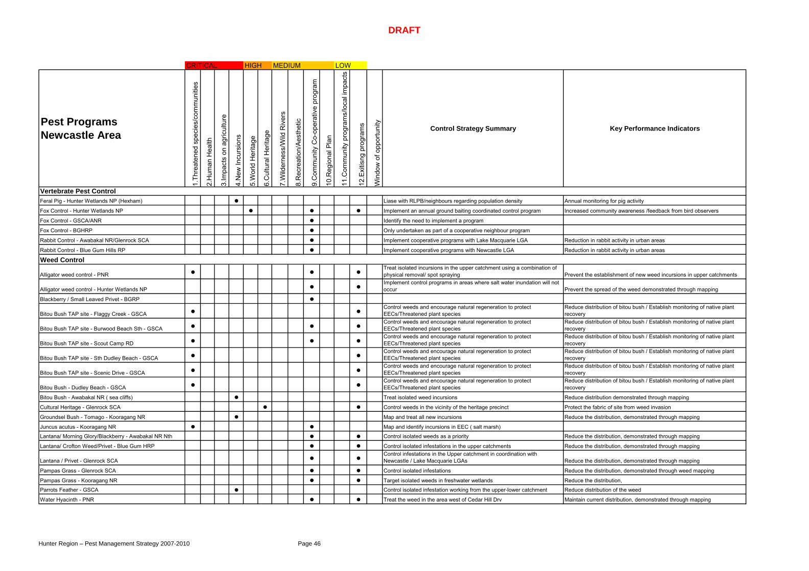
DRAFT
Hunter Region – Pest Management Strategy 2007-2010 Page 46
CRITICAL HIGH MEDIUM LOW
Pest Programs Newcastle Area
1.Th
reat
ened
spe
cies
/com
mun
ities
2.H
uman
Hea
lth
3.Im
pact
s on
agr
icul
ture
4.N
ew In
curs
ions
5.W
orld
Her
itage
6.C
ultu
ral H
erita
ge
7.W
ilder
ness
/Wild
Riv
ers
8.R
ecre
atio
n/A
esth
etic
9.C
omm
unity
Co-
oper
ativ
e pr
ogra
m
10.R
egio
nal P
lan
11.C
omm
unity
pro
gram
s/lo
cal i
mpa
cts
12.E
xitis
ng p
rogr
ams
Win
dow
of o
ppor
tuni
ty
Control Strategy Summary Key Performance Indicators
Vertebrate Pest ControlFeral Pig - Hunter Wetlands NP (Hexham) ● Liase with RLPB/neighbours regarding population density Annual monitoring for pig activity
Fox Control - Hunter Wetlands NP ● ● ● Implement an annual ground baiting coordinated control program Increased community awareness /feedback from bird observers
Fox Control - GSCA/ANR ● Identify the need to implement a program
Fox Control - BGHRP ● Only undertaken as part of a cooperative neighbour program
Rabbit Control - Awabakal NR/Glenrock SCA ● Implement cooperative programs with Lake Macquarie LGA Reduction in rabbit activity in urban areas
Rabbit Control - Blue Gum Hills RP ● Implement cooperative programs with Newcastle LGA Reduction in rabbit activity in urban areas
Weed Control
Alligator weed control - PNR ● ● ● Treat isolated incursions in the upper catchment using a combination of physical removal/ spot spraying Prevent the establishment of new weed incursions in upper catchments
Alligator weed control - Hunter Wetlands NP ● ● Implement control programs in areas where salt water inundation will not occur Prevent the spread of the weed demonstrated through mapping
Blackberry / Small Leaved Privet - BGRP ●
Bitou Bush TAP site - Flaggy Creek - GSCA ● ● Control weeds and encourage natural regeneration to protect EECs/Threatened plant species
Reduce distribution of bitou bush / Establish monitoring of native plant recovery
Bitou Bush TAP site - Burwood Beach Sth - GSCA ● ● ● Control weeds and encourage natural regeneration to protect EECs/Threatened plant species
Reduce distribution of bitou bush / Establish monitoring of native plant recovery
Bitou Bush TAP site - Scout Camp RD ● ● ● Control weeds and encourage natural regeneration to protect EECs/Threatened plant species
Reduce distribution of bitou bush / Establish monitoring of native plant recovery
Bitou Bush TAP site - Sth Dudley Beach - GSCA ● ● Control weeds and encourage natural regeneration to protect EECs/Threatened plant species
Reduce distribution of bitou bush / Establish monitoring of native plant recovery
Bitou Bush TAP site - Scenic Drive - GSCA ● ● Control weeds and encourage natural regeneration to protect EECs/Threatened plant species
Reduce distribution of bitou bush / Establish monitoring of native plant recovery
Bitou Bush - Dudley Beach - GSCA ● ● Control weeds and encourage natural regeneration to protect EECs/Threatened plant species
Reduce distribution of bitou bush / Establish monitoring of native plant recovery
Bitou Bush - Awabakal NR ( sea cliffs) ● Treat isolated weed incursions Reduce distribution demonstrated through mapping
Cultural Heritage - Glenrock SCA ● ● Control weeds in the vicinity of the heritage precinct Protect the fabric of site from weed invasion
Groundsel Bush - Tomago - Kooragang NR ● Map and treat all new incursions Reduce the distribution, demonstrated through mapping
Juncus acutus - Kooragang NR ● ● Map and identify incursions in EEC ( salt marsh)
Lantana/ Morning Glory/Blackberry - Awabakal NR Nth ● ● Control isolated weeds as a priority Reduce the distribution, demonstrated through mapping
Lantana/ Crofton Weed/Privet - Blue Gum HRP ● ● Control isolated infestations in the upper catchments Reduce the distribution, demonstrated through mapping
Lantana / Privet - Glenrock SCA ● ● Control infestations in the Upper catchment in coordination with Newcastle / Lake Macquarie LGAs Reduce the distribution, demonstrated through mapping
Pampas Grass - Glenrock SCA ● ● Control isolated infestations Reduce the distribution, demonstrated through weed mapping
Pampas Grass - Kooragang NR ● ● Target isolated weeds in freshwater wetlands Reduce the distribution,
Parrots Feather - GSCA ● Control isolated infestation working from the upper-lower catchment Reduce distribution of the weed
Water Hyacinth - PNR ● ● Treat the weed in the area west of Cedar Hill Drv Maintain current distribution, demonstrated through mapping

DRAFT
Hunter Region – Pest Management Strategy 2007-2010 Page 47
CRITICAL HIGH MEDIUM LOW
Pest Programs Great Lakes Area
1.Th
reat
ened
spe
cies
/com
mun
ities
2.H
uman
Hea
lth
3.Im
pact
s on
agr
icul
ture
4.N
ew In
curs
ions
5.W
orld
Her
itage
6.C
ultu
ral H
erita
ge
7.W
ilder
ness
/Wild
Riv
ers
8.R
ecre
atio
n/A
esth
etic
9.C
omm
unity
Co-
oper
ativ
e pr
ogra
m
10.R
egio
nal P
lan
11.C
omm
unity
pro
gram
s/lo
cal i
mpa
cts
12.E
xitis
ng p
rogr
ams
Win
dow
of o
ppor
tuni
ty
Control Strategy Summary Key Performance Indicators
Vertebrate Pest Control
Deer - WNP ● Develop a coordinated approach to deer management with landowners Reduction in Deer Density
Feral Pig - MLNP ● Monitor pig activity in the eastern side of MLNP
Fox Control - BBNP ● Monitor fox populations implement program as required Increased community awareness
Fox Control - WNP ● Monitor fox populations implement cooperative program as required Increased community awareness
Horse Management - Nerong ● Implement horse removal program as part of approved Strategy Reduction in horse populations /movement onto roadways
Wild dog - MLNP ● Reduce populations through coordinated wild dog program ( ground baiting/aerial baiting) Minimise predation through RLPB stock loss reports
Wild dog - WNP ● Reduce populations through coordinated wild dog program ( ground baiting/aerial baiting) Minimise predation through RLPB stock loss reports
Wild dog - GDNR ● Reduce populations through coordinated wild dog program ( ground baiting/aerial baiting) Minimise predation through RLPB stock loss reports
Weed Control
Climbing Asparagus - Korsmans ● ● Control isolated infestationReduce distribution, demonstrated through mapping / record any new incursions
Crofton Weed - WNP ● ● ● Control isolated infestation in upper catchment - Whoota lookoutReduce distribution, demonstrated through mapping / record any new incursions
Blackberry Control - MLNP - Corrigans Lane ● ● ● Reduce density of current infestation
Bitou TAP site - Yaccaaba ● ● ● Control weeds and encourage natural regeneration to protect EECs/Threatened plant species
Reduce distribution of bitou bush / Establish monitoring of native plant recovery
Bitou TAP site - Banksia Green - MLNP ● ● ● Control weeds and encourage natural regeneration to protect EECs/Threatened plant species
Reduce distribution of bitou bush / Establish monitoring of native plant recovery
Bitou TAP site - Mungo - Big Gibber - MLNP ● ● ● Control weeds and encourage natural regeneration to protect EECs/Threatened plant species
Reduce distribution of bitou bush / Establish monitoring of native plant recovery
Bitou TAP site - Seal Rocks - MLNP ● ● Control weeds and encourage natural regeneration to protect EECs/Threatened plant species
Reduce distribution of bitou bush / Establish monitoring of native plant recovery
Bitou TAP site - Treachery/Lighthouse - MLNP ● ● Control weeds and encourage natural regeneration to protect EECs/Threatened plant species
Reduce distribution of bitou bush / Establish monitoring of native plant recovery
Bitou TAP site - Yagon - MLNP ● ● Control weeds and encourage natural regeneration to protect EECs/Threatened plant species
Reduce distribution of bitou bush / Establish monitoring of native plant recovery
Bitou TAP site - Janie's Corner - BBNP ● ● Control weeds and encourage natural regeneration to protect EECs/Threatened plant species
Reduce distribution of bitou bush / Establish monitoring of native plant recovery
Bitou TAP site - Elizabeth/Shelly Beach - BBNP ● ● Control weeds and encourage natural regeneration to protect EECs/Threatened plant species
Reduce distribution of bitou bush / Establish monitoring of native plant recovery
Bitou TAP site - The Ruins Rainforest - BBNP ● ● Control weeds and encourage natural regeneration to protect EECs/Threatened plant species
Reduce distribution of bitou bush / Establish monitoring of native plant recovery
Bitou TAP site - Hindunes - DNR ● ● Control weeds and encourage natural regeneration to protect EECs/Threatened plant species
Reduce distribution of bitou bush / Establish monitoring of native plant recovery
Bitou Control - Beach access - MLNP ● ● Control weeds to maintain accessReduce distribution, demonstrated through mapping / record any new incursions

DRAFT
Hunter Region – Pest Management Strategy 2007-2010 Page 48
CRITICAL HIGH MEDIUM LOW
Pest Programs Great Lakes Area
1.Th
reat
ened
spe
cies
/com
mun
ities
2.H
uman
Hea
lth
3.Im
pact
s on
agr
icul
ture
4.N
ew In
curs
ions
5.W
orld
Her
itage
6.C
ultu
ral H
erita
ge
7.W
ilder
ness
/Wild
Riv
ers
8.R
ecre
atio
n/A
esth
etic
9.C
omm
unity
Co-
oper
ativ
e pr
ogra
m
10.R
egio
nal P
lan
11.C
omm
unity
pro
gram
s/lo
cal i
mpa
cts
12.E
xitis
ng p
rogr
ams
Win
dow
of o
ppor
tuni
ty
Control Strategy Summary Key Performance Indicators
Bitou Control - Boolambayte Foreshore - MLNP ● Control weeds to reduce the distribution of Bitou Bush around the Myall Lakes foreshore
Bitou Control - Beach Access/Roadsides - BBNP ● ● Control weeds to maintain accessReduce distribution, demonstrated through mapping / record any new incursions
Giant Parramatta Grass - MLNP ● Treat isolated infestations in the upper catchment Reduction in distribution demonstrated through mapping
Lantana - MLNP - Eastern camping areas ● ● Treat isolated infestations in the upper catchment Reduction in distribution demonstrated through mapping
Lantana - MLNP - Nerannie ● ● ● Treat isolated infestations in the upper catchment Reduction in distribution demonstrated through mapping
Lantana - MLNP - Nth Western ● ● Treat isolated infestations in the upper catchment Reduction in distribution demonstrated through mapping
Lantana - MLNP - Sth Western ● ● Treat isolated infestations in the upper catchment Reduction in distribution demonstrated through mapping
Lantana - GDNR ● ● Treat isolated infestations in the upper catchment Reduction in distribution demonstrated through mapping
Lantana - MNR ● ● Treat isolated infestations in the upper catchment Reduction in distribution demonstrated through mapping
Lantana - WNP ● ● Treat isolated infestations in the upper catchment Reduction in distribution demonstrated through mapping
Noogoora Burr - Nerong - MLNP ● ● Treat isolated infestation Reduction in distribution demonstrated through mapping
Mother of Millions - Seal Rocks Lighthouse ● Assess the need to implement control
Pine Plantation ● ● ● Map and develop priorities for control Reduction in distribution demonstrated through mapping
Rainforest Rehabilitation - Cape Hawke ● ● Implement bush regeneration program to protect threatened species Reduce the distribution of weeds demonstrated through mapping
Rainforest Rehabilitation - Lobster Pot Beach ● ● Implement bush regeneration program to protect threatened species Reduce the distribution of weeds demonstrated through mapping
Rainforest Rehabilitation - Mungo Brush ● ● Implement bush regeneration program to protect threatened species Reduce the distribution of weeds demonstrated through mapping
Rainforest Rehabilitation - Tamboy ● ● Implement bush regeneration program to protect threatened species Reduce the distribution of weeds demonstrated through mapping
Rainforest Rehabilitation - Seal Rocks ● ● Implement bush regeneration program to protect threatened species Reduce the distribution of weeds demonstrated through mapping
Whiskey Grass - road sides - MLNP ●

DRAFT
Hunter Region – Pest Management Strategy 2007-2010 Page 49
CRITICAL HIGH MEDIUM LOW
Pest Programs Barrington Tops Area
1.Th
reat
ened
spe
cies
/com
mun
ities
2.H
uman
Hea
lth
3.Im
pact
s on
agr
icul
ture
4.N
ew In
curs
ions
5.W
orld
Her
itage
6.C
ultu
ral H
erita
ge
7.W
ilder
ness
/Wild
Riv
ers
8.R
ecre
atio
n/A
esth
etic
9.C
omm
unity
Co-
oper
ativ
e pr
ogra
m
10.R
egio
nal P
lan
11.C
omm
unity
pro
gram
s/lo
cal i
mpa
cts
12.E
xitis
ng p
rogr
ams
Win
dow
of o
ppor
tuni
ty
Control Strategy Summary Key Performance Indicators
Vertebrate Pest ControlCats - BTNP ● Maintain access to new technologies
Feral Pig - BTNP ● ● ● ● Reduce populations of feral pig using annual ground trapping /aerial shooting
Reduced activity in sub-alpine area /monitored through Scotch Broom monitoring program
Feral Pig - CNP ● ● Reduce populations of feral pig using annual ground trapping /aerial shooting Reduce the movement of pigs onto neighbouring lands
Fox Control - BT Plateau ● ● ● Reduce population of fox through the implementation of biannual baiting programs Monitoring of Broad-toothed Rat population as an indicator species
Fox Control - CNP ● ● Reduce populations of fox through implementation of ground baiting programs Monitoring as part of the Fox TAP
Goat Control - CNP ● ● Reduce populations in areas identified as important habitat for Brush-tailed Rock Wallabies Monitor goat activity in key habitat areas
Horse Management - BTNP - plateau ● ● ● Reduce populations of feral horse on the Barrington plateau Reduction in visual damage around EEC wetlands / reduction in dung
Horse Management - CNP - Tuggalo ●Rabbit Control - BTNP - plateau ● ● Monitor populations Visual monitoring as part of fox /Btrat programs
Rabbit Control - CNP ● ● Monitor populations
Wild dog - WNP ● ● ● Reduce populations through coordinated wild dog program ( ground baiting/aerial baiting) Minimise predation through RLPB stock loss reports
Wild dog - BTNP ● ● ● Reduce populations through coordinated wild dog program ( ground baiting/aerial baiting) Minimise predation through RLPB stock loss reports
Wild dog - CTSCA ● ● Reduce populations through coordinated wild dog program Minimise predation through RLPB stock loss reports
Weed ControlBamboo - Gloucester River ● Treat as part camp ground management Removal of infestation
Blackberry Containment - BTNP ● ● Identify and treat isolated infestations as a priority Reduction in the distribution of blackberries
Blackberry Containment - CNP ● ● Treat infestation in the upper catchment as a priority Reduction in distribution demonstrated through mapping
Climbing Asparagus - CNP ● ● Identify and treated isolated infestations Reduce distribution /prevent reestablishment of new infestations
Crofton Weed/Mistflower - Gloucester Tops ● ● ● Treat infestation in the upper catchment as a priority Reduction in distribution demonstrated through mapping
Crofton Weed/Mistflower - Williams/Jerusalem ● ● ● Treat infestation in the upper catchment as a priority Reduction in distribution demonstrated through mapping
Crofton Weed/Mistflower - CNP ● ● Treat infestation in the upper catchment as a priority Reduction in distribution demonstrated through mapping
Crofton Weed/Mistflower - Mt Allan / Burraga ● ● Map current known infestations
Crofton Weed/Mistflower/Lantana - WNR ● ● Treat weeds to protect threatened plant species Reduction in distribution demonstrated through mapping
Giant Parramatta Grass - TGNR ● ● Map and Control isolated infestations in coordination with LGA Reduction in distribution
Lantana - RCNR ● ● Treat isolated infestations in the upper catchment Reduction in distribution demonstrated through mapping
Lantana - BNR ● ● Treat isolated infestations in the upper catchment Reduction in distribution demonstrated through mapping
Lantana - TGNR ● Treat isolated infestations in the upper catchment Reduction in distribution demonstrated through mapping

DRAFT
Hunter Region – Pest Management Strategy 2007-2010 Page 50
CRITICAL HIGH MEDIUM LOW
Pest Programs Barrington Tops Area
1.Th
reat
ened
spe
cies
/com
mun
ities
2.H
uman
Hea
lth
3.Im
pact
s on
agr
icul
ture
4.N
ew In
curs
ions
5.W
orld
Her
itage
6.C
ultu
ral H
erita
ge
7.W
ilder
ness
/Wild
Riv
ers
8.R
ecre
atio
n/A
esth
etic
9.C
omm
unity
Co-
oper
ativ
e pr
ogra
m
10.R
egio
nal P
lan
11.C
omm
unity
pro
gram
s/lo
cal i
mpa
cts
12.E
xitis
ng p
rogr
ams
Win
dow
of o
ppor
tuni
ty
Control Strategy Summary Key Performance Indicators
Lantana - CNP ● Treat isolated infestations in the upper catchment Reduction in distribution demonstrated through mapping
Lantana - MNR ● ● Treat isolated infestations in the upper catchment Reduction in distribution demonstrated through mapping
Lantana - CTSCA ● ● Treat isolated infestations in the upper catchment Reduction in distribution demonstrated through mapping
Leucantheum - BTNP ● Monitor/remove new weed incursions Reduce the distribution of this weed
Madeira Vine/Potato Vine - CTSCA ● Treat isolated infestations in the upper catchment/prevent new incursions Reduce the distribution of this weed
Pepper Tree /Large Leaved Privet/Tree of Heaven- CNP ● Treat form the upper catchment/liase with neighbours in upper catchment/target areas where threatened species occur Reduce the distribution of this weed
Rainforest Rehabilitation - WNP ● Implement bush regeneration program to protect threatened species Reduce the distribution of weeds demonstrated through mapping
Roadside weeds - CNP ● ● Monitor and treat weeds following road works
St Johns Wort - CNP ● Map and treat entire infestation Prevent seed set/ reduce the distribution of the weed
Scotch Broom Containment ● ● ● ● ● Implement the Scotch Broom Containment strategy 10 year mapping of distribution/abundance /annual transect monitoring
Sweet Briar/ Cotoneaster/Hawthorn - CNP ● Treat isolated infestations working from the upper catchment Reduce the distribution demonstrated through weed mapping
Yorkshire Fog - BTNP ● ● Identify / Implement control priorities Prevent infestation in unaffected catchments - Edwards Swamp complex

DRAFT
Hunter Region – Pest Management Strategy 2007-2010 Page 51
CRITICAL HIGH MEDIUM LOW Other
Pest Programs Upper Hunter Area
1.Th
reat
ened
spe
cies
/com
mun
ities
2.H
uman
Hea
lth
3.Im
pact
s on
agr
icul
ture
4.N
ew In
curs
ions
5.W
orld
Her
itage
6.C
ultu
ral H
erita
ge
7.W
ilder
ness
/Wild
Riv
ers
8.R
ecre
atio
n/A
esth
etic
9.C
omm
unity
Co-
oper
ativ
e pr
ogra
m
10.R
egio
nal P
lan
11.C
omm
unity
pro
gram
s/lo
cal i
mpa
cts
12.E
xitis
ng p
rogr
ams
Win
dow
of o
ppor
tuni
ty
Control Strategy Summary Key Performance Indicators
Vertebrate Pest ControlAerial Shooting Program - WNR, BHGNP, TNP ● ● ● Biannual program to reduce populations Support ground based programs by reducing populations
Cats - Poleblue/Btops Plateau ● Implement strategic cage trapping programs
Deer - Murrurundi/ Crawney Pass ● ● ● Monitor populations through biannual aerial surveys Compare population changes
Feral Pig - BTSCA ● ● ● ● Reduce populations of feral pig using annual ground trapping /aerial shooting
Reduced activity in sub-alpine area /monitored through Scotch Broom monitoring program
Feral Pig - BHG ● ● Reduce populations of feral pig using annual ground trapping /aerial shooting
Feral Pig - TNP ● ● Reduce populations of feral pig using annual ground trapping /aerial shooting
Fox Control - BT Plateau ● ● Reduce population of fox through the implementation of biannual baiting programs Monitoring of Broad-toothed Rat population as an indicator species
Fox Control - TNP ● ● ● Reduce populations of fox prior to lambing season Reduced activity on neighbouring lands
Fox Control - CGNR ● ● Reduce fox population through annual baiting Reduced activity on neighbouring lands
Goat Control - TNP ● ● ● Reduce goat populations in EEC /threatened species Reduced populations in EECs/threatened species
Horse Management - BTNP - plateau ● ● ● Reduce populations of feral horse on the Barrington platea Reduction in visual damage around EEC wetlands / reduction in dung
Rabbit Control - BTNP - plateau ● ● Monitor populations Visual monitoring as part of fox /Btrat programs
Rabbit Control - BMNR ● ● ● Reduce populations Visual monitoring
Wild dog - BTSCA/NP ● ● ● ● ● Reduce populations through coordinated wild dog program ( ground baiting/aerial baiting) Minimise predation through RLPB stock loss reports
Wild dog - BHGNP ● ● ● ● Reduce populations through coordinated wild dog program ( ground baiting/aerial baiting) Minimise predation through RLPB stock loss reports
Wild dog - TNR ● ● ● ● Reduce populations through coordinated wild dog program ( ground baiting/aerial baiting) Minimise predation through RLPB stock loss reports
Wild dog - BRNR ● ● ● ● Reduce populations through coordinated wild dog program ( ground baiting/aerial baiting) Minimise predation through RLPB stock loss reports
Wild dog - WNR ● ● ● Reduce populations through coordinated wild dog program ( ground baiting/aerial baiting) Minimise predation through RLPB stock loss reports
Wild dog - Woolooma (aerial baiting) ● ● ● Reduce populations through coordinated wild dog program ( ground baiting/aerial baiting) Minimise predation through RLPB stock loss reports
Wild Dog - Crawney Pass (aerial baiting) ● ● ● Reduce populations through coordinated wild dog program ( ground baiting/aerial baiting) Minimise predation through RLPB stock loss reports
Wild dog - Murrurundi ( aerial baiting) ● ● Reduce populations through coordinated wild dog program ( ground baiting/aerial baiting) Minimise predation through RLPB stock loss reports
Weed ControlBlackberry Containment - BTNP ● ● Treat isolated infestations as a priority Reduction in the distribution of blackberries
Blackberry Control - TNP ● ● Control blackberries in the upper catchment Reduction in the upper catchment
Blackberry/ St Johns Wort - Murrundi Pass ● ● ●

DRAFT
Hunter Region – Pest Management Strategy 2007-2010 Page 52
CRITICAL HIGH MEDIUM LOW Other
Pest Programs Upper Hunter Area
1.Th
reat
ened
spe
cies
/com
mun
ities
2.H
uman
Hea
lth
3.Im
pact
s on
agr
icul
ture
4.N
ew In
curs
ions
5.W
orld
Her
itage
6.C
ultu
ral H
erita
ge
7.W
ilder
ness
/Wild
Riv
ers
8.R
ecre
atio
n/Ae
sthe
tic
9.C
omm
unity
Co-
oper
ativ
e pr
ogra
m
10.R
egio
nal P
lan
11.C
omm
unity
pro
gram
s/lo
cal i
mpa
cts
12.E
xitis
ng p
rogr
ams
Win
dow
of o
ppor
tuni
ty
Control Strategy Summary Key Performance Indicators
Bridal Creeper - Scone Mountain Grassy Box Woodland
Lantana - Towarri NP ● Eradicate isolated infestation
Leucantheum - BTSCA ● Monitor/remove new weed incursions Reduce the distribution of this weed
Pear sp.- CGNR ● Encourage biocontrol activity Annual identification of biocontrol activity
Privet , Bridal Creeper - TNP ● Implement control programs targeting upper catchment Reduction in the upper catchment
Tiger Pear - BMNR ● Treat all pear in the vicinity of recreational access A reduction in pear in recreation areas
Scotch Broom Containment - BTNP/BTSCA ● ● Implement the Scotch Broom Containment strategy 10 year mapping of distribution/abundance /annual transect monitoring
Thistles Control - BHGNP ● Maintain machinery/vehicles does not spread thistle seed in
Tree of Heaven - TNP ● ● Annual monitoring of treated area Prevent reestablishment
Tree of Heaven - BTNP ● Annual monitoring of treated area Prevent reestablishment
Yorkshire Fog - BTNP /BTSCA ● ● Identify / Implement control priorities
Xanthium - Towarri ● Implement cooperative program with neighbours Impact on neighbours domestic stock

DRAFT
Hunter Region – Pest Management Strategy 2007-2010 Page 53
Appendix 2 – Declared Weeds
Common name (Botanic name) Dungo
gGlo
uces
ter
Great
Lak
esLi
verp
ool P
lains
Maitlan
dNew
cast
lePo
rt St
ephe
nsTa
mwor
thUpp
er H
unte
r
African boxthorn (Lycium ferocissimum ) 4 4 4 4 4 4 4 4 4African feather grass (Pennisetum macrourum ) 5 5 5 5 5 5 5 5 5African turnipweed (Sisymbrium runcinatum ) 5 5 5 5 5 5 5 5 5African turnipweed (Sisymbrium thellungii) 5 5 5 5 5 5 5 5 5Alligator weed (Alternanthera philoxeroides ) 2 2 2 2 3 3 3 2 2Anchored water hyacinth (Eichhornia azuerea ) 1 1 1 1 1 1 1 1 1Annual ragweed (Ambrosia artemisiifolia ) 5 5 5 5 5 5 5 5 5Arrowhead (Sagittaria montevidensis ) 5 5 5 5 5 5 5 5 5Artichoke thistle (Cynara cardunculus ) 5 5 5 5 5 5 5 5 5Athel tree (Tamarix aphylla ) 5 5 5 5 5 5 5 5 5Bathurst burr (Xanthium spp.) 4 4 4 4 4 4 4 4 4Bear-skin fescue (Festuca gautieri ) 5 5 5 5 5 5 5 5 5Black knapweed (Centaurea nigra ) 1 1 1 1 1 1 1 1Blackberry (Rubus spp.) 4 4 4 4 4 4 4 4Blue heliotrope (Heliotropium amplexicaule )Bitou bush (Chrysanthemoides monilifera ) 4 4 4Bridal creeper (Asparagus asparagoides) 5 5 5 5 4 5 5 5 5Broad-leaf pepper tree (Schinus terebinthifolius ) 3 3Broomrapes (Orobanche sp.) 1 1 1 1 1 1 1 1 1Burr ragweed (Ambrosia confertiflora ) 5 5 5 5 5 5 5 5Cabomba (Cabomba caroliniana ) 5 5 5 5 5 5 5 5 5Cape tulips (Homeria spp.) 4 4 4 4 4Cayenne snakeweed (Stachytarpheta cayennensis ) 5 5 5 5 5 5 5 5Chilean needle grass (Nassella neesiana ) 4 4 4 4 4 4 4 4 4Chinese celtis (Celtis sinensis ) 3 3Chinese violet (Asystasia gangetica ssp. micrantha ) 1 1 1 1 1 1 1 1 1Clockweed (Gaura lindheimeri ) 5 5 5 5 5 5 5 5 5Clockweed (Gaura parviflora ) 5 5 5 5 5 5 5 5 5Columbus grass (Sorghum almum ) 4 4 4 4 4 4 4 4Corn sowthistle (Sonchus arvensis ) 5 5 5 5 5 5 5 5 5Crofton weed (Ageratina adenophora ) 4 4 4 4 4Dodder (Cuscuta spp.) 5 5 5 5 5 5 5 5 5Espartillo (Achnatherum brachychaetum ) 5 5 5 5 5 5 5 5East Indian hygrophila (Hygrophila polysperma ) 1 1 1 1 1 1 1 1 1Eurasian water milfoil (Myriophyllum spicatum ) 1 1 1 1 1 1 1 1 1Fine-bristled burr grass (Cenchrus biflorus ) 5 5 5 5 5 5 5 5 5Fountain grass (Pennisetum setaceum ) 5 5 5 5 5 5 5 5Gallon’s curse (Cenchrus biflorus ) 5 5 5 5 5 5 5 5 5Galvanised burr (Sclerolaena birchii ) 4 4 4Giant reed / elephant grass (Arundo donax ) 4Giant Parramatta grass (Sporobolus fertilis ) 3 3 4 3 3 3 3 3 3Giant rattail grass (Sporobolus pyramidalis ) 3 3Glaucous starthistle (Carthamus glaucus ) 5 5 5 5 5 5 5 5Golden dodder (Cuscuta campestris ) 4 4 4 4 4 4 4 4 4Golden thistle (Scolymus hispanicus ) 5 5 5 5 5 5 5 5Green cestrum (Cestrum parqui ) 3 3 3 3 3 3 3 3 3Groundsel bush (Baccharis halimifolia ) 3 3 3 3 3 3Harrisia cactus (Harrisia sp.) 4 4 4 4 4 4 4 4 4Hawkeweeds (Hieracium spp.) 1 1 1 1 1 1 1 1 1Hemlock (Conium maculatum ) 4Horsetail (Equisetum spp.) 1 1 1 1 1 1 1 1 1Hygrophila (Hygrophila costata ) 2 2 2 2Hymenachne (Hymenachne amplexicaulis ) 1 1 1 1 1 1 1 1 1Johnsons grass (Sorghum halepense ) 4 4 4 4 4 4 4 4 4Karoo thorn (Acacia karroo ) 1 1 1 1 1 1 1 1Kochia (Kochia scoparia ) 1 1 1 1 1 1 1 1 1Lagarosiphon (Lagarosiphon major ) 1 1 1 1 1 1 1 1 1Lantana (Lantana spp.) 5 4,5 4,5 5 5 5 5 5

DRAFT
Hunter Region – Pest Management Strategy 2007-2010 Page 54
Common name (Botanic name) Dung
ogGlo
uces
ter
Great
Lak
esLi
verp
ool P
lains
Maitlan
dNew
cast
lePo
rt St
ephe
nsTa
mwor
thUpp
er H
unte
r
Leafy elodea (Egeria densa ) 5 5 5 5 5 5 5 5Lippia (Phyla spp.) 4Long-leaf willow primrose (Ludwigia longifolia ) 5 5 4,5 5 4,5 4,5 4,5 5 5Mexican feather grass (Nassella tenuissima ) 1 1 1 4 1 1 1 1 1Mexican poppy (Argemone mexicana ) 5 5 5 5 5 5 5 5 5Miconia (Miconia spp.) 1 1 1 1 1 1 1 1 1Mimosa (Mimosa pigra ) 1 1 1 1 1 1 1 1 1Mistflower (Ageratina riparia ) 4 4 4 4Mintweed (Salvia reflexa ) 4 4Mossman river grass (Cenchrus echinatus ) 5 5 5 5 5 5 5 5Mother-of-millions (Bryophyllum delagoense ) 3 3 3 4 3 4 4 4 3Nodding thistle (Carduus nutans ) 4 4 4 5 4 4Onion grass (Romulea spp.) 5 5 5 5 5 5 5 5 5Oxalis (Oxalis spp. and varieties) 5 5 5 5 5 5 5 5 5Parthenium weed (Parthenium hysterophorus ) 1 1 1 1 4 1 1 1 1Parkinsonia (Parkinsonia aculeata ) 2Pampas grass (Cortaderia selloana ) 4 4 4 4 4 4 4 4 4Patersons curse (Echium spp.) 4 4 4 4 4 4 4 4 4Prickly acacia (Acacia nilotica ) 1 1 1 1 1 1 1 1 1Prickly pear (Cylindropuntia spp.) 1 4 4 4 4 4 4 4 4Prickly Pear (Opuntia spp.) 4 4 4 4 4 4 4 4 4Privet – broad-leaf (Ligustrum lucidum ) 4Privet – narrow-leaf (Ligustrum sinense ) 4Pond apple (Annona glabra ) 1 1 1 1 1 1 1 1 1Red rice (Oryza rufipogon ) 5 5 5 5 5 5 5 5Rhus tree (Toxicodendron succedaneum ) 4 4 4 4 4 4 4 4 4Rubbervine (Cryptostegia grandiflora ) 1 1 1 1 1 1 1 1 1Rhizomatous bamboo (Phyllostachys spp.) 4Sagittaria (Sagittaria platyphylla ) 5 5 5 5 5 5 5 5Salvinia (Salvinia molesta ) 3 3 2 3 3 3 2 2Sand oat (Avena strigosa ) 5 5 5 5 5 5 5 5Scotch broom (Cytisus scoparius ) 4 4 4 4 4Senegal tea plant (Gymnocoronis spilanthoides ) 1 1 1 1 1 1 1 1 1Serrated tussock (Nassella trichotoma ) 4 4 4 3 4 4 4 3 3Soldier thistle (Picnomon acarna ) 5 5 5 5 5Siam weed (Chromolaena odorata ) 1 1 1 1 1 1 1 1 1Silk forage sorghum (Sorghum sp. hybrid cultivar) 4 4Silver leaf nightshade (Solanum elaeagnifolium ) 3 3 4Smooth-stemmed turnip (Brassica barrelieri ssp. oxyrrhina )
5 5 5 5 5 5 5
Spiny burrgrass (Cenchrus incertus ) 4 4 4 4 4 4 4 4 4Spiny burrgrass (Cenchrus longispinus ) 4 4 4 4 4 4 4 4 4Spiny emex (Emex australis ) 4 4 4 4Spotted knapweed (Centaurea maculosa ) 1 1 1 1 1 1 1 1 1St Johns wort (Hypericum perforatum ) 3 3 3 4 4 4 4 4 4Star thistle (Centaurea calcitrapa ) 4 4 4Texas blueweed (Helianthus ciliaris ) 5 4 5 5 5 5 5 5Sweet briar (Rosa rubiginosa ) 4 4Tree of heaven (Ailanthus altissima ) 4Water caltrop (Trapa spp.) 1 1 1 1 1 1 1 1 1Water hyacinth (Eichhornia crassipes ) 4 3 3 2 4 4 4 2 2Water lettuce (Pistia stratiotes ) 1 1 1 1 1 1 1 1 1Water soldier (Stratiotes aloides ) 1 1 1 1 1 1 1Willows (Salix spp. except S. babylonica , S. reichardtii , S. calodendron )
5 5 5 5 5 5 5 5 5
Witchweed (Striga spp.) 1 1 1 1 1 1 1 1 1Yellow burrhead (Limnocharis flava ) 1 1 1 1 1 1 1 5 1Yellow nutgrass (Cyperus esculentus ) 5 5 5 5 5 5 5 5
Control Class 1 – State Prohibited Weeds Control Class 2 – Regionally Prohibited weeds Control Class 3 – Regionally Controlled Weeds Control Class 4 – Locally Controlled Weeds
Control Class 5 – Restricted Plants Control Classes 1, 2 and 5 noxious weeds are referred to as notifiable weeds.