petroleum geology and authors geochemistry of …...petroleum geology and geochemistry of the...
TRANSCRIPT
AUTHORS
Christopher D. Laughrey � PennsylvaniaDepartment of Conservation and NaturalResources, Topographic and Geologic Survey,Subsurface Geology Section, 400 WaterfrontDrive, Pittsburgh, Pennsylvania 15222-4740;[email protected]
Christopher D. Laughrey is a senior geologicscientist with the Pennsylvania GeologicalSurvey where he has worked since 1980. Healso teaches a graduate course in sandstonepetrology for the Department of Geology andPlanetary Sciences at the University of Pitts-burgh. Laughrey worked as a geophysicalanalyst for the Western Geophysical Companyin Houston, Texas, before taking his presentposition in Pittsburgh, Pennsylvania. His specialinterests include isotope and organic geo-chemistry, sedimentary petrology, boreholegeophysics, and geographic information sys-tem applications in the earth sciences.
Dan A. Billman � Billman GeologicConsultants, P. O. Box 567, 402 LincolnAvenue, Mars, Pennsylvania 16046
Dan A. Billman received his B.S. degree fromthe University of Toledo in 1986 and his M.S.degree from West Virginia University in 1989.Dan worked for Mark Resources Corporationand Eastern States Exploration Company priorto forming Billman Geologic Consultants, Inc.,where he is president and principal geologist.Dan’s current interests include geologic andeconomic evaluation of development and ex-ploratory projects, especially in the Appala-chian basin.
Michael R. Canich � Equitable Production,Allegheny Center Building, South Commons,Suite 414, Pittsburgh, Pennsylvania 15212
Michael R. Canich has worked 26 years in theoil and gas industry, beginning with two yearsdeveloping exploration prospects in the Gulf ofMexico. The last 24 years have been spent in theAppalachian basin exploring and developingnatural gas in Silurian and Devonian aged tightgas sand reservoirs. He is currently the directorof Reserve Development for Equitable Produc-tion Company in Pittsburgh, Pennsylvania.
Petroleum geology andgeochemistry of the CouncilRun gas field, northcentral PennsylvaniaChristopher D. Laughrey, Dan A. Billman,and Michael R. Canich
ABSTRACT
The Council Run field of north central Pennsylvania is one of the
most productive natural gas fields in the central Appalachian basin.
The field is enigmatic because of its position near the eastern edge
of the Appalachian Plateau, where strata with reservoir potential
elsewhere have low porosities and permeabilities or are poorly
sealed. Council Run has four principal reservoir sandstones. The
lower three occur in a distinct fourth-order type 1 stratigraphic
sequence. The stacking pattern of sandstones in this sequence de-
fines lowstand, transgressive, and highstand systems tracts.
Core, well-log, and map interpretations reveal that the lowest
interval consists of multiple coarsening-upward parasequences de-
posited in deltaic and nearshore environments of the lowstand sys-
tems tract during a forced regression. Most of these sandstones are
lithic, and some are highly feldspathic. Productive sandstones dis-
play hybrid void textures that consist of reduced primary inter-
granular pores preserved, in part, by relatively early petroleum em-
placement and secondary oversized fabric-selective pores.
The generative potential of the organic matter in the potential
source rocks is exhausted, but geochemical and petrographic evi-
dences indicate that these black shales originally contained oil-prone
kerogens and generated liquid hydrocarbons. Stable isotope geo-
chemistry suggests that gases were generated by primary cracking of
kerogens and/or by secondary cracking of oil between 320 and 290
Ma. Dispersive migration paths were both lateral and vertical be-
cause of compression associated with Alleghanian orogenesis. Most
of the oil in the Devonian section was cracked to gas during deeper
burial between 270 and 240 Ma.
AAPG Bulletin, v. 88, no. 2 (February 2004), pp. 213–239 213
Copyright #2004. The American Association of Petroleum Geologists. All rights reserved.
Manuscript received January 4, 2001; provisional acceptance September 5, 2001; revised manuscriptreceived February 22, 2002; final acceptance October 6, 2003.

INTRODUCTION
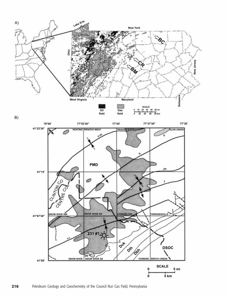
Council Run field is the easternmost significant natural gas field in
Pennsylvania (Figure 1). It is also one of the most prolific fields in
the entire Appalachian basin (Donaldson et al., 1996). Eastern States
Exploration Company (a former Statoil subsidiary now owned by
Equitable Resources) discovered Council Run field in 1982. To
date, about 700 wells, with an average spacing of 40 ac (0.16 km2),
have been drilled in the Upper Devonian sandstone reservoirs of the
field. It is now developed across a 751-km2 (290-mi2) area in Centre
and Clinton Counties in north central Pennsylvania (Figure 1).
Cumulative production through December 2001 is 56.4 bcf. Es-
timated ultimate recoverable (EUR) reserves per well range from
less than 100 mmcf to more than 1.0 bcf; the average EUR in the
field is approximately 200 mmcf of gas. Ryder (1995) estimates the
ultimate recovery in Council Run field as about 250 bcf of gas.
The Council Run field is located near the eastern edge of the
Appalachian Plateau, a gently folded upland northwest of the more
intensely deformed central Appalachian Ridge and Valley. The
field is developed adjacent to the Allegheny structural front, which
separates the Appalachian Plateau from the ridge and valley. Pro-
duction at Council Run is from Upper Devonian sandstones. Minor
oil and gas production from Upper Devonian rocks in the eastern
plateau has occurred sporadically since at least 1903, and deeper
reservoirs in Ordovician, Silurian, and Lower Devonian rocks of the
region were discovered in the late 1970s and early 1980s (Harper
et al., 1982; Laughrey and Harper, 1996). Nevertheless, before
Council Run’s discovery, petroleum exploration and development
of Paleozoic rocks in Pennsylvania, especially Upper Devonian sand-
stones, was largely constrained to its western and central regions.
Reasons for avoiding exploration in the eastern plateau included
high drilling and finding costs (Cornell, 1971) and the supposed
probability of poor seals because of structural complexity in rocks
close to the structural front (Bayer, 1982). More importantly, po-
tential source rocks are postmature in the eastern Appalachian Pla-
teau, and very low porosities and permeabilities were anticipated in
possible reservoir rocks because of advanced diagenesis associated
with high burial temperatures in the geologic past (Harris, 1979;
Streib, 1981; Beaumont et al., 1987).
In 1982, Eastern States Exploration Company drilled the No. 1
Commonwealth of Pennsylvania Tract 231 well on a state forest-
lands lease. The well was completed in an 11-m (36-ft)-thick sand-
stone (the ‘‘Fifth Elk’’ sandstone) at a depth of 1413–1424 m
(4636–4672 ft) in the Upper Devonian Lock Haven Formation
(Figure 2). The after-fracture open flow was 1.96 mmcf gas/day,
and the reported reservoir pressure was 1740 psi (1.20 � 107 Pa)
after 7 days. This discovery well established the Council Run field.
Porosities in the pay zone, calculated from the neutron and density
logs, ranged from 6.9 to 16%, and calculated gas saturations were
as high as 83.2%. The gas was relatively dry (C1/P
Cn = 0.97), but
analyses of the stable carbon and hydrogen isotopes of the methane
ACKNOWLEDGEMENTS
We thank Equitable Resources and StatoilEnergy, Inc., for permission to use freely theirgeological and geophysical data in the prepa-ration of this report. We especially thank BruceJankura, Statoil’s former senior vice presidentof Production and Operations at Council Run,for his help with collecting data and arranginggas sampling. We thank Dennis Coleman, Iso-tech, for his assistance in obtaining stable iso-tope data for the gases produced at Council Runand adjacent fields. Donald Hoskins, SamuelBerkheiser, John Harper, Kathy Flaherty, andThomas Flaherty all read earlier drafts of thisreport, and we appreciate their reviews andconstructive comments. We also appreciate thebeneficial reviews by R. C. Milici, M. H. Feeley,and T. L Dunn, which helped us improve themanuscript. Released by permission of thedirector, Pennsylvania Bureau of Topographicand Geologic Survey.
214 Petroleum Geology and Geochemistry of the Council Run Gas Field, Pennsylvania
(d13CH4 = �50xand dDCH4= �210x) revealed that
it was an oil-associated gas originally generated, with
liquid hydrocarbons in the early oil window (Laughrey
and Baldassare, 1998). These data suggested that gas
emplacement occurred relatively early in the burial his-
tory of the Upper Devonian rocks and that the integrity
of the traps and seals remained intact throughout the
complex tectonic history of the reservoirs.
Natural gas is produced at Council Run from var-
ious stacked, lenticular sandstones in the Upper Devo-
nian Catskill and Lock Haven formations (Figures 2, 3).
Entrapment is stratigraphic. Producing sandstones oc-
cur at depths ranging from 762 to 1524 m (2500 to
5000 ft). The Third Bradford, basal Bradford, and var-
ious Elk sandstones, particularly the Fifth Elk, are the
most prolific reservoir rocks in the field; these par-
ticular sandstones are in the Lock Haven Formation.
The reservoir rocks at Council Run comprise a variety
of marine and nonmarine facies (Rahmanian, 1979;
Slingerland and Loule, 1988; Warne and McGhee,
1991; Cotter and Driese, 1998; Castle, 2000). Selected
aspects of the petroleum geology of some of these res-
ervoirs were discussed by Billman et al. (1991), Kel-
leher and Johnson (1991), Bruner and Smosna (1994),
Humphrey et al. 1994, Donaldson et al. (1996), and
Smosna and Bruner (1997).
Eastern State’s success at Council Run initiated a
surge of exploration in Upper Devonian rocks along and
near the structural front (Harper and Cozart, 1982).
Gas production like that at Council Run field, however,
has yet to be duplicated elsewhere in the eastern pla-
teaus of the central Appalachian basin.
The purpose of this paper is to describe the stra-
tigraphy of the major producing sandstones in the
Council Run field, interpret the reservoir geology of
the principal producing sandstone, the Fifth Elk sand-
stone, and to document the petroleum geochemistry
of the source rocks and produced natural gases at the
field. We demonstrate the utility of sequence stratig-
raphy for understanding the distribution of important
reservoir rocks at Council Run. We propose a burial
history and petroleum migration model that is ap-
plicable to exploring for other Upper Devonian gas
accumulations near the Allegheny Front in the central
Appalachian basin.
STRATIGRAPHIC FRAMEWORK
Faill et al. (1977) defined the Lock Haven Formation
as the gray, brown, and green interbedded shales,
siltstones, and sandstones that overlie the Brallier For-
mation and underlie the red beds of the Catskill For-
mation (Figure 2). The Lock Haven Formation also
contains a few thin-bedded quartz pebble conglomer-
ates. The Lock Haven Formation is recognized through-
out central and north-central Pennsylvania (Faill et al.,
1977; Faill et al., 1989; Taylor, 1997). It is 600–1180 m
(1970–3876 ft) thick where exposed (Faill et al., 1977).
Lock Haven strata crop out along the Allegheny Front
just 3.2 km (2 mi) southeast of the Council Run field.
Warne and McGhee (1991) informally subdivided
the Lock Haven Formation along its outcrop at the Al-
legheny Front into a lower shaly member and an upper
sandy member (Figure 3). They correlated the transi-
tion between these two members with a late Frasnian
eustatic sea level fall. This drop in sea level is one of
two (the second occurs at the base of the Third Brad-
ford sandstone in Figure 3) that occurred in a distinct
Late Devonian third-order transgressive-regressive (T-R)
cycle. Johnson et al. (1985) designated this particular
cycle as cycle IId (Figure 3). T-R cycle IId comprises a
pair of transgressions and two short-lived but pro-
nounced regressions (Warne and McGhee, 1991).
These two Late Devonian regressions identified in
the outcrop of the upper sandy member of the Lock
Haven Formation resulted in unconformable surfaces
that we interpret as sequence boundaries. The lower
sequence boundary occurs at the base of the upper sandy
member of the Lock Haven Formation and is marked
by a basinward shift of facies (Figure 3). The lower
shaly member of the Lock Haven Formation contains
fine-grained turbidites interpreted to have been depos-
ited on a low-angle, slope apron environment (Warne
and McGhee, 1991, p. 103–104). The upper sandy
member sandstones are very fine to fine grained, cal-
citic, hematitic, and fossiliferous. They exhibit abun-
dant evidence of shallow-water deposition, including
wave ripple marks, flaser lamination and bedding, and
hummocky cross-stratification (Warne and McGhee,
1991). The upper sequence boundary occurs at the top
of cycle IId (Figure 3). This boundary corresponds to
the pronounced sea level drop that occurred in the
latest Frasnian and it, too, marks a basinward shift in
facies. Widespread fluvial and paralic sandstones over-
lie rocks deposited in a sublittoral shelf depositional
environment during a eustatic sea level highstand (Den-
nison, 1985; Warne and McGhee, 1991). Both uncon-
formities are type 1 sequence boundaries, and they
bound a fourth-order type 1 sequence (Van Wagoner
et al., 1988, 1990). The lowstand, transgressive, and
highstand systems tracts of this sequence can be
Laughrey et al. 215
216 Petroleum Geology and Geochemistry of the Council Run Gas Field, Pennsylvania
recognized by the stacking patterns of the sandstones
exposed along the Allegheny Front in central Pennsyl-
vania (Figure 3).
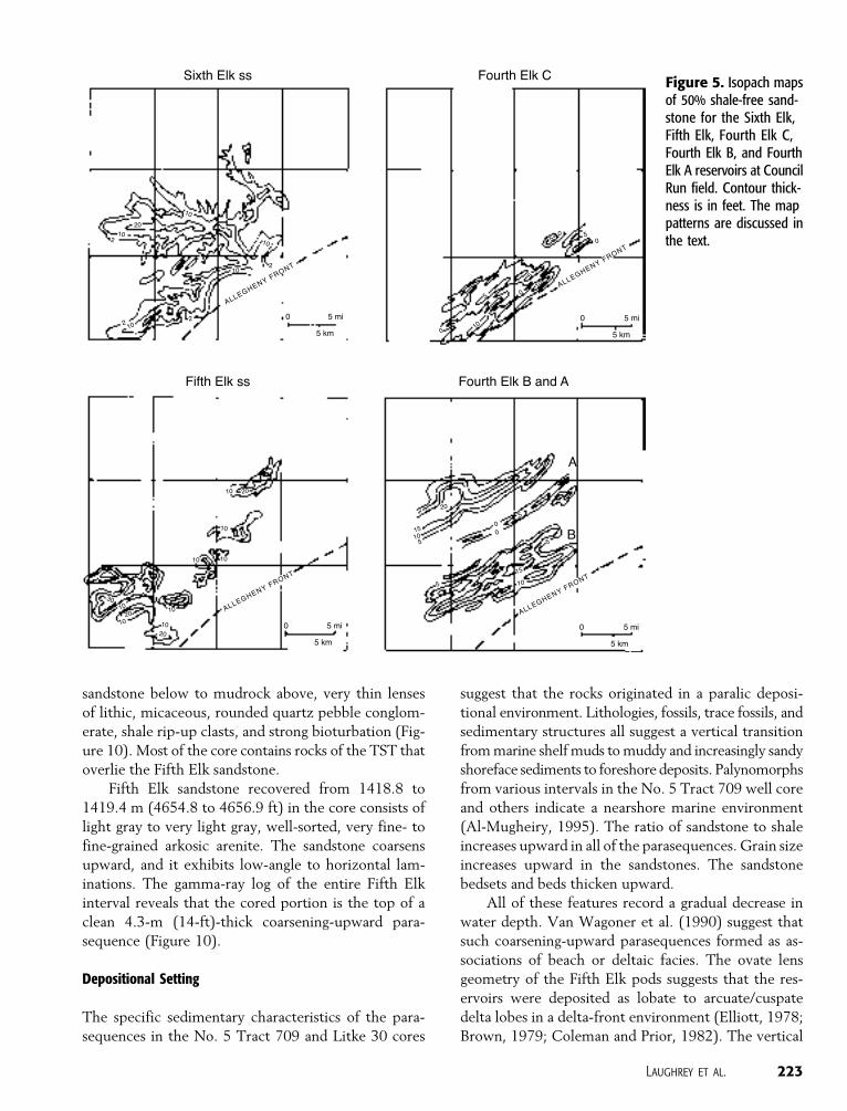
This fourth-order sequence in the upper part of
Devonian cycle IId can also be recognized in the sub-
surface at Council Run field (Figure 4). There, Lock
Haven strata below the Fifth Elk sandstone consist of
marine mudrocks and fine-grained, argillaceous sand-
stones that were deposited in relatively deep water. The
Sixth Elk sandstone, for example, occurs approximate-
ly 3–6 m (10–20 ft) below the base of the Fifth Elk
sandstone. An isopach map of 50% shale-free Sixth Elk
sandstone (Figure 5) reveals an elongate radial geom-
etry. Core samples of these rocks consist of argillaceous,
micaceous siltstone and very fine-grained lithic wackes.
Detrital grains are angular. Matrix consists of illite and
sericite. We interpret the Sixth Elk interval as slope
deposits correlative to the turbidite deposits in the lower
shaly member of the Lock Haven Formation described
by Warne and McGhee (1991). This is consistent with
our interpretation of the base of the Fifth Elk sand-
stone as an unconformity and sequence boundary.
The interpreted lower sequence boundary at the
base of the Fifth Elk sandstone is marked by a basinward
shift in facies and a vertical change in parasequence
stacking pattern (Figure 4). The Fifth Elk sandstone is
interpreted as a lowstand clastic wedge deposited dur-
ing a forced regression (Al-Mugheiry, 1995 and this
study). The Fifth Elk sandstone consists of isolated pods
of relatively coarse-grained deltaic shoreface and fore-
shore deposits encased in fine-grained marine shales
(Figures 5, 6). The Fifth Elk interval offlaps the sub-
jacent marine mudrocks. A distinct marine flooding
surface (described in detail below) separates the Fifth
Elk sandstone from the overlying transgressive systems
tract (TST).
We can correlate the Fifth Elk sandstone in the
Council Run field with the sandstone that crops out
at the base of the upper sandy member of the Lock
Haven Formation on the basis of position in the stra-
tigraphic section and palynology. Both the Fifth Elk
sandstone in the gas field and the sandstone at the base
of the upper sandy member at the Milesburg outcrop
occur approximately 396 m (1300 ft) above the top of
the Brallier Formation. Palynomorphs collected from
core samples of the Fifth Elk sandstone at Council Run
by Al-Mugheiry (1995, p. 27–30) all come from the
Archeoperisaccus ovali–Verrucosisporites buliferus assem-
blage zone, which correlates with the middle Polygnathusassymetricus–Palmatolepis gigas conodont zone. The mid-
dle P. gigas zone includes the sequence defined by the
base of the Fifth Elk sandstone and the base of the Third
Bradford sandstone.
The Fourth Elk C sandstones above the Fifth Elk
interval occur in the lower portion of the TST. These
reservoir sandstones consist of paralic, fining-upward
parasequences exhibiting coastal onlap (Figures 5, 6).
Marine siltstones and shales are the principal litholo-
gies in the TST, reflecting the predominance of shelf
sediments and processes. Core samples reveal that thin
fossiliferous limestone beds also occur in the TST. This
fourth-order tract also contains two fifth-order retro-
gradational sandstones that produce gas in the north-
west portion of the Council Run field (Fourth Elk B
and A in Figures 5, 6).
The basal Bradford sandstone is the principal res-
ervoir in the highstand systems tract (Figure 4). It con-
sists of a relatively thick, progradational coarsening-
upward parasequence.
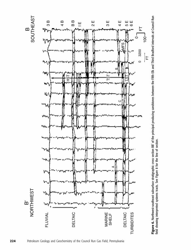
The tripartite vertical succession of predominantly
coarse-fine-coarse lithologies observed in the respective
lowstand, transgressive, and highstand systems tracts of
this sequence is a characteristic signature for incised-
valley-fill sediments (Cotter and Driese, 1998 and
references therein). Note in Figure 7 how the thin
sandstones of the Fourth Elk interval stack laterally
along strike to the southwest. These sandstones dip
northeast and are centered on remnant channel and
Figure 1. (A) Oil and gas fields map of Pennsylvania showing the location of Council Run field (CR). Brace Creek (BC) and BlackMoshannon (BM) are two other fields discussed in the text. (B) Council Run field outline (shaded area), U.S. Geological Survey 7.5-min quadrangles, bedrock geology, and principal structural features of the study area. PMD = Pennsylvanian, Mississippian, andDevonian bedrock; Dck = Catskill Formation; Dlh = Lock Haven Formation; Dbh = Brallier and Harrell Formations; DSOC = Devonian,Silurian, Ordovician, and Cambrian bedrock; s-s = Snow Shoe syncline; f = Ferney anticline; jm = Jersey Mills syncline; h = Hyneranticline; c-m = Clearfield-McIntyre syncline. Dashed lines represent strike-slip faults. The Allegheny Front, a major topographicescarpment, follows the trend of the Catskill Formation (Dck) in the Council Run field area. Surface rocks exposed along the structuralfront dip gently northwestward into the Snow Shoe syncline. Two deep gas fields adjacent to the Council Run field, the Devils Elbowfield (DE ), and the Grugan field (G) produce from anticlinal traps in Lower Silurian and Upper Ordovician rocks, respectively. The231 1 well is the discovery well in the field.
Laughrey et al. 217

delta-front facies in the Fifth Elk sandstone (discussed
in detail below). These same sandstones onlap shore-
ward to the southeast (Figure 6). This geometry may
reflect incised-valley filling during marine transgression.
The top of the sequence occurs at the base of the
Third Bradford sandstone (Figure 4). The Third Brad-
ford interval comprises a complex fluvial system de-
veloped from northeast to southwest between the
Hyner anticline and the Allegheny Front (Humphrey
et al., 1994). Production is predominantly from point-
bar facies in this fluvial system. The Third Bradford
sandstone is part of the lowstand systems tract de-
veloped at the base of another fourth-order sequence
in the upper Lock Haven Formation.
Figure 2. Stratigraphiccolumn for the CouncilRun field vicinity.
218 Petroleum Geology and Geochemistry of the Council Run Gas Field, Pennsylvania
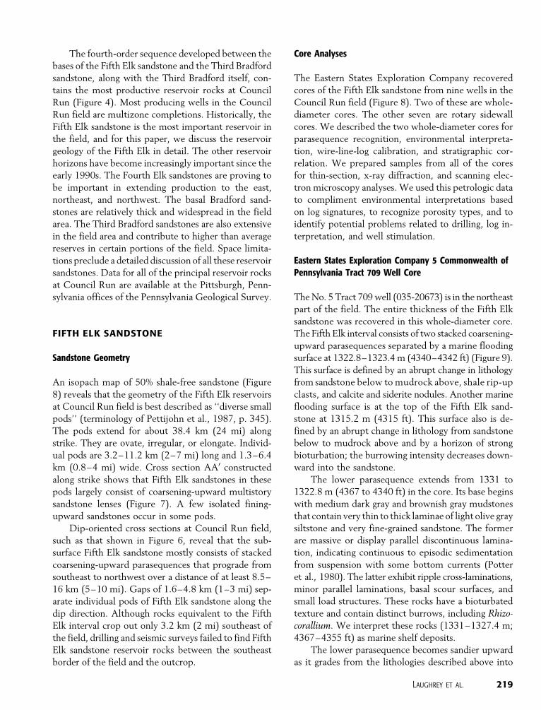
The fourth-order sequence developed between the
bases of the Fifth Elk sandstone and the Third Bradford
sandstone, along with the Third Bradford itself, con-
tains the most productive reservoir rocks at Council
Run (Figure 4). Most producing wells in the Council
Run field are multizone completions. Historically, the
Fifth Elk sandstone is the most important reservoir in
the field, and for this paper, we discuss the reservoir
geology of the Fifth Elk in detail. The other reservoir
horizons have become increasingly important since the
early 1990s. The Fourth Elk sandstones are proving to
be important in extending production to the east,
northeast, and northwest. The basal Bradford sand-
stones are relatively thick and widespread in the field
area. The Third Bradford sandstones are also extensive
in the field area and contribute to higher than average
reserves in certain portions of the field. Space limita-
tions preclude a detailed discussion of all these reservoir
sandstones. Data for all of the principal reservoir rocks
at Council Run are available at the Pittsburgh, Penn-
sylvania offices of the Pennsylvania Geological Survey.
FIFTH ELK SANDSTONE
Sandstone Geometry
An isopach map of 50% shale-free sandstone (Figure
8) reveals that the geometry of the Fifth Elk reservoirs
at Council Run field is best described as ‘‘diverse small
pods’’ (terminology of Pettijohn et al., 1987, p. 345).
The pods extend for about 38.4 km (24 mi) along
strike. They are ovate, irregular, or elongate. Individ-
ual pods are 3.2–11.2 km (2–7 mi) long and 1.3–6.4
km (0.8–4 mi) wide. Cross section AA0 constructed
along strike shows that Fifth Elk sandstones in these
pods largely consist of coarsening-upward multistory
sandstone lenses (Figure 7). A few isolated fining-
upward sandstones occur in some pods.
Dip-oriented cross sections at Council Run field,
such as that shown in Figure 6, reveal that the sub-
surface Fifth Elk sandstone mostly consists of stacked
coarsening-upward parasequences that prograde from
southeast to northwest over a distance of at least 8.5–
16 km (5–10 mi). Gaps of 1.6–4.8 km (1–3 mi) sep-
arate individual pods of Fifth Elk sandstone along the
dip direction. Although rocks equivalent to the Fifth
Elk interval crop out only 3.2 km (2 mi) southeast of
the field, drilling and seismic surveys failed to find Fifth
Elk sandstone reservoir rocks between the southeast
border of the field and the outcrop.
Core Analyses
The Eastern States Exploration Company recovered
cores of the Fifth Elk sandstone from nine wells in the
Council Run field (Figure 8). Two of these are whole-
diameter cores. The other seven are rotary sidewall
cores. We described the two whole-diameter cores for
parasequence recognition, environmental interpreta-
tion, wire-line-log calibration, and stratigraphic cor-
relation. We prepared samples from all of the cores
for thin-section, x-ray diffraction, and scanning elec-
tron microscopy analyses. We used this petrologic data
to compliment environmental interpretations based
on log signatures, to recognize porosity types, and to
identify potential problems related to drilling, log in-
terpretation, and well stimulation.
Eastern States Exploration Company 5 Commonwealth ofPennsylvania Tract 709 Well Core
The No. 5 Tract 709 well (035-20673) is in the northeast
part of the field. The entire thickness of the Fifth Elk
sandstone was recovered in this whole-diameter core.
The Fifth Elk interval consists of two stacked coarsening-
upward parasequences separated by a marine flooding
surface at 1322.8–1323.4 m (4340–4342 ft) (Figure 9).
This surface is defined by an abrupt change in lithology
from sandstone below to mudrock above, shale rip-up
clasts, and calcite and siderite nodules. Another marine
flooding surface is at the top of the Fifth Elk sand-
stone at 1315.2 m (4315 ft). This surface also is de-
fined by an abrupt change in lithology from sandstone
below to mudrock above and by a horizon of strong
bioturbation; the burrowing intensity decreases down-
ward into the sandstone.
The lower parasequence extends from 1331 to
1322.8 m (4367 to 4340 ft) in the core. Its base begins
with medium dark gray and brownish gray mudstones
that contain very thin to thick laminae of light olive gray
siltstone and very fine-grained sandstone. The former
are massive or display parallel discontinuous lamina-
tion, indicating continuous to episodic sedimentation
from suspension with some bottom currents (Potter
et al., 1980). The latter exhibit ripple cross-laminations,
minor parallel laminations, basal scour surfaces, and
small load structures. These rocks have a bioturbated
texture and contain distinct burrows, including Rhizo-corallium. We interpret these rocks (1331–1327.4 m;
4367–4355 ft) as marine shelf deposits.
The lower parasequence becomes sandier upward
as it grades from the lithologies described above into
Laughrey et al. 219

220 Petroleum Geology and Geochemistry of the Council Run Gas Field, Pennsylvania
interbedded mudstones and sandstones. The latter are
thin- to medium-bedded, light olive gray, very fine-
grained rocks. They are bioturbated, but do contain
some parallel and ripple cross-laminations, slump struc-
tures, and convolute bedding. This mixed heterolithic
association of mudstone and lenticular to wavy bedded
sandstone shows a repeated alternation between phys-
ical and biological sedimentary processes related to
storm and fair-weather periods (Elliott, 1978). We
interpret this interval from 1327.4 to 1324.7 m (4355
to 4346 ft) as muddy lower shoreface deposits.
The upper portion of this first parasequence, from
1323.7 m to its top at 1322.8 m (4343 to 4340 ft),
consists of medium gray to light greenish gray, very
fine-grained sublitharenite. The sandstone displays bur-
rows and low-angle planar cross-laminations near its
base, but sedimentary structures become obscure up-
ward. Much of the sandstone is mottled because of
intercalated organic matter. Shale rip-up clasts occur at
1323 and 1323.4 m (4341 and 4342 ft). Small calcite
nodules are scattered throughout the sandstone be-
tween 1323 and 1323.4 m (4341 and 4342 ft). A large
siderite nodule crosses the core at 1323 m (4340.4 ft).
The siderite and calcite indicate moderate reducing
conditions; the organic matter intercalated in the sand-
stones probably contributed to reducing conditions in
the original sediment (Pettijohn et al., 1987). We in-
terpret this upper portion of the parasequence as upper
shoreface to foreshore sandstones capped by a trans-
gressive lag that marks the marine flooding surface at
1322.8–1323.4 m (Figure 9).
The upper parasequence in the No. 5 Tract 709
well core contains a similar vertical facies distribu-
tion. It extends from 1322.8 to 1315.2 m (4340 to
4315 ft). The parasequence begins with interbedded
mudstone and sandstone (1322.8–1321.6 m; 4340–
4336 ft), which we interpret as marine shelf deposits
above the marine flooding surface. The mudstones of
this interval are medium dark gray and bioturbated.
They contain abundant small horizontal burrows filled
with sand and clay. Pyrite is common in these bur-
rows. The sandstones of this interval are very light
gray to medium dark gray, very fine grained, and largely
bioturbated. Sedimentary structures include ripples, low-
angle cross-lamination, wavy bedding, convolute bed-
ding, scour surfaces, and small load structures.
Interpreted lower shoreface deposits occur from
1321.6 to 1318 m (4336 to 4324 ft). Light to medium
dark gray, very fine-grained sandstones dominate this
interval, although it also contains thin interbeds of
dark gray mudrock. The sandstones are sublitharenites
and subarkoses. They mostly occur in medium-sized,
bioturbated, wavy or lenticular beds, although a few of
the sandstones contain low-angle parallel laminations.
The core contains brachiopods between 1320 and
1320.7 m (4331 and 4333 ft).
The upper part of this parasequence, from 1318 to
1315 m (4324 to 4315 ft), consists of very light gray, very
fine- and fine-grained sublitharenites and subarkoses.
Sedimentary structures include trough and planar cross-
bedding, parallel lamination, ripple cross-laminations,
minor wavy and lenticular bedding, and some scour
surfaces. Shale rip-up clasts are concentrated at the
base of the trough cross-beds, and a few are scattered
throughout the interval. A few brachiopods and bur-
rows also occur in this section. We interpret this upper-
most interval as upper shoreface and foreshore de-
posits based on published depositional models of
Elliott (1978), Reinson (1979), and Reineck and Singh
(1980).
Litke 30 Well Core
The Litke 30 well (027-20283) is in the center of the
field. Coring operations in this well recovered sand-
stone and shale samples from the Fourth Elk interval
and sandstone from the uppermost Fifth Elk interval
(Figure 10). Only the top 0.64 m (2.1 ft) of the Fifth
Elk sandstone were recovered in the core, but it is sig-
nificant because the samples from directly above the
sandstone reveal evidence of the same marine flooding
surface identified at the top of the reservoir in the No. 5
Tract 709 core. This marine flooding surface in the
Litke core is at 1418.3–1418.8 m (4653.1–4654.8 ft).
It is defined by an abrupt change in lithology from
Figure 3. Correlation of the Lock Haven Formation outcrop with the subsurface Lock Haven rocks encountered in the Council Runfield. The outcrop and well are 3.2 km (2 mi) apart. Percent sandstone in the outcrop section and terminology are from Warne andMcGhee (1991). The Frasnian and Famennian cycles are from Johnson et al. (1985). LST = lowstand systems tract. TST =transgressive systems tract. HST = highstand systems tract. The gamma-ray log shows driller’s names for specific reservoir sandstonesin the Catskill and Lock Haven formations at Council Run field.
Laughrey et al. 221

Figure 4. Gamma-ray log of the Texas Gulf A22well in Council Run field showing the interpretedtype I sequence preserved between the baseof the Fifth Elk and Bradford Third reservoirsandstones.
222 Petroleum Geology and Geochemistry of the Council Run Gas Field, Pennsylvania
sandstone below to mudrock above, very thin lenses
of lithic, micaceous, rounded quartz pebble conglom-
erate, shale rip-up clasts, and strong bioturbation (Fig-
ure 10). Most of the core contains rocks of the TST that
overlie the Fifth Elk sandstone.
Fifth Elk sandstone recovered from 1418.8 to
1419.4 m (4654.8 to 4656.9 ft) in the core consists of
light gray to very light gray, well-sorted, very fine- to
fine-grained arkosic arenite. The sandstone coarsens
upward, and it exhibits low-angle to horizontal lam-
inations. The gamma-ray log of the entire Fifth Elk
interval reveals that the cored portion is the top of a
clean 4.3-m (14-ft)-thick coarsening-upward para-
sequence (Figure 10).
Depositional Setting
The specific sedimentary characteristics of the para-
sequences in the No. 5 Tract 709 and Litke 30 cores
suggest that the rocks originated in a paralic deposi-
tional environment. Lithologies, fossils, trace fossils, and
sedimentary structures all suggest a vertical transition
from marine shelf muds to muddy and increasingly sandy
shoreface sediments to foreshore deposits. Palynomorphs
from various intervals in the No. 5 Tract 709 well core
and others indicate a nearshore marine environment
(Al-Mugheiry, 1995). The ratio of sandstone to shale
increases upward in all of the parasequences. Grain size
increases upward in the sandstones. The sandstone
bedsets and beds thicken upward.
All of these features record a gradual decrease in
water depth. Van Wagoner et al. (1990) suggest that
such coarsening-upward parasequences formed as as-
sociations of beach or deltaic facies. The ovate lens
geometry of the Fifth Elk pods suggests that the res-
ervoirs were deposited as lobate to arcuate/cuspate
delta lobes in a delta-front environment (Elliott, 1978;
Brown, 1979; Coleman and Prior, 1982). The vertical
Figure 5. Isopach mapsof 50% shale-free sand-stone for the Sixth Elk,Fifth Elk, Fourth Elk C,Fourth Elk B, and FourthElk A reservoirs at CouncilRun field. Contour thick-ness is in feet. The mappatterns are discussed inthe text.
Laughrey et al. 223
Figu
re6
.Nor
thw
est-
sout
heas
tsu
bsur
face
stra
tigra
phic
cros
sse
ctio
nBB
0of
the
prin
cipa
lpro
duci
ngsa
ndst
ones
betw
een
the
Fifth
Elk
and
Thir
dBr
adfo
rdin
terv
als
atC
ounc
ilRu
nfie
ldsh
owin
gin
terp
rete
dsy
stem
str
acts
.Se
eFi
gure
8fo
rth
elin
eof
sect
ion.
224 Petroleum Geology and Geochemistry of the Council Run Gas Field, Pennsylvania

Figure 7. Stratigraphic cross section AA0 constructed along strike showing sandstone geometry of the Fifth Elk sandstone across theCouncil Run field. See Figure 8 for the line of section.
Figure 8. Enlargement of theisopach map of 50% shale-freeFifth Elk sandstone at CouncilRun field shown in Figure 5.Contour thickness is in feet. Thedifferent cross section lines arediscussed in the text. Well sym-bols represent locations of coredwells.
Laughrey et al. 225
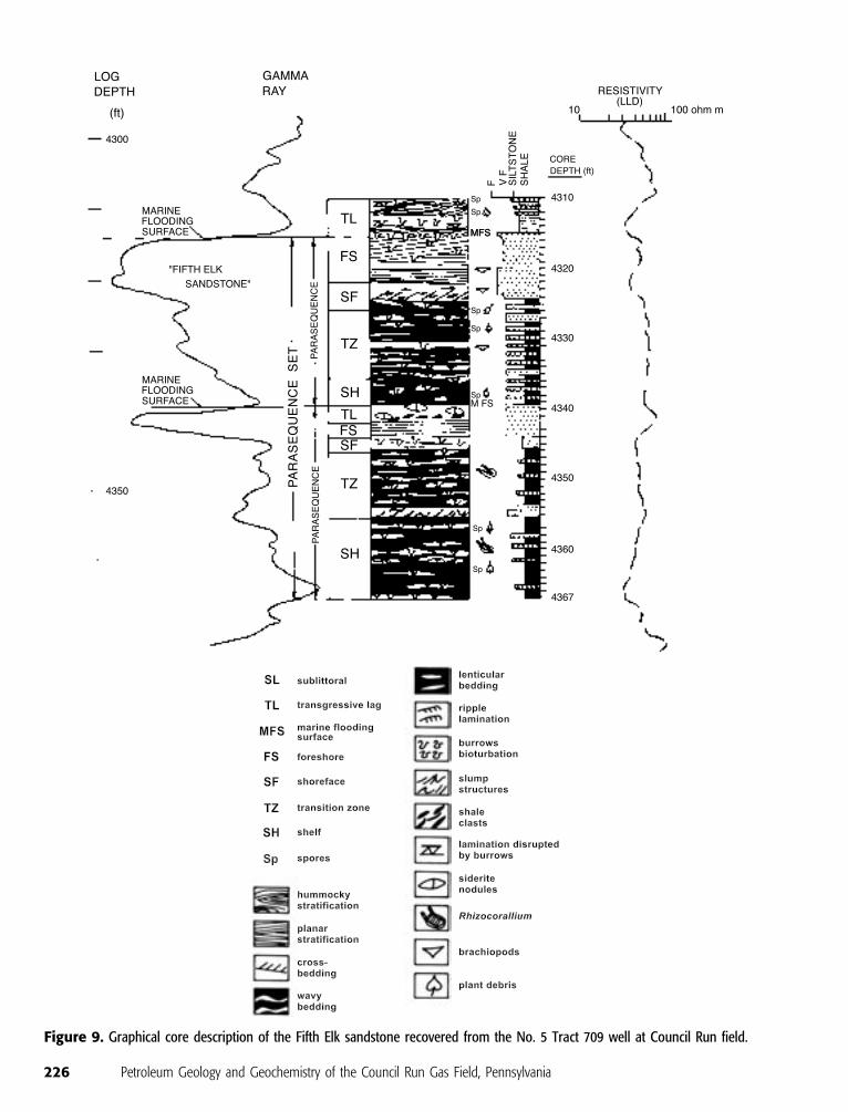
Figure 9. Graphical core description of the Fifth Elk sandstone recovered from the No. 5 Tract 709 well at Council Run field.
226 Petroleum Geology and Geochemistry of the Council Run Gas Field, Pennsylvania

facies arrangement of shelf to shoreface to foreshore
deposits interpreted in the Fifth Elk cores bears a sim-
ilarity to the vertical facies associations in the offlap
sequence of the Brazos River delta of the Texas coast
described by Bernard et al. (1970). Closely spaced
gamma-ray log cross sections through the largest lobe in
the southwest part of the Council Run field (Figure 11)
show the prevalence of coarsening-upward sandstones
throughout the reservoir body. A serrate funnel-shaped
pattern is the dominant gamma-ray log signature in the
Fifth Elk sandstone at Council Run as it is in the Brazos
River delta. Restricted blocky and fining-upward log
patterns running through portions of the east end of the
largest Fifth Elk sandstone pod might represent
remnants of the original distributary channel fill (Figure
11, lines 1 and 2).
Equivalent strata exposed along the Allegheny Front
southeast, or landward, of the Council Run field were
deposited in marine to beach environments (Warne,
1986; Warne and McGhee, 1991). There is no evidence
for coeval delta-plain facies, Fifth Elk distributary chan-
nels, or any other significant sandy facies between Coun-
cil Run and the structural front. Posamentier et al. (1992)
suggest that direct evidence of feeder systems to paralic
sandstones of lowstand systems tracts deposited during
a forced regression is commonly lacking, as is the case of
the Fifth Elk sandstone at Council Run field. This is
because the coeval alluvial plain deposits landward of
the lowstand shorelines were thin because of sedimen-
tary bypass, or they were removed because of ravine-
ment during a subsequent transgression (Posamentier
et al., 1992, p. 1705; Posamentier and Allen, 1993).
Figure 10. Graphical core description of the uppermost Fifth Elk sandstone and overlying mudrocks and sandstones of thetransgressive systems tract recovered in the Litke 30 well core. See legend in Figure 9.
Laughrey et al. 227

Petrography
We examined 42 thin sections of the Fifth Elk sand-
stone from cores recovered in the Council Run field.
All of the sandstone samples were pressure impregnated
with clear, blue-dyed epoxy, and the thin-section bil-
lets were ground past the disturbed surfaces where
grain plucking might have occurred to assure accurate
identification of secondary pore fabrics. We also tab-
ulated petrographic data generated by consultants and
service companies for Eastern States Exploration Com-
pany over the years of Council Run development.
Figure 11. Closely spaced north-south gamma-ray log cross sections of the Fifth Elk sandstone interval in the southwest portion ofthe Council Run field. See Figure 8 for the locations of the lines of section. Most logs reveal coarsening-upward sandstone (finestippling), although a few (coarse stippling, lines 1 and 2) do exhibit blocky and fining-upward patterns. The latter might bedistributary channel remnants.
228 Petroleum Geology and Geochemistry of the Council Run Gas Field, Pennsylvania
Some of the latter information was published by Bill-
man et al. (1991), Bruner and Smosna (1994), and
Smosna and Bruner (1997). The purpose of our petro-
graphic analysis was to document the nature of porosity
in the Fifth Elk sandstone and to determine the po-
tential for formation damage that could be caused by
completion and stimulation procedures.
Two-thirds of the Fifth Elk sandstone samples are
sublitharenites. The remainder consists of arkosic are-
nites, subarkoses, and lithic arenites. The sandstones
are very fine to fine grained and moderately to well
sorted. Detrital grains comprise an average 70.6% of the
bulk mineral composition of the rocks and contain an
average of 44.6% monocrystalline quartz, 4.3% poly-
crystalline quartz, and 1.0% chert. Lithic grains include
abundant metamorphic rock fragments (mean = 9.0%)
and lesser amounts of igneous and sedimentary frag-
ments. Feldspars make up between 2 and 27% of the
bulk mineralogy. The mean feldspar content of the
sandstones is 10%. Albite is the most common feldspar
in the sandstones, whereas potassium feldspars com-
prise only traces to a few percent of the total. Acces-
sories include muscovite, biotite, and various heavy
minerals, along with small quantities of recrystallized
fossils, phosphate and dolomite pellets, and dissemi-
nated organic material.
Clay minerals occur in the Fifth Elk sandstones as
matrix and authigenic cement. Clay matrix accounts
for an average of 8.5% of the bulk mineral composi-
tion of the sandstones. It occurs as pseudomatrix, lam-
inar shale, and dispersed shale. Pseudomatrix formed
through the deformation of ductile rock fragments
during compaction of the sandstones. Some of the dis-
persed shales were also deformed by compaction. Au-
thigenic clay minerals constitute 5–9% of the Fifth
Elk’s bulk mineralogy and average 6% in the sandstones.
Iron-rich chlorite is the most abundant authigenic clay.
It occurs as pore-lining and pore-filling euhedral, pseu-
dohexagonal crystals. Authigenic kaolinite occurs in
the sandstones as pore-filling stacks of pseudohexago-
nal plates or books. Minor amounts of authigenic illite
occur as thin fibrous flakes or wispy laths that coat
detrital grains and partially fill intergranular pores.
Authigenic quartz and carbonate cements make
up an average 20.4% of the bulk mineral composition
of the Fifth Elk samples. Silica cement ranges from 8 to
30% and averages 17%. It occurs as (1) syntaxial over-
growths on framework quartz grains, (2) pore-bridging
crystals, and (3) large interlocking euhedral crystals
that partially occlude intergranular pore spaces and
throats. Carbonate cements in the sandstones include
ferroan dolomite, siderite, and calcite. These carbonate
cements occur in scattered clusters of small crystals or
patches of sparry cement. Ferroan dolomite (ankerite)
occurs as rhombic or sparry pore-filling cement. Cal-
cite is present in trace amounts as isolated patches of
sparry cement. Siderite occurs as microcrystalline mo-
saics of pore-filling cement.
Minor cements present in trace quantities in the
Fifth Elk sandstones include feldspar overgrowths, py-
rite, and anhydrite.
Porosities of the Fifth Elk sandstone, measured in
thin sections, range from 1 to 14%. Porosities measured
by core and geophysical log analyses are as high as 16%.
Good porosities in the pay zones (>6%) exhibit two
principal textures: reduced primary intergranular po-
rosity and secondary oversized fabric-selective porosity
(terminology of Schmidt and McDonald, 1979). In
most instances, sandstones with the highest porosities
(10–14%) have void spaces that are combinations of
these two pore textures. Microporosity in the sand-
stones is associated with pore-lining clay cements.
Reduced primary pores account for one-fourth to
one-half of the total porosity of most of the sandstones
with 6% or more porosity. Preservation of primary po-
rosity occurred through incomplete cementation and
chlorite grain coats that inhibited the nucleation of sil-
ica cements on detrital grains. In a few samples, the
emplacement of hydrocarbons, which are now present
as bitumen, preserved original primary pores. This mech-
anism of porosity preservation in the Lock Haven
Formation sandstones was first noted by Billman et al.
(1991) and Bruner and Smosna (1994) and appears to
be regional phenomena in these rocks along the length
of the Allegheny structural front.
Secondary oversized fabric-selective porosity ac-
counts for as much as three-fourths of the total po-
rosity in Fifth Elk sandstones with more than 6%
porosity. It formed principally through the leaching of
chemically labile lithic fragments and feldspars. Most
of these pores contain clay mineral residues. The dis-
solution of carbonate cement and recrystallized fossils
also contributed to this secondary pore texture. The
largest oversized fabric-selective voids formed where
plastically deformed lithics were dissolved, leaving what
Bruner and Smosna (1994) called elongate ‘‘channel’’
pores.
The generally low porosities and permeabilities of
the Fifth Elk sandstone are typical of Upper Devonian
sandstones in the central Appalachian basin and are
the reason that hydraulic fracture stimulation is rou-
tinely required to complete wells drilled in the Council
Laughrey et al. 229
Run field. Depositional porosity and permeability of
the Fifth Elk sandstones were substantially reduced
by compaction and cementation. Secondary dissolu-
tion porosity enhances the productivity of the Fifth
Elk sandstones locally in the field. The sandstones are
devoid of expandable clay minerals and are not sus-
ceptible to damage from contact with freshwater-
based fluids. Pore-filling kaolinite and fibrous, pore-
lining illite pose a potential problem with particle
migration; formation/wellbore-pressure differentials
should be limited during well completion and pro-
duction, and the Fifth Elk should be treated with poly-
mers designed to stabilize silt- and clay-sized minerals.
The rocks contain minor amounts of acid-soluble car-
bonate. Acid solubility of the reservoir is insignificant,
and acidization will not improve reservoir performance.
The Fifth Elk sandstones contain notable amounts of
iron-bearing chlorite and small amounts of siderite and
pyrite, rendering the rocks susceptible to formation
damage from contact with HCl or oxygenated fluids.
Damage can be limited by using weak acid when re-
moving drilling mud and cement debris from perfora-
tion tunnels, by blending an iron chelating agent into
the acid, and by recovering the acid from the reservoir
as quickly as possible.
GEOCHEMISTRY OF PETROLEUM SOURCEROCKS AND NATURAL GASES AT COUNCILRUN FIELD
Petroleum Source Rocks
Potential source rocks in the study area include the
Burket Member of the Upper Devonian Harrell For-
mation, the Middle Devonian Marcellus Formation,
and the Upper Ordovician Utica Shale (Figure 2).
These are the only rocks in the region with sufficient
total organic carbon to have generated commercial quan-
tities of hydrocarbons (Figure 12). Black shales of the
Burket and Marcellus (Devonian) are the likely source
of the hydrocarbons produced from the Upper De-
vonian sandstones at Council Run field. The Utica
Shale (Ordovician) is the probable source rock for gas
produced from the deeper reservoirs at Devil’s Elbow
and Grugan fields (Donaldson et al., 1996; Laughrey
and Harper, 1996; Laughrey and Baldassare, 1998).
Source rocks in the Burket Member and Marcellus
Formation at Council Run field are postmature. Vit-
rinite reflectance (Ro) of kerogen samples from these
stratigraphic intervals ranges from 2.81 to 3.0%. The
thermal alteration index of the samples is 4.0. None of
the kerogen samples fluoresce under ultraviolet light.
Rock-Eval pyrolysis of Burket and Marcellus shales
shows that the rocks have poor petroleum potential
because of advanced thermal maturation: S1 in these
rocks ranges from 0.17 to 0.39 mg HC/g rock, and S2
is less than 0.1 mg HC/g rock; the production index
is 0.61.
The kerogens in the Burket and Marcellus shales
are 90–100% amorphous, with traces to 5% each of
vitrinite and inertinite. Amorphous kerogens are gen-
erally presumed to be hydrogen rich and oil prone
(Peters and Casa, 1994, p. 98), but the postmature
character of our samples makes it difficult to interpret
the type of organic matter on the basis of petrography.
Gas chromatograms of bitumen extracts from the
Burket and Marcellus shales display an odd-carbon
predominance of midchain normal alkanes (C15–C19)
and a relatively low abundance of higher molecular
weight compounds. Such normal alkane distributions
are typical of organic matter deposited in shaly marine
source rocks (Peters and Moldowan, 1993). The dom-
inance of smaller molecules in these samples, howev-
er, probably reflects the postmature nature of the
source rocks (Hunt, 1996, p. 134). The carbon pref-
erence index values (1.13–1.53), pristane/phytane
ratios (1.18–1.36), and isoprenoid-to-normal-alkane
ratios (pristane/n-C17 = 0.43–0.56 and phytane/n-C18 =
0.43–0.49) most likely reflect maturation effects instead
of source organic matter composition.
Several other lines of evidence do suggest that the
spent source rocks in the Burket Member and Mar-
cellus Formation originally contained oil-prone kero-
gens and generated liquid hydrocarbons in the geologic
past. First, type II organic matter occurs in the Mar-
cellus Formation black shales analyzed in less mature
sample suites west and northwest of the Allegheny
Front in Pennsylvania (Milici, 1993; Laughrey, 1997).
Second, oil produced from the Lock Haven Formation
at Brace Creek field in Bradford County, northeast of
Council Run field (Figure 1A), also originated in the
Burket Member and Marcellus Formation (Laughrey,
1997). The source rocks are also postmature at this
location. The oil produced at Brace Creek field exhibits
characteristics typical of oil that was subjected to high
thermal stress, i.e., high API gravity (45.8j), a normal
alkane maximum at C9, and no biomarkers. Near-
surface rocks at Brace Creek field are on the borderline
between oil preservation and gas-only preservation.
The oil escaped complete thermal destruction because
of extensive vertical migration and was subsequently
230 Petroleum Geology and Geochemistry of the Council Run Gas Field, Pennsylvania
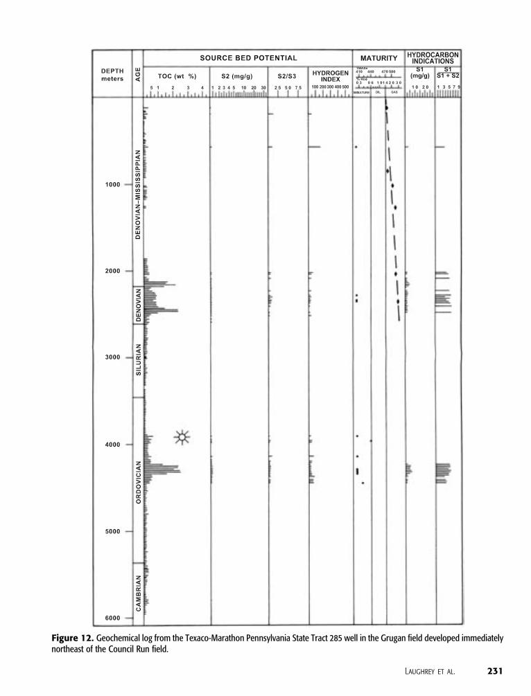
Figure 12. Geochemical log from the Texaco-Marathon Pennsylvania State Tract 285 well in the Grugan field developed immediatelynortheast of the Council Run field.
Laughrey et al. 231
preserved under relatively cooler conditions in the
reservoir. Third, Bruner and Smosna (1994) documen-
ted the presence of dead oil or bitumen in the pore
spaces of the Lock Haven reservoir sandstones at
Council Run field. Fourth, methane produced from
the Upper Devonian sandstones at Council Run field
is isotopically light relative to the postmature kero-
gens found in the probable source rocks (Laughrey
and Baldassare, 1998). Gas produced today at Council
Run field was originally associated with oil and was
generated, in part, when the source rocks were in the oil
window.
Natural Gas Geochemistry
For this study, we sampled gases from eight wells and a
compressor station to determine the chemical and
stable isotopic composition of the hydrocarbons pro-
duced from Upper Devonian reservoirs at Council Run
field as well as the adjacent gas fields that produce
from different stratigraphic intervals (Table 1). Seven
of the samples are gases from Upper Devonian Lock
Haven and Catskill Formation rocks at Council Run.
One of the samples is gas from the Black Moshannon
field located southwest of the Council Run field. This
gas is produced from very thin, relatively porous and
permeable beds in the Brallier Formation, just above
the source rocks of the Burket Member. One gas
sample is from the Lower Silurian Tuscarora Forma-
tion at Devil’s Elbow field south of Council Run.
Figure 13 shows the gas samples on a plot of
methane d13C vs. dD. The plot shows the nine samples
from Table 1 along with three additional samples from
Laughrey and Baldassare (1998); these include gases
from the Fifth Elk sandstone at Council Run, the Bral-
lier Formation at Black Moshannon field, and the Up-
per Ordovician Bald Eagle Formation at Grugan field
(Figure 2). The gases produced from Upper Devonian
sandstones at Council Run all plot in the field labeled,
‘‘thermogenic gas, with oil.’’ We interpret these meth-
ane samples as mixtures of gases generated with oil as
the source rocks passed through the oil window and
gases later cracked from oil in the reservoir rocks. The
gases produced from the Brallier Formation are more
mature, plotting in the field for methane associated
with condensate. The Silurian and Ordovician gas sam-
ples are distinctly postmature and plot near the upper
limits of the condensate-associated gas field, near its
border with the dry thermogenic gas field.
In addition to methane d13C and dD, we measured
d13C for ethane and propane in most of our samples
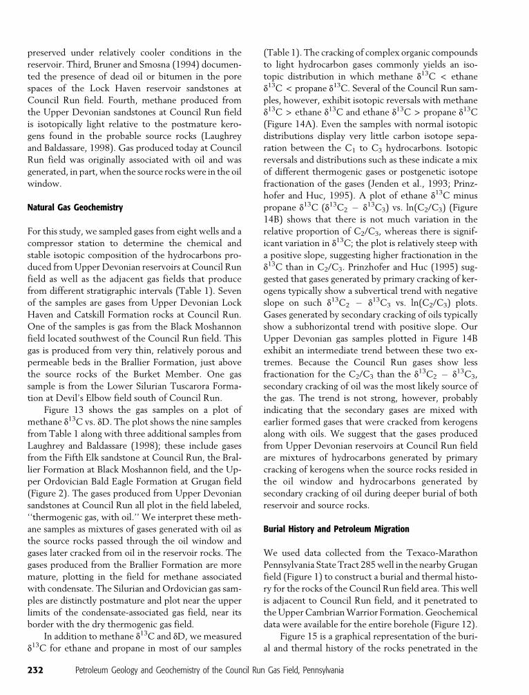
(Table 1). The cracking of complex organic compounds
to light hydrocarbon gases commonly yields an iso-
topic distribution in which methane d13C < ethane
d13C < propane d13C. Several of the Council Run sam-
ples, however, exhibit isotopic reversals with methane
d13C > ethane d13C and ethane d13C > propane d13C
(Figure 14A). Even the samples with normal isotopic
distributions display very little carbon isotope sepa-
ration between the C1 to C3 hydrocarbons. Isotopic
reversals and distributions such as these indicate a mix
of different thermogenic gases or postgenetic isotope
fractionation of the gases (Jenden et al., 1993; Prinz-
hofer and Huc, 1995). A plot of ethane d13C minus
propane d13C (d13C2 � d13C3) vs. ln(C2/C3) (Figure
14B) shows that there is not much variation in the
relative proportion of C2/C3, whereas there is signif-
icant variation in d13C; the plot is relatively steep with
a positive slope, suggesting higher fractionation in the
d13C than in C2/C3. Prinzhofer and Huc (1995) sug-
gested that gases generated by primary cracking of ker-
ogens typically show a subvertical trend with negative
slope on such d13C2 � d13C3 vs. ln(C2/C3) plots.
Gases generated by secondary cracking of oils typically
show a subhorizontal trend with positive slope. Our
Upper Devonian gas samples plotted in Figure 14B
exhibit an intermediate trend between these two ex-
tremes. Because the Council Run gases show less
fractionation for the C2/C3 than the d13C2 � d13C3,
secondary cracking of oil was the most likely source of
the gas. The trend is not strong, however, probably
indicating that the secondary gases are mixed with
earlier formed gases that were cracked from kerogens
along with oils. We suggest that the gases produced
from Upper Devonian reservoirs at Council Run field
are mixtures of hydrocarbons generated by primary
cracking of kerogens when the source rocks resided in
the oil window and hydrocarbons generated by
secondary cracking of oil during deeper burial of both
reservoir and source rocks.
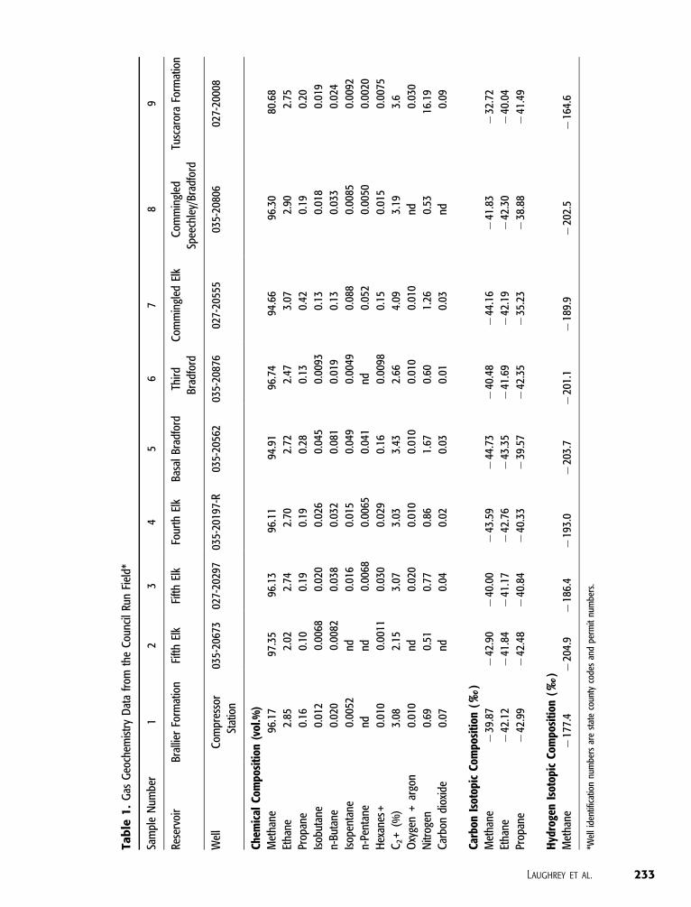
Burial History and Petroleum Migration
We used data collected from the Texaco-Marathon
Pennsylvania State Tract 285 well in the nearby Grugan
field (Figure 1) to construct a burial and thermal histo-
ry for the rocks of the Council Run field area. This well
is adjacent to Council Run field, and it penetrated to
the Upper Cambrian Warrior Formation. Geochemical
data were available for the entire borehole (Figure 12).
Figure 15 is a graphical representation of the buri-
al and thermal history of the rocks penetrated in the
232 Petroleum Geology and Geochemistry of the Council Run Gas Field, Pennsylvania
Tab
le1
.G
asG
eoch
emis
try
Dat
afr
omth
eC
ounc
ilRu
nFi
eld*
Sam
ple
Num
ber
12
34
56
78
9
Rese
rvoi
rBr
allie
rFo
rmat
ion
Fifth
Elk
Fifth
Elk
Four
thEl
kBa
sal
Brad
ford
Thir
d
Brad
ford
Com
min
gled
Elk
Com
min
gled
Spee
chle
y/Br
adfo
rd
Tusc
aror
aFo
rmat
ion
Wel
lC
ompr
esso
r
Stat
ion
035-
2067
302
7-20
297
035-
2019
7-R
035-
2056
203
5-20
876
027-
2055
503
5-20
806
027-
2000
8
Chem
ical
Com
posi
tion
(vol
.%)
Met
hane
96.1
797
.35
96.1
396
.11
94.9
196
.74
94.6
696
.30
80.6
8
Etha
ne2.
852.
022.
742.
702.
722.
473.
072.
902.
75
Prop
ane
0.16
0.10
0.19
0.19
0.28
0.13
0.42
0.19
0.20
Isob
utan
e0.
012
0.00
680.
020
0.02
60.
045
0.00
930.
130.
018
0.01
9
n-Bu
tane
0.02
00.
0082
0.03
80.
032
0.08
10.
019
0.13
0.03
30.
024
Isop
enta
ne0.
0052
nd0.
016
0.01
50.
049
0.00
490.
088
0.00
850.
0092
n-Pe
ntan
end
nd0.
0068
0.00
650.
041
nd0.
052
0.00
500.
0020
Hex
anes
+0.
010
0.00
110.
030
0.02
90.
160.
0098
0.15
0.01
50.
0075
C2+
(%)
3.08
2.15
3.07
3.03
3.43
2.66
4.09
3.19
3.6
Oxy
gen
+ar
gon
0.01
0nd
0.02
00.
010
0.01
00.
010
0.01
0nd
0.03
0
Nitr
ogen
0.69
0.51
0.77
0.86
1.67
0.60
1.26
0.53
16.1
9
Car
bon
diox
ide
0.07
nd0.
040.
020.
030.
010.
03nd
0.09
Carb
onIs
otop
icCo
mpo
siti
on(xx
)M
etha
ne�
39.8
7�
42.9
0�
40.0
0�
43.5
9�
44.7
3�
40.4
8�
44.1
6�
41.8
3�
32.7
2
Etha
ne�
42.1
2�
41.8
4�
41.1
7�
42.7
6�
43.3
5�
41.6
9�
42.1
9�
42.3
0�
40.0
4
Prop
ane
�42
.99
�42
.48
�40
.84
�40
.33
�39
.57
�42
.35
�35
.23
�38
.88
�41
.49
Hyd
roge
nIs
otop
icCo
mpo
siti
on(xx
)M
etha
ne�
177.
4�
204.
9�
186.
4�
193.
0�
203.
7�
201.
1�
189.
9�
202.
5�
164.
6
*Wel
lid
entif
icat
ion
num
bers
are
stat
eco
unty
code
san
dpe
rmit
num
bers
.
Laughrey et al. 233

State Tract 285 well. The burial curve was constructed
using software available from Platte River Associates and
Waples (1985). The amount of overburden removed
from the sedimentary section was determined from
sonic traveltime data using techniques described by
Magara (1976) and from vitrinite reflectance data using
a technique described by Price (1983). Our estimate of
3.8 km (2.36 mi) removed overburden agrees with an
estimate by Lacazette (1991) based on fluid-inclusion
data. Burial and erosion rates were taken from Beau-
mont et al. (1987) and Slingerland and Furlong (1989).
We based our thermal maturation model (Figure 15;
Table 2) on kerogen type IIc and oil-to-gas kinetics
published by Hunt and Hennet (1992) and Hunt
(1996).
Oil generation in the Devonian source rocks
(Burket Member and Marcellus Formation) started
when the rocks reached burial temperatures of 100j C
about 320 Ma and ended about 290 Ma, before
maximum burial to depths of approximately 6 km
(3.73 mi). As the shales were buried beyond the oil
window, liquid hydrocarbons remaining in the source
rocks were cracked to gas. Cracking began about 290
Ma and was completed about 270 Ma. Approximately
98% of any oil remaining in the source rocks was
cracked to gas by 270 Ma (Table 2).
Petroleum expelled from the Devonian source
rocks migrated through permeable beds in the Upper
Devonian Brallier Formation between 320 and 290 Ma
and accumulated in the sandstones of the Lock Haven
and Catskill formations. Dispersive migration paths
were probably both lateral and vertical (Mann et al.,
1997). Some accumulation might have continued until
270 Ma, when the reservoirs were buried to depths in
the deep gas window. Oil trapped in the Lock Haven
and Catskill formations reservoirs was progressively
cracked to gas between 270 and 240 Ma during deepest
burial and initial uplift. About 87.5% of this oil was
cracked to gas before relatively rapid uplift removed the
rocks from extreme maturation depths (Table 2).
IMPLICATIONS FOR PETROLEUM EXPLORATIONIN NORTH CENTRAL PENNSYLVANIA
The Council Run field is one of the most productive
gas fields in the central Appalachian basin. The pe-
troleum geology and geochemistry of the field pro-
vided an exploration and development model useful
for searching for similar accumulations in regions
deemed nonprospective by conventional wisdom, par-
ticularly in terms of reservoir stratigraphy and thermal
maturation. The principal reservoir sandstones at Coun-
cil Run are stratigraphic traps that were deposited during
a Late Devonian (late Frasnian–early Famennian) third-
order transgressive-regressive cycle, approximately
380 Ma. The most important reservoirs occur in a dis-
tinct fourth-order type 1 stratigraphic sequence that
begins at the base of the Fifth Elk sandstone and ends at
the base of the Third Bradford sandstone. The latter is
also an important reservoir in some parts of the field.
We interpret the tripartite vertical succession of pre-
dominantly coarse (lowstand), fine (transgressive), and
coarse (highstand) lithologies observed in the respec-
tive systems tracts of this sequence as evidence for
incised-valley-fill sediments. The incised valley prob-
ably is an integral component of the stratigraphic en-
trapment observed at Council Run field. Lateral tran-
sitions from reservoir rock to seal are gradational in
Figure 13. Plot of methane d13C vs. methane dD for the gassamples in Table 1. Numbers correspond to sample numbersin Table 1. LBe is a Fifth Elk sample, LBb is a Brallier sample, andLB is a Bald Eagle Formation sample; all three are from Laughreyand Baldassare (1998). Compositional fields for various genetictypes of gases are modified from Schoell (1983). Ro scale is fromJenden et al. (1993).
234 Petroleum Geology and Geochemistry of the Council Run Gas Field, Pennsylvania
Figure 14. (A) d13C distribution in C1 to C3 hydrocarbons at Council Run field. (B) Plot of ethane d13C minus propane d13C vs. thenatural logarithm of the ratio of ethane to propane for gas samples in Table 1.
Figure 15. Burial and thermal history of the Paleozoic rocks along the Allegheny Front in north central Pennsylvania based ongeological and geochemical data from the Pennsylvania State Tract 285 well in the Grugan field. Stippled area depicts the oil window.Heavy lines represent stratigraphic positions of source rocks discussed in the text.
Laughrey et al. 235
the field and are caused by encasement of the sand-
stones in marine mudrock, internal lithologic hetero-
geneities, and sandstone diagenesis. These lateral tran-
sitions are responsible for less productive wells and
noneconomic segments in the reservoirs (Biddle and
Wielchowsky, 1994).
The most significant reservoir, the Fifth Elk sand-
stone, accumulated in marine-dominated delta-front
environments of the lowstand systems tract during a
forced regression. Reservoir quality in the sandstones
was highly modified by diagenesis during burial and
subsequent uplift of the rocks. Black shales in the
Burket Member of the Upper Devonian Harrell
Formation and the Middle Devonian Marcellus Forma-
tion are the probable source rocks of the gases pro-
duced at Council Run. These gases are a mixture of gas
generated in the oil window before maximum burial
of the Paleozoic rocks in the region and gas generated
by the conversion of oil to gas during deeper burial.
The source rocks are now overmature, and their gen-
erative potential is exhausted.
Exploration for other Lock Haven Formation and
Catskill Formation fields along the Allegheny Front
has been unsuccessful to date. Good-quality reservoir
rocks equivalent to the Fifth Elk sandstones were en-
countered southwest of Council Run field in Somerset
County, Pennsylvania, and Garret County, Maryland.
The sandstones drilled there were similar to those at
Council Run in terms of thickness, geometry, inter-
preted origin, and structural setting (Follador, 1993).
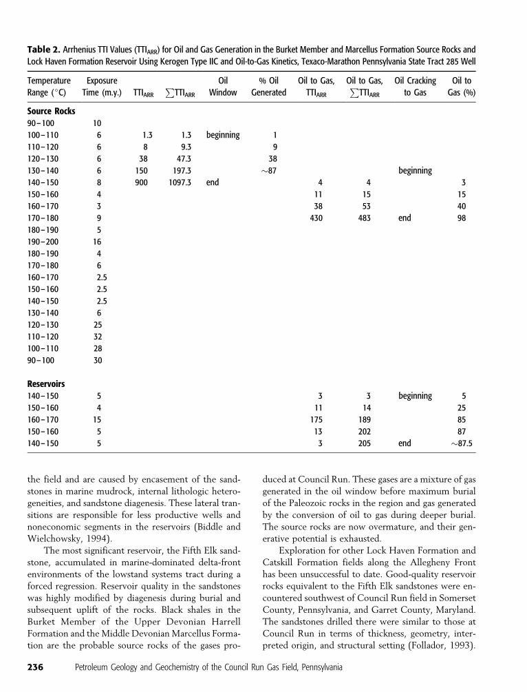
Table 2. Arrhenius TTI Values (TTIARR) for Oil and Gas Generation in the Burket Member and Marcellus Formation Source Rocks and
Lock Haven Formation Reservoir Using Kerogen Type IIC and Oil-to-Gas Kinetics, Texaco-Marathon Pennsylvania State Tract 285 Well
Temperature
Range (jC)
Exposure
Time (m.y.) TTIARR
PTTIARR
Oil
Window
% Oil
Generated
Oil to Gas,
TTIARR
Oil to Gas,P
TTIARR
Oil Cracking
to Gas
Oil to
Gas (%)
Source Rocks90–100 10
100–110 6 1.3 1.3 beginning 1
110–120 6 8 9.3 9
120–130 6 38 47.3 38
130–140 6 150 197.3 �87 beginning
140–150 8 900 1097.3 end 4 4 3
150–160 4 11 15 15
160–170 3 38 53 40
170–180 9 430 483 end 98
180–190 5
190–200 16
180–190 4
170–180 6
160–170 2.5
150–160 2.5
140–150 2.5
130–140 6
120–130 25
110–120 32
100–110 28
90–100 30
Reservoirs140–150 5 3 3 beginning 5
150–160 4 11 14 25
160–170 15 175 189 85
150–160 5 13 202 87
140–150 5 3 205 end �87.5
236 Petroleum Geology and Geochemistry of the Council Run Gas Field, Pennsylvania

Bruner and Smosna (1994) documented the presence
of porosity preserved by dead oil in these sandstones
just like that observed at Council Run field. Follador
(1993) suggested that faulting and fracturing might
have allowed previously trapped hydrocarbons to
escape, and that source bed intervals in that area are
significantly thinner than those present at Council
Run. Minor oil production from the Lock Haven Forma-
tion occurs at Brace Creek field northeast of Council
Run (Figure 1), but no significant petroleum accu-
mulations have been found in that vicinity. Interestingly
enough, Lock Haven Formation sandstones southwest
and northeast of Council Run field are thicker than
those at Council Run and were deposited in open
deltaic and ramp environments (Warne and McGhee,
1991; Follador, 1993; Castle, 2000) as opposed to the
interpreted incised-valley-fill deposits discussed in this
report. Hydrocarbon entrapment in these other re-
gions was not as effective as it was at Council Run
field. We attribute this to less structural complexity at
Council Run than elsewhere along the Allegheny Front,
thicker source rocks and shorter migration routes, rel-
atively lower maturation temperature exposures, and
faster uplift rates during the Alleghanian orogeny.
We also suspect that the incised valley interpreted at
Council Run is a subtle but integral component of
the stratigraphic trap there.
We suggest exploration for similar Lock Haven
sandstone reservoirs to the west of Council Run field,
where additional lowstand deposits might occur, par-
ticularly where coarse sediments could have further
bypassed the exposed ramp during progressive sea
level fall and sandstones might have accumulated in
lower shoreface, deltaic, or shelf fan environments (Van
Wagoner et al., 1990). Indeed, the relative thinness
of the Lock Haven and Catskill strata penetrated at
Council Run field and exposed along the nearby Al-
legheny Front (Warne and McGhee, 1991) may reflect
sediment bypass through an efficient incised-valley
transport system. Recent discoveries of gas in the
Fifth Elk sandstone and associated strata in Clear-
field County, Pennsylvania, 50 km (31.2 mi) west-
southwest of Council Run field may be in such reser-
voirs (Figure 16).
GR Figure 16. Geophysical logof the Beckman 5 well in therecently developed Hepburniapool, Lumber City field in Clear-field County, Pennsylvania. Thepool is 50 km (31.2 mi) west-southwest of the Council Runfield and has significant gasproduction from the Fifth Elksandstone. Note the similarityof the coarsening-upward para-sequences in the Fifth Elk inthis well’s gamma-ray (GR) log(1286–1300 m [4220–4266 ft])to those found in the Fifth Elk atCouncil Run (Figures 9, 10). Theleft and right borders of track 2are 60 and 65jF, respectively,for the temperature log scale.
Laughrey et al. 237

We interpret the critical moment at Council Run
field, i.e., that point in time when the generation-
migration-accumulation of most hydrocarbons in the
Marcellus/Burket–Lock Haven/Catskill petroleum
system took place, as having occurred between 260
and 240 Ma, when most of the oil in the petroleum
system was cracked to gas. Preservation time has been
relatively long and was controlled by the rapid rate of
uplift and denudation that occurred during Permian
time as well as during Mesozoic extension (Slingerland
and Furlong, 1989). A petroleum systems approach
(Magoon and Dow, 1994) provides the best analytical
tools for finding and developing other such accumula-
tions in areas of the central Appalachian basin that are
removed from the principal producing fields of the
province.
REFERENCES CITED
Al-Mugheiry, M. N., 1995, Depositional environments andsequence stratigraphic framework of the Late Devonian Elkreservoir sands in central Pennsylvania: M.S. thesis, Pennsyl-vania State University, 56 p.
Bayer, K. C., 1982, Map showing approximate eastern limit ofcommercial oil and gas fields in relation to structural fea-tures and physiographic provinces in the Appalachian region:U.S. Geological Survey Oil and Gas Investigations, ChartOC-121, 1:1,000,000, 2 sheets.
Beaumont, C., G. M. Quinlan, and J. Hamilton, 1987, The Alleg-hanian and its relationship to the evaluation of the easterninterior, North America, in C. Beaumont and A. J. Tamkand,eds., Sedimentary basins and basin-forming mechanisms: Ca-nadian Society of Petroleum Geologists Memoir 12, p. 425–445.
Bernard, H. A., C. F. Major Jr., B. S. Parrott, and R. J. LeBlanc Sr.,1970, Recent sediments of southeast Texas: Bureau ofEconomic Geology Guidebook, v. 11, 98 p.
Biddle, K. T., and C. C. Wielchowsky, 1994, Hydrocarbon traps, inL. B. Magoon and W. G. Dow, eds., The petroleum system—From source to trap: AAPG Memoir 60, p. 219–235.
Billman, D. A., R. Smosna, and K. R. Bruner, 1991, Petrology,porosity development, and diagenesis of the Upper DevonianElk sands, Council Run field, Centre and Clinton Counties,Pennsylvania (abs.): AAPG Bulletin, v. 75, p. 1379.
Brown, L. F. Jr., 1979, Deltaic sandstones of the mid-continent, inN. J. Hyne, ed., Pennsylvanian sandstones of the mid-continent:Tulsa Geological Society Special Publication 1, p. 35–63.
Bruner, K. R., and R. Smosna, 1994, Porosity development inDevonian lithic sandstones of the Appalachian foreland basin:Northeastern Geology, v. 16, p. 202–214.
Castle, J. W., 2000, Recognition of facies, bounding surfaces, andstratigraphic patterns in foreland-ramp successions: An exam-ple from the Upper Devonian, Appalachian basin, U.S.A.:Journal of Sedimentary Research, v. 70, p. 896–912.
Coleman, J. M., and D. B. Prior, 1982, Deltaic environments ofdeposition, in P. A. Scholle and D. Spearing, eds., Sandstonedepositional environments: AAPG Memoir 31, p. 139–178.
Cornell, J. R., 1971, Future petroleum potential of eastern
Pennsylvania, in I. H. Cram, ed., Future petroleum provincesof the United States— Their geology and potential: AAPGMemoir 15, p. 1243–1247.
Cotter, E., and S. G. Driese, 1998, Incised-valley fills and otherevidence of sea-level fluctuations affecting deposition of theCatskill Formation (Upper Devonian), Appalachian forelandbasin, Pennsylvania: Journal of Sedimentary Research, v. 68,p. 347–361.
Dennison, J. M., 1985, Catskill delta shallow marine strata, in D. L.Woodrow and W. D. Sevon, eds., The Catskill delta: Geol-ogical Society of America Special Paper 201, p. 91–106.
Donaldson, A., R. Boswell, X. Zou, L. Cavallo, L. R. Heim, and M.Canich, 1996, Upper Devonian Elk sandstones and siltstones,in J. B. Roen and B. J. Walker, eds., The atlas of major Appa-lachian gas plays: West Virginia Geological and EconomicSurvey Publication, v. 25, p. 77–85.
Elliott, T., 1978, Clastic shorelines, in H. G. Reading, ed., Sedimen-tary environments and facies: New York, Elsevier, p. 143–177.
Elliott, T., 1978, Deltas, in H. G. Reading, ed., Sedimentaryenvironments and facies: New York, Elsevier, p. 97–142.
Faill, R. T., R. B. Wells, and W. D. Sevon, 1977, Geology andmineral resources of the Linden and Williamsport quadrangles,Lycoming County, Pennsylvania: Pennsylvania GeologicalSurvey, 4th series, Atlas 134ab, 66 p.
Faill, R. T., A. D. Glover, and J. H. Way, 1989, Geology and mineralresources of the Blandburg, Tipton, Altoona, and Bellwoodquadrangles, Blair, Cambria, Clearfield, and Centre Counties:Pennsylvania Geological Survey, 4th series, Atlas 86, 209 p.
Follador, R. M., 1993, Geology of the lower Elk sandstone of theUpper Devonian Foreknobs Formation in Garrett County,Maryland and southern Somerset County, Pennsylvania: M.S.thesis, West Virginia University, 87 p.
Harper, J. A., and C. L. Cozart, 1982, Oil and gas developments inPennsylvania with ten-year review and forecast: PennsylvaniaGeological Survey, 4th series, Progress Report 204, 85 p.
Harper, J. A., C. D. Laughrey, and W. S. Lytle, 1982, Oil and gasfields of Pennsylvania: Pennsylvania Geological Survey, 4thseries, Map 3, scale 1:250,000, 2 sheets.
Harris, A. G., 1979, Conodont color alteration, an organo-mineralmetamorphic index, and its application to Appalachian basingeology, in P. A. Scholle and P. R. Schluger, eds., Aspects ofdiagenesis: SEPM Special Publication 26, p. 3–16.
Humphrey, J. F., P. A. Babasick, and R. J. Davis, 1994, Delineationof a regional meander belt using the Formation Microscannerand other wireline log data, Upper Devonian Third Bradfordsand, Centre, Clinton, and Lycoming Counties, Pennsylvania(abs.): AAPG Bulletin, v. 78, p. 1330.
Hunt, J. M., 1996, Petroleum geology and geochemistry: New York,Freeman, 743 p.
Hunt, J. M., and R. J.-C. Hennet, 1992, Modeling petroleumgeneration in sedimentary basins, in J. Whelan and J. Far-rington, eds., Organic matter: Productivity, accumulation, andpreservation in recent and ancient sediments: New York,Columbia University Press, p. 20–52.
Johnson, J. G., G. Klapper, and C. A. Sandberg, 1985, Devonianeustatic fluctuations in Euramerica: Geological Society ofAmerica Bulletin, v. 96, p. 567–587.
Jenden, P. D., D. J. Drozan, and I. R. Kaplin, 1993, Mixing of ther-mogenic natural gases in northern Appalachian basin: AAPGBulletin, v. 77, p. 980–988.
Kelleher, G., and R. Johnson, 1991, An integrated explorationmodel for Council Run field analogs: Regional geology andseismic stratigraphy of Devonian ‘‘6th’’ Elk sandstone (abs.):AAPG Bulletin, v. 75, p. 1385–1386.
Lacazette, A. J., 1991, Natural hydraulic fracturing in the Bald Eaglesandstone in central Pennsylvania and the Ithaca siltstone at
238 Petroleum Geology and Geochemistry of the Council Run Gas Field, Pennsylvania

Watkins Glen, New York: Ph.D. thesis, Pennsylvania StateUniversity, State College, Pennsylvania, 225 p.
Laughrey, C. D., 1997, Petroleum source rocks in Pennsylvania: Penn-sylvania Geological Survey, 4th series, Open-File Report, 80 p.
Laughrey, C. D., and F. J. Baldassare, 1998, Geochemistry andorigin of some natural gases in the Plateau Province, centralAppalachian basin, Pennsylvania and Ohio: AAPG Bulletin,v. 82, p. 317–335.
Laughrey, C. D., and R. M. Harper, 1996, Upper Ordovician BaldEagle Formation fractured anticlinal play, in J. B. Roen and B. J.Walker, eds., The atlas of major Appalachian gas plays: WestVirginia Geological and Economic Survey Publication, v. 25,p. 164–167.
Magara, K., 1976, Thickness of removed sedimentary rocks,paleopore pressure, and paleotemperature, southwestern partof western Canada basin: AAPG Bulletin, v. 60, p. 554–565.
Magoon, L. B. and W. G. Dow, 1994, The petroleum system, inL. B. Magoon and W. G. Dow, eds., The petroleum system—From source to trap, AAPG Memoir 60, p. 3–24.
Mann, U., T. Hantschel, R. G. Schaefer, B. Krooss, D. Leythaeuser,R. Littke, and R. F. Sachsenhofer, 1997, Petroleum migration:Mechanisms, pathways, efficiencies, and numerical simula-tions, in D. H. Welte, B. Horsfield, and D. R. Baker, eds.,Petroleum and basin evaluation: Berlin, Springer, p. 403–520.
Milici, R. C., 1993, Autogenic gas (self-sourced) from shales— Anexample from the Appalachian basin, in D. G. Howell, K.Wiese, M. Fanelli, L. Zink, and F. Cole, eds., The future ofenergy gases: U.S. Geological Survey Professional Paper 1570,p. 253–278.
Peters, K. E., and M. R. Casa, 1994, Applied source rock geochem-istry, in L. B. Magoon and W. G. Dow, eds., The petroleumsystem— From source to trap: AAPG Memoir 60, p. 93–120.
Peters, K. E., and J. M. Moldowan, 1993, The biomarker guide:Englewood Cliffs, New Jersey, Prentice Hall, 363 p.
Pettijohn, F. J., P. E. Potter, and R. Siever, 1987, Sand andsandstones: New York, Springer-Verlag, 553 p.
Platte River Associates, Inc., and D. W. Waples, 1985, ‘‘From hereto maturity,’’ a time-temperature maturation modeling pro-gram: Platte River Associates, Inc., Denver, Colorado.
Posamentier, H. W., and G. P. Allen, 1993, Siliciclastic sequencestratigraphic patterns in foreland ramp-type basins: Geology,v. 21, p. 455–458.
Posamentier, H. W., G. P. Allen, D. P. James, and M. Tesson, 1992,Forced regressions in a sequence stratigraphic framework: Con-cepts, examples, and exploration significance: AAPG Bulletin,v. 76, p. 1687–1709.
Potter, P. E., J. B. Maynard, and W. A. Pryor, 1980, Sedimentologyof shale: New York, Springer-Verlag, 303 p.
Price, L. C., 1983, Geologic time as a parameter in organic meta-morphism and vitrinite reflectance as an absolute paleogeo-thermometer: Journal of Petroleum Geology, v. 6, p. 5–38.
Prinzhofer, A. A., and A. Y. Huc, 1995, Genetic and postgeneticmolecular and isotopic fractionations in natural gases: Chem-ical Geology, v. 126, p. 281–290.
Rahmanian, V. D., 1979, Stratigraphy and sedimentology of theUpper Devonian Catskill and Trimmers Rock formations incentral Pennsylvania: Ph.D. thesis, Pennsylvania State Univer-sity, State College, Pennsylvania, 340 p.
Reineck, H. E., and I. B. Singh, 1980, Depositional sedimentaryenvironments: Berlin, Springer-Verlag, 549 p.
Reinson, G. E., 1979, Facies model 6. Barrier island systems, inR. G. Walker, ed., Facies models: Geoscience Canada ReprintSeries 1, Geological Association of Canada, p. 57–74.
Ryder, R. T., 1995, Appalachian basin province, in D. L. Gautier,G. L. Dolton, K. I. Takahashi, and K. L. Varnes, eds., 1995National assessment of United States oil and gas resources—Results, methodology, and supporting data: U.S. GeologicalSurvey Digital Data Series DDS-30.
Schmidt, V., and D. A. McDonald, 1979, Texture and recognitionof secondary porosity in sandstones, in P. A. Scholle and P. R.Schluger, eds., Aspects of diagenesis: SEPM Special Publica-tion 26, p. 209–225.
Schoell, M., 1983, Genetic characteristics of natural gases: AAPGBulletin, v. 67, p. 2225–2238.
Slingerland, R., and K. P. Furlong, 1989, Geodynamic and geo-morphic evolution of the Permo-Triassic Appalachian Moun-tains, in T. W. Gardner and W. D. Sevon, eds., Appalachiangeomorphology: Amsterdam, Elsevier, p. 23–37.
Slingerland, R., and J.-P. Loule, 1988, Wind/wave and tidal processesalong the Upper Devonian Catskill shoreline in Pennsylvania,U.S.A., in N. J. McMillian, A. F. Embry, and D. J. Glass, eds.,Devonian of the world: Canadian Society of Petroleum Geo-logists Memoir 14, v. II, Sedimentation, p. 125–138.
Smosna, R., and K. R. Bruner, 1997, Depositional controls overporosity development in lithic sandstones of the Appalachianbasin: Reducing exploration risk, in J. A. Kupecz, J. Gluyas,and S. Bloch, eds., Reservoir quality prediction in sandstonesand carbonates: AAPG Memoir 69, p. 249–265.
Streib, D. L., 1981, Distribution of gas, organic carbon, and vitrinitereflectance in the eastern Devonian gas shales and their rela-tionship to the geologic framework: U.S. Department ofEnergy Report, Contract No. DOE/MC/08216-1276, METC,71c, 262 p.
Taylor, A. F., 1997, Geology and mineral resources of the LockHaven quadrangle, Clinton and Lycoming Counties, Pennsyl-vania: Pennsylvania Geological Survey, 4th series, Atlas 124a,scale 1:24,000, 1 sheet.
Van Wagoner, J. C., H. W. Posamentier, and R. M. Mitchum Jr.,1988, An overview of the fundamentals of sequence stratig-raphy and key definitions, in C. K. Wilgus, H. W. Posamentier,C. A. Ross, C. G. St. C. Kendall, and J. C. Van Wagoner, eds.,Sea-level changes: An integrated approach: SEPM SpecialPublication 42, p. 39–45.
Van Wagoner, J. C., R. M. Mitchum, K. M. Campion, and V. D.Rahmanian, 1990, Siliciclastic sequence stratigraphy in welllogs, cores, and outcrops: Concepts for high-resolution corre-lation of time and facies: AAPG Methods in Exploration SeriesNo. 7, 55 p.
Warne, A. G., 1986, Stratigraphic analysis of the Upper DevonianGreenland Gap Group and Lock Haven Formation near theAllegheny Front of central Pennsylvania: M.S. thesis, RutgersUniversity, New Brunswick, New Jersey, 219 p.
Warne, A. G., and G. R. McGhee Jr., 1991, Stratigraphic sub-divisions of the Upper Devonian Scherr, Foreknobs, and LockHaven formations near the Allegheny Front of central Penn-sylvania: Northeastern Geology, v. 13, p. 96–109.
Laughrey et al. 239