phosphate mining: borrowed land - florida industrial and...
TRANSCRIPT

2012, FLORIDA INDUSTRIAL AND PHOSPHATE RESEARCH INSTITUTE 1855 West Main Street • Bartow, FL 33830-7718
(863) 534-7160 • Fax (863) 534-7165 • www.fipr.state.fl.us
Phosphate Mining: Borrowed Land
A middle school grade level unit
created by
Teresa Urban
Lawton Chiles Middle Academy
Polk County, FL

Phosphate Mining: Borrowed Land 2
FLORIDA INDUSTRIAL AND PHOSPHATE RESEARCH INSTITUTE
DISCLAIMER
The contents of this teaching unit are reproduced herein as received from the teachers who
authored the unit. The unit has been peer-reviewed and edited in compliance with the FIPR
Institute Education Program lesson plan style.
Mention of company names or products does not constitute endorsement by the Florida
Industrial and Phosphate Research Institute.
Phosphate Mining: Borrowed Land 3
FLORIDA INDUSTRIAL AND PHOSPHATE RESEARCH INSTITUTE
Unit Summary
Dear Teachers,
I believe that middle school students know that human activities have had an impact on the global
environment; erosion, deforestation, water quality, etc. They have watched television documentaries
and movies that depict the destruction of large areas of tropical rain forests. Students read about
water pollution and soil erosion in textbooks. Do we want to simply tell students about global
environmental problems and assume they will become good stewards of the land? Let’s bring these
issues down to the local level and allow students to get involved and actually participate in
environmental problem solving.
This unit is designed to provide students with hands-on experience working on a local land area that
has been disturbed by either phosphate mining, farming, development and other human activities.
Using technology applications they learn about phosphate mining processes, natural communities
where the mining takes place, and the methods and trials associated with land reclamation. Using this
knowledge students create a working plan to improve a disturbed land site.
The learning lessons for Phosphate Mining: Borrowed Land include the following key activities:
Phosphate mining in central Florida, manufacturing crop nutrients and land reclamation
learning video and technology application.
Using GPS technology to simulate core hole sampling techniques used by geologists to locate
and measure phosphate deposits before mining.
PowerPoint lesson on earth’s elemental cycles with a technology application on the
phosphorus cycle.
On-site learning activity where students recognize various natural communities and their
characteristics with a follow-up technology application.
Learning activity—game style—where students understand the role of phosphate mining
companies to preserve the habitat of the endangered gopher tortoise and learn about
reclamation technology.
A culminating activity where students plan and implement a reclamation-type project to
improve a small land area either on school grounds or a nearby park or wildlife preserve.
Eighth graders at LCMA have participated in these activities. The student-created video documents
(Resource CD)—Gopher Tortoise and Cogongrass: Invasive Plants—show how these students
enthusiastically participated in a local reclamation project. They were proud to participate in a project
that allowed them to create a solution to a local environmental problem. Students seemed to
appreciate the trials and challenges of the scientists and experts working on land reclamation.
For suggestions about local areas to visit and funding for supplies and field trips contact me via
email: [email protected].

Phosphate Mining: Borrowed Land 4
FLORIDA INDUSTRIAL AND PHOSPHATE RESEARCH INSTITUTE
Perspective
Phosphate is mined in Florida and is an integral part of the economy of Central Florida.
Phosphate is used to make fertilizer used for agriculture, returning phosphorus to the soil so
crops can grow. When the crops are consumed phosphorus returns to living things to fuel
biochemical processes in cells and make deoxyribonucleic acid (DNA). Phosphate is also used
in thousands of other common household items and plays a key role in our everyday life. As we
mine phosphate to support our economy and our daily life, the environment is disturbed and
human activities such as this impacting the global environment.
Humans have a major impact on the global environment. It is up to humans to fix the negative
impacts we cause. Our impact on the global environment not only affects our species but also
affects entire habitats and the plant and animal species that live within them. The word global
can give the impression that the solution should be someone else’s problem. However, human
impact begins on the local level. In Florida, the land has been disturbed by mining, farming, and
other human activities. Florida law requires that some of the environmental problems be solved.
Mining has been regulated and since 1975 reclamation is mandatory. Further information on
reclamation and regulations can be found on our webpage at
http://www.fipr.poly.usf.edu.
This unit should benefit teachers by making the issues we face local, so their students can
become a part of the solution to the environmental problems we face in Florida. The unit begins
with the mining process but also teaches about the natural communities where the mining is
taking place, and finally explores reclamation of the natural communities that were mined. This
demonstrates that the land mined is just as important as the phosphate that came out of it.
Teresa Urban has used the information she has learned about phosphate mining and reclamation
as both an attendee and facilitator at our FIPR Institute Summer Workshops to create this unit
with her eighth grade students. Students used scientific inquiry to understand the value of land
during mining by using technology such as GPS to simulate the core sampling techniques used
by geologists. A lesson on the role of the phosphorus cycle in a natural community allows
students to understand the characteristics they will encounter during an on-site natural
community learning activity. They will then go in depth and focus on a species that is
endangered in Florida, the gopher tortoise in order to understand the role of phosphate
companies in the preservation of habitats. Finally, the students will demonstrate all they have
learned by planning and implementing a reclamation-type project in their community.
This unit will help both teachers and students understand the entire process of mining in
relationship to the land that is being borrowed and will bring local awareness to this global issue.
Phosphate Mining: Borrowed Land 5
FLORIDA INDUSTRIAL AND PHOSPHATE RESEARCH INSTITUTE
Table of Contents
Concept Map 6
Next Generation Sunshine State Standards 7
Specific Objectives 11
List of Activities 12
Unit Vocabulary 13
Unit Vocabulary Definitions 14
Lesson Plans
1. Phosphate Mining in Central Florida 21
2. GPS Technology and Phosphate Mining 28
3. Phosphorus Cycle 35
4. Natural Communities of Central Florida 40
5. Gopher Tortoise 49
6. Schoolyard Reclamation 61
List of Materials 69
List of Resources 70
Phosphate Mining: Borrowed Land 6
FLORIDA INDUSTRIAL AND PHOSPHATE RESEARCH INSTITUTE
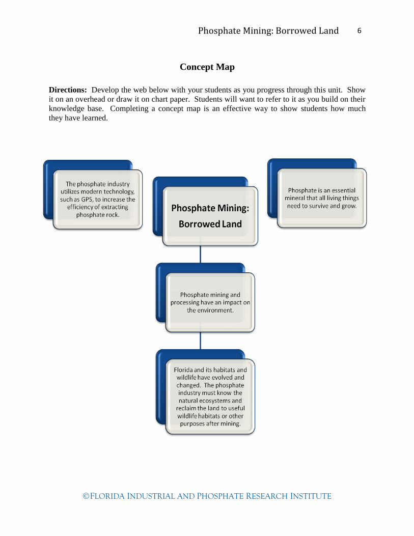
Concept Map
Directions: Develop the web below with your students as you progress through this unit. Show
it on an overhead or draw it on chart paper. Students will want to refer to it as you build on their
knowledge base. Completing a concept map is an effective way to show students how much
they have learned.
Phosphate Mining: Borrowed Land 7
FLORIDA INDUSTRIAL AND PHOSPHATE RESEARCH INSTITUTE
Next Generation Sunshine State Standards
Science Benchmarks
SC.6.N.1.4 Discuss, compare, and negotiate methods used, results obtained, and explanations
among groups of students conducting the same investigation.
SC.7.E.6.2 Identify the patterns within the rock cycle and relate them to surface events
(weathering and erosion) and sub-surface events (plate tectonics and mountain
building).
SC.7.E.6.6 Identify the impact that humans have had on Earth, such as deforestation,
urbanization, desertification, erosion, air and water quality, changing the flow of
water.
SC.7.L.17.1 Explain and illustrate the roles of and relationships among producers, consumers,
and decomposers in the process of energy transfer in a food web.
SC.7.L.17.2 Compare and contrast the relationships among organisms such as mutualism,
predation, parasitism, competition, and commensalism.
SC.7.L.17.3 Describe and investigate various limiting factors in the local ecosystem and their
impact on native populations, including food, shelter, water, space, disease,
parasitism, predation, and nesting sites.
SC.7.N.1.1 Define a problem from the seventh grade curriculum, use appropriate reference
materials to support scientific understanding, plan and carry out scientific
investigation of various types, such as systematic observations or experiments,
identify variables, collect and organize data, interpret data in charts, tables, and
graphics, analyze information, make predictions, and defend conclusions.
SC.7.N.1.3 Distinguish between an experiment (which must involve the identification and
control of variables) and other forms of scientific investigation and explain that
not all scientific knowledge is derived from experimentation.
SC.7.N.1.4 Identify test variables (independent variables) and outcome variables (dependent
variables) in an experiment.
SC.7.N.1.5 Describe the methods used in the pursuit of a scientific explanation as seen in
different fields of science such as biology, geology, and physics.
SC.8.L.18.3 Construct a scientific model of the carbon cycle to show how matter and energy
are continuously transferred within and between organisms and their physical
environment.
Phosphate Mining: Borrowed Land 8
FLORIDA INDUSTRIAL AND PHOSPHATE RESEARCH INSTITUTE
SC.8.L.18.4 Cite evidence that living systems follow the Laws of Conservation of Mass and
Energy.
SC.8.N.4.1 Explain that science is one of the processes that can be used to inform decision
making at the community, state, national, and international levels.
Language Arts Benchmarks
LA.6.3.5.2 The student will use elements of spacing and design for graphics (e.g., tables,
drawings, charts, graphs) when applicable to enhance the appearance of the
document.
LA.6.4.2.2 The student will record information (e.g., observations, notes, lists, charts,
legends) related to a topic, including visual aids to organize and record
information and include a list of sources used,
LA.6.4.3.1 The student will write persuasive text (e.g., advertisement, speech, essay, public
service announcement) that establishes and develops a controlling idea, using
appropriate supporting arguments and detailed evidence.
LA.6.4.3.2 The student will include persuasive techniques (e.g., word choice, repetition,
emotional appeal, hyperbole, appeal to authority, celebrity endorsement).
LA.6.5.2.1 The student will listen and gain information for a variety of purposes, (e.g.,
clarifying, elaborating, summarizing main ideas and supporting details).
LA.6.5.2.2 The student will deliver narrative and informative presentations, including oral
responses to literature, and adjust oral language, body language, eye contact,
gestures, technology and supporting graphics appropriate to the situation.
LA.6.6.4.2 The student will determine and apply digital tools (e.g., word processing,
multimedia authoring, web tools, graphic organizers) to publications and
presentations.
LA.7.3.5.2 The student will use elements of spacing and design for graphics (e.g., tables,
drawings, charts, graphs) when applicable to enhance the appearance of the
document.
LA.7.4.2.2 The student will record information (e.g., observations, notes, lists, charts,
legends) related to a topic, including visual aids to organize and record
information, as appropriate, and attribute sources of information.
LA.7.4.3.1 The student will write persuasive text (e.g., advertisement, speech, essay, public
service announcement) that establish and develop a controlling idea and
supporting arguments for the validity of the proposed idea with detailed evidence.

Phosphate Mining: Borrowed Land 9
FLORIDA INDUSTRIAL AND PHOSPHATE RESEARCH INSTITUTE
LA.7.4.3.2 The student will include persuasive techniques (e.g., word choice, repetition,
emotional appeal, hyperbole, appeal to authority, celebrity endorsement,
rhetorical question, irony).
LA.7.5.2.1 The student will use effective listening strategies for informal and formal
discussions, connecting to and building on the ideas of a previous speaker and
respecting the viewpoints of others when identifying bias or faulty logic.
LA.7.6.4.1 The student will select and use appropriate available technologies (e.g., computer,
digital camera) to enhance communication and achieve a purpose (e.g., video,
presentations).
LA.7.6.4.2 The student will evaluate and apply digital tools (e.g., word processing,
multimedia authoring, web tools, graphic organizers) to publications and
presentations.
LA.8.3.5.2 The student will use elements of spacing and design for graphics (e.g., tables,
drawings, charts, graphs) when applicable to enhance the appearance of the
document.
LA.8.4.2.2 The student will record information (e.g., observations, notes, lists, charts,
legends) related to a topic, including visual aids to organize and record
information, as appropriate, and attribute sources of information.
LA.8.4.3.1 The student will write persuasive text (e.g., advertisement, speech, essay, public
service announcement) that establishes and develops a controlling idea, and
supports arguments for the validity of the proposed idea with detailed evidence.
LA.8.4.3.2 The student will include persuasive techniques (e.g., word choice, repetition,
emotional appeal, hyperbole, appeal to authority, celebrity endorsement,
rhetorical question, irony, symbols, glittering generalities, card stacking).
LA.8.5.2.1 The student will demonstrate effective listening skills and behaviors for a variety
of purposes, and demonstrate understanding by paraphrasing and/or summarizing.
LA.8.5.2.2 The student will use effective listening and speaking strategies for informal and
formal discussions, connecting to and building on the ideas of a previous speaker
and respecting the viewpoints of others when identifying bias or faulty logic.
LA.8.6.4.1 The student will use appropriate available technologies to enhance
communication and achieve a purpose (e.g., video, digital technology).
LA.8.6.4.2 The student will evaluate and apply digital tools (e.g., word, processing,
multimedia authoring, web tools, graphic organizers) to publications and
presentations.
Phosphate Mining: Borrowed Land 10
FLORIDA INDUSTRIAL AND PHOSPHATE RESEARCH INSTITUTE
Math Benchmarks
MA.7.A.1.1 Distinguish between situations that are proportional or not proportional, and use
proportions to solve problems.
MA.8.S.3.1 Select, organize and construct appropriate data displays, including box and
whisker plots, scatter plots, and lines of best fit to convey information and make
conjectures about possible relationships.
Social Studies Benchmarks
SS.6.G.1.1 Use latitude and longitude coordinates to understand the relationship between
people and places on the Earth.
SS.6.G.1.2 Analyze the purposes of map projections (political, physical, special purpose) and
explain the applications of various types of maps.
SS.6.G.1.4 Utilize tools geographers use to study the world.
Phosphate Mining: Borrowed Land 11
FLORIDA INDUSTRIAL AND PHOSPHATE RESEARCH INSTITUTE
Specific Objectives
The students will…
Lesson 1
1. Learn the basic steps of phosphate mining, beneficiation processes, and the
manufacturing of granular crop nutrients.
2. Demonstrate the basic steps of phosphate mining, beneficiation processes, and the
manufacturing of granular crop nutrients.
Lesson 2
1. Use a GPS receiver to locate given waypoints on school grounds—the locations of core
samples.
2. Draw a sectional phosphate ore location map using data from the core samples.
3. Analyze their drawings to determine the approximate depth of the phosphate ore.
Lesson 3
1. Gain knowledge about the phosphorus cycle and development of phosphate deposits in
Florida.
2. Apply their knowledge of the phosphorus cycle by generating an electronic drawing of
the cycle.
Lesson 4
1. Recognize biotic and abiotic factors in a natural plant community.
2. Observe and note the unique characteristics of natural plant communities.
3. Compare and contrast two different natural plant communities.
4. Describe the impact that human action has had on nearby natural plant communities.
Lesson 5
1. Describe the problems of the gopher tortoise’s survival and cause of its habitat loss.
2. Draw inferences about the effects of limiting factors on gopher tortoises.
3. Describe efforts to protect gopher tortoises made by mining companies, commercial and
housing developers, and private or government agencies.
4. Communicate ways in which the public can protect and preserve gopher tortoises, their
burrows and habitats.
Lesson 6
1. Analyze abiotic and biotic factors existing in a given land area.
2. Identify the impact of human activities on this land area.
3. Describe the tested methods used to eradicate invasive/exotic plants.
4. Explain the competition between native and invasive/exotic plants in Florida’s natural
communities.
5. Identify the independent and dependent variables in an investigation to eradicate
invasive/exotic plants from a given land area.
Phosphate Mining: Borrowed Land 12
FLORIDA INDUSTRIAL AND PHOSPHATE RESEARCH INSTITUTE
List of Activities
Lesson 1—Phosphate Mining in Central Florida
The Phosphate Story: Florida’s Hidden Treasure Worksheet 24
The Phosphate Story: Florida’s Hidden Treasure Answer Key 26
Phosphate Mining—Sample Flow Chart 27
Lesson 2—GPS Technology and Phosphate Mining
GPS and Core Sample Simulation 29
Core Sample Data Chart 34
Lesson 3—Phosphorus Cycle
PowerPoint-Cycles of Matter on Earth 37
Carbon Cycle Game 37
Phosphorus Cycle Drawing Checklist 39
Lesson 4—Natural Communities of Central Florida
Soil pH 41
Field Trip 42
Students Create PowerPoint of Difference in Sites Visited 42
Natural Community Comparison Chart 48
Lesson 5—Gopher Tortoise
PowerPoint-Gopher Tortoise: A Species in Decline 51
Survival: The Gopher Tortoise Game 53
Assessment Project 51
Lesson 6—Schoolyard Reclamation
Field Trip and Site Map 62
Plan for Site Improvement 62
Research, Plan and Write Investigation for Invasive Plant Removal 62
Invasive Plant Eradication Investigation Worksheet 64
Extensions:
Lesson 1
Kids Dig It! Parts 1 and 2 23
Lesson 4
Create a Poster of a Natural Community in Florida 42
Lesson 5
Site Survey of Gopher Tortoise Burrows 51
Gopher Tortoise Burrow Survey Worksheet 60
Phosphate Mining: Borrowed Land 13
FLORIDA INDUSTRIAL AND PHOSPHATE RESEARCH INSTITUTE
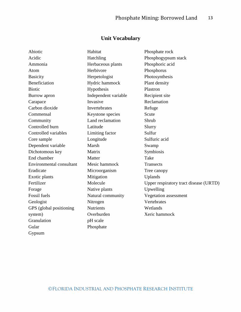
Unit Vocabulary
Abiotic
Acidic
Ammonia
Atom
Basicity
Beneficiation
Biotic
Burrow apron
Carapace
Carbon dioxide
Commensal
Community
Controlled burn
Controlled variables
Core sample
Dependent variable
Dichotomous key
End chamber
Environmental consultant
Eradicate
Exotic plants
Fertilizer
Forage
Fossil fuels
Geologist
GPS (global positioning
system)
Granulation
Gular
Gypsum
Habitat
Hatchling
Herbaceous plants
Herbivore
Herpetologist
Hydric hammock
Hypothesis
Independent variable
Invasive
Invertebrates
Keystone species
Land reclamation
Latitude
Limiting factor
Longitude
Marsh
Matrix
Matter
Mesic hammock
Microorganism
Mitigation
Molecule
Native plants
Natural community
Nitrogen
Nutrients
Overburden
pH scale
Phosphate
Phosphate rock
Phosphogypsum stack
Phosphoric acid
Phosphorus
Photosynthesis
Plant density
Plastron
Recipient site
Reclamation
Refuge
Scute
Shrub
Slurry
Sulfur
Sulfuric acid
Swamp
Symbiosis
Take
Transects
Tree canopy
Uplands
Upper respiratory tract disease (URTD)
Upwelling
Vegetation assessment
Vertebrates
Wetlands
Xeric hammock
Phosphate Mining: Borrowed Land 14
FLORIDA INDUSTRIAL AND PHOSPHATE RESEARCH INSTITUTE
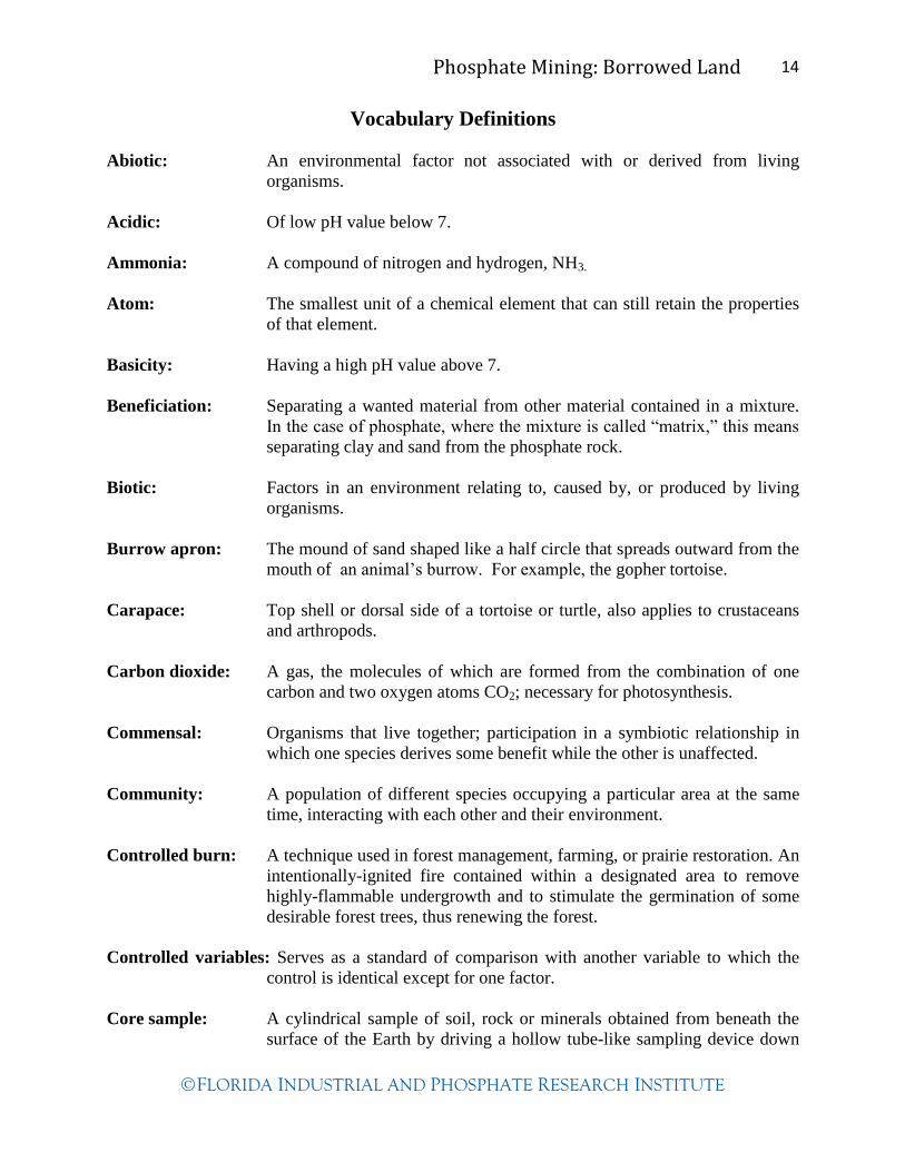
Vocabulary Definitions
Abiotic: An environmental factor not associated with or derived from living
organisms.
Acidic: Of low pH value below 7.
Ammonia: A compound of nitrogen and hydrogen, NH3.
Atom: The smallest unit of a chemical element that can still retain the properties
of that element.
Basicity: Having a high pH value above 7.
Beneficiation: Separating a wanted material from other material contained in a mixture.
In the case of phosphate, where the mixture is called “matrix,” this means
separating clay and sand from the phosphate rock.
Biotic: Factors in an environment relating to, caused by, or produced by living
organisms.
Burrow apron: The mound of sand shaped like a half circle that spreads outward from the
mouth of an animal’s burrow. For example, the gopher tortoise.
Carapace: Top shell or dorsal side of a tortoise or turtle, also applies to crustaceans
and arthropods.
Carbon dioxide: A gas, the molecules of which are formed from the combination of one
carbon and two oxygen atoms CO2; necessary for photosynthesis.
Commensal: Organisms that live together; participation in a symbiotic relationship in
which one species derives some benefit while the other is unaffected.
Community: A population of different species occupying a particular area at the same
time, interacting with each other and their environment.
Controlled burn: A technique used in forest management, farming, or prairie restoration. An
intentionally-ignited fire contained within a designated area to remove
highly-flammable undergrowth and to stimulate the germination of some
desirable forest trees, thus renewing the forest.
Controlled variables: Serves as a standard of comparison with another variable to which the
control is identical except for one factor.
Core sample: A cylindrical sample of soil, rock or minerals obtained from beneath the
surface of the Earth by driving a hollow tube-like sampling device down

Phosphate Mining: Borrowed Land 15
FLORIDA INDUSTRIAL AND PHOSPHATE RESEARCH INSTITUTE
into the ground to a specified depth, followed by careful extraction.
Dependent variable: Factor being measured or observed in an experiment.
Dichotomous key: A written or pictorial tool comprised of "couplets" describing mutually
exclusive qualities that allows the user to identify a specimen (usually of
natural origin) by choosing the best-fitting description.
End chamber: The final compartment to an animal’s burrow which is usually enlarged by
the animal to allow room to move around and rest comfortably; for
example the gopher tortoise.
Environmental Consultant: A biologist, geologist, chemist, or engineer with knowledge of
local biota, environmental systems, conditions and regulations that is hired
to give their professional judgment or opinion on possible environmental
impacts, oversee permitted work, or monitor conditions of the land, water,
air or living resources.
Eradicate: To completely remove an unwanted plant or animal.
Exotic: A species that is not indigenous (not native) to a region.
Fertilizer: Any natural or synthetic material that is chemically or naturally produced,
including manure and nitrogen, phosphorus, and potassium compounds,
spread on or worked into soil to increase its capacity to support plant
growth, quality and yield.
Forage: The act of collecting or searching for food and provisions.
Fossil fuels: Fuels that originate from ancient deposits of decomposing organisms.
Over millions of years, coal, oil, and natural gas have formed from these
deposits.
Geologist: A scientist who studies Earth’s origin, history, and structure, including the
rocks and minerals found in Earth’s crust.
GPS (global positioning system): A system of satellites, computers, and receivers that is able to
determine the latitude and longitude of a receiver on Earth by calculating
the time difference for signals from different satellites to reach the
receiver. The accuracy is usually within 4 meters.
Granulation: The process of making granules, or small grains or crystals of a product.
Gular: Referring to the area under the chin of some animals; the gular scale of the
male gopher tortoise is usually elongated and used in male-to-male
interactions to ram and flip the other male tortoise.

Phosphate Mining: Borrowed Land 16
FLORIDA INDUSTRIAL AND PHOSPHATE RESEARCH INSTITUTE
Gypsum: A finely-grained solid consisting primarily of calcium sulfate, either
naturally or chemically produced, in which case is referred to as
phosphogypsum.
Habitat: A place in an ecosystem where an organism normally lives.
Hatchling: An organism that has just left the egg.
Herbaceous plants: Non-woody plants.
Herbivore: An organism that consumes producers.
Herpetologist: A scientist that studies reptiles.
Hydric hammock: Poorly drained forested areas on sand/clay/organic soil, often over
limestone. Characteristic species include water oak, cabbage palm, red
cedar, red maple, bays, hackberry, hornbeam, black gum, needle palm, and
mixed hardwoods.
Hypothesis: A tentative explanation for an observation, phenomenon, or scientific
problem that can be tested by further investigation.
Independent variable: The factor that is changed in an experiment in order to study changes in
the dependent variable.
Invasive: Any species, including its seeds, eggs, spores, or other biological material
capable of propagating that species, that is not native to that ecosystem;
and whose introduction does, or is likely to, cause economic or
environmental harm or harm to human health.
Invertebrate: An animal that has no backbone or spinal column and therefore does not
belong to the subphylum Vertebrata of the phylum Chordata. Invertebrates
are the most numerous animals. Corals, insects, worms, jellyfish, starfish,
and snails are examples of invertebrates.
Keystone species: A species that is critical to the functioning of the ecosystem in which it
lives because it affects the survival and abundance of many other species
in its community.
Land reclamation: The process of restoring a site that has sustained environmental
disturbance. This is done to minimize environmental impact and/or to
allow for some form of human use. Usually involves soil moving, filling
and recontouring, ensuring appropriate hydrology, and, in the case of
reclamation to a wildlife habitat, the planting of appropriate native plant
species.

Phosphate Mining: Borrowed Land 17
FLORIDA INDUSTRIAL AND PHOSPHATE RESEARCH INSTITUTE
Latitude: A measure of relative position north or south on the Earth's surface,
measured in degrees from the equator, which has a latitude of 0°, with the
poles having a latitude of 90° north and south.
Limiting factor: An environmental variable that limits or slows the growth, activities, or
distribution of an organism or population.
Longitude: A measure of relative position east to west on the Earth's surface,
measured in degrees from the Prime Meridian (which is the longitude that
runs through Greenwich, England).
Marsh: A wetland area covered mostly by grasses.
Matrix: The phosphate-bearing layer or strata, consisting of phosphate rock, clay
and sand, usually found 15-50 feet below the ground surface in the Bone
Valley region of west central Florida.
Matter: Substance that possesses inertia and occupies space, of which all objects
are constituted.
Mesic hammock: Ecosystem where soils are moist but do not become water-logged; they
hold oxygen and drain well, providing habitat for a mixture of evergreen
and deciduous trees. This ecosystem supports an abundant population of
bird species and the insects that they eat.
Microorganism: A living organism that is visible only by use of a microscope. Includes
bacteria, fungi, protists, green algae, plankton, and others. They can live
in the air, on land, and in fresh- or salt-water environments.
Mitigation: An environmental crediting system established by governing bodies which
involves allocation of debits and credits. Debits occur in situations where a
natural resource has been destroyed or severely impaired and credits are
given in situations where a natural resource is deemed to have been
improved or preserved.
Molecule: The smallest unit of matter of a substance that retains all the physical and
chemical properties of that substance; consists of a single atom or a group
of atoms bonded together.
Native: That which occurs naturally in a particular region, state, ecosystem, and
habitat without direct or indirect human actions.
Natural community: An interactive assemblage of organisms, their physical environment, and
the natural processes that affect them and that have not been overly
affected by human influence.
Nitrogen: The chemical element with the atomic number of 7, represented by the
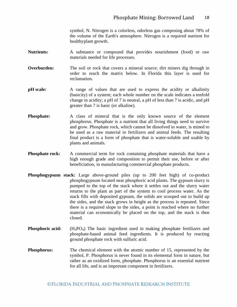
Phosphate Mining: Borrowed Land 18
FLORIDA INDUSTRIAL AND PHOSPHATE RESEARCH INSTITUTE
symbol, N. Nitrogen is a colorless, odorless gas composing about 78% of
the volume of the Earth's atmosphere. Nitrogen is a required nutrient for
healthy plant growth.
Nutrients: A substance or compound that provides nourishment (food) or raw
materials needed for life processes.
Overburden: The soil or rock that covers a mineral source; dirt miners dig through in
order to reach the matrix below. In Florida this layer is used for
reclamation.
pH scale: A range of values that are used to express the acidity or alkalinity
(basicity) of a system; each whole number on the scale indicates a tenfold
change in acidity; a pH of 7 is neutral, a pH of less than 7 is acidic, and pH
greater than 7 is basic (or alkaline).
Phosphate: A class of mineral that is the only known source of the element
phosphorus. Phosphate is a nutrient that all living things need to survive
and grow. Phosphate rock, which cannot be dissolved in water, is mined to
be used as a raw material in fertilizers and animal feeds. The resulting
final product is a form of phosphate that is water-soluble and usable by
plants and animals.
Phosphate rock: A commercial term for rock containing phosphate materials that have a
high enough grade and composition to permit their use, before or after
beneficiation, in manufacturing commercial phosphate products.
Phosphogypsum stack: Large above-ground piles (up to 200 feet high) of co-product
phosphogypsum located near phosphoric acid plants. The gypsum slurry is
pumped to the top of the stack where it settles out and the slurry water
returns to the plant as part of the system to cool process water. As the
stack fills with deposited gypsum, the solids are scooped out to build up
the sides, and the stack grows in height as the process is repeated. Since
there is a required slope to the sides, a point is reached where no further
material can economically be placed on the top, and the stack is then
closed.
Phosphoric acid: (H3PO4) The basic ingredient used in making phosphate fertilizers and
phosphate-based animal feed ingredients. It is produced by reacting
ground phosphate rock with sulfuric acid.
Phosphorus: The chemical element with the atomic number of 15, represented by the
symbol, P. Phosphorus is never found in its elemental form in nature, but
rather as an oxidized form, phosphate. Phosphorus is an essential nutrient
for all life, and is an important component in fertilizers.

Phosphate Mining: Borrowed Land 19
FLORIDA INDUSTRIAL AND PHOSPHATE RESEARCH INSTITUTE
Photosynthesis: A chemical process by which plants use light energy to convert carbon
dioxide and water into carbohydrates (sugars).
Plant density: A quantitative measure of the plant cover on an area, i.e., the amount of
plant material per unit area or space.
Plastron: The bottom shell of an organism; for example a turtle or tortoise.
Recipient site: A habitat or location to which organisms are moved from their original or
donor site; for example, the gopher tortoise.
Reclamation: The process of rehabilitating lands disturbed by mining so that they serve
a desirable and useful purpose, the result of which may or may not be
returning the land to its original uses and functions.
Refuge: A place where a living organism can survive extreme stressors such as
drought, flood, freezing weather or fire. The refuge offers localized
protection from adverse conditions.
Scute: The horny skin plates or scales over an organism's bony shell; for
example, a gopher tortoise.
Shrub: A woody plant of relatively low height, having several stems rising from
the base and lacking a single trunk; a bush.
Slurry: A semi-fluid mixture of a liquid (usually water) and insoluble solid
particles such as clays, phosphogypsum or sand.
Sulfur: The chemical element with the atomic number of 16, represented by the
symbol, S. Sulfur is a bright yellow, crystalline solid at room temperature.
In phosphate fertilizer production, elemental sulfur is used to produce
sulfuric acid, used to digest the phosphate rock in the formation of
phosphoric acid.
Sulfuric acid: A strong mineral acid, notated as H2SO4, made by burning molten sulfur
in the presence of air, followed by hydration. Sulfuric acid is highly
corrosive, especially on reactive metals. In phosphate fertilizer production,
the generation of sulfuric acid is the first industrial step, as it subsequently
used to digest (or dissolve) the phosphate rock to form phosphoric acid
and phosphogypsum in a replacement reaction.
Swamp: A piece of wet, spongy land that is permanently or periodically covered
with water, characterized by growths of shrubs and trees.
Symbiosis: A relationship in which two different organisms live in close association
with each other.

Phosphate Mining: Borrowed Land 20
FLORIDA INDUSTRIAL AND PHOSPHATE RESEARCH INSTITUTE
Take: A regulatory agency term for the illegal act of killing a protected species
or interfering with the animal’s nest or burrow.
Transects: In the context of sampling natural populations, a line drawn across the
region of interest. Sampling may consist of examining the occurrence of
organisms along the line, or visible from the line or within a sequence of
quadrants centered on the line.
Tree canopy: The upper reaches of a tree; the leaf crown. Responsible for the shade
footprint of the tree.
Uplands: The wide category of Florida habitat types that are not considered
wetlands. Includes pine flatwoods, dry prairies, scrub, coastal strands,
beach dunes, hardwood and palm hammocks, sandhills, and pine
rocklands.
Upper respiratory tract disease (URTD): The illness affecting gopher tortoises caused by a
bacterium, Mycoplasma agassizii. It is transmissible between tortoises,
resulting in sickness or death. There is no known cure.
Upwelling: A process in which cold, often nutrient-rich waters from the ocean depths
rise to the surface. In the Miocene Epoch, upwelling contributed to the
formation of phosphate.
Vegetation assessment: A method or methods of quantifying or qualifying the plants growing in
a given area.
Vertebrate: Any of a large group of chordates of the subphylum Vertebrata (or
Craniata), characterized by having a backbone. Vertebrates include fish,
amphibians, reptiles, birds, and mammals.
Wetlands: An area that is saturated by surface or ground water with vegetation
adapted for life under those soil conditions, such as swamps, bogs, fens,
marshes, and estuaries.
Xeric hammock: Areas where soils are dry and contain ample oxygen to meet plant needs. Rain
water drains rapidly from xeric soils. Oaks and hickory are abundant in this
habitat, which has a wide diversity of animal species such as squirrels, wild
turkey and hogs, deer, toads, snakes, owls, opossums, and armadillos.
Phosphate Mining: Borrowed Land 21
FLORIDA INDUSTRIAL AND PHOSPHATE RESEARCH INSTITUTE
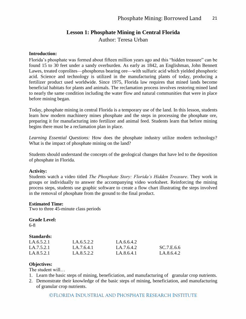
Lesson 1: Phosphate Mining in Central Florida
Author: Teresa Urban
Introduction:
Florida’s phosphate was formed about fifteen million years ago and this “hidden treasure” can be
found 15 to 30 feet under a sandy overburden. As early as 1842, an Englishman, John Bennett
Lawes, treated coprolites—phosphorus bearing ore—with sulfuric acid which yielded phosphoric
acid. Science and technology is utilized in the manufacturing plants of today, producing a
fertilizer product used worldwide. Since 1975, Florida law requires that mined lands become
beneficial habitats for plants and animals. The reclamation process involves restoring mined land
to nearly the same condition including the water flow and natural communities that were in place
before mining began.
Today, phosphate mining in central Florida is a temporary use of the land. In this lesson, students
learn how modern machinery mines phosphate and the steps in processing the phosphate ore,
preparing it for manufacturing into fertilizer and animal feed. Students learn that before mining
begins there must be a reclamation plan in place.
Learning Essential Questions: How does the phosphate industry utilize modern technology?
What is the impact of phosphate mining on the land?
Students should understand the concepts of the geological changes that have led to the deposition
of phosphate in Florida.
Activity:
Students watch a video titled The Phosphate Story: Florida’s Hidden Treasure. They work in
groups or individually to answer the accompanying video worksheet. Reinforcing the mining
process steps, students use graphic software to create a flow chart illustrating the steps involved
in the removal of phosphate from the ground to the final product.
Estimated Time: Two to three 45-minute class periods
Grade Level:
6-8
Standards:
LA.6.5.2.1 LA.6.5.2.2 LA.6.6.4.2
LA.7.5.2.1 LA.7.6.4.1 LA.7.6.4.2 SC.7.E.6.6
LA.8.5.2.1 LA.8.5.2.2 LA.8.6.4.1 LA.8.6.4.2
Objectives:
The student will…
1. Learn the basic steps of mining, beneficiation, and manufacturing of granular crop nutrients.
2. Demonstrate their knowledge of the basic steps of mining, beneficiation, and manufacturing
of granular crop nutrients.
Phosphate Mining: Borrowed Land 22
FLORIDA INDUSTRIAL AND PHOSPHATE RESEARCH INSTITUTE
Vocabulary:
phosphate overburden
matrix slurry
beneficiation reclamation
sulfur sulfuric acid
granulation phosphoric acid
ammonia gypsum
phosphate rock fertilizer
phosphogypsum stack
Materials: Computer lab with LCD projector for demonstrating the assignment DVD—The Phosphate Story: Florida’s Hidden Treasure (can borrow from FIPR Institute 863-
534-7160) DVD player or computer that plays DVDs with LCD projector The Phosphate Story: Florida’s Hidden Treasure DVD worksheet Copies of the diagram checklists Procedure: Day 1 1. Before viewing the video The Phosphate Story: Florida’s Hidden Treasure, point out to the
students that large amounts of phosphate rock must first be processed in order to be made into the final product, fertilizer.
2. Distribute the worksheet with questions from the video. Instruct the students that all of the answers will be found throughout the video. The video can be paused after each of the three sections to allow students to finish the worksheet in increments. Guide the completion of worksheet as desired.
3. While watching the video point out key steps in the mining process that they will illustrate later. (Key steps - Day 2.) After the video, mention that all phosphate mined in Florida is now processed in Florida only, not also in Louisiana.
Day 2 1. Schedule a computer lab for the day after viewing the video. Computers should have
graphical software such as Inspiration (recommended) or Microsoft Office Word where students can design flow charts, timelines, or other similar illustrations.
2. In the computer lab, demonstrate how to make a flow chart. Use the software’s graphical clip art and symbols for the arrows and illustrations. Students may use their worksheets and checklist sheets while they create their flow charts.
3. Print diagrams for display or save to be included in students’ electronic portfolios or project folios. Have students use the checklist to evaluate their own diagrams.
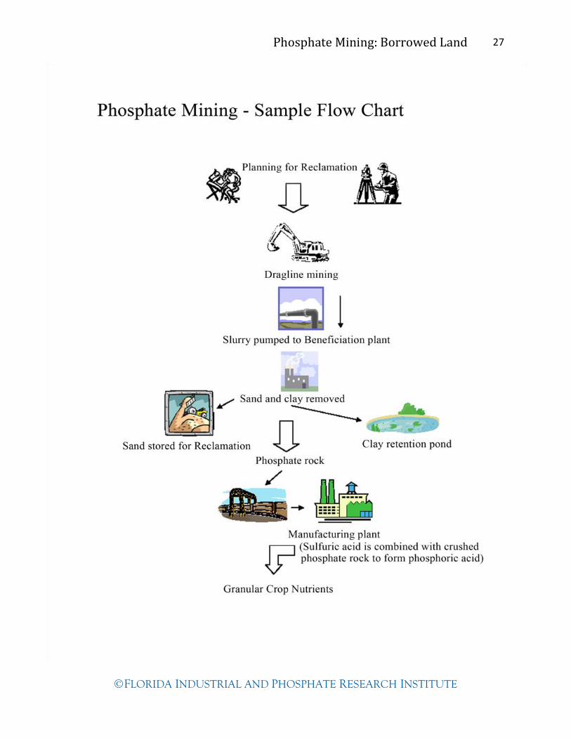
List of key steps in phosphate mining process:
Planning for reclamation Dragline mining Transportation of ore (slurry pumped through pipeline) Beneficiation plant for removing clay and sand from slurry Transportation of phosphate rock to manufacturing plant Production of sulfuric acid Production of phosphoric acid Production of granular crop nutrients

Phosphate Mining: Borrowed Land 23
FLORIDA INDUSTRIAL AND PHOSPHATE RESEARCH INSTITUTE
Analysis/Conclusion: Use checklist for assessing the computer assignment. Use these discussion questions to assess student learning.
1. Name all the examples of modern technology that you see in the video. 2. Name and describe the jobs of the people in the video. 3. How do you think the land is put back to usefulness after mining is completed? 4. List the raw products needed in order to produce fertilizer. 5. What must be done to the phosphate rock before it is sent to the manufacturing plant?
Extension:
Kids Dig It! Part 1 and Kids Dig It! Part 2 kits, available at FIPR Institute, are great for building
on the geology background knowledge.
Students may research online to find out how much fertilizer product is made each year. They
may research to find other economic factors that affect Florida’s economy.
Students may research earlier techniques used to mine phosphate in central Florida. Compare
them to today’s mining and processing techniques.
Teacher Notes: Borrow the DVD—The Phosphate Story: Florida’s Hidden Treasure from FIPR Institute— 863-534-7160 Make copies of the video questions worksheet (1 per student)
Make copies of the checklist for the students’ diagrams

Phosphate Mining: Borrowed Land 24
FLORIDA INDUSTRIAL AND PHOSPHATE RESEARCH INSTITUTE
The Phosphate Story: Florida’s Hidden Treasure
Part 1: Mining for Phosphate Rock
1. In the video, phosphate is referred to as ___________ ____________.
2. The soil on top of the phosphate deposit is called _____________________.
3. While digging, a dragline operator can tell where the phosphate is located by the
____________________.
4. A dragline operates on what source of power? ___________________
5. The mechanical feet of a dragline move it a little faster than the speed of the
______________ _______________ when it is being rolled to the launch site.
6. One dragline bucket can hold up to ________ tons.
7. The mixture of sand, clay, and phosphate rock is called ___________________.
8. Describe how phosphate rock, sand and clay are moved from the mine site to the
beneficiation plant where the mixture is separated.
9. What happens to the clay after it is separated from the mixture?
10. When the sand is removed from the mixture, how does the industry use it?
11. How much of the water used in the beneficiation process is recycled? __________
12. What happens to the phosphate rock (pebbles) after the clay and sand are separated?

Phosphate Mining: Borrowed Land 25
FLORIDA INDUSTRIAL AND PHOSPHATE RESEARCH INSTITUTE
Part 2: Manufacturing Crop Nutrients
13. The raw material, ______________, is mixed with air to produce sulfuric acid.
14. Steam from the sulfuric acid plant is used to generate ______________________.
15. The raw material, ______________ __________ is transported by rail from the
beneficiation plant to the crop nutrient manufacturing plant.
16. Phosphate rock must be ____________ into a fine ___________ before it can be reacted
with the sulfuric acid to make phosphoric acid.
17. Why must the co-product phosphogypsum be continually stacked rather than used for road
beds or other products?
18. What do the manufacturing companies do to protect the ground water underneath the gypsum
stacks?
Part 3: Reclaiming the Land
19. Before the land is mined for the phosphate, what must the experts do?
20. Land that has been mined must be reclaimed for useful purposes. List some of these uses.

Phosphate Mining: Borrowed Land 26
FLORIDA INDUSTRIAL AND PHOSPHATE RESEARCH INSTITUTE
The Phosphate Story: Florida’s Hidden Treasure
Answer Key
1. In the video, phosphate is referred to as gray gold.
2. The soil on top of the phosphate deposit is called overburden.
3. While digging, a dragline operator can tell where the phosphate is located by the color.
4. A dragline operates on what source of power? electricity
5. The mechanical feet of a dragline move it a little faster than the speed of the space shuttle when
it is being rolled to the launch site.
6. A dragline bucket can hold up to 65 tons of earth.
7. The mixture of sand, clay, and phosphate rock is called matrix.
8. Describe how phosphate rock, sand and clay are moved from the mine site to the beneficiation
plant where the mixture is separated. The buckets of matrix are dumped into a pit (or well)
where high powered water guns are used to break up the large clumps of matrix to make a
slurry. The slurry is then pumped through pipes to a beneficiation plant. 9. What happens to the clay after it is separated from the mixture? The clay water is pumped to
clay-settling ponds. 10. When the sand is removed from the mixture, how does the industry use it? The sand is shipped
back to the mine site to be used during reclamation. 11. How much of the water used in the beneficiation process is recycled? 98%
12. What happens to the phosphate rock (pebbles) after the clay and sand are separated? The
phosphate is transported by railcar to the manufacturing plants. 13. The raw material, sulfur, is mixed with air to produce sulfuric acid.
14. Steam from the sulfuric acid plant is used to generate electricity.
15. The raw material, phosphate rock is transported by rail from the beneficiation plant to the crop
nutrient manufacturing plant.
16. Phosphate rock must be crushed into a fine powder before it can be reacted with the sulfuric
acid to make phosphoric acid.
17. Why must the co-product phosphogypsum be continually stacked rather than used for road beds
or other products? The phosphogypsum contains minute traces of radiation.
18. What do the manufacturing companies do to protect the ground water underneath the gypsum
stacks? The companies place a liner on the ground before stacking the phosphogypsum and
constantly monitor the pH of the water. 19. Before the land is mined for the phosphate, what must the experts do? Before mining begins a
mining permit and reclamation plan must be submitted. 20. Land that has been mined must be reclaimed for useful purposes. List some of these uses.
Habitats such as; wetlands, lakes, scrub lands, forests, grasslands, etc.
Housing developments
Cattle grazing land or other agricultural uses
Shopping Centers
Phosphate Mining: Borrowed Land 27
FLORIDA INDUSTRIAL AND PHOSPHATE RESEARCH INSTITUTE
Phosphate Mining: Borrowed Land 28
FLORIDA INDUSTRIAL AND PHOSPHATE RESEARCH INSTITUTE
Lesson 2: GPS Technology and Phosphate Mining
Author: Teresa Urban
Introduction:
“Florida's typical phosphate ore (matrix) is found about 15-50 feet below the earth's surface and
is about 10-20 feet thick. Draglines strip off the top layer of earth (known as overburden) to get
at the matrix, which is then processed to separate the phosphate from the sand and clay that make
up this layer of Florida.”
http://www.fipr.poly.usf.edu
Planning for a phosphate mine begins with prospecting, where overburden depth, matrix depth,
and matrix quality are determined using core samples. Typically this kind of core sample is
drilled on a 330’ grid—one core sample per 2.5 acres. Each core sample is logged, tagged and
sent to a pilot plant for further analysis. There the quality of the phosphate matrix is determined.
The data is recorded and section maps are created to serve as guides for dragline operators.
Core samples are analyzed and mapped providing a guide for dragline operators to precisely dig
phosphate deposits. GPS technology increases mining efficiency by tracking equipment and
shovel and drilling positioning. This lesson allows students to become familiar with GPS
technology and practice using GPS receivers. The activity is a simulation of a technique used by
the mining companies to efficiently find and remove phosphate ore.
Learning Essential Questions: How does a dragline operator analyze data from a sectional core
map to know where to dig for phosphate? How does the mining industry use GPS
technology to make maps of phosphate deposits?
Play Ore Body Battleship (Lesson Plan on Resource CD) to acquaint students with the
techniques used to find phosphate deposits—core drilling. Another activity from Women in
Mining, Cupcake Core Sampling, may be played before or after this lesson.
(http://www.coaleducation.org/lessons/wim/4.htm)
Students must be familiar with directional coordinates—latitude and longitude. They must be
familiar with the Garmin eTrex GPS receiver functions. Use Locating Waypoints for assistance.
Basic linear measuring skills in metrics required.
Activity:
Student teams use a GPS receiver to navigate to the core sample target. At the target site,
students remove the core sample. They measure and record the layers of earth; limestone, matrix
(phosphate deposit), and overburden. After completing the chart by measuring all six bottles—
they return to the classroom where they will draw a sectional core sample map of the layers of
earth.
Estimated Time:
One 45-minute class period
Grade Level:
6-8
Phosphate Mining: Borrowed Land 29
FLORIDA INDUSTRIAL AND PHOSPHATE RESEARCH INSTITUTE
Standards:
SS.6.G.1.1 SS.6.G.1.3 SS.6.G.1.4
MA.7.A.1.1 SC.7.N.1.1
Objectives:
The students will …
1. Use a GPS receiver to locate given waypoints on school grounds—the locations of core
samples.
2. Record data measurements from each core sample.
3. Using the data collected they will draw a sectional phosphate ore location map.
4. Analyze their drawings to determine the approximate depth of the simulated phosphate
deposit.
Vocabulary: latitude longitude
core sample matrix
Geologist overburden
GPS (Global Positioning System)
Materials:
Set of GPS receivers available for check-out at FIPR Institute (1 per group of 2-6)
Have extra AA batteries on hand
Guide for Location Waypoints Using Garmin eTrex Receivers
Centimeter grid paper (1 per student, used in classroom)
Pencils
Clipboards
Core Sample Data Chart worksheet (per group/team’s field work)
Meter stick to measure distance between waypoints (approximately 5-8 meters between
waypoints)
5 clear plastic 16 oz. water bottles for core samples
Centimeter ruler for each team
Play sand
Aquarium gravel
Topsoil or potting soil
Funnel
Newspapers
Small hand spade
Procedure:
1. Explain to students that before phosphate is mined the land must be prospected. Explain how
geologists and technicians drill core samples in order to analyze the layers of earth.
2. Next, explain the directions that they as teams will follow to locate the core samples. If
necessary, review GPS receiver Locating Waypoints.
3. After team assignments, tell students to head to the first waypoint core sample target. Pull
the sample (water bottle) from the ground at the waypoint. Measure, in centimeters, each
layer starting from the bottom of the bottle. Record the depth of each layer on the Core
Sample Data Chart. (Have the students rebury the core sample for the next group, if using
the same for all groups.)
Phosphate Mining: Borrowed Land 30
FLORIDA INDUSTRIAL AND PHOSPHATE RESEARCH INSTITUTE
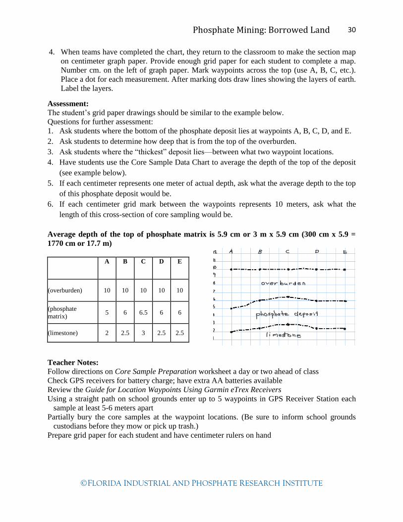
4. When teams have completed the chart, they return to the classroom to make the section map
on centimeter graph paper. Provide enough grid paper for each student to complete a map.
Number cm. on the left of graph paper. Mark waypoints across the top (use A, B, C, etc.).
Place a dot for each measurement. After marking dots draw lines showing the layers of earth.
Label the layers.
Assessment:
The student’s grid paper drawings should be similar to the example below.
Questions for further assessment:
1. Ask students where the bottom of the phosphate deposit lies at waypoints A, B, C, D, and E.
2. Ask students to determine how deep that is from the top of the overburden.
3. Ask students where the “thickest” deposit lies—between what two waypoint locations.
4. Have students use the Core Sample Data Chart to average the depth of the top of the deposit
(see example below).
5. If each centimeter represents one meter of actual depth, ask what the average depth to the top
of this phosphate deposit would be.
6. If each centimeter grid mark between the waypoints represents 10 meters, ask what the
length of this cross-section of core sampling would be.
Average depth of the top of phosphate matrix is 5.9 cm or 3 m x 5.9 cm (300 cm x 5.9 =
1770 cm or 17.7 m)
A B C D E
(overburden) 10 10 10 10 10
(phosphate
matrix) 5 6 6.5 6 6
(limestone) 2 2.5 3 2.5 2.5
Teacher Notes:
Follow directions on Core Sample Preparation worksheet a day or two ahead of class
Check GPS receivers for battery charge; have extra AA batteries available
Review the Guide for Location Waypoints Using Garmin eTrex Receivers
Using a straight path on school grounds enter up to 5 waypoints in GPS Receiver Station each
sample at least 5-6 meters apart
Partially bury the core samples at the waypoint locations. (Be sure to inform school grounds
custodians before they mow or pick up trash.)
Prepare grid paper for each student and have centimeter rulers on hand

Phosphate Mining: Borrowed Land 31
FLORIDA INDUSTRIAL AND PHOSPHATE RESEARCH INSTITUTE
Core Sample Preparation (Teacher Instructions)
For each team, fill up to 5 clear plastic 16 oz. water bottles with three different materials that
indicate limestone bedrock, phosphate matrix and overburden /soil.
1. Label each bottle A, B, C, D, or E.
2. Use sand for the limestone layer measuring around 2-3 centimeters from the bottom of bottle.
3. Use aquarium gravel for the phosphate matrix layer measuring around 4-6 centimeters from
the top of the sand—colored gravel would work well.
4. Use topsoil or potting soil to represent the overburden. This layer could measure all the way
to the same level on each bottle, about 15 centimeters from the bottom of bottle.
5. Measure and record the levels for answer key.
6. Partially bury core samples in the ground at each waypoint—going in a straight line about 5-
8 meters apart.
SOIL
PEBBLES
SAND
cen
tim
eter
s
Phosphate Mining: Borrowed Land 32
FLORIDA INDUSTRIAL AND PHOSPHATE RESEARCH INSTITUTE
Guide for Locating Waypoints
Using Garmin eTrex Receivers
(adapted from eTrex Manual)
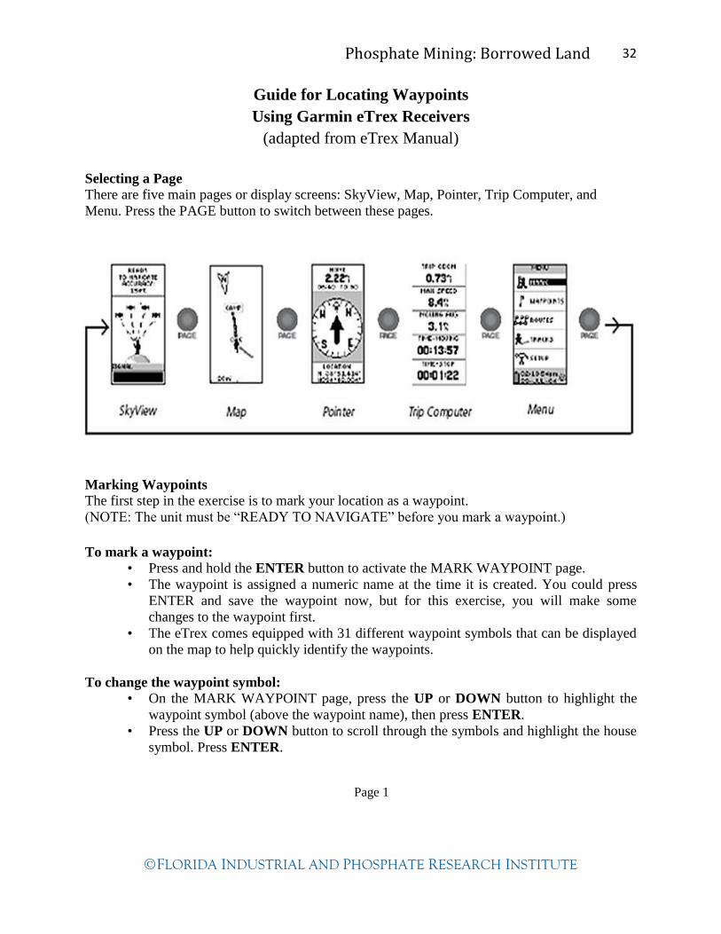
Selecting a Page
There are five main pages or display screens: SkyView, Map, Pointer, Trip Computer, and
Menu. Press the PAGE button to switch between these pages.
Marking Waypoints
The first step in the exercise is to mark your location as a waypoint.
(NOTE: The unit must be “READY TO NAVIGATE” before you mark a waypoint.)
To mark a waypoint:
• Press and hold the ENTER button to activate the MARK WAYPOINT page.
• The waypoint is assigned a numeric name at the time it is created. You could press
ENTER and save the waypoint now, but for this exercise, you will make some
changes to the waypoint first.
• The eTrex comes equipped with 31 different waypoint symbols that can be displayed
on the map to help quickly identify the waypoints.
To change the waypoint symbol:
• On the MARK WAYPOINT page, press the UP or DOWN button to highlight the
waypoint symbol (above the waypoint name), then press ENTER.
• Press the UP or DOWN button to scroll through the symbols and highlight the house
symbol. Press ENTER.
Page 1
Phosphate Mining: Borrowed Land 33
FLORIDA INDUSTRIAL AND PHOSPHATE RESEARCH INSTITUTE
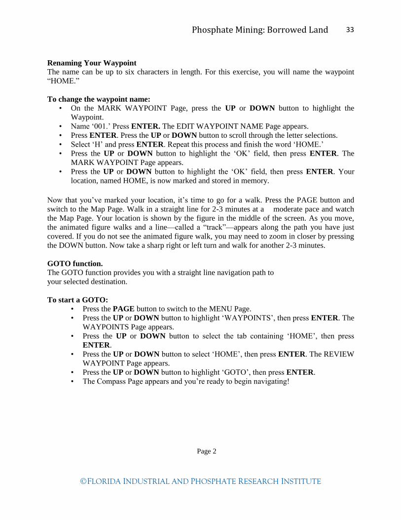
Renaming Your Waypoint
The name can be up to six characters in length. For this exercise, you will name the waypoint
“HOME.”
To change the waypoint name:
• On the MARK WAYPOINT Page, press the UP or DOWN button to highlight the
Waypoint.
• Name ‘001.’ Press ENTER. The EDIT WAYPOINT NAME Page appears.
• Press ENTER. Press the UP or DOWN button to scroll through the letter selections.
• Select ‘H’ and press ENTER. Repeat this process and finish the word ‘HOME.’
• Press the UP or DOWN button to highlight the ‘OK’ field, then press ENTER. The
MARK WAYPOINT Page appears.
• Press the UP or DOWN button to highlight the ‘OK’ field, then press ENTER. Your
location, named HOME, is now marked and stored in memory.
Now that you’ve marked your location, it’s time to go for a walk. Press the PAGE button and
switch to the Map Page. Walk in a straight line for 2-3 minutes at a moderate pace and watch
the Map Page. Your location is shown by the figure in the middle of the screen. As you move,
the animated figure walks and a line—called a “track”—appears along the path you have just
covered. If you do not see the animated figure walk, you may need to zoom in closer by pressing
the DOWN button. Now take a sharp right or left turn and walk for another 2-3 minutes.
Getting Started
GOTO function. The GOTO function provides you with a straight line navigation path to
your selected destination.
To start a GOTO:
• Press the PAGE button to switch to the MENU Page.
• Press the UP or DOWN button to highlight ‘WAYPOINTS’, then press ENTER. The
WAYPOINTS Page appears.
• Press the UP or DOWN button to select the tab containing ‘HOME’, then press
ENTER.
• Press the UP or DOWN button to select ‘HOME’, then press ENTER. The REVIEW
WAYPOINT Page appears.
• Press the UP or DOWN button to highlight ‘GOTO’, then press ENTER.
• The Compass Page appears and you’re ready to begin navigating!
Page 2

Phosphate Mining: Borrowed Land 34
FLORIDA INDUSTRIAL AND PHOSPHATE RESEARCH INSTITUTE
Core Sample Data Chart
Waypoint A Lat.________ Long.______
Waypoint B Lat.________ Long.______
Waypoint C Lat.________ Long.______
Waypoint D Lat.________ Long.______
Waypoint E Lat.________ Long._______
Measure the
height of the
“overburden”
layer in cm.
(soil)
Measure the
height of the
“phosphate
matrix”
layer in cm.
(gravel)
Measure the
height of the
“limestone”
layer in cm.
(sand)
Core sample instructions:
1. Record the latitude and longitude where the core sample was found.
2. Measure, in centimeters, from the bottom of the bottle to the top of the “limestone” layer
(sand) and record the depth in the corresponding box.
3. Measure from the top of the “limestone” layer (sand) up to the top of the “phosphate matrix”
layer (gravel) and record the depth in the corresponding box.
4. Measure from the “phosphate matrix” layer (gravel) up to the top of the “overburden” layer
(soil) and record the depth in the corresponding box.
5. Make sure to measure and record the depths for each core sample in order.
Step 4
Step 3
Step 2

Phosphate Mining: Borrowed Land 35
FLORIDA INDUSTRIAL AND PHOSPHATE RESEARCH INSTITUTE
Lesson 3: Phosphorus Cycle
Author: Teresa Urban
Introduction:
“Phosphorus is in nature, always combined with other elements, most commonly with calcium,
hydrogen, oxygen, and fluorine. Other elements found in smaller amounts include iron,
aluminum, and even uranium.” (Ray Driver: FIPR Workshop, 9-11-99) Atoms like carbon,
nitrogen, phosphorus, and other elements contained in living organisms today are the same atoms
that have been on Earth since its beginning. They are constantly being recycled. The phosphorus
cycle is the slowest of all the matter cycles. Unlike the other matter cycles, phosphorus cycles
through water, soil and sediment, not air. Phosphorus is primarily found in rock formations and
ocean sediment as phosphate salt. These phosphate salts dissolve in soil water allowing plants to
absorb them. However, the quantity of phosphorus in soil is low so farmers apply phosphate in
the form of fertilizer to their crops. Phosphorus is an essential nutrient for plants and animals. It
is part of DNA molecules that store energy (ATP and ADP), the fats in cell membranes, and are
present in both animal and human bones and teeth. Phosphorus cycles faster through plants and
animals than through soil and rock. Phosphates return to the soil and ocean sediments when
plants and animals die and decay. Eventually these sediments become part of the rock cycle
where phosphorus may be stored for millions of years. http://www.lenntech.com/phosphorus-
cycle.htm
Phosphate is an essential mineral that all living things need to survive and grow. This lesson
makes a connection between the natural recycling of nutrient matter—including phosphorus—on
the earth to the formation of phosphate deposits in Florida.
Essential Question: How does matter, like phosphorus, cycle in nature?
How is phosphate formed?
Matter, in the form of nutrients, moves through ecosystems, but cannot be replaced like energy
from the sun. Nutrients enter the water through a variety of sources and are part of the larger
food chain. Vertebrates, invertebrates and microorganisms all contribute to the formation of
phosphate by simply living and dying. The remains and activities of vertebrates and invertebrates
contribute to “phosphate deposition.” Marine vertebrates shed teeth and produce coprolites
(pieces of fossilized excrement/animal waste) during their lifetime. When they die and
decompose the skeletal remains enter the nutrient cycle. Invertebrates contribute to this cycle.
Crabs and shrimp carcasses contain high levels of phosphate though their remains are rarely
fossilized in Florida. Mollusks may have excreted phosphate particles. Worm-like animals may
have excreted phosphate particles in response to an irritant in the digestive process.
Microorganisms process the waste on the ocean floor and release phosphate and other nutrients.
Changing sea levels and upwelling of ocean waters, caused by cold and warm water currents,
churned up this nutrient-rich water over the hills, trapping it in the basins of the limestone
foundation of Florida. The continued food chain in the oceans, upwelling and sea level changes
brought about an accumulation of phosphate-enriched sediments over the limestone bedrock,
thus forming the phosphate deposits in central Florida.
Phosphate Mining: Borrowed Land 36
FLORIDA INDUSTRIAL AND PHOSPHATE RESEARCH INSTITUTE
A source on the formation of phosphate is an article by Stanley R. Riggs, Petrology of the
Tertiary Phosphate System of Florida, found in Economic Geology, Volume 74.
Students should be familiar with the geological history of Florida. Students need to have a basic
knowledge of the structure of matter—atoms, molecules, compounds, etc. They should also be
familiar with the basic functions of word processing and drawing applications.
Activity: The water, carbon, nitrogen and phosphorus cycles are presented through a teacher guided
PowerPoint. Students learn about the phosphorus cycle and its relation to the central Florida
phosphate deposition and then generate an electronic illustration depicting the cycling of
phosphorus on earth and showing the connection to the mining of Florida phosphate deposits.
Estimated Time: Two to three 45-minute class periods
Grade Level:
6-8
Standards:
LA.6.5.2.1 LA.6.5.2.2 LA.6.6.4.2
LA.7.5.2.1 LA.7.6.4.2 SC.7.E.6.2 SC.7.L.17.1
LA.8.5.2.2 LA.8.6.4.1 LA.8.6.4.2 SC.8.L.18.3 SC.8.L.18.4 Objectives: The students will…
1. Gain knowledge about the phosphorus cycle and development of phosphate deposits in
central Florida.
2. Apply their knowledge of the phosphorus cycle to generate an electronic graphical drawing.
Vocabulary:
atom carbon dioxide
fossil fuels invertebrates
matter molecule
microorganism nitrogen
nutrients phosphate
phosphorus upwelling
vertebrates symbiosis
Materials: Computer with internet connection and LCD projector PowerPoint Cycles of Matter on Earth located on the Resource CD from FIPR Institute Computer lab Paper and pencil for computer-based research Handout of checklist for phosphorus cycle drawing Procedure:
1. Use the Cycles of Matter on Earth PowerPoint notes pages to aid in explaining each slide.
Phosphate Mining: Borrowed Land 37
FLORIDA INDUSTRIAL AND PHOSPHATE RESEARCH INSTITUTE
2. Click on the star on slide #4 to play the Carbon Cycle Game for an optional learning activity.
3. There is a link to an online phosphorus cycle animation with audio that is suitable for middle
school students.
(http://www.wadsworthmedia.com/biology/starr_udl11_tour/phos_anim.html)
4. After the presentation explain to students that they will generate a phosphorus cycle using
the computer (Microsoft Office Word, Inspiration or other suitable drawing software).
5. Hand out the phosphorus cycle checklists for the next day’s assignment in the computer lab.
Students may use the internet at home to review the phosphorus cycle. Most software
contains a variety of clipart to make a flowchart-type drawing of the cycle. Include these
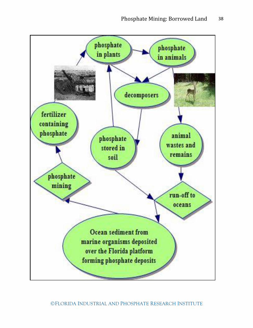
labels in your phosphorus cycle drawing:
• the ocean sediment and deposition of phosphate on the Florida platform
• phosphate mining
• fertilizer applied to crops
• absorption by plants
• animals eating plants
• excrement from animals
• decomposers
• phosphate stored in soil
• run-off going to lakes, rivers or oceans
Analysis/Conclusion:
Use the phosphorus cycle checklist to assess the drawing of the phosphorus cycle. An example,
created in Inspiration software, is on the next page.
Additional questions for assessing student learning are:
1. Why is phosphorus an essential element for plants and animals? It is part of their DNA and
the building blocks of bones and teeth. 2. Where would you find phosphorus on earth? It is found in rock, soil, sediment and water.
3. How does phosphorus move between soil and plants? Plant roots absorb phosphorus in
the form of phosphates. 4. How does phosphorus enter bodies of water? It is washed away from the soil and animal
waste and from the food chains in water.
Teacher Notes:
Print a copy of the Cycles of Matter on Earth PowerPoint notes
Set up class time in the computer lab
Make copies of the Phosphate Cycle Drawing Checklist for each student
Phosphate Mining: Borrowed Land 38
FLORIDA INDUSTRIAL AND PHOSPHATE RESEARCH INSTITUTE

Phosphate Mining: Borrowed Land 39
FLORIDA INDUSTRIAL AND PHOSPHATE RESEARCH INSTITUTE
Name ______________________________________________________
Phosphorus Cycle Drawing Checklist
Are the following key steps included in the diagram?
Phosphates in…
____ the ocean sediment and deposition of phosphate on the Florida platform
____ phosphate mining
____ fertilizer applied to crops
____ absorption by plants
____ animals eating plants
____ excrement from animals
____ decomposers
____ phosphate stored in soil
____ run-off going to lakes, rivers or oceans
Are each of these steps illustrated or emphasized in some way?
Are there arrows making connections to each level of the phosphorus cycle?

Phosphate Mining: Borrowed Land 40
FLORIDA INDUSTRIAL AND PHOSPHATE RESEARCH INSTITUTE
Lesson 4: Natural Communities of Central Florida
Author: Teresa Urban
Introduction:
Ecosystems are made up of the living and the non-living things in a particular place. Each part of
an ecosystem is important, because all of the parts must work together if the system is to survive.
Since the mining process is conducted in many types of ecosystems, reclamation plans are
custom-made for each mine site.
Ecologists have not always agreed on the best ways to classify Florida’s ecosystems. The most
widely used approach is to classify the natural vegetation. There are over 80 documented natural
communities in the state of Florida. The focus here is on the general plant communities of central
Florida (Peace River, Alafia River, and Hillsborough River Basins).
Generally Florida is flat. There is an imperceptible change in elevation. However, as little as a
few inches can result in changes in plant composition or natural communities. The Lakeland
Ridge and Lake Wales Ridge offer rich upland and scrub-type habitats. Nestled between the
ridges and rivers are the flatwoods, dry and wet prairies, basin swamps, basin marshes, ponds
and lakes. The lowlands provide freshwater marshes, bay heads, and floodplain hardwood
forests.
Students realize that Florida and its habitats and wildlife have evolved and changed. They
understand that in order for phosphate mining companies to reclaim land, they must first
understand the soils, natural communities, and hydrology of the land before it is mined.
Essential Questions: What are the characteristics of two natural plant communities in central
Florida?
Students must understand that an ecosystem may include both living and nonliving things.
Students should know the difference between grasses, shrubs, and trees. Students should
understand why we take pH readings to determine acidity and alkalinity of soil.
Activity:
Students take a field trip to two nearby natural vegetation sites. Teams of students collect
information about the site and record their results. Students participate in a field trip follow-up
discussion and compilation of information gathered at the sites.
Estimated time:
Four to five 45-minute class periods
One field trip day
Upland Wetlands
Dry prairies Pine flatwoods
Sand pine scrub
Sandhill Xeric oak hammock
Mixed hardwood pine forests
Hardwood hammocks
Marsh and wet prairie Cypress swamp
Hardwood swamp
Bay swamp Shrub swamp

Phosphate Mining: Borrowed Land 41
FLORIDA INDUSTRIAL AND PHOSPHATE RESEARCH INSTITUTE
Grade Level:
6-8
Standards:
LA.6.3.5.2 LA.6.4.2.2 LA.6.5.2.2 LA.6.6.4.2
LA.7.3.5.2 LA.7.4.2.2 LA.7.5.2.1 LA.7.6.4.1 LA.7.6.4.2
SC.7.E.6.6 SC.7.L.17.1 SC.7.L.17.2 SC.7.L.17.3
LA.8.3.5.2 LA.8.4.2.2 LA.8.5.2.2 LA.8.6.4.1 LA.8.6.4.2
Objectives:
The students will…
1. Recognize biotic and abiotic factors in a natural plant community.
2. Observe and note the unique characteristics of natural plant communities.
3. Compare and contrast two different natural plant communities.
4. Describe the impact that human action has had on nearby natural plant communities.
Vocabulary:
plant density tree canopy swamp natural community
marsh wetlands shrub biotic
abiotic dichotomous key pH scale acidic
basicity hydric hammock mesic hammock vegetation assessment
xeric hammock controlled burn photosynthesis
Materials:
Copies of Central Florida Oak—Dichotomous Key and Key to Common Florida Pine Trees
Copies of Natural Communities Comparison Chart
National Audubon Society: Field Guide to Florida (available for check-out at FIPR Institute)
Science probes for temperature and pH (if available)
Coffee can (both ends cut out)
Hammer
Bottles of water (same size)
Clipboards
Pencils
Weather thermometer
Glass lab thermometer (soil temp)
Soil pH meter (available at FIPR Institute)
Computers with internet connection
Microsoft Office PowerPoint or other presentation software
LCD Projector
Digital cameras
Procedure:
Day 1
Demonstrate in the schoolyard how to collect site information such as soil pH (follow directions
on box), temperature, description, soil porosity, and plant identifications using the dichotomous
keys.
Phosphate Mining: Borrowed Land 42
FLORIDA INDUSTRIAL AND PHOSPHATE RESEARCH INSTITUTE
Day 2 (Field Trip)
1. On the field trip divide students into teams with one recorder. Distribute charts with
clipboard and pencil, guides, keys, and other equipment.
2. Have groups spread out and gather the information for charts. The groups need to work in
similar plant community areas.
Day 3
1. Compile information from all the groups on large chart paper or computer with LCD
projector.
2. Distribute the Natural Communities of Central Florida Chart. Lead the discussion or have
groups determine which natural community is most like the two locations that they visited.
Class discussion questions:
a. Did you notice any differences in the types of soils at the different sites?
b. What were the primary differences in plants at each site?
c. Was there a connection to the soil and type of plants growing there?
d. What types of plants were most abundant in each site?
e. Was there any evidence of fire in the sites?
f. What would be the effect of fire on the sites?
g. How would the sites change if the trees were removed? What evidence of wildlife did
you see at the sites?
h. What kinds of wildlife would typically live there?
Day 4: 1. In the computer lab have students create a brief PowerPoint presentation showing the major
differences in the two locations visited.
2. Have the students use the digital photos taken at the site or find them online.
Analysis/Conclusion:
1. Participation on field trip—completion of Natural Community Comparison Charts by each
student or group.
2. Use the ready-made rubric to assist in evaluating the presentations.
Extension:
Have each group draw a poster illustrating the unique plants and animals of one natural
community of central Florida.
Teacher Notes:
Arrange two different field trips to nearby natural sites, school yards or parks. Arrange for two or
three chaperones per group. Most places that provide suitable field trip locations have only
one community type. See list of Polk County parks and reserve sites.
Gather and prepare field work supplies (measuring for soil porosity). Cut out both ends of a
coffee can. Make a mark about 1 inch up from the bottom. Have students clear the leaf litter
and push the can 1 inch into the ground before pouring in the water. Copy enough sheets of
the Central Florida Oak—Dichotomous Key and Key to Common Central Florida Pine Trees
for the groups assigned to gather this site information.
Copy two or three Natural Community Comparison Charts for the teams responsible for
recording the team reports.

Phosphate Mining: Borrowed Land 43
FLORIDA INDUSTRIAL AND PHOSPHATE RESEARCH INSTITUTE
Other tools and supplies: water, lab thermometer, weather thermometer, soil pH meter,
clipboards, and pencils.
Resources:
Guide to the Natural Communities of Florida. Florida Department of Natural Resources,
1990, www.fnai.org/naturalcommguide.cfm.
Rubrics can be created at:
http://rubistar.4teachers.org/
Information for possible natural community field trip locations:
http://www.polk-county.net/parks.aspx?menu_id=52
http://www.floridastateparks.org/coltcreek/default.cfm
http://www.floridastateparks.org/lakekissimmee/default.cfm
http://www.fl-dof.com/state_forests/lake_wales_ridge.html

Phosphate Mining: Borrowed Land 44
FLORIDA INDUSTRIAL AND PHOSPHATE RESEARCH INSTITUTE
Key to Common Central Florida Pine Trees
Gather pine needle clusters and pine cones from the ground. Notice that the needles are
clustered together where they attached to the limbs. These are referred to as bundles in the
dichotomous key below.
1. Needles in bundles of 3 only. Yes…go to 3
2. Needles in bundles of 2 and 3. Yes…go to 4
3. Needles are 9 to 18 inches long and cones 6 to 10 inches long. Yes…Longleaf Pine
No…go to 6
4. Needles in bundles of 2 and 3 on the same tree. Yes…Slash Pine
Needles are 5 to 10 inches long. Bark is rough. No…go to 5
5. Needles are 2 to 4 inches long. Bark is scaly. Yes…Sand Pine
6. Needles are up to 3 inches long and sometimes Yes…Loblolly Pine
twisted. Cones are 3 to 5 inches long and grayish
in color.
Example:
Bark is rough and pine needles—from the same tree— are 5 to 10 inches long in bundles of 2
and 3. The tree is a Slash Pine.
(Adapted from “Key to Common Florida Pine Trees,” The Schoolyard Wildlife Activity Guide,
Linda Cronin-Jones, Florida Game and Fresh Water Fish Commission, 1992.)

Phosphate Mining: Borrowed Land 45
FLORIDA INDUSTRIAL AND PHOSPHATE RESEARCH INSTITUTE
Central Florida Oak—Dichotomous Key
Assembled by Jeff Keene—
Hillsborough County Teacher

Phosphate Mining: Borrowed Land 46
FLORIDA INDUSTRIAL AND PHOSPHATE RESEARCH INSTITUTE
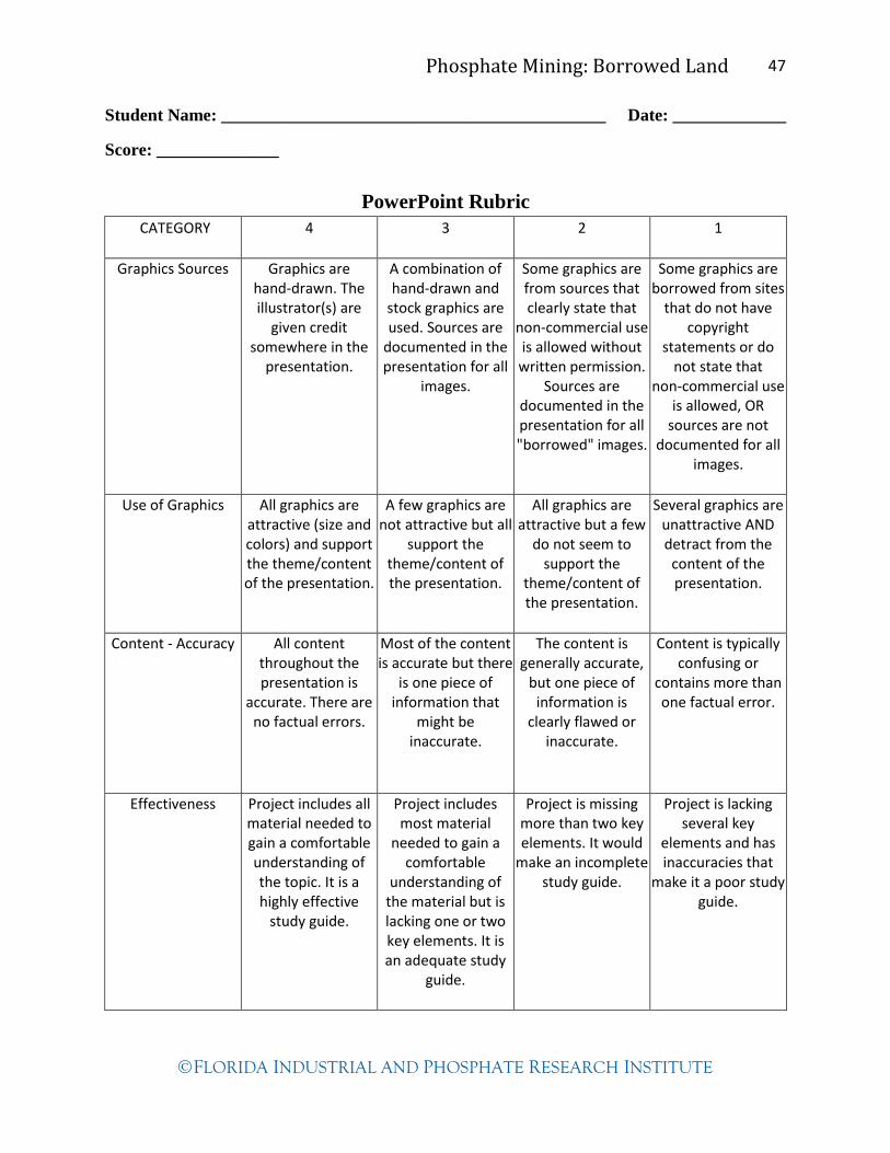
Phosphate Mining: Borrowed Land 47
FLORIDA INDUSTRIAL AND PHOSPHATE RESEARCH INSTITUTE
Student Name: ____________________________________________ Date: _____________
Score: ______________
PowerPoint Rubric
CATEGORY 4 3 2 1
Graphics Sources Graphics are hand-drawn. The illustrator(s) are
given credit somewhere in the
presentation.
A combination of hand-drawn and
stock graphics are used. Sources are
documented in the presentation for all
images.
Some graphics are from sources that clearly state that
non-commercial use is allowed without
written permission. Sources are
documented in the presentation for all "borrowed" images.
Some graphics are borrowed from sites
that do not have copyright
statements or do not state that
non-commercial use is allowed, OR
sources are not documented for all
images.
Use of Graphics All graphics are attractive (size and colors) and support the theme/content of the presentation.
A few graphics are not attractive but all
support the theme/content of the presentation.
All graphics are attractive but a few
do not seem to support the
theme/content of the presentation.
Several graphics are unattractive AND detract from the
content of the presentation.
Content - Accuracy All content throughout the presentation is
accurate. There are no factual errors.
Most of the content is accurate but there
is one piece of information that
might be inaccurate.
The content is generally accurate,
but one piece of information is
clearly flawed or inaccurate.
Content is typically confusing or
contains more than one factual error.
Effectiveness Project includes all material needed to gain a comfortable understanding of the topic. It is a highly effective
study guide.
Project includes most material
needed to gain a comfortable
understanding of the material but is lacking one or two key elements. It is an adequate study
guide.
Project is missing more than two key elements. It would
make an incomplete study guide.
Project is lacking several key
elements and has inaccuracies that
make it a poor study guide.

Phosphate Mining: Borrowed Land 48
FLORIDA INDUSTRIAL AND PHOSPHATE RESEARCH INSTITUTE
Natural Community Comparison Chart
Abiotic Characteristics Location 1 Location 2
Soil Description
(color, are there organic materials
present?)
Soil Moisture
(Does the soil hold its shape in your
hand or fall apart?)
Soil pH
(use probe if available)
Soil Porosity
(Does the water in the can disappear
quickly, slowly, or not move at all?)
Soil Temperature
(use lab type thermometer)
Air Temperature
(use weather thermometer)
Vegetation Observations
Tree Canopy Density
(estimate coverage in percentage)
Understory Density
(describe how thickly the shrubs, young
trees, and grasses are growing)
Plant Identification
Trees
(identify prominent trees—pines and
oaks)
Shrubs
Grasses
Wildflowers
Evidence of Wildlife (Scat, feathers, snake skins, owl pellets, tracks, tunnels or burrows, nests,
tree cavities, birds singing, frogs croaking, etc.)
Location 1 Location 2

Phosphate Mining: Borrowed Land 49
FLORIDA INDUSTRIAL AND PHOSPHATE RESEARCH INSTITUTE
Lesson 5: Gopher Tortoise
Author: Teresa Urban
Introduction:
Gopher tortoises, Gopherus polyphemus, in Florida are a species of special concern. The gopher
tortoise inhabits well-drained sandy soil areas, such as longleaf pine-xeric oak sandhills, scrub,
pine flatwoods, xeric hammock, dry prairie, coastal grasslands and dunes, mixed hardwood-pine
communities and a variety of disturbed habitats. Gopher tortoises excavate burrows in these
sandy soils that average 14 feet in length and six feet deep. The burrows serve as protection from
extreme temperatures, predators, and serve as refuges for approximately 360 other species. The
tolerant gopher allows many species to share the burrow either full-time or part-time. Some of
these tenants are so dependent on burrows that when the gopher tortoise disappears, they
disappear as well.* For that reason the gopher tortoise is named a “keystone species.” Examples
of animals that share the burrow are the eastern indigo snake, Florida pine snake, wolf spider,
mole skink, gopher frog, Florida mouse, southern toad, quail, burrowing owl, and black racer.
Paleontologists have discovered fossils from the Miocene Epoch that are closely related to the
modern gopher tortoise. The modern animal survived many hardships; it has endured climate
changes and other challenges. Fifty years ago mankind became the species’ worst enemy. Men
have collected the tortoises and sold them as pets; snake hunters have poured gasoline in the
burrows to flush out rattlesnakes; drivers have crushed animals on the highways. Yet the most
extreme threat man poses is destruction of the gopher tortoise’s habitat. Timber companies clear
away pine forests in which gopher tortoises made their homes. Bulldozers raze other “high and
dry” habitats, replacing burrows with houses, tourist resorts, and other commercial projects. In
1978, the Gopher Tortoise Council was established to promote research studies and determine
best practice methods of protecting the gopher tortoise and its habitats. The Florida Fish and
Wildlife Conservation Commission enforce the rules and regulations regarding the gopher
tortoise. When phosphate mining companies must clear land and tortoises are onsite, regulators
allow companies two options: mitigating for the take, by providing habitat protection elsewhere,
or relocation, whereby the company captures tortoises and releases them at another site.
Students learn that human actions—such as farming, phosphate mining and processing, building
roads, commercial and housing developments—have an impact on the environment.
Essential Question: How have mining and other human activities impacted the survival of
gopher tortoises in central Florida?
Students should understand that all animals need food, water, shelter and space to survive.
Recognize basic habitats and communities of central Florida (scrub, forested uplands, wetlands,
and sandhills). Know that tortoises are reptiles. Understand that tortoises are turtles adapted for
living on land. Understand that gopher tortoises in Florida have survived for many years—from
as early as the Miocene Epoch.
Activity:
Students watch and listen to a PowerPoint presentation giving background information about
the gopher tortoise. In small groups they play Survival: The Gopher Tortoise Game, reinforcing
Phosphate Mining: Borrowed Land 50
FLORIDA INDUSTRIAL AND PHOSPHATE RESEARCH INSTITUTE
the information taught in the PowerPoint presentation. Students follow up with a group activity
such as creating a public service poster, pamphlet or video.
Estimated Time:
Two 45-minute class periods
Extension— One field trip day
Grade Level:
6-8
Standards:
LA.6.4.3.1 LA.6.4.3.2 LA.6.5.2.1 LA.6.5.2.2 LA.6.6.4.2 SS.6.G.1.1
SS.6.G.1.2 SS.6.G.1.4
LA.7.4.3.1 LA.7.4.3.2 LA.7.5.2.1 LA.7.6.4.1 LA.8.6.4.1 LA.7.6.4.2
SC.7.L.17.2 SC.7.L.17.3
LA.8.4.3.1 LA.8.4.3.2 LA.8.5.2.2 LA.8.6.4.2 SC.8.N.4.1
Objectives:
The students will...
1. Describe the problems of the gopher tortoise’s survival and cause of its habitat loss.
2. Draw inferences about the effects of limiting factors on gopher tortoises.
3. Describe efforts to protect gopher tortoises made by mining companies, commercial and
housing developers, and private or government agencies.
4. Communicate ways in which the public can protect and preserve gopher tortoises, their
burrows and habitats.
Vocabulary:
burrow apron carapace
commensal community
controlled burn end chamber
forage gular
habitat hatchling
herbivore herpetologist
keystone species limiting factor
plastron recipient site
land reclamation refuge
scute take
transects uplands
xeric mitigation
environmental consultant upper respiratory tract disease (URTD)
Materials:
Computer lab with internet, publishing software, or simple movie making software (Windows
Movie Maker)
Computer with LCD projector

Phosphate Mining: Borrowed Land 51
FLORIDA INDUSTRIAL AND PHOSPHATE RESEARCH INSTITUTE
Legal size manila folder per group
Copies of game board
Copies of game directions
Copies of Cool Gopher Tortoise Facts
Enough game board markers/tokens for each student in class
One die for each group
Cut-out copies of the Limiting Factor Cards - 12 per game board (card stock)
Cut-out copies of the Data Sheets- 4 per game board (card stock)
Extension— GPS receivers (class set available for loan at FIPR Institute)
Gopher Tortoise Burrow Survey worksheet
Rubric for project evaluation
Procedure:
Day 1
Present the background information to students using the Gopher Tortoise Council’s PowerPoint
presentation, Gopher Tortoise: A Species in Decline. (Be sure to print the note pages to assist
with the presentation.)
Day 2
1. Explain the rules of the Gopher Tortoise Game.
2. Divide students into appropriate groups of 3 or 4 and distribute the game folders and
materials.
3. Monitor students during the playing of game. If students finish too quickly, suggest that they
begin again and read aloud the draw cards. 20 minutes would be an appropriate amount of
time for playing.
4. Continue playing game, if needed. Ask students to list the factors that limit the gopher
tortoises’ survival.
5. Ask students for specific recommendations to increase the successful reproduction and
survival of the gopher tortoises.
Analysis/Conclusion:
Project
In small groups create a brochure, PowerPoint presentation, poster, or video report to share with
other students and community. This project communicates ways in which the general public can
help preserve and protect the gopher tortoises, their burrows and their habitats. Use rubric to
evaluate final product. What other animals or plants are endangered in this area? Allow research
and presentation of other endangered species unique to central Florida (gopher frog, Eastern
indigo snake, bluetail mole skink, burrowing owl, Florida scrub jay, Florida mouse, etc.).
http://www.floridaendangeredspeciesnetwork.org/specieslist.htm
Extension:
Arrange a field trip to a park or preserve of known gopher tortoise burrows. Have students
complete the Gopher Tortoise Burrow Survey of the area, marking GPS coordinates, and share
this information with the local government or agency. The surveyed site might be a suitable
donor area where gopher tortoises need to be relocated.
(GPS units may be borrowed from FIPR Institute—863-534-7160.)

Phosphate Mining: Borrowed Land 52
FLORIDA INDUSTRIAL AND PHOSPHATE RESEARCH INSTITUTE
Teacher Notes:
Download the PowerPoint presentation, Gopher Tortoise: A Species in Decline. This can be
found at http://www.gophertortoisecouncil.org/ under Featured Projects. Print the notes
pages to use during the presentation. Reserve or set up computer and LCD projector.
Prepare enough games for groups of three or four students. Make copies of the game instructions
and use cardstock to print out the Limiting Factor Cards and Data Sheets. Cut out the
Limiting Factor Cards and Data Sheets. These sheets could be placed in a plastic insert
sheet. Print out the game board templates on legal-size copier paper. Glue or staple the game
board templates on the inside of a legal-size manila folder. Fill a baggie with 3-4 game
markers and one die for each game board.
Resources:
Wood, Don A.. Florida's Fragile Wildlife Conservation and Management. Gainesville, FL:
University Press of Florida, 2001.
Schueler, Donald G.. The Gopher Tortoise. Berkeley Heights, NJ: Enslow Publishers, Inc., 2003.
Ashton, Patricia Sawyer, and Ray E. Ashton Jr.. The Gopher Tortoise A Life History. Sarasota,
FL: Pineapple Press, Inc., 2004.
Enge, Kevin M., Joan E. Berish, Rebecca Bolt, Annie Dziergowski, Henry R. Mushinsky.
"Biological Status Report Gopher Tortoise." Florida Fish and Wildlife Conservation
Commission. (2006).
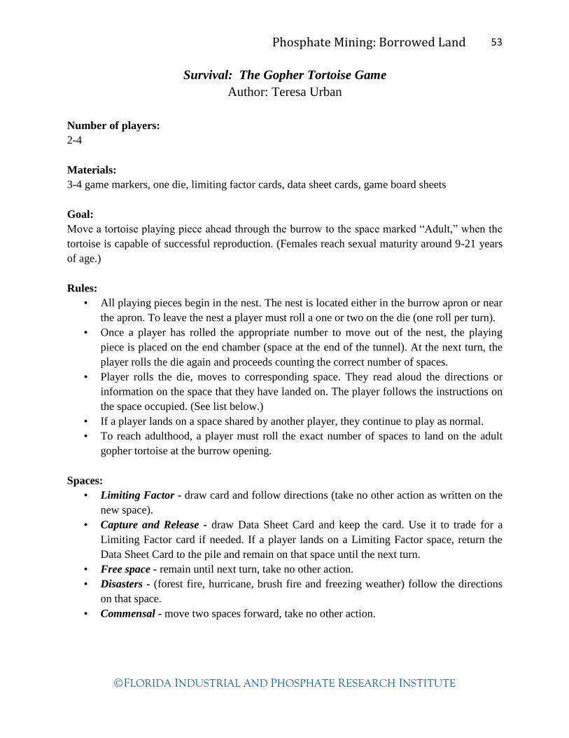
Phosphate Mining: Borrowed Land 53
FLORIDA INDUSTRIAL AND PHOSPHATE RESEARCH INSTITUTE
Survival: The Gopher Tortoise Game
Author: Teresa Urban
Number of players:
2-4
Materials:
3-4 game markers, one die, limiting factor cards, data sheet cards, game board sheets
Goal:
Move a tortoise playing piece ahead through the burrow to the space marked “Adult,” when the
tortoise is capable of successful reproduction. (Females reach sexual maturity around 9-21 years
of age.)
Rules:
• All playing pieces begin in the nest. The nest is located either in the burrow apron or near
the apron. To leave the nest a player must roll a one or two on the die (one roll per turn).
• Once a player has rolled the appropriate number to move out of the nest, the playing
piece is placed on the end chamber (space at the end of the tunnel). At the next turn, the
player rolls the die again and proceeds counting the correct number of spaces.
• Player rolls the die, moves to corresponding space. They read aloud the directions or
information on the space that they have landed on. The player follows the instructions on
the space occupied. (See list below.)
• If a player lands on a space shared by another player, they continue to play as normal.
• To reach adulthood, a player must roll the exact number of spaces to land on the adult
gopher tortoise at the burrow opening.
Spaces:
• Limiting Factor - draw card and follow directions (take no other action as written on the
new space).
• Capture and Release - draw Data Sheet Card and keep the card. Use it to trade for a
Limiting Factor card if needed. If a player lands on a Limiting Factor space, return the
Data Sheet Card to the pile and remain on that space until the next turn.
• Free space - remain until next turn, take no other action.
• Disasters - (forest fire, hurricane, brush fire and freezing weather) follow the directions
on that space.
• Commensal - move two spaces forward, take no other action.

Phosphate Mining: Borrowed Land 54
FLORIDA INDUSTRIAL AND PHOSPHATE RESEARCH INSTITUTE

Phosphate Mining: Borrowed Land 55
FLORIDA INDUSTRIAL AND PHOSPHATE RESEARCH INSTITUTE
Data Sheet #1
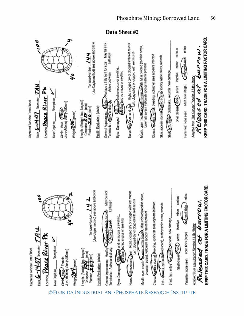
Phosphate Mining: Borrowed Land 56
FLORIDA INDUSTRIAL AND PHOSPHATE RESEARCH INSTITUTE
Data Sheet #2
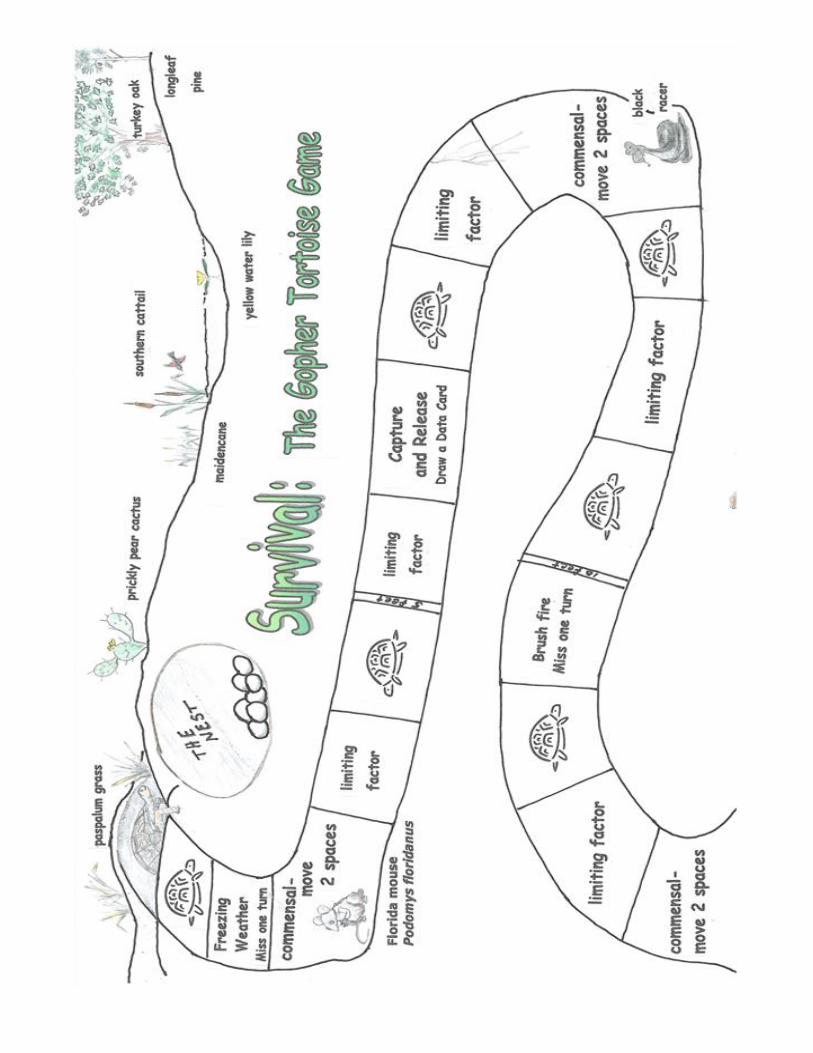
Phosphate Mining: Borrowed Land 57
FLORIDA INDUSTRIAL AND PHOSPHATE RESEARCH INSTITUTE

Phosphate Mining: Borrowed Land 58
FLORIDA INDUSTRIAL AND PHOSPHATE RESEARCH INSTITUTE
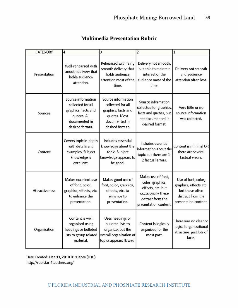
Phosphate Mining: Borrowed Land 59
FLORIDA INDUSTRIAL AND PHOSPHATE RESEARCH INSTITUTE
Multimedia Presentation Rubric

Phosphate Mining: Borrowed Land 60
FLORIDA INDUSTRIAL AND PHOSPHATE RESEARCH INSTITUTE
Gopher Tortoise Burrow Survey
Site: _________________________________
Surveyors: ___________________________________________
Burrow 1 Burrow 2 Burrow 3 Burrow 4 Burrow 5
GPS
coordinates
Elevation
Plant
community
Active or
inactive
(apron shows
tracks of GT;
opening in
good
condition)
Height/width
of opening
indicating
juvenile or
adult
Direction of
opening
(N,E,S,W)
Location of
burrow on
land (slope,
flat ground,
etc.)
Nearby
vegetation
types
Other notes
(vandalism,
etc.)

Phosphate Mining: Borrowed Land 61
FLORIDA INDUSTRIAL AND PHOSPHATE RESEARCH INSTITUTE
Lesson 6: Schoolyard Reclamation
Author: Teresa Urban
Introduction:
Before July 1, 1975, most phosphate-mined areas in central Florida were simply left alone. The
leftover moonscapes, spoil piles, pits, clay settling areas were “healed” by nature or “naturally
reclaimed.” Even so, the landscape, soil, and water flow was changed forever. After the
Reclamation Act of 1975, mining companies were required to restore the mined land back to its
former condition or make it usable for some other purpose. Mining engineers, environmental
specialists and scientists work together to plan for mining and reclamation before the land is
altered. “Naturally reclaimed” sites have also been used for parks, citrus groves, and cattle
grazing. However, it is a bit more difficult to reclaim one of these “naturally reclaimed” areas to
its original natural community or habitat. It takes time for trees to grow into a flatwoods,
sandhills, scrub, or swamp community. In the meantime exotic, invasive plants, such as
cogongrass, take over the area, interfering with the growth of natural plants that are native to the
original community. Those specialists involved in land reclamation have conducted many trial-
and-error tests to find the most effective means of removing invasive/exotic plants. There are
extensive research reports online that provide tested methodology information for the removal of
invasive/exotic plants.
This lesson is for those students and teachers who are interested in a hands-on reclamation
project; to work on the restoration of a disturbed site either on school grounds or at a nearby park
or reserve. The site may have been altered by phosphate mining or other human activities.
Students will appreciate the labor, trial and error, and challenges of the biologists and other
scientists who reclaim the phosphate mined lands.
Essential question: How have human activities impacted local land areas?
Students should be familiar with central Florida natural communities and techniques used to
identify them.
Activity:
This is a long-term lesson that incorporates real-world, scientific reclamation activities. Students
determine the natural community type of a given site (on schoolyard or nearby disturbed
property). They develop a plan to improve or enhance the natural area including adding new
trees, shrubs, grasses and herbaceous plants. If invasive exotic plants exist, students research and
develop a plan to eradicate the plants.
Estimated Time:
Two field trip days
Three to four 45-minute class periods
Extended time for actual work on land site improvement.
Grade Level:
6-8
Phosphate Mining: Borrowed Land 62
FLORIDA INDUSTRIAL AND PHOSPHATE RESEARCH INSTITUTE
Standards:
LA.6.4.2.2 SC.6.N.1.4
LA.7.4.2.2 LA.7.6.4.1 SC.7.E.6.6 SC.7.L.17.2 SC.7.L.17.3 SC.7.N.1.1
SC.7.N.1.3 SC.7.N.1.4 SC.7.N.1.5
LA.8.4.2.2
Objectives:
The students will…
1. Analyze abiotic and biotic factors existing in a given land area.
2. Identify the impact of human activities on this land area.
3. Describe the tested methods used to eradicate invasive and exotic plants.
4. Explain the competition between native and invasive/exotic plants in Florida’s natural
communities.
5. Identify the independent and dependent variables in an investigation to eradicate
invasive/exotic plants from a given land area.
Vocabulary:
native plants independent variables dependent variables
controlled variables herbaceous plants eradicate
exotic plants invasive hypothesis
Materials:
Computer lab with internet connection
Tree keys and field guides from previous lesson
Invasive plant recognition cards (downloaded and printed from internet)
Grid paper for drawing a map of the site area and for the improvement plan
Handout: Common Native Plants of Central Florida
Digital cameras
Large tape measure with metrics, approximately 30 meters or more
Garden stakes for marking corners of site
Bright colored marking tape available at hardware stores
Shovels
Watering pails or buckets
Garden gloves
Procedure:
1. Have students take digital photos of the site, mark it with stakes making a workable
quadrangle, and measure the perimeter. Identify and record the common trees, shrubs,
grasses and herbaceous plants growing there.
2. Back in the classroom have students—working in groups—draw a map of the site area,
indicating the existing trees, shrubs and plants. Maps should be grid marked using 1 meter of
land per 1 centimeter or another appropriate ratio. Have students color the areas where exotic
plants are present. They should record the natural plant community type.
3. Ask students how they might like to improve the land area—making it more like a natural
community that could support wildlife, etc. List these ideas including the new plants they
would like to add and the removal of invasive plants. (Provide students with the handout:
Common Native Plants of Central Florida.)
4. Have students draw a “new” map with existing native plants and showing where new plants

Phosphate Mining: Borrowed Land 63
FLORIDA INDUSTRIAL AND PHOSPHATE RESEARCH INSTITUTE
could be added.
5. Point out that scientists conduct many trials to determine the most effective methods of
invasive plant eradication. They must also be careful not to disturb the native plants already
growing there.
6. If an invasive plant has been identified at the land site, have students use the internet to find
several different methods of removal or eradication. Some methods may be less expensive or
less harmful to the environment. Some methods must be repeated.
7. Explain dependent and independent variables. The independent variable is the one that is
purposely changed by the scientist. The dependent variable is how it responds to the
change made to the independent variable. There must also be controlled variables.
Controlled variables serve as a standard of comparison with another variable to which
the control is identical except for one factor. Have students discuss and develop an
investigation plan to eradicate an invasive plant. (See example to the right.) They may use
the Invasive Plant Eradication Investigation worksheet as a guide.
http://www.sciencebuddies.org/science-fair-projects/project_variables.shtml
Analysis/Conclusion:
Collect maps of the areas for participation grades.
Assess the investigation plan to eradicate invasive plants.
Teacher Notes:
Select a small site (30 m. x 30 m.) on school grounds or nearby park that needs vegetation
improvement.
Obtain permission to make improvements to the site if desired.
Prepare keys and field guides used in previous lesson.
Download and print recognition cards of the most common plant exotics in central Florida—
http://plants.ifas.ufl.edu/node/683
Suggestions for those teachers that plan to actually improve a land area:
Funding—Lowe’s Outdoor Classroom grants: http:www.lowes.com/
Native plants information—“Waterwise Florida School Landscape”—contact Nancy Bissett,—
an expert on Florida native plants—The Natives in Davenport, Florida.
New vegetation planting—Demonstrate proper planting methods before assigning specific jobs
to students. Take before and after photos, log planting days, log watering days, etc. Water new
plants frequently at first and then less as the year progresses. Consider weeding and mulching.
Mowing might be needed to rejuvenate grasses or other herbaceous species. Flag new plants to
prevent them from being mowed over. Trees and shrubs may require fertilizing when planted.
Plants should be measured and logged at the time of planting and periodically throughout the
school year.
Vegetation assessment—use an appropriate method to measure plants before and after
improvements. See information on Reclamation: Vegetation Assessment Methods CD (FIPR
Institute).
Problem: Cogongrass covers a large area on the site.
Hypothesis: Spraying X herbicide before rain will kill the cogongrass blades.
Controlled variables: Entire area receives same amount of sunlight, rain water
Dependent variable: Vegetation assessment results after spraying
Independent variable: One half of area sprayed with X herbicide.

Phosphate Mining: Borrowed Land 64
FLORIDA INDUSTRIAL AND PHOSPHATE RESEARCH INSTITUTE
Invasive Plant Eradication
Investigation
Problem (Name and describe how the invasive
exotic plant is competing for space in
the land site.)
Hypothesis (State the expected outcome as a result
of the eradication method used.)
Independent Variable
(Describe the one thing that is
purposely changed in the
investigation, such as; applying
herbicide to the cogongrass on half the
plot; tilling the invasive plant on half
the plot; harvesting the aerial tubers of
the air potato, etc)
Dependent Variable
(What will be measured after the
eradication method has been applied?)
Controlled Variables
(List the variables that you will make
sure will stay the same in all testing
areas; plants receive same amount of
sunshine, water, etc.)

Phosphate Mining: Borrowed Land 65
FLORIDA INDUSTRIAL AND PHOSPHATE RESEARCH INSTITUTE
Common Native Plants of Central Florida
Pine Flatwoods or Scrubby Flatwoods Flatwoods occur on nearly level land. Water movement is very gradual with swamps, ponds,
marshes, and cypress domes interspersed. There are numerous soil types, primarily acidic, poorly
drained and coarse textured. The flatwoods of central and south Florida are best described as
savannahs with sparse trees and shrubs, and they require low-intensity ground fire. It is
recommended to begin the restoration of the flatwoods by seeding or planting for ground cover.
After the ground cover is established trees and shrubs are planted. Depending on weather
conditions and site preparation such as removing unwanted plants, the restoration process may
take 3+ years for establishment.
GRASSES
Andropogon sp. Bluestem (both M and X varieties)
Aristida strict var. beyrichiana Wiregrass (M)
Eragrostis elliottii Elliott lovegrass (X)
Eragrostis spectabilis Purple lovegrass (M)
Panicum hemitomon Maidencane (M)
Sorghastrum secundum Lopsided indiangrass (X)
Tripsacum dactyloides Eastern gamagrass (M)
WILDFLOWERS and Groundcover
Axclepias tuberosa Butterfly weed, Fl. (X) Balduina angustifolia
Yellow buttons (X) Coreopsis leavenworthii Liatris garberii
Prickly pear (X) Leavenworth’s goldenrod (M) Blazing star (M)
Elephantopus elatus Elephant’s foot (M-X) Opuntia humifusa
Panicum anceps Beaked panicum (M-X) Penstemon australis
Pink beardtongue (X) Pityopsis graminifolia var. tracyi Grass-leaved aster (M-X)
Polygonella polygama October flower (X) Rudbeckia hirta
Black-eyed susan (M) Salvia azurea Blue sage (X)
Salvia coccinea Scarlet sage (X) Solidago sp.
Goldenrod (M) Yucca filamentosa Bear grass (X)
SHRUBS
Licania michauxii Gopher apple (X) Lyonia lucida
Shiny lyonia (M) Myrica cerifera var. pumilla Dwarf wax myrtle (M)
Quercus chapmanii Chapman oak (X) Quercus minima
Dwarf live oak (M) Quercus myritifolia Myrtle oak (X)
Quercus pumila Runner oak (X) Serenoa repens
Saw palmetto (M) Vaccinium spp. Blueberry (M)
TREES
Cratageus flava Summer hawthorne (X)
Diospyros virginiana Persimmon (M)
Pinus clausa Sand pine (X)
Pinus elliottii Slash pine (M)

Phosphate Mining: Borrowed Land 66
FLORIDA INDUSTRIAL AND PHOSPHATE RESEARCH INSTITUTE
Pinus palustris Long leaf pine (X)
Quercus geminate Sand live oak (X)
Quercus incana Bluejack oak (X)
Quercus laevis Turkey oak (X)
Quercus virginiana Live oak (M)
Sabal palmetto Cabbage (Sabal) palm (M)
Sandhills These xeric plant communities are scattered throughout central Florida and occur in areas of
rolling terrain. They are often called Longleaf Pine – Turkey Oak Hills. The sands are yellow to
white, well-drained, dry, and low in nutrients. The plants of the sandhill need fire to keep them
healthy and to prevent encroachment of hardwood species. Trees are widely spaced and
groundcover, such as wiregrass and pine needles, provides most of the fuel to carry fire through
the sandhills. Following fire, bare sand becomes a good seedbed for many plants.
The well-drained soils of sandhills allow rapid downward movement of rainwater into ground
water supplies. Because of this rainwater handling characteristic, many of these communities
have been converted to school campuses, residential and commercial development, agriculture
and forestry land uses. Many wildlife species such as the southeastern American kestrel, red-
cockaded woodpecker, blue-tailed mole skink, and eastern indigo snake are in jeopardy of
extinction due to habitat loss.
The xeric plants of the scrubby flatwoods listed above are typical of the sandhills. Additional
plants are listed here.
GRASSES
Muhlenbergia capillaries Pink muhly grass (X)
Sporobolus junceus Pineland dropseed (X)
WILDFLOWERS and ground cover
Carphephorus corymbosus Florida paintbrush (X)
Monarda punctata Spotted beebalm (X)
Pteridum aquilinum Bracken fern (X)
SHRUBS
Asimina obovata Pawpaw (X)
Erythrina herbacea Coral bean (X)
Ilex vomitoria Yaupon holly (X)
Hardwood Hammock Hammocks occur on rolling terrain. The soils are somewhat poorly to well drained and high in
nutrients containing more organic material and litter than drier sites. The hammock is dominated
by thick stands of shade tolerant hardwoods and few pines. Understory is sparse in late
successional stages. By preventing naturally occurring fires in and near developed areas, people
actually have caused many natural sandhills and flatwoods to grow into hammock communities.

Phosphate Mining: Borrowed Land 67
FLORIDA INDUSTRIAL AND PHOSPHATE RESEARCH INSTITUTE
There are variations of hammocks.
Mesic hammocks of the peninsula are less diverse due to the absence of hardwood species
that are suited to northern climates. Common trees of the mesic hardwood are laurel oak, hop
hornbeam, blue beech, sweetgum, cabbage palm, American holly and southern magnolia.
Xeric hammocks occur on deep, well-drained, sandy soils where fire has been absent for long
periods of time. These open and dry hammocks contain live oak, sand-live oak, bluejack oak,
southern red oak, sand-post oak, and pignut hickory.
Coastal and hydric hammocks are relatively wet hardwood forests that are found between
uplands and true wetlands, rivers and lakes. These communities contain water oak, red
maple, Florida elm, cabbage palm, red cedar, blue-beech, and sweetgum.
The mesic trees and shrubs of the pine flatwoods may be found in hardwood hammocks.
GRASSES and grasslike
Carex spp. Caric sedges
Juncus spp. Rush
Panicum spp. Maidencane
WILDFLOWERS, ground cover and vines
Athyrium filix-femina Lady fern Dryopteris ludoviciana
Southern shield fern Erigeron spp. Fleabanes
Hypericum spp. St. John’s wort Osmunda cinnamomea
Cinnamon fern Osmunda regalis Royal fern
Rubus argutus Blackberry Verbena spp.
Verbena Woodwardia spp. Chain fern
SHRUBS
Callicarpa americana Beautyberry
Lantana spp. Lantana
Myrica cerifera Wax myrtle
Rhamnus caroliniana Carolina buckthorn
Vaccinium arboreum Sparkleberry
Verburnum dentatum Arrowwood
Viburnum rufidulum Rusty viburnum
Zambia pumila Coontie
TREES
Acer rubrum Red maple
Carpinus caroliniana American hornbeam (Blue beech)
Carya glabra Pignut hickory
Cornus florida Flowering dogwood
Fagus grandifolia American beech
Ilex cassine Dahoon holly
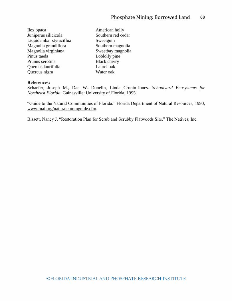
Phosphate Mining: Borrowed Land 68
FLORIDA INDUSTRIAL AND PHOSPHATE RESEARCH INSTITUTE
Ilex opaca American holly
Juniperus silicicola Southern red cedar
Liquidambar styraciflua Sweetgum
Magnolia grandiflora Southern magnolia
Magnolia virginiana Sweetbay magnolia
Pinus taeda Loblolly pine
Prunus serotina Black cherry
Quercus laurifolia Laurel oak
Quercus nigra Water oak
References:
Schaefer, Joseph M., Dan W. Donelin, Linda Cronin-Jones. Schoolyard Ecosystems for
Northeast Florida. Gainesville: University of Florida, 1995.
“Guide to the Natural Communities of Florida.” Florida Department of Natural Resources, 1990,
www.fnai.org/naturalcommguide.cfm.
Bissett, Nancy J. “Restoration Plan for Scrub and Scrubby Flatwoods Site.” The Natives, Inc.
Phosphate Mining: Borrowed Land 69
FLORIDA INDUSTRIAL AND PHOSPHATE RESEARCH INSTITUTE
Materials
Computer lab with LCD projector for demonstrating the assignment
Software such as Microsoft Office Word or Inspiration
DVD player or computer that plays DVDs with LCD projector
AA batteries
Centimeter grid paper
Pencils
Clipboards
Meter stick
5-6 plastic 16 oz. water bottles
Centimeter ruler
Play sand
Aquarium gravel
Topsoil or potting soil
Small bags
Funnel
Newspapers
Small hand spade
Science probes for temperature and pH (if available)
2 coffee cans
Hammer
Bottles of water (same size)
Weather thermometer
Glass lab thermometer (soil temp)
Digital cameras
Borrow from FIPR Institute (863-534-7160) Resource CD
Ore Body Battleship Game
Cycles of Matter on Earth PowerPoint
The Phosphate Story: Florida’s Hidden Treasure DVD
National Audubon Society: Field Guide to Florida Handbook
GPS receivers
Soil pH meter
Phosphate Mining: Borrowed Land 70
FLORIDA INDUSTRIAL AND PHOSPHATE RESEARCH INSTITUTE
Resources
Websites
Florida Industrial and Phosphate Research Institute (FIPR Institute)
http://www.fipr.poly.usf.edu
“Cupcake Core Sampling”—Women in Mining
http://www.coaleducation.org/lessons/wim/4.htm
“Phosphorus: A Looming Crisis,” Scientific American, June 2009.
http://www.scientificamerican.com/article.cfm?id=phosphorus-a-looming-crisis
Phosphorus Cycle
http://www.lenntech.com/phosphorus-cycle.htm
Phosphorus Cycle Animation
http://www.wadsworthmedia.com/biology/starr_udl11_tour/phos_anim.html
Rubric templates
http://rubistar.4teachers.org/
Guide to the Natural Communities of Florida. Florida Department of Natural Resources, 1990,
www.fnai.org/naturalcommguide.cfm.
Information for possible natural community field trip locations:
http://www.polk-county.net/parks.aspx?menu_id=52
http://www.floridastateparks.org/coltcreek/default.cfm
http://www.floridastateparks.org/lakekissimmee/default.cfm
http://www.fl-dof.com/state_forests/lake_wales_ridge.html
PowerPoint—Gopher Tortoise: A Species in Decline
http://www.gophertortoisecouncil.org/
Endangered Species
http://www.floridaendangeredspeciesnetwork.org/specieslist.htm
Invasive plant recognition cards
http://plants.ifas.ufl.edu/node/683
Introduction to variables
http://www.sciencebuddies.org/science-fair-projects/project_variables.shtml
Books
Ashton, Patricia Sawyer, and Ray E. Ashton Jr. The Gopher Tortoise A Life History. Sarasota,
FL: Pineapple Press, Inc., 2004.
Phosphate Mining: Borrowed Land 71
FLORIDA INDUSTRIAL AND PHOSPHATE RESEARCH INSTITUTE
Enge, Kevin M., Joan E. Berish, Rebecca Bolt, Annie Dziergowski, Henry R. Mushinsky.
"Biological Status Report Gopher Tortoise." Florida Fish and Wildlife Conservation
Commission, 2006.
Schueler, Donald G. The Gopher Tortoise. Berkeley Heights, NJ: Enslow Publishers, Inc., 2003.
Wood, Don A. Florida's Fragile Wildlife Conservation and Management. Gainesville, FL:
University Press of Florida, 2001.

Phosphate Mining: Borrowed Land 72
FLORIDA INDUSTRIAL AND PHOSPHATE RESEARCH INSTITUTE