picnic areas activity paths
TRANSCRIPT
AREASACTIVITYin theA o s t a V a l l e y
andPATHS
PICNIC
1
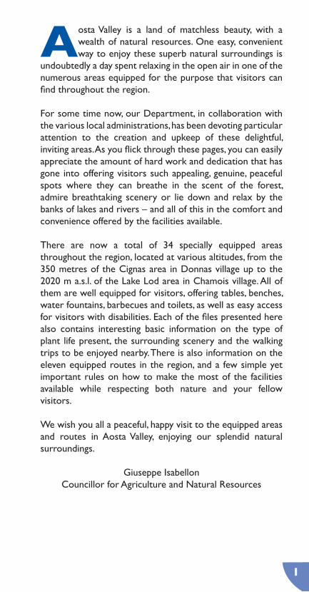
Aosta Valley is a land of matchless beauty, with a wealth of natural resources. One easy, convenient way to enjoy these superb natural surroundings is
undoubtedly a day spent relaxing in the open air in one of the numerous areas equipped for the purpose that visitors can find throughout the region.
For some time now, our Department, in collaboration with the various local administrations, has been devoting particular attention to the creation and upkeep of these delightful, inviting areas. As you flick through these pages, you can easily appreciate the amount of hard work and dedication that has gone into offering visitors such appealing, genuine, peaceful spots where they can breathe in the scent of the forest, admire breathtaking scenery or lie down and relax by the banks of lakes and rivers – and all of this in the comfort and convenience offered by the facilities available.
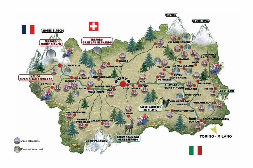
There are now a total of 34 specially equipped areas throughout the region, located at various altitudes, from the 350 metres of the Cignas area in Donnas village up to the 2020 m a.s.l. of the Lake Lod area in Chamois village. All of them are well equipped for visitors, offering tables, benches, water fountains, barbecues and toilets, as well as easy access for visitors with disabilities. Each of the files presented here also contains interesting basic information on the type of plant life present, the surrounding scenery and the walking trips to be enjoyed nearby. There is also information on the eleven equipped routes in the region, and a few simple yet important rules on how to make the most of the facilities available while respecting both nature and your fellow visitors.
We wish you all a peaceful, happy visit to the equipped areas and routes in Aosta Valley, enjoying our splendid natural surroundings.
Giuseppe IsabellonCouncillor for Agriculture and Natural Resources
2
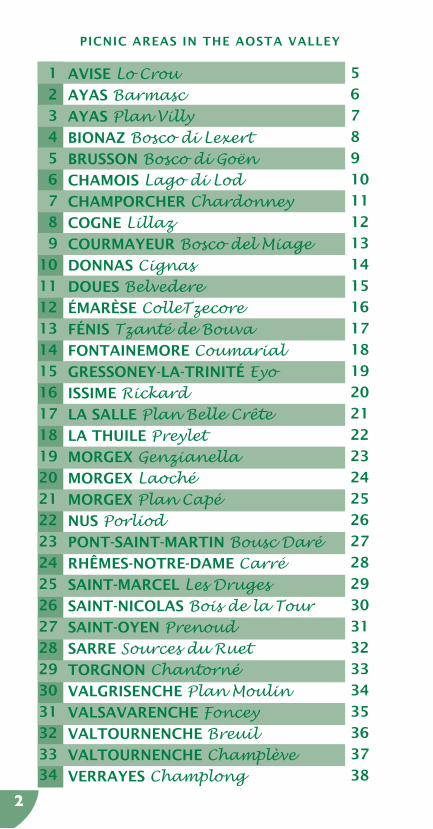
AVISE Lo CrouAYAS BarmascAYAS Plan VillyBIONAZ Bosco di LexertBRUSSON Bosco di GoënCHAMOIS Lago di LodCHAMPORCHER ChardonneyCOGNE LillazCOURMAYEUR Bosco del MiageDONNAS CignasDOUES BelvedereÉMARÈSE ColleTzecoreFÉNIS Tzanté de Bouva FONTAINEMORE CoumarialGRESSONEY-LA-TRINITÉ EyoISSIME RickardLA SALLE Plan Belle CrêteLA THUILE PreyletMORGEX GenzianellaMORGEX LaochéMORGEX Plan CapéNUS PorliodPONT-SAINT-MARTIN Bousc DaréRHÊMES-NOTRE-DAME CarréSAINT-MARCEL Les DrugesSAINT-NICOLAS Bois de la TourSAINT-OYEN PrenoudSARRE Sources du RuetTORGNON ChantornéVALGRISENCHE Plan MoulinVALSAVARENCHE FonceyVALTOURNENCHE BreuilVALTOURNENCHE ChamplèveVERRAYES Champlong
5
6
7
8
9
10
11
12
13
14
15
16
17
18
19
20
21
22
23
24
25
26
27
28
29
30
31
32
33
34
35
36
37
38
1
2
3
4
5
6
7
8
9
10
11
12
13
14
15
16
17
18
19
20
21
22
23
24
25
26
27
28
29
30
31
32
3334
PICNIC AREAS IN THE AOSTA VALLEY

3
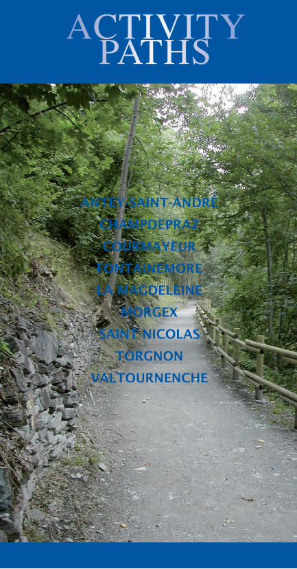
ACTIVITY PATHS IN THE AOSTA VALLEY
ANTEY-SAINT-ANDRÉ (for disabled)ANTEY-SAINT-ANDRÉ CHAMPDEPRAZ (for disabled)COURMAYEURFONTAINEMORELA MAGDELEINEMORGEXSAINT-NICOLAS (for the blind)TORGNONVALTOURNENCHE (Maen)VALTOURNENCHE (Cré-du-Pont)
4040414142424343444445
123456789
1011
4
AVISEAYAS
BIONAZBRUSSONCHAMOIS
CHAMPORCHERCOGNE
COURMAYEURDONNASDOUES
ÉMARÈSEFÉNIS
FONTAINEMOREGRESSONEY-LA-TRINITÉ
ISSIMELA SALLE
LA THUILEMORGEX
NUSPONT-SAINT-MARTIN
RHÊMES-NOTRE-DAMESAINT-MARCELSAINT-NICOLAS
SAINT-OYENSARRE
TORGNONVALGRISENCHE
VALSAVARENCHEVALTOURNENCHE
VERRAYES
PICNICAREAS
PICNIC
AREAS
5
1Avise Lo Crou
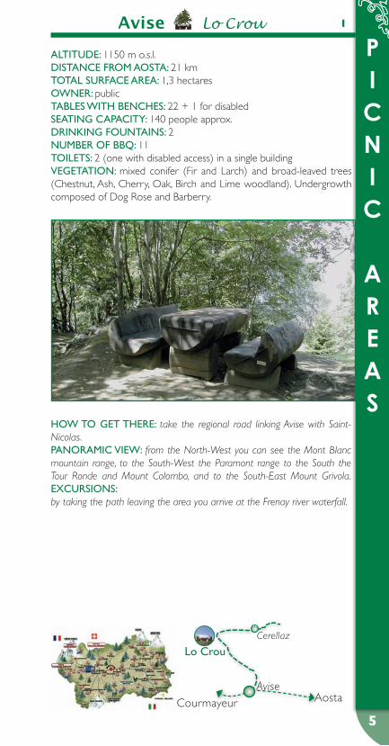
ALTITuDe: 1150 m o.s.l.DIsTANCe FROM AOsTA: 21 kmTOTAL suRFACe AReA: 1,3 hectaresOWNeR: publicTABLes WITH BeNCHes: 22 + 1 for disabledseATING CApACITY: 140 people approx.DRINKING FOuNTAINs: 2NuMBeR OF BBq: 11TOILeTs: 2 (one with disabled access) in a single buildingVeGeTATION: mixed conifer (Fir and Larch) and broad-leaved trees (Chestnut, Ash, Cherry, Oak, Birch and Lime woodland). Undergrowth composed of Dog Rose and Barberry.
HOW TO GeT THeRe: take the regional road linking Avise with Saint-Nicolas.pANORAMIC VIeW: from the North-West you can see the Mont Blanc mountain range, to the South-West the Paramont range to the South the Tour Ronde and Mount Colombo, and to the South-East Mount Grivola.eXCuRsIONs: by taking the path leaving the area you arrive at the Frenay river waterfall.
Cerellaz
Lo Crou
AviseAostaCourmayeur
PICNIC
AREAS
6
2 Ayas Barmasc2
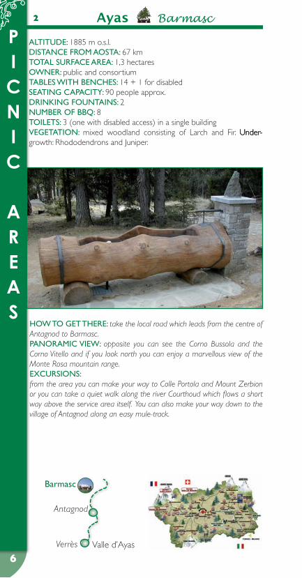
ALTITuDe: 1885 m o.s.l.DIsTANCe FROM AOsTA: 67 kmTOTAL suRFACe AReA: 1,3 hectaresOWNeR: public and consortiumTABLes WITH BeNCHes: 14 + 1 for disabledseATING CApACITY: 90 people approx.DRINKING FOuNTAINs: 2NuMBeR OF BBq: 8TOILeTs: 3 (one with disabled access) in a single buildingVeGeTATION: mixed woodland consisting of Larch and Fir. Under- Under-Under-growth: Rhododendrons and Juniper.
HOW TO GeT THeRe: take the local road which leads from the centre of Antagnod to Barmasc.pANORAMIC VIeW: opposite you can see the Corno Bussola and the Corno Vitello and if you look north you can enjoy a marvellous view of the Monte Rosa mountain range. eXCuRsIONs: from the area you can make your way to Colle Portola and Mount Zerbion or you can take a quiet walk along the river Courthoud which flows a short way above the service area itself. You can also make your way down to the village of Antagnod along an easy mule-track.
Valle d’AyasVerrès
Antagnod
Barmasc

PICNIC
AREAS
7
3Ayas Plan Villy 3
ALTITuDe: 1576 m o.s.l.DIsTANCe FROM AOsTA: 65 kmTOTAL suRFACe AReA: 2 hectaresOWNeR: consortiumTABLes WITH BeNCHes: 18 + 2 for disabledseATING CApACITY: 120 people approx.DRINKING FOuNTAINs: 2NuMBeR OF BBq: 6TOILeTs: 7 (one with disabled acess) in 3 separate buildingsVeGeTATION: thriving woodland, almost all Fir with sporadic Larch specimens. Undergrowth composed of Juniper, Heather, Barberry and Blueberry.
HOW TO GeT THeRe: take the regional road in Valle d’Ayas, after passing the town of Champoluc.pANORAMIC VIeW: this area, located at the end of the valley, provides views to the South-East of Becca Piure, to the South Mount Zerbion, to the North Rocca di Verra, Breithorn and Rocce Nere.eXCuRsIONs:
using the cablecar you can arrive at Crest from where you can admire • Mount Testa Grigia and reach the village of Cunéaz, a typical mountain settlement, as well as Lakes Pinter and Perrin.By crossing the River Evançon near the village of Frachey you can arrive • at the valley of Tournalin and Colle di Nana.The town of Saint-Jacques is the departure point for ascents to the Mount • Rosa mountain range via Verra Valley; it is also possible, departing from the same town, to reach "Colle delle Cime Bianche".
Valle d’AyasVerrès
Champolucplan Villy

PICNIC
AREAS
8
4 Bionaz Bosco di Lexert
ALTITuDe: 1550 m o.s.l.DIsTANCe FROM AOsTA: 23 kmTOTAL suRFACe AReA: 7 hectaresOWNeR: consortium and privateTABLes WITH BeNCHes: 45 + 3 for disabledseATING CApACITY: 290 people approx.DRINKING FOuNTAINs: 6NuMBeR OF BBq: 17TOILeTs: 10 (one with disabled access) in 5 separate buildingsVeGeTATION: mature, mainly Scottish Pine trees forest; groups of Larch and Fir. Juniper undergrowth.
HOW TO GeT THeRe: take the Valpelline regional road to the Lexert district.pANORAMIC VIeW: to the East you can see Dent d’Herens, the Tza de Tzan glacier, Becca de Luseney and Les Grandes Murailles; to the West Vessona Valley, while to the North the Morion mountain chain and Colle Crête-Sèche that leads to the Otemma glacier. eXCuRsIONs: take the private road that to the right run on the length of the river to the village of Rûz, You arrive near the Alpe Primo from where you can reach the Berrier pasture. Continuing onwards, you reach the Crête-Sèche Refuge with the steep Aroletta mountain range behind it.
Valpelline
BionazOllomont
Bosco di Lexert
Aosta
PICNIC
AREAS
9
5Brusson Bosco di Goën
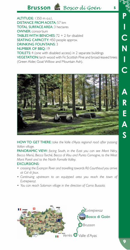
ALTITuDe: 1350 m o.s.l..DIsTANCe FROM AOsTA: 57 kmTOTAL suRFACe AReA: 3 hectaresOWNeR: consortiumTABLes WITH BeNCHes: 72 + 2 for disabledseATING CApACITY: 450 people approx.DRINKING FOuNTAINs: 3NuMBeR OF BBq: 19TOILeTs: 4 (one with disabled access) in 2 separate buildingsVeGeTATION: larch wood with Fir, Scottish Pine and broad-leaved trees (Green Alder, Goat Willow and Mountain Ash).
HOW TO GeT THeRe: take the Valle d’Ayas regional road after passing Vollon village.pANORAMIC VIeW: facing South, in the East you can see Mont Néry, Becca Meriú, Becca Torché, Becca di Vlou and Punta Comagne, to the West Mont Pareil and to the North Fornolle Valley.eXCuRsIONs:
crossing the Evançon River and travelling towards Rû Courthoud you arrive • at Col di Joux.Continuing upstream to an equipped area you reach the town of • Extrepieraz.You can reach Salomon village in the direction of Corno Bussola.•
Valle d’AyasVerrès
Extrepieraz
Brusson
Bosco di Goën

PICNIC
AREAS
10
Chamois Lago di Lod6
ALTITuDe: 2020 m o.s.l.DIsTANCe FROM AOsTA: 35 kmTOTAL suRFACe AReA: 0,5 hectaresOWNeR: publicTABLes WITH BeNCHes: 34seATING CApACITY: 205 people approx.DRINKING FOuNTAINs: 3NuMBeR OF BBq: 15TOILeTs: 2 in a single buildingVeGeTATION: mixed Larch and Fir woodland. Undergrowth composed of Juniper, Rhododendron and Goat Willow.
HOW TO GeT THeRe: you can only arrive using the cablecar that de-parts from the Buisson village in the Borough of Antey-Saint-André, since access to vehicles is not allowed in the Borough of Chamois.pANORAMIC VIeW: from the area in the East you can see Mount Fon-tané and Grand Dent, to the West Punta Fontanella, to the South Punta Tersiva and Becca di Luseney, to the North Petite and Grande Muraille and the Château des Dames.eXCuRsIONs:
on reaching Clavalité Sanctuary you can climb to Punta Falinère.• Instead, on the way down in the direction of the Cheneil district, you can • go back up to Col di Nana.
Châtillon
Valtournenche
Buisson
Chamois
Lago di Lod
PICNIC
AREAS
11
7Champorcher Chardonney
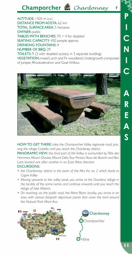
ALTITuDe: 1420 m o.s.l.DIsTANCe FROM AOsTA: 62 kmTOTAL suRFACe AReA: 5 hectaresOWNeR: publicTABLes WITH BeNCHes: 70 + 4 for disabledseATING CApACITY: 450 people approx.DRINKING FOuNTAINs: 4NuMBeR OF BBq: 29TOILeTs: 9 (3 with disabled access) in 3 separate buildingsVeGeTATION: mixed Larch and Fir woodland. Undergrowth composed of Juniper, Rhododendron and Goat Willow.
HOW TO GeT THeRe: take the Champorcher Valley regionale road, pas-sing the village Castello until you reach the Chardoney district.pANORAMIC VIeW: this final part of the Valley is surrounded by Tête des Hommes, Mount Glassier, Mount Déla, Tour Ponton, Rosa dei Banchi and Bec Laris located one after another in an East-West direction.eXCuRsIONs:
the Chardonney district is the point of the Alta Via no. 2 which leads to • Cogne ValleyMoving upwards to the valley peak, you arrive at the Dondena refuge in • the locality of the same name, and continue onwards until you reach the refuge of lake Miserin.On reaching, via the public road, the Mont Blanc locality, you arrive in an • area with various footpath departure points that cover the land around the Natural Park Mont Avic.
Hône
Champorcher
Chardonney

PICNIC
AREAS
12
8 Cogne Lillaz
ALTITuDe: 1605 m o.s.l.DIsTANCe FROM AOsTA: 30 kmTOTAL suRFACe AReA: 4,5 hectaresOWNeR: publicTABLes WITH BeNCHes: 45 + 2 for disabledseATING CApACITY: 280 people approx.DRINKING FOuNTAINs: 3NuMBeR OF BBq: 14TOILeTs: 3 (one with disabled access) in a single buildingVeGeTATION: wood mainly composed of Larch mixed with Fir and Swiss Stone Pine. Undergrowth composed of Juniper and Barberry.
HOW TO GeT THeRe: you can arrive by travelling in the direction of the Valley of Lillaz, after Cogne town.pANORAMIC VIeW: from this area you can see Val Valeille to the South, Mount Penne Blanche to the North and to the East Urtier Valley with the relative waterfalls in Lillaz.eXCuRsIONs: from the Lillaz district, follow the path that rises to the left of the river to the Urtier Valley in order to reach the rocky drop, the origin of the Lillaz waterfalls; continuing onwards you arrive at the small village of Goilles and from here climb along the valley to reach the Bardoney valley and mountain pasture.
Cogne
Valnontey
Gimillian
Lillaz
Lillaz
Aymavilles
PICNIC
AREAS
13
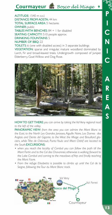
9Courmayeur Bosco del Miage
ALTITuDe: 1540 m o.s.l.DIsTANCe FROM AOsTA: 44 kmTOTAL suRFACe AReA: 5 hectaresOWNeR: publicTABLes WITH BeNCHes: 84 + 1 for disabledseATING CApACITY: 510 people approx.DRINKING FOuNTAINs: 5NuMBeR OF BBq: 22TOILeTs: 6 (one with disabled access) in 3 separate buildingsVeGeTATION: sparse and irregular, mature woodland dominated by Larch, Fir and broad-leaved trees. Undergrowth composed of Juniper, Elderberry, Goat Willow and Dog Rose.
HOW TO GeT THeRe: you can arrive by taking the Val Veny regional road to the left of the valley.pANORAMIC VIeW: from the area you can admire the Mont Blanc to the East, to the North Les Grandes Jorasses, Aiguille Noire, Les Dames des Anglais and Dente del Gigante, to the West the Miage and Brouillard gla-ciers, while Tête de Chécrouit, Punta Youla and Mont Chétif are located to the South.eXCuRsIONs:
when you reach the locality of Combal you can follow the path till the • Mont Fortin and to the Col des Chavannes; otherwise is walking forward to the Lake Combal and coming to the meadows of Arp and finally reaching the Mont Favre.From the refuge Elisabetta is possible to climbs up until the Col de la • Seigne, following the Tour du Mont Blanc track.
Val Ferret
Bosco del Miage
Courmayeur
Val Veny

PICNIC
AREAS
14
10 Donnas Cignas
ALTITuDe: 350 m o.s.l.DIsTANCe FROM AOsTA: 48 kmTOTAL suRFACe AReA: 2,5 hectaresOWNeR: publicTABLes WITH BeNCHes: 40 + 2 for disabledseATING CApACITY: 252 people approx.DRINKING FOuNTAINs: 4NuMBeR OF BBq: 32TOILeTs: 3 (one with disabled access) in a single buildingVeGeTATION: forest mainly composed of Chestnut with sporadic other broad-leaved trees (Birch Hazelnut Goat Willow, Ash, Poplar and Cherry). Some isolated Larch specimens. Undergrowth composed of Barberry, Dog Rose and White Willow in shrub form.
HOW TO GeT THeRe: you can arrive by crossing the Dora Baltea River at the altitude of Donnas town along State Road 26.pANORAMIC VIeW: from this place, located at the start of the central valley, you can look North-West to Bard Fortress, and in the direction of the mouth of Lys Valley to see the ancient Castellaccio of Pont-Saint-Martin.eXCuRsIONs:
cross the mule track that departs from the Outrefer district to reach "I • pian" lower valley pasture and continue onwards along the path leading to the Cormoney mountain pasture.Take the public road to the Les Donnes district and then the path leading • to the Moja mountain pastures.
Verrès Donnas
Pont-Saint-Martin
Cignas
PICNIC
AREAS
15
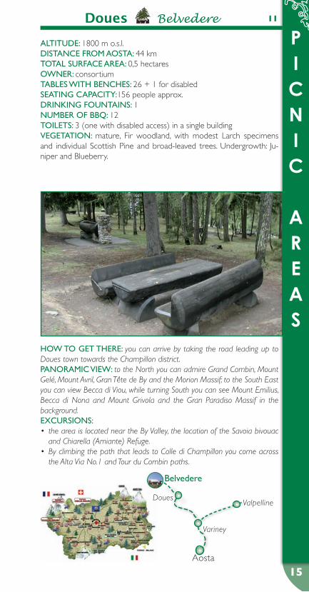
11Doues Belvedere
ALTITuDe: 1800 m o.s.l.DIsTANCe FROM AOsTA: 44 kmTOTAL suRFACe AReA: 0,5 hectaresOWNeR: consortiumTABLes WITH BeNCHes: 26 + 1 for disabledseATING CApACITY:156 people approx.DRINKING FOuNTAINs: 1NuMBeR OF BBq: 12TOILeTs: 3 (one with disabled access) in a single buildingVeGeTATION: mature, Fir woodland, with modest Larch specimens and individual Scottish Pine and broad-leaved trees. Undergrowth: Ju-niper and Blueberry.
HOW TO GeT THeRe: you can arrive by taking the road leading up to Doues town towards the Champillon district.pANORAMIC VIeW: to the North you can admire Grand Combin, Mount Gelé, Mount Avril, Gran Tête de By and the Morion Massif; to the South East you can view Becca di Viou, while turning South you can see Mount Emilius, Becca di Nona and Mount Grivola and the Gran Paradiso Massif in the background.eXCuRsIONs:
the area is located near the By Valley, the location of the Savoia bivouac • and Chiarella (Amiante) Refuge. By climbing the path that leads to Colle di Champillon you come across • the Alta Via No.1 and Tour du Combin paths.
Variney
ValpellineDoues
Belvedere
Aosta
PICNIC
AREAS
16
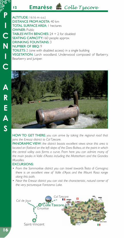
12 Emarèse Colle Tzecore
ALTITuDe: 1616 m o.s.l.DIsTANCe FROM AOsTA: 40 kmTOTAL suRFACe AReA: 1 hectaresOWNeR: PublicTABLes WITH BeNCHes: 24 + 2 for disabledseATING CApACITY:160 people approx.DRINKING FOuNTAINs: 3NuMBeR OF BBq: 9TOILeTs: 2 (one with disabled access) in a single buildingVeGeTATION: Larch woodland. Underwood composed of Barberry, Bearberry and Juniper.
HOW TO GeT THeRe: you can arrive by taking the regional road that joins the Eresaz district to Col Tzecore.pANORAMIC VIeW: the district boasts excellent views since this area is located on flatland on the left slope of the Dora Baltea, at the point in which the central valley axis forms a curve. From here you can admire many of the main peaks in Valle d’Aosta including the Matterhorn and the Grandes Murailles. eXCuRsIONs:
From the Sommarèse district you can travel towards Testa di Comagna; • there is an excellent view of Valle d’Ayas and the Mount Rosa range along this path.Near the Eresaz district you can visit the characteristic, natural corner of • the very picturesque Fantasma Lake.
Col TzecoreCol de Joux
EmarèseColle Tzecore
Saint-Vincent
PICNIC
AREAS
17
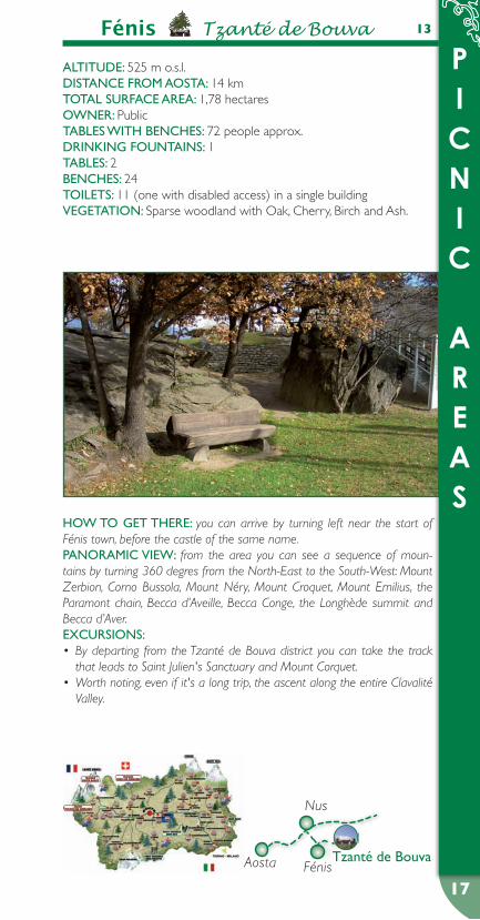
13Fénis Tzanté de Bouva
ALTITuDe: 525 m o.s.l.DIsTANCe FROM AOsTA: 14 kmTOTAL suRFACe AReA: 1,78 hectaresOWNeR: PublicTABLes WITH BeNCHes: 72 people approx.DRINKING FOuNTAINs: 1TABLes: 2BeNCHes: 24TOILeTs: 11 (one with disabled access) in a single buildingVeGeTATION: Sparse woodland with Oak, Cherry, Birch and Ash.
HOW TO GeT THeRe: you can arrive by turning left near the start of Fénis town, before the castle of the same name.pANORAMIC VIeW: from the area you can see a sequence of moun-tains by turning 360 degres from the North-East to the South-West: Mount Zerbion, Corno Bussola, Mount Néry, Mount Croquet, Mount Emilius, the Paramont chain, Becca d’Aveille, Becca Conge, the Longhède summit and Becca d’Aver.eXCuRsIONs:
By departing from the Tzanté de Bouva district you can take the track • that leads to Saint Julien's Sanctuary and Mount Corquet.Worth noting, even if it's a long trip, the ascent along the entire Clavalité • Valley.
Aosta
Nus
FénisTzanté de Bouva

PICNIC
AREAS
18
14 Fontainemore Coumarial
ALTITuDe: 1440 m o.s.l.DIsTANCe FROM AOsTA: 69 kmTOTAL suRFACe AReA: 0,3 hectaresOWNeR: publicTABLes WITH BeNCHes: 13 + 1for disabledseATING CApACITY: 84 people approx.DRINKING FOuNTAINs: 2NuMBeR OF BBq: 14TOILeTs: 3 (one with disabled access) in a single buildingVeGeTATION: varied and composed of Beech, Fir, Birch and some Larch specimens.
HOW TO GeT THeRe: you can arrive by taking the Lys Valley regional road until you pass Fontainemore town. From here continue onwards until you reach the diversion on the River Lys, and follow the direction for Cou-marial.pANORAMIC VIeW: in front of you, you can admire the Dames de Chal-land summits and, to the right, Mount Néry.eXCuRsIONs:
from the equipped area you can take excursions that lead to the Coda • Refuge, Mount Mars and Vargno Lake.You can reach the Alta Via No. 1 which, starting in Donnas, travels the • altitude of the side valleys to the left, up to Courmayeur
Gressoney
Fontainemore
Coumarial
Pont-Saint-Martin
PICNIC
AREAS
19
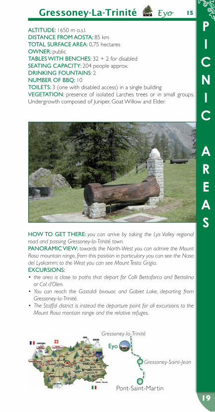
Gressoney-La-Trinité Eyo 15
ALTITuDe: 1650 m o.s.l.DIsTANCe FROM AOsTA: 85 kmTOTAL suRFACe AReA: 0,75 hectaresOWNeR: publicTABLes WITH BeNCHes: 32 + 2 for disabledseATING CApACITY: 204 people approx.DRINKING FOuNTAINs: 2NuMBeR OF BBq: 10TOILeTs: 3 (one with disabled access) in a single buildingVeGeTATION: presence of isolated Larches trees or in small groups. Undergrowth composed of Juniper, Goat Willow and Elder.
HOW TO GeT THeRe: you can arrive by taking the Lys Valley regional road and passing Gressoney-la-Trinité town.pANORAMIC VIeW: towards the North-West you can admire the Mount Rosa mountain range, from this position in particulary you can see the Naso del Lyskamm; to the West you can see Mount Testa Grigia.eXCuRsIONs:
the area is close to paths that depart for Colli Bettaforca and Bettolina • or Col d’Olen.You can reach the Gastaldi bivouac and Gabiet Lake, departing from • Gressoney-la-Trinité.The Staffal district is instead the departure point for all excursions to the • Mount Rosa montain range and the relative refuges.
Gressoney-la-Trinité
Gressoney-Saint-Jean
eyo
Pont-Saint-Martin
PICNIC
AREAS
20
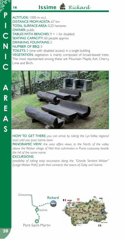
Issime Rickard 16
ALTITuDe: 1000 m o.s.l.DIsTANCe FROM AOsTA: 67 kmTOTAL suRFACe AReA: 0,25 hectaresOWNeR: publicTABLes WITH BeNCHes: 9 + 1 for disabledseATING CApACITY: 60 people approx.DRINKING FOuNTAINs: 2NuMBeR OF BBq: 5TOILeTs: 3 (one with disabled access) in a single buildingVeGeTATION: vegetation is mainly composed of broad-leaved trees. The most represented among these are Mountain Maple, Ash, Cherry, Lime and Birch.
HOW TO GeT THeRe: you can arrive by taking the Lys Valley regional road until you pass Issime town.pANORAMIC VIeW: the area offers views, to the North, of the valley above the Walser village of Niel that culminates in Punta Lazouney beside the hill of the same name.eXCuRsIONs: possibility of taking easy excursions along the “Grande Sentiero Walser” (Large Walser Path) path that connects the towns of Gaby and Issime.
Gressoney
Issime
Rickard
Pont-Saint-Martin

PICNIC
AREAS
21
La Salle Plan Belle Crête 17
ALTITuDe: 1700 m o.s.l.DIsTANCe FROM AOsTA: 34 kmTOTAL suRFACe AReA: 0,36 hectaresOWNeR: publicTABLes WITH BeNCHes: 12 + 2 for disabledseATING CApACITY: 84 people approx.DRINKING FOuNTAINs: 1NuMBeR OF BBq: 7TOILeTs: 3 (one with disabled access) in a single buildingVeGeTATION: the area is mostly situated in an old Larch pasture, sur-rounded by Spruce Fir.
HOW TO GeT THeRe: after passing La Salle town, continue onwards in the direction of Planaval until you pass the Morge Dessus district.pANORAMIC VIeW: in front of the area you can clearly see the "Vallon" and the Promoud with Mount Paramont in the background; to the West you can admire the Mont Blanc mountain chain; to the East you can look across the central valley to the side valleys of Valgrisenche, Valsavarenche and Rhêmes Valley.eXCuRsIONs: excursions leave the area to Grassey, the cottages in Licony, the lake of the same name and the new Pascal bivouac on Testa Licony.
Courmayeur
plan Belle Crête
La SalleAosta

PICNIC
AREAS
22
La Thuile Preylet 18
ALTITuDe: 1450 m o.s.l.DIsTANCe FROM AOsTA: 42 kmTOTAL suRFACe AReA: 2,5 hectaresOWNeR: publicTABLes WITH BeNCHes: 51 + 1 for disabledseATING CApACITY: 312 people approx.DRINKING FOuNTAINs: 3NuMBeR OF GRILLs: 22TOILeTs: 2 (one with disabled access) in a single buildingVeGeTATION: thriving, mature Fir and Larch woodland. Undergrowth composed of Juniper, Dog Rose and Hawthorn.
HOW TO GeT THeRe: depart from La Thuile town and take the road leading to the start of the Piccolo San Bernardo cablecar.pANORAMIC VIeW: looking North, turn in a clockwise direction to see Mount Belleface, Tête des Jeunes and Tête des Vieux, Punta della Croce, Mount Colmet, Grand Assaly, the Ruitor glacier and Testa di Les Suches lo-cated to the West. eXCuRsIONs:
you can reach Mount du Parc, by departing from La Thuile town.• From the La Joux district you can reach Glacier Lake up to Bella Comba • Valley.From Buic village you can reach Le Baite in Crétaz and Foillex and, after-• wards, Colle della Croce.
La Thuile
Colle del Piccolo San Bernardo
Col San Carlopreylet
Pré-Saint-Didier
PICNIC
AREAS
23
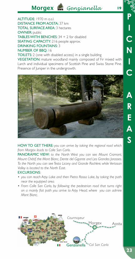
Morgex Genzianella 19
ALTITuDe: 1970 m o.s.l.DIsTANCe FROM AOsTA: 37 kmTOTAL suRFACe AReA: 3 hectaresOWNeR: publicTABLes WITH BeNCHes: 34 + 2 for disabledseATING CApACITY: 216 people approx.DRINKING FOuNTAINs: 3NuMBeR OF BBq: 16TOILeTs: 2 (one with disabled access) in a single buildingVeGeTATION: mature woodland mainly composed of Fir mixed with Larch and individual specimens of Scottish Pine and Swiss Stone Pine. Presence of Juniper in the undergrowth.
HOW TO GeT THeRe: you can arrive by taking the regional road which from Morgex leads to Colle San Carlo.pANORAMIC VIeW: to the North West you can see Mount Cramont, Mount Chétif, the Mont Blanc, Dente del Gigante and Les Grandes Jorasses. To the North you can see Testa Licony and Grande Rochère; while Vertosan Valley is located to the North East.eXCuRsIONs:
you can reach Arpy Lake and then Pietra Rossa Lake, by taking the path • near the equipped area.From Colle San Carlo, by following the pedestrian road that turns right • on a mainly flat path you arrive to Arpy Head, where you can admire Mont Blanc.
Courmayeur
Col San CarloGenzianella
Morgex Aosta
PICNIC
AREAS
24
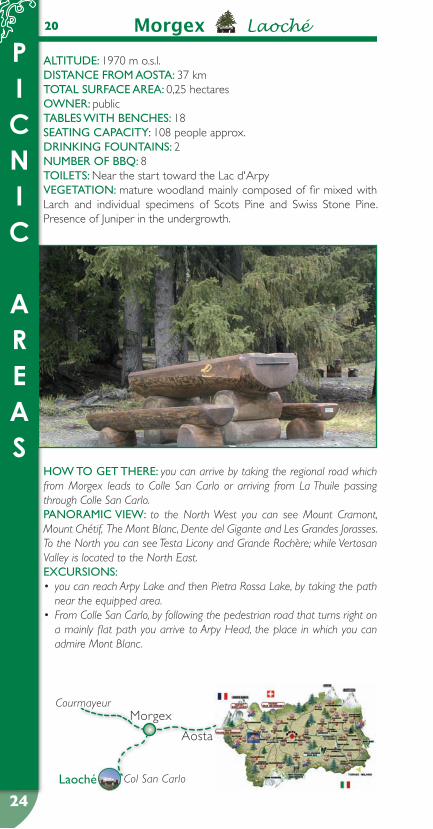
Morgex Laoché 20
ALTITuDe: 1970 m o.s.l.DIsTANCe FROM AOsTA: 37 kmTOTAL suRFACe AReA: 0,25 hectaresOWNeR: publicTABLes WITH BeNCHes: 18seATING CApACITY: 108 people approx.DRINKING FOuNTAINs: 2NuMBeR OF BBq: 8TOILeTs: Near the start toward the Lac d'ArpyVeGeTATION: mature woodland mainly composed of fir mixed with Larch and individual specimens of Scots Pine and Swiss Stone Pine. Presence of Juniper in the undergrowth.
HOW TO GeT THeRe: you can arrive by taking the regional road which from Morgex leads to Colle San Carlo or arriving from La Thuile passing through Colle San Carlo.pANORAMIC VIeW: to the North West you can see Mount Cramont, Mount Chétif, The Mont Blanc, Dente del Gigante and Les Grandes Jorasses. To the North you can see Testa Licony and Grande Rochère; while Vertosan Valley is located to the North East. eXCuRsIONs:
you can reach Arpy Lake and then Pietra Rossa Lake, by taking the path • near the equipped area.From Colle San Carlo, by following the pedestrian road that turns right on • a mainly flat path you arrive to Arpy Head, the place in which you can admire Mont Blanc.
Courmayeur
Col San CarloLaoché
Morgex
Aosta

PICNIC
AREAS
25
Morgex Plan Capé 21
ALTITuDe: 1930 m o.s.l.DIsTANCe FROM AOsTA: 35 kmTOTAL suRFACe AReA: 0,65 hectaresOWNeR: publicTABLes WITH BeNCHes: 16 + 1 for disabledseATING CApACITY: 102 people approx.DRINKING FOuNTAINs: 2NuMBeR OF BBq: 9TOILeTs: 3 (one with disabled access) in a single buildingVeGeTATION: mature woodland mainly composed of Fir mixed with Larch and individual specimens of Scots Pine, Swiss Stone Pine and Silver Fir. Presence of Juniper in the undergrowth.
HOW TO GeT THeRe: you can arrive by taking the regional road which from Morgex leads to Colle San Carlo or arriving from La Thuile passing through Colle San Carlo.pANORAMIC VIeW: the area is immerged in woodland greenery com-posed mainly of Fir and Larch.eXCuRsIONs: starting from the area you can reach Arpy village, the departure point of numerous excursions.
Courmayeur
Col San Carlo
plan Capé
Morgex Aosta

PICNIC
AREAS
26
Nus Porliod22
ALTITuDe: 1900 m o.s.l.DIsTANCe FROM AOsTA: 32 kmTOTAL suRFACe AReA: 0,3 hectaresOWNeR: public and privateTABLes WITH BeNCHes: 10 + 2 for disabledseATING CApACITY: 72 people approx.DRINKING FOuNTAINs: 2NuMBeR OF BBq: 8TOILeTs: 3 (one with disabled access) in a single buildingVeGeTATION: typical Alpine vegetation consisting of Larch and xerophilous bushes like Barberry, Sloe and Wild Rose.
HOW TO GeT THeRe: from Nus you take the main regional road as far as the village of Lignan, then continue along the local road approximately 3 km until arriving at Porliod.pANORAMIC VIeW: to the north-east you can see Cima Longhede and then Becca d’Aver and Mont Méabé that separates the Torgnon district; to the west you can enjoy views over the lower valley and the valleys of Clavalité, Saint-Marcel, Les Laures with Mont-Emilius and the district of Pila.eXCuRsIONs: the footpath signposts near the area indicate paths 11B and 11C which direct you to the refuge and oratory of Cuney, whereas path no. 14 leads to the Sanctuary of Champlaisant, following the cross-country skiing track. Lastly there is a sign indicating part of the Intervalley Itinerary no.105 which starts from Aosta, in the village of Porossan, and ends in the town of Gressoney-Saint-Jean, at the Colle Valdobbia.
Aosta
Nus
Saint-Barthélemy
porliod
PICNIC
AREAS
27
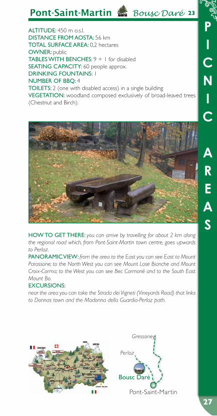
Pont-Saint-Martin Bousc Daré 23
ALTITuDe: 450 m o.s.l.DIsTANCe FROM AOsTA: 56 kmTOTAL suRFACe AReA: 0,2 hectaresOWNeR: publicTABLes WITH BeNCHes: 9 + 1 for disabledseATING CApACITY: 60 people approx.DRINKING FOuNTAINs: 1NuMBeR OF BBq: 4TOILeTs: 2 (one with disabled access) in a single buildingVeGeTATION: woodland composed exclusively of broad-leaved trees (Chestnut and Birch).
HOW TO GeT THeRe: you can arrive by travelling for about 2 km along the regional road which, from Pont-Saint-Martin town centre, goes upwards to Perloz.pANORAMIC VIeW: from the area to the East you can see East to Mount Parassone; to the North West you can see Mount Lose Bianche and Mount Croix-Corma; to the West you can see Bec Cormoné and to the South East Mount Bo.eXCuRsIONs: near the area you can take the Strada dei Vigneti (Vineyards Road) that links to Donnas town and the Madonna della Guardia-Perloz path.
Gressoney
Perloz
Bousc Daré
Pont-Saint-Martin
PICNIC
AREAS
28
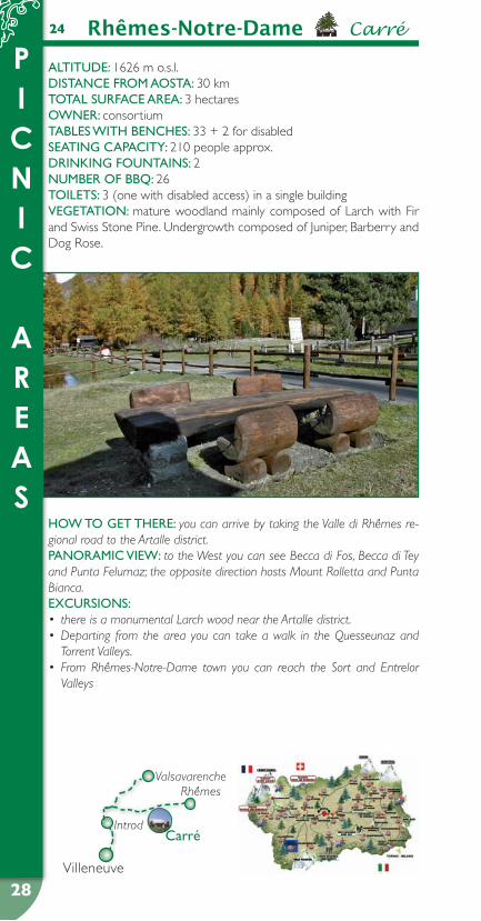
Rhêmes-Notre-Dame Carré24
ALTITuDe: 1626 m o.s.l.DIsTANCe FROM AOsTA: 30 kmTOTAL suRFACe AReA: 3 hectaresOWNeR: consortium TABLes WITH BeNCHes: 33 + 2 for disabledseATING CApACITY: 210 people approx.DRINKING FOuNTAINs: 2NuMBeR OF BBq: 26TOILeTs: 3 (one with disabled access) in a single buildingVeGeTATION: mature woodland mainly composed of Larch with Fir and Swiss Stone Pine. Undergrowth composed of Juniper, Barberry and Dog Rose.
HOW TO GeT THeRe: you can arrive by taking the Valle di Rhêmes re-gional road to the Artalle district.pANORAMIC VIeW: to the West you can see Becca di Fos, Becca di Tey and Punta Felumaz; the opposite direction hosts Mount Rolletta and Punta Bianca.eXCuRsIONs:
there is a monumental Larch wood near the Artalle district.• Departing from the area you can take a walk in the Quesseunaz and • Torrent Valleys.From Rhêmes-Notre-Dame town you can reach the Sort and Entrelor • Valleys
Introd
ValsavarencheRhêmes
Carré
Villeneuve

PICNIC
AREAS
29
Saint-Marcel Les Druges 25
ALTITuDe: 1600 m o.s.l.DIsTANCe FROM AOsTA: 26 kmTOTAL suRFACe AReA: 1,2 hectaresOWNeR: publicTABLes WITH BeNCHes: 26 + 2 for disabledseATING CApACITY: 168 people approx.DRINKING FOuNTAINs: 3NuMBeR OF BBq: 12TOILeTs: 2 (one with disabled access) in a single buildingVeGeTATION: mature woodland mainly composed of Fir mixed with Larch and some specimens of Scots Pine, Swiss Stone Pine and Silver Fir. Presence of Juniper and Rhododendron in the undergrowth.
HOW TO GeT THeRe: you can arrive by taking the regional road leading up to Saint-Marcel, which arrives to the Les Druges district.pANORAMIC VIeW: from the equipped area, to the South and to the South West you can see Mount Corquet, Becca di Salé and Punta Plan Rué.eXCuRsIONs:
you can reach Mount Corquet by taking the path departing from the Les • Druges district. Follow the path going East to reach Maison Blanche and then, from here, continue onwards to Clavalité Valley.Turning West, you can reach the old mines, up to Saint-Marcel Valley.•
Aosta
Saint-Marcel
Seissogne
Les Druges
PICNIC
AREAS
30
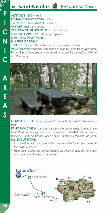
Saint-Nicolas Bois de la Tour26
ALTITuDe: 1200 m o.s.l.DIsTANCe FROM AOsTA: 17 kmTOTAL suRFACe AReA: 1,6 hectaresOWNeR: public and privateTABLes WITH BeNCHes: 28 + 1 for disabledseATING CApACITY: 170 people approx.DRINKING FOuNTAINs: 2NuMBeR OF BBq: 7TOILeTs: 2 (one with disabled access) in a single buildingVeGeTATION: woodland composed of mature Larch trees with some Fir and Birch. Undergrowth composed of Juniper, Barberry, Goat Willow and Bearberry.
HOW TO GeT THeRe: easy to reach, due to its proximity to Saint-Nicolas town.pANORAMIC VIeW: the area overlooks the central valley. Starting in the South West and looking South you can see Becca del Merlo, Mount Grivola, Punta del Gran "Nomenon;” while Mount Emilius is located to the South East.eXCuRsIONs:
from the Bois de la Tour through the vineyards of the "Enfer" you can reach • the village of Arvier.From Saint-Nicolas you can walk toward the village of Vens and from here • you continue to the Vertosan's combe.
Saint-Nicolas
Bois de la Tour
Saint-PierreAosta
Courmayeur
PICNIC
AREAS
31
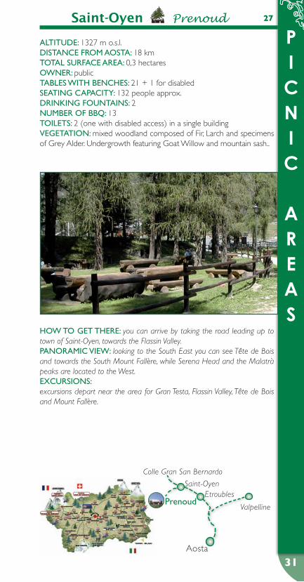
27Saint-Oyen Prenoud
ALTITuDe: 1327 m o.s.l.DIsTANCe FROM AOsTA: 18 kmTOTAL suRFACe AReA: 0,3 hectaresOWNeR: publicTABLes WITH BeNCHes: 21 + 1 for disabledseATING CApACITY: 132 people approx.DRINKING FOuNTAINs: 2NuMBeR OF BBq: 13TOILeTs: 2 (one with disabled access) in a single buildingVeGeTATION: mixed woodland composed of Fir, Larch and specimens of Grey Alder. Undergrowth featuring Goat Willow and mountain sash..
HOW TO GeT THeRe: you can arrive by taking the road leading up to town of Saint-Oyen, towards the Flassin Valley.pANORAMIC VIeW: looking to the South East you can see Tête de Bois and towards the South Mount Fallère, while Serena Head and the Malatrà peaks are located to the West.eXCuRsIONs: excursions depart near the area for Gran Testa, Flassin Valley, Tête de Bois and Mount Fallère.
Valpelline
EtroublesSaint-Oyen
Colle Gran San Bernardo
prenoud
Aosta
PICNIC
AREAS
32
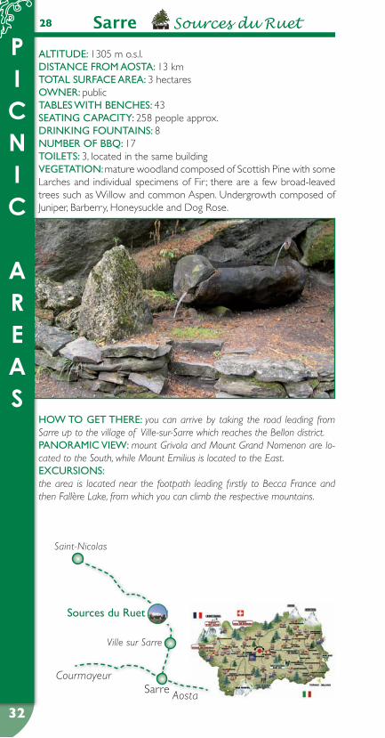
Sarre Sources du Ruet28
ALTITuDe: 1305 m o.s.l.DIsTANCe FROM AOsTA: 13 kmTOTAL suRFACe AReA: 3 hectaresOWNeR: publicTABLes WITH BeNCHes: 43seATING CApACITY: 258 people approx.DRINKING FOuNTAINs: 8NuMBeR OF BBq: 17TOILeTs: 3, located in the same buildingVeGeTATION: mature woodland composed of Scottish Pine with some Larches and individual specimens of Fir ; there are a few broad-leaved trees such as Willow and common Aspen. Undergrowth composed of Juniper, Barberry, Honeysuckle and Dog Rose.
HOW TO GeT THeRe: you can arrive by taking the road leading from Sarre up to the village of Ville-sur-Sarre which reaches the Bellon district.pANORAMIC VIeW: mount Grivola and Mount Grand Nomenon are lo-cated to the South, while Mount Emilius is located to the East.eXCuRsIONs: the area is located near the footpath leading firstly to Becca France and then Fallère Lake, from which you can climb the respective mountains.
Saint-Nicolas
Ville sur Sarre
sources du Ruet
Sarre Aosta
Courmayeur

PICNIC
AREAS
33
Torgnon Chantorné 29
ALTITuDe: 1765 m o.s.l.DIsTANCe FROM AOsTA: 40 kmTOTAL suRFACe AReA: 3,5 hectaresOWNeR: publicTABLes WITH BeNCHes: 57 + 3 for disabledseATING CApACITY: 360 people approx.DRINKING FOuNTAINs: 4NuMBeR OF BBq: 28TOILeTs: 5, in 2 separate buildings (both with disabled access)VeGeTATION: wood composed of mature Fir and Larch trees. Undergrowth composed of Fern, Elderberry, Dog Rose and Raspberry.
HOW TO GeT THeRe: you can arrive by taking the public road which from the main town goes up to Chatelard village, and then toward the Chantorné district.pANORAMIC VIeW: towards the East you can see Mount Tantané and Mount Zerbion, while Mount Méabé, Col Fenêtre and Becca d’Aver are located in the opposite direction.eXCuRsIONs: by taking the path which from Torgnon goes up to Becca d’Aver you can reach Longhède Summit, Col Fenêtre and then Saint Barthélemy Valley, Praz Valley or go up to Mount Méabé.
Châtillon
Col San Pantaleone
Antey-Saint-André
Torgnon
Breuil-CerviniaChantorné
PICNIC
AREAS
34
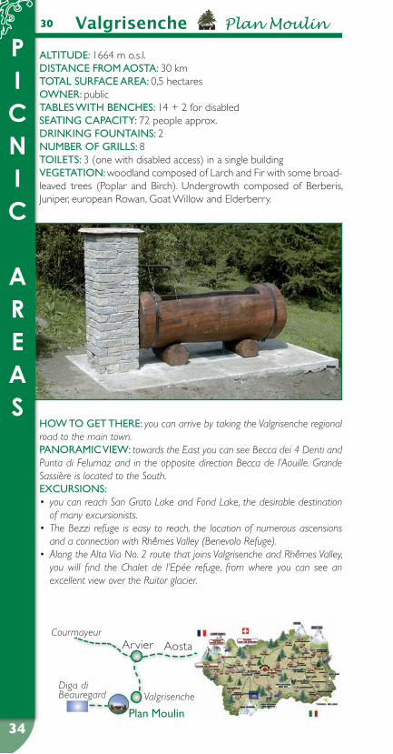
Valgrisenche Plan Moulin30
ALTITuDe: 1664 m o.s.l.DIsTANCe FROM AOsTA: 30 kmTOTAL suRFACe AReA: 0,5 hectaresOWNeR: publicTABLes WITH BeNCHes: 14 + 2 for disabledseATING CApACITY: 72 people approx.DRINKING FOuNTAINs: 2NuMBeR OF GRILLs: 8TOILeTs: 3 (one with disabled access) in a single buildingVeGeTATION: woodland composed of Larch and Fir with some broad-leaved trees (Poplar and Birch). Undergrowth composed of Berberis, Juniper, european Rowan, Goat Willow and Elderberry.
HOW TO GeT THeRe: you can arrive by taking the Valgrisenche regional road to the main town.pANORAMIC VIeW: towards the East you can see Becca dei 4 Denti and Punta di Felumaz and in the opposite direction Becca de l’Aouille. Grande Sassière is located to the South.eXCuRsIONs:
you can reach San Grato Lake and Fond Lake, the desirable destination • of many excursionists.The Bezzi refuge is easy to reach, the location of numerous ascensions • and a connection with Rhêmes Valley (Benevolo Refuge).Along the Alta Via No. 2 route that joins Valgrisenche and Rhêmes Valley, • you will find the Chalet de l’Epée refuge, from where you can see an excellent view over the Ruitor glacier.
Courmayeur
Diga di Beauregard Valgrisenche
Arvier Aosta
plan Moulin
PICNIC
AREAS
35
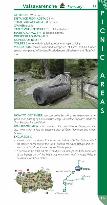
Valsavarenche Foncey 31
ALTITuDe: 1690 m o.s.l.DIsTANCe FROM AOsTA: 33 kmTOTAL suRFACe AReA: 1,8 hectaresOWNeR: publicTABLes WITH BeNCHes: 25 + 1 for disabledseATING CApACITY: 156 people approx.DRINKING FOuNTAINs: 3NuMBeR OF BBq: 17TOILeTs: 3 (one with disabled access) in a single buildingVeGeTATION: mixed woodland composed of Larch and Fir. Under-growth composed of Juniper, Rhododendron, Blueberry and Goat Wil-low.
HOW TO GeT THeRe: you can arrive by taking the Valsavarenche re-gional road, passing by Eaux Rousses village. This district is located inside the Gran Paradiso National Park.pANORAMIC VIeW: you can admire the Gran Paradiso Massif and Dé-gioz town which enjoys an excellent view of Gran Nomenon and Mount Grivola.eXCuRsIONs:
you can reach the Vittorio Emanuele and Federico Chabod Refuges which • are located at the foot of the Gran Paradiso, the Savoy Refuge and Chi-
vasso town's refuge located on the Nivolet plane.A section of the "Alta Via No.2" road passes through the Col Lauzon, one • of the highest part of the Hight way mountains roads in Aosta Valley at an altitude of 3,296 metres.
Introd
Valsavarenche
Rhêmes
Pont
Foncey
Villeneuve

PICNIC
AREAS
36
ALTITuDe: 2000 m o.s.l.DIsTANCe FROM AOsTA: 50 kmTOTAL suRFACe AReA: 1,9 hectaresOWNeR: publicTABLes WITH BeNCHes: 27seATING CApACITY: 162 people approx.DRINKING FOuNTAINs: 4NuMBeR OF GRILLs: 10TOILeTs: 3 (one with disabled access) in a single buildingVeGeTATION: woodland mainly composed of Larch with a green Alder maquis. Undergrowth composed of Rhododendrons and Blueberry.
HOW TO GeT THeRe: you can arrive by taking the Valtournenche re-gional road near the town of Breuil.AReA pANORAMA: towards the West you can admire the Grandes Mu-railles mountain chain, while to the North the impressive “La Gran Becca”: the Matterhorn.eXCuRsIONs: from the area you can climb a short path to the village of Cielo Alto; or, for those of you in search of longer routes, you can reach Bec del Merlo or Goillet Lake.
Valtournenche Breuil 32
Châtillon
Antey-Saint-André
Torgnon
Breuil-Cervinia
ValtournencheBreuil

PICNIC
AREAS
37
Valtournenche Champlève 33
ALTITuDe: 1841 m o.s.l.DIsTANCe FROM AOsTA: 46 kmTOTAL suRFACe AReA: 1 hectaresOWNeR: publicTABLes WITH BeNCHes: 24 + 1 for disabledseATING CApACITY: 150 people approx.DRINKING FOuNTAINs: 2NuMBeR OF BBq: 6TOILeTs: 3 (one with disabled access) in a single buildingVeGeTATION: sparse and sporadic woodland composed of mature Larch with alternating Green Alder trees and fields. Undergrowth com-posed of Juniper and Rhododendrons.
HOW TO GeT THeRe: you can arrive by taking the road that leads from Valtournenche the tour of to the Cheneil district.pANORAMIC VIeW: to the North West you can see Les Grandes Mu-railles, Château des Dames and Punta Tzan, while to the North East you can see the Cime Bianche, and the Matterhorn to the North.eXCuRsIONs:
departing from the Cheneil district you can reach Chamois town by cros-• sing the Gran Balconata route or by following the path leading to Clavalité
Sanctuary.Again, departing from the Cheneil district you can also make excursions • to Becca d’Aran, Petit and Grand Tournalin and Col di Nana by following the Alta Via No. 1 track.
Châtillon
Antey-Saint-André
Torgnon
Breuil-Cervinia
ValtournencheChamplève
PICNIC
AREAS
38
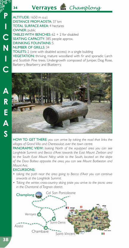
34 Verrayes Champlong
ALTITuDe: 1650 m o.s.l.DIsTANCe FROM AOsTA: 37 kmTOTAL suRFACe AReA: 4 hectaresOWNeR: publicTABLes WITH BeNCHes: 62 + 2 for disabledseATING CApACITY: 385 people approx.DRINKING FOuNTAINs: 5NuMBeR OF GRILLs: 34TOILeTs: 2 (one with disabled access) in a single buildingVeGeTATION: thriving, mature woodland with fir and sporadic Larch and Scottish Pine trees. Undergrowth composed of Juniper, Dog Rose, Barberry, Bearberry and Blueberry.
HOW TO GeT THeRe: you can arrive by taking the road that links the villages of Grand Villa and Cheresoulaz, over the town centre.pANORAMIC VIeW: looking North of the equipped area you can see Longhède Summit and Becca d’Aver, towards the East Mount Zerbion and to the South East Mount Néry; while to the South, located on the slope of the Dora Baltea opposite the area, you can see Mount Barbeston and Mount Avic.eXCuRsIONs:
taking the path near the area going to Becca d’Aver you can continue • onwards at the Longhède Summit.Taking the winter, cross-country skiing piste you arrive to the picnic area • in the Chantorné di Torgnon district.
Verrayes
Saint-Denis
Champlong
ChambaveSaint-Vincent
Aosta
Col San Pantaleone
ANTEY-SAINT-ANDRÉ
CHAMPDEPRAZ
COURMAYEUR
FONTAINEMORE
LA MAGDELEINE
MORGEX
SAINT-NICOLAS
TORGNON
VALTOURNENCHE
ACTIVITYPATHS

4040
2
ACTIVITY
PATHS
1
Antey-Saint-André?
Antey-Saint-André (for disabled)
ALTITuDe: 1080 m o.s.l.DIsTANCe FROM AOsTA: 32 kmOWNeR: publicLeNGTH OF ROuTe: 1600 mNuMBeR OF sTOps: 21VeGeTATION: mixed white-wood forest with prevalence of Fir and Larch, occasional hardwood including service, hazel and downy oak. LOCATION: take the local road leading from Antey-Saint-André to the artificial rock climbing wall.
ALTITuDe: 1000 m o.s.l.DIsTANCe FROM AOsTA: 31 kmOWNeR: public and privateLeNGTH OF ROuTe: 1280 mNuMBeR OF sTOps: 9VeGeTATION: typical mountain plain woodland which thins out at inter-vals along the path, leaving space for clearings cultivated with permanent meadow. Species in the hardwood coppice are Ash, Alder, Maple, Lime, Birch, goat Willow, with occasional Larch and Scottish pine. LOCATION: leaving the village of Antey-Saint-André, follow the regional road to La Magdeleine for about 50 m until you reach the beginning of the route.
41
ACTIVITY
PATHS
41
3
3
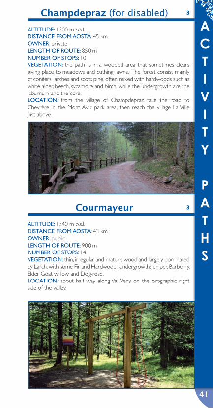
Courmayeur
Champdepraz (for disabled)
ALTITuDe: 1540 m o.s.l.DIsTANCe FROM AOsTA: 43 kmOWNeR: publicLeNGTH OF ROuTe: 900 mNuMBeR OF sTOps: 14VeGeTATION: thin, irregular and mature woodland largely dominated by Larch, with some Fir and Hardwood. Undergrowth: Juniper, Barberry, Elder, Goat willow and Dog-rose.LOCATION: about half way along Val Veny, on the orographic right side of the valley.
ALTITuDe: 1300 m o.s.l.DIsTANCe FROM AOsTA: 45 kmOWNeR: privateLeNGTH OF ROuTe: 850 mNuMBeR OF sTOps: 10VeGeTATION: the path is in a wooded area that sometimes clears giving place to meadows and cuthing lawns. The forest consist mainly of conifers, larches and scots pine, often mixed with hardwoods such as white alder, beech, sycamore and birch, while the undergrowth are the laburnum and the core.LOCATION: from the village of Champdepraz take the road to Chevrère in the Mont Avic park area, then reach the village La Ville just above.
4242
ACTIVITY
PATHS
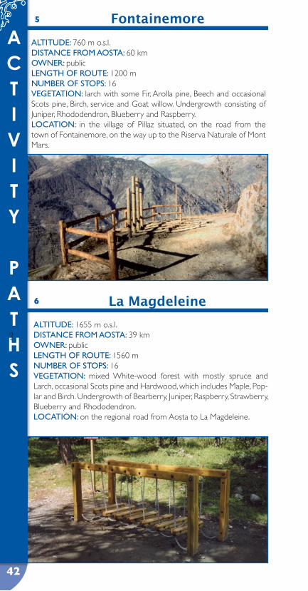
La Magdeleine6
?ALTITuDe: 1655 m o.s.l.DIsTANCe FROM AOsTA: 39 kmOWNeR: publicLeNGTH OF ROuTe: 1560 mNuMBeR OF sTOps: 16VeGeTATION: mixed White-wood forest with mostly spruce and Larch, occasional Scots pine and Hardwood, which includes Maple, Pop-lar and Birch. Undergrowth of Bearberry, Juniper, Raspberry, Strawberry, Blueberry and Rhododendron.LOCATION: on the regional road from Aosta to La Magdeleine.
5 Fontainemore
ALTITuDe: 760 m o.s.l.DIsTANCe FROM AOsTA: 60 kmOWNeR: publicLeNGTH OF ROuTe: 1200 mNuMBeR OF sTOps: 16VeGeTATION: larch with some Fir, Arolla pine, Beech and occasional Scots pine, Birch, service and Goat willow. Undergrowth consisting of Juniper, Rhododendron, Blueberry and Raspberry.LOCATION: in the village of Pillaz situated, on the road from the town of Fontainemore, on the way up to the Riserva Naturale of Mont Mars.
43
ACTIVITY
PATHS
43
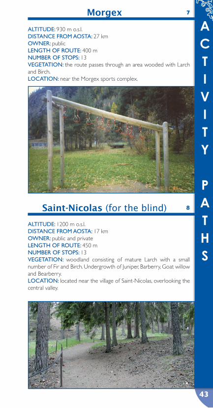
Saint-Nicolas (for the blind) 8
Morgex 7
ALTITuDe: 930 m o.s.l.DIsTANCe FROM AOsTA: 27 kmOWNeR: publicLeNGTH OF ROuTe: 400 mNuMBeR OF sTOps: 13VeGeTATION: the route passes through an area wooded with Larch and Birch.LOCATION: near the Morgex sports complex.
ALTITuDe: 1200 m o.s.l.DIsTANCe FROM AOsTA: 17 kmOWNeR: public and privateLeNGTH OF ROuTe: 450 mNuMBeR OF sTOps: 13VeGeTATION: woodland consisting of mature Larch with a small number of Fir and Birch. Undergrowth of Juniper, Barberry, Goat willow and Bearberry.LOCATION: located near the village of Saint-Nicolas, overlooking the central valley.
4444
ACTIVITY
PATHS
10 Valtournenche (Maen)
ALTITuDe: 1310 m o.s.l.DIsTANCe FROM AOsTA: 39 kmOWNeR: CVA (electricity company), granted for use to municipalityLeNGTH OF ROuTe: 900 mNuMBeR OF sTOps: 14VeGeTATION: mixed woodland consisting of mature Fir and Larch. There are occasional Scottish pine and Stone pine. The hardwood con-sists of Birch, Maple and Ash. Along the stream and marchy areas can be found Alder and Willow. Undergrowth: Fern, Elder, Blueberry, Dog-rose and Raspberry.LOCATION: the village of Maen, on the regional Valtournenche road.
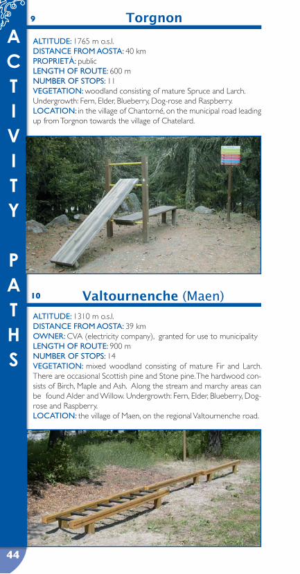
9 Torgnon
ALTITuDe: 1765 m o.s.l.DIsTANCe FROM AOsTA: 40 kmpROpRIeTà: publicLeNGTH OF ROuTe: 600 mNuMBeR OF sTOps: 11VeGeTATION: woodland consisting of mature Spruce and Larch. Undergrowth: Fern, Elder, Blueberry, Dog-rose and Raspberry.LOCATION: in the village of Chantorné, on the municipal road leading up from Torgnon towards the village of Chatelard.
45
ACTIVITY
PATHS
45
Valtournenche (Cré-du-Pont)
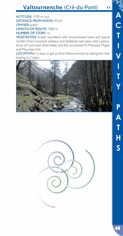
ALTITuDe: 1530 m o.s.l.DIsTANCe FROM AOsTA: 45 kmOWNeR: publicLeNGTH OF ROuTe: 1000 mNuMBeR OF sTOps: 16VeGeTATION: mixed woodland with broad-leaved trees and typical conifers from mountain plateaus and sheltered wet areas with a preva-lence of Larch and white Alder and the occasional Fir, Mountain Maple and Mountain Ash.LOCATION: it is easy to get to from Valtournenche by taking the road leading to Crepin.
11
45

46
U S E F U L N U M B E R S
FOREST SERVICE STATIONS
pRé-sAINT-DIDIeR 0165 867223ARVIeR 0165 929801VILLeNeuVe 0165 95026AYMAVILLes 0165 923006AOsTA 0165 231185VALpeLLINe 0165 73238eTROuBLes 0165 78204Nus 0165 767921CHâTILLON 0166 563265ANTeY-sAINT-ANDRé 0166 548235VeRRès 0125 921005BRussON 0125 300145pONT-sAINT-MARTIN 0125 806858GABY 0125 345940
DepARTMeNT FOR pLANT AND ANIMAL LIFe, HuNTING AND FIsHING 0165 776220
• 112 CARABINIeRI• 113 pOLICe• 115 FIRe seRVICe• 117 CusTOMs OFFICeR• 118 MeDICAL HeLp• 1515 FOResT RANGeRs• 800 319 319 CIVIL DeFeNCe• 800 800 319 MOuNTAIN ResCue
WeATHeR CONDITIONs AND FOReCAsTING:FOR WeATHeR RepORT pHONe 0165 272333www.regione.vda.it/territorio/centrofunzionale/meteo
47
U S E F U L N U M B E R S
MUNICIPALITIES
ANTeY-sAINT-ANDRé 0166 548209AVIse 0165 91113AYAs 0125 306632BIONAZ 0165 730106BRussON 0125 300132CHAMOIs 0166 47134CHAMpDepRAZ 0125 960692 CHAMpORCHeR 0125 37106COGNe 0165 753800COuRMAYeuR 0165 831311DONNAs 0125 807051/804728DOues 0165 738042éMARèse 0166 519103FéNIs 0165 769869FONTAINeMORe 0125 832121GRessONeY-LA-TRINITé 0125 366137/366060IssIMe 0125 344033LA MAGDeLeINe 0166 548274LA sALLe 0165 861908/861912LA THuILe 0165 884108MORGeX 0165 801711Nus 0165 763763pONT-sAINT-MARTIN 0125 830611RHÊMes-NOTRe-DAMe 0165 936162/936114sAINT-MARCeL 0165 768801sAINT-NICOLAs 0165 908814sAINT-OYeN 0165 78522sARRe 0165 215611TORGNON 0166 540213VALGRIseNCHe 0165 97105VALsAVAReNCHe 0165 905703VALTOuRNeNCHe 0166 946811VeRRAYes 0166 43106
48
TOURIST OFFICES
Tourist office - AOsTA
tel 0165.236627
Tourist office - GRessONeY-LA-TRINITé tel 0125.366143
Tourist office - pONT-sAINT-MARTIN tel 0125.804843
Tourist office - AYAs CHAMpOLuC tel 0125.307113
Tourist office - BRussON tel 0125.300240
Tourist office - BReuIL - CeRVINIA tel 0166.949136
Tourist office - VALTOuRNeNCHe tel 0166.92029
Tourist office - ANTeY-sAINT-ANDRé tel 0166.548266
Tourist office - sAINT-VINCeNT
tel 0166.511335
Tourist office - eTROuBLes
tel 0165.78559
Tourist office - VALpeLLINe (open seasonally) tel 0165.713502
Tourist office - COGNe tel 0165.74040
Tourist office - COuRMAYeuR tel 0165.842060
Tourist office - LA THuILe
tel 0165.884179
U S E F U L N U M B E R S

RESPECT NATURE,
LEARN HOW TO RECOGNISE AND OBSERVE IT
HELP US TO PRESERVE THE AREA
The equipped area is a space to be used by tourists. It has the following services: car park, drinking water fountains, tables and benches, barbecues and toilets.
This area is equipped for your use, but:
please do not ride bikes, motorbikes or vehicles across it, as this will damage the grass: please leave all means of transport in the car parking spaces provided;
please use the barbecues provided in order to prevent potentially dangerous fires;
please use the available firewood and embers in the barbecue, leaving the trees and fencing as they are;
please do not interfere with the natural environment: cutting trees and uprooting plants and flowers damages and disturbs the natural environment;
please remember that leaving rubbish behind degrades the area, as well as creating a source of infection for people and particularly children;
please remember to respect everything that is provided for everyone’s use. By using common sense and care, we can enjoy nature’s spaces better;
please learn to respect nature’s silence by not polluting the natural environment with shouting, loud radios or other unnecessarily loud noises.
R U L E S O F C O N D U C T
Aree attrezzate
Percorsi attrezzati