planning, design and development item d2 for september 2, …
TRANSCRIPT

Flower City
Report Planning, Design & Development Committee
Standing Committee of the Council
of the Corporation of the City of Brampton
DATE: September 02, 2009 PLANNING, DESIGN & DEVELOPMENT COMMITTEE
FILE: City File: C05E03.014
SUBJECT: INFORMATION REPORT
Application to Amend the Official Plan and Zoning By-Law
to Permit Condominium Townhouses
HABITAT FOR HUMANITY BRAMPTON
Located west of Torbram Road and south of Clark
Boulevard.
Plan- PLAN 817 BLKC
Ward: 8
Contact: Kathy Ash 905-874-2067
OVERVIEW:
• Habitat for Humanity Brampton has filed an application to amend the
Official Plan and Zoning By-Law to permit the development of
townhouses on lands located on the west side of Torbram Road South
of Clark Boulevard.
• The subject lands were declared as surplus lands by the City of
Brampton and made available to Habitat for Humanity to proceed
through the required Official Plan and Zoning amendment process.
• Habitat for Humanity Brampton is proposing to build 18 residential
units in the form of 'stacked townhouses', 3 storeys in height.
• The current conceptual site plan shows two separate buildings centred by a play area and parking spaces.
4b Information Report

Recommendations:
1. THAT the report from Kathy Ash, Manager of Development Services, and
Paul Aldunate, Development Planner, Planning Design and Development
Department, entitled "Application to Amend the Official Plan and Zoning
By-Law - HABITAT FOR HUMANITY BRAMPTON" dated September 02,
2009 be received; and,
2. THAT staff be directed to report back to Planning, Design and
Development Committee with the results of the Public Meeting and a staff
recommendation, subsequent to the completion of the circulation of the
application and a comprehensive evaluation of the proposal.
BACKGROUND:
Proposal:
Habitat for Humanity Brampton is proposing to build 18 residential units in the
form of stacked townhouses, 3 storeys in height. The applicant is proposing two
separate buildings with nine units in each. The conceptual site plan shows a
central play area and parking spaces, with one building backing onto the Mimico
Creek and the second running perpendicular to Torbram Road. A total of 18
parking spaces are proposed.
The applicant is proposing vehicular access from Torbram Road.
Property Description and Surrounding Land Use:
The subject property has the following characteristics:
♦ is located on the west side of Torbram Road south of Clark Boulevard
♦ has a site area of 0.92 acres (.37 hectares)
♦ is surplus land from the abutting parkland and open space lands
The surrounding land uses are described as follows:
North: An existing residential condominium townhouse development
South: An existing industrial/commercial condominium development
East: Torbram Road, beyond which are industrial/manufacturing and
warehousing businesses.
West: Open space and a tributary of Mimico Creek, beyond which are
existing high-rise residential apartments.
4b Information Report

LOCATION
MAP
AERIAL
SCALE
1:
5,000
AERIAL
DATE:
FALL
2009
c>
MAP
2 -AERIAL
AND
LOCATION
MAP
HABITAT
FOR
HUMANITY
*
City
of
Brampton
CITY
FILE:
C05E03.0U
MOWER
CUV
y|
PLANNING,
I
DESIGN
&
^DEVELOPMENT
Da
te: 20
09 0401
Map
No.
64-34
Drawn
Bv
CJK

FLOWER CITY
PLANNING,
DESIGN &
DEVELOPMENT
MAP 1 - DRAFT CONCEPT SITE HABITAT FOR HUMANITY City of Brampton
PLAN
BRAHPTDN.CA
CITY FILE: C05E03.014
Dale: 2009 08 11 Drawn By: CJK

CURRENT SITUATION:
Origin:
Official Plan:
Secondary Plan:
Zoning By-law:
Proposed Servicing:
Agency Comments
Received:
INFORMATION SUMMARY
Date Submitted: October 29, 2003
Owner: HABITAT FOR HUMANITY
BRAMPTON
The subject lands are designated as part of the
'Open Space1 system in the Official Plan. The
current designation does not permit residential uses.
The purpose of the subject application is to
redesignate all the lands to "Residential".
The subject lands are designated as 'Parks and
Open Space' in the Southgate Secondary Plan
(SP21). The current designation does not permit
residential uses. An Official Plan amendment is also
required.
The subject lands are zoned as Open Space - OS
by By-Law 270-2004, as amended. The current
zoning designation does not permit residential uses.
The applicant has applied to rezone the subject
property.
The applicant is proposing access to existing
municipal sanitary sewer and watermains.
The application has been circulated to internal and
external departments and agencies. Complete
comments/conditions received will be provided
within the forthcoming Recommendation Report.
4b Information Report

INFORMATION SUMMARY
Region of Peel:
Growth Management:
Urban Design:
Heritage Impact:
Comments from the Region of Peel indicate that
there is a 300mm diameter watermain in an
easement at the north end of the property. The
applicant is advised that any Regional easements
must be protected from any encroachments or
obstructions. The applicant has proposed a
driveway in the area of the required easement,
which according to the Region of Peel is not an
obstruction.
The applicant must provide sufficient turnaround
space for waste collection vehicles. Revised site
plans will need to be provided in this regard.
Given the current configuration, a common collection
area will be needed in order to provide waste
collection services to the westerly structure.
Complete comments and recommendations with
respect to the timing of this proposal within the
context of the City's Growth Management Program
will be provided in the Recommendation Report.
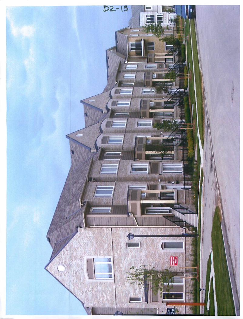
The end unit abutting Torbram Road should have
superior architecture that addresses the street.
A landscape strip and a chain link fence should be
provided along the northern portion of the site
abutting the existing condominium residential
development.
Appendix 5 provides some conceptual elevations
that Habitat for Humanity is considering for the site.
No heritage resources have been identified on the site.
4b Information Report

-7
INFORMA TION SUMMA Ft Y
Documents Submitted in
Support of Application:
Outstanding Issues:
Public Meeting
Notification Area:
Respectfully submitted:
• Draft Zoning By-law
• Conceptual Site Plan
• Planning Rationale Letter
Issues to consider through the review of this
application include:
• A review of parking standards and what is the
appropriate amount of parking for future
residents.
• The interface treatment between these lands
and the existing industrial/commercial to the
south and the existing residents to the north.
Notice of the Public Meeting was given by prepaid
first class mail to all persons assessed in respect of
land to which the proposal applies and within 800
metres of the area to which the proposal applies as
shown on the last revised assessment roll, and by
public notification in the Brampton Guardian.
&<ir\ar\/$m\ih, MCIP, RPP ^ MC\kjRPP Director, Planning and Land Comm r, Planning, Design
Development Services and Development
Authored by: Paul Aldunate
Ah in I'omulion Report

APPENDICES:
Appendix 1: Official Plan (Schedule "A" General Land Use Designations) Extract
Appendix 2: Secondary Plan (Land Use Schedule)
Appendix 3: Zoning Extract
Appendix 4: Existing Land Uses
Appendix 5: Conceptual Elevations/Built Form
4b Information Report

EXTRACT FROM SCHEDULE A (GENERAL LAND USE DESIGNATIONS) OF THE CITY OF BRAMPTON OFFICAL PLAN SUBJECT LANDS OPEN SPACE
I™!RESIDENTIAL LBPIA OPERATING AREA
INDUSTRIALI i
1: 5,000 60 100
Meters
PLANNING, APPENDIX 1 DESIGN & DEVELOPMENT OFFICIAL PLAN DESIGNATIONS
HABITAT FOR HUMANITY I Dale 2009 04 01 City of Brampton Map No 64-34 Drawn By: CJK CITY FILE: C05E03.014

LANDS
EXTRACT FROM PLATE 16, FROM THE DOCUMENT KNOWN AS THE SOUTHGATE SECONDARY PLAN
SINGLE & SEMI - DETACHED
MULTIPLE DWELLINGS -
SITE PLAN CONTROL
INSTITUTIONAL
CHURCH
SPECIAL INDUSTRIAL
PARKS & OPEN SPACE
PLANNING, APPENDIX 2 - SECONDARY PLAN DESIGNATIONS DESIGN & HABITAT FOR HUMANITY
KWfl 1'lrTl <ir \
DEVELOPMENT City of Brampton
Date: 2009 04 01 Drawn By: CJK CITY FILE: C05E03.014
:ile: C05E03.014SP Map No: 64-34

Legend
SUBJECT LANDS 1: 5,000
ZONING SO
Sfc 100
Meters
FLOWER CITY .
m&--m PLANNING, APPENDIX 3 Wf^iS DESIGN & g^^g DEVELOPMENT * ZONING DESIGNATIONS
BRAMPTON CA HABITAT FOR HUMANITY
Date: 2009 04 01 City of Brampton
Map No.: 64-34 Drawn By: CJK CITYFILE:C05E03.014

SUBJECT LANDS INDUSTRIAL
RESIDENTIAL - HOUSES INSTITUTIONAL
RESIDENTIAL - TOWNHOUSES OPEN SPACE
8 838 RESIDENTIAL - APARTMENTS
PLANNING, APPENDIX 4 - EXISTING LAND USE ■'■"■ DESIGN & HABITAT FOR HUMANITY
DEVELOPMENT City of Brampton
Date: 2009 08 12 Drawn By: CJK CITY FILE: C05E03.014
Rle: ELU Map No: 64-34

APPENDIX 5: CONCEPTUAL ELEVATIONS/BUILT FORM
4b Information Repon

-14-