planning leicester early planning · ‘slums’. planning leicester growing pains typical...
TRANSCRIPT

Iron AgeRataecaptured bythe Romans
44-45AD
Town wallsbuilt250
AD
End ofRoman rule410
LeicesterCastlebuilt
1068LeicesterAbbeyfounded
1143 King RichardIII killed1485
Siege ofLeicester1645
Top: Drawing of Roman Leicester (Ratae Corieltavorum) from the north-east, as it may have looked during the late 3rd century AD ©ULAS; Middle: Plan of Roman Leicester ©ULAS; Bottom: Plan showing Civil War defences of the town in 1645.
PLANNING LEICESTER
Early Planning
Typical ResidentialDevelopmentCharacteristics:
l Generally single storeybuildings
l Fairly tight urban grain
l Varied plot sizes withinregular block structure
l Varied building lines
l Brick/stone/concrete asdominant materials
l Modest, functionallandscaping
Long before the modern conception oftown planning was developed, Leicesterwas subject to planned development.The earliest phase we have meaningfulevidence of is the Roman town of RataeCorieltavorum, with its ordered streetnetwork linking key civic buildings.
Following the end of the Roman Empire,Leicester continued to be inhabited andwas subject to further phases ofdevelopment. With relatively lowpopulation growth, change was lessdramatic than what was to come later.Much of the strategic planning related toecclesiastical developments or the needto make the settlement secure frommilitary attack.

LeicesterInfirmaryHospitalopened
1771LeicesterRacecourseopened(VictoriaPark site)
1773LeicesterNavigation(canal)opened
1793CountyJailopened 1826
Leicester &SwanningtonRailwayopened
1832Municipal CorporationsAct – key developmentin creating localgovernment framework;town boundary
1835 1840
Top: Plan from 1835 showing expanded town boundary;Middle: Plan of town from 1792 showing New Walk extending out tothe south-east; Bottom: Typical floor plan of slum courts.
In the late 18th century the townstarted to grow dramatically. Followingthe development of a strategic toll roadthrough the town, Leicester wasconnected to the canal network in 1793.
Elsewhere, in 1785, a promenadewas laid out linking the racecourse to thetown core. New Walk, which remains atraffic free promenade to this day, wasdesigned by the Corporation toencourage the expansion to thesoutheast.
In 1801 the population of Leicester wasaround 17,000; by 1901 it had balloonedto over 211,000. The Corporation wasunprepared for the scale of growth, withmuch of it in the form of crowded‘slums’.
PLANNING LEICESTER
Growing Pains
Typical ResidentialDevelopmentCharacteristics:
l Generally two-threestorey buildings
l Tight urban grain
l Incrementaldevelopment but fairlyconsistent plot sizeswithin fairly regular blockstructure
l Consistent building lines –close to pavement
l Brick/stone as dominantmaterials
l Some rear gardens andintermediate landscapedspaces
LeicesterCampbell Streetopens as thefirst passengertrain station inthe town
+1848PublicHealthActs 1875
Welford RoadCemeteryand NewWalkMuseumopened.
1849First majorallotments andpublic parkdeveloped (laterrenamed NelsonMandela Park).
1870sFirst Horsedrawntramwaysstartedoperating
1874Sewage networkcreated,includingAbbey PumpingStation
1880sLeicesterbecame aCountyBorough
1889
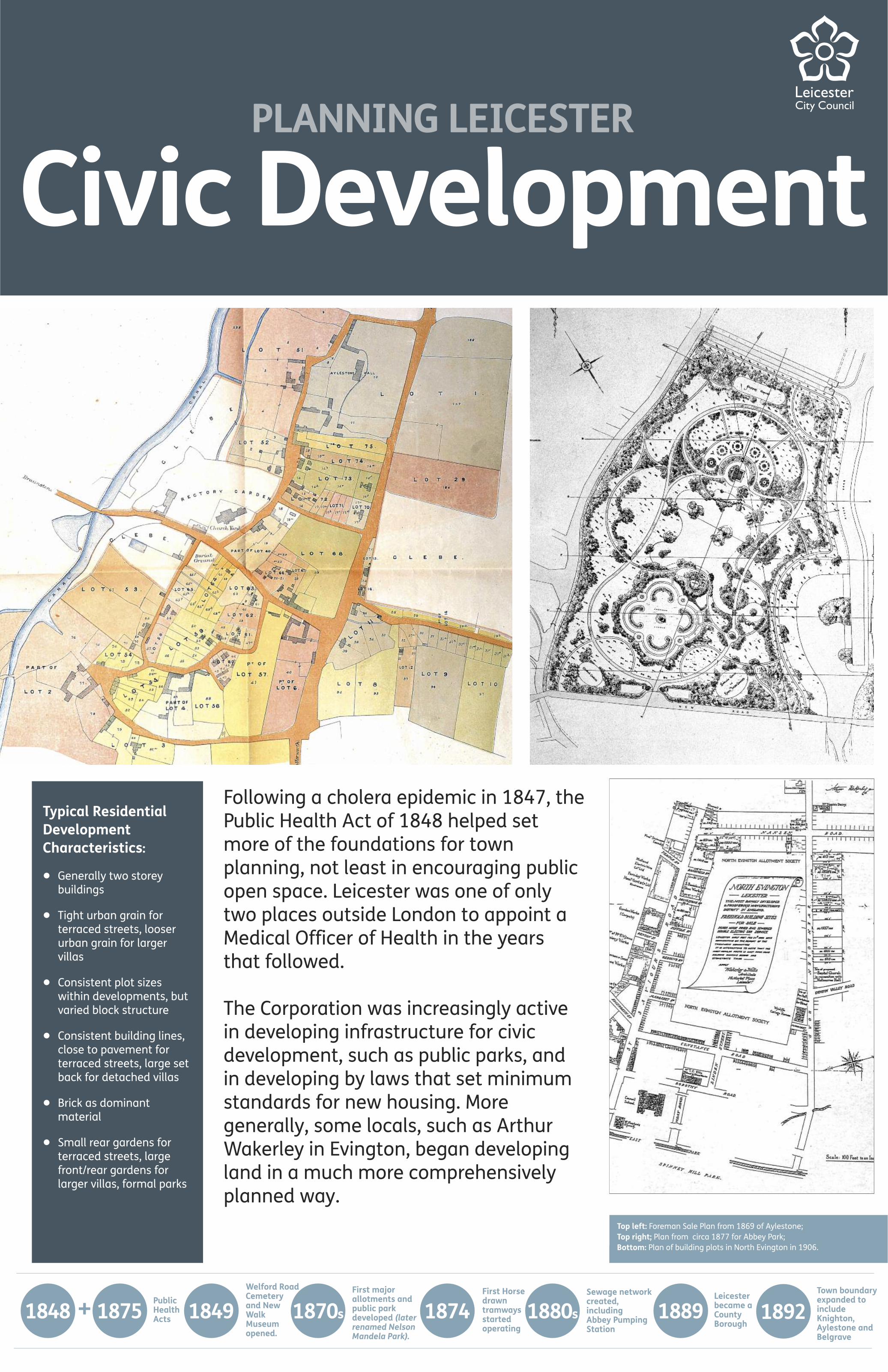
Top left: Foreman Sale Plan from 1869 of Aylestone;Top right; Plan from circa 1877 for Abbey Park;Bottom: Plan of building plots in North Evington in 1906.
Following a cholera epidemic in 1847, thePublic Health Act of 1848 helped setmore of the foundations for townplanning, not least in encouraging publicopen space. Leicester was one of onlytwo places outside London to appoint aMedical Officer of Health in the yearsthat followed.
The Corporation was increasingly activein developing infrastructure for civicdevelopment, such as public parks, andin developing by laws that set minimumstandards for new housing. Moregenerally, some locals, such as ArthurWakerley in Evington, began developingland in a much more comprehensivelyplanned way.
PLANNING LEICESTER
Civic Development
Typical ResidentialDevelopmentCharacteristics:
l Generally two storeybuildings
l Tight urban grain forterraced streets, looserurban grain for largervillas
l Consistent plot sizeswithin developments, butvaried block structure
l Consistent building lines,close to pavement forterraced streets, large setback for detached villas
l Brick as dominantmaterial
l Small rear gardens forterraced streets, largefront/rear gardens forlarger villas, formal parks
Town boundaryexpanded toincludeKnighton,Aylestone andBelgrave
1892

TudorWaltersCommissionreport
1917Leicester gainscity status.Establishmentof Housing andTown PlanningCommittee by
1919ArthurWakerley –who wasfirst Chairman
Town &CountryPlanningAct
1932Town boundaryexpanded toinclude Evington,Humberstoneand Braunstone
1935
Top left: Sale plan of Western Park circa 1905Top right: Plan from 1923 of £299 houses;Middle: Plan from 1931 showing The Circle; Bottom: Plan from 1926 for the Braunstone Estate.
The early 20th century saw the firstdevelopment of town planninglegislation nationally and attempts atadopting a strategic plan for Leicesterlocally. Much development was stilluncoordinated as urbanisation continuedapace.
Influenced by the likes of EbenezerHoward and emerging pressure groups,such as the Garden Cities Association,various linked developments occurred inLeicester. A cooperative housing venturefrom Anchor Tenants Ltd developed landto the east of the old village ofHumberstone between 1907-1915, whilethe Corporation bought land inBraunstone to develop holistically from1927, supplementing housing with newshops, schools, churches and publictransport.
PLANNING LEICESTER
Typical ResidentialDevelopmentCharacteristics:
l Generally two storeybuildings
l Relatively tight urbangrain
l Variety of blocks designedaround series of greenspaces and ordered roadnetwork. Consistent,larger plot sizes
l Generally consistentbuilding lines behind frontgardens, althoughvariation in setbacksfollows a set pattern inplaces
l Brick, often coated withpaint/render, asdominant material
l Front/rear gardens, someintermediate landscapedspaces and formal parks,limited parking provision
Town PlanningEstablished
+1909Housing &TownPlanningActs
1919Frank Cottrillemployed byLeicester Council –one of the firstfield archaeologyposts in country
1938

BarlowReportpublished 1940
Town &CountryPlanningActs
Last tramservice incity 1949
FestivalofBritain 1951
Leicester CityDevelopmentPlan adopted 1952
City/CountyDevelopmentPlan 1956
Inner ringroadconstructionbegan
1958
Top left: Model from 1956 of proposed highways scheme on LondonRoad;Top right: Plan from 1952 showing proposed clearance of ‘slums’;Middle: Plan from 1949 for new bus station off Charles Street;Bottom: Plan from 1952 showing zoning of residential and industry.
Although World War II significantlycurtailed development activity in the city,the success of strategic planning duringthe conflict and a commitment todomestic renewal post-war hadsignificant impacts on planning inLeicester. A new national developmentcontrol regime that required developersto acquire planning permission for anextensive range of works was introduced.
There was a revival of the pre-war housebuilding programme by the Corporationwith the development of estates in areassuch as New Parks, Thurnby Lodge andStocking Farm. Slum clearanceprogrammes continued apace, whilstprivate development of housing in thesuburbs resumed.
PLANNING LEICESTER
Post-War Planning
Typical ResidentialDevelopmentCharacteristics:
l Generally two storeybuildings, with somebungalows and singlestorey prefabs
l Intermediate urban grain
l Variety of blocks designedaround series of greenspaces and ordered roadnetwork. Consistent,medium plot sizes
l Generally consistentbuilding lines behind frontgardens
l Brick, render and mock-Tudor style timbering asdominant material
l Front/rear gardens, someintermediate landscapedspaces and formal parks,modest parking provision
1943 1944 1947
Leicester & RutlandThe Buildings ofEngland (NikolausPevsner) published
1960The Death and Life ofGreat American Citiesand The conciseTownscape (Jane Jacobsand Gordon Cullen)published
1961City PlanningDepartmentestablished –2nd in country
1962Traffic inTowns report(ColinBuchanan)published
1963Leicester TrafficPlan published –1st in country 1964
PlanningAdvisoryGroupreport
1965
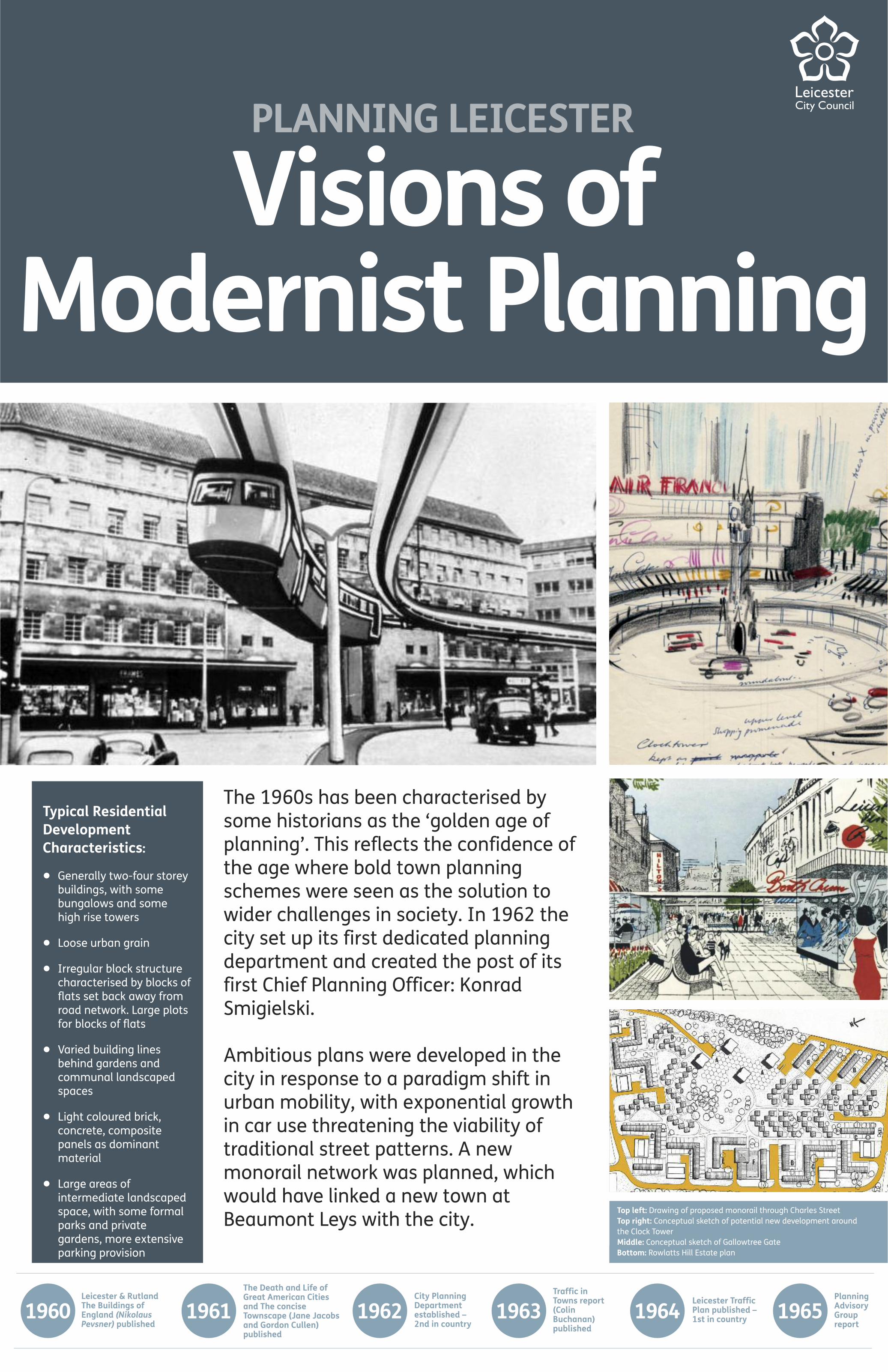
Top left: Drawing of proposed monorail through Charles StreetTop right: Conceptual sketch of potential new development aroundthe Clock TowerMiddle: Conceptual sketch of Gallowtree GateBottom: Rowlatts Hill Estate plan
The 1960s has been characterised bysome historians as the ‘golden age ofplanning’. This reflects the confidence ofthe age where bold town planningschemes were seen as the solution towider challenges in society. In 1962 thecity set up its first dedicated planningdepartment and created the post of itsfirst Chief Planning Officer: KonradSmigielski.
Ambitious plans were developed in thecity in response to a paradigm shift inurban mobility, with exponential growthin car use threatening the viability oftraditional street patterns. A newmonorail network was planned, whichwould have linked a new town atBeaumont Leys with the city.
PLANNING LEICESTER
Typical ResidentialDevelopmentCharacteristics:
l Generally two-four storeybuildings, with somebungalows and somehigh rise towers
l Loose urban grain
l Irregular block structurecharacterised by blocks offlats set back away fromroad network. Large plotsfor blocks of flats
l Varied building linesbehind gardens andcommunal landscapedspaces
l Light coloured brick,concrete, compositepanels as dominantmaterial
l Large areas ofintermediate landscapedspace, with some formalparks and privategardens, more extensiveparking provision
Visions ofModernist Planning

Section of M1motorwaythroughLeicestercompleted
1968Town and CountryPlanning Act- establishment ofStructure Plans
1968Skeffington Report;Housing Act andLeicester/LeicestershireSub-Regional PlanningStudy published
1969Urban and regionalplanning; a systemsapproach (J. BrianMcLoughlin)published
1969
Top left: 1960s model of Beaumont Leys Town Centre;Top right: 1953 plan for Belgrave Gate; Middle Plan of proposed market area from 1963;Bottom: Model of ‘regenerated’ city centre.
PLANNING LEICESTER
Visions ofModernist Planning
Civic AmenitiesAct –establishmentof conservationareas
1967
Alongside dramatic changes to the highway network,extensive investment was planned in new housing,commercial development and further slum clearance. Many ofthe plans were never realised, but some were – including thecontroversial development of the ring road in the historicwestern side of the city centre and the slum clearance thatfacilitated the building of the St Matthew’s and St Mark’sEstates.
Alongside some of the more futuristic design styles, the periodalso saw the development of national legislation to betterprotect heritage. In 1969 the first three conservation areaswere designated in the city at New Walk, Castle Gardens andGreyfriars.

Top left: Model of proposed ‘woonerf/home-zone’ for WorthingtonStreet in 1984;Top right: Clarendon Park General Improvement Area documentcover from 1971;Middle: 3D mock-up of Co-op plans for new retail centre off the HighStreet in 1981;Bottom: Out-of-town retail plan from late 1970s /early 1980s.
As the city continued to expand in thisperiod some of the orthodoxies ofmodernist town planning were foundwanting and urban renewal wasincreasingly focussed on enhancingexisting assets, rather thancomprehensively replacing them.Following the passing of the Housing Actin 1969, the Leicester HousingCommittee created plans for variousGeneral Improvement Areas, such asupgrading the housing stock inClarendon Park.
Innovative new approaches to streetsincluded pedestrianisation schemes inthe city centre and home zones inHighfields. Some of this was related toenhancing the retail offer of the citycentre to combat the threat of peripheralretail development by the M1.
PLANNING LEICESTER
Sustainabledevelopments
Typical ResidentialDevelopmentCharacteristics:
l Generally two-threestorey buildings
l Tight urban grain
l Varied block structurereflecting varied landparcels of sites. Irregularstructure of cul-de-sacstreets. Fairly consistentplot sizes
l Fairly consistent buildinglines behind frontgardens
l Brick/stone as dominantmaterials
l Front/rear gardens,limited intermediatelandscaped spaces,smaller formal parks,more parking
Local Government Act –major overhaul of waylocal government isorganised; John Deanbecame Head of Planningin Leicester
1972LeicesterCouncilreplacesLeicesterCorporation
1974Firstpedestrianisation of citycentre streets(GallowtreeGate)
1975LeicestershireStructure Planadopted 1976
Inner Urban AreasAct – shift in focustowards urbanregeneration
1978 –1978Eight LocalPlans adoptedfor differentparts of city
1988

Leicester wasdesignatedBritain’s firstEnvironmentCity
1990ShiresShoppingCentreopened
1991City ofLeicesterLocal Planadopted 1994 Western Bypass
completed 1995Leicester CityCouncilbecomesunitaryauthority
1997
Top left: Europa Nostra Award in 1989;Top right: Paving the Way content (1990);Middle: Site plan for Highcross Shopping Centre; Bottom: Riverside Park exhibition.
City ofLeicesterLocal Planadopted
2006HighcrossShopping Centreand CurveTheatre opened
2008
In this period, Leicester came to the forefront for developingprotection and proactive enhancement plans for the naturalenvironment. One of the first Council’s to employ a full timeecologist, ground-breaking work in managing flood risk,allocating land for community buildings and inclusive designalso took place.
In 1989 the multi-award winning Leicester Ecology Strategywas published. One aspect of this was the creation of theRiverside Park, which won the prestigious Europa NostraAward in 1989. Much of this work helped contribute to thecity being designated Britain’s first Environment City in 1990.
Leicester set the standard for embedding inclusive designinto the planning system in the 1980s. The Council were thefirst in the UK to employ a Disabled People’s Access officer in1981 and one of the first to establish a Disabled People’sAccess Group.
PLANNING LEICESTER
Sustainabledevelopments
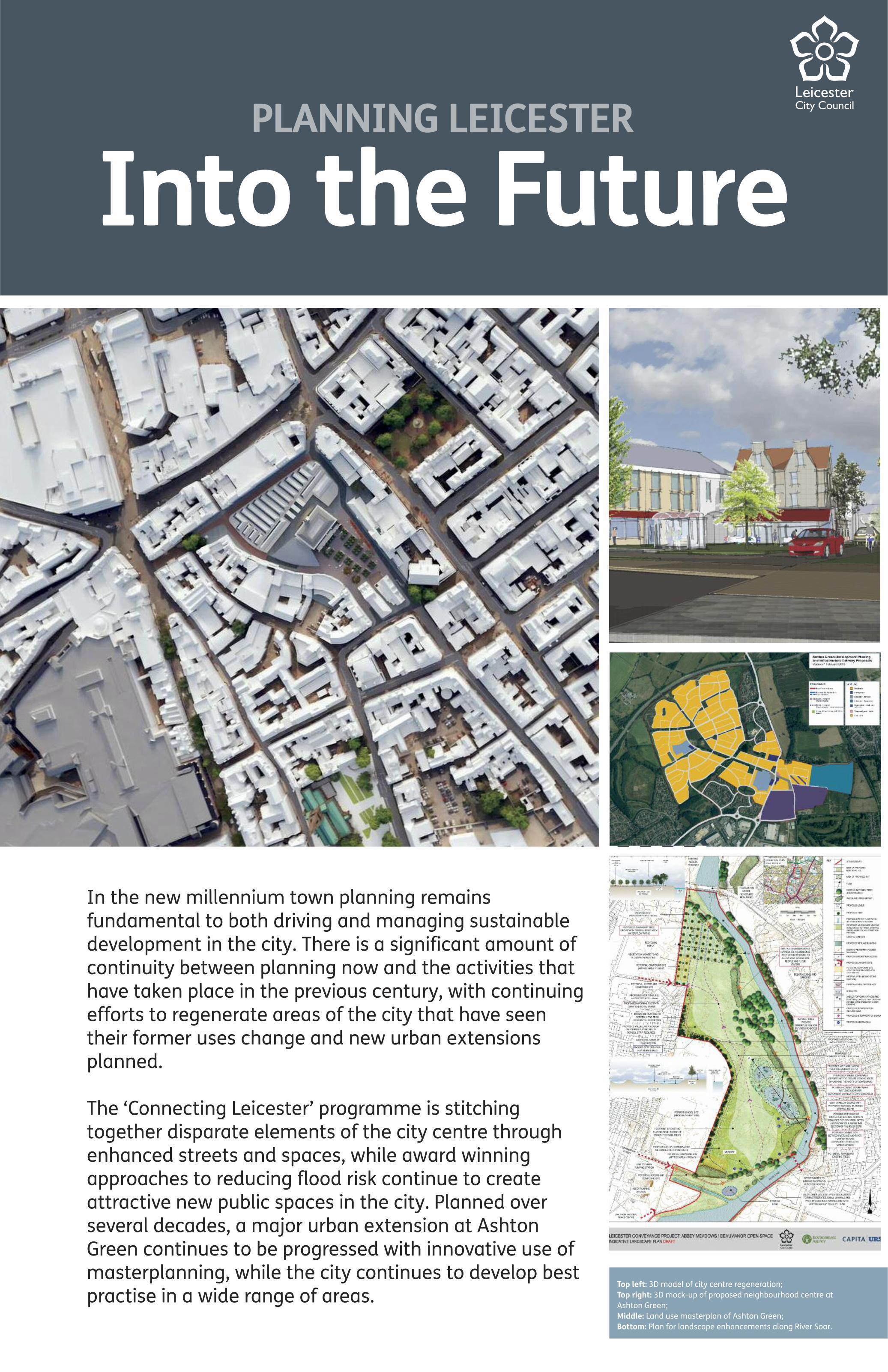
Top left: 3D model of city centre regeneration;Top right: 3D mock-up of proposed neighbourhood centre atAshton Green;Middle: Land use masterplan of Ashton Green;Bottom: Plan for landscape enhancements along River Soar.
PLANNING LEICESTER
Into the Future
In the new millennium town planning remainsfundamental to both driving and managing sustainabledevelopment in the city. There is a significant amount ofcontinuity between planning now and the activities thathave taken place in the previous century, with continuingefforts to regenerate areas of the city that have seentheir former uses change and new urban extensionsplanned.
The ‘Connecting Leicester’ programme is stitchingtogether disparate elements of the city centre throughenhanced streets and spaces, while award winningapproaches to reducing flood risk continue to createattractive new public spaces in the city. Planned overseveral decades, a major urban extension at AshtonGreen continues to be progressed with innovative use ofmasterplanning, while the city continues to develop bestpractise in a wide range of areas.
3D mock-up of proposedneighbourhood centre at