planning report for 50 alma -moonlight road, alma
TRANSCRIPT
PLANNING REPORT FOR 50 ALMA -MOONLIGHT ROAD, ALMA

Page 2 of 60
2077 50 Alma-Moonlight Road, Alma Feb 2021
Planning Report for 50 Alma-Moonlight Road, Alma.
Project: A dwelling and subdivision in Farming Zone
Report prepared by: Julie Lee of NR Links Town Planning , Town Planner (PIA Assoc), Post grad.Dip
Planning, Post grad Dip Bushfire Planning, Management. Dip Conservation and Land Management
and Cert.Horticulture
Natural Resource Link
ABN 23 578 685 507
Po. Box 61, Clunes, Vic, 3370
Ph: 0406 459 522
Email: [email protected]
Copyright
Natural Resource Link shall retain ownership of the reports and drawings, design, displays and other
work produced by Natural Resource Link during the course of fulfilling a commission until final
payment by the client.
Disclaimer
Natural Resource Link does not accept any liability for an error, omission or loss or other
consequence that may arise from relying on this report.
REV DATE DETAILS
FINAL 24/6/2021
Page 3 of 60
2077 50 Alma-Moonlight Road, Alma Feb 2021
TABLE OF CONTENTS
Summary ........................................................................................................................................... 4
INTRODUCTION ................................................................................................................................. 5
Landscape Context. ....................................................................................................................... 6
Land Use........................................................................................................................................ 9
Object site ........................................................................................................................................ 11
Images ........................................................................................................................................ 12
Soil Type for Agricultural Use .......................................................................................................... 29
Australian soil class ..................................................................................................................... 29
Land System ............................................................................................................................... 30
Land Form ................................................................................................................................... 30
Ground water and Salinity ............................................................................................................ 33
Land Capability Assessment-Agricultural Class ............................................................................... 34
Summary .................................................................................................................................... 36
PROPOSAL ........................................................................................................................................ 37
Agricultural use: ........................................................................................................................... 37
Proposed Dwelling- Lot.1: ............................................................................................................ 38
Proposed Dwelling- Lot.1 ............................................................................................................. 38
State Planning Policy Framework ..................................................................................................... 39
LOCAL PLANNING POLICY FRAMEWORK ......................................................................................... 39
CONCLUSION ................................................................................................................................... 52
Dwelling response ....................................................................................................................... 52
References ...................................................................................................................................... 54
Appendix.1 Title .............................................................................................................................. 55
Appendix.2 Existing Plan .................................................................................................................. 56
Appendix.3-Proposed plan ............................................................................................................... 57
Appendix.4. House Plan .................................................................................................................. 58
Appendix.5 Conservation/Farm Plan .............................................................................................. 59
Appendix.6 Introduction to Sodic soils ............................................................................................ 60

Page 4 of 60
2077 50 Alma-Moonlight Road, Alma Feb 2021
SUMMARY
The following is covered in detail in this application:
• Application is for a dwelling to enable the landowner a base from which to undertake
conservation works
• Site has risk of salinity
• Site demonstrates historic clearing that can lead to land degradation
• Waterway on site and road reserve shows no signs of erosion
• A Section 173 agreement to protect areas of high biodiversity and threatened species from
further fragmentation. The area is to be nominated on title and a Conservation Plan to be
annexed onto the title to educate and inform current and future owner of conservation
responsibilities on site.
• Pest plants noted on site
• Salt indicator plants noted on site
• Current owner very conscientious and excited about conservation on site.
• Site has no potential to create any land use conflicts due to vegetation
• Soil is Class 4-5 low-no agricultural ability
• Site will need to demonstrate capacity for a dwelling in relation to salinity

Page 5 of 60
2077 50 Alma-Moonlight Road, Alma Feb 2021
INTRODUCTION
Applicant NR Links Town Planning
Proposal A dwelling and subdivision
Location 50 Alma-Moonlight Road, Alma
Zone Farming Zone (FZ)
Schedule to Farming Zone
Erosion Management Overly (EMO)
Land Subject to inundation (LSIO)
Lot size 52.79124ha
Responsible Authority Central Goldfields
Prepared by NR Links Town Planning

Page 6 of 60
2077 50 Alma-Moonlight Road, Alma Feb 2021
Natural Resource Link has been engaged by the owner to submit a Planning Permit Application on
their behalf for a subdivision and development. The owner has had difficulties with farming the land
mainly due to its capacity and are looking for a change. However, they would like to remain in the
area and build a dwelling on site and to sell the bulk of the lot for farming. The lot for farming Lot 2
is over the trigger for a dwelling but land risks (salinity) are an issue that would not be dealt with for
a dwelling so it is recommended in this report that it be included in this application if the site has the
capacity. This will ensure a good planning outcome and avoid any issues on Lot 2 that is over size and
really has a right of use for a dwelling.
Landscape Context.
The landscape is mostly open rural land with a mix of cropping/grazing, remnant vegetation and
hobby farms. The landscape is flat and is serviced by sealed and all-weather roads and has a mixture
of developed and undeveloped lots.
The open landscape has a major watercourse ( Timor Creek) and many tributaries; with several small
reserves. The Maryborough-St Arnaud is the main highway that passes the site to the north-east and
current access to site is from the Alma-Moonlight road (unsealed).

Page 7 of 60
2077 50 Alma-Moonlight Road, Alma Feb 2021
Alma-
Moonlight
road
Page 8 of 60
2077 50 Alma-Moonlight Road, Alma Feb 2021
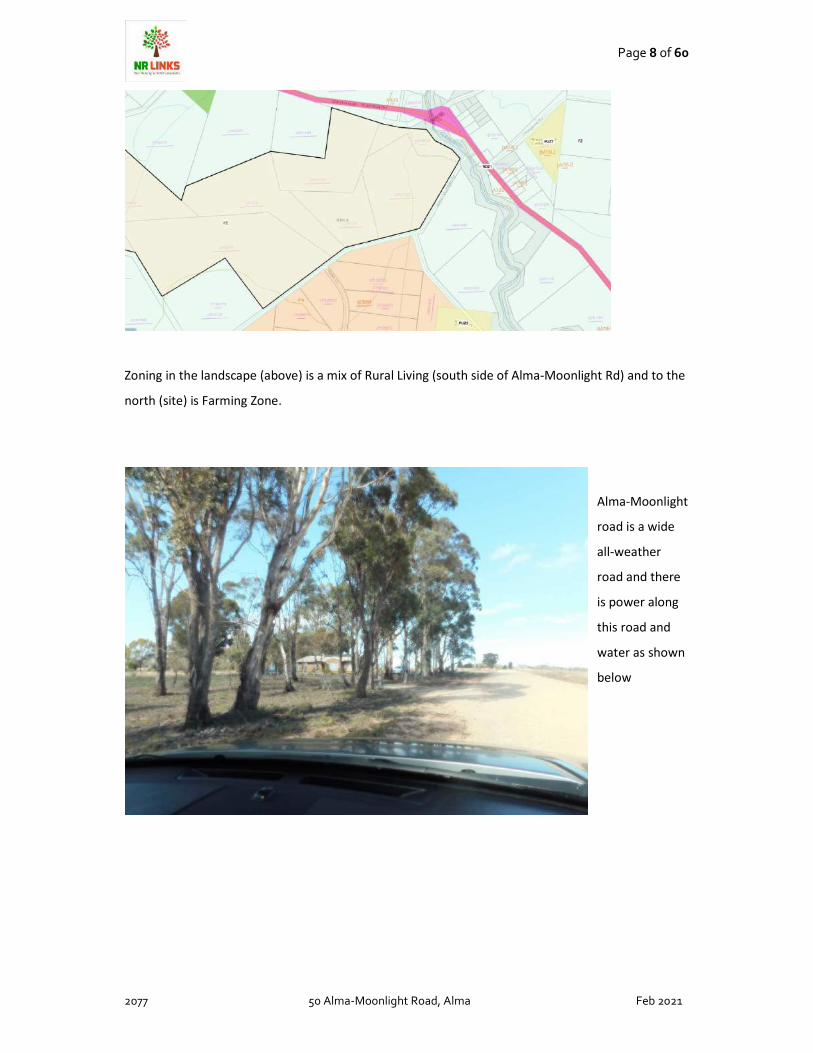
Zoning in the landscape (above) is a mix of Rural Living (south side of Alma-Moonlight Rd) and to the
north (site) is Farming Zone.
Alma-Moonlight
road is a wide
all-weather
road and there
is power along
this road and
water as shown
below

Page 9 of 60
2077 50 Alma-Moonlight Road, Alma Feb 2021
LAND USE

Page 10 of 60
2077 50 Alma-Moonlight Road, Alma Feb 2021
VLIUS (Victorian Land Use Information- above) states that the site is primarily shown to be
classified as
3.2 Grazing modified pastures (yellow above)
Pasture and forage production, both annual and perennial, based on significant active
modification or replacement of the initial vegetation. For ALUM purposes, this class is
used when there is greater than 50 per cent dominant exotic species while 2.1, ‘Grazing
native vegetation’, is applied when there is greater than 50 per cent dominant native
species.
Most jurisdictions have datasets specifically designed to distinguish native from non native
vegetation. These datasets should be used to report on native versus non-native
vegetation, as the ALUM Classification maps the actual land use as a priority over land
cover.
Land under pasture at the time of mapping may be in a rotation system, so that at
another time the same area may be, for example, under cropping. Land in a rotation
system should be classified according to the prime use (if known) or the land use at the
time of mapping, with rotation information recorded in the management field
The remainder of land (Zoned Rural Living) is mapped as:
5.4 Residential and farm infrastructure
Land with houses and or other residential infrastructure with or without associated
agricultural activity. This class includes urban and remote communities, farm buildings
and other farm infrastructure larger than the minimum mapping scale, and land in
transition to residential from other land uses. This class also includes holiday shacks.
5.4.2 Rural residential with agriculture—rural allotments with houses built (or
being built) and agricultural activity at the sub-commercial and/or hobby scale
(excluding backyard/domestic garden areas or livestock as pets). Rural
residential generally refers to areas with blocks larger than 0.2ha that are
located in a rural setting (away from the main urban setting), with agriculture
unlikely to be the main form of income. If agricultural activities are larger
than 2ha, they should be mapped separately under the relevant crop or
pasture class. When no agricultural activity is present allocate to class 5.4.3,
‘Rural residential without agriculture’.

Page 11 of 60
2077 50 Alma-Moonlight Road, Alma Feb 2021
Summary: The landscape is a used for grazing to the north of Alma-Moonlight Road and to the south
is residential low-density properties typical of the zoning (Rural Living)
OBJECT SITE
The subject site as shown below maps shows the remnant vegetation on site is mostly intact
remnant of very good quality mapped as 0.61-0.8 and consists of two EVC that are both endangered
in the Goldfields Bioregion.
Endangered is classified as
“Endangered
Status code: E
Contracted to less than 10% of former range; OR
Less than 10% pre-European extent remains; OR
Combination of depletion, degradation, current threats and rarity is comparable overall to the
above:
10 to 30% pre-European extent remains and severely degraded over a majority of this area; or
naturally restricted EVC reduced to 30% or less of former range and moderately degraded over a
majority of this area; or rare EVC cleared and/or moderately degraded over a majority of former
area.”
Biodiversity forms part of Farming Zone and is important for habitat and as climate change increases
in impacts will have impact on woodland communities.
“To encourage use and development of land based on comprehensive and sustainable land
management practices and infrastructure provision.”-Clause 35.07
Conservation of biodiversity and endangered flora forms part of state and local planning policy as
well.

Page 12 of 60
2077 50 Alma-Moonlight Road, Alma Feb 2021
IMAGES
Open pastures on
Lot.2 that show
cropping land use
from Alma-
Moonlight road
looking north
Adjacent dwelling
at 91 Alma-
Moonlight Rd,
Alma
Page 13 of 60
2077 50 Alma-Moonlight Road, Alma Feb 2021
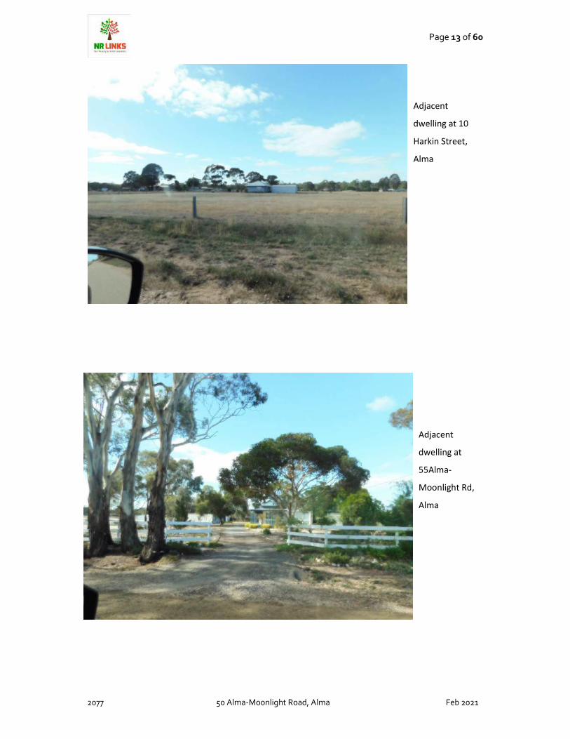
Adjacent
dwelling at 10
Harkin Street,
Alma
Adjacent
dwelling at
55Alma-
Moonlight Rd,
Alma
Page 14 of 60
2077 50 Alma-Moonlight Road, Alma Feb 2021
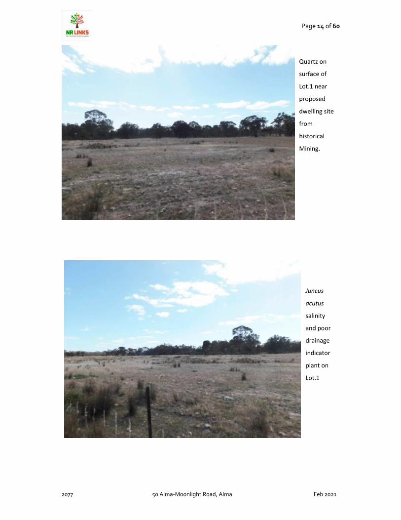
Quartz on
surface of
Lot.1 near
proposed
dwelling site
from
historical
Mining.
Juncus
acutus
salinity
and poor
drainage
indicator
plant on
Lot.1
Page 15 of 60
2077 50 Alma-Moonlight Road, Alma Feb 2021
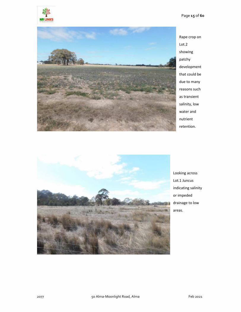
Rape crop on
Lot.2
showing
patchy
development
that could be
due to many
reasons such
as transient
salinity, low
water and
nutrient
retention.
Looking across
Lot.1 Juncus
indicating salinity
or impeded
drainage to low
areas.

Page 16 of 60
2077 50 Alma-Moonlight Road, Alma Feb 2021
Phalaris along
roadways (low
drainage
lines)and is also
a salt indicator
plant
Briar rose
(noxious weed
on L.ot.1

Page 17 of 60
2077 50 Alma-Moonlight Road, Alma Feb 2021
Quality
recruitment on
site of River
Red Gum
(Eucalyptus
camaldulensis)
Fenced of
area to the
north of
Lot.1
showing
recruitment
and a mix
of native
and exotic
grass

Page 18 of 60
2077 50 Alma-Moonlight Road, Alma Feb 2021
Drainage
line on
Lot.1
Soil
showing
low
ground
cover and
amount of
rock on
the
surface

Page 19 of 60
2077 50 Alma-Moonlight Road, Alma Feb 2021
Cropped
paddock on
crown
allotment 8
(part of
proposed
Lot.2)
Beautiful old
large
scattered
Yellow Gum
(Eucalyptus
leucoxylon)
On Lot.1 with
Acacia
paradoxa
understorey.

Page 20 of 60
2077 50 Alma-Moonlight Road, Alma Feb 2021
Noxious
weed Box
Thorn on
Lot.1
Exotic trees on
Lot.1 with signs
of brick from a
former house
site. These
Elms are
recruiting from
roots all over
the area and
these would be
removed to
protect
biodiversity
Page 21 of 60
2077 50 Alma-Moonlight Road, Alma Feb 2021
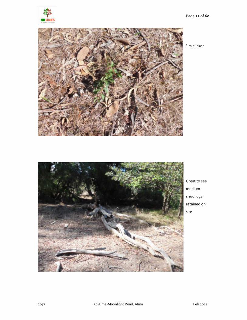
Elm sucker
Great to see
medium
sized logs
retained on
site

Page 22 of 60
2077 50 Alma-Moonlight Road, Alma Feb 2021
Roadside
vegetation
to the north
of Lot.1
Woolly Clover
s a low
salinity and
bad drainage
indicator plan

Page 23 of 60
2077 50 Alma-Moonlight Road, Alma Feb 2021
Spear Grass
(remnant)
Austrostipa
sp. and have
low
tolerance of
salinity.
Salt Grass
(Distichlis
distichophylla) a
higher-level salt
indicator plant
found in lower
areas

Page 24 of 60
2077 50 Alma-Moonlight Road, Alma Feb 2021
Horehound
(Marrubium
vulgare) which is
a salt
indicator/low
nutrient.
Drainage line
show peds
(clay-
indicating
impeded
drainage) and
salt grass
Page 25 of 60
2077 50 Alma-Moonlight Road, Alma Feb 2021
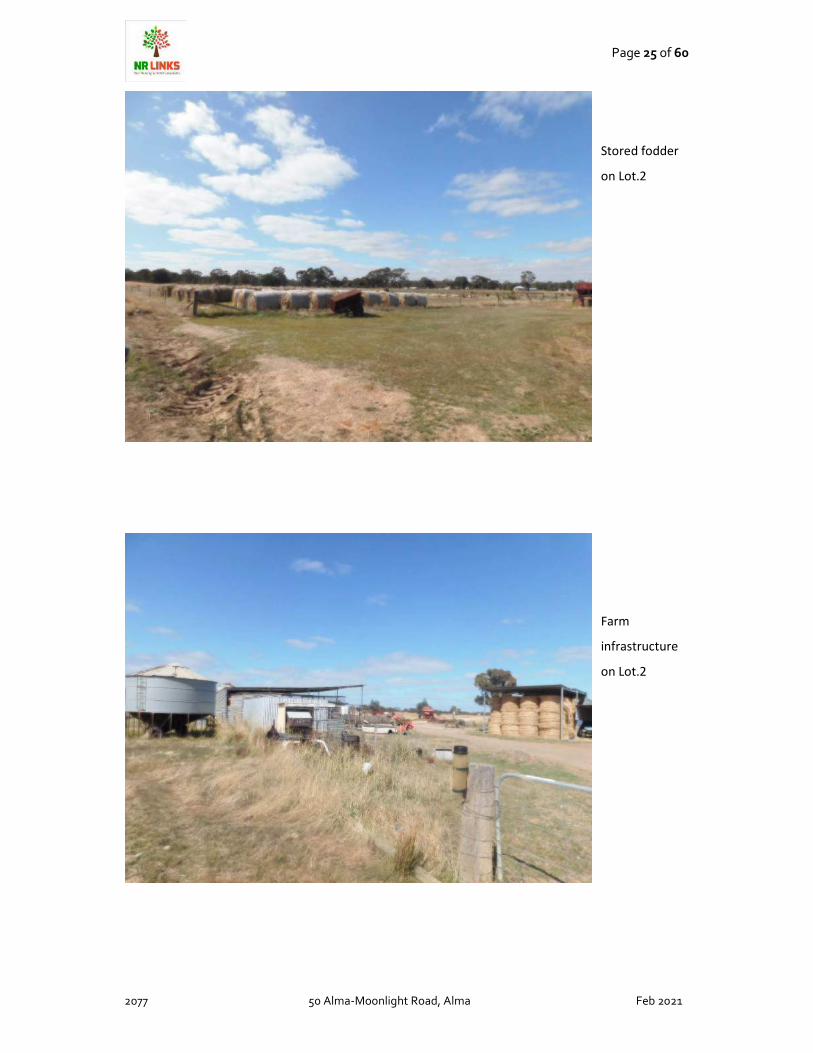
Stored fodder
on Lot.2
Farm
infrastructure
on Lot.2

Page 26 of 60
2077 50 Alma-Moonlight Road, Alma Feb 2021
Dam on Lot.2
Bathurst Burr
(weed) on Lot.2
due to soil
disturbance near
dam.

Page 27 of 60
2077 50 Alma-Moonlight Road, Alma Feb 2021
North end of Lot.1
near Mullock heap
showing high
density of
Austrostipa sp.
Mullock heap on
site
Lot.2

Page 28 of 60
2077 50 Alma-Moonlight Road, Alma Feb 2021
Far north
extremity of
Lot.2 along
Walkers Road.

Page 29 of 60
2077 50 Alma-Moonlight Road, Alma Feb 2021
SOIL TYPE FOR AGRICULTURAL USE
AUSTRALIAN SOIL CLASS
The Australian soil class for this site is a Sodosol that cover 30% of Australia
(A) Mottled Brown Sodosol
These soils have yellow to brownish yellow coloured upper subsoil horizons that are usually mottled.
The subsoils are usually coarsely structured, and prismatic and/or columnar peds are common. They
are generally specific to mid-range rainfall areas (i.e. 500-800 mm) and commonly occur in the
Uplands regions as well as in the western volcanic plains and southern plains of Victoria. These soils
mainly support dryland sheep grazing and are common in a number of areas of Victoria where gold-
mining has taken place (e.g. central goldfields region). Further information is provided on this soil,
including a case for why it should be considered as the State Soil for Victoria
Soil profile image of soil on site (left)
Managing sodic soils is included in
Appendix…..

Page 30 of 60
2077 50 Alma-Moonlight Road, Alma Feb 2021
LAND SYSTEM
The site is mapped to be 2.1PfQ5-7 which is a duplex soil with the following susceptibilities to land
degradation:
• Compaction High
• Leaching Moderate
• Mass Movement Nil
• Salinisation Moderate
• Water Erosion Nil
• Water logging Nil
• Wind Erosion Nil
LAND FORM
2.1.7 Terraces and floodplains (Upper Loddon, Upper Woady Yallock Creek, Pomonal -
Moyston area, Crowlands, Avoca, Newstead)
2. Western Uplands (WU)
2.1 Dissected Uplands
Alluvial flats are a common feature in most valley floors.
In some valleys, the majority of the alluvium has been
deposited in episodes of drainage disruption and
blockages during the Late Neogene volcanism. Examples
include the extensive alluvial flats of the Lal Lal Swamp
and Dog Trap Creek. Some minor sandy deposits are
associated with the Lal Lal swamp (lunette).
Soil types present include dark self-mulching clays,
texture contrast soils, some gradational soils and minor
sandy soils.
Alluvial systems within the Dissected Uplands of the
Wimmera CMA region include Mount Cole Creek,
Mount William Creek and the Wimmera River. Mount
Cole Creek, the upper Wimmera River and other minor
tributaries are supplied surface and groundwaters
by Palaeozoic bedrock hilly terrain and Neogene
cappings that line many lower hillslopes. As a tributary

Page 31 of 60
2077 50 Alma-Moonlight Road, Alma Feb 2021
that supplies the Wimmera River, Mount William Creek
rises on the slopes of Mt. William in the Grampians and
flows slowly to the north-west through Dadswells
Bridge. Extensive alluvial plains of this drainage system
represent a low pass (geocol) that separates the
Dissected Uplands (Midlands) to the east from the
Grampians to the west.
These fluviatile alluvia plains are characterised by its effluents and anabranches which leave the
main channels (Sibley 1967). The tributaries are called subsequent streams where streams have
evolved along areas of rock belt weakness leaving folded or titled strata of differing resistance as
prominent strike ridges (Hills 1975). Drainage networks of Mount William Creek, Salt Creek, upper
Wimmera River/Mount Cole Creek and Wattle Creek are aligned in a north north-westerly alignment
with strike ridges on a regular spacing of 10-15 kilometres. Valley flats, terraces and flood out plains
are common with Mount William Creek broadest in cross tributary dimension (often in excess of 5
kilometres) while others are typically less than 2 kilometres. Slopes are gentle to very gently inclined
with terrace slopes of greatest inclination (up to 10%) found along Mount Cole Creek and upper
Wimmera River.
The entrenched valleys of Quaternary sediments including the Shepparton Formation (a thick
sequence of unconsolidated fluvial and lacustrine sediments – coarse sand, silt and clay) occur
largely as terraces, plains and drainage lines. Sediments have been derived through differential
weathering of granite masses that are surrounded by ridges and peaks of
resistant metamorphosed sediments. The Coonambidgal Formation (reworked Shepparton
Formation of slightly micaceous silty clay, sand and gravel) occur within drainage lines subject to
flooding and inset streams (Butler 1958, Krokowski de Vickerod, Moore & Cayle 1997).
Flood plains of Mount William Creek are lined by aeolian deposits (sands) sourced from the
Grampians and lined by River Red gums on subdued slopes of this inset stream. The plains and
terraces of the upper reaches of the Wimmera River system around Mount Cole Creek, Concongella
and Elmhurst have been formed by the more rapid weathering of granitic rocks in the area,
accompanied by the deposition of recent alluvial sediments. Incipient weathering profiles of older
fluvial deposits have some mottling reflecting poor site drainage and clay alleviation processes.
Granitic detritus of these valley systems has high concentrations of quartzose sand intermixed with
silts that often compose terraces occupying elevated positions above the current drainage plain.
Soils of the unit are deep grading into the generally unconsolidated regolith. These may range from
Page 32 of 60
2077 50 Alma-Moonlight Road, Alma Feb 2021
texture contrast, generally sodic (Sodosols) to gradational earths and occasional clay
(Vertosols, Dermosols) and sandy soils (Tenosols). Some soils may be waterlogged prone for at least
3 months of the year (Hydrosols).
The texture contrast soils vary between the red non-sodic soils against the brown, yellow and grey
sodic variants. All have sandy loam surfaces overlying a massive conspicuously bleached subsurface
horizon. A clear change exists to light and medium clay subsoils where sodicity and colour are the
distinguishing features. Importantly, the red texture contrast soils are commonly associated with
terraces rather than current alluvial plains. Here most of the gradational yellow and brown soils
(Kandosols) are found.
Remnant vegetation communities are dominated by forests (Heathy Dry Forest and Grassy Forest)
closest to intersection of the Wimmera River downstream of Greens Creek where stream gradients
are low and anabranching is well defined. Woodlands including Damp Sands Herb-rich Woodland,
Plains Grassy Woodland, Creekline Grassy Woodland, Riparian Woodland, Plains Woodland, Grassy
Woodland occur along Mount William Creek with Lateritic Woodland, Sand Heathland, Sand Forest,
Red Gum Wetland and Sedge Wetland found on floodplains and flats away from the current
drainage depression.
Heathy Dry Forest and Grassy Forest vegetation communities are associated with exposed areas of
the alluvial plains of the Upper Wimmera River and Mount Cole Creek while Herb-rich Foothill Forest
and Valley Grassy Forest are more associated with sheltered areas higher in the catchment. Various
woodlands including Alluvial Terraces Herb-rich Woodland also occur across these valleys. Dry
woodlands dominate drainage of Six Mile Creek/Seven Mile Creek and Salt Creek.
The alluvial plains often compose later derived sediments that overlie gravels and sands of these
valley deposits. Large volumes of groundwater are attributed to these alluvial systems through
contributions of Grampians colluvium where rainfall is often twice that of the plains. Wetlands line
Mount William Creek especially north of Jallukar to its integration with the Wimmera River. Lake
Lonsdale and Lake Fyans represent large swamps that have now been dammed to form water supply
dams for Stawell and Ararat.
Further east, Greens Swamp (includes a main swamp and shallow ephemeral wetland) has been
derived from a small catchment that has been unable to breach the levee of the Wimmera River
(Hocking 2004). This swamp has a large clay lunette that predates major lake forming processes of
the Murray Basin and reflects an intricate balance between climatic and groundwater conditions for
lunette development.
Geology

Page 33 of 60
2077 50 Alma-Moonlight Road, Alma Feb 2021
The site is mapped to be the Shepparton Formation little is available for this soil in the North Central
Catchment Area A small areas to the South-east of Lot.2 is mapped to be the Castlemaine
Formation.
GROUND WATER AND SALINITY
Ground water on site is mapped
to be under 5m in depth.
Ground water salinity on site is
mapped to be high at 3500-
7000mg/l
Page 34 of 60
2077 50 Alma-Moonlight Road, Alma Feb 2021
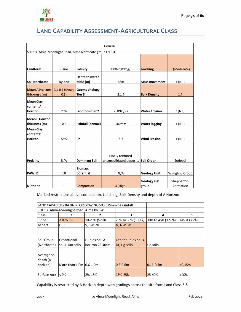
LAND CAPABILITY ASSESSMENT-AGRICULTURAL CLASS
Marked restrictions above compaction, Leaching, Bulk Density and depth of A Horizon
Capability is restricted by A Horizon depth with gradings across the site from Land Class 3-5
LAND CAPABILITY RATING FOR GRAZING 500-625mm pa rainfall
SITE: 50 Alma-Moonlight Road, Alma Dy 3.41
Class 1 2 3 4 5
Slope < 10% (5̊) 10-20% (5̊-10̊) 20% to 30% (10-17̊) 30% to 45% (17̊-24̊) >45 % (> 24̊)
Aspect E, SE S, SW, NE N, NW, W
Soil Group
(Northcote)
Gradational
soils, Um soils
Duplex soil A
horizon 25-40cm
Other duplex soils,
Ur, Ug soils Uc soils
Average soil
depth (A
horizon) More than 1.0m 0.6-1.0m 0.3-0.6m 0.15-0.3m <0.15m
Surface rock < 2% 2%-15% 15%-25% 25-40% >40%
Landform Plains Salinity 3000-7000mg/L Leaching 3 (Moderate)
Soil Northcote Dy 3.41
Depth to water
table (m) <5m Mass movement 1 (Nil)
Mean A Horizon
thickness (m)
0.1-0.6 (Mean
0.3)
Geomophology
Tier 3 2.1.7 Bulk Density 1.7
Mean Clay
content A
Horizon 20% Landform tier 2 2.1PfQ5-7 Water Erosion 1(Nil)
Mean B Horizon
thickness (m) 0.6 Rainfall (annual) 500mm Water logging 1 (Nil)
Mean Clay
content B
Horizon 55% Ph 5.7 Wind Erosion 1 (Nil)
Pedality N/A Dominant Soil
Finely textured
unconsolidated deposits Soil Order Sodosol
PAWHC 58
Biomass
potential N/A Geology Unit Wunghnu Group
Nutrient 1 Compaction 4 (High)
Geology sub
group
Shepparton
Formation
General
SITE: 50 Alma-Moonlight Road, Alma Northcote group Dy 3.41

Page 35 of 60
2077 50 Alma-Moonlight Road, Alma Feb 2021
Land Capability for Grazing limited to due to flooding and drainage on Lot.1 to a Land Class 4-5
Land Capability for Grazing limited to due to flooding and drainage on Lot.1 to a Land Class 3-5
LAND CAPABILITY RATING FOR INTENSIVE CROPPING
SITE: 50 Alma-Moonlight Rd Alma-Lot.1
FEATURES 1 2 3 4 5
Soil structure Weak 0-4% 4%-8% 8%-15% 15%-20% >20%
Gradient Moderate 0-8% 8%-15% 15%-20% 20%-35% >25%
Strong 0-15% 15% to 20% 20%-35% 35%-50% >50%
Flooding > 20yrs 20-10yrs 10-5 yrs 5ys-1yr >1yr
Soil drainage
class
Well-Mod
drainage
Excessively
well-drained
Imperfectly
drained
Poorly
drained
Very-poorly
drained
Rooting depth >50cm 30-50cm 20-30cm 15-20 cm <15cm
Texture of A
Horizon L,SL, CL SCL, LS,S C
Aggregate
Stability of A
Horizon 1 (stable) 2 3
4-5
(dispersive)
Gravels and
stones < 4% 4%-10% 10%-20% 20%-30% >30%
Boulders and
rocks outcrops <0.01% 0.01-0.05% 0.05-1% 1%-10% >10%
LAND CAPABILITY RATING FOR INTENSIVE CROPPING
SITE: 50 Alma-Moonlight Rd Alma-Lot.2
FEATURES 1 2 3 4 5
Soil structure Weak 0-4% 4%-8% 8%-15% 15%-20% >20%
Gradient Moderate 0-8% 8%-15% 15%-20% 20%-35% >25%
Strong 0-15% 15% to 20% 20%-35% 35%-50% >50%
Flooding > 20yrs 20-10yrs 10-5 yrs 5ys-1yr >1yr
Soil drainage
class
Well-Mod
drainage
Excessively
well-drained
Imperfectly
drained
Poorly
drained
Very-poorly
drained
Rooting depth >50cm 30-50cm 20-30cm 15-20 cm <15cm
Texture of A
Horizon L,SL, CL SCL, LS,S C
Aggregate
Stability of A
Horizon 1 (stable) 2 3
4-5
(dispersive)
Gravels and
stones < 4% 4%-10% 10%-20% 20%-30% >30%
Boulders and
rocks outcrops <0.01% 0.01-0.05% 0.05-1% 1%-10% >10%

Page 36 of 60
2077 50 Alma-Moonlight Road, Alma Feb 2021
SUMMARY
Analysis demonstrates soils capacity on site is limited due to A Horizon depth across the site and on
Lot.1 by inundation and soil rock. Outside of this salinity has been shown to be an issue on site and
typically sodosol soils have problems with sodicity and can be dispersive although this was not
demonstrated to be a severe problem on site with soils showing a low level of dispersiveness.
Typically salinity requires careful management and as some paddocks are irrigated particular
attention must be made to the choice of crops and the use of mixed species with deeper rooted
perennial crops will assist in retain salt levels at current levels. It is recommended that the soils be
tested for soils and an agronomist assist with improving the soil structure and raising soil levels to
further mitigate salinity issues on site.
Lot.1 would be classed as Class 4
Class 4 is defined by Department of Agriculture in the Assessment of Agricultural Land Capability in
Melbourne’s Green Wedge and Peri-urban Areas Agriculture Victoria Research Final Technical
Report Updated October 2018
Class 4: Land that is not as inherently capable for intensive soil-based agriculture. Extensive
agriculture (including broadacre cropping with suitable land management practices) and non-soil
utilisation activities are often most appropriate, and more intensive grazing is possible in some
higher rainfall areas or where consistent water supplies are available. Due to mapping resolution,
some minor exclusion areas (i.e. Class 5) can be present where land attributes (e.g. slope) vary
locally. Land management limitations are high to very high for intensive use. There are also likely to
be some areas of land within this Class that may have higher capability (e.g. suitable terrain with
soils that have deep sandy surface horizons) but that are not able to be identified at this stage due to
the broad scale of soil/landscape mapping available across much of the study area. Class 4 land
covers 36% of the total land in the study area.
Lot.2 would be classified at present a higher level 3
Class 3: Land that is inherently capable for soil-based agriculture at moderate to high intensity. The
potential/capability may vary (e.g. according to slope, inherent fertility and drainage) but is often
realised with access to a constant water supply. Many landscapes with deeper sandy soils are
represented here – which are highly suited to horticulture once land-forming, drainage, fertilisers
and irrigation is provided. Suitable landscapes with more favourable texture-contrast soils (e.g.
deeper surface horizons, relatively friable and stable upper subsoils) are also included. Land
management limitations are slight to moderate for intensive use. Class 3 land covers around 9% of
Page 37 of 60
2077 50 Alma-Moonlight Road, Alma Feb 2021
the total land in the study area.
PROPOSAL
Planning approval is sought for a subdivision and development application on site.
Lot.1 will be 9.9ha under size for a subdivision under farming zone but consolidates two existing lots,
protects endangered biodiversity, agricultural capacity on site is very low and requires mitigation of
land degradation and an integrated land management on site to provide a sustainable response to
the farming zone This lot will be developed by the owners and the site is within an area of
development. Dwelling will require salinity testing to ensure that footings will not be compromised.
Lot.2 will be 42.77ha remain a farming lot and will be sold off to allow for continued farming activity
albeit it will be required salinity testing and careful management of any continued irrigation on site.
It will be in consultation with council as to whether a development application is best dealt with at
this stage that provides control over the placing of housing (mitigates land use conflicts) and ensures
the site is tested for salinity levels (house footings) and can be additionally located in an area of
lower agricultural quality, this achieving a more desirable response to the farming zone objectives.
AGRICULTURAL USE:
It has been clearly demonstrated in this report that the soils, ground water, biodiversity salinity play
an important factor in the ongoing sustainability of this site to mitigate affects of climate change and
to ensure potential land degradation can be mitigated.

Page 38 of 60
2077 50 Alma-Moonlight Road, Alma Feb 2021
Proposed Dwelling- Lot.1:
Approval is sought for a three-bedroom residence on site to enable the land manager to
reside on Lot.1 . Many studies have shown that land that has little or no use for agriculture; or is left
developed is most likely to further degrade. It is also recommended that this dwelling be tied to the
use of the land for reversing land management. The remnant vegetation is of high value and
classified as endangered, so ongoing appropriate management is essential to ensure that the quality
is retained and not lost over time. The site has the capacity to connect to potable water and
electricity if required.
PROPOSED DWELLING- LOT.1

Page 39 of 60
2077 50 Alma-Moonlight Road, Alma Feb 2021
STATE PLANNING POLICY FRAMEWORK
LOCAL PLANNING POLICY FRAMEWORK
Clause 11.01-1L Settlement - Central
Goldfields Strategies Provide medium
density residential opportunities close to
Maryborough Central Business Area.
Provide low density and rural living
opportunities around the periphery of
Maryborough and other centres where they
do not conflict with environmental and
agricultural objectives and where
infrastructure can be supplied in a cost-
effective way.
The site is in close proximity to Maryborough and
conflict with bushfire, environmental and
agricultural objectives can be managed and
mitigated
The site has good access to infrastructure such as
access, power and potable water.
Clause 12.01-1S Protection of biodiversity
Objective To assist the protection and
conservation of Victoria’s biodiversity.
Strategies Use biodiversity information to
identify important areas of biodiversity,
including key habitat for rare or threatened
species and communities, and strategically
valuable biodiversity sites. Strategically
plan for the protection and conservation of
Victoria’s important areas of biodiversity.
Ensure that decision making takes into
account the impacts of land use and
development on Victoria’s biodiversity,
including consideration of: Cumulative
impacts. Fragmentation of habitat. The
spread of pest plants, animals and
pathogens into natural ecosystems
KEEP JUST CHECK WORDING
This application covers the high level of quality
vegetation on site and the site survey concurs with
the mapped condition scores. The EVC’s involved
are both Endangered in the Goldfields Bioregion
and require careful land management to ensure
long term sustainability. This can be achieved
through a planning application for a development
application only if an Integrated Land Management
is prepared and annexed to the title to inform not
only current but future land owners.
Application also looks at the fragility of fragmented
vegetation and the impact of salinity and weeds on
site.
Clause 12.01-2S Native vegetation
management Objective To ensure that
there is no net loss to biodiversity as a
result of the removal, destruction or
No vegetation removal is to be lost as part of this
application and this application ensures that the

Page 40 of 60
2077 50 Alma-Moonlight Road, Alma Feb 2021
lopping of native vegetation. Strategies
Ensure decisions that involve, or will lead
to, the removal, destruction or lopping of
native vegetation, apply the three-step
approach in accordance with the
Guidelines for the removal, destruction or
lopping of native vegetation (Department
of Environment, Land, Water and Planning,
2017): Avoid the removal, destruction or
lopping of native vegetation. Minimise
impacts from the removal, destruction or
lopping of native vegetation that cannot be
avoided. Provide an offset to compensate
for the biodiversity impact from the
removal, destruction or lopping of native
vegetation.
KEEP JUST CHECK WORDING
vegetation on site can be managed sustainability
for the future.
Clause 13.02-1S Bushfire planning Policy
application This policy must be applied to
all planning and decision making under the
Planning and Environment Act 1987
relating to land that is: Within a designated
bushfire prone area; Subject to a Bushfire
Management Overlay; or Proposed to be
used or developed in a way that may
create a bushfire hazard. Objective To
strengthen the resilience of settlements
and communities to bushfire through risk-
based planning that prioritises the
protection of human life.
KEEP JUST CHECK WORDING
The site is not within a high bushfire risk area and
is classed as Bushfire Prone.
Clause 14 NATURAL RESOURCE
MANAGEMENT Planning is to assist in the
conservation and wise use of natural
resources including energy, water, land,
stone and minerals to support both
environmental quality and sustainable
development. Planning should ensure
agricultural land is managed sustainably,
while acknowledging the economic
importance of agricultural production.
KEEP JUST CHECK WORDING
Natural resources on site are of high risk from
fragmentation, loss (firewood or inappropriate
clearing), weed infestation and salinity. Planning
should ensure that future land management on
site considers the risk to the land and that these
risks are mitigated.

Page 41 of 60
2077 50 Alma-Moonlight Road, Alma Feb 2021
Clause 14.01-1S Protection of agricultural
land Objective To protect the state’s
agricultural base by preserving productive
farmland.
KEEP JUST CHECK WORDING
Site soils Land Class is not just noted but
scientifically evaluated using CSIRO data to provide
a quantifiable Land Class level. This application for
a subdivision ensures that any development will
not result in a loss of productive agricultural land.
Clause 14.01-2S Sustainable agricultural
land use Objective To encourage
sustainable agricultural land use. Strategies
Ensure agricultural and productive rural
land use activities are managed to
maintain the long-term sustainable use and
management of existing natural resources.
Support the development of innovative
and sustainable approaches to agricultural
and associated rural land use practices.
KEEP JUST CHECK WORDING
A holistic response to all factors on site have been
assessed and photographic evidence supplied
along with data (outsourced) to review what the
capacity of the site is to ensure that the application
will provide options for sustainable land use for the
future .
Clause 14.01-2L Sustainable agricultural
land use - Central Goldfields Strategies
Encourage development of poultry
abattoirs and finished poultry product
processing in the Shire. Ensure intensive
agriculture is located to minimise risks
associated with effluent disposal and
protect the amenity of adjacent land uses.
This application does not involve any intensive
agriculture.
Clause 15.01-6S Design for rural areas
Objective To ensure development respects
valued areas of rural character. Strategies
Ensure that the siting, scale and
appearance of development protects and
enhances rural character. Protect the
visual amenity of valued rural landscapes
and character areas along township
approaches and sensitive tourist routes by
ensuring new development is
sympathetically located. Site and design
development to minimise visual impacts on
surrounding natural scenery and landscape
features including ridgelines, hill tops,
waterways, lakes and wetlands.
KEEP JUST CHECK WORDING
Application is homogenous to the landscape and
the siting and scale. Vista in the landscape is
already developed and these issues have been
heavily supported by VCAT in decision making.
Applying for a development application on both
sites is a preferred option as siting on Lot.2 will not
trigger a planning permit but can be controlled as
an outcome of this application. Application reduces
the likelihood of dwellings by reducing the current
lots to 2. Application ensures that low agricultural
land and biodiversity can be separated from the
balance of the land and managed sustainably. This
proposal also ensures that the risks to agriculture
on Lot 2 can be mitigated through testing the soils

Page 42 of 60
2077 50 Alma-Moonlight Road, Alma Feb 2021
for salinity and using sustainable agriculture to
ensure salinity is mitigated in the long term.
16.01-3S 09/10/2020 VC169 DO NOT PUT
THE DATE OF THE AMENDMENT AND
AMENDMENT NO IN ANY REPORTS PLEASE
DELETE.
Rural residential development Objective
To identify land suitable for rural residential
development. Strategies Manage
development in rural areas to protect
agriculture and avoid inappropriate rural
residential development. Encourage the
consolidation of new housing in existing
settlements where investment in physical
and community infrastructure and services
has already been made. Demonstrate need
and identify locations for rural residential
development through a housing and
settlement strategy. Ensure planning for
rural residential development avoids or
significantly reduces adverse economic,
social and environmental impacts by:
Maintaining the long-term sustainable use
and management of existing natural
resource attributes in activities including
agricultural production, water, mineral and
energy resources. Protecting existing
landscape values and environmental
qualities such as water quality, native
vegetation, biodiversity and habitat.
Minimising or avoiding property servicing
costs carried by local and state
governments. Maintaining an adequate
buffer distance between rural residential
development and animal production.
Ensure land is not zoned for rural residential
development if it will encroach on high
quality productive agricultural land or
adversely impact on waterways or other
natural resources. Discourage development
Application seeks to retain and manage in
perpetuity the remnant vegetation to an
appropriate level in perpetuity.
Retention of vegetation increases carbon
sequestration and achieves state and federal
biodiversity requirements.
Retention of remnant vegetation ensures long
term appropriate management is informed to land
holders to ensure long term sustainability.
Dwelling siting/capacity on site will need to be
demonstrated with soil testing for salinity levels.
No additional servicing requirements will be placed
on council as road is of adequate width and
maintained by council. Waste is currently collected
by council and will invoke 1-2 extra stops by the
contractor.
Current land use does not require any buffers
between land use and the landscape is moderately
developed so land use conflicts will be minimal
from development on site.
Development on site is homogeneous with the
surrounding land use.
Development on site can be supplied with
telecommunications, potable water and electricity
as well as good road access.

Page 43 of 60
2077 50 Alma-Moonlight Road, Alma Feb 2021
of small lots in rural zones for residential
use or other incompatible uses. Encourage
consolidation of existing isolated small lots
in rural zones. Ensure land is only zoned for
rural residential development where it: Is
located close to existing towns and urban
centres, but not in areas that will be
required for fully serviced urban
development. Can be supplied with
electricity, water and good quality road
access
Clause 21.04-1 Natural environment The
environmental policies for the Shire are: To
minimise the potential of new
development and land use causing
pollution of waterways, water storages and
ground water resources, land degradation,
fire hazards or other adverse
environmental impacts. To promote the
effective and responsible management of
flood plains and other low-lying areas
which are subject to drainage difficulties.
To give effect to policies and guidelines
which have been prepared by the
Environment Protection Authority for the
protection of the environment. To
encourage agriculture and other industries
to conserve water and minimise waste. To
support the catchment management
strategies of the North Central, Glenelg
and Wimmera Catchment and Land
Management Authorities. To protect
existing native vegetation and encourage
further planting of native vegetation
particularly on land which has a high
degree of environmental hazard and in
areas with salinity problems. To prevent
inappropriate development from occurring
in environmentally sensitive areas and
areas which are subject to erosion, land
slip or flooding hazards. To protect
proclaimed water supply catchment areas
Site is not within a catchment and it will be to
council’s discretion in regard to waste disposal on
site as to whether a Land Capability Assessment
will be required for effluent. Effluent location
ensures complete compliance to EPA guidelines
There are flood plains on site and any impacts are
lowered by the dwelling and effluent siting.
No dwelling or effluent is located in an area of
inundation.
Soil issues and mitigation of risks is desired by the
NCCMA and this has been included in this
application.
Biodiversity is to be protected on site and long
term management should be ensured through the
planning process.
No erosion was noted on site during the site visit.
Page 44 of 60
2077 50 Alma-Moonlight Road, Alma Feb 2021
through restrictions on subdivision, land
use and development. To promote
effective noxious weed and vermin control
throughout the Shire and the region.
Salt indicator plants were noted on site however
no discharge areas were seen. Cover is reduced in
some areas which could indicate transient salinity.
Noxious weeds have been noted and illustrated in
this report to be of concern on site.
This still says Pyrenees
Clause 21.04-2 Protecting sensitive rural
areas Detailed land use capability analysis
reveals that there are extensive areas of
private freehold land generally within the
environs of the Pyrenees Range and Great
Dividing Range which are either
geologically unstable or subject to severe
land management constraints. These areas
need to be treated with a higher than
normal level of care and measures need to
be put in place to prevent intensive small-
lot rural uses from occurring. In many
instances, proactive measures need to be
taken to promote rehabilitation of areas
despoiled by previous human intervention.
This site is large and would be adequate for the
small area proposed for development and effluent
is able to achieve all the required setbacks from
drainage and waterways.
Clause 35.07 FARMING ZONE Shown on
the planning scheme map as FZ with a
number (if shown). Purpose To implement
the Municipal Planning Strategy and the
Planning Policy Framework. To provide for
the use of land for agriculture. To
encourage the retention of productive
agricultural land. To ensure that non-
agricultural uses, including dwellings, do
not adversely affect the use of land for
agriculture. To encourage the retention of
employment and population to support
rural communities. To encourage use and
development of land based on
comprehensive and sustainable land
management practices and infrastructure
provision. To provide for the use and
development of land for the specific
Application demonstrates that the soils are not
productive soils, and that no loss of productive
land will be lost as a result of this application.
Application demonstrates risks to land/soils and
provide preliminary advice from an agronomist and
soil testing for salinity is imperative to long term
management of those risks.

Page 45 of 60
2077 50 Alma-Moonlight Road, Alma Feb 2021
purposes identified in a schedule to this
zone.
KEEP JUST CHECK WORDING
Clause 35.07-1 Table of uses Section 1 –
Permit not required
Dwelling (other than Bed and Must be the
only dwelling on the lot. breakfast) The lot
must be at least the area specified in a
schedule to this zone. If no area is
specified, the lot must be at least 40
hectares
KEEP JUST CHECK WORDING
Permit is required for Lot 1 and it is suggested that
this also be included for Lot 2 to ensure adequate
siting along with the capacity of the site in relation
to salinity is managed.
Clause 35.07-2 Use of land for a dwelling A
lot used for a dwelling must meet the
following requirements: Access to the
dwelling must be provided via an all-
weather road with dimensions adequate to
accommodate emergency vehicles. The
dwelling must be connected to a
reticulated sewerage system or if not
available, the wastewater must be treated
and retained on-site in accordance with
the State Environment Protection Policy
(Waters of Victoria) under the
Environment Protection Act 1970. The
dwelling must be connected to a
reticulated potable water supply or have
an alternative potable water supply with
adequate storage for domestic use as well
as for fire fighting purposes. The dwelling
must be connected to a reticulated
electricity supply or have an alternative
energy source. These requirements also
apply to a dependent person’s unit.
KEEP JUST CHECK WORDING
Meets all of the requirements for access and can
be connected to potable water, electricity and
telecommunications.
Waste water meets all the required setbacks as
required by the EPA
Clause 35.07-5 Application requirements
for dwellings An application to use a lot for
a dwelling must be accompanied by a
written statement which explains how the
proposed dwelling responds to the
Covered in the conclusion to this report.

Page 46 of 60
2077 50 Alma-Moonlight Road, Alma Feb 2021
decision guidelines for dwellings in the
zone.
KEEP JUST CHECK WORDING
Clause 35.07-6 Decision guidelines Before
deciding on an application to use or
subdivide land, construct a building or
construct or carry out works, in addition to
the decision guidelines in Clause 65, the
responsible authority must consider, as
appropriate:
General issues The Municipal Planning
Strategy and the Planning Policy
Framework. Any Regional Catchment
Strategy and associated plan applying to
the land. The capability of the land to
accommodate the proposed use or
development, including the disposal of
effluent. How the use or development
relates to sustainable land management.
Whether the site is suitable for the use or
development and whether the proposal is
compatible with adjoining and nearby land
uses. How the use and development makes
use of existing infrastructure and services
KEEP JUST CHECK WORDING
This report demonstrates how the existing site of 7
lots all have legal access and could be used for
separate applications. This is often an attractive
proposal given the price and scarcity of rural land.
However, this application looks to excise off
endangered biodiversity along with an area of
historic mining that has limited capacity to a use
that is more suited to the capacity of the site. This
area is being excised off from the slightly higher
value land so that the balance of the land can be
continued to be used for agricultural use. However,
this site is at risk from ground water salinity
especially with the current irrigation on site. This
report demonstrates how the sites can be
sustainably managed long term through a planning
application.
Agricultural issues and the impacts from
non-agricultural uses Whether the use or
development will support and enhance
agricultural production. Whether the use
or development will adversely affect soil
quality or permanently remove land from
agricultural production. The potential for
the use or development to limit the
operation and expansion of adjoining and
nearby agricultural uses. The capacity of
the site to sustain the agricultural use.
The agricultural qualities of the land, such
as soil quality, access to water and access
to rural infrastructure. Any integrated land
management plan prepared for the site.
KEEP JUST CHECK WORDING
All levels of planning recognise the importance of
protecting high quality agricultural soils and
minimising risk of conflict between different land
uses.
The site is ideally placed spatially in the landscape
and will have no impact on surrounding land use
the heterogeneity of the landscape is such that it is
low density rural-residential.
.
The use on site (development) will contribute to
agriculture by controlling pest species including
plants and animals, mitigating land degradation,
ensuring long term sustainability of remnant
species on site.
The application will protect soil quality and will not
remove viable land from agricultural production.
The soils have a nil to low value for agriculture.

Page 47 of 60
2077 50 Alma-Moonlight Road, Alma Feb 2021
Dwelling issues Whether the dwelling will
result in the loss or fragmentation of
productive agricultural land. Whether the
dwelling will be adversely affected by
agricultural activities on adjacent and
nearby land due to dust, noise, odour, use
of chemicals and farm machinery, traffic
and hours of operation. Whether the
dwelling will adversely affect the operation
and expansion of adjoining and nearby
agricultural uses. The potential for the
proposal to lead to a concentration or
proliferation of dwellings in the area and
the impact of this on the use of the land for
agriculture.
KEEP JUST CHECK WORDING
This application will not result in a loss or
fragmentation of productive agricultural land as its
capacity is so negligible. The dwelling cannot
impact on activities in the landscape as most are
rural residential properties taking only limited
grazing activities
Road is of adequate with as it services lots zoned
Rural Living and this development will not require
any upgrade.
Proliferation in the area is already in the landscape
with the adjunct Rural Living Zone .
Environmental issues The impact of the
proposal on the natural physical features
and resources of the area, in particular on
soil and water quality. The impact of the
use or development on the flora and fauna
on the site and its surrounds. The need to
protect and enhance the biodiversity of the
area, including the retention of vegetation
and faunal habitat and the need to
revegetate land including riparian buffers
along waterways, gullies, ridgelines,
property boundaries and saline discharge
and recharge area. The location of on-site
effluent disposal areas to minimise the
impact of nutrient loads on waterways and
native vegetation
KEEP JUST CHECK WORDING
It has been heavily covered in this report of the
environmental risks and how these can be
mitigated and further land degradation can be
avoided.
Design and siting issues The need to locate
building sin one area to avoid any adverse
impacts on surrounding agricultural uses
and to minimise the loss of productive
agricultural land. The impact of the siting,
design, height, bulk, colours and materials
to be used, on the natural environment,
major roads, vistas and water features and
the measures to be undertaken to
minimise any adverse impacts. The impact
The siting of this dwelling is governed by the areas
of inundation and the capacity of the site (salinity
risk to be determined in testing)
The site has strong ability to connect to all services
except sewerage.
The proposal will not require a native vegetation
Removal.
The application poses to protect the more
significant areas on site under a Section 173 so that

Page 48 of 60
2077 50 Alma-Moonlight Road, Alma Feb 2021
on the character and appearance of the
area or features of architectural, historic or
scientific significance or of natural scenic
beauty or importance. The location and
design of existing and proposed
infrastructure including roads, gas, water,
drainage, telecommunications and
sewerage facilities. Whether the use and
development will require traffic
management measures.
KEEP JUST CHECK WORDING
it is protected in perpetuity and is shown in
Appendix.4 (Conservation Plan)
SCHEDULE TO THE FARMING ZONE
Minimum area for which no permit is
required to use land for a dwelling
(hectares). Land south of the Western 80
hectares Highway
KEEP JUST CHECK WORDING
Triggers a permit for the use of a dwelling as site is
under 40ha in size
Minimum setback from Category 1 road is
100m
KEEP JUST CHECK WORDING
Not applicable
Minimum setback from Category 2 road is
40m
KEEP JUST CHECK WORDING
Not applicable
Setback from any other road is 20m
KEEP JUST CHECK WORDING
Lot 1 has a potential setback over 100m; it is
proposed that Lot.2 be setback 54m
Minimum setback from a boundary is 5m
KEEP JUST CHECK WORDING
All sittings are well over the minimum 5m
Minimum setback from a dwelling not in
the same ownership is 100m
KEEP JUST CHECK WORDING
Between Lots 1 and 2 the setback is 162 and meets
this objective. The other closest dwellings are in
the rural Living zone and are all over 100m away.
Clause 44.01 EROSION MANAGEMENT
OVERLAY .Shown on the planning scheme
map as EMO with a number (if shown).
Purpose To implement the Municipal
Planning Strategy and the Planning Policy
Framework. To protect areas prone to
This overlay is to a small area along Walkers Road
and no evidence was noted on site the drainage line
along this road only has minimal erosion.

Page 49 of 60
2077 50 Alma-Moonlight Road, Alma Feb 2021
erosion, landslip or other land degradation
processes, by minimising land disturbance
and inappropriate development.
Clause 44.01-1 Erosion management
objectives and statement of risk A schedule
to this overlay may contain: Erosion
management objectives to be achieved. A
statement of risk.
Site has a low risk of water and wind erosion and the
site survey shows no sigs from dispersive soils
causing erosion.
Clause 44.01-2 Buildings and works. A
permit is required to construct a building
A permit is required
Clause 44.01-3 Vegetation removal A
permit is required to remove, destroy or
lop any vegetation
No vegetation removal is to be undertaken
Clause 44.01-5 Subdivision A permit is
required to subdivide land
A permit is required to subdivide the land.
Clause 44.01-6 Application requirements
An application must be accompanied by
any information specified in a schedule to
this overlay and information showing: The
existing site conditions, including land
gradient and the extent of any existing
erosion, landslip or other land degradation.
The extent of any proposed earthworks.
The means proposed to stabilise disturbed
areas. Any other application requirements
specified in a schedule to this overlay
All required information has been supplied.
Clause 44.04 LAND SUBJECT TO
INUNDATION OVERLAY Shown on the
planning scheme map as LSIO with a
number (if shown).
Purpose
To implement the Municipal Planning
Strategy and the Planning Policy
Framework.
To identify land in a flood storage or flood
fringe area affected by the 1 in 100 year
flood or any other area determined by the
floodplain management authority.
Mapping of this on site has been supplied and
preliminary discussion with NCCMA have been
undertaken.
Effluent has been placed outside the LSIO and
exceeds all EPA requirements to avoid any
degradation of waterways.

Page 50 of 60
2077 50 Alma-Moonlight Road, Alma Feb 2021
To ensure that development maintains the
free passage and temporary storage of
floodwaters, minimises flood damage, is
compatible with the flood hazard and local
drainage conditions and will not cause any
significant rise in flood level or flow velocity.
To reflect any declaration under Division 4
of Part 10 of the Water Act, 1989 where a
declaration has been made.
To protect water quality in accordance with
the provisions of relevant State
Environment Protection Policies,
particularly in accordance with Clauses 33
and 35 of the State Environment Protection
Policy (Waters of Victoria).
To ensure that development maintains or
improves river and wetland health,
waterway protection and flood plain health.
Clause 44.04-1
Land subject to inundation objectives and
statement of risk
A schedule to this overlay may contain:
Land subject to inundation management
objectives to be achieved. A statement of
risk.
Clause 44.04-2 Building and works A
permit is required to construct a building
A permit is required for a dwelling.
Clause 44.04-3 Subdivision A permit is
required to subdivide land
A permit is required to subdivide land.
Clause 44.04-8 Decision guidelines
Before deciding on an application, in
addition to the decision guidelines in
Clause 65, the responsible authority must
consider, as appropriate: The Municipal
Planning Strategy and the Planning Policy
Framework. Any local floodplain
development plan. Any comments from
the relevant floodplain management
authority. The existing use and
development of the land. Whether the
proposed use or development could be
located on flood-free land or land with a
lesser flood hazard outside this overlay.
The susceptibility of the development to
flooding and flood damage. The potential
flood risk to life, health and safety
The application looks at the current use on site and
how this flooding impacts on sustainable
agriculture. Were possible access avoids this area

Page 51 of 60
2077 50 Alma-Moonlight Road, Alma Feb 2021
associated with the development. Flood
risk factors to consider include: – The
frequency, duration, extent, depth and
velocity of flooding of the site and
accessway. The flood warning time
available. – The danger to the occupants of
the development, other floodplain
residents and emergency personnel if the
site or accessway is flooded. The effect of
the development on redirecting or
obstructing floodwater, stormwater or
drainage water and the effect of the
development on reducing flood storage
and increasing flood levels and flow
velocities. The effect of the development
on river health values including wetlands,
natural habitat-stream stability, erosion,
environmental flows, water quality and
sites of scientific significance. Any other
matters specified in a schedule to this
overlay
SCHEDULE TO THE LAND SUBJECT TO
INUNDATION OVERLAY Shown on the
planning scheme map as LSIO.
Permit requirement A permit is not
required for: The construction of an
outbuilding having an area of less than 120
m2 . Repairs and routine maintenance to
existing buildings and works excluding
levees. A minor utility installation.
Buildings and works associated with
passive recreation
Not applicable.

Page 52 of 60
2077 50 Alma-Moonlight Road, Alma Feb 2021
CONCLUSION
DWELLING RESPONSE
This application looks in detail the capability of the land in all aspects such as Agricultural capacity/
land degradation risk (erosion, salinity and inundation) along with current land use and takes a
holistic sustainable look at what is a good long-term way to manage the site.
The site has high quality endangered vegetation that requires long term quality management. The
current agricultural use has had no soil testing except the pH and is currently irrigated, which
potential poses a great risk to the long term use due to the risk of raising saline water. This site must
be tested for current salinity levels and the long-term use must be managed to ensure that this risk
can be mitigated, and this is best achieved under consultation of an Agronomist.
The current site has 7 lots that could be sold off and council could potentially see these all submitted
as development applications. To ensure viability for agricultural use is ensured the land risk,
biodiversity and lot sizes are reduced. This is proposed for this site; the dwelling and subdivision
ensures that these lots require a planning application for a right of use and as such enables the long-
term protection of biodiversity can be assured through an Integrated Land Management that must
be annexed to title t educate not only current but future landowners. The dwelling also enables if
required by council a restriction on site to the remnant areas against any development and traffic
which is of importance to ensure sustainability it also ensures no firewood is collected and that logs
are left as this is an important part of the benchmark of a site Traffic control will ensure compaction
risks are mitigated and weeds are easier to control long term as well. This is how the dwelling
application can produce a long-term sustainable outcome for this site that meets the objectives of
the farming zone.
The dwelling on the larger lot if undertaken in the future is best dealt with at this stage to ensure
land risks of salinity are dealt with as this is not apparent under a Building Permit and is required to
ensure that the siting does not have a high level of salinity and will not compromise footings of that
dwelling. The consideration at this stage also ensures a siting to a lower-level quality of agricultural
soil and meet decision guidelines as well.
Other items of consideration in this proposal area:
• The amenity of the landscape around this site is a rural lifestyle
• Grazing can occur anywhere on-site cause loss of understory species and will impact on
biodiversity. Photos have been supplied to show the remnant area does contain native grass
species.
• Clause 52.17-7 which was recently amended -24/01/2020 VC160 Table of exemptions
Grazing Native vegetation that is to be removed, destroyed or lopped by domestic stock

Page 53 of 60
2077 50 Alma-Moonlight Road, Alma Feb 2021
grazing on: freehold land; or Crown land in accordance with a license, permit or lease
granted under applicable legislation. This exemption allows native vegetation to be lost from
grazing.
• This places even more strain on biodiversity and poses risk to land degradation and is
contrary to state and federal policy for the protection of biodiversity and natural resource
management. This application will not enable grazing on site as part of the land
management plan to negate loss from this land use.
• Having an appropriate land management and use on this site will benefit many state and
federal objectives related to rural land use, biodiversity, natural resource and mitigates risk
such as salinity and erosion.
• Council should support an application that seeks to protect in perpetuity the remnant
vegetation on site as part of this application.
• This application highlights the current real risk to biodiversity, draws on recent studies that
research has shown a vacant undervalued lot is often left to degrade. It also provides a way
forward with the application of an Integrated Land Management Plan (that is part of the
Victorian Planning Provisions) that needs to be available to subsequent land holders of a
site. The best way to inform educate and inform future owners is to link the management
plan to the title. It is also imperative to protect high value vegetation on the site which can
also be achieved with the Section 173 instrument

Page 54 of 60
2077 50 Alma-Moonlight Road, Alma Feb 2021
REFERENCES
Australian Government (1992), National Strategy for Ecological Sustainable Development,
http://www.environment.gov.au/about-us/esd/publications/national-esd-strategy-part1. Retrieved
1 Aug 2017)
Kennedy.M, Butt.A and Amati.M (2016), Conflict and Changes in Australia’s Peri-urban Landscapes,
Published by Routledge, Abingdon, England.
Luck.G, Race.D and Black.R (2011), Demographic Change in Australia’s rural landscape, Co published
by Springer and CSIRO, Netherlands and Collingwood, Australia.
Natural Resource Management Ministerial Council (2010), Australia’s Biodiversity Conservation
Strategy 2010-2030, Commonwealth of Australia.
http://www.environment.gov.au/system/files/resources/58321950-f8b6-4ef3-bb68-
6f892420d601/files/biodiversity-strategy-2010.pdf. Retrieved 1 Aug 2017.
Victorian Government (May 2014), Central Highlands Regional Growth Plan,
https://www.planning.vic.gov.au/policy-and-strategy/regional-growth-plans/central-highlands.
Retrieved 1 Aug 2017

Page 55 of 60
2077 50 Alma-Moonlight Road, Alma Feb 2021
APPENDIX.1 TITLE

VOLUME 04866 FOLIO 176 Security no : 124090755743G Produced 24/06/2021 04:41 PM
CROWN GRANT
LAND DESCRIPTION
Crown Allotment 6 Section 12 Parish of Wareek.
REGISTERED PROPRIETOR
Estate Fee SimpleSole Proprietor CLINTON SHANE WILSON of 238 GLADSTONE STREET MARYBOROUGH VIC 3465 AF230446J 26/07/2007
ENCUMBRANCES, CAVEATS AND NOTICES
MORTGAGE AN757704E 20/04/2017 BANK AUSTRALIA LTD
Any crown grant reservations exceptions conditions limitations and powers noted on the plan or imaged folio set out under DIAGRAM LOCATION below. For details of any other encumbrances see the plan or imaged folio set out under DIAGRAM LOCATION below.
DIAGRAM LOCATION
SEE TP363827E FOR FURTHER DETAILS AND BOUNDARIES
ACTIVITY IN THE LAST 125 DAYS
NIL
------------------------END OF REGISTER SEARCH STATEMENT------------------------
Additional information: (not part of the Register Search Statement)
Street Address: 50 ALMA-MOONLIGHT ROAD ALMA VIC 3465
ADMINISTRATIVE NOTICES
NIL
eCT Control 13091U BANK AUSTRALIA LTDEffective from 20/04/2017
DOCUMENT END
Copyright State of Victoria. This publication is copyright. No part may be reproduced by any process except in accordance with the provisions of the Copyright Act 1968 (Cth) and for thepurposes of Section 32 of the Sale of Land Act 1962 (Vic) or pursuant to a written agreement. The information is only valid at the time and in the form obtained from the LANDATA REGDTM System. None of the State of Victoria, LANDATA REGD TM System, Victorian Land Registry Services Pty. Ltd. ABN 86 627 986 396 as trustee for the Victorian Land Registry ServicesTrust ABN 83 206 746 897 accept responsibility for any subsequent release, publication or reproduction of the information.
REGISTER SEARCH STATEMENT (Title Search) Transfer of Land Act 1958
Page 1 of 1
Title 4866/176 Page 1 of 1

Imaged Document Cover Sheet
The document following this cover sheet is an imaged document supplied by LANDATA®, Victorian Land Registry Services.
Document Type Plan
Document Identification TP363827E
Number of Pages
(excluding this cover sheet)
2
Document Assembled 24/06/2021 16:50
Copyright and disclaimer notice:© State of Victoria. This publication is copyright. No part may be reproduced by any process exceptin accordance with the provisions of the Copyright Act 1968 (Cth) and for the purposes of Section 32of the Sale of Land Act 1962 or pursuant to a written agreement. The information is only valid at thetime and in the form obtained from the LANDATA® System. None of the State of Victoria,LANDATA®, Victorian Land Registry Services Pty. Ltd. ABN 86 627 986 396 as trustee for theVictorian Land Registry Services Trust ABN 83 206 746 897 accept responsibility for anysubsequent release, publication or reproduction of the information.
The document is invalid if this cover sheet is removed or altered.


Imaged Document Cover Sheet
The document following this cover sheet is an imaged document supplied by LANDATA®, Victorian Land Registry Services.
Document Type Plan
Document Identification TP430225N
Number of Pages
(excluding this cover sheet)
2
Document Assembled 24/06/2021 16:50
Copyright and disclaimer notice:© State of Victoria. This publication is copyright. No part may be reproduced by any process exceptin accordance with the provisions of the Copyright Act 1968 (Cth) and for the purposes of Section 32of the Sale of Land Act 1962 or pursuant to a written agreement. The information is only valid at thetime and in the form obtained from the LANDATA® System. None of the State of Victoria,LANDATA®, Victorian Land Registry Services Pty. Ltd. ABN 86 627 986 396 as trustee for theVictorian Land Registry Services Trust ABN 83 206 746 897 accept responsibility for anysubsequent release, publication or reproduction of the information.
The document is invalid if this cover sheet is removed or altered.


Imaged Document Cover Sheet
The document following this cover sheet is an imaged document supplied by LANDATA®, Victorian Land Registry Services.
Document Type Plan
Document Identification TP281266A
Number of Pages
(excluding this cover sheet)
2
Document Assembled 24/06/2021 16:50
Copyright and disclaimer notice:© State of Victoria. This publication is copyright. No part may be reproduced by any process exceptin accordance with the provisions of the Copyright Act 1968 (Cth) and for the purposes of Section 32of the Sale of Land Act 1962 or pursuant to a written agreement. The information is only valid at thetime and in the form obtained from the LANDATA® System. None of the State of Victoria,LANDATA®, Victorian Land Registry Services Pty. Ltd. ABN 86 627 986 396 as trustee for theVictorian Land Registry Services Trust ABN 83 206 746 897 accept responsibility for anysubsequent release, publication or reproduction of the information.
The document is invalid if this cover sheet is removed or altered.


Imaged Document Cover Sheet
The document following this cover sheet is an imaged document supplied by LANDATA®, Victorian Land Registry Services.
Document Type Plan
Document Identification TP309358V
Number of Pages
(excluding this cover sheet)
2
Document Assembled 24/06/2021 16:50
Copyright and disclaimer notice:© State of Victoria. This publication is copyright. No part may be reproduced by any process exceptin accordance with the provisions of the Copyright Act 1968 (Cth) and for the purposes of Section 32of the Sale of Land Act 1962 or pursuant to a written agreement. The information is only valid at thetime and in the form obtained from the LANDATA® System. None of the State of Victoria,LANDATA®, Victorian Land Registry Services Pty. Ltd. ABN 86 627 986 396 as trustee for theVictorian Land Registry Services Trust ABN 83 206 746 897 accept responsibility for anysubsequent release, publication or reproduction of the information.
The document is invalid if this cover sheet is removed or altered.


Imaged Document Cover Sheet
The document following this cover sheet is an imaged document supplied by LANDATA®, Victorian Land Registry Services.
Document Type Plan
Document Identification TP309365Y
Number of Pages
(excluding this cover sheet)
2
Document Assembled 24/06/2021 16:50
Copyright and disclaimer notice:© State of Victoria. This publication is copyright. No part may be reproduced by any process exceptin accordance with the provisions of the Copyright Act 1968 (Cth) and for the purposes of Section 32of the Sale of Land Act 1962 or pursuant to a written agreement. The information is only valid at thetime and in the form obtained from the LANDATA® System. None of the State of Victoria,LANDATA®, Victorian Land Registry Services Pty. Ltd. ABN 86 627 986 396 as trustee for theVictorian Land Registry Services Trust ABN 83 206 746 897 accept responsibility for anysubsequent release, publication or reproduction of the information.
The document is invalid if this cover sheet is removed or altered.


Imaged Document Cover Sheet
The document following this cover sheet is an imaged document supplied by LANDATA®, Victorian Land Registry Services.
Document Type Plan
Document Identification TP348103L
Number of Pages
(excluding this cover sheet)
2
Document Assembled 24/06/2021 16:51
Copyright and disclaimer notice:© State of Victoria. This publication is copyright. No part may be reproduced by any process exceptin accordance with the provisions of the Copyright Act 1968 (Cth) and for the purposes of Section 32of the Sale of Land Act 1962 or pursuant to a written agreement. The information is only valid at thetime and in the form obtained from the LANDATA® System. None of the State of Victoria,LANDATA®, Victorian Land Registry Services Pty. Ltd. ABN 86 627 986 396 as trustee for theVictorian Land Registry Services Trust ABN 83 206 746 897 accept responsibility for anysubsequent release, publication or reproduction of the information.
The document is invalid if this cover sheet is removed or altered.


Imaged Document Cover Sheet
The document following this cover sheet is an imaged document supplied by LANDATA®, Victorian Land Registry Services.
Document Type Plan
Document Identification TP311829T
Number of Pages
(excluding this cover sheet)
2
Document Assembled 24/06/2021 16:51
Copyright and disclaimer notice:© State of Victoria. This publication is copyright. No part may be reproduced by any process exceptin accordance with the provisions of the Copyright Act 1968 (Cth) and for the purposes of Section 32of the Sale of Land Act 1962 or pursuant to a written agreement. The information is only valid at thetime and in the form obtained from the LANDATA® System. None of the State of Victoria,LANDATA®, Victorian Land Registry Services Pty. Ltd. ABN 86 627 986 396 as trustee for theVictorian Land Registry Services Trust ABN 83 206 746 897 accept responsibility for anysubsequent release, publication or reproduction of the information.
The document is invalid if this cover sheet is removed or altered.


Page 56 of 60
2077 50 Alma-Moonlight Road, Alma Feb 2021
APPENDIX.2 EXISTING PLAN

No
te:
The
con
trac
tor
shal
l ver
ify a
ll di
men
sion
s an
d al
l und
ergr
ound
serv
ices
at t
he s
ite b
efor
e co
mm
enci
ng w
ork.
The
con
trac
tor
shal
lve
rify
all l
evel
s fr
om th
e co
nsul
ting
engi
neer
prio
r to
con
stru
ctio
n.
DO
NO
T S
CA
LE
FR
OM
DR
AW
ING
S
DR
AW
ING
S F
OR
PLA
NN
ING
PE
RM
IT O
NLY
NO
T T
O B
E U
SE
D F
OR
CO
NS
TR
UC
TIO
N
EX
IST
ING
PL
AN
SC
ALE
1
:500
0 @
A3
DW
G T
ITL
E:
EX
IST
ING
PLA
N
SC
AL
E: 1
:500
0 @
A3
NA
TU
RA
LR
ES
OU
RC
EL
INK
PT
Y L
TD
54 F
raze
r S
tree
tC
lune
s 33
70ju
lie@
nrlin
ks.c
om.a
u C
Des
ign
Cop
yrig
ht to
Nat
ural
Res
ourc
e Li
nk P
ty L
td .
Thi
s dr
awin
g is
cop
yrig
ht a
nd th
e pr
oper
ty o
f the
des
igne
r an
d m
ust n
ot b
e re
tain
ed, u
sed
or c
opie
d fo
r an
y ot
her
proj
ect w
ithou
t the
des
igne
r's w
ritte
n au
thor
ity. D
o no
t sca
le o
ff dr
awin
gs. C
onfir
m a
ll di
men
sion
s on
site
prio
r to
set
ting
out.
NORTH
Eas
t
Sou
th
Wes
t
PR
OJE
CT
:50
Alm
a-M
oo
nlig
ht
Rd
, Alm
a
PR
OJE
CT
NO
: 20
77
DA
TE
:A
PR
202
1
LEGEND D
AM
EX
IST
ING
ER
OS
ION
EX
IST
ING
TR
EE
CO
VE
R
EX
IST
ING
DR
IVE
WA
Y
TU
RN
ED
OV
ER
AR
EA
-MIN
ING
SH
AF
TS
PO
OR
DR
AIN
AG
E
EX
IST
ING
AG
SH
ED
S
NO
TE
: RIS
KS
TO
SO
IL H
EA
LTH
ON
SIT
E A
RE
DIS
PE
RS
IVE
SO
ILS
TO
TH
E N
OR
TH
, HIG
H C
OM
PA
CT
ION
RIS
K,
MO
DE
RA
TE
LE
AC
HIN
G A
ND
SA
LIN
ITY
ER
OS
ION
ON
MIN
OR
WA
TE
RW
AY
ON
TH
E N
OR
TH
OF
TH
ES
ITE
EX
IST
ING
DW
ELL
ING
CO
NT
OU
RL
OT
.1 9
.9 h
a
LOT
.2 4
2.77
ha
LINE OF INUNDATION
LINE O
F INUNDATIO
N
35
36 37 38
34
33 3255
274
268
251
AL M
AC
EM
ET
RY
164
WA
LKE
RS
RO
AD
ALL W
EATHER
MA
RY
BO
RO
UG
H-S
TA
RN
AU
D R
OA
D
MARYBOROUGH-STARNAUD R
OAD
ALM
A-M
OO
NLI
GH
T R
OAD
ALL
WE
AT
HE
R
TRAC
K ON
LY
HARKIN COURT
ADELAIDE LEAD- ALMA R
OAD
ROAD RESERVE
210
41
1
LINE OF INUNDATION
LINE O
F INUNDATIO
N
LOT
.2 4
2.77
ha
LOT
.1 9
.9 h
a
ROAD RESERVE
210

Page 57 of 60
2077 50 Alma-Moonlight Road, Alma Feb 2021
APPENDIX.3-PROPOSED PLAN

No
te:
The
con
trac
tor
shal
l ver
ify a
ll di
men
sion
s an
d al
l und
ergr
ound
serv
ices
at t
he s
ite b
efor
e co
mm
enci
ng w
ork.
The
con
trac
tor
shal
lve
rify
all l
evel
s fr
om th
e co
nsul
ting
engi
neer
prio
r to
con
stru
ctio
n.
DO
NO
T S
CA
LE
FR
OM
DR
AW
ING
S
DR
AW
ING
S F
OR
PLA
NN
ING
PE
RM
IT O
NLY
NO
T T
O B
E U
SE
D F
OR
CO
NS
TR
UC
TIO
N
PR
OP
OS
ED
PL
AN
SC
ALE
1
:100
@A
3
DW
G T
ITL
E:
EX
IST
ING
PLA
N
SC
AL
E: 1
:100
@A
3
NA
TU
RA
LR
ES
OU
RC
EL
INK
PT
Y L
TD
54 F
raze
r S
tree
tC
lune
s 33
70ju
lie@
nrlin
ks.c
om.a
u C
Des
ign
Cop
yrig
ht to
Nat
ural
Res
ourc
e Li
nk P
ty L
td .
Thi
s dr
awin
g is
cop
yrig
ht a
nd th
e pr
oper
ty o
f the
des
igne
r an
d m
ust n
ot b
e re
tain
ed, u
sed
or c
opie
d fo
r an
y ot
her
proj
ect w
ithou
t the
des
igne
r's w
ritte
n au
thor
ity. D
o no
t sca
le o
ff dr
awin
gs. C
onfir
m a
ll di
men
sion
s on
site
prio
r to
set
ting
out.
NORTH
Eas
t
Sou
th
Wes
t
PR
OJE
CT
:50
Alm
a-M
oo
nlig
ht
Rd
, Alm
a
PR
OJE
CT
NO
: 20
77
DA
TE
:A
PR
202
1
LE
GE
ND
PR
OP
OS
ED
DW
EL
LIN
G
EX
IST
ING
DR
AIN
AG
EA
DD
SA
LIN
ET
OL
ER
AN
T T
RE
ES
EX
IST
ING
FE
NC
EP
RO
PO
SE
DW
IND
BR
EA
K(F
EN
CE
D1
0m
WID
E)
INC
RE
AS
ET
OP
SO
IL
1 W
EE
KA
NN
UA
LG
RA
ZE
RE
ST
OR
EV
EG
ET
AT
ION
PR
OP
OS
ED
CO
MP
OS
TA
RE
A
PR
OP
OS
ED
FE
NC
EN
O B
UIL
DR
ES
TR
ICT
ION
(CO
NS
ER
VA
TIO
N)
RE
PA
IRD
RA
INA
GE
(GY
PS
UM
)
WIN
DB
RE
AK
RE
MN
AN
T(2
0m W
IDE
FE
NC
ED
)-B
IOLI
NK
PR
OP
OS
ED
LAN
D U
SE
PLA
CE
EF
FLU
EN
T O
UT
SID
EIN
UN
DA
TIO
N
LOT
.1 1
0.33
ha
LOT.
2 4
2.3
ha
LINE O
F INUNDATIO
N
35
36 37 38
34
33 3255
274
268
251
ALM
AC
EM
ET
RY
164
ALM
A C
AM
PIN
GR
ES
ER
VE
WA
LKE
RS
RO
AD
ALL W
EATHER
MA
RY
BO
RO
UG
H-S
TA
RN
AU
D R
OA
D
MARYBOROUGH-STARNAUD R
OAD
ALM
A-M
OO
NLI
GH
T RO
AD
ALL
WE
AT
HE
R
TRAC
K ONLY
HARKIN COURT
ADELAIDE LEAD-ALMA R
OAD
ROAD RESERVE
210
200
411
irri
g ate
dp a
s tu r
e
irri
g ate
dp a
s tu r
e
g ra
z in g
/ fodd
e rp a
s tu r
e.2
g ra
z in g
/ fodd
e rp a
s tu r
e.3
g ra
z in g
/ fodd
e rp a
s tu r
e.1
g ra
z in g
/ fodd
e rp a
s tu r
e.4
g ra
z ing
*
g ra
z ing g r
az i
ng d om
estic
d om
estic
LINE OF INUNDATION
LINE O
F INUNDATIO
N
ALL
WE
AT
HE
R
graz
i ng/
fodd
er
dom
est ic
LINE OF INUNDATION
past
ure
graz
i ng/
f odd
er
graz
ing*
ir rig
ated
past
ure
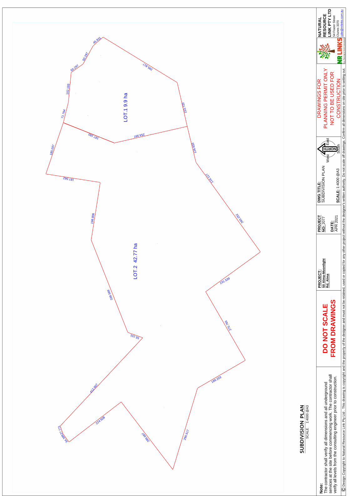
No
te:
The
con
trac
tor
shal
l ver
ify a
ll di
men
sion
s an
d al
l und
ergr
ound
serv
ices
at t
he s
ite b
efor
e co
mm
enci
ng w
ork.
The
con
trac
tor
shal
lve
rify
all l
evel
s fr
om th
e co
nsul
ting
engi
neer
prio
r to
con
stru
ctio
n.
DO
NO
T S
CA
LE
FR
OM
DR
AW
ING
S
DR
AW
ING
S F
OR
PLA
NN
ING
PE
RM
IT O
NLY
NO
T T
O B
E U
SE
D F
OR
CO
NS
TR
UC
TIO
N
SU
BD
IVIS
ION
P
LA
NS
CA
LE
1:
4000
@A
3
DW
G T
ITL
E:
SU
BD
IVIS
ION
PLA
N
SC
AL
E: 1
:400
0 @
A3
NA
TU
RA
LR
ES
OU
RC
EL
INK
PT
Y L
TD
54 F
raze
r S
tree
tC
lune
s 33
70ju
lie@
nrlin
ks.c
om.a
u C
Des
ign
Cop
yrig
ht t
o N
atur
al R
esou
rce
Link
Pty
Ltd
. T
his
draw
ing
is c
opyr
ight
and
the
pro
pert
y of
the
desi
gner
and
mus
t not
be
reta
ined
, use
d or
cop
ied
for
any
othe
r pr
ojec
t with
out t
he d
esig
ner's
writ
ten
auth
ority
. Do
not s
cale
off
draw
ings
. Con
firm
all
dim
ensi
ons
on s
ite p
rior
to s
ettin
g ou
t.NORTH
Eas
t
Sou
th
Wes
t
PR
OJE
CT
:50
Alm
a-M
oo
nlig
ht
Rd
, Alm
a
PR
OJE
CT
NO
: 20
77
DA
TE
:A
PR
202
1
LOT
.1 9
.9 h
a
LOT
.2 4
2.77
ha
71.7
6410
2.19
350.297
50.2
97
45.931
187.160 254.997
338.
589
153.
720
295.817
185.
037
187.562
198.
806
55.101
412.
907
27.7
71
34.3
99
224.508
289.
687
290.
517
189.203
270.
765
231.539
260.
252
116.
127
126.
633

Page 58 of 60
2077 50 Alma-Moonlight Road, Alma Feb 2021
APPENDIX.4. HOUSE PLAN
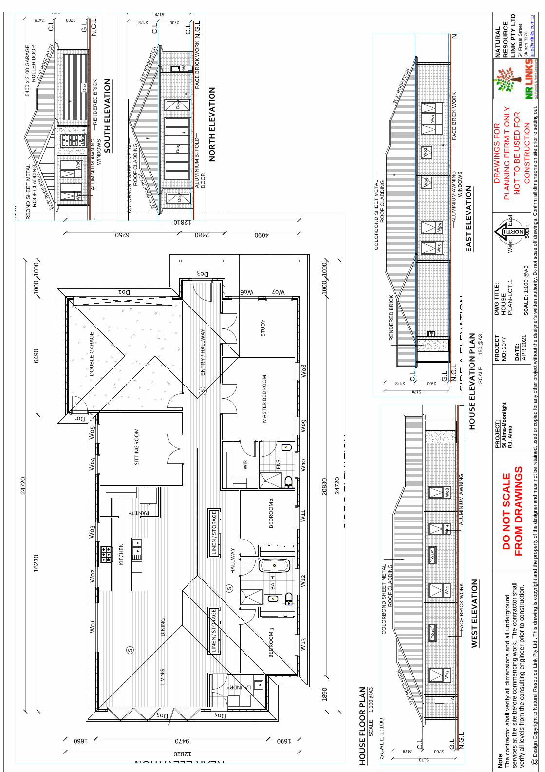
No
te:
The
con
trac
tor
shal
l ver
ify a
ll di
men
sion
s an
d al
l und
ergr
ound
serv
ices
at t
he s
ite b
efor
e co
mm
enci
ng w
ork.
The
con
trac
tor
shal
lve
rify
all l
evel
s fr
om th
e co
nsul
ting
engi
neer
prio
r to
con
stru
ctio
n.
DO
NO
T S
CA
LE
FR
OM
DR
AW
ING
S
DR
AW
ING
S F
OR
PLA
NN
ING
PE
RM
IT O
NLY
NO
T T
O B
E U
SE
D F
OR
CO
NS
TR
UC
TIO
N
DW
G T
ITL
E:
HO
US
EP
LA
N-L
OT
.1
SC
AL
E: 1
:100
@A
3
NA
TU
RA
LR
ES
OU
RC
EL
INK
PT
Y L
TD
54 F
raze
r S
tree
tC
lune
s 33
70ju
lie@
nrlin
ks.c
om.a
u C
Des
ign
Cop
yrig
ht t
o N
atur
al R
esou
rce
Link
Pty
Ltd
. T
his
draw
ing
is c
opyr
ight
and
the
pro
pert
y of
the
desi
gner
and
mus
t not
be
reta
ined
, use
d or
cop
ied
for
any
othe
r pr
ojec
t with
out t
he d
esig
ner's
writ
ten
auth
ority
. Do
not s
cale
off
draw
ings
. Con
firm
all
dim
ensi
ons
on s
ite p
rior
to s
ettin
g ou
t.NORTH
Eas
t
Sou
th
Wes
t
PR
OJE
CT
:50
Alm
a-M
oo
nlig
ht
Rd
, Alm
a
PR
OJE
CT
NO
: 20
77
DA
TE
:A
PR
202
1
HO
US
E F
LO
OR
PL
AN
SC
ALE
1:10
0 @
A3
HO
US
E E
LE
VA
TIO
N P
LA
N
SC
ALE
1:15
0 @
A3
SO
UT
H E
LE
VA
TIO
N
NO
RT
H E
LE
VA
TIO
N
WE
ST
EL
EV
AT
ION
EA
ST
EL
EV
AT
ION
S
S
S
DO
UB
LE G
AR
AG
E ST
UD
YM
AS
TE
R B
ED
RO
OM
BE
DR
OO
M 2
BE
DR
OO
M 3
SIT
TIN
G R
OO
M
KIT
CH
EN
PANTRY
HA
LL
WA
Y
LIN
EN
/ S
TO
RA
GE
LIN
EN
/ S
TO
RA
GE
LAUNDRY
EN
TR
Y /
HA
LLW
AY
DIN
ING
LIV
ING
BA
TH
WIR
EN
S.
W0
1W
02
W0
3W
04
W0
5
D01
W06 W07
W0
8W
09
W1
0W
11
W1
2W
13
D02
D03
D04D05
2472
0
1623
064
9010
0010
00
2472
0
1890
2083
010
0010
00
12820
169094701660
12810
409024806250
FRONT ELEVATION
REAR ELEVATIONS
IDE
A E
LEV
AT
ION
SID
E B
ELE
VA
TIO
N
SID
E A
ELE
VA
TIO
N
MB
N.G
.LG
.L
C.L
N.G
.L
27002478
5178
G.L
C.L
W0
1
W0
2W
03
W0
4W
05
FA
CE
BR
ICK
WO
RK
RE
ND
ER
ED
BR
ICK
CO
LOR
BO
ND
SH
EE
T M
ET
AL
RO
OF
CLA
DD
ING
ALU
MIN
IUM
AW
NIN
GW
IND
OW
S
22.5
° R
OO
F P
ITC
HHW
27002478
5178
N.G
.LG
.L
C.L
N.G
.L
D0
1D
05
D0
4
ALU
MIN
IUM
BI-
FO
LDD
OO
RF
AC
E B
RIC
K W
OR
K
CO
LOR
BO
ND
SH
EE
T M
ET
AL
RO
OF
CLA
DD
ING
22.5
° R
OO
F P
ITC
H22
.5°
RO
OF
PIT
CH
SC
ALE
1:1
00
N.G
.L
27002478
5178
G.L
C.L
N.G
.L
HW
W0
8W
09
W1
0
W1
1
W1
2
W1
3
FA
CE
BR
ICK
WO
RK
ALU
MIN
IUM
AW
NIN
GW
IND
OW
S
CO
LOR
BO
ND
SH
EE
T M
ET
AL
RO
OF
CLA
DD
ING
22.5
° R
OO
F P
ITC
H
SC
ALE
1:1
00
27002478
5178
N.G
.LG
.L
C.L
N.G
.L
W0
6W
07
D0
2D
03
ALU
MIN
IUM
AW
NIN
GW
IND
OW
SR
EN
DE
RE
D B
RIC
K
5400
x 2
100
GA
RA
GE
RO
LLE
R D
OO
RC
OLO
RB
ON
D S
HE
ET
ME
TA
LR
OO
F C
LAD
DIN
G
22.5
° R
OO
F P
ITC
H22
.5°
RO
OF
PIT
CH

No
te:
The
con
trac
tor
shal
l ver
ify a
ll di
men
sion
s an
d al
l und
ergr
ound
serv
ices
at t
he s
ite b
efor
e co
mm
enci
ng w
ork.
The
con
trac
tor
shal
lve
rify
all l
evel
s fr
om th
e co
nsul
ting
engi
neer
prio
r to
con
stru
ctio
n.
DO
NO
T S
CA
LE
FR
OM
DR
AW
ING
S
DR
AW
ING
S F
OR
PLA
NN
ING
PE
RM
IT O
NLY
NO
T T
O B
E U
SE
D F
OR
CO
NS
TR
UC
TIO
N
HO
US
E F
LO
OR
PL
AN
SC
ALE
1:10
0 @
A3
DW
G T
ITL
E:
HO
US
EP
LA
N-L
OT
.2
SC
AL
E: A
S N
OT
ED
NA
TU
RA
LR
ES
OU
RC
EL
INK
PT
Y L
TD
54 F
raze
r S
tree
tC
lune
s 33
70ju
lie@
nrlin
ks.c
om.a
u C
Des
ign
Cop
yrig
ht t
o N
atur
al R
esou
rce
Link
Pty
Ltd
. T
his
draw
ing
is c
opyr
ight
and
the
pro
pert
y of
the
desi
gner
and
mus
t not
be
reta
ined
, use
d or
cop
ied
for
any
othe
r pr
ojec
t with
out t
he d
esig
ner's
writ
ten
auth
ority
. Do
not s
cale
off
draw
ings
. Con
firm
all
dim
ensi
ons
on s
ite p
rior
to s
ettin
g ou
t.NORTH
Eas
t
Sou
th
Wes
t
PR
OJE
CT
:50
Alm
a-M
oo
nlig
ht
Rd
, Alm
a
PR
OJE
CT
NO
: 20
77
DA
TE
:A
PR
202
1
HO
US
E E
LE
VA
TIO
N P
LA
N
SC
ALE
1:15
0 @
A3
SO
UT
H E
LE
VA
TIO
N
EA
ST
EL
EV
AT
ION
NO
RT
H E
LE
VA
TIO
N
WE
ST
EL
EV
AT
ION
SID
E A
ELE
VA
TIO
NS
CA
LE 1
:100
2700
4822 SID
E B
ELE
VA
TIO
N
N.G
.LG
.L
C.L
2700
4822
N.G
.LG
.L
C.L
D0
5
W0
3W
04
W0
5
W0
6W
07
W0
8
22.5
° R
OO
F P
ITC
H22
.5°
RO
OF
PIT
CH
FA
CE
BR
ICK
WO
RK
ALU
MIN
IUM
AW
NIN
GW
IND
OW
S
CO
LOR
BO
ND
SH
EE
T M
ET
AL
RO
OF
CLA
DD
ING
FR
ON
T E
LEV
AT
ION
SC
ALE
1:1
00
2700
2700
4822
4822
N.G
.LG
.L
C.L
N.G
.LG
.L
C.L
D0
2
W0
9
22.5
° R
OO
F P
ITC
H22
.5°
RO
OF
PIT
CH
CO
LOR
BO
ND
SH
EE
T M
ET
AL
RO
OF
CLA
DD
ING
FA
CE
BR
ICK
WO
RK
ALU
MIN
IUM
AW
NIN
GW
IND
OW
S
KITCHEN
SIT
TIN
G R
OO
M
DIN
ING
LIV
ING
DO
UB
LE
GA
RA
GE
MA
ST
ER
BE
DR
OO
MB
ED
RO
OM
2B
ED
RO
OM
3
ST
UD
Y
EN
TR
Y
BA
TH
W.C
L'D
RY
820
720
720
72
0
82
0
82
0
LIN
EN
BR
M
RO
BE
RO
BE
EN
S.
W.I
.R720 720
SHR.REF
OHC OHC
820
PORTICO
82
0
820
82
0
1844
0
3530
6540
6470
950
950
SID
E A
ELE
VA
TIO
N
1844
0
1749
095
0
SID
E B
ELE
VA
TIO
N
16260
4380150043806000
FRONT ELEVATION
16260
761026506000
REAR ELEVATION
820
W01 W02
W0
3W
04
W0
5W
06
W0
7W
08
W09
D0
1
D02
D03 D04D
05
2700
4822 SID
E A
ELE
VA
TIO
N
N.G
.LG
.L
C.L
2700
4822
N.G
.LG
.L
C.L
D0
1
22.5
° R
OO
F P
ITC
H22
.5°
RO
OF
PIT
CH
CO
LOR
BO
ND
SH
EE
T M
ET
AL
RO
OF
CLA
DD
ING
FA
CE
BR
ICK
WO
RK
ALU
MIN
IUM
SLI
DIN
GD
OO
R
2700
2700
4822
4822
N.G
.LG
.L
C.L
N.G
.LG
.L
C.L
D0
3D
04
W0
1W
02
FA
CE
BR
ICK
WO
RK
22.5
° R
OO
F P
ITC
HC
OLO
RB
ON
D S
HE
ET
ME
TA
LR
OO
F C
LAD
DIN
G
ALU
MIN
IUM
AW
NIN
GW
IND
OW
S
22.5
° R
OO
F P
ITC
H

Page 59 of 60
2077 50 Alma-Moonlight Road, Alma Feb 2021
APPENDIX.5 CONSERVATION/FARM PLAN

No
te:
The
con
trac
tor
shal
l ver
ify a
ll di
men
sion
s an
d al
l und
ergr
ound
serv
ices
at t
he s
ite b
efor
e co
mm
enci
ng w
ork.
The
con
trac
tor
shal
lve
rify
all l
evel
s fr
om th
e co
nsul
ting
engi
neer
prio
r to
con
stru
ctio
n.
DO
NO
T S
CA
LE
FR
OM
DR
AW
ING
S
DR
AW
ING
S F
OR
PLA
NN
ING
PE
RM
IT O
NLY
NO
T T
O B
E U
SE
D F
OR
CO
NS
TR
UC
TIO
N
CO
NS
ER
VA
TIO
N P
LA
NS
CA
LE
1:2
000
@A
3
DW
G T
ITL
E:
CO
NS
ER
VA
TIO
NP
LA
N
SC
AL
E:
1:20
00 @
A3
NA
TU
RA
LR
ES
OU
RC
EL
INK
PT
Y L
TD
54 F
raze
r S
tree
tC
lune
s 33
70ju
lie@
nrlin
ks.c
om.a
u C
Des
ign
Cop
yrig
ht t
o N
atur
al R
esou
rce
Link
Pty
Ltd
. T
his
draw
ing
is c
opyr
ight
and
the
prop
erty
of t
he d
esig
ner
and
mus
t not
be
reta
ined
, use
d or
cop
ied
for
any
othe
r pr
ojec
t with
out t
he d
esig
ner's
writ
ten
auth
ority
. Do
not s
cale
off
draw
ings
. Con
firm
all
dim
ensi
ons
on s
ite p
rior
to s
ettin
g ou
t.
NORTH
Eas
t
Sou
th
Wes
t
PR
OJE
CT
:50
Alm
a-M
oo
nlig
ht
Rd
, Alm
a
PR
OJE
CT
NO
: 20
77
DA
TE
:A
PR
202
1
LEGEND
PR
OP
OS
ED
DW
ELLIN
G
LIN
E O
FIN
UN
DA
TIO
N
PR
OP
OS
ED
CO
NS
ER
VA
TIO
NP
RO
PO
SE
DW
IND
BR
EA
K(F
EN
CE
D)
INC
RE
AS
ET
OP
SO
IL
LAN
D U
SE
EX
IST
ING
PO
OR
DR
AIN
AG
E
NO
TE
: R
ISK
S T
O S
OIL
HE
ALT
H O
N S
ITE
AR
E D
ISP
ER
SIV
ES
OIL
S T
O T
HE
NO
RT
H, H
IGH
CO
MP
AC
TIO
N R
ISK
,M
OD
ER
AT
E L
EA
CH
ING
AN
D S
ALI
NIT
Y
SE
DG
E A
RE
AS
ON
SIT
E IN
DIC
AT
E P
OO
R D
RA
INA
GE
WH
ER
E S
OIL
S N
EE
D T
O B
E IM
PO
RO
VE
D W
ITH
GY
PS
UM
PR
OP
OS
ED
FE
NC
E
AR
EA
OF
PO
OR
DR
AIN
AG
E A
SS
HO
WN
BE
LOW
TO
BE
IMP
RO
VE
DW
ITH
TH
E U
SE
OF
GY
PS
UM
EF
FLU
EN
TP
RO
PO
SE
DA
CC
ES
S
2 74
MARYBOROUGH-STARNAUD R
OAD
ALL
WE
AT
HE
R
ADELAIDE LEAD-
ir rig
ated
past
u re
graz
ing /
fodd
erpa
stu r
e .4
graz
ing gr
azin
g
dom
est ic
dom
est ic
LINE OF INUNDATION
5052
750
192
ALL
WE
AT
HE
Rdo
mes
t ic
LINE OF INUNDATION
g ra z
i ng
graz
i ng
graz
ing
g ra z
i ng
LINE OF INUNDATION
dom
estic

No
te:
The
con
trac
tor
shal
l ver
ify a
ll di
men
sion
s an
d al
l und
ergr
ound
serv
ices
at
the
site
bef
ore
com
men
cing
wor
k. T
he c
ontr
acto
r sh
all
verif
y al
l lev
els
from
the
cons
ultin
g en
gine
er p
rior
to c
onst
ruct
ion.
DO
NO
T S
CA
LE
FR
OM
DR
AW
ING
S
DR
AW
ING
S F
OR
PLA
NN
ING
PE
RM
IT O
NLY
NO
T T
O B
E U
SE
D F
OR
CO
NS
TR
UC
TIO
N
EX
IST
ING
PL
AN
SC
ALE
1:50
00 @
A3
DW
G T
ITL
E:
FA
RM
MA
NA
GE
ME
NT
PLA
N
SC
AL
E: 1
:500
0 @
A3
NA
TU
RA
LR
ES
OU
RC
EL
INK
PT
Y L
TD
54 F
raze
r S
tree
tC
lune
s 33
70ju
lie@
nrlin
ks.c
om.a
u C
Des
ign
Cop
yrig
ht t
o N
atur
al R
esou
rce
Link
Pty
Ltd
. T
his
draw
ing
is c
opyr
ight
and
the
pro
pert
y of
the
desi
gner
and
mus
t not
be
reta
ined
, use
d or
cop
ied
for
any
othe
r pr
ojec
t with
out t
he d
esig
ner's
writ
ten
auth
ority
. Do
not s
cale
off
draw
ings
. Con
firm
all
dim
ensi
ons
on s
ite p
rior
to s
ettin
g ou
t.
NORTH
Eas
t
Sou
th
Wes
t
PR
OJE
CT
:50
Alm
a-M
oo
nlig
ht
Rd
, Alm
a
PR
OJE
CT
NO
: 20
77
DA
TE
:A
PR
202
1
LEGEND
PR
OP
OS
ED
DW
ELLIN
G
EX
IST
ING
DR
AIN
AG
EA
DD
SA
LIN
ET
OL
ER
AN
T T
RE
ES
EX
IST
ING
FE
NC
EP
RO
PO
SE
DW
IND
BR
EA
K(F
EN
CE
D)
INC
RE
AS
ET
OP
SO
IL
1 W
EE
KA
NN
UA
LG
RA
ZE
RE
ST
OR
EV
EG
ET
AT
ION
PR
OP
OS
ED
CO
MP
OS
TA
RE
A
NO
TE
: R
ISK
S T
O S
OIL
HE
ALT
H O
N S
ITE
AR
E D
ISP
ER
SIV
ES
OIL
S T
O T
HE
NO
RT
H,
HIG
H C
OM
PA
CT
ION
RIS
K,
MO
DE
RA
TE
LE
AC
HIN
G A
ND
SA
LIN
ITY
ER
OS
ION
ON
MIN
OR
WA
TE
RW
AY
ON
TH
E N
OR
TH
OF
TH
ES
ITE
PR
OP
OS
ED
FE
NC
E
MIT
IGA
TE
SO
IL R
ISK
BY
CH
AN
NE
LLIN
G R
UN
OF
F A
RO
UN
D IR
RIG
AT
ED
PA
DD
OC
KS
AN
D P
LAN
TIN
G H
IGH
SA
LIN
E T
OLE
RA
NT
TR
EE
S T
O U
SE
WA
TE
RT
HIS
WIL
L A
VO
ID I
NC
RE
AS
E I
N S
ALI
NE
WA
TE
R T
AB
LE.
ER
SO
SIO
N R
ISK
-LI
MIT
GR
AZ
ING
TO
BIO
MA
SS
CO
NT
RO
L, A
LLO
W F
OR
NA
TU
RA
L R
EG
EN
ER
AT
ION
- R
ED
UC
ES
FR
AG
ME
NT
AT
ION
ALL
PA
ST
UR
ES
TO
BE
IM
PR
OV
ED
WIT
H G
YP
SU
M O
R S
IMIL
AR
TO
IMP
RO
VE
DR
AIN
AG
E.
US
E S
PE
CIF
IED
RO
AD
S O
NLY
TO
ALL
P
AD
DO
CK
S T
O L
IMIT
TR
AF
FIC
MO
VE
ME
NT
.S
ALI
NIT
Y M
OD
ER
AT
E I
RR
IGA
TIO
N,
CO
NT
RO
L R
UN
OF
F A
ND
US
E O
FE
XC
ES
SIV
E R
UN
OF
F B
Y S
ALI
NE
TO
LER
AN
T T
RE
ES
.S
OIL
HA
S M
OD
ER
AT
E L
EA
CH
ING
SO
IN
CR
EA
SE
CA
RB
ON
IN S
OIL
AN
DIN
CR
EA
SE
NU
TR
IEN
TS
.IN
CR
EA
SE
SO
IL D
EP
TH
WIT
H C
OM
PO
ST
ING
TO
IMP
RO
VE
SO
IL C
ON
DIT
ION
AN
D C
AR
BO
N.
past
ure
gr a
zin
g/f o
dder
graz
ing*
LOT.
2 4
2.3
ha
LINE O
F INUNDATIO
N
35
36 37
34
33 3255
164
WA
LKE
RS
RO
AD
ALL W
EATHER
MA
RY
BO
RO
UG
H-S
TA
RN
AU
D R
OA
D
ALM
A-M
OO
NLI
GH
T R
OAD
ALL
WE
AT
HE
R
TRACK O
NLY
HARKIN COURT
ROAD RESERVE
41
1
irr ig
ated
past
ure
irr ig
ated
past
ure
graz
ing/
fodd
erpa
stur
e.2
graz
ing/
fodd
erpa
stur
e.3
graz
ing/
fodd
erpa
stur
e.1
graz
ing/
fodd
erpa
stur
e.4
graz
ing*
graz
ing
dom
esti c
LINE OF INUNDATION
LINE O
F INUNDATIO
N

Page 60 of 60
2077 50 Alma-Moonlight Road, Alma Feb 2021
APPENDIX.6 INTRODUCTION TO SODIC SOILS


