plate - university of chicago press€¦ · plate 9. page 1 of the codex xolotl, ca. 1542. (see p....
TRANSCRIPT
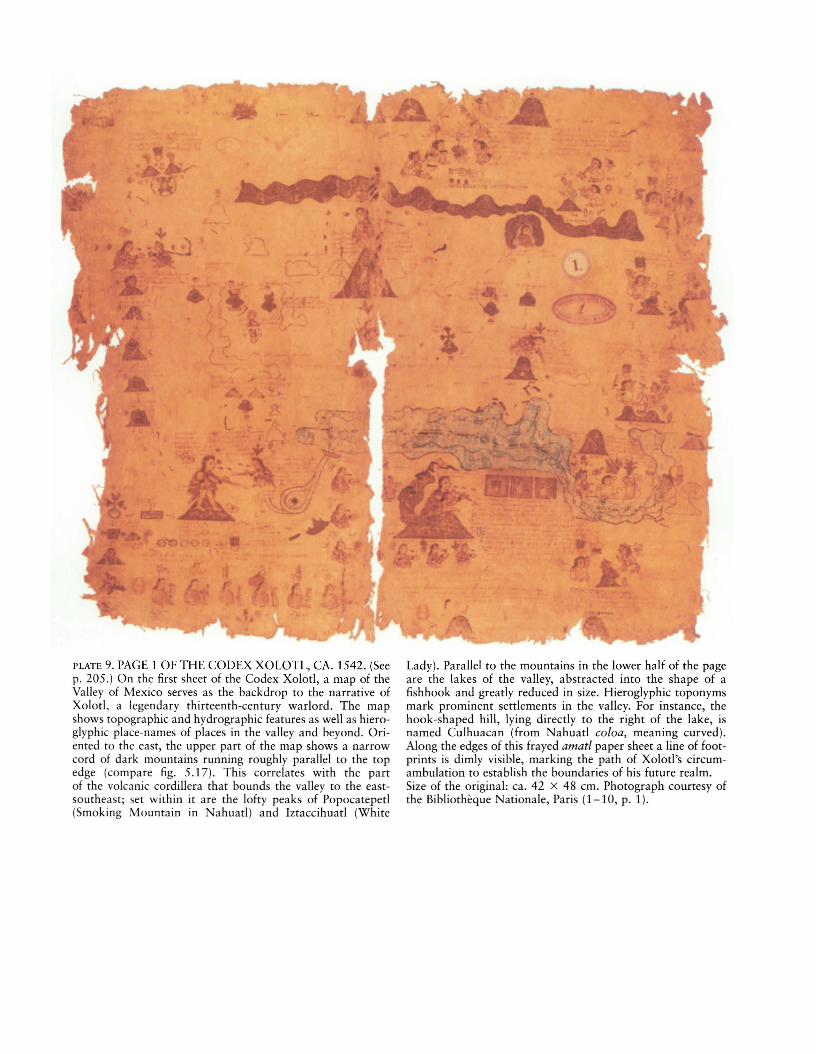
PLATE 9. PAGE 1 OF THE CODEX XOLOTL, CA. 1542. (Seep. 205.) On the first sheet of the Codex Xolotl, a map of theValley of Mexico serves as the backdrop to the narrative ofXolotl, a legendary thirteenth-century warlord. The mapshows topographic and hydrographic features as well as hieroglyphic place-names of places in the valley and beyond. Oriented to the east, the upper part of the map shows a narrowcord of dark mountains running roughly parallel to the topedge (compare fig. 5.17). This correlates with the partof the volcanic cordillera that bounds the valley to the eastsoutheast; set within it are the lofty peaks of Popocatepetl(Smoking Mountain in Nahuatl) and Iztaccihuatl (White
Lady). Parallel to the mountains in the lower half of the pageare the lakes of the valley, abstracted into the shape of afishhook and greatly reduced in size. Hieroglyphic toponymsmark prominent settlements in the valley. For instance, thehook-shaped hill, lying directly to the right of the lake, isnamed Culhuacan (from Nahuatl coloa, meaning curved).Along the edges of this frayed amatl paper sheet a line of footprints is dimly visible, marking the path of Xolotl's circumambulation to establish the boundaries of his future realm.Size of the original: ca. 42 X 48 em. Photograph courtesy ofthe Bibliotheque Nationale, Paris (1-10, p. 1).
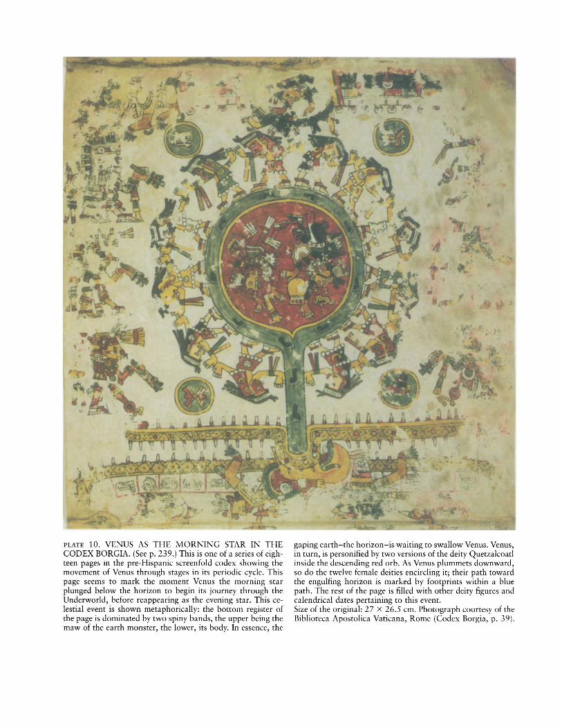
PLATE 10. VENUS AS THE MORNING STAR IN THECODEX BORGIA. (See p. 239.) This is one of a series of eighteen pages in the pre-Hispanic screenfold codex showing themovement of Venus through stages in its periodic cycle. Thispage seems to mark the moment Venus the morning starplunged below the horizon to begin its journey through theUnderworld, before reappearing as the evening star. This celestial event is shown metaphorically: the bottom register ofthe page is dominated by two spiny bands, the upper being themaw of the earth monster, the lower, its body. In essence, the
gaping earth-the horizon-is waiting to swallow Venus. Venus,in turn, is personified by two versions of the deity Quetzalcoatlinside the descending red orb. As Venus plummets downward,so do the twelve female deities encircling it; their path towardthe engulfing horizon is marked by footprints within a bluepath. The rest of the page is filled with other deity figures andcalendrical dates pertaining to this event.Size of the original: 27 X 26.5 cm. Photograph courtesy of theBiblioteca Apostolica Vaticana, Rome (Codex Borgia, p. 39).

PLATE 11. MAPA DE SANTA CRUZ. (See p. 244.) This postconquest manuscript map on skin is a rare depiction of theValley of Mexico. The indigenous artist was undoubtedlyinfluenced by European city maps, which would have beenavailable in this busy capital of the Spanish colony. The twincities of Tlatelolco and Tenochtitlan are greatly enlarged atcenter, allowing the viewer to pick out emblematic architec-
ture, most of it religious, such as the Tlatelolco monastery atthe right center. The landscape that unrolls around the centralcity is filled with small genre scenes: boatmen netting birds andfish, herders rounding up sheep and cattle, porters bending under loads.Size of the original: ca. 75 X 114 em. Photograph courtesy ofthe Universitetsbibliotek, Uppsala.
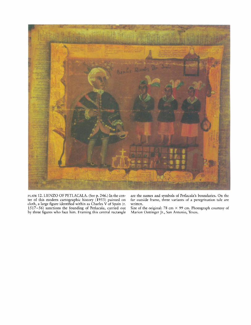
PLATE 12. LIENZO OF PETLACALA. (See p. 246.) In the center of this modern cartographic history (1953) painted oncloth, a large figure identified within as Charles V of Spain (r.1517-56) sanctions the founding of Petlacala, carried outby three figures who face him. Framing this central rectangle
are the names and symbols of Petlacala's boundaries. On thefar outside frame, three variants of a peregrination tale arewritten.Size of the original: 78 em x 99 em. Photograph courtesy ofMarion Oettinger Jr., San Antonio, Texas.

PLATE 13. COSMIC FERTILITY MAPPED BY BIA OF THETUKANO. (See p. 307.) The positioning of men, women, andcelestial bodies encodes the natural order of society. The central motif is the sun, and above is a snake design of yellow diamond shapes split in half. To the right of the snake appears arow of dots indicating insemination; the group of multicoloreddiamonds represents women. The two yellow, double-scrollmotifs to the left of the snake are male symbols, while below
the sun are clustered the wooden stools of the men whose ritual songs help sustain the regeneration of the universe.From Gerardo Reichel-Dolmatoff, Beyond the Milky Way:Hallucinatory Imagery of the Tukano Indians (Los Angeles:UCLA Latin American Center Publications, 1978), pI. 1. Bypermission of Gerardo Reichel-Dolmatoff Foundation, Bogota, Colombia.
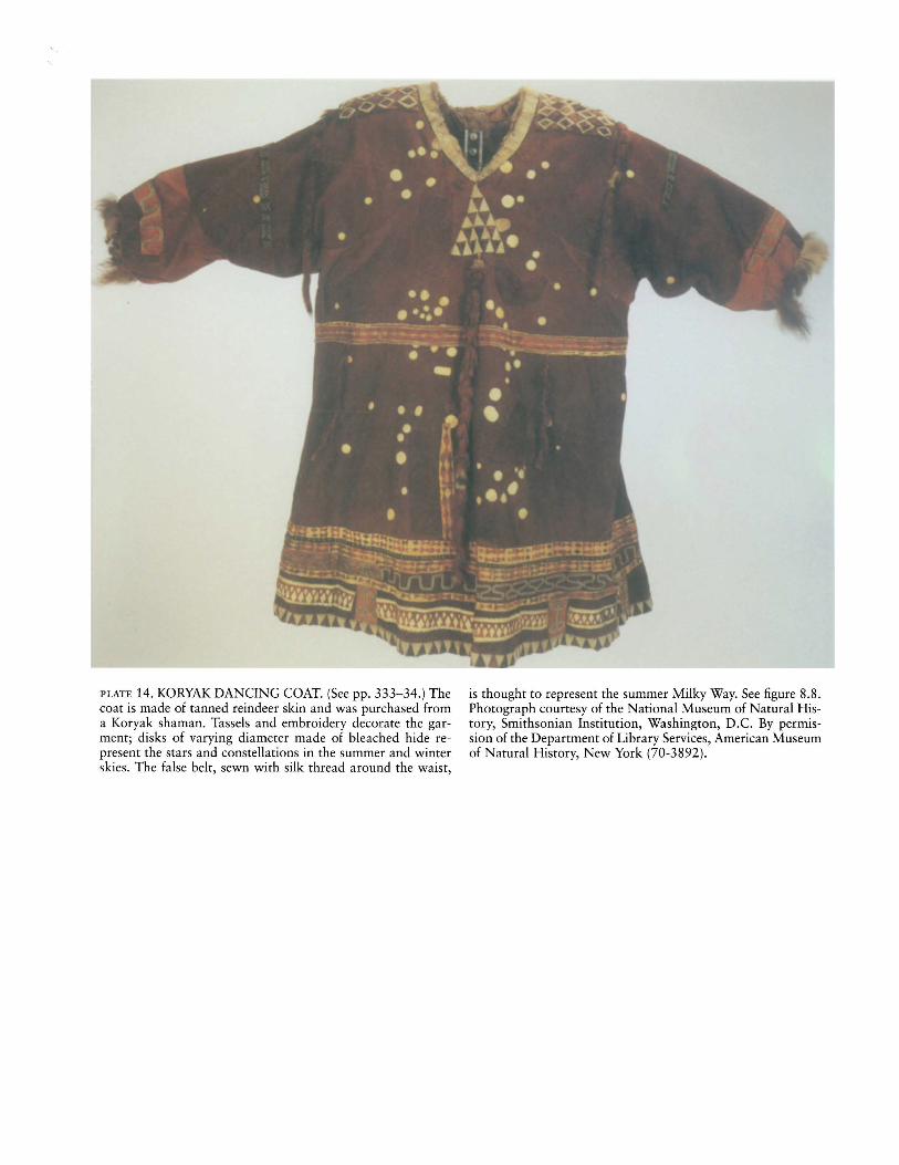
PLATE 14. KORYAK DANCING COAT. (See pp. 333-34.) Thecoat is made of tanned reindeer skin and was purchased froma Koryak shaman. Tassels and embroidery decorate the garment; disks of varying diameter made of bleached hide represent the stars and constellations in the summer and winterskies. The false belt, sewn with silk thread around the waist,
is thought to represent the summer Milky Way. See figure 8.8.Photograph courtesy of the National Museum of Natural History, Smithsonian Institution, Washington, D.C. By permission of the Department of Library Services, American Museumof Natural History, New York (70-3892).

PLATE 15. "X-RAY" IMAGE OF SALTWATER TURTLE,WESTERN ARNHEM LAND, CA. 1884. (See p. 366.)Ochers on bark, taken from a camp on Field Island, near
South Alligator River, by Captain F. Carrington in 1884.Size of the original: 83 X 63.5 em. Photograph courtesy of theSouth Australian Museum, Adelaide (A45559).

PLATE 16. WATER HOLES AT JILA JAPINGKA AND PAJPARA WITH PARALLEL SAND HILLS, 1987. (See p. 367.)Acrylic painting on canvas, fila ]apingka, made by Peter Skipper for sale. See figure 9.8.
Size of the original: 181.5 X 120.5 em. Photograph courtesyof the South Australian Museum, Adelaide. By permission ofPeter Skipper, c/o Duncan Kentish Fine Art, P.O. Box 629,North Adelaide, South Australia.
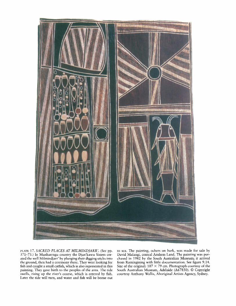
PLATE 17. SACRED PLACES AT MILMIND]ARR'. (See pp.371-73.) In Manharrngu country the Djan'kawu Sisters created the well Milmindjarr' by plunging their digging sticks intothe ground, then had a ceremony there. They were looking forfish and caught a small catfish, which is also represented in thispainting. They gave birth to the peoples of the area. The tideswells, rising up the river's course, which is entered by fish.Later the tide will turn, and water and fish will be borne out
to sea. The painting, ochers on bark, was made for sale byDavid Malangi, central Arnhem Land. The painting was purchased in 1982 by the South Australian Museum; it arrivedfrom Ramingining with little documentation. See figure 9.14.Size of the original: 107 X 79 em. Photograph courtesy of theSouth Australian Museum, Adelaide (A67850). © Copyrightcourtesy Anthony Wallis, Aboriginal Artists Agency, Sydney.

PLATE 18. DJARRAKPI LANDSCAPE. (See p. 373.) Painting,ochers on bark, made for an ethnographic collector by Banapana Maymuru, northeast Arnhem Land. For three interpre-
tations of the painting, see figure 9.15. Photograph courtesy ofHoward Morphy.
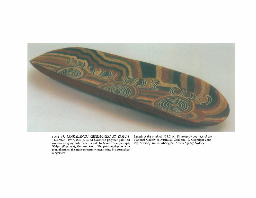
PLATE 19. PANKALANGU CEREMONIES AT YAMUNTURNGA, 1987. (See p. 379.) Synthetic polymer paint onwooden carrying dish made for sale by Sonder Nampitjinpa,Walpiri (Papunya), Western Desert. The painting depicts ceremonial camps; the arcs represent women sitting in a formal arrangement.
Length of the original: 131.2 cm. Photograph courtesy of theNational Gallery of Australia, Canberra. © Copyright courtesy Anthony Wallis, Aboriginal Artists Agency, Sydney.

PLATE 20. VARIOUS TOAS, CA. 1904. (See p. 383.) Ocherson wood from Killalpaninna Lutheran Mission, South Australia, made for an ethnographic collector.
Heights of the originals: 19 to 57 em. Photograph courtesy ofthe South Australian Museum, Adelaide.

PLATE 21. MAP OF THE GOROMURU (GURRUMURU)RIVER AREA. (See pp. 402-3.) Drawn by Djimbun andMattjugi, northeast Arnhem Land, 1970. Pencil and felt-tippen on paper.
Private collection. © Copyright courtesy Anthony Wallis, Aboriginal Artists Agency, Sydney.

',1 f" ...
f·
'. .
l··;'. ~- . .:: ..
~ ';'~'\. ... '. .__ #-t
_ _ 1 ,
. \
\\. .
-.- ",-""",~): \..... - ...
-.'. '.
!
PLATE 22. DETAIL OF THE PORT OF MACASSAR BYMUNGGERAUI (MUNGGURRAWUY). (See pp. 412-13.)Yirrkala, northeast Arnhem Land, 1947. Crayon on paper.
Photograph by J. E. Stanton, courtesy of the Berndt Museumof Anthropology, Perth (WU6970). © Copyright courtesy Anthony Wallis, Aboriginal Artists Agency, Sydney.

PLATE 23. THREE MOUNTAINS OF THE IATMUL MAlRITUAL, REPRESENTING THE THREE TOTEMIC REGIONS OF THE WORLD. (See pp. 439-40.) The photographshows a tall platform, from which the rnai spirits will descendand dance among women and children. The backdrop of theplatform, woven from leaves and strips of bamboo, representsthree mountains, the three totemic regions of the world createdby the first ancestors of each of the three main clans in the vil-
lages. Kombrangowi Mountain is the region of the world thatlies to the south of the Sepik River. Mayviimbiit Mountain isthe land that spreads to the north of the river. The third is Woliagwi Mountain, which represents the ocean and distant islands. In the foreground are men preparing for the rnai ritual;atop the platform are the masked and costumed rnai dancers.By permission of Eric Kline Silverman.

PLATE 24. HAND SKETCH OF THE SOUTH PART OF THE MIDDLE (SOUTH) ISLAND BY MANTELL, CA. 1848-52. (See p. 521.)This map incorporates the basic information on the five lakes, whichwere drawn in Walter Baldock Durrant Mantell's Sketchbook No.2by Te Ware Korari (figs. 14.28-14.30). The names of these lakes areTekapo (Tekapa; Takapa), Takamoana (the Maori name for smallLake Alexandrina, which empties via smaller Lake McGregor into
Lake Tekapo), Wakarukumoana (Whakarukumoana; the Maori namesfor Lake McGregor), Pukaki (Piikaki), and Ohau (Ghau; Ghou). Themap also shows Mantell's track from Otago Harbour to Kaiapoi.Size of the original: 21 X 20 em. Photograph courtesy of the Alexander Turnbull Library, National Library of New Zealand, Te PunaMatauranga 0 Aotearoa, Wellington (834caq/ca.1848/acc. no.23,676).