p.m. city council regular meeting packet
TRANSCRIPT

City Council Regular Meeting Packet
SEPTEMBER 27, 2021 WORKSESSION PACKET.PDF
City Council Worksession Agenda
SEPTEMBER 27, 2021 WORKSESSION AGENDA.PDF
1. 5:00 P.M.
Documents:
2. 5:00 P.M.
Documents:

City Council Agenda - Worksession Monday, September 27, 2021, 5:00 p.m.
Council Worksession Room
1. 2.
CALL TO ORDER ROLL CALL
3. COUNCIL BUSINESS and/or DISCUSSION ITEMS 3.1 3.2 3.3 3.4
Discussion; Trunk Highway 10 Project; Neighborhood Traffic Impacts. (Example: Pleasant/Wingfield/Garfield) Discussion; River Lane Public Easement. Discussion; Development Update: * 2nd Avenue & Van Buren Street (Developer will be in attendance) * 4th Avenue and Grant Street * River Lane Vacant Lot * North Street Area East of 7th Avenue * 2612 4th Avenue Discussion; Flag Ordinance.
4. ADJOURNMENT
Members of the Anoka City Council may participate remotely in City Council meetings by interactive technology rather than by being physically present. Members of the public who desire to give input or testimony remotely may do so by calling or texting in comments prior to meetings at (763) 220-9005 or by email at: [email protected]. Members of the public may also monitor and participate in meetings remotely by attending via video conference (Zoom Webinar). The Zoom Webinar link will be posted prior to the meeting on the City of Anoka's website calendar at: https://www.anokaminnesota.com/calendar.aspx?CID=14. To access the link, from the online calendar, find the correct meeting date and click "More Details." Meetings by telephone or other electronic means in accordance with Minnesota Statute 13D.021.
Page 1 of 14
COUNCIL WORKSESSION MEMO Agenda Items #3.1
Meeting Date: September 27, 2021
Agenda Section: Council Business and/or Discussion Items
Item Description: Submitted By:
Discussion; Trunk Highway 10 Projects; Neighborhood Traffic Impacts
Ben Nelson, Engineering Technician
BACKGROUND INFORMATION
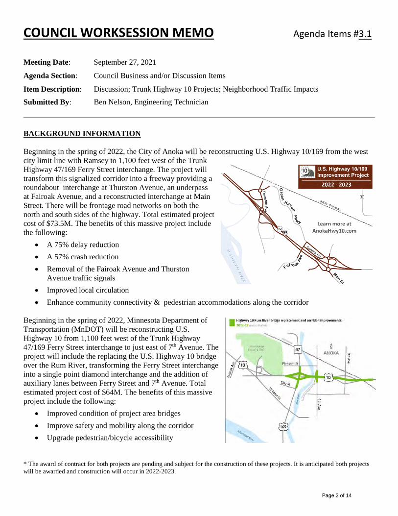
Beginning in the spring of 2022, the City of Anoka will be reconstructing U.S. Highway 10/169 from the west city limit line with Ramsey to 1,100 feet west of the Trunk Highway 47/169 Ferry Street interchange. The project will transform this signalized corridor into a freeway providing a roundabout interchange at Thurston Avenue, an underpass at Fairoak Avenue, and a reconstructed interchange at Main Street. There will be frontage road networks on both the north and south sides of the highway. Total estimated project cost of $73.5M. The benefits of this massive project include the following:
• A 75% delay reduction• A 57% crash reduction• Removal of the Fairoak Avenue and Thurston
Avenue traffic signals• Improved local circulation• Enhance community connectivity & pedestrian accommodations along the corridor
Beginning in the spring of 2022, Minnesota Department of Transportation (MnDOT) will be reconstructing U.S. Highway 10 from 1,100 feet west of the Trunk Highway 47/169 Ferry Street interchange to just east of 7th Avenue. The project will include the replacing the U.S. Highway 10 bridge over the Rum River, transforming the Ferry Street interchange into a single point diamond interchange and the addition of auxiliary lanes between Ferry Street and 7th Avenue. Total estimated project cost of $64M. The benefits of this massive project include the following:
• Improved condition of project area bridges• Improve safety and mobility along the corridor• Upgrade pedestrian/bicycle accessibility
* The award of contract for both projects are pending and subject for the construction of these projects. It is anticipated both projectswill be awarded and construction will occur in 2022-2023.
Page 2 of 14

The highway improvements occurring in 2022-2023 will require the adjacent roadway networks to absorb an influx of traffic that will be detoured around the construction. As part of the planning for these massive projects; MnDOT, Anoka County, and the City of Anoka developed a regional traffic management plan for this area during construction. As part of this plan, MnDOT, Anoka County, and the City will be completing or has completed the following projects prior to the construction of U.S. Highway 10: Green Haven Parkway Phase II (Led by City of Anoka): This project included the construction of a new
parkway between Verndale Avenue and Fairoak Avenue. This section of roadway completes the backage road connection on the north side of Highway 10 and will be a primary detour route.
7th Avenue Mill & Overlay Improvements (led by Anoka County): This project includes the mill & overlay of 7th Avenue from Buchanan Street to 600 feet north of 38th Lane. This section of roadway will be a primary diversion route between Highway 10 to Bunker Lake Boulevard.
Highway 47 & County Road 116/Bunker Lake Blvd Intersection Improvements (led by Anoka County): This project included increased intersection capacity for Bunker Lake Boulevard and Highway 47. Both of these roadways will be primary diversion routes.
Bunker Lake Blvd Improvements from Armstrong Blvd to Sunfish Lake Blvd (led by Anoka County): This project will include the addition of designated turn lanes, increased length of merge lanes, restrictions of left turning movements onto Bunker Lake Boulevard and the installation of a permanent traffic signal system at the Sunwood Drive intersection. It has been estimated that traffic volumes on Bunker Lake Boulevard will double during peak travel times.
Highway 47/169 (Ferry St) Resurfacing Project (led by MnDOT): This project includes resurfacing Highway 47 from the south end of the Mississippi River to Clay Street and from Pleasant Street to just south of Industry Avenue/Bunker Lake Boulevard. This section of roadway will be a primary diversion route to the Anoka-Champlin Bridge.
Highway 47 (St. Francis Blvd) & McKinley St Temporary Signal (led by MnDOT): This project includes the pavement widening along the east shoulder of Highway 47 to accommodate a dedicated left turn and a thru/right turn lane to McKinley Street. A temporary signal will be installed at the intersection of Highway 47 and McKinley Street. This intersection incudes 3-legs of the signal that are primary routes.
7th Avenue Interchange Improvements at Highway 10 (led by MnDOT): This project will include the realignment of the Highway 10 westbound exit ramp to align with Pierce Street with a temporary signal. The eastbound exit ramp from Highway 10 will be widened to accommodate a “button hook ramp” from southbound 7th Avenue to eastbound Highway 10. This will be a primary location to access Highway 10.
Pleasant Avenue/Pierce Street/4th Avenue Temporary Signal (led by MnDOT): This project will include a temporary signal at the intersection of Pleasant Avenue/Pierce Street and 4th Avenue. All legs of this intersection are critical routes through the construction.
Intelligent Transportation System Technology (led by MnDOT): This will include the installation of message boards regionally to inform motorists of the delays to expect if they continue towards Highway 10 as well as travel times via alternative routes.
Council shall be aware that these massive construction projects will have a substantial effect on the operational performance of the highways and local roads leading to an increase in congestion and delay during construction. After the completion of the projects, corridor capacity will be significantly improved. There is an advantage of the MnDOT and the City coordinating the construction of the two projects which include; greater ability to reduce and manage traffic disruptions, a cost savings for both agencies, and a shorter construction schedule.
Page 3 of 14

DISCUSSION
The local roads within the City of Anoka will be affected by all the construction during 2022-2023. Staff is examining any and all solutions on what can be done to minimize non-local traffic within our local neighborhoods. Dan Lonnes, a Principal Engineer with Bolton Menk, will present a PowerPoint on local neighborhood traffic impacts, the options and tools to mitigate these concerns and will help address council questions. It shall be noted, any change in local circulation could lead to unintended consequences to the traffic patterns in other areas of the City. Council shall be aware that when construction begins the new/changed traffic patterns of the local commuters due to these impacts will “normalize” within 3-4 days. Generally, what has been observed with the existing traffic is that it will equally (one third); disappear/“goes away”, find an alternate route, or continue using the same route. FINANCIAL IMPACT N/A REQUESTED COUNCIL ACTION Staff is seeking feedback and direction on the framework for managing local traffic impacts through the Highway 10 construction in 2022-2023. Staff will answer questions on any aspects associated with the Highway 10 projects.
Page 4 of 14

COUNCIL WORKSESSION MEMO Agenda Item # _________
Meeting Date: September 27, 2021
Agenda Section: Council Business and/or Discussion Items
Item Description: Discussion; River Lane Public Easement
Submitted By: Doug Borglund, Community Development Director
BACKGROUND INFORMATION As you may recall, in November of 2017, a resident had brought forward concerns regarding the ability to utilize an existing 30-foot public walkway easement that is located between existing single-family residential parcels known as 442 River Lane and 502 River Lane at the end of 5th Avenue.
The existing 30-foot walkway easement was put in place in 1979 at the time of platting the subdivision known as Sandra Terrace, allowing public access to the Mississippi River between 442 River Lane and 502 River Lane.
The current property owner of 502 River Lane during the time-period of 2007-2008 (according to the property owner) constructed a retaining wall and stairway with a majority of the private improvement located in the existing drainage, utility, and walkway easement area.
After the November Anoka City Council work session meeting, the City received a petition to vacate the existing walkway easement from the owners of property adjacent to the existing easement that is directly impacted on December 26, 2017.
• The City Council discussed this item on November 27, 2017 at its regular work session meeting. Theitem was continued to the January 22, 2018.
• The City Council discussed this item on January 22, 2018. The Council consensus was to review theissue and bring it back for discussion in the future.
• The City Council again discussed this issue on August 27, 2018, with the consensus to investigate andmove in a direction that would grant access to only the neighborhood. Since that time, the owners of 502River Lane worked with a private attorney to create a new walkway easement exclusively for the purposeof providing access from River Lane to the Mississippi River over the westerly 15 feet of Lot 10, Block 1Sandra Terrace and 7 feet of easement for walkway purposes over the existing staircase on Lot 10, Block1 Sandra Terrace.
• On May 8, 2020, a Quit Claim Deed from the owners of 502 River Lane, the Grantors, was recorded,allowing exclusive access and permission to the following properties, to walk on the easement and use theGrantors’ dock to access the Mississippi River: Lots 1, 2, 3, 3A, 4, and 4A, Block 1 and Lots 1 ,2, 3,Block 2 of the Sandra Terrace subdivision. A copy of this Quit Claim Deed is enclosed for your review.In exchange for granting this easement, the owners of 502 River Lane expected the City would vacate theoriginal public easement.
3.2
Page 5 of 14

• On September 8, 2020, the Anoka City Council held a Public Hearing on the vacation of the original public access easement, with many of the property owners who had received the easement from the owners of 502 River Lane attending and requesting that the City not vacate the public easement. The City Council voted to not vacate the existing access easement.
As a result, there are now 2 easements on the owner of 502 River Lane’s property, each providing for the same access. Since it was the desire of those neighborhood property owners who had received the exclusive easement for the City to continue the public easement access, those owners were requested to Quit Claim Deed the previous exclusive easement back to the property owners of 502 River Lane to remove the duplicative easements.
• On June 17, 2021 a letter was sent out by the City, which enclosed a Quit Claim Deed that would have
simply conveyed back the easement to the property owners of 502 River Lane. Because of a limited response to execute and return the signed Quit Claim Deeds for affected properties. This issue is being brought back to the City Council for discussion and further direction. Only one (1) out of six (6) affected property owners returned a sign Quit Claim Deed back to the City.
(NOTE: The property owners that had received quit claim deeds from the City have been invited to attend the meeting.)
FINANCIAL IMPACT
N/A
COUNCIL DIRECTION REQUESTED Provide direction to City Staff.
Page 6 of 14

Page 7 of 14

COUNCIL WORKSESSION MEMO Agenda Item # _________
Meeting Date: September 27, 2021
Agenda Section: Council Business and/or Discussion Item
Item Description: Discussion; Development Update
Submitted By: Doug Borglund, Community Development Director
BACKGROUND INFORMATION City Staff will discuss with the following items:
• 2nd Avenue & Van Buren Street: Discuss a proposed concept development of high-density residentialmixed-use development concept and tax increment analysis for the 2nd and Van Buren site. TheDeveloper will be present to interact with the City Council. Ehlers will be present to talk about TIF.
• 4th Avenue and Grant Street: The discussion will include an update on development interest and gettingdirection from the City Council.
• River Lane Vacant Lot: There has been interest the subject property to build a single-family home.Since there has been a change indirection to develop this area as low density. Does the Council haveinterest in selling this lot or continuing to retain it for a future use?
• North Street Area East of 7th Avenue: The former Dustbusters site is for sale on North Street. Theowner has approached the City to find out if there is interest in acquisition before the site goes on themarket.
• 2612 4th Avenue: City interest in acquisition.
(Note: Background information will be presented at the meeting.)
FINANCIAL IMPACT N/A
COUNCIL DIRECTION REQUESTED City Council provide direction to City Staff.
3.3
Page 8 of 14

COUNCIL WORKSESSION MEMO Agenda Item # _________
Meeting Date: September 27, 2021
Agenda Section: Council Business and/or Discussion Items
Item Description: Discussion; Flag Ordinance
Submitted By: Doug Borglund, Community Development Director
BACKGROUND INFORMATION Enclosed for City Council’s review and discussion is a draft amendment to the City Code that would regulate the display of flags or similar objects or displays on City of Anoka owned buildings, sites, parks, community signs, light poles, and flagpoles, etc.
FINANCIAL IMPACT N/A
COUNCIL DIRECTION REQUESTED Provide direction to City Staff.
3.4
Page 9 of 14

Chapter 54 - STREETS, SIDEWALKS AND OTHER PUBLIC PLACES
ARTICLE VIII. DISPLAY OF FLAGS OR SIMILAR OBJECTS OR DISPLAYS ON CITY OWNED PROPERTY
Sec. 54-341. Purpose; applicability
The purpose of this article is to provide a way for the city too;
(1) Regulate the display of flags or similar objects on City of Anoka owned buildings, sites, parks, community message signs, light poles and flagpoles.
(2) Assure that anything displayed on City owned buildings, sites, parks, community message signs, light poles, flagpoles, or other City infrastructure only illustrates a form of governmental expression of the City of Anoka.
Sec. 54-342. Definitions.
The following words, terms, and phrases, when used in this section, shall have the meanings ascribed to them in this section, except where the context clearly indicates a different meaning:
City means the City of Anoka, Minnesota.
City Property means City owned buildings, sites, parks, community message signs, light poles, flag poles, and other similar sites and structures owned by the City.
Sec. 54-343. Display of Flags or Similar Objects on City Property
(a) In addition to the display of the official flag of the United States of America, the City may display such additional flags or similar objects on City Property.
(b) City Property is not intended to serve as a forum for free expression by the public. Rather, City Property is to be used exclusively by the City, where the City may display a commemorative flag or similar objects as a form of government expression. The City shall not display a commemorative flag or similar objects based on a request from a third party, nor shall the City use City Property to sponsor the expression of a third party or show religious preference.
(c) No person shall display or place upon any City Property any flag, artwork, sign, or
similar objects or displays not otherwise authorized by the City as an expression of government speech.
(d) Owing to their very nature as expressive locations meant for contemplation and
reflection, such as monuments, memorials, and other similar structures or sites built as a remembrance shall not be deemed locations for expressive flags or similar objects of a third party.
Page 10 of 14

(e) In addition to the official flag of the United States of America and such other flags or similar objects as may be authorized by the Anoka City Council, the following flags or similar objects are hereby permitted to be displayed upon City Property, upon approval of the Anoka City Council, as a form of expression of government speech, in the manner set forth above:
(1) Flag of the State of Minnesota. (2) P.O.W./M.I.A. (Prisoner of War/Missing in Action)) flag as provided in Title 36, Chapter 9, § 902 of the United State Code (36 U.S.C.A. § 902). (3) Flags representing all branches of US Military Forces
(4) Flag of the City of Anoka
(5) Banners on light poles reflective of City of Anoka, holidays, seasons, or celebrations.
(6) Official flags of the United States of America on street light poles.
(7) Community message signs
(8) City park or facility name permanent identification signage.
(9) Temporary signage/banners for City of Anoka events or activities displayed by the City.
(10) Color of backlighting of City of Anoka logo on Hwy 10 bridge decks or colored lighting of Main Street bridge as determined by the City.
(11) Displays, memorials, or artwork designed and/or approved by the City.
(f) The official flag of the United States of America shall always be displayed highest and any such additional flags shall be flown below the flag of the United States. The flag of the United States shall be displayed in accordance with and in the manner prescribed in Chapter 1 of Title 4 of the United States Code (4 U.S.C.A. §§ 1 to 10)
(g) Nothing contained herein is intended to abridge the right of the citizens of the City of
Anoka to petition or request the Anoka City Council to authorize an expression of government speech.
Sec. 54-344 Display of Flags at Half-Mass on City Property
(a) United States of America flags shall only fly at half-mast when the President of the
United States issues an order specifying that all states, at all government offices and/or at all public buildings are ordered to do so.
(b) State of Minnesota flags shall only fly at half-mast when the Governor of Minnesota issues an order specifying that all Minnesota government offices and all Minnesota public buildings are ordered to do so.
Page 11 of 14

Page 12 of 14

Page 13 of 14
Page 14 of 14

City Council Agenda - Worksession Monday, September 27, 2021, 5:00 p.m.
Council Worksession Room
1. 2.
CALL TO ORDER ROLL CALL
3. COUNCIL BUSINESS and/or DISCUSSION ITEMS 3.1 3.2 3.3 3.4
Discussion; Trunk Highway 10 Project; Neighborhood Traffic Impacts. (Example: Pleasant/Wingfield/Garfield) Discussion; River Lane Public Easement. Discussion; Development Update: * 2nd Avenue & Van Buren Street (Developer will be in attendance) * 4th Avenue and Grant Street * River Lane Vacant Lot * North Street Area East of 7th Avenue * 2612 4th Avenue Discussion; Flag Ordinance.
4. ADJOURNMENT
Members of the Anoka City Council may participate remotely in City Council meetings by interactive technology rather than by being physically present. Members of the public who desire to give input or testimony remotely may do so by calling or texting in comments prior to meetings at (763) 220-9005 or by email at: [email protected]. Members of the public may also monitor and participate in meetings remotely by attending via video conference (Zoom Webinar). The Zoom Webinar link will be posted prior to the meeting on the City of Anoka's website calendar at: https://www.anokaminnesota.com/calendar.aspx?CID=14. To access the link, from the online calendar, find the correct meeting date and click "More Details." Meetings by telephone or other electronic means in accordance with Minnesota Statute 13D.021.