policy unit 5c14 redbridge to calshot spit
TRANSCRIPT
North Solent Shoreline Management Plan
232
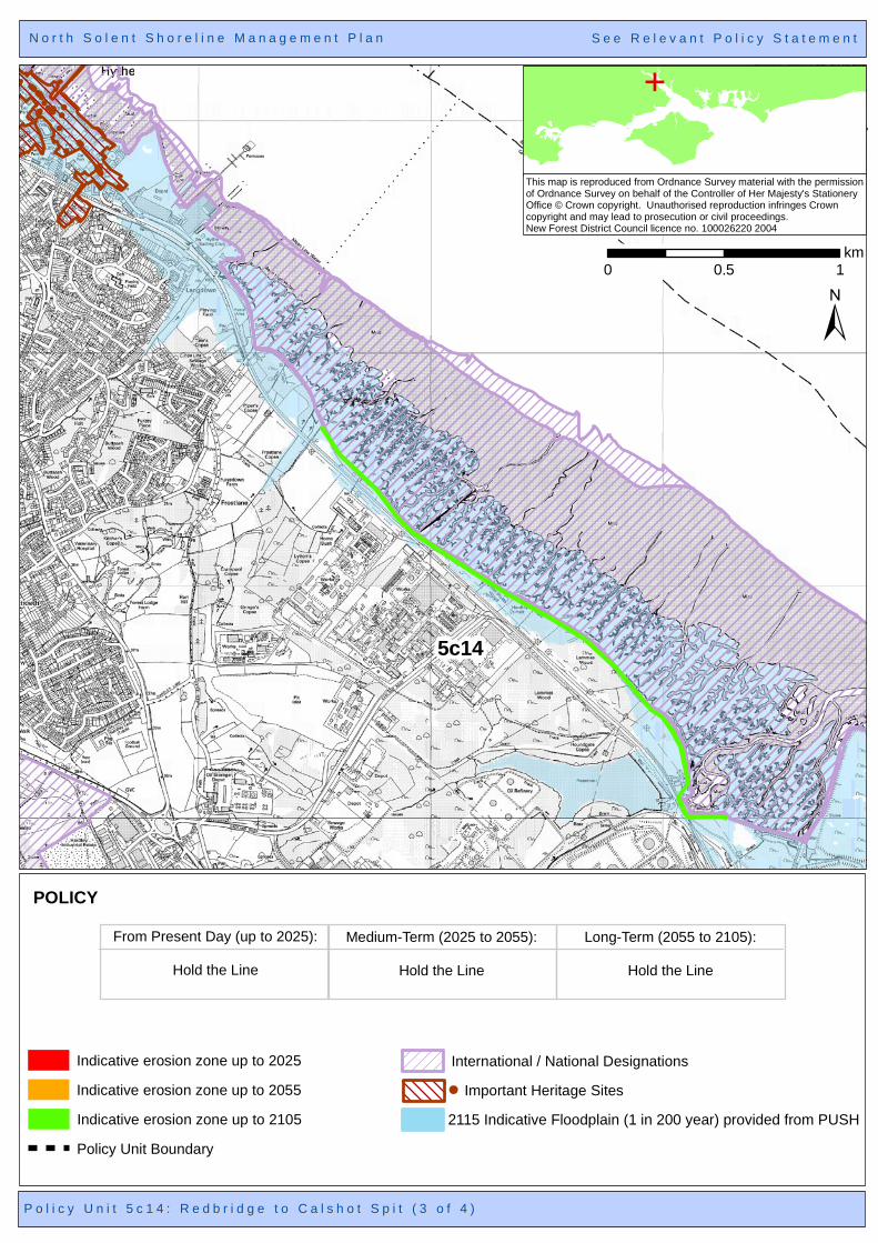
Policy Unit 5C14 Redbridge to Calshot Spit Summary description of Policy Unit The majority of this frontage is an industrial frontage, with pockets of residential development at Fawley, Hythe, Marchwood, Eling, and Totton. It contains Power Stations at Fawley and Marchwood; an Oil Refinery plant; a Military Port and associated infrastructure; a former landfill/reclaimed land site; residential marina development, quay and promenade; heritage facilities (e.g. Eling Tide Mill) and assets. ABP Southampton are the statutory harbour authority and owns significant parts of the water frontage within Southampton Water, including the Dibden reclaim frontage; this site has been subject to recent (refused) port development proposals. There are locally important transport links across Southampton Water. The majority of the existing flood defences are privately owned and maintained, although there are short lengths maintained by the Local Authority and MOD. The frontage from Fawley to Calshot Spit is included within the New Forest National Park Authority, excluding Fawley Power Station. The tidal floodplain is relatively restricted due to the topography, but extends further inland at Hythe and Marchwood, affecting transport networks, properties, and access. The majority of the frontage length has inter-tidal habitats of International, European and national nature conservation importance; the frontage between Marchwood and Hythe (Dibden Bay area) also has neutral grassland with freshwater habitats at West Cliff marsh. These habitats provide important high tide roost sites and support the adjacent and nearby SPA/Ramsar sites. There is a Wildlife Trust Reserve south east of Hythe and a Local Nature Reserve in the lee of Calshot Spit. At Bury, Eling, Fawley and in the lee of Calshot Spit are relatively short lengths of eroding saltmarsh. Neutral grassland habitat at Dibden Bay, on reclaimed land, is privately owned by the Port Authority and included in recent port development proposals. Heritage assets include listed buildings, Conservation Areas and maritime features.
Final policy options
SMP1 Ref TEST5,3,2,1& FAW5, 4,3 Hold the Line
TEST4 No Active Intervention FAW6 Managed Realignment
Epoch 1 From Present Day
(up to 2025)
Epoch 2 Medium Term (2025 to 2055)
Epoch 3 Long Term
(2055 to 2105) Hold the Line
Hold the Line Hold the Line
Summary of rationale behind final policy options Maintaining the current line of defence along the west bank of Southampton Water will afford protection to the regionally and nationally significant industrial and commercial developments, assets and infrastructure and the residential centres including Fawley, Hythe, Marchwood, Eling, and Totton. Heritage features are also located within the coastal flood risk area. Protection of such areas will provide significant benefits to the local and regional economy. The Dibden reclaimed site has been identified as a potential site for future port development in the Port Master Plan. It is the intention that undefended shoreline frontages continue to be undefended. Property level flood defences may be appropriate where flood risk will increase in the longer-term. Due to the environmental designations within Southampton Water, maintaining the defence line will continue to contribute towards the loss of European and national
North Solent Shoreline Management Plan
233
nature conservation designated habitats such as inter-tidal foreshore habitats, through coastal squeeze. These losses will need to be mitigated within the same designated area or compensated for elsewhere and delivered through the Regional Habitat Creation Programme. Opportunities for habitat mitigation and compensation have been detailed within the Appropriate Assessment of the final policies. Policy changes through Public Consultation
None. Funding It is likely that central government funding could be secured for the majority of identified works on Local authority maintained defences. As is currently the case, no public funding would be available for continued maintenance of defences by private owners or for the privately-owned port and industrial frontages. Further Studies (identified in Action Plan) Conclusion of the Western Solent Coastal Defence Strategy Redbridge to Calshot Flood and Coastal Erosion Risk Management Strategy Solent-wide network of high tide roost site study

5c14
5c12
N o r t h S o l e n t S h o r e l i n e M a n a g e m e n t P l a nN o r t h S o l e n t S h o r e l i n e M a n a g e m e n t P l a n
±
E
This map is reproduced from Ordnance Survey material with the permission of Ordnance Survey on behalf of the Controller of Her Majesty's StationeryOffice © Crown copyright. Unauthorised reproduction infringes Crowncopyright and may lead to prosecution or civil proceedings.New Forest District Council licence no. 100026220 2004
0 0.5 1km
P o l i c y U n i t 5 c 1 4 : R e d b r i d g e t o C a l s h o t S p i t ( 1 o f 4 )P o l i c y U n i t 5 c 1 4 : R e d b r i d g e t o C a l s h o t S p i t ( 1 o f 4 )
S e e R e l e v a n t P o l i c y S t a t e m e n tS e e R e l e v a n t P o l i c y S t a t e m e n t
POLICY
From Present Day (up to 2025):
Hold the Line
Medium-Term (2025 to 2055):
Hold the Line
Long-Term (2055 to 2105):
Hold the Line
2115 Indicative Floodplain (1 in 200 year) provided from PUSH
International / National Designations
Indicative erosion zone up to 2055
Policy Unit Boundary
Indicative erosion zone up to 2025
Indicative erosion zone up to 2105
Important Heritage Sites

5c14
N o r t h S o l e n t S h o r e l i n e M a n a g e m e n t P l a nN o r t h S o l e n t S h o r e l i n e M a n a g e m e n t P l a n
±
E
This map is reproduced from Ordnance Survey material with the permission of Ordnance Survey on behalf of the Controller of Her Majesty's StationeryOffice © Crown copyright. Unauthorised reproduction infringes Crowncopyright and may lead to prosecution or civil proceedings.New Forest District Council licence no. 100026220 2004
0 0.5 1km
P o l i c y U n i t 5 c 1 4 : R e d b r i d g e t o C a l s h o t S p i t ( 2 o f 4 )P o l i c y U n i t 5 c 1 4 : R e d b r i d g e t o C a l s h o t S p i t ( 2 o f 4 )
S e e R e l e v a n t P o l i c y S t a t e m e n tS e e R e l e v a n t P o l i c y S t a t e m e n t
POLICY
From Present Day (up to 2025):
Hold the Line
Medium-Term (2025 to 2055):
Hold the Line
Long-Term (2055 to 2105):
Hold the Line
2115 Indicative Floodplain (1 in 200 year) provided from PUSH
International / National Designations
Indicative erosion zone up to 2055
Policy Unit Boundary
Indicative erosion zone up to 2025
Indicative erosion zone up to 2105
Important Heritage Sites
5c14
5c09
N o r t h S o l e n t S h o r e l i n e M a n a g e m e n t P l a nN o r t h S o l e n t S h o r e l i n e M a n a g e m e n t P l a n
±
E
This map is reproduced from Ordnance Survey material with the permission of Ordnance Survey on behalf of the Controller of Her Majesty's StationeryOffice © Crown copyright. Unauthorised reproduction infringes Crowncopyright and may lead to prosecution or civil proceedings.New Forest District Council licence no. 100026220 2004
0 0.5 1km
P o l i c y U n i t 5 c 1 4 : R e d b r i d g e t o C a l s h o t S p i t ( 3 o f 4 )P o l i c y U n i t 5 c 1 4 : R e d b r i d g e t o C a l s h o t S p i t ( 3 o f 4 )
S e e R e l e v a n t P o l i c y S t a t e m e n tS e e R e l e v a n t P o l i c y S t a t e m e n t
POLICY
From Present Day (up to 2025):
Hold the Line
Medium-Term (2025 to 2055):
Hold the Line
Long-Term (2055 to 2105):
Hold the Line
2115 Indicative Floodplain (1 in 200 year) provided from PUSH
International / National Designations
Indicative erosion zone up to 2055
Policy Unit Boundary
Indicative erosion zone up to 2025
Indicative erosion zone up to 2105
Important Heritage Sites

5c14
N o r t h S o l e n t S h o r e l i n e M a n a g e m e n t P l a nN o r t h S o l e n t S h o r e l i n e M a n a g e m e n t P l a n
±
E
This map is reproduced from Ordnance Survey material with the permission of Ordnance Survey on behalf of the Controller of Her Majesty's StationeryOffice © Crown copyright. Unauthorised reproduction infringes Crowncopyright and may lead to prosecution or civil proceedings.New Forest District Council licence no. 100026220 2004
0 0.5 1km
P o l i c y U n i t 5 c 1 4 : R e d b r i d g e t o C a l s h o t S p i t ( 4 o f 4 )P o l i c y U n i t 5 c 1 4 : R e d b r i d g e t o C a l s h o t S p i t ( 4 o f 4 )
S e e R e l e v a n t P o l i c y S t a t e m e n tS e e R e l e v a n t P o l i c y S t a t e m e n t
POLICY
From Present Day (up to 2025):
Hold the Line
Medium-Term (2025 to 2055):
Hold the Line
Long-Term (2055 to 2105):
Hold the Line
2115 Indicative Floodplain (1 in 200 year) provided from PUSH
International / National Designations
Indicative erosion zone up to 2055
Policy Unit Boundary
Indicative erosion zone up to 2025
Indicative erosion zone up to 2105
Important Heritage Sites