pore pressure detection and risk assessment of obl oil ... · pore pressure detection and ris...
TRANSCRIPT

105
Matthew E. Nton*, Mosopefoluwa D. AyeniUniversity of Ibadan, Department of Geology, Nigeria*Corresponding author. E-mail: [email protected]; [email protected]
Received: May 8, 2014
Accepted: December 22, 2014
Original scientific paper
Abstract The Niger Delta is a prolific petroleum sedimentary basin in the Gulf of Guinea and is posed with a major challenge of overpressure development in many of its fields. Integrated study, utilising 3D seismic data and well logs from four wells, namely; OBL_1, OBL_2, OBL_4 and OBL_5 was carried out in the offshore Niger Delta. The study aims at evaluation of structural influences on pressure development, detection of overpressure zones and consequently examining the risk involved in drilling. Log signatures show decrease in density log values and corresponding increase in sonic log read-ings in wells OBL_1, OBL_2 and OBL_4. Well OBL_5, re-veals increase density log values but decrease sonic log readings. Two regional and few minor faults observed to penetrate the overpressure zones were mapped out and integrated with the surfaces of the tops of the over pressured zones to generate three stratigraphic zones. Aside from under compaction mechanism, the region-al faults penetrating the surfaces generated across the overpressure intervals could have influenced pressure development in the wells.
Key words: pore pressure, risk assessment, Niger Delta
IzvlečekZa vrsto naftnih polj v bogatem naftnem območju delte reke Nigra v Gvinejskem zalivu je značilen pojav viso-kih pritiskov. Na predobalnem delu Nigrove delte so izvedli kompleksno raziskavo na osnovi tridimenzio-nalne seizmike in karotažnih podatkov iz štirih vrtin, in sicer OBL_1, OBL_2, OBL_4 in OBL_5. Namen je bil oceniti vplive geološke zgradbe na razvijanje pritiskov, ugotoviti prostorsko porazdelitev pritiska in določi-ti stopnjo tveganja pri globinskem vrtanju. Karotažni podatki pričajo o manjšanju gostote in s tem poveza-nim naraščanjem zvočnih karotažnih meritev v vrtinah OBL_1, OBL_2 in OBL_4. Nasprotno so v vrtini OBL_5 ugotovili naraščanje vrednosti gostotnih in zmanjševa-nje zvočnih karotažnih meritev. Dva regionalna in ne-kaj manjših prelomov, ki potekajo čez pasove visokih pritiskov, so kartirali in povezali s podatki iz teh pasov ter opredelili tri stratigrafske cone. Ugotovili so, da ute-gnejo vplivati na razvijanje visokih pritiskov v vrtinah razen mehanizma kompakcije tudi regionalni prelomi, ki potekajo čez intervale pod visokim pritiskom.
Ključne besede: porni pritisk, ocena tveganja, Nigrova delta
Pore pressure detection and risk assessment of obl oil field, offshore Niger delta, NigeriaUgotavljanje pornega pritiska in ocenitev tveganja v naftnem polju obl v predobalnem delu Nigrove delte v Nigeriji

Nton, M. E., Ayeni, M. D.
106
RMZ – M&G | 2015 | Vol. 62 | pp. 105–115
Introduction
Drilling in an overpressure zone without taking precautionary measures can pose serious chal-lenges. Hydrocarbon within the pore structures of sedimentary rocks tend to migrate from high pressured zones to relatively low pressured zones of a basin. However, if the formation is isolated or laterally sealed by impermeable clay or shale bed, such that pressure cannot be dissipated through connected pores to regions of low pressure, the formation remains under abnormally high pressure [1]. High pore pressure fluids are encountered worldwide in formations ranging in ages from Paleozoic to Cenozoic era and may be encoun-tered in shale-sand sequences and/ or carbon-ate-evaporite sections at depths ranging from a few 100 m below the earth’s surface to depths exceeding 6 100 m [2]. Therefore as explora-tion and exploitation of hydrocarbon move into deeper water environment, pore pressure analysis has become an important asset in the team’s planning process [3].Pore pressure analysis serves as a useful tool in many areas. In exploration, it is useful for detecting presence of hydrocarbon seals, map-ping of hydrocarbon pathways, analysing trap configuration and for basin modelling. It also serves as a great tool in drilling as it helps in understanding mechanisms and influences of overpressure development on hydrocarbon ac-cumulation [4]. For example; almost half of the gas production in the South Louisiana (Tertia-ry) in USA has been from a 600 m thick interval around the top of abnormal pressure zone [5]. Authors [6–8] established that the best zone to look for gas accumulation is in the over pres-sure region and in the formations above such area. In line with this assertion, it becomes nec-essary to critically examine pore pressure anal-ysis as an integral procedure in exploration.Like most petroliferous sedimentary basins in the world, the Niger Delta basin is posed with the challenge of overpressure development in most of its oil fields [9]. This study therefore at-tempts to evaluate the influence of structures on pore pressure development, detection of over pressure zones as well as examine drilling risks in the Niger Delta Basin, Nigeria.
Study area and regional geology setting
The study area, OBL field, lies between Lati-tudes 4˚ N–6˚ N and Longitudes 4˚ E–9˚ E in the south western offshore region of Niger Delta, Nigeria (Figure 1) and falls within the Chev-ron Nigeria Limited Concession. The base map showing location of study wells is shown on Figure 2.
In the Niger Delta, clastic wedges were de-posited along the failed arm of a triple junc-tion system. Originally, the Delta was formed during the break-up of the South American and African plates during the Late Jurassic [10, 11].
Figure 1: Location map of the study area. [Modified from 33, 34]
Figure 2: Base map of the study area produced using Petrel software.

Pore pressure detection and risk assessment of obl oil field, offshore Niger delta, Nigeria
107
The two rift arms that followed the southwest-ern and southeastern coasts of Nigeria and Cameroon developed into the passive continen-tal margin of West Africa; whereas, the third failed arm formed the Benue Trough which is located under the Gulf of Guinea, offshore Ni-geria. After an early history of rift filling in the Mesozoic, the clastic wedge steadily prograded into the Gulf of Guinea during the Tertiary as drainage expanded into the African craton with consequent subsidence of the passive margin. These upward- coarsening strata, offlapping the continental margin (Niger Delta), have been divided into three diachronous litho-stratigraphic units, namely from oldest to youngest; the Akata, Agbada and Benin Forma-tions (Figure 3; [12, 13]). The Akata Formation is the oldest of the units and comprised mainly marine shales which range in age from Eocene to Recent. The Agbada Formation overlies the Akata Formation and made up of alternating deltaic sandstones with shale. Its age ranges from Eocene to Recent. The Benin Formation is the youngest in the lithostratigraphic succes-sion, and comprises sandstone, grits, claystone and streaks of lignite. Its age ranges from Oligo-cene to Recent. The Niger Delta is subtly disturbed at the sur-face but the subsurface is affected by large scale synsedimentary features such as growth faults, rollover anticlines and diapirs [13, 14]. The struc-tural style, both on regional and on field scale, can be explained on the basis of influence of the ratio of sedimentation to subsidence rates. The different types of structures are namely, sim-ple non-faulted anticline rollover structures, faulted rollover anticline with multiple growth faults or anticline faults and complicated col-lapse crest structures [15]. Others are sub-paral-lel growth fault (k-block structures) and struc-tural closures along the back of major growth faults (Figure 4)Continental-margin collapse structures ex-ert control on depositional and stratigraphic patterns within the Niger Delta clastic wedge (Figure 4). At the largest scale, these structures extend laterally along depositional strike near-ly across the entire Niger Delta (hundreds of kilometers), defining ‘‘mega structures’’ [15] and associated ‘‘depobelts’’ that are tens of kilome-ters wide perpendicular to the shoreline [13, 16].
Six regional depobelts were deposited during the 25 million years from early Miocene to pres-ent. Depobelts tend to become finer-grained, laterally away from areas of most rapid delta progradation and basin ward away from areas of most rapid growth fault development [13].
Figure 3: Stratigraphic columns of the three formations in the Niger Delta [13].
Figure 4: Examples of Niger Delta oil field structures and associated trap types[13, 14].

Nton, M. E., Ayeni, M. D.
108
RMZ – M&G | 2015 | Vol. 62 | pp. 105–115
Smaller-scale faults and associated structural deformation accommodating collapse of depo-belts tend to be more complex near the progra-dational axis of the delta than at its margins. This pattern of deposition continues still today, with extensional development of growth faults on the modern shelf and slope and compres-sional uplift near the toe of the slope [17, 18].
Materials and methods of study
Data AcquisitionThe data set utilized in this study were ac-quired from Chevron Nigeria Limited, Lagos, Nigeria and comprised 3-D seismic volume in SEG-Y format and well logs in LAS format. Four wells namely, OBL_1, OBL_2, OBL_4 and OBL_5 with relative positions across 2D seismic sur-vey as shown in Figure 2 were used. The com-posite logs utilized include among others; gam-ma ray, sonic, density and resistivity logs. The 3-D seismic volume on the other hand covers in-lines and cross lines ranges of 5 800 to 6200 and 1480 to 1700 respectively.
Methods of StudyThe methods of study entailed analysis of the data set by integration of petrel software with well logs and 3D seismic volume for strati-graphic and seismic interpretations. Lithology delineation and well correlation were done by observing gamma ray log signatures across the four wells. Similarly, readings on density and sonic logs were observed for overburden assessment and delineation of overpressure intervals respectively. Major and minor faults were picked at intervals of 10 on in lines and reflected on the cross lines across the planes on the seismic section (Figure 5). Synthetic seismogram was generated across the study wells and was utilized in seismic-well tie; thus, enhancing picking of seismic horizons across seismic section for generation of time structur-al contour maps.
Results and discussion
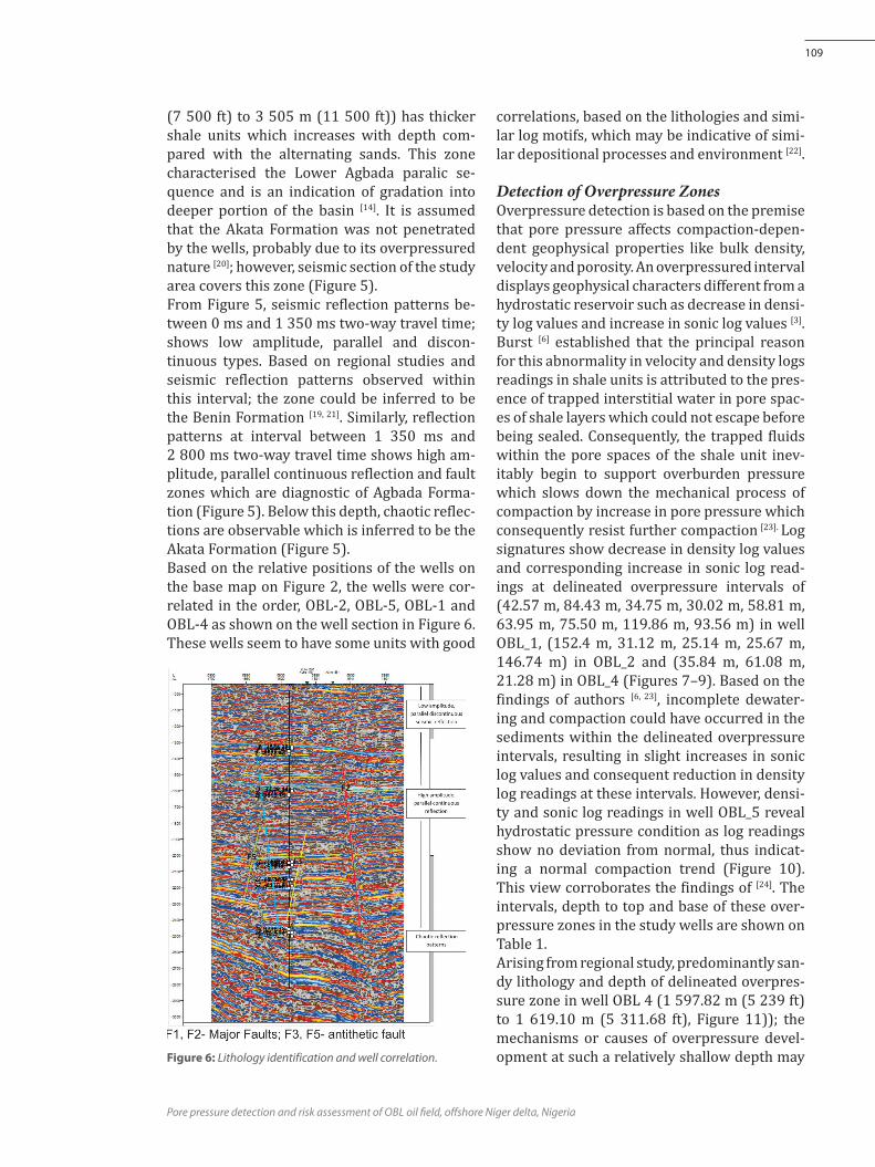
Lithology Identification and Well CorrelationIn lithology identification across wells OBL 1, OBL 2, OBL 4 and OBL 5; increase and decrease from the baseline on gamma ray log were in-terpreted as shale and sand intervals respec-tively. The four wells located within the study area penetrated two distinct lithological zones; as depicted by the litholog on the second track of the wells (Figure 6). Zones with yellow and dotted patterns indicate sand unit, while zones with black and dash-line patterns indicate shale units. Zone one (1) lies between 0 m and 1 676 m ( 0–5 500 ft) and is composed predominantly of sand unit. Based on the blocky signature of the gamma ray log and the predominantly sandy lithology, the zone could be inferred to be the Benin Formation [19]. Zone two (2) extends from 1 676 m (5 500 ft) to about 3 505 m (11 500 ft) which can be further delineated into upper and lower sections as reported by Doust and Omat-sola [13]. The upper section (1 676 m (5 500 ft) to 2 286 m (7 500 ft)) shows thicker sand inter-vals compared to the alternating shale laminae which may be indicative of the upper Agbada paralic sequence based on the concept of [13]. The lower section on the other hand (2 286 m
Figure 5: Seismic and fault interpretations of the study area.
Pore pressure detection and risk assessment of obl oil field, offshore Niger delta, Nigeria
109
(7 500 ft) to 3 505 m (11 500 ft)) has thicker shale units which increases with depth com-pared with the alternating sands. This zone characterised the Lower Agbada paralic se-quence and is an indication of gradation into deeper portion of the basin [14]. It is assumed that the Akata Formation was not penetrated by the wells, probably due to its overpressured nature [20]; however, seismic section of the study area covers this zone (Figure 5). From Figure 5, seismic reflection patterns be-tween 0 ms and 1 350 ms two-way travel time; shows low amplitude, parallel and discon-tinuous types. Based on regional studies and seismic reflection patterns observed within this interval; the zone could be inferred to be the Benin Formation [19, 21]. Similarly, reflection patterns at interval between 1 350 ms and 2 800 ms two-way travel time shows high am-plitude, parallel continuous reflection and fault zones which are diagnostic of Agbada Forma-tion (Figure 5). Below this depth, chaotic reflec-tions are observable which is inferred to be the Akata Formation (Figure 5).Based on the relative positions of the wells on the base map on Figure 2, the wells were cor-related in the order, OBL-2, OBL-5, OBL-1 and OBL-4 as shown on the well section in Figure 6. These wells seem to have some units with good
correlations, based on the lithologies and simi-lar log motifs, which may be indicative of simi-lar depositional processes and environment [22].
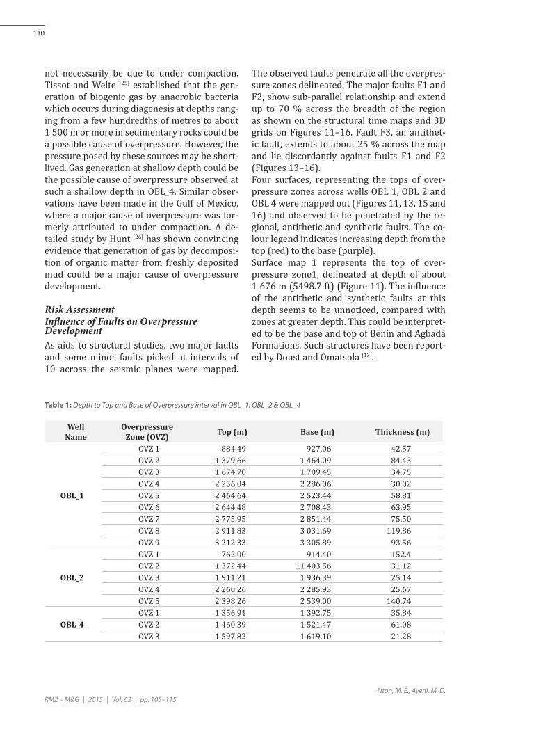
Detection of Overpressure ZonesOverpressure detection is based on the premise that pore pressure affects compaction-depen-dent geophysical properties like bulk density, velocity and porosity. An overpressured interval displays geophysical characters different from a hydrostatic reservoir such as decrease in densi-ty log values and increase in sonic log values [3]. Burst [6] established that the principal reason for this abnormality in velocity and density logs readings in shale units is attributed to the pres-ence of trapped interstitial water in pore spac-es of shale layers which could not escape before being sealed. Consequently, the trapped fluids within the pore spaces of the shale unit inev-itably begin to support overburden pressure which slows down the mechanical process of compaction by increase in pore pressure which consequently resist further compaction [23]. Log signatures show decrease in density log values and corresponding increase in sonic log read-ings at delineated overpressure intervals of (42.57 m, 84.43 m, 34.75 m, 30.02 m, 58.81 m, 63.95 m, 75.50 m, 119.86 m, 93.56 m) in well OBL_1, (152.4 m, 31.12 m, 25.14 m, 25.67 m, 146.74 m) in OBL_2 and (35.84 m, 61.08 m, 21.28 m) in OBL_4 (Figures 7–9). Based on the findings of authors [6, 23], incomplete dewater-ing and compaction could have occurred in the sediments within the delineated overpressure intervals, resulting in slight increases in sonic log values and consequent reduction in density log readings at these intervals. However, densi-ty and sonic log readings in well OBL_5 reveal hydrostatic pressure condition as log readings show no deviation from normal, thus indicat-ing a normal compaction trend (Figure 10). This view corroborates the findings of [24]. The intervals, depth to top and base of these over-pressure zones in the study wells are shown on Table 1.Arising from regional study, predominantly san-dy lithology and depth of delineated overpres-sure zone in well OBL 4 (1 597.82 m (5 239 ft) to 1 619.10 m (5 311.68 ft), Figure 11)); the mechanisms or causes of overpressure devel-opment at such a relatively shallow depth may Figure 6: Lithology identification and well correlation.
Nton, M. E., Ayeni, M. D.
110
RMZ – M&G | 2015 | Vol. 62 | pp. 105–115
not necessarily be due to under compaction. Tissot and Welte [25] established that the gen-eration of biogenic gas by anaerobic bacteria which occurs during diagenesis at depths rang-ing from a few hundredths of metres to about 1 500 m or more in sedimentary rocks could be a possible cause of overpressure. However, the pressure posed by these sources may be short-lived. Gas generation at shallow depth could be the possible cause of overpressure observed at such a shallow depth in OBL_4. Similar obser-vations have been made in the Gulf of Mexico, where a major cause of overpressure was for-merly attributed to under compaction. A de-tailed study by Hunt [26] has shown convincing evidence that generation of gas by decomposi-tion of organic matter from freshly deposited mud could be a major cause of overpressure development.
Risk AssessmentInfluence of Faults on Overpressure DevelopmentAs aids to structural studies, two major faults and some minor faults picked at intervals of 10 across the seismic planes were mapped.
Table 1: Depth to Top and Base of Overpressure interval in OBL_1, OBL_2 & OBL_4
The observed faults penetrate all the overpres-sure zones delineated. The major faults F1 and F2, show sub-parallel relationship and extend up to 70 % across the breadth of the region as shown on the structural time maps and 3D grids on Figures 11–16. Fault F3, an antithet-ic fault, extends to about 25 % across the map and lie discordantly against faults F1 and F2 (Figures 13–16). Four surfaces, representing the tops of over-pressure zones across wells OBL 1, OBL 2 and OBL 4 were mapped out (Figures 11, 13, 15 and 16) and observed to be penetrated by the re-gional, antithetic and synthetic faults. The co-lour legend indicates increasing depth from the top (red) to the base (purple).Surface map 1 represents the top of over-pressure zone1, delineated at depth of about 1 676 m (5498.7 ft) (Figure 11). The influence of the antithetic and synthetic faults at this depth seems to be unnoticed, compared with zones at greater depth. This could be interpret-ed to be the base and top of Benin and Agbada Formations. Such structures have been report-ed by Doust and Omatsola [13].
WellName
overpressureZone (OVZ) Top (m) Base (m) Thickness (m)
obl_1
OVZ 1 884.49 927.06 42.57OVZ 2 1 379.66 1 464.09 84.43OVZ 3 1 674.70 1 709.45 34.75OVZ 4 2 256.04 2 286.06 30.02OVZ 5 2 464.64 2 523.44 58.81OVZ 6 2 644.48 2 708.43 63.95OVZ 7 2 775.95 2 851.44 75.50OVZ 8 2 911.83 3 031.69 119.86OVZ 9 3 212.33 3 305.89 93.56
obl_2
OVZ 1 762.00 914.40 152.4OVZ 2 1 372.44 11 403.56 31.12OVZ 3 1 911.21 1 936.39 25.14OVZ 4 2 260.26 2 285.93 25.67OVZ 5 2 398.26 2 539.00 140.74
obl_4OVZ 1 1 356.91 1 392.75 35.84OVZ 2 1 460.39 1 521.47 61.08OVZ 3 1 597.82 1 619.10 21.28

Pore pressure detection and risk assessment of obl oil field, offshore Niger delta, Nigeria
111
Figure 7: Depth to top and base of overpressure interval in OBL_1 at depth 2 256.04 m to 2 286.06 m.
Figure 9: Depth to top and base of overpressure interval in OBL_4 at depth 1 597.82 m to 1 619.10 m.
Figure 8: Depth to top and base of overpressure intervals in OBL_2 at depths of 2 260.22 m to 2 285.93 m and 2 398.26 m to 2 539.00 m. Figure 10: Hydrostatic pressure condition in OBL-5.

Nton, M. E., Ayeni, M. D.
112
RMZ – M&G | 2015 | Vol. 62 | pp. 105–115
Surface maps 2 and 3 represent tops of over-pressure zones 2 and 3, delineated at depths of about 2 257.54 m (7 406.63 ft) and 2 400.95 m (7 877.13 ft) respectively (Figures 13 and 15). These zones are penetrated more deeply by the regional growth faults, antithetic and synthetic faults; indicating that they have pen-etrated the Agbada Formation. The antithetic fault F3, plays a significant role in trapping of hydrocarbon within the reservoir especially, around the fault assisted closure as depicted by contour values of 2 010 to 1 990 on surface map 2 (Figure 13); as most of the wells were sunk around this closure. Similarly, surface map 4, represents overpres-sure zone 4, delineated at depth 2 744.73 m (9 005.02 ft). The map shows a massively fault-ed zone penetrated by the regional growth faults F1& F2, antithetic fault F3 and synthetic faults F4 (Figure 16). This zone most proba-bly represents the lower portion of the Agba-da Formation because of its proximity to the over pressured Akata shale. Tuttle [20] proposed
Figure 13: Time structural map 2 - Top of over pressure zone 2 across the fault at depth of about 2 257.54 m.
Figure 14: 3D grid showing geometry of faults and positions of surfaces 2, 3 and 4 across the faults.
Figure 15: Time structure map 3-Top of overpressure zone 3 across the fault at depth of about 2 400.95 m.
Figure 16: Time structural map 4 - Top of over pressure zone 4 across the fault at depth of about 2 744.73 m.
Figure 11: Time structure map 1 - Top of overpressure zone1 above the faults at depth of about 1 676 m.
Figure 12: 3D grid showing geometry of faults and position of surface 1 across the faults.

Pore pressure detection and risk assessment of obl oil field, offshore Niger delta, Nigeria
113
the top of Akata shale as the most pressurized zone in the Niger Delta. It implies that pressure regime would be higher in this zone due to its proximity to Akata Formation than zones in shallower depths. Weber [28] reported the oc-currence of overpressure in some sand units isolated by faults in the Gulf of Guinea. Similar occurrence may be observed in sand reservoirs in well OBL 1, at depth greater than 2 895 m (9 500 ft), which seem to be isolated due to the intense influence of the major, antithetic and synthetic faults; thus resulting in high pore pressure. There is need for caution when drill-ing such zones. Of all the wells sunk around the antithetic fault F3, all indicate overpressure in-terval except in OBL 5 well (Figure 10). The rea-son for this in OBL_5 may be due to the dissipa-tion of pressure through the faults to shallower reservoirs up dip. Faults are known to possess capacity for over-pressure development where sealing units are present [9]. Studies have shown that the sealing ability of a fault is dependent on presence of over 25 % shale/clay smears along the fault [28]. Generally, the soft over pressured Akata shale in the Niger Delta basin rises up to fill the fault zones, thus enhancing the sealing capability of faults [28]. Apart from under compaction, over-pressure development in wells OBL 1, OBL 2 and OBL 4 may also be attributed to sealing faults.
Summary and recommendations
Bore hole logs comprising gamma ray, densi-ty and sonic logs in four wells offshore west-ern Niger Delta, Nigeria were integrated with 3D-Seismic section for pore pressure detection and structural studies. At the upper sections of the wells, high sand: shale ratio was delineat-ed while at the deeper sections shale ratio in-creased. Two regional, antithetic and synthetic faults characterized the study area. They are observed to penetrate beyond the four over-pressure intervals represented as surfaces and stratigraphic zones; thus showing the magni-tude and influence of these faults in overpres-sure development within the study area. Of the four wells analysed, wells OBL_1, OBL_2 and
OBL 4 showed overpressure intervals, while none is evident in well OBL_5. Owing to the rel-ative positions of the wells across the regional fault and the rate of sedimentation in the Niger Delta, sealing faults that penetrated the basin could have also influenced overpressure devel-opment in the study wells. Arising from pressure conditions in wells OBL_1, OBL_2 and OBL_4; evaluation of pore pressure development, well bore stability, formation strength and related uncertainties should be carried out prior to drilling other wells in the study area. It is suggested that a standard drilling, well design and well opera-tion program should be aimed at ensuring safety of lives, environment and cost effectiveness [29]. As part of the assessment and releases for oil mining lease in developed nations, Canada pre-cisely; pore pressure prognosis and formation strength assessment are important criteria that must be met [30]. Faults play an important role in hydrocarbon accumulation in the Niger Delta basin; as many of the hydrocarbon reservoirs within this basin are structurally controlled [19]. However, there may be some risk involved in drilling through the overpressure zones, penetrated by the re-gional faults F1, F2 and other minor faults. These faults may serve as conduits for pres-sure communication from deeper formations to shallower depths especially in gas -charged zones, thereby posing problems when a shal-low formation is being drilled. Often times when this happens, the reservoir may not be encountered at all leading to loss of capital. Sometimes, wells may be re-cemented, to drill later or completely abandoned as reported by Mohamad [31] and O‘Connor [32]. Fault gouges around the fault zones may cave-in into the well bore during drilling, thereby causing the drill string to get stuck due to the instability or incompetent nature of lithologies around the fault zones. It is recommended therefore, that evaluation of pore pressure development, well bore stability, formation strength and related uncertainties should be carried out. Comprehensive studies on regional sealing potential of the faults across the basin would help reduce drilling risk and in planning of drilling activities.

Nton, M. E., Ayeni, M. D.
114
RMZ – M&G | 2015 | Vol. 62 | pp. 105–115
Acknowledgements
The authors are grateful to Chevron Nigeria Limited for provision of data set for this study. We appreciate the invaluable assistance of Schlumberger Nigeria limited, in the provision of Petrel software for data interpretation. Many thanks to the anonymous reviewers for useful suggestions and criticisms that have improved the quality of this paper.
References
[1] Bradley, J. S. (1975): Abnormal formation pressure. American Association of Petroleum Geologists Bulle-tin, 59, pp. 957–973.
[2] Petroconsultants (1996): Petroleum exploration and production database: Houston, Texas, Petroconsul-tants. Inc. P.O Box 740619, Houston Tx 77274–0619.
[3] Roger, Y. A., Taylor, L. (2005): Five things your pore pressure analyst won’t tell you. AADE National Tech-nical Conference and Exhibition.
[4] Satinder, C., Alan, H. (2006): Velocity determination for pore pressure prediction. CSEG Recorder, April 2006.
[5] Leach, W. G., (1994): Distribution of hydrocarbons in abnormal pressure in South Louisiana, U.S.A. In: Fertl, W. H., Chapman, R. E. and Hotz, R. F.( eds) ; Studies in abnormal pressures, Elservier, 452 p.
[6] Burst, J. F. (1969): Diagenesis of Gulf Coast clayey sediments and its possible relation to petroleum mi-gration. American Association of Petroleum Geologists Bulletin, 53, pp. 73–93.
[7] Dow, W. G. (1984): Oil source beds and oil pros-pect definition in the Upper Tertiary of the Gulf Coast. Gulf Coast Assoc. Geol. Soc. Trans., XXXIV, pp. 329–339.
[8] Fertl, W. H., Chapman, R. E., Hotz, R. F. (1994): Studies in abnormal pressure. Elsevier, 453 p.
[9] Swabrick, R., O’Connor, S., Pindar, B., Lucas, O., Ode-sanya, F., Adedayo, A., Nwankwoagu, K., Edwards, A., Heller, J., Kelly, P. (2011): Niger Delta pressure study- improved safety and exploration opportunities in deep water acreage. 29th Annual International Conference & Exhibition of the Nigerian Association of Petro-leum Geologists (NAPE), Book of Abstracts.
[10] Burke, K. (1972): Longshore drift, submarine can-yons, and submarine fans in development of Niger Delta. Bull. AAPG, 56, pp. 1975–1983.
[11] Whiteman, A. (1982): Nigeria: Its Petroleum Geology, Resources and Potential. London, Graham and Trot-man, Vols. 1 & 2, 394 p.
[12] Short, K. C., Stauble, A. J. (1967): Outline of Geology of Niger Delta. American Association of Petroleum Geologists Bulletin, 51, pp. 761–779.
[13] Doust, H., Omatsola, M. E. (1990): Niger Delta, In: Edwards J. D. and Santogrossi, P. A. (eds.), Diver-gent / Passive margin basins, AAPG. Memoir 48, Tulsa, American Association of Petroleum Geolo-gists, pp. 239–248.
[14] Stacher, P. (1995): Present understanding of the Niger Delta hydrocarbon habitat. In: M. N. Oti and G. Postma (eds.), Geology of Deltas: Rotterdam, A. A. Balkema, pp. 257–267.
[15] Evamy, B. D., Haremboure, J., Kamerling, P., Knaap, W. A., Molloy, F. A., Rowlands, P. H. (1978): Hydrocarbon habitat of Tertiary Niger Delta. Bull. American Associ-ation of Petroleum Geologists, 62, pp. 277–298.
[16] Knox, G. J., Omatsola , M. E. ( 1989): Development of the Cenozoic Niger Delta in terms of the escalator re-gression model and impact on hydrocarbon distribu-tion. In: W. J. M van der Linden; S. A. P. L. Cloetingh., J. P. K. Kaasschieter., W. J. E. van der Graff, J. Vanden-berghe., J. van der Graff., J. Vandenberghe. and J. A. M. van der Gun (eds), KNGMGG Symposium on Coastal lowland Geology and Geotechnology, Proceedings: Dordrecht, The Netherlands, Kluwer Academic Pub-lishers, pp. 181–202.
[17] Armentrout, J. M., Kanschat, K. A., Meisling, K., Tsak-ma, J. J., Antrim, L., Mconnell, D. R. (2000): Neogene turbidite systems of the Gulf of Guinea continental margin slope, offshore Nigeria. In: Bouma, A. H. and Stone, C. G. (eds). Fine grained Turbidite Systems. American Association of Petroleum Geologists Mem-oir 72 and SEPM, Special Publication, 68, pp. 93–108.
[18] Hooper, R. J., Fitzsimmons, R. J., Grant, N., Vendeville, B. C. (2002): The role of deformation in controlling depositional patterns in the South Central Niger Delta, West Africa. Journal of Structural Geology, 24, pp. 847–859.
[19] Weber, K. J. (1971): Sedimentological aspects of oilfields in Niger Delta. Geologie en Mijnbouw, 50 (3), pp. 559–576
[20] Tuttle, M. L. W., Charpentier, R. R., Brownfield, M. E. (1999): The Niger Delta Petroleum System: Niger Delta Province, Nigeria, Cameroon, and Equatorial Guinea, Africa. U.S. Department of the Interior, U.S. Geological Survey. Open-File Report 99-50-H.

Pore pressure detection and risk assessment of obl oil field, offshore Niger delta, Nigeria
115
[21] Orife J. M., Avbovbo, A. A, (1982): Stratigraphy and the unconformity traps in Niger Delta. AAPG Memoir, 32, 256 p.
[22] Sam, B. (2006): Principles of Sedimentology and Stra-tigraphy. 4th Edition, Prentice Hall, 663 p.
[23] Dutta, N. C., Borland, W. H., Leaney, S. W., Meehan, R., Nutt, L. W. (2002): Pore pressure ahead of the bit: An integrated approach. In: Alan R. Huffman and Glenn Bowers (Eds.), Pressure regimes in sedimentary basins and their prediction. AAPG Publication.
[24] Bowers, G. L. (2002): Detecting high overpressure. The Leading Edge, 21, 2, pp. 174–177.
[25] Tissot, B. P., Welte, D. H. (1984): Petroleum Forma-tion and Occurrence. Springer-Verlag, Berlin, 518 p.
[26] Hunt, J. M., Whelan, J. K., Eglinton, L. B., Cathles, L. M. (1994): Gas generation—a major cause of deep Gulf Coast overpressures. Oil and Gas Journal, 92 (29), pp. 59–63
[27] Hart, B. S., Flemings, P. B., Desphande, A. (1995): Porosity and pressure: Role of compaction disequi-librium in the development of geopressures in a Gulf Coast Pleistocene Basin. Geology, 23, pp 45–48
[28] Weber, K. J., Daukoru, E. M. (1975): Petroleum Geolo-gy of the Niger Delta. Proceedings of the Ninth World Petroleum Congress, Volume 2, Geology: London, Applied Science Publishers Ltd, pp. 210–221.
[29] Alun, W. (1991): Mud Logging Hand Book. Engle-wood Cliffs, NJ: Prentice Hall, 531 p.
[30] Norsk SokkelS Konkuaranseposisson Standard (1998): Drilling and well completion operations D-010 Rev. 2, December 1998 Norsk standard, pp. 1–55.
[31] Mohamad, H., Jaini, N., Tajuddin., M. R. (2006): Drilling of deep seated reservoir in high pressure regime in the North Malay Basin. Petroleum Geology Conference and Exhibition, Book of Abstracts, Kualar Lumpur, Malaysia.
[32] O’Connor, S., Swabrick, R., Hoesni, J., Lahann, R. (2011): Deep pore pressure prediction in challenging areas, Malay Basin, SE Asia. Proceedings of Indonesia Petroleum Association, 35th Annual Convention and Exhibition
[33] Owoyemi, A. O. D. (2004): The sequence stratigraphy of Niger Delta, Delta field, offshore Nigeria. Unpub-lished M.S. Thesis: Texas A&M University, 88 p.
[34] Microsoft Encarta (2006): Reference Library Premi-um, DVD-ROM.

116