ports and environs ac discussion paper
TRANSCRIPT
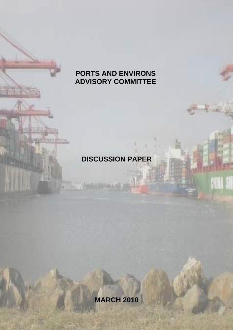
PORTS AND ENVIRONS ADVISORY COMMITTEE
DISCUSSION PAPER
MARCH 2010

PORTS AND ENVIRONS ADVISORY COMMITTEE DISCUSSION PAPER MARCH 2010
1
Contents
1. SUMMARY....................................................................................................................9
Part A - Background
2. BACKGROUND .........................................................................................................15 2.1 Terms of Reference ......................................................................................................15 2.2 Advisory Committee members .................................................................................16
3. CONSULTATION PROCESSES.............................................................................17 3.1 Approach ......................................................................................................................17 3.2 Issues raised and relationship to ToR.......................................................................17
4. LEGISLATIVE AND POLICY FRAMEWORK ....................................................20 4.1 Legislation ....................................................................................................................20
4.1.1 Planning and Environment Act, 1987 ...............................................................20 4.1.2 Port Services Act, 1995 .....................................................................................21 4.1.3 Environment Protection Act, 1970 ....................................................................23 4.1.4 Marine Act, 1988...............................................................................................24 4.1.5 Occupational Health and Safety Regulations 2007...........................................24
4.2 State Policies.................................................................................................................25 4.2.1 State Planning Policy Framework (SPPF) ........................................................25 4.2.2 Victorian Ports Strategic Framework 2004 ......................................................28 4.2.3 Port Futures – New Priorities and Directions for
Victoria’s Port System 2009 ............................................................................28 4.2.4 The Victorian Transport Plan 2008 ..................................................................31 4.2.5 Freight Futures: Victorian Freight Network Strategy 2008 .............................31 4.2.6 Victorian Coastal Strategy 2008 .......................................................................34
4.3 Local Planning Policies ...............................................................................................35 4.4 Port Land Use Strategies ............................................................................................40 4.5 Conclusion ....................................................................................................................42
Part B - Overview of Victoria's Ports
5. OVERVIEW OF VICTORIA’S PORTS ..................................................................44 5.1 Introduction .................................................................................................................44 5.2 Port of Melbourne .......................................................................................................45
5.2.1 Location and context .........................................................................................45 5.2.2 Governance .......................................................................................................47 5.2.3 Nature of trade throughput ................................................................................47 5.2.4 Current infrastructure ........................................................................................47 5.2.5 Road and transport issues..................................................................................47 5.2.6 Future development plan...................................................................................50 5.2.7 Key interface issues...........................................................................................54
5.3 Port of Hastings ...........................................................................................................55 5.3.1 Location and context .........................................................................................55 5.3.2 Governance arrangements .................................................................................57 5.3.3 Nature of trade throughput ................................................................................57 5.3.4 Current infrastructure ........................................................................................57 5.3.5 Road and transport issues..................................................................................58 5.3.6 Future development plan...................................................................................59 5.3.7 Key interface issues...........................................................................................60
5.4 Port of Geelong ............................................................................................................61

PORTS AND ENVIRONS ADVISORY COMMITTEE DISCUSSION PAPER MARCH 2010
2
5.4.1 Location and context .........................................................................................61 5.4.2 Governance .......................................................................................................63 5.4.3 Nature of trade throughput ................................................................................63 5.4.4 Current infrastructure ........................................................................................63 5.4.5 Road and transport issues..................................................................................64 5.4.6 Future development plans .................................................................................65 5.4.7 Geelong Port Structure Plan..............................................................................66 5.4.8 Key interface issues...........................................................................................67
5.5 Port of Portland ...........................................................................................................70 5.5.1 Location and context .........................................................................................70 5.5.2 Governance .......................................................................................................72 5.5.3 Nature of Trade throughput...............................................................................72 5.5.4 Current infrastructure ........................................................................................72 5.5.5 Road and transport issues..................................................................................73 5.5.6 Future development plans .................................................................................74 5.5.7 Key interface issues...........................................................................................75
5.6 Conclusion ....................................................................................................................76
Part C - Ports Environs
6. APPROACHES TO INTERFACE PLANNING IN THE PORT ENVIRONS .....................................................................................................78
6.1 Introduction .................................................................................................................78 6.2 Approaches to interface planning and management .............................................79
6.2.1 Creating buffer areas .........................................................................................79 6.2.2 Planning controls to create ‘reverse buffers’.....................................................80 6.2.3 Extend the range of sensitive uses.....................................................................81 6.2.4 Improve environmental and/or operational performance..................................82 6.2.5 Site design and layout .......................................................................................83 6.2.6 Relocation of nuisance or hazardous activities .................................................84 6.2.7 Legal agreements ..............................................................................................84 6.2.8 Notice of potential detriment.............................................................................85 6.2.9 Acquisition of land and change of use ..............................................................85 6.2.10 Memorandum of understanding ........................................................................86 6.2.11 Conclusions .......................................................................................................86
6.3 Planning tools under the VPPs ..................................................................................86 6.4 Stakeholders in interface planning ...........................................................................89 6.5 Advisory Committee discussion ...............................................................................92
7. IDENTIFYING THE PORT ENVIRONS FOR VICTORIA’S FOUR PORTS....................................................................................94
7.1 Introduction .................................................................................................................94 7.2 Nature of amenity and risks at the interfaces..........................................................96 7.3 Port of Melbourne .......................................................................................................97
7.3.1 Swanson Dock and Dynon precinct with South Kensington ............................97 7.3.2 Appleton Dock and Dynon Precinct with e-Gate..............................................99 7.3.3 Swanson Dock (Coode Island) with Yarraville precinct.................................101 7.3.4 Webb Dock with Garden City and The Strand................................................108 7.3.5 Station Pier with Beacon Cove and Port Melbourne.......................................114 7.3.6 Appleton Dock, Victoria Dock and South Wharf with Lorimer
Street and Fishermans Bend ..........................................................................116 7.3.7 Victoria Dock with Docklands........................................................................118 7.3.8 Holden Dock with Francis Street, Yarraville ..................................................121 7.3.9 Ann Street Pier, Gellibrand Pier and Breakwater Pier with the
former Port Phillip Woollen Mill site ............................................................125
PORTS AND ENVIRONS ADVISORY COMMITTEE DISCUSSION PAPER MARCH 2010
3
7.4 Conclusion ..................................................................................................................128 7.5 Port of Hastings .........................................................................................................128 7.6 Port of Geelong ..........................................................................................................130
7.6.1 North Shore residential area with Incitec Pivot and Midway..........................131 7.6.2 Norlane residential area with the industrial area east of Station Street ...........134 7.6.3 Former Ford site with ‘port area of interest’ land ...........................................137 7.6.4 Proposed Geelong marine industry project, Osborne Park,
Osborne House, and the Rippleside residential area with ‘port area of interest’ land..............................................................................139
7.6.5 Geelong Grammar School with ‘port area of interest land’ ............................142 7.7 Port of Portland .........................................................................................................146
Part D – Planning Framework
8. STATE PLANNING POLICY FRAMEWORK ...................................................150 8.1 Introduction ...............................................................................................................150 8.2 Advisory Committee discussion .............................................................................152 8.3 Key issues for consideration ....................................................................................155
9. LOCAL PLANNING POLICY FRAMEWORK...................................................156 9.1 Introduction ...............................................................................................................156 9.2 Local Planning Schemes ...........................................................................................156
9.2.1 Melbourne Planning Scheme ..........................................................................156 9.2.2 Port Phillip Planning Scheme..........................................................................157 9.2.3 Maribyrnong Planning Scheme.......................................................................159 9.2.4 Hobson’s Bay Planning Scheme .....................................................................160 9.2.5 Mornington Peninsula Planning Scheme ........................................................161 9.2.6 Greater Geelong Planning Scheme .................................................................163 9.2.7 Glenelg Planning Scheme ...............................................................................164 9.2.8 Status of Port Strategic Land Use Plans..........................................................165
10. EXISTING PLANNING CONTROLS APPLYING TO THE PORTS ............166 10.1 Introduction ...............................................................................................................166 10.2 Concerns with the current planning controls applying to the
Ports of Hastings, Geelong and Portland .............................................................166 10.3 Issues with the current planning controls applying to the waters
of the Ports of Geelong, Portland and Hastings ..................................................169 10.3.1 Background .....................................................................................................169 10.3.2 Advisory Committee discussion......................................................................170
11. PROPOSED PORT ZONE ......................................................................................172 11.1 Rationale for a new zone ..........................................................................................172 11.2 Proposed Port Zone ..................................................................................................173 11.3 Schedules to the Port Zone.......................................................................................180 11.4 Definition of Port .......................................................................................................180 11.5 Key issues for consideration ....................................................................................181
12. WHO SHOULD BE THE RESPONSIBLE AUTHORITY FOR THE PORTS OF HASTINGS, GEELONG AND PORTLAND?...............................182
12.1 Introduction ...............................................................................................................182 12.2 Issues ...........................................................................................................................182 12.3 Advisory Committee discussion .............................................................................183 12.4 Key issues for consideration ....................................................................................184
PORTS AND ENVIRONS ADVISORY COMMITTEE DISCUSSION PAPER MARCH 2010
4
13. INTEGRATING THE PORTS’ LAND USE STRATEGIES WITH THE PLANNING FRAMEWORK.........................................................................185
13.1 Introduction ...............................................................................................................185 13.2 Advisory Committee discussion .............................................................................185 13.3 Key issue for consideration ......................................................................................186
Part E - Conclusions
14. CONCLUSIONS......................................................................................................188
Appendices
APPENDIX A TERMS OF REFERENCE...............................................................189
APPENDIX B COMMITTEE MEMBERS BIOGRAPHIES ...............................194
APPENDIX C STAKEHOLDERS THAT MET WITH THE COMMITTEE.............................................................196
APPENDIX D STAKEHOLDERS THE COMMITTEE INVITED TO MAKE PRELIMINARY WRITTEN SUBMISSIONS ...............195
APPENDIX E STAKEHOLDERS WHO PROVIDED A PRELIMINARY WRITTEN SUBMISSION...............................197
APPENDIX F CURRENT PLANNING CONTROLS APPLYING TO THE PORTS.........................................................198
APPENDIX G DRAFT PORT ENVIRONS OVERLAY ......................................202
APPENDIX H DRAFT DESIGN AND DEVELOPMENT OVERLAY.............205
APPENDIX I DRAFT DEVELOPMENT PLAN SCHEDULE ..........................211
APPENDIX J DRAFT PARTICULAR PROVISION – PORT ENVIRONS PROTECTION ...........................................................210

PORTS AND ENVIRONS ADVISORY COMMITTEE DISCUSSION PAPER MARCH 2010
5
List of Figures
Figure 1 Port of Melbourne and surrounding areas ............................................... 46
Figure 2: Port of Hastings and surrounding areas .................................................. 56
Figure 3: Port of Geelong and surrounding areas ................................................... 62
Figure 4: Portland Port and surrounding areas ....................................................... 71
Figure 5 Swanston Dock and Dynon Project with South Kensington................... 98
Figure 6 Appleton Dock and Dynon Precinct with e-Gate.................................. 100
Figure 7 Swanson Dock (Coode Island) with Yarraville Precinct ...................... 102
Figure 8 Webb Dock with Garden City............................................................... 109
Figure 9 Webb Dock with The Strand (Williamstown) ...................................... 111
Figure 10 Station Pier with Beacon Cove ............................................................. 115
Figure 11 Appleton Dock, Victoria Dock, South Wharf with Lorimer Street and Fishermans Bend.................................................................. 117
Figure 12 Victoria Dock with Docklands.............................................................. 120
Figure 13 Holden Dock with Francis Street, Yarraville ........................................ 123
Figure 14 Ann Street Pier, Gellibrand Pier and Breakwater Pier with former Port Phillip Woollen Mill (Williamstown)................................ 126
Figure 15 North Shore with Port of Geelong Area of Interest Land ..................... 132
Figure 16 Norlane with Industrial Area to the West.............................................. 135
Figure 17 Former Ford site with Port of Geelong Area of Interest land........................................................................................................ 138
Figure 18 Marine Industry Project and Ripponlea with Port of Geelong Port Area of Interest land........................................................ 141
Figure 19 Shell Refinery with Geelong Grammar School .................................... 144
Figure 20 Port of Portland with South Portland .................................................... 147

PORTS AND ENVIRONS ADVISORY COMMITTEE DISCUSSION PAPER MARCH 2010
6
Abbreviations
CDZ: Comprehensive Development Zone
COGG: City of Greater Geelong
DIIRD: Department of Innovation, Industry and Regional Development
DOT: Department of Transport
DPCD: Department of Planning and Community Development
EMP: Environmental Management Plan
EPA: Environment Protection Authority
HPFV: High Productivity Freight Vehicles
IMT: Inter-modal terminal
LPPF: Local Planning Policy Framework
MAEO: Melbourne Airport Environs Overlay
MHF: Major Hazard Facility
MoU: Memorandum of Understanding
MSS: Municipal Strategic Statement
NSW: New South Wales
PDS: Port Development Strategy
PEPF: Port Environs Planning Framework
PLUS: Port Land Use Strategy
PLUTS: Port of Hastings Land Use and Transport Strategy
PoMC: Port of Melbourne Corporation
PCRZ: Public Conservation and Resource Zone
PSA: Port Services Act, 1995
PSEMP: Port Safety Environmental Management Plan
SPPF: State Planning Policy Framework
SUZ: Special Use Zone
TEU: Twenty-foot equivalent unit
ToR: Terms of Reference
VCS: Victorian Coastal Strategy
VFLC: Victorian Freight and Logistics Council

PORTS AND ENVIRONS ADVISORY COMMITTEE DISCUSSION PAPER MARCH 2010
7
VPPs: Victoria Planning Provisions
VPSF: Victorian Ports Strategic Framework
VTS: Victorian Transport Strategy

PORTS AND ENVIRONS ADVISORY COMMITTEE DISCUSSION PAPER MARCH 2010
8
Submissions
The main purpose of this Discussion Paper is to invite written submissions
on the issues identified by the Advisory Committee following its
consultations with key stakeholders.
To assist submitters respond to the issues, the Committee has identified Key
issues for consideration in most sections of this report in a question format.
This does not preclude stakeholders raising other issues relevant to the
Committee’s Terms of Reference (ToR).
Submissions are invited in writing by close of business Friday, 25 June 2010.
Submissions must be sent to:
Chair
Ports and Environs Advisory Committee
Planning Panels Victoria
GPO Box 2392
Melbourne 3001 Vic
Alternatively, submissions can be faxed on 9637 9700 or emailed to
The Advisory Committee proposes to commence public hearings after
receiving submissions. Further advice will be provided as to when the
hearings will be held. The public hearings are intended to provide an
opportunity for submitters to clarify information or views as presented by
them in their written submissions.
PORTS AND ENVIRONS ADVISORY COMMITTEE DISCUSSION PAPER MARCH 2010
9
1. Summary
The Ports and Environs Advisory Committee was appointed by the Minister
for Planning in September 2009 to, amongst other matters:
determine whether the existing and proposed planning controls
applying to the Ports of Hastings, Geelong and Portland are adequate
to ensure the protection of the ports from the encroachment of sensitive
uses;
review the issues raised in the draft Port of Melbourne Port Environs
Planning Framework (PEPF) and provide recommendations on how the
framework can be implemented; and
advise on appropriate and streamlined planning controls that could
apply to the use and development of land and waters to the Ports of
Hastings, Geelong and Portland.
The need for the review stems from a number of significant issues affecting
Victoria’s four commercial trading ports at Melbourne, Hastings, Geelong
and Portland, including:
significant increased activity at the ports as a result of increasing
international trade and forecasts for continued growth in trade;
concern from port managers about the encroachment of sensitive uses
near the ports that may impact on the ability of the ports to
accommodate increased growth;
expectations by local communities that the ports operate to high
standards of environmental performance; and
concerns by port managers about the effectiveness of planning controls
to provide an efficient and streamlined assessment process for
development projects identified in the ports’ land use strategies.
The Advisory Committee comprises Mark Marsden (Chair), Des Grogan,
Helen Weston and David Whitney.
The Committee is required to produce a Discussion Paper, invite
submissions on the Discussion Paper and prepare a final report.
In preparing the Discussion Paper, the Committee has held discussions with
the port managers, Council officers, relevant government departments and
agencies and some community groups. The Committee also invited these
stakeholders to make preliminary written submissions.
PORTS AND ENVIRONS ADVISORY COMMITTEE DISCUSSION PAPER MARCH 2010
10
As well as meeting key stakeholders, the Committee inspected the four ports
and their surrounds.
This Discussion Paper is divided into the following parts:
Part A – Background (Chapters 2, 3 and 4)
This part includes background on the role of the Advisory Committee, the
consultation processes adopted by the Committee and the legislative and
policy framework relevant to ports. The chapter on consultation includes a
discussion on the scope of the Committee’s task.
Part B – Overview of Victoria’s ports (Chapter 5)
This part provides a summary of Victoria’s four ports in terms of location
and context, governance, nature of trade throughput, current infrastructure,
road and transport issues, key interface issues and future development plans.
This information has been summarised from a number of State Government
policies relating to ports and freight and also from the land use strategies
that have been prepared for each of the ports by the port managers pursuant
to the Port Services Act, 1995 (PSA).
The ports’ land use strategies provide a useful framework for each of the
ports to identify and plan for their future requirements in terms of land
needs, infrastructure requirements and addressing existing and potential
amenity impacts beyond the ports’ boundaries.
With forecasts of significantly increased international trade and increased
activity at each of the ports, it will be even more important that the ports’
land use strategies are further developed and integrated into the statutory
planning framework to ensure a transparent and efficient decision‐making
framework.
Part C – Port Environs (Chapters 6 and 7)
The first chapter in this part identifies a range of approaches to interface
planning that have been applied in various situations to address concerns
that can arise when incompatible land uses are neighbours. While ten
different approaches to interface planning have been identified, the
Committee believes that the environmental performance of the ports and
port users should be the starting point to manage the interface between the
ports and surrounding areas. However, the Committee has a limited role to
play in relation to the ports’ compliance with relevant environmental
policies, guidelines and standards. This matter is beyond the Committee’s

PORTS AND ENVIRONS ADVISORY COMMITTEE DISCUSSION PAPER MARCH 2010
11
ToR which are restricted to issues associated with the statutory planning
framework.
This chapter also includes a matrix which has been developed to identify the
relevant agency that would have responsibility for the implementation of the
interface treatment and opportunities for stakeholder involvement.
With respect to successfully planning for the reasonable co‐existence of the
ports and surrounding areas, the Committee considers it is essential that the
planning system recognises that the four commercial trading ports are able to
operate 24 hours a day, seven days a week. As a result, port activities and
hours of operations, ports can generate off‐site amenity impacts beyond their
boundaries which have the potential to cause nuisance to uses considered
‘sensitive’ such as residential development or certain community facilities.
It is also important that the planning system recognises that there are areas
near these long‐established ports which are now sought after residential
areas because of their coastal location, and, in the case of the ports of
Melbourne, Geelong and Portland, their inner urban setting. Further,
planning policy at both the State and local levels which actively promotes
intensification of established urban areas also contributes to the demand for
residential development close to the ports.
In the second chapter in this part, the Committee provides a detailed
examination of the interface areas between each of the ports and surrounding
areas that potentially contain sensitive uses having regard to:
the nature of existing uses and developments within each of the ports;
the future plans for each of port as identified in its land use strategy;
the nature of existing and future uses and developments (if known)
surrounding each port; and
relevant planning objectives and strategies in the applicable planning
schemes.
From these investigations, the Committee is seeking comment as to whether:
the interface area beyond the specific port boundary should be
identified as a port environs area that requires some form of interface
treatment;
the identified port environs area should be subject to a planning
mechanism under the statutory planning framework, such as an
alternative zone to restrict the type of uses or an overlay to control the
nature of development;
PORTS AND ENVIRONS ADVISORY COMMITTEE DISCUSSION PAPER MARCH 2010
12
the port manager should be a prescribed authority under Clause 66.10
of the VPPs for notice and/or referral of applications in the port
environs; or
some other collaborative approach is appropriate between the port
manager, relevant authority and other stakeholders.
The Committee has provided a detailed analysis to determine the key
interface areas for each of the ports in preference to a more arbitrary
approach that would simply delineate a certain distance from the port
boundaries to be included in the port environs. In the Committee’s view, an
arbitrary approach may not be justified given the significant variation in the
nature of activities occurring within different parts of each of the ports and
the diversity of surrounding land uses and development. In other words, a
‘horses for courses’ approach is adopted. However, the Committee is
seeking responses from submitters on whether a more arbitrary approach
may be justified for some or all ports.
Part D – Planning Framework (Chapters 8, 9, 10, 11, 12 and 13)
The first two chapters of this part provide an overview of the clauses
pertaining to ports found in the State Planning Policy Framework (SPPF) and
in the local policies of the relevant municipal planning schemes relevant to
each of Victoria’s four commercial trading ports and their environs.
Given the strategic importance of the ports, the Committee considers that the
SPPF could be enhanced by acknowledging the importance of ensuring the
future growth and development of the ports as well as recognising the need
for a two‐way consideration of interface issues between the ports and their
environs. In addition, the Committee considers that State Government
policies relating to ports and individual port land use strategies should all be
included in the planning scheme as reference documents.
An overview of the relevant municipal planning scheme local policies
relating to ports is then provided, including consideration of the
recommendations of the Port Environs Planning Framework (PEPF) prepared
for the Port of Melbourne.
In broad terms, the Committee considers that most of the local planning
schemes adequately recognise the economic significance of the ports.
However, the Committee provides suggestions to improve some local
policies particularly in relation to the need for responsible authorities to
consider the interface areas between ports and their environs.
Following consideration of State and local policies, the Committee provides
an analysis of the existing planning controls applying to the ports of
PORTS AND ENVIRONS ADVISORY COMMITTEE DISCUSSION PAPER MARCH 2010
13
Hastings, Geelong and Portland. A number of concerns are identified about
the inconsistency between the zoning provisions that apply to these three
ports and the opportunities to provide more transparent and streamlined
planning controls. In addition, the Committee considers there needs to be
stronger integration between local policy and planning controls relating to
ports.
To address the deficiencies of the existing planning controls, the Committee
suggests a new purpose‐specific Port Zone that should apply to all land
within the port boundaries or port area of interest as identified in the
respective port land use strategies. A draft of the Port Zone has been
prepared for consideration by submitters.
While the Committee’s ToR do not include a review of the planning controls
applying to the Port of Melbourne under the Port of Melbourne Planning
Scheme, it considers that the Port Zone could also apply to this port.
In addition, the Advisory Committee has developed a definition of Port for
inclusion in Clause 74 of the VPPs.
During its consultations, the Committee heard submissions as to whether or
not the State Government should be the planning and responsible authority
for the ports of Hastings, Geelong and Portland1. Each port land use strategy
contains recommendations that the State Government should be the
planning and responsible authority for the ports. In the Committee’s view,
the more important issue is not who the planning and responsible authority
should be, but whether a more effective and efficient planning framework
will achieve State and local planning objectives for the ports.
Finally, the Committee provides some analysis on the potential to improve
integration between the ports’ land use strategies and the statutory planning
framework. In the Committee’s view, there is potential to review the manner
in which ports’ land use strategies are prepared so that in the future they
could be considered for inclusion as Incorporated Plans or Development
Plans in the planning schemes.
Part E Conclusions (Chapter 14)
In this part, the Committee identifies key conclusions relating to its ToR as a
result of the first stage of the consultative process.
1 The Minister for Planning is the responsible authority for the Port of Melbourne Planning Scheme

PORTS AND ENVIRONS ADVISORY COMMITTEE DISCUSSION PAPER MARCH 2010
14
Part A – Background
PORTS AND ENVIRONS ADVISORY COMMITTEE DISCUSSION PAPER MARCH 2010
15
2. Background
2.1 Terms of Reference
The tasks of the Advisory Committee are:
Port Environs Matters
· Determine whether the existing and proposed planning scheme
controls applying to the environs of the Ports of Geelong, Hastings
and Portland are adequate to ensure the protection of the ports
against the encroachment of sensitive uses.
· Review the issues raised in the draft Port of Melbourne Port
Environs Planning Framework (Port of Melbourne Corporation) and
provide recommendations on how the framework can be
implemented, as appropriate.
· Make recommendations on appropriate boundaries for the land that
would constitute ‘port environs’ for all of the four commercial ports.
· Make recommendations that would protect the ports from
encroachment of sensitive uses through the use of appropriate
planning policy and applications of the Victoria Planning
Provisions.
· Respond to any other matters that the Advisory Committee considers
relevant to planning and development controls of the four
commercial ports so that they remain competitive and sustainable.
Port Planning Controls
· Advise on appropriate and streamlined planning controls that could
apply to the use and development of land and where relevant, the
waters of the Ports of Geelong, Portland and Hastings. This should
have regard to the current model used in the Port of Melbourne
Planning Scheme for which the Minister for Planning is Responsible
Authority. (The Advisory Committee is not to consider or make
recommendations that separate planning schemes be developed for
the ports of Geelong, Hastings and Portland or review the planning
controls applying to the Port of Melbourne).
· Draft appropriate planning scheme provisions that could apply to the
Ports of Geelong, Portland and Hastings.

PORTS AND ENVIRONS ADVISORY COMMITTEE DISCUSSION PAPER MARCH 2010
16
The ToR are included in Appendix A.
2.2 Advisory Committee members
The Advisory Committee was appointed by the Minister for Planning on 18
September 2009 and comprises:
Mark Marsden (Chair);
Des Grogan;
Helen Weston; and
David Whitney.
Biographies of the Advisory Committee members are attached in Appendix
B.
PORTS AND ENVIRONS ADVISORY COMMITTEE DISCUSSION PAPER MARCH 2010
17
3. Consultation processes
3.1 Approach
In accordance with the ToR, the Advisory Committee is pursuing a two stage
consultative process:
Stage 1 – Preparation of the Discussion Paper. During this stage, the
Committee conducted discussions with port managers, Council officers,
government departments and agencies and some community groups, to
assist it gain an understanding of the major issues concerning the ports and
the port environs.2.
From these lists, the Committee identified key stakeholders it should meet
with (Appendix C) and key stakeholders that should be invited to make a
preliminary submission (Appendix D). A list of stakeholders who provided
a preliminary written submission is found in Appendix E.
Stage 2 – Development of Final report. During this stage, the Advisory
Committee will conduct formal public hearings on submissions in response
to the Discussion Paper. Its final report will be prepared after the public
hearings and submitted to the Minister for Planning.
As well as meeting key stakeholders, the Committee has conducted
inspections of the four ports and their surrounds.
3.2 Issues raised and relationship to ToR
In responding to the ToR, the Committee has been mindful that the output of
its inquiry is to recommend to the Minister for Planning a policy and
statutory planning framework that:
ensures that appropriate recognition is given in planning schemes to
the strategic importance of Victoria’s major commercial trading ports to
the economy of the State and of the regions in which they are located;
facilitates the future development of the ports in an economically and
environmentally sustainable manner;
enables land use and development in both the ports and their environs
to co‐exist safely and with reasonable/acceptable levels of amenity;
2 The Committee asked both the port managers and Council officers for a list of stakeholders the
Committee should contact.
PORTS AND ENVIRONS ADVISORY COMMITTEE DISCUSSION PAPER MARCH 2010
18
restricts the potential for sensitive uses which might compromise
existing and planned port use and development to encroach into port
environs; and
facilitates approvals for port use and development in timely and
efficient manner.
In preparing this Paper, some stakeholders have raised issues related to the
ports which extend beyond statutory planning processes and the
Committee’s ToR. Many of these issues, while of interest and importance,
are beyond the scope of this inquiry. Nevertheless, in the Committee’s
opinion, they are worthy of mention as matters to which the Government
could direct its attention in appropriate forums in the future.
These matters include, but are not confined to, the following:
The role of Victoria’s four commercial trading ports in terms of the
nature of their respective trade throughputs and whether individual
ports should be accepting or refusing certain throughputs to address
concerns about amenity and/or community safety and health at the
various ports. For example, the Committee considers it is beyond its
ToR to make recommendations for the Port of Hastings to accept
increased throughput of certain goods in order to address amenity or
risk concerns within the Port of Melbourne.
The need to identify strategic transport linkages between the ports and
proposed new ‘inland ports’ or freight and logistics centres as well as
the need for appropriate planning measures to protect these transport
corridors and inter‐modal facilities.
The adverse amenity impacts of port‐related traffic and transport, for
example, road traffic noise. While such impacts could be more
significant for many local residents than other amenity impacts from
port or port‐related activities, road and transport matters are regulated
by State policies and controls other than the statutory planning
framework. 3 However, it may be possible in some situations where an
overlay could be imposed along a transport corridor to mitigate the
impacts of traffic noise. For example, there is a Design and
Development Overlay in the Hume Planning Scheme that applies
adjacent to parts of the Hume Freeway (Craigieburn Bypass) that
requires development to be designed to minimise the impact of traffic
noise on noise sensitive activities.4
The Committee’s role in assessing individual development proposals
within ports. For example, the Committee has received letters from
3 For example, VicRoads Traffic Noise Reduction Policy 2005. 4 Clause 43.02 of Hume Planning Scheme.
PORTS AND ENVIRONS ADVISORY COMMITTEE DISCUSSION PAPER MARCH 2010
19
some residents in The Strand in Williamstown who are concerned that
the Committee is not able to determine the port environs without
considering the potential impacts of the proposed Webb Dock
development within the Port of Melbourne. In the Committee’s view,
the ToR require consideration of potential interface issues having
regard to the future development of the ports as identified in the ports’
strategic land use plans. However, this does not require or enable the
Committee to assess individual future development proposals.
Water‐based conflicts between shipping movements and recreational
boating and fishing activities. In the Committee’s view, these issues are
addressed through relevant marine safety regulations, not the statutory
planning framework.
In addition, some stakeholders addressed the Committee on health and
safety risks associated with the storage, handling and transport of hazardous
materials such as butadiene. While these concerns are understood, it is not
the role of this Committee to assess the performance of industries that store,
handle and transport major hazards, nor is it the role of the Committee to
assess the performance of the Environment Protection Authority (EPA) or
WorkSafe Victoria in monitoring these industries. Furthermore, it is not the
role of the Committee to comment on the appropriateness of EPA threshold
distances or WorkSafe safety guidelines.
However, the Committee does consider health and safety issues in terms of
the statutory planning framework which incorporates as guidelines the EPA
threshold distances between uses with potential amenity and risk and
sensitive uses.5 Accordingly, the Committee has considered the EPA
threshold distances in determining the port environs boundaries.
It is not the Committee’s intention to deal further with these matters and
trusts that the responses to this Discussion Paper will be confined to
addressing the matters set out in the Committee’s ToR.
5 Refer to Clause 52.10 of the Victoria Planning Provisions (VPPs)
PORTS AND ENVIRONS ADVISORY COMMITTEE DISCUSSION PAPER MARCH 2010
20
4. Legislative and Policy framework
In this section of the report, the legislation and policies relevant to the
Advisory Committee’s tasks are identified and summarised.
4.1 Legislation
4.1.1 Planning and Environment Act, 1987
The Planning and Environment Act, 1987 provides for the land use planning
framework in Victoria. The objectives of planning in Victoria are to:
(a) to provide for the fair, orderly, economic and sustainable use, and
development of land;
(b) to provide for the protection of natural and man‐made resources and
the maintenance of ecological processes and genetic diversity;
(c to secure a pleasant, efficient and safe working, living and
recreational environment for all Victorians and visitors to Victoria;
(d) to conserve and enhance those buildings, areas or other places which
are of scientific, aesthetic, architectural or historical interest, or
otherwise of special cultural value;
(e) to protect public utilities and other assets and enable the orderly
provision and co‐ordination of public utilities and other facilities for
the benefit of the community;
(f) to facilitate development in accordance with the objectives set out in
paragraphs (a), (b), (c), (d) and (e);
(g) to balance the present and future interests of all Victorians.
The objectives of the planning framework established by this Act relevant to
this Inquiry are:
(a) to ensure sound, strategic planning and co‐ordinated action at State,
regional and municipal levels;
(b) to establish a system of planning schemes based on municipal
districts to be the principal way of setting out objectives, policies and
controls for the use, development and protection of land;
(c) to enable land use and development planning and policy to be easily
integrated with environmental, social, economic, conservation and
PORTS AND ENVIRONS ADVISORY COMMITTEE DISCUSSION PAPER MARCH 2010
21
resource management policies at State, regional and municipal
levels;
(d) to ensure that the effects on the environment are considered and
provide for explicit consideration of social and economic effects when
decisions are made about the use and development of land;
(e) to facilitate development which achieves the objectives of planning in
Victoria and planning objectives set up in planning schemes;
(f) ….
(g) to encourage the achievement of planning objectives through positive
actions by responsible authorities and planning authorities;
(h) to establish a clear procedure for amending planning schemes, with
appropriate public participation in decision making;
(i) to ensure that those affected by proposals for the use, development or
protection of land or changes in planning policy or requirements
receive appropriate notice;
(j) ….
(k) ….
(l) ….
4.1.2 Port Services Act, 1995
Port Development Strategies
Part 6B of the Port Services Act, 1995 (PSA) requires the port authorities to
prepare a Port Development Strategy (PDS) every four years. The PDS is to
include:
(a) projections of trade through the commercial trading port;
(b) current and projected land use requirements, including transitional
land uses designed to protect the port from constraints on efficient
operations and mitigate adverse impacts of port operations on
adjacent uses;
(c) current and projected infrastructure requirements for land and
water in the commercial trading port;
(d) current and projected transport infrastructure requirements for land
and water in the commercial trading port;
(e) any other matters specified in any guidelines.
In addition, a PDS must be prepared and submitted to the Minister in
accordance with guidelines.
PORTS AND ENVIRONS ADVISORY COMMITTEE DISCUSSION PAPER MARCH 2010
22
Section 91M states that the Minister may issue guidelines in relation to the
preparation of a PDS addressing:
(a) the form;
(b) the content;
(c) the method and process for preparation;
(d) processes to enable tenants, licensees and service providers in the
port to be involved in the preparation;
(e) processes for consultation with people affected;
(f) publication and availability.
Port of Melbourne
The PSA provides for the establishment and regulation of the Port of
Melbourne Corporation (PoMC) and sets out its powers. Section 12 provides
that the objectives of the PoMC are to:
(a) manage and develop the Port of Melbourne in an economically,
socially and environmentally sustainable manner;
(b) to ensure that essential port services at the Port of Melbourne are
available and cost effective;
(c) to ensure, in cooperation with other relevant responsible bodies, that
the Port of Melbourne is effectively integrated with other systems of
infrastructure in the State;
(d) to facilitate in cooperation with other responsible bodies, the
sustainable growth of trade through its Port of Melbourne; and
(e) to establish and manage channels in Port of Melbourne waters for
use on a fair and reasonable basis.
Section 13 of the PSA provides that the functions of PoMC are as follows:
(a) to plan for the development and operation of the Port of Melbourne;
(b) to provide land, waters and infrastructure necessary for the
development and operation of the Port of Melbourne;
(c) to develop or enable and control the development by others of the
whole or any part of the Port of Melbourne;
(d) to manage or enable and control the management by others of, the
whole or any part of the Port of Melbourne;
(e) to provide or enable and control the provision by others of, services
for the operation of the port of Melbourne;
(f) to promote and market the port of Melbourne;
PORTS AND ENVIRONS ADVISORY COMMITTEE DISCUSSION PAPER MARCH 2010
23
(g) to facilitate the integration of infrastructure and logistics systems in
the port of Melbourne with relevant systems outside the Port;
(ga) to manage and in accordance with standards developed by the
Director of Marine Safety, to dredge and maintain channels in port
of Melbourne waters;
(gb) to provide and maintain in accordance with the standards developed
by the Director of Marine Safety, navigation aids in connection with
navigation in port of Melbourne waters;
(gc) generally, to direct and control in accordance with the Marine Act
1988, the movement of vessels in port of Melbourne waters;
(h) any other functions that are conferred on the Corporation by or
under this or any Act.
In addition, the PoMC must carry out its functions in a manner that is safe
and secure, effective and efficient, commercially sound and that has regard
for persons living or working in the immediate neighbourhood of the Port of
Melbourne.
Under the PSA ‘Port of Melbourne land’ includes land that is in the
municipal district of the Cities of Melbourne, Maribyrnong, Hobsons Bay
and Port Phillip, or any land in the Bay adjoining one or more of those
municipal districts.
Port of Hastings Corporation
The PSA also established the Port of Hastings Corporation. The functions of
the Corporation are identical in nature to those outlined above for the PoMC.
4.1.3 Environment Protection Act, 1970
The Environment Protection Act, 1970 established the Environment Protection
Authority (EPA), outlines its powers, duties and responsibilities and makes
provision for the prevention of pollution and the protection of the
environment.
In terms of Victoria’s ports, the EPA is responsible for the licensing of certain
premises that are responsible for the discharge, emission or deposit of waste
to the environment. There are a number of premises operating within
Victoria’s ports that require EPA licences and approvals.
PORTS AND ENVIRONS ADVISORY COMMITTEE DISCUSSION PAPER MARCH 2010
24
4.1.4 Marine Act, 1988
The purposes of the Marine Act, 1988 are:
to re‐enact with amendments the law relating to the registration of
vessels and the pollution of State waters;
to implement certain international conventions; and
to provide for the efficient and safe operation of vessels on State waters.
4.1.5 Occupational Health and Safety Regulations 2007
The Occupational Health and Safety Regulations 2007 further the objectives
of the Occupation Health and Safety Act 2004 by:
(i) providing for health and safety in relation to workplaces and
hazards, activities and things at workplaces; and
(ii) providing for the safe operation of major hazard facilities and mines
in order to reduce the likelihood of a serious incident occurring; and
(iii) providing for the registration of certain people engaged in
construction work at workplaces; and
(iv) providing for the licensing of certain people engaged in high risk
work at workplaces; and
(v) providing procedures for the resolution of health and safety issues
at workplaces; and
(vi) specifying the information to be included in entry permits issued
under Part 8 of the Act; and
(vii) providing for other matters that are required or permitted by the
Act or that are necessary to give effect to the Act.
The Regulations also seek to further the objectives of the Dangerous Goods Act
1985 by providing for the protection of property from damage from the use
of dangerous goods at major hazard facilities.

PORTS AND ENVIRONS ADVISORY COMMITTEE DISCUSSION PAPER MARCH 2010
25
4.2 State Policies
4.2.1 State Planning Policy Framework (SPPF)
The SPPF policies apply to all land in Victoria and must be taken into
account when preparing amendments or making decisions under a planning
scheme. Those policies that are most relevant to ports include the following:
Clause 11 – Introduction Goals and Principles – Clause 11.03 ‐ Principles of Land
Use and Development Planning identifies the following seven general
principles for planning in Victoria; Settlement; Environment; Management of
Resources; Infrastructure; Economic well‐being; Social needs and Regional
co‐operation. In short, planning must take account of these matters
including their underlying policies and strategies, to ensure the best overall
outcomes for current and future generations. This inevitably involves
judgement on balances between individual principles. It requires that
Victoria’s planning objectives are fostered through appropriate land use and
development planning which integrates relevant environmental, social and
economic factors in the interests of net community benefit and sustainable
development.
Clause 11.03‐1 – Settlement requires planning to anticipate and respond to the
needs of existing and future communities through provision of zoned and
serviced land for housing, employment, recreation and open space,
commercial and community facilities and infrastructure. This is relevant in
the context of ensuring environment protection and community health and
safety in relation to coastal hazards arising from the effects of climate change.
11.03‐2 – Environment relates to obligations under national and state
environment policies and strategies. The policy requires planning to:
· Adopt a best practice environmental management and risk
management approach which aims to avoid or minimise
environmental degradation and hazards.
· Prevent environmental problems created by siting incompatible land
uses close together.
· Help to protect the health of ecological systems and the biodiversity
they support (including ecosystems, habitats, species and genetic
diversity).
· Protect areas and sites with significant historic, architectural,
aesthetic, scientific and cultural values.
PORTS AND ENVIRONS ADVISORY COMMITTEE DISCUSSION PAPER MARCH 2010
26
11.03‐3 ‐ Management of resources requires planning to assist in the
conservation of natural resources, to minimise hazards such as flooding and
to minimise impacts on estuarine, coastal and marine environments. It also
recognises the Department of Sustainability and Environment and
Committees of Management as managers of Crown land when making
decisions affecting Crown land.
11.03‐5 ‐ Economic well‐being is relevant because it seeks to foster the well
being of communities and support economic growth through the provision
of land and resolving land use conflicts.
11.03‐6 ‐ Social needs seeks to provide a safe physical and social environment
for residents, through the appropriate location of uses and developments.
Clause 12 Metropolitan Development ‐ This clause provides objectives and
strategies for Metropolitan Melbourne.
Under Clause 12.05 – A great place to be, Clause 12.05‐2 – Strategies and under
Coastal Areas seeks to improve the environmental health of the bays through
reducing the pressures of urban growth through growth area planning,
managing waterway and stormwater quality and protecting coastal and
foreshore environments, providing public access and recreation facilities
around the Bays. Importantly, the policy also requires coastal planning and management to be consistent with the Victorian Coastal Strategy and to
manage privately owned foreshore consistently with the adjoining public land.
Under Clause 12.07 – A greener city, Clause 21.07‐2 – Strategies under Native
habitat and biodiversity seeks to protect flora and fauna habitat and landscapes
such as the coastal areas, Western Port and the Mornington Peninsula.
Clause 14 – Settlement under Clause 14.01‐2 – General Implementation
recognises the need to plan to accommodate projected population growth
taking account of land capability and natural hazards, environmental quality
and the costs of providing infrastructure. The policy also seeks to protect
environmentally sensitive areas such as Western Port and Port Phillip Bays
and their foreshores, the Gippsland Lakes and its foreshore and coastal areas
and their foreshores from development which would diminish their
environmental conservation or recreation values.
Clause 15 – Environment under Clause 15.01 – Protection of catchments,
waterways and groundwater seeks to:
To assist the protection and, where possible, restoration of catchments,
waterways, water bodies, groundwater, and the marine environment.
PORTS AND ENVIRONS ADVISORY COMMITTEE DISCUSSION PAPER MARCH 2010
27
Clause 15.08 – Coastal Areas is the key policy relating to coastal climate
change effects. It was amended under VC52 on 18 December 2008 following
the release of the 2008 VCS. Under Clause 15.08‐1 the objectives are:
· To protect and enhance the natural ecosystems and landscapes of the
coastal estuarine and marine environment.
· To ensure sustainable use of natural coastal resources.
· To achieve development that provides an environmental, social and
economic balance.
· To recognise and enhance the community’s value of the coast.
· To plan for and manage the potential coastal impacts of climate
change.
Clause 18.05 – Ports has the objective of:
· recognising the importance to Victoria of economically sustainable
major ports(Melbourne, Geelong, Portland Hastings) by planning
for appropriate access, terminal areas and depot areas”; and
· planning the land resources adjacent to ports to “facilitate the
efficient operation of the port and port‐related uses and minimise
adverse impacts on surrounding urban development and
environment”.
Clause 18.05‐2 states:
The land resources adjacent to ports should be protected to preserve their
value for uses which depend upon or gain significant economic advantage
from proximity to the ports’ particular shipping operations.
Port and industrial development should be physically separated from
sensitive urban development by the establishment of appropriate buffers
which reduce the impact of vibration, intrusive lighting, noise and air
emissions from port activities.
Planning for the use of land adjacent to ports should aim to achieve and
maintain a high standard of environmental quality, be integrated with
policies for the protection of the environment generally and of marine
environments in particular and take into account planning for adjacent
areas and the relevant catchment.

PORTS AND ENVIRONS ADVISORY COMMITTEE DISCUSSION PAPER MARCH 2010
28
4.2.2 Victorian Ports Strategic Framework 2004
The Victorian Ports Strategic Framework (VPSF) 2004 is an older strategy that
has been superseded by Port Futures (2009). The policy proposed that the
four commercial trading ports should focus on reinforcing and developing
their existing core trade roles. In the case of the ports of Portland, Geelong
and Hastings, these are primarily the handling of dry and liquid bulk
cargoes and break bulk cargoes related largely to steel and aluminium
products. In the case of the Port of Melbourne, the emphasis was on
developing its specialised capacity to handle containerised cargo,
acknowledging that it will also continue to play an important role in relation
to bulk and break bulk commodities.
The VPSF nominated Hastings as Victoria’s second largest container port, to
act as an overflow for this trade once Melbourne reaches its full capacity.
In relation to competition between Victoria’s ports, the policy generally
encouraged this for the bulk and break bulk trades but not for international
containers which were earmarked exclusively for Melbourne until it reaches
capacity around 2035 (based on current trade forecasts and anticipated
productivity improvements in stevedoring terminals) and then for Hastings.
The VPSF did not make any explicit statement in relation to competition for
service provision within the ports, particularly for container stevedoring.
However the policy implicitly favours an approach of deferring a process
which might attract a new third entrant until around 2017. It anticipated
that, by then, all potential capacity available to the two incumbent stevedores
at Swanson Dock would be exhausted and it would be necessary to establish
a new terminal at Webb Dock. However, the VPSF noted the need for
flexibility, stating that this should be revalidated periodically as commercial and
other changes occur.
4.2.3 Port Futures – New Priorities and Directions for Victoria’s Port System 2009
Port Futures (2009) updates the Victorian Port Strategic Framework 2004 and
introduces improved policy and strategy settings to maximise the
contribution of Victoriaʹs ports to state and national economic prosperity.
The goal of Port Futures is to introduce improved policy and strategy settings to
ensure that the contribution of Victoria’s ports to state and national economic
prosperity and sustainability is maintained and maximised.
PORTS AND ENVIRONS ADVISORY COMMITTEE DISCUSSION PAPER MARCH 2010
29
Port Futures outlines the following key priorities and actions:
Re‐affirm port trade roles and development
Under Port Futures, the four commercial trading ports will develop their
existing core trade roles:
The Port of Melbourne will continue to develop its specialised capacity
to handle containerised cargo;
The ports of Portland, Geelong and Hastings will continue to focus on
the bulk trades and break bulk cargoes related largely to steel and
aluminium production; and
The role of the Port of Hastings to act as an overflow container port for
the Port of Melbourne is also reaffirmed, with further assessment of
timing of this development to be undertaken.
Accelerate port development at Melbourne and Hastings
Port Futures proposes to meet strong projected medium to long term growth
in freight volumes by accelerating the development of an initial module of new
stevedoring capacity at Webb Dock and progressing the development of the Port of
Hastings. Specifically, the Government will:
Consider bringing forward an initial module of terminal capacity at
Webb Dock (up to one million Twenty Foot Equivalent Units (TEUs);
Maintain the existing planning reservation for the Webb Dock Rail Link
for future consideration;
Progress planning to increase capacity of the existing East and West
Swanson Dock container terminals and wharves; and
Progress planning and environmental investigations for the staged
expansion of the Port of Hastings.
Enhance port access, efficiency, productivity and investment
Port Futures details a range of strategies to improve port access, efficiency,
productivity and investment, including:
Deepening the Port of Melbourne shipping channels to allow access for
14 metre draft vessels at all tides;
Progressing development of a staged, long term ‘channel improvement
program’ for the Port of Geelong;
Implementing the initiatives from the Truck Optimisation Plan (2009)
prepared by the Victorian Freight Logistics Council;
Designing and implementing a Road Freight Access Charge for trucks
accessing the major terminals at Port of Melbourne;
PORTS AND ENVIRONS ADVISORY COMMITTEE DISCUSSION PAPER MARCH 2010
30
Further developing the Metropolitan Freight Terminal Network; and
Exploring the scope to secure ongoing port productivity improvements
through direct negotiations with port service providers.
Secure the provision of essential port services
Port Futures identifies towage and ship lift facilities in the Port of Melbourne
as essential port services.
Improve port governance arrangements
The policy confirms the Government’s intention to integrate the governance
and management of the ports of Hastings and Melbourne and to review the
role of the PoMC ‘beyond the port gate’ in order to maximise the contribution of
Victorian ports to the efficiency of the broader freight and logistics network.
Introduce measures to improve planning and buffer protections for ports
and local communities
Port Futures identifies the critical need to facilitate port planning and protect
ports from encroachment by surrounding sensitive uses as well as protecting
neighbouring communities from the impacts of port operations. The policy
proposes a range of initiatives be examined to streamline and strengthen
planning processes and protections including:
Formally recognising port strategic plans and strengthening policies to
separate port activities from residential and other sensitive uses in the
SPPF;
Establishing the Minister for Planning as the responsible authority for
the land controlled by the regional ports, as is already the case for the
Port of Melbourne;
Ensuring that the interests of the ports are explicitly considered in the
evaluation of planning scheme amendments involving policy and
zoning changes in the environs surrounding the ports controlled land;
and
Considering the reinstatement of industrial zones where appropriate
and new planning controls to establish two‐way buffer protections for
ports.
Improve Port Safety, Security and Environmental Performance
Ports Futures proposes a number of initiatives for building on improvements
in safety, security and environmental risk management established through
the implementation and operation of Safety Environment Management Plans
(SEMPs) in the ports.
PORTS AND ENVIRONS ADVISORY COMMITTEE DISCUSSION PAPER MARCH 2010
31
4.2.4 The Victorian Transport Plan 2008
The Victorian Transport Plan outlines the Governmentʹs commitment to invest
in key projects outlined in Freight Futures, including:
a Truck Action Plan for the inner west to improve freight access to the
Port of Melbourne and remove thousands of trucks off residential
streets;
a new interstate rail terminal at Donnybrook/Beveridge, assisting to
shift unnecessary truck trips away from the Dynon area and inner
suburbs;
designation of a principal freight network, to connect the major freight
hubs with the Port of Melbourne and concentrate freight flows on
dedicated links;
completion of key east‐west and orbital links in the freeway network
that services freight;
a network of metropolitan freight terminals to actively encourage more
efficient freight movements within Melbourne by rail and road, with a
new international terminal adjacent to the Port of Melbourne forming
its central hub;
an extension of the network for High Productivity Freight Vehicles
(HPFV) in the Green Triangle region and other limited metropolitan
freeways;
additional stevedoring capacity at the Port of Melbourne;
planning for the Port of Hastings expansion, to become Victoriaʹs
supplementary container port when Melbourne reaches capacity;
planning for improved transport connections in Gippsland to open up
new coal industries;
a truck access charge for the Port of Melbourne, to contribute to
infrastructure upgrades, encourage off‐peak truck movements and
promote rail freight; and
a trial of hybrid electric freight vehicles, to support a sustainable and
lower emissions transport system.
4.2.5 Freight Futures: Victorian Freight Network Strategy 2008
Freight Futures provides the blueprint for a secure and properly planned
freight infrastructure network to support the Governmentʹs vision for
Victoria, which includes a growing economy and productivity, population
growth, growing our regions and building sustainable communities.
The Strategy responds to the many factors that are driving changes in
patterns of supply and demand. It aims to provide industry with “long term
PORTS AND ENVIRONS ADVISORY COMMITTEE DISCUSSION PAPER MARCH 2010
32
security through a clear statement of what the principal freight network is now and
in the future, and a more predictable policy and regulatory environment.”
Freight Futures identifies and addresses a number of priorities, including:
Proactive land use planning – planning for future port and freight
facilities and their land use requirements, including buffering
strategies;
Effective targeting of infrastructure investment by optimising the use of
existing public infrastructure, identifying future infrastructure priorities
and, together with the Commonwealth Government, contributing to
future infrastructure capacity;
Greater integration of the network – working in close collaboration with
industry to deliver new initiatives that promote supply chain efficiency;
Improved regulatory arrangements – providing the right regulatory
and institutional settings to foster a sustainable freight and logistics
sector;
Effective management of community and environmental impacts –
seeking to mitigate the negative impacts of freight growth; and
Continuous improvement of safety and security performance –
adopting best practice safety management principles and implementing
further measures to mitigate security threats to land, sea and air
transport in accordance with relevant legislation.
The document identifies the following as key drivers of change facing the
states’ freight infrastructure network:
Significant growth in the freight task
Freight Futures highlights that world freight trade is increasing with
economic growth, the globalisation of supply chains, the use of larger
vessels and the implementation of more efficient freight and logistics
systems.
Impacts of increasing congestion on freight costs
The Strategy identifies that managing increasing levels of traffic and
associated congestion is a challenge being faced by large cities around
the world. Loss of amenity, increasing travel times and environmental
damage can have a significant impact on the liveability of cities and the
efficiency of the economy.

PORTS AND ENVIRONS ADVISORY COMMITTEE DISCUSSION PAPER MARCH 2010
33
Climate change
The effects of climate change will likely see the environment in Victoria
becoming hotter and drier over the coming decades and many of the
natural resources upon which the state has relied for transport energy
over the past 100 to 150 years becoming increasingly scarce. The
Strategy also makes the comment that the Commonwealth
Government’s carbon pollution reduction schemes will also lead to
rising energy prices. The strategies warns that these developments will
result in rising costs for the freight and logistics industry (and other
energy users), driving the search for greater efficiencies.
Increased public awareness of sustainability and liveability issues
Freight Futures stresses that the requirement to balance liveability,
mobility and sustainability is becoming a substantial social and
industrial challenge for large cities such as Melbourne. Because of its
high visibility, the road freight industry is an operational sector that
must implement sustainability initiatives – and be seen to be
implementing these initiatives.
Higher security and safety standards
Community expectations about improved safety have increased in
recent years. Freight Futures estimates that the annual economic cost of
road trauma in Victoria is $3 billion. The policy states that Victoria is
recognised nationally and internationally as a leader in road safety
policy and programs and the Victorian Government remains committed
to continual improvement through strategies such as Arrive Alive 2008 –
2017, the Government’s road safety strategy.
Victoria’s changing economy
Victoria’s manufacturing sector, and the transport task it generates, will
continue to be important to the Victorian and national economies,
although it is expected to make up a smaller proportion of overall Gross
State Product in the future.
Increasing oil prices
The Strategy states that global oil production is likely to peak at some
time between now and 2030 – within the horizons of Freight Futures. In
response, oil prices are predicted to triple or quadruple, even if
alternative fuels succeed in powering a significant amount of freight,
commercial and personal travel.

PORTS AND ENVIRONS ADVISORY COMMITTEE DISCUSSION PAPER MARCH 2010
34
Labour and skills shortages
The increasing freight task is requiring a greater number of truck,
delivery and freight train drivers. However, according to Freight
Futures the 2006 Census of Population and Housing disclosed that the
average ages of truck and train drivers are higher than that of the
workforce in general.
Changes to industry structure and technology
In addition to external factors, there are a range of internal
developments within the freight and logistics industry which are
driving change in the way the industry operates. Freight Futures lists
these developments as including:
Strategic alliances and amalgamations along supply trains;
Increasing ship and ship container size;
Increased use of intermodal solutions;
Advances in road freight vehicle performance, size and
technology; and
Advances in rail rolling stock performance, size and technology.
4.2.6 Victorian Coastal Strategy 2008
The Victorian Coastal Strategy 2008 (VCS) is the State Government’s policy
commitment for coastal, estuarine and marine environments in Victoria. It
provides a long‐term vision for the planning, management and sustainable
use of our coast, and the policies and actions Victorians will need to
implement over the next five years to help achieve that vision. It is also a
framework to assist in the development and implementation of other locally
and regionally specific strategies and plans such as management plans,
Coastal Action Plans and planning schemes.
The VCS builds on the principles and actions of the last two strategies and
identifies and responds to three significant issues affecting Victoria’s coast
that require specific attention:
Climate Change;
Population and Growth; and
Marine Ecological Integrity.
The purpose of the VCS is to provide:
a vision for the planning, management and use of coastal, estuarine and
marine environments
PORTS AND ENVIRONS ADVISORY COMMITTEE DISCUSSION PAPER MARCH 2010
35
the governmentʹs policy commitment for coastal, estuarine and marine
environments.
a framework for the development and implementation of other specific
strategies and plans such as Coastal Action Plans, management plans
and planning schemes.
a guide for exercising discretion by decision‐makers, where appropriate.
The strategy gives direction for planning and managing the impacts of
activities on and in the:
marine environment ‐ includes the near‐shore marine environment, the
seabed and waters out to the state limit or 5.5 kilometres;
foreshore ‐ or coastal Crown land 200 metres from the high water mark;
coastal hinterland ‐ on private and Crown land directly influenced by
the sea or directly influencing the coastline and land within critical
views of the foreshore and near‐shore environment; and
catchments ‐ feeding rivers and drainage systems and including
estuaries.
All of these policy directions have implications for the planning,
development and management/operation of the ports.
4.3 Local Planning Policies
The Local Planning Policy Framework (LPPF) of planning schemes usually
comprises a Municipal Strategic Statement (MSS) and Local Planning Policies
(LPP). Municipal planning schemes that either include port land in their
municipality or are affected by port activities have some reference to ports in
their planning schemes.
A brief overview of the relevant planning schemes local policies relating to
ports follows:6
Melbourne Planning Scheme
The Melbourne Planning Scheme acknowledges the economic importance of
the Port of Melbourne in Clause 21.02. Relevant objectives relating to the
Port of Melbourne are in Clause 21.04‐4 Land Use – Advanced
Manufacturing and Industry, and include:
6 The Advisory Committee has not provided an overview of the Port of Melbourne planning local
policy on the basis the ToR do not require any review of the planning policies and controls in this scheme.
PORTS AND ENVIRONS ADVISORY COMMITTEE DISCUSSION PAPER MARCH 2010
36
· Support the ongoing function of the Port of Melbourne (administered
by Port of Melbourne Corporation) as Australia’s leading container
port, and associated industries.
· Support the ongoing function of National Rail Terminal and the
redevelopment of the Dynon Rail Hub to support Port Melbourne
(Fishermans Bend) and Port of Melbourne by better integrating port
operations with the rail network.
· Limit the development of commercial and retail uses within Port
Melbourne (Fishermans Bend) which are not ancillary to industrial
use.
Clause 21.08‐11 includes a policy on Port Melbourne (Fishermans Bend) and
Port of Melbourne. Relevant objectives and strategies include supporting
new advanced manufacturing and associated research and development
enterprises in Fishermans Bend, encouraging a high level of visual amenity
along Lorimer Street; and ensuring that development in Fishermans Bend
visible from Docklands does not detract from the appearance or visual
amenity of the Docklands.
Clause 21.08‐12 includes a policy on the West Melbourne Industrial Area,
and acknowledges this area has strong functional links with the port.
In addition, there are planning objectives to ensure residential development
take into account the amenity impacts of established and potential uses,
including noise impacts and light spill, and take protective steps to minimise
these impacts on future occupants.
The Port of Melbourne is located within the City of Melbourne but has its
own planning scheme. Obviously, the Port of Melbourne Planning Scheme is
based on the role of the Port of Melbourne to provide port facilities.7
Port Phillip Planning Scheme
The Port Phillip Planning Scheme contains few references to the Port of
Melbourne. However, Clause 21.03‐1 identifies that a key issue for the
municipality is increased traffic in residential areas from the impact of Webb
Dock.
7 The Advisory Committee has not provided an overview of the Port of Melbourne local planning
policy on the basis that the ToR do not include any review of the planning policies and controls in the scheme.

PORTS AND ENVIRONS ADVISORY COMMITTEE DISCUSSION PAPER MARCH 2010
37
Maribyrnong Planning Scheme
The Maribyrnong Planning Scheme acknowledges that a locational
advantage of the municipality is its proximity to the Port of Melbourne.
Clause 21.02 identifies the Footscray Wharf precinct as a major mixed use
development opportunity. The 2011 vision identifies this area as part of a
Major Activity Centre with a connection through to Footscray.
Clause 21.04 The Maribyrnong River and Valley includes an objective to
facilitate the construction of 4,000 new quality dwellings on the former
industrial areas adjacent to the river, which display a high degree of
diversity in size, type and value and are well integrated with existing activity
and to establish a wide range of accessible leisure and recreation facilities
along the river.
Clause 21.04 Open Space includes an objective to create high quality linear
open space systems with safe and attractive pathways along the full length of
the Maribyrnong River and Stony Creek, with a large range of leisure and
recreation experiences available.
Clause 22.04‐2 is the Footscray Riverside Precinct Policy. Relevant policy is
to:
Encourage, support and facilitate developments with leasable floor areas
designed to provide opportunities for the establishment of a range of
small businesses.
Encourage, support and facilitate activities which will enhance the precinct’s potential for entertainment and tourism, especially;
- cafes and restaurants - retail fish marketing (especially south of Napier Street) - small professional offices - places of assembly, indoor recreation, fitness and entertainment, art galleries and theatres
- arts industries, including studios metalworking, advertising and promotional industry, printing and sales industries
- education and training - community facilities and services - tourism support activity including retailing - medium to high density housing north of Napier Street, and in association with commercial or business activity.
PORTS AND ENVIRONS ADVISORY COMMITTEE DISCUSSION PAPER MARCH 2010
38
Clause 22.05 is the Business 3 Zone policy, which applies to the Footscray
Riverside Precinct. Relevant policy is:
· The establishment of new, mixed industrial and business activity
which is compatible with nearby housing.
· The retention and expansion of existing industry which is compatible
with nearby housing.
· Developments which create an office park‐like ambience and provide
a high proportion of office space (ie, are suited to a range of activities
under one roof).
Clause 22.06 is the Industrial 1 Zone Land Use and Development policy,
which acknowledges the large areas of industrial land near the Port. The
policy notes that many areas of the industrial land is under utilised, and that
there are many opportunities for further development of large value adding
export oriented manufacturing.
Clause 22.07‐2 is the Industrial Buffer Areas Policy that applies to Industrial
3 Zoned areas. This zone applies to land in the triangle between Whitehall
Street and Moreland Street south of Napier Street.
Hobsons Bay Planning Scheme
Clause 21.05 of the MSS acknowledges that the Port of Melbourne provides a
locational advantage for industry in Hobson’s Bay.
Clause 21.06 Residential includes the following strategy:
Ensure that future residential development which has an interface with
an existing industry implements appropriate mitigation measures to
protect amenity, such as noise attenuation measures and the appropriate
design and siting of private open space.
The Industry policy in Clause 21.07 includes a number of objectives and
strategies to ensure the amenity and safety of local residents is not threatened
by industrial activity.
Clause 21.12 The Coast includes the following objective:
Encourage the retention of the maritime industry in the future,
maintaining links with the history of Williamstown.
Mornington Peninsula Planning Scheme
Clause 21.04 of the MSS identifies that one of the four basic land use
structures includes Port development areas.

PORTS AND ENVIRONS ADVISORY COMMITTEE DISCUSSION PAPER MARCH 2010
39
Key strategic directions include:
Identifying areas available for port development, recognising that this
area is a unique resource of state significance.
Maintaining separation between port development areas and township
areas.
Clause 21.10 Managing Port Area Development contains the following
objectives:
To protect the long term value of Western Port for selected port and
industrial purposes that depend upon or gain significant economic
advantage from proximity to natural deep water channels.
To ensure that port and port‐related development does not adversely
affect or compromise the ecosystems and recreational resources of
Western Port.
Greater Geelong Planning Scheme
Clause 21.07 Economic Development and Employment acknowledges the
Port of Geelong as a major infrastructure asset.
One of the strategies under this policy is to protect existing and designated
future industrial areas from encroachment by incompatible land uses.
Clause 21.12 applies to the Port of Geelong.
Objectives are:
To provide for the continued growth and development of Geelong Port as
a key economic resource to the Victorian community.
To maintain and enhance the efficiency of the port.
To safeguard the port as a focal point for infrastructure development and economic prosperity within south‐west Victoria.
To ensure that development in the port area is environmentally sustainable.
To give appropriate weight to the needs of a working port having regard to the amenity of the land uses at the port interface.
Council has prepared a new MSS and the Panel which considered the
Amendment made minor recommendations to the policy8.
8 Amendment C129
PORTS AND ENVIRONS ADVISORY COMMITTEE DISCUSSION PAPER MARCH 2010
40
In addition, Council has prepared the Geelong Port Structure Plan and has
requested the Minister to exhibit an Amendment to introduce the Structure
Plan into the planning scheme. However, the Minister has refused to
authorise the exhibition of the request given the current port environs
review.
Glenelg Planning Scheme
Clause 21.02 acknowledges the deep water of Portland is a key resource in
the municipality.
The Vision Statement states that planning for development will:
be based on setting aside land for long term residential, industrial and
port‐related needs and ensuring that incompatible uses and developments
are effectively buffered from each other and that their potential impacts
are managed;
realise the potential of Portland as a major regional deep water port with
associated industries, employment opportunities and value‐added
processing;
Clause 22.03‐3 applies to the Port of Portland. The objective is:
To ensure that the port’s development is not limited by other land uses
and developments in nearby areas either onshore or offshore.
The policies include:
Development in and near the port should not prejudice the expansion
and operation of the port.
Easy road and rail access to the port shall be maintained.
The fishing industry and the servicing of the fishing industry is
supported.
4.4 Port Land Use Strategies
As noted in Section 4.1.2 above, the Port Development Act, 1995 requires each
port manager to prepare a land use strategy for their respective port.
Port of Melbourne
The Port of Melbourne strategy is entitled The Port Development Strategy
(PDS) and was approved by the Minister for Roads and Ports in August 2009.
The PDS guides the future development of the Port of Melbourne and give
the port’s tenants, stakeholders and the wider community a clear picture of
the port’s future plans, requirements and responsibilities in terms of:

PORTS AND ENVIRONS ADVISORY COMMITTEE DISCUSSION PAPER MARCH 2010
41
Forecast trade volumes and terminal productivity in the port freight
and logistics industry that will have an impact on the port and its
development;
The infrastructure improvements required by the port and the
implications for land and water use;
The funding strategy the port will use to deliver infrastructure projects;
and
The environmental and social principles the port will follow in its
development of the port and facilitation of port growth.
Port of Hastings
The Port of Hastings strategy is entitled Port of Hastings Land Use and
Transport Strategy (PLUTS) and was approved by the Minister for Roads and
Ports in August 2009. Specific objectives of the PLUTS are:
Establish a vision for land use planning in, and transport access to, the
Port of Hastings over the next 30 years;
Establish a clear strategic land use plan and land management policy
and communicate them effectively to port customers, stakeholders and
the neighbouring community;
Define and implement suitable land use designations throughout the
port area to provide certainty of land use in the future;
Identify suitable road and rail transport options to efficiently and cost
effectively link the port to key regional industrial hubs and the broader
State and national freight and logistics networks;
Ensure that appropriate areas of land and transport corridors are
preserved to cater for the future development of the port and associated
uses;
Effectively integrate planning and development for the port with the
social, economic and environmental influences of the surrounding
areas; and
Identify the necessary actions and appropriate strategic approaches to
achieve strategic vision.
Port of Geelong
The Port of Geelong Port Land Use Strategy 2009 (PLUS) was approved by the
Minister for Roads and Ports in August 2009. Key objectives of the PLUS
include:
Effectively developing port facilities to accommodate trade growth and
change;

PORTS AND ENVIRONS ADVISORY COMMITTEE DISCUSSION PAPER MARCH 2010
42
Transparently planning the development and use of port and adjoining
land to support growth;
Improving land use transport access to the port;
Effectively managing the port’s interfaces with the Geelong community,
including amenity, safety and environmental impacts; and
Supporting reviews of planning controls to provide more certainty for
port‐related developments.
Port of Portland
The Port of Portland Port Land Use Strategy (PLUS) was approved by the
Minister for Roads and Ports in August 2009 and seeks to:
identify key assets that support the port ‐ such as transport corridors ‐
and environmental values that will require protection;
take account of land use planning objectives in adjacent areas;
define appropriate buffers around port infrastructure and their
transport corridors; and
inform and identify land use and development issues requiring further
action, including recognition in state and local planning policy
frameworks and implementation in planning schemes.
4.5 Conclusion
The Committee notes that there is a robust and well‐articulated policy and
strategic framework that recognises the importance of ports to the State of
Victoria. Identifying ways in which this importance can be appropriately
reflected into the statutory planning framework is one of the keys tasks of
this Committee.
PORTS AND ENVIRONS ADVISORY COMMITTEE DISCUSSION PAPER MARCH 2010
43
Part B – Overview of Victoria’s ports
PORTS AND ENVIRONS ADVISORY COMMITTEE DISCUSSION PAPER MARCH 2010
44
5. Overview of Victoria’s ports
5.1 Introduction
In this Chapter an overview of the four ports of Melbourne, Hastings,
Geelong and Portland is provided in terms of:
location and context;
governance arrangements;
nature of trade throughput;
current infrastructure;
road and transport issues; and
future development plans.
In addition, an overview is provided of the main interface areas that are
identified in the ports’ land use strategies (PLUSs).9 This overview is
followed by a more detailed overview of the key planning and interface
issues for each of the ports.
The information in this Chapter has been derived from a number of key
reports, including:
Port Futures – New Priorities and Directions for Victoria’s Ports System
(2009);
The Victorian Transport Plan (2008);
Freight Futures: Victorian Freight Network Strategy (2008); and
The port land use strategies that have been prepared for each port, as
well as the Port Environs Planning Framework (PEPF) prepared for the
Port of Melbourne Corporation and the Geelong Port Structure Plan
prepared by the City of Greater Geelong.
In addition, discussions have been held with the Department of Transport
(DOT), port managers, Council officers and key stakeholders to assist the
Committee gain an understanding of the issues.
9 It is noted that the Port of Melbourne land use strategy is called the Port of Melbourne Port
Development Strategy (PDS). The Port of Hastings land use strategy is called The Port of Hastings Land Use and Transport Strategy (PLUTS).
PORTS AND ENVIRONS ADVISORY COMMITTEE DISCUSSION PAPER MARCH 2010
45
5.2 Port of Melbourne
The Port of Melbourne handles approximately 36% of Australia’s container
trade and is the primary mainland port for the transfer of Tasmanian cargo to
and from international markets. In 2006, the port generated a total economic
output of $2.5 billion, including value added to the Victorian and Australian
economies of $1.1 billion and supported 13,748 full time jobs.10 The Port of
Melbourne is one of the largest 50 sea ports in the world.
5.2.1 Location and context
The Port of Melbourne is located in the inner urban area of Melbourne to the
west of the Melbourne CBD on approximately 510 hectares of land. Figure 1
shows the location of the Port of Melbourne relative to surrounding areas.
The Port of Melbourne is one of Australia’s oldest ports, and was
traditionally surrounded by industrial uses including many businesses that
relied on port activities.
The PEPF states that urban growth and development in areas surrounding
the port is placing increasing pressure on the port, with changing social and
environmental expectations of neighbouring communities potentially
affecting port operations and future development plans.
Areas of concern identified in the report include Yarraville, Footscray,
Garden City and Beacon Cove, Docklands, e‐Gate11, Fishermans Bend and
Williamstown.
10 Port of Melbourne Preliminary Submission to the Advisory Committee, page 6 11 e-Gate is a project to redevelop 20 hectares of the Melbourne railway yard area as a mixed use
suburb. Preparation of a business case is currently being funded by the State Government.

PORTS AND ENVIRONS ADVISORY COMMITTEE DISCUSSION PAPER MARCH 2010
46
Figure 1 Port of Melbourne and surrounding areas

PORTS AND ENVIRONS ADVISORY COMMITTEE DISCUSSION PAPER MARCH 2010
47
5.2.2 Governance
The Port of Melbourne Corporation was established in 2003 pursuant to the
Port Services Act 1995 (PSA). The PoMC is responsible for the efficient,
integrated and sustainable development and management of the Port of
Melbourne land and waters.
5.2.3 Nature of trade throughput
The majority of the Port’s trade throughput is containerised but it also
handles break bulk, liquid bulk, dry bulk, general cargoes and motor
vehicles. International containers account for approximately 65% of all
freight passing through the port.
A summary of the increase in trade of the various throughputs between 1997
and 2007 follows:
International container trade through the port increased from 838,000
TEU in 1997 to 1.753 million TEU in 2007, an annual average growth
rate of 7.7%;
In addition, Tasmanian container trade increased from 176,000 TEU in
1997 to 317,000 TEU in 2007, an average annual growth rate of 6.1%;
New motor vehicles increased from 134,000 in 1997 to 316,000 in 2007,
an average annual growth rate of 9.0%;
Break bulk trade increased from 604,000 mass tonnes in 1997 to 859,000
mass tonnes in 2007, an average annual growth rate of 3.6%;
Dry bulk increased from 1,709,000 mass tonnes in 1997 to 2,867,000
mass tonnes, an average annual growth rate of 5.3%; and
Liquid bulk increased from 4,094,000 mass tonnes in 1997 to 4,462,000
mass tonnes in 2007, an average annual growth rate of 0.4%. Most
liquid trade is crude oil.
5.2.4 Current infrastructure
Major assets of the Melbourne Port include the shipping channels and 34
commercial berths located at five docks, river wharves and Station Pier.
These facilities include two modern, purpose built container terminals and
specialised berths for motor vehicles, break bulk, dry bulk, liquid bulk and
passengers.
5.2.5 Road and transport issues
Approximately 80% of all Port trade is currently moved by road transport,
and so the efficient management and amenity impacts of road transport is a
critical issue for Port users and the local community.

PORTS AND ENVIRONS ADVISORY COMMITTEE DISCUSSION PAPER MARCH 2010
48
To manage increasing truck traffic, the Port Development Strategy (PDS)
includes the following strategies:
Increasing the utilisation and back loading of trucks to reduce the
relative number of truck trips;
Optimising truck trips to reduce the distance travelled;
Locating appropriate container management functions including empty
container parks, close to the Port;
Optimising the use of existing road infrastructure; and
Improving the road network by increasing its scope, capacity and
convenience.
Specific initiatives of most relevance include:
Increased truck utilisation
Encouraging truck fleet enhancements through the wider use of HPFVs
(4 TEU per truck) and B‐Doubles (3 TEU per truck); and
Integrating supply chain logistic systems to ensure the proportion of
loaded inbound trucks with an outbound load (or vice versa) is
increasing.
Improved roads
The Victorian Transport Strategy (VTS) and Freight Futures propose strategies
to upgrade the road network servicing the Dynon and Port precincts that
may see the development of alternative and improved road links that reduce
the impact of road traffic on the surrounding community.
To improve traffic conditions in the Port Melbourne/Webb Dock area,
including ameliorating the impacts of existing Williamstown Road traffic on
local residents, a network improvement study of the Port Melbourne/Webb
Dock area has been completed which has resulted in a number of priority
road works including:
Widening of Todd Road and Cook Street and signalisation of Cook
Street and the Westgate Freeway eastbound off ramp; and
Development of Plummer Street as an alternative access route to the
Westgate Freeway.
Further road works within the Port and at the Todd Road intersection will be
undertaken in the short to medium term to provide an integrated solution to
Webb Dock access.
Internal road network
PORTS AND ENVIRONS ADVISORY COMMITTEE DISCUSSION PAPER MARCH 2010
49
The PoMC has also identified a number of changes and improvements to the
internal road network.
Rail transport
The PoMC has identified the following initiatives aimed at promoting
increased rail mode share:
Supporting the development of on‐port rail terminals through
appropriate land allocation and provision of efficient rail links between
the external network and terminal boundaries;
Engaging Australian Rail Track Corporation Ltd (ARTC) to provide
management services for rail operations within the Port that maximise
the use of available track capacity for port trains;
Actively supporting the concept of common user access to on‐port rail
terminals under acceptable commercial arrangements;
Gaining a better understanding of the critical elements of the business
models underpinning rail operations servicing the Port; and
Working with various industry bodies to develop rail based logistics
between the Port and outer urban areas.
Specific initiatives relating to the port include:
Dynon rail precinct – relocation of the Melbourne Wholesale markets from
their Footscray Road location in the short to medium term will facilitate the
development of this site for more appropriate port‐related activities.
Webb Dock rail connection – the rail connection to Webb Dock was severed
in 1996 to allow for the Docklands development to proceed. However, it is
understood that a new reservation has been provided west of and adjacent to
the Bolte Bridge to allow for its reinstatement. A new rail connection
requires either a bridge or tunnel crossing of the Yarra River.
The PoMC considers the Webb Dock rail connection is a long term project
when a business case has been made.
West Maribyrnong rail connection – A broad gauge rail link connects North
Dynon to the Port and other properties to the west of the Maribyrnong River
with the potential to accommodate future trades or port‐related activities.
This track currently terminates near Somerville Road.
A number of improvements to on‐port rail terminals are also identified by
the PoMC.
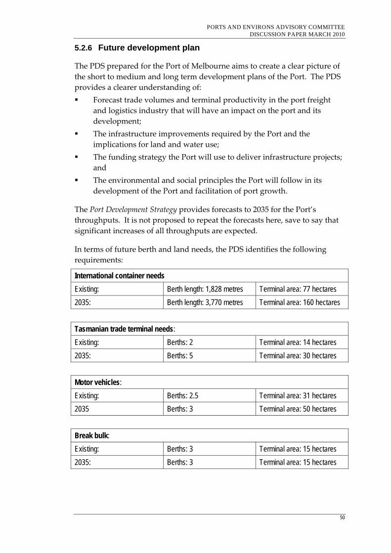
PORTS AND ENVIRONS ADVISORY COMMITTEE DISCUSSION PAPER MARCH 2010
50
5.2.6 Future development plan
The PDS prepared for the Port of Melbourne aims to create a clear picture of
the short to medium and long term development plans of the Port. The PDS
provides a clearer understanding of:
Forecast trade volumes and terminal productivity in the port freight
and logistics industry that will have an impact on the port and its
development;
The infrastructure improvements required by the Port and the
implications for land and water use;
The funding strategy the Port will use to deliver infrastructure projects;
and
The environmental and social principles the Port will follow in its
development of the Port and facilitation of port growth.
The Port Development Strategy provides forecasts to 2035 for the Port’s
throughputs. It is not proposed to repeat the forecasts here, save to say that
significant increases of all throughputs are expected.
In terms of future berth and land needs, the PDS identifies the following
requirements:
International container needs
Existing: Berth length: 1,828 metres Terminal area: 77 hectares
2035: Berth length: 3,770 metres Terminal area: 160 hectares
Tasmanian trade terminal needs:
Existing: Berths: 2 Terminal area: 14 hectares
2035: Berths: 5 Terminal area: 30 hectares
Motor vehicles:
Existing: Berths: 2.5 Terminal area: 31 hectares
2035 Berths: 3 Terminal area: 50 hectares
Break bulk:
Existing: Berths: 3 Terminal area: 15 hectares
2035: Berths: 3 Terminal area: 15 hectares
PORTS AND ENVIRONS ADVISORY COMMITTEE DISCUSSION PAPER MARCH 2010
51
Dry bulk:
No additional capacity required, however some minor relocation and consolidation of existing dry bulk trade may be required.
Liquid bulk:
No additional berths are required.
Passenger ships:
Adequate capacity is available at Station Pier.
In addition, the PDS identifies the following port‐related needs:
Valued added logistics – a range of port‐related activities may be located on‐
port to meet logistics requirements of key users and operators to enhance the
Port’s competitive position. These activities include:
Cold stores;
Packing and unpacking depots; and
Distribution centres.
The objective of the PDS is to locate these activities within the Port ‘where
possible’, including within the Dynon precinct.
Freight terminals and empty container parks – these facilities provide critical
functions including storage and serving of empty containers, providing a
time buffer for delivery and receipt of full containers at strategic locations
near the Port and outer metropolitan locations.
The PDS identifies the following precincts:
Williamstown – Ann Street Pier
Ann Street Pier is currently used for the storage and mooring of marine
equipment, such as tugs, barges, pontoons, workboats and survey vessels.
The precinct will continue its multi‐purpose role for the foreseeable future.
Williamstown – Gellibrand Pier
Gellibrand Pier will be retained for liquid bulk (crude oil) pack type.

PORTS AND ENVIRONS ADVISORY COMMITTEE DISCUSSION PAPER MARCH 2010
52
Williamstown – Breakwater Pier
Breakwater Pier will be retained to ensure the security and safety of the
adjacent Gellibrand Pier. Breakwater Pier is also considered to be a strategic
port asset for use as a future liquid bulk berth or for special purposes such as
visiting naval ships, vessel lay up and large plant storage.
Newport
The Newport precinct includes oil pipelines and jetties used by adjacent oil
companies. The precinct will be retained as a key asset for the petroleum
industry and as a park, managed in partnership with Parks Victoria.
Webb Dock
Webb Dock can be developed in stages and could potentially handle a
similar capacity to Swanson Dock if required. The first stage of the proposed
development in the short to medium term will involve a portion of the east
side of the dock being converted to international containers to accommodate
terminal capacity of 1 million TEU. In the longer term to around 2025, the
remainder of the east side of the dock may be converted to containers and
the west side of the dock will become the Port’s major coastal terminal
precinct. Displaced motor vehicles will be relocated elsewhere within the
Port or to another Victorian port. Break bulk trades will be accommodated
elsewhere in the Port.
The reconnection of rail to Webb Dock will be considered consistent with
trade demand and the longer term.
It is envisaged that by 2035 this precinct could handle a similar number of
containers to Swanson Dock.
Yarraville
The Yarraville precinct will retain its multi‐purpose dry and liquid bulk
functions in the short to medium term and appropriate development of
acquired PoMC properties.
Coode Island
The precinct is used as a storage facility for importing and exporting bulk
liquids. Because it serves a vital State role, Coode Island is to be retained for
bulk liquid operations in the long term.
PORTS AND ENVIRONS ADVISORY COMMITTEE DISCUSSION PAPER MARCH 2010
53
Holden Dock
Holden Dock will be retained for bulk liquid operations for the long term.
Swanson/Appleton/Victoria Dock
Swanson Dock East and West will continue to be used for international
carriers for the long term. This will involve an intensification of trade
through the dock with some expansion to the north possibly being necessary
to cater for future shipping needs.
Trade through Victoria Dock will also increase in the short to medium term,
with substantial new investment currently underway. The eastern edge of
Victoria Dock is reserved for the future Webb Dock rail link, if required.
This precinct will be integrated with the Dynon rail precinct to the north of
Footscray Road following relocation of the Melbourne Wholesale Fruit &
Vegetable market.
Intensive development of the Swanson/Appleton/Victoria Dock precinct for
international containers and general cargo is planned to take place during
the short to medium term to ensure sufficient capacity and productivity to
accommodate forecast demand.
South Wharf
South Wharf is used for a range of activities, including break bulk and dry
bulk cargos, bulk cement imports and ancillary services. The limited width
of the wharf area, particularly with the Webb Dock rail corridor, makes the
wharf area ideally suited for its current activities and will continue to be
used for these activities for the long term.
Station Pier
Station Pier is used as the Melbourne Sea Passenger Terminal and is the only
cruise liner facility in Melbourne. The precinct will continue to be used by
TT‐Line, cruise liners and naval vessels visiting Melbourne.

PORTS AND ENVIRONS ADVISORY COMMITTEE DISCUSSION PAPER MARCH 2010
54
5.2.7 Key interface issues
While there is some general reference to the interface issues in the PDS, the
PEPF provides a more detailed analysis of these matters.
The PEPF identifies the following land use challenges for Melbourne Port:
Protecting the amenity of residential development and foreshore areas
in locations such as Docklands, Garden City, Port Melbourne,
Williamstown and Footscray;
Providing for continued operation of major hazard facilities at Coode
Island and Gellibrand Pier;
Ensuring that future development in neighbouring areas does not
impede long‐term port development;
Protecting arterial land transport connections and Freight Activity
Centres from adjoining development with unrealistic amenity
expectations;
Continuing operation of South Wharf and recommissioning of the
Webb Dock rail link whilst balancing land use changes in Fishermans
Bend; and
Balancing development pressures in sought‐after Williamstown with
the needs of the Port and the BAE ship building facility.
The PEPF makes the following principal recommendations:
Strengthening the land use planning objectives for the Port and its
future development which are expressed by both the PoMC and the
Victorian Government;
Adopting an approach to management of land use change that aims to
protect both the interests of the Port and its neighbours; and
Ensuring that planning frameworks provide a basis for consideration of
environmental, amenity and safety management issues in land use
decisions by proponents and responsible authorities.
The PEPF also makes recommendations for:
Enhancements to the SPPF to provide greater recognition and
protection of the Port and to particular provisions relation to defining
caretaker houses in the VPPs;
Administrative and procedural improvements to the planning system;
Policy changes to the Port of Melbourne Planning Scheme;
Policy changes to the Local Planning Policy Frameworks of the
Melbourne, Port Phillip, Hobson’s Bay and Maribyrnong Planning
PORTS AND ENVIRONS ADVISORY COMMITTEE DISCUSSION PAPER MARCH 2010
55
Schemes to provide policy support and protection for the Port of
Melbourne; and
Changes to the business zones abutting the port in Melbourne and
Maribyrnong Planning Schemes.
Specific zoning and overlay changes recommended in the municipal
planning schemes include:
Melbourne Planning Scheme – the schedule to the Business 3 Zone in
Fishermans Bend be amended to include a floor space limitation for
offices which restricts the intensification of such uses in proximity to
the operational port;
Maribyrnong Planning Scheme – land in the Business 2 Zone between
Lyons Street, Moreland Street and Footscray Road be rezoned to
Industrial 3 to address amenity interface issues with the port,
particularly the major hazardous facilities;
Hobson’s Bay Planning Scheme – with the exception of the possible
changes near Gellibrand Pier, the existing zoning and overlay
framework is considered appropriate; and
Port Phillip Planning Scheme – no changes are recommended.
5.3 Port of Hastings
5.3.1 Location and context
The Port of Hastings is located on the western arm of Western Port,
approximately 60 kms south east of Melbourne’s CBD. Over 3,500 hectares is
zoned for port‐related uses, however the area currently used for port and
port‐related uses is much smaller.
Figure 2 shows the location of the Port of Hastings relative to surrounding
areas.
The Port of Hastings has two main areas: Crib Point and Stony Point, located
south of the Hastings township; and Long Island located to the north of the
Hastings township.
Land to the east and south of Crib Point and Stony Point is developed with a
mixture of residential, rural residential, industrial and farming purposes.
Land to the east and north of Long Island is developed for rural residential
and farming purposes.
The Port of Hastings area of interest land is located within a designated
Ramsar site.

PORTS AND ENVIRONS ADVISORY COMMITTEE DISCUSSION PAPER MARCH 2010
56
Figure 2: Port of Hastings and surrounding areas
PORTS AND ENVIRONS ADVISORY COMMITTEE DISCUSSION PAPER MARCH 2010
57
5.3.2 Governance arrangements
The Port is managed by the Port of Hastings Corporation, which has a Port
Management Agreement with Patrick Port Hastings (a division of Asciano
Ltd) to manage the port land, jetties and channels. This lease expires in 2012,
with the option of a 5 year extension.
In July 2010, the Port of Melbourne Corporation will replace the Port of
Hastings Corporation as the authority responsible for the Port.
5.3.3 Nature of trade throughput
The major trades at Hastings Port include:
Steel – slab steel is brought to Hastings by BlueScope for the
manufacture of various sheet metal products including corrugated iron,
zincalume and flat steel supplied to car manufacturers. The steel is
primarily for the domestic market with some exported from the Port;
Oil and gas – Bass Straight crude is pumped to the former Esso storage
facility at Long Island Point from Longford (Gippsland) via a 180 km
pipeline. Some of this is exported as gas or oil via the Long Island Jetty,
and some is piped to Altona/Geelong; and
Petrol – fuel is imported through Crib Point and piped to United
Terminal’s storage and distribution facilities north of Hastings.
In the 2007/08 financial year, trade volume reached 2.95 million tonnes,
comprising:
1.79 million tonnes of petroleum products; and
1.16 million tonnes of steel products.
5.3.4 Current infrastructure
The main facilities at the Port include State‐owned infrastructure at Long
Island Point, Crib Point and Stony Point, as well as privately owned land and
infrastructure at the BlueScope Steel Wharf.
Long Island Point Jetty. This jetty is a single oil/gas berth, with a design
capacity to accommodate vessels 300 metres long.
Crib Point Jetty. This jetty has two bulk liquid berths. Berth No 1 has a
design capacity to accommodate vessels 300 metres long, and is used to
import ULP which is then piped to Hastings. Berth No 2 was constructed as
part of the BP refinery development located adjacent to the jetty. Both the
refinery and jetty have been decommissioned, however the berth can provide
temporary lay‐up facilities for vessels.
PORTS AND ENVIRONS ADVISORY COMMITTEE DISCUSSION PAPER MARCH 2010
58
Stony Point Jetty. This jetty is 190 metres long and is used as the
headquarters for port control and harbour services. The jetty also handles
passenger ferries to Cowes and French Island and small commercial vessels
up to 60 metres long.
5.3.5 Road and transport issues
As evident by the title of the Port of Hastings Land Use and Transport
Strategy, a significant element of the plan relates to transport issues.
Currently, the Port is connected to the broader network by rail (Stony Point
Line) and via local and regional road networks.
Key road routes include Western Port Highway linking Hastings with
Dandenong and Melbourne’s south eastern suburbs; Tyabb‐Tooradin Road,
South Gippsland Highway and Koo Wee Rup Road linking Hastings to
Gippsland; and Frankston Flinders Road linking Hastings to the proposed
Frankston Bypass and East Link.
A target of the PLUTS is to have freight split 50% between road and rail,
which is acknowledged as a ‘stretch target’.
Regional access actions include:
Develop Western Port Highway to freeway standard from the north to
Tyabb—Tooradin Road;
Support the construction of Frankston Bypass;
Improve Tyabb‐Tooradin Road, South Gippsland Highway and Koo
Wee Rup Road with a local bypass of Koo Wee Rup Road;
Encourage appropriate east‐west freight routes such as Thompsons
Avenue and Greens Road through to East Link;
Establish port‐related road freight routes; and
Upgrade McKirdys Road to provide direct access to Western Port
Highway.
Local road access actions include:
Establish specific port‐related local road traffic routes;
Extend Bayview Road to provide a direct connection with Western Port
Highway;
Create a connection between Western Port Highway and Watts Road
(with a grade separation over the Frankston‐Stony Point rail line) and
widen Watts Road through to Reid Parade; and

PORTS AND ENVIRONS ADVISORY COMMITTEE DISCUSSION PAPER MARCH 2010
59
Improve local roads required to link Hastings with Mornington
Peninsula Freeway corridor and Frankston thus avoiding built‐up
residential areas.
Rail improvement actions include, at the regional level:
Further detailed assessment of rail corridor capacities and options for a
preferred rail corridor; and
In the long‐term, connect the port with Dandenong and Gippsland
regions along a preferred route.
At the local level, actions include:
A rail connection between the existing BlueScope/Esso spur and “Old
Tyabb Reclamation Area”;
Upgrade signalling/safe working environments on the Hastings to
Frankston section to allow off‐peak freight train operations; and
Enhance the capacity of Hastings‐Frankston corridor by either
providing crossing facilities at selected locations or by duplicating the
entire track length.
5.3.6 Future development plan
The Port of Hastings will be a secondary port to the Port of Melbourne after
2035 once the Port of Melbourne reaches capacity. It is this context that
provides an understanding of the future growth of this Port.
The PLUTS includes development plans for the three precincts of Long
Island, Crib Point and Stony Point.
Long Island Point – this is the preferred site for a new port operations centre,
and three stages of development have been proposed:
Stage 1 – a multi‐purpose berthing facility in a 50 hectare reclamation
area between the Long Island and BlueScope jetties. The facility will
accommodate 3 berths of 300 metres each, capable of handling bulk,
break bulk, cars and general cargo.
Stage 2 – development of a series of container berths and associated
landside infrastructure in a 400 hectare site to be reclaimed north of the
existing BlueScope jetty.
Stage 3 – Expansion and integration of Stage 1 and Stage 2 of the
development.
Crib Point – this precinct will continue to be used as a liquid berthing
facility, however not all land may be required and scope exists for
community, recreational and environmental uses for this area. The areas of
PORTS AND ENVIRONS ADVISORY COMMITTEE DISCUSSION PAPER MARCH 2010
60
State owned land between Crib Point and Stony Point are identified for
environmental rehabilitation and management.
Stony Point – this precinct is currently used as a port operations centre, it is
expected that this precinct will become available for community, tourism and
recreational uses, including a continuation of passenger ferry services and
potentially a car ferry service.
The PLUTS is underpinned by a number of principles to ensure the natural
environment is protected and its activities are environmentally sustainable.
Many areas of the port and surrounds have environmental significance,
including the Ramsar wetlands.
5.3.7 Key interface issues
The Port of Hastings is a largely undeveloped port, however Port Futures
identifies it as having a major role once Melbourne Port reaches capacity in
about 25 years time. Currently the main freight activity involves oil and gas
and steel.
Accordingly, the PLUTS’ overall objective is to create a comprehensive
framework and process for enabling the timely and sustainable expansion.
With respect to planning and interface issues, the planning principle is:
· To implement land use frameworks which can balance the port’s
operational and efficiency needs with the need to protect the amenity
and natural environment of the surrounding area and provide clear
guidance to existing and potential port users, the community and
regulators.
The PLUTS notes that local government has a critical role to play in
administering the Special Use Zone that applies to the Port, however
suggests that given the State significance of the port that it may be appropriate
that planning decisions are taken at the State level for port and infrastructure
development within the defined port precincts, particularly the Long Island precinct.
In addition, the Port representatives tabled a Land Use Assessment Report
for the Stage One (Long Island) development, which was prepared for the
Port by AECOM. The report states there is a need to:
Prepare a specific zoning control to facilitate the Port of Hastings (Stage
One) Core Development Precinct, which supports the use and
development of the land for port development;
Introduce planning provisions to manage safety with regards to
locating new facilities near the former Esso plant;

PORTS AND ENVIRONS ADVISORY COMMITTEE DISCUSSION PAPER MARCH 2010
61
Reserve land for the development of a road and rail access corridor
with appropriate zones and overlays to be determined following more
detailed design;
Identify private land which may need to be acquired to facilitate the
development of the road and rail access corridor; and
Consider the most appropriate responsible authority of the Port of
Hastings – Core Development Precinct.
The PLUTS does not refer to issues concerning the port’s interface with
surrounding land uses, other than to recognise the significance of the natural
environment and the need to minimise amenity impacts through its transport
initiatives.
5.4 Port of Geelong
5.4.1 Location and context
The Geelong Port is located 75 kms south west of Melbourne and 15 kms
north of the Geelong CBD.
The port area included in the Special Use Zone is approximately 90 hectares,
and there is also a wider adjoining ‘port area of interest’ of approximately
226 hectares in the Industrial 2 zone.
The ‘port Area of interest’ also includes the Shell Refinery of 119 hectares.
The Princes Highway and Corio Bay provide the boundaries to the west and
east respectively.
A substantial residential area exists between the southern and northern parts
of the port, which contains approximately 200 houses and 480 people. This
area is the suburb of North Shore.
There is also a substantial residential area to the west, on the west side of the
Geelong‐Melbourne railway line. This is the suburb of Norlane.
The port area also adjoins a residential area to the south.
Figure 3 shows the Geelong port and surrounding areas.
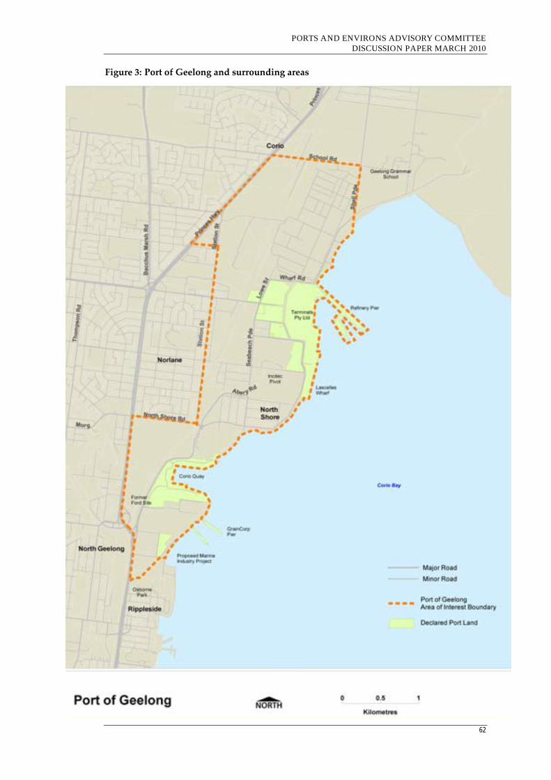
PORTS AND ENVIRONS ADVISORY COMMITTEE DISCUSSION PAPER MARCH 2010
62
Figure 3: Port of Geelong and surrounding areas

PORTS AND ENVIRONS ADVISORY COMMITTEE DISCUSSION PAPER MARCH 2010
63
5.4.2 Governance
The State Government sold the port land and port based structures at the
Port of Geelong to Ports Proprietary Ltd in the late 1990s. The port is now
managed by GeelongPort on behalf of three shareholders, Hastings Funds
Management (35%), Reef Infrastructure ((35%) and Asciano (30%).
GeelongPort owns approximately 29 hectares of vacant industrial land
adjacent to Lascelles Wharf. The balance of the land is owned by other
private port operators or industries.
5.4.3 Nature of trade throughput
The port’s major trading products are:
Crude and oil petroleum products – 60 percent;
Woodchips – 15 per cent;
Fertiliser – 12 per cent;
Grain – 1 per cent; and
Aluminium products – 4 per cent.
There has been a relatively steady increase of the trading products over the
past five years, with total trade of 10,875,533 tonnes in 2007/08.12 Expansion
and improvements to existing infrastructure is expected to lift trade by 35%.13
5.4.4 Current infrastructure
The port’s infrastructure includes:
Berths, piers and wharves; and
Cargo handling facilities, on the back‐up land behind the berths.
Specialised berths are provided to handle the different cargo types traded
through the Port. The commercial shipping berths include:
Lascelles Wharf ‐ 3 berths, break and dry bulk;
Corio Quay North and South ‐ 4 berths, break and dry bulk;
GrainCorp Grain Pier ‐ 1 berth, dry bulk;
Refinery Pier ‐ 4 berths, liquid bulk; and
Point Henry Pier ‐ 1 berth, dry bulk.
12 Trade Through the Port of Geelong: Economic Indicators 2007/08 – Planning Strategy &
Economic Development – City of Greater Geelong 13 GeelongPort Information Brochure
PORTS AND ENVIRONS ADVISORY COMMITTEE DISCUSSION PAPER MARCH 2010
64
5.4.5 Road and transport issues
Roads
Access to the Port of Geelong from the State’s arterial road system is
available from local arterial road networks. The principal north‐south route
is Corio Quay Road/Seabeach Parade/Shell Parade. Connections are also
available to the Princes Freeway and Geelong Ring Road at its northern end.
The Ring Road will be able to service the majority of port‐related traffic
travelling to and from western Victorian and South Australia.
In 2008, VicRoads prepared the Geelong Freight Linkages Study, which
identifies the principal freight routes, short‐term improvements and possible
future road connections.
Major recommendations are:
Geelong‐Bacchus Marsh Road should be recognised as the main route
from the Geelong Ring Road to the Port.
Cox Road will provide a support function to Geelong‐Bacchus Marsh
Road for access to the Port, this route is less attractive to heavy vehicles
due to the geometry of the Princes Highway/ Geelong‐Bacchus
Marsh/Cox Road intersection. The Cox Road area is also the subject of
an urban renewal project which would be incompatible with high levels
of heavy vehicles.
Existing access to the Heales Road Estate from Geelong ‐Bacchus Marsh
Road, Broderick Road and the Princes Freeway/Forest Road off/on
ramps is adequate for current levels of development. The Geelong Ring
Road project includes provision for future access ramps oriented
towards Melbourne at Broderick Road, which will support future
capacity needs between the Heales Road industrial area and
Melbourne.
Geelong Bacchus Marsh Road and Bayside Main Road (Shell Road)
have been identified as the key port freight routes for future planning.
Rail
The Port of Geelong is connected to the State’s standard and broad gauge rail
network by rail lines running northward (to Melbourne) and westward (to
western Victoria and Adelaide). There are also local rail connections to a
number of the Port’s facilities, including Corio Quay North, Corio Quay
South, GrainCorp’s grain receivable facility, Lascelles Wharf, Incitec Pivot
fertiliser works and Midway site.
The PLUS identifies a number of operational constraints associated with the
rail network servicing the port. These include the level crossings at

PORTS AND ENVIRONS ADVISORY COMMITTEE DISCUSSION PAPER MARCH 2010
65
Thompson Road and Separation Street which limit the length of trains
accessing the GrainCorp facility and shunting into Corio Quay requires the
use of the main line to Melbourne.
Recent improvements have been made to the rail infrastructure, including
the dual gauge Corio Independent Goods Line, off the Geelong Grain Loop
to North Shore, connecting Midway Pty Ltd to the standard gauge network.
The PLUS identifies future improvements, as follows:
Australian Government has committed up to $50 million towards
upgrading the standard gauge rail access to the Port; and
Preliminary finding that an inter‐modal terminal (IMT) could be
established providing a shuttle service for containerised freight, on
standard gauge, between the Port of Geelong and Melbourne. Location
options for an IMT are Lara and the Heales Road Industrial Estate.
5.4.6 Future development plans
The PLUS identifies a number of precincts for the future planning of the port
and port area of interest, and are summarised as follows:
Liquid Bulk Precinct – this precinct is located in the northern parts of the
Port, and includes the Shell refinery and Terminals Pty Ltd. Land to the west
of the railway line serves as a buffer to the residential areas further west. The
available area for liquid bulk is considered adequate and no extension to the
precinct is proposed. However, some of the main planning opportunities for
this precinct include:
Investigating new industry opportunities for the undeveloped land at
Oyster Cove, including potential biodiesel operations;
Investigating the potential opportunities for foreshore initiatives, and
bicycle and pedestrian paths subject to addressing security and public
risk issues;
Improving the environmental values of Cuthbertson and Cowies
Creeks.
Bulk and Break Bulk Precinct – this precinct is located in the central parts of
the Port, and is designated for the use of dry bulk and break bulk activities
and consist of two key port areas, Corio Quay and Lascelles Wharf.
Significant users in this precinct are Incitec Pivot (fertiliser
production/storage)14; One Steel (steel products) and a range of small service
industries not necessarily connected with the Port.
14 The Advisory Committee was advised by GeelongPort that Incitec Pivot has ceased operations at
its site. It is not known whether this is a temporary or permanent closure.
PORTS AND ENVIRONS ADVISORY COMMITTEE DISCUSSION PAPER MARCH 2010
66
Main planning opportunities for Lascelles Wharf include:
Expanding the facilities at Lascelles Wharf to meet capacity
requirements to 2025, including provision of crane facilities at No 1
berth; extend the existing wharf at the southern end by about 150
metres and construction of one new berth; and
Development opportunities for vacant or available land at OneSteel and
Incitec Pivot;
Main planning opportunities for Corio Quay include:
Support the development of port and port‐related industries on the
former Ford site;
Expand the facilities at Corio Quay to meet capacity requirements for
2020 by providing additional berths to be constructed at both the north
and south sides of the Quay;
Investigate opportunities to extend Moorpanyal Park to the south of the
developed park area.
Dry Bulk Precinct – this precinct is located in the southern part of the port,
and is designated for the use of dry bulk activities. Major features of this
precinct include two Grain piers, one owned by GrainCorp and the other by
Geelong Port. This precinct also contains the former Classweave Textile
factory (Mill Market) and Osborne House which now houses the Geelong
Maritime Museum.
The PLUS does not identify potential development opportunities in this
precinct, but notes that the City of Greater Geelong has developed the
Geelong Marine Industry Project, which is to provide boating related
industries.
Point Henry precinct – this precinct is located on the other side of Corio Bay,
some distance from the main Port area. It is used by Alcoa for shipping
aluminium product. Planning opportunities identified include:
Investigate the potential new industrial and/or value adding industries
that may be sited in the undeveloped industrial land that would be
compatible with Alcoa.
5.4.7 Geelong Port Structure Plan
The Geelong Port Structure Plan, prepared by the City of Greater Geelong, has
been developed primarily as a tool to be used by the Council to determine
the application of local planning policy, planning zones and overlays and the
consideration of applications for planning permits and rezoning.
PORTS AND ENVIRONS ADVISORY COMMITTEE DISCUSSION PAPER MARCH 2010
67
The Structure Plan was adopted by Council in October 2007 and includes
objectives and strategies relating to:
Port economic role and function;
Land use needs;
Health and safety;
Environment and recreation;
Amenity buffers;
Transport; and
Physical infrastructure.
The Structure Plan identifies four precincts, including:
Precinct 1 – Refinery
Precinct 2 – Lascelles
Precinct 3 – Corio Quay
Precinct 4 – Grain Piers
The Structure Plan does not include Point Henry.
Council has requested that the Minister for Planning authorise an
Amendment to implement the Structure Plan. The Minister has advised
Council that it would be inappropriate for the Amendment to be exhibited
while the Advisory Committee was reviewing the planning controls on ports
and their environs.
Notwithstanding the Minister’s advice that it would be inappropriate to
exhibit an Amendment to introduce the Geelong Port Structure Plan, the
Committee has given detailed consideration to many of the Structure Plan’s
recommendations. The Committee considers that because the Structure Plan
has provided a more detailed consideration of many of the interface issues
than the land use strategy prepared for GeelongPort, it has been a helpful
document in determining the port environs and the nature of planning
controls that may be appropriate for the interface areas. However, the
Committee considers that having two different strategies relating to the
port’s future creates confusion and can lead to unjustified expectations. In
the future, it is preferable that there is only one land use strategy plan for the
Port of Geelong, not two.
5.4.8 Key interface issues
The Port of Geelong PLUS identifies four directions relevant to planning and
interface issues:
PORTS AND ENVIRONS ADVISORY COMMITTEE DISCUSSION PAPER MARCH 2010
68
Ensure the continuing availability of appropriately located sites for
future port and port‐related industries which support economic growth
in Geelong;
Establish effective buffer arrangements around the port to ensure the
future development of sensitive land uses does not unreasonably
constrain its development and operation, and that the port’s impacts on
neighbouring communities are minimised;
Ensure that effective safety, security and environmental management
practices are adopted so that the port and port‐related activity does not
unreasonably impact on the surrounding areas; and
Support future reviews of planning provisions aimed at providing
more certainty for particular developments, within a transparent
process, while also ensuring that community and environmental
interests are identified and protected.
Strategies of most relevance under these four directions are as follows:
Availability of appropriately located land:
Ensure that existing industrially zoned land in the ‘port area of interest’
is retained for port‐related and industrial uses, as well as providing a
port buffering role;
Investigate opportunities to utilise vacant or currently available
industrial land within the ‘port area of interest’ including the former
Ford site, the OneSteel site and potentially the Incitec Pivot site, for
port‐related or associated value adding industries; and
Ensure protection of the Heales Road Industrial estate as a priority
location for port‐related or associated value adding industry outside,
but accessible to, the ‘port area of interest’.
Effective land use buffers
Develop a comprehensive port buffer strategy to address existing and
potential interface issues between the operating port, industrial land
uses and more sensitive land uses;
Retain all existing industrial zoned land within the ‘port area of
interest’ to maintain its integrity as a land use buffer between the port
and sensitive land uses;
Review the area south of Mackey Street (Geelong Marine Industry
Project) to provide a land use transition, whilst retaining all the existing
industrial zoned land in an industry zone;
Retain the industrial land between the railway line and the Princes
Freeway as a buffer to the Shell Refinery; and
PORTS AND ENVIRONS ADVISORY COMMITTEE DISCUSSION PAPER MARCH 2010
69
Develop a specific local plan designed to protect the amenity of the
North Shore residential area.
Effective safety, security and environmental management practices
Promote integrated environmental management planning for all sites
currently within the ‘port area of interest’ including those not subject to
SEMP or EPA approvals requirements; and
Restrict ‘Controlled Port Activities’ to the Liquid bulk precinct.
Effective land use planning and approval framework
Provide greater transparency in port planning by adopting a precinct
based approach within the ‘port area of interest’, identifying discrete
precincts each of which has its own characteristics and issues;
Support the port precinct planning approach in Council’s Port Structure
Plan, and appropriate amendments to the Greater Geelong Planning
Scheme;
Strengthen planning policy frameworks to provide clear strategic
support for future port operations in a manner that achieves sustainable
development outcomes; and
Consider and advocate changes to the existing zone provisions in the
‘port area of interest’ to better accommodate port‐related development
and reduce the likelihood of the port’s future development being
unreasonably constrained by inappropriate or ad hoc development.
The Port of Geelong Structure Plan prepared by Council contains many
detailed strategies that address the same issues as the PLUS. However, there
are some points of difference, including:
The Structure Plan excludes Point Henry;
The Structure Plan identifies three precincts, the PLUS identifies four;
The Structure Plan includes proposals for pedestrian/cycle paths and
future connections and environmental improvements to creeks;
The Structure Plan seeks to limit the Liquid Bulk Storage precinct role
of storage of hazardous goods to the Terminals’ site lease; and
The Structure Plan identifies a range of application requirements for
bulk liquid storage, whereas the PLUS relies on existing processes (e.g.
Clause 52.10, EPA works approval).
In addition, the proposed Amendment prepared by Council to implement
the Structure Plan includes a number of rezonings. Council understands that
GeelongPort does not oppose the rezonings, other than a small parcel of
Reserved Crown land near Mackay Street from Industrial 2 to Public
Conservation and Resource Zone.

PORTS AND ENVIRONS ADVISORY COMMITTEE DISCUSSION PAPER MARCH 2010
70
However, the Advisory Committee notes that in GeelongPort’s submission it
states that all current industrially zoned land should be retained within its
current zoning. Further, GeelongPort is concerned that the Council’s
maritime precinct proposal includes tourism accommodation and the
potential for a Special Use Zone which it believes would not be compatible
with the Port of Geelong operations.
As noted previously, the Minister has advised Council that it would be
inappropriate for the Amendment to be exhibited while the Advisory
Committee is reviewing the planning controls on ports and their environs.
5.5 Port of Portland
5.5.1 Location and context
The Port of Portland is located within the coastal town of Portland, about 360
kms south‐west of Melbourne. It is located in the area known as the ‘Green
Triangle Region’, which has a strong economic base in agriculture, timber,
fishing and manufacturing industries.
The port covers an area of approximately 65 hectares occupying two separate
parcels of land with the main area extending from Henty Beach (Trawler
Wharf) to the southern end of the Incitec Pivot plant.
The Port also owns a parcel of land separate from the port located between
the Henty Highway and Canal Court. This parcel of land is known as Canal
Court and covers an area of approximately 8 hectares.
Figure 4 shows the Portland Port and surrounding areas.
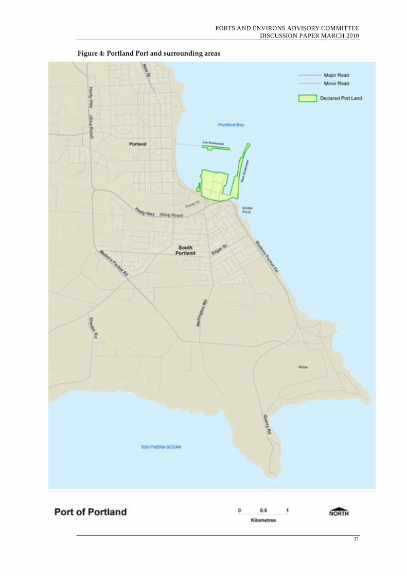
PORTS AND ENVIRONS ADVISORY COMMITTEE DISCUSSION PAPER MARCH 2010
71
Figure 4: Portland Port and surrounding areas
PORTS AND ENVIRONS ADVISORY COMMITTEE DISCUSSION PAPER MARCH 2010
72
5.5.2 Governance
The Port and associated land tenures were purchased from the State
Government in March 2006. The Port is owned and operated by the Port of
Portland Pty Ltd, a private company managed by Hastings Funds
Management.
5.5.3 Nature of Trade throughput
The Port of Portland specialises in the storage and handling of bulk
commodities. Trade volumes to the year ending 30 June, 2008 were:
Forestry products – 1,407,000 tonnes;
Smelter products – 1,085,000 tonnes;
Grain – 10,000 tonnes;
Fertiliser – 452,000 tonnes;
Mineral sands – 201,000 tonnes; and
Other 98,000 tonnes.
This represented an increase of 7% from the previous year.
Recent trade volumes have been impacted by very low grain exports caused
by drought. However, it is expected that trade will grow significantly due to
new export trade volumes from maturing hardwood plantations and the
mining and processing of mineral sands.
5.5.4 Current infrastructure
The port is divided into six separate precincts:
Bulk commodities and smelter;
Lee Breakwater;
Marine;
Canal Court;
Incitec Pivot; and
Portland foreshore.
The bulk commodities and smelter precinct comprises:
Fisherman’s wharf;
Storage and berth areas for bulk forestry (soft and hardwood chips and
logs);
Mineral sand, grain and overflow storage areas;
Storage and berths for Portland smelter imports;
Livestock berths;
PORTS AND ENVIRONS ADVISORY COMMITTEE DISCUSSION PAPER MARCH 2010
73
Liquid pitch storage facilities; and
A conveyor belt for alumina.
The Lee Breakwater is 1179 metres long and contains the berths for two
harbour tugs. It is open to the public for both vehicular and pedestrian
access (except during bad weather) and provides an opportunity for
recreational fishing in relatively deep water.
The marine precinct comprises Trawler Wharf, slipways and various marine
businesses. The wharf accommodates Portland’s trawler fishing fleet as well
as itinerant vessels.
Canal Court comprises storage space and distribution facilities for port‐
related freight. A rail marshalling yard is located along the southern
boundary of the site.
The Incitec Pivot precinct accommodates the Incitec Pivot plant, which is a
large industrial facility for the processing and storage of fertiliser products.
The foreshore precinct includes the Portland foreshore between the western
edge of the port and the Lee Breakwater.
5.5.5 Road and transport issues
The PLUS states that improved road and rail infrastructure within the region
and in the approaches to the Port are essential to support increased business
and associated industrial development of the Port.
The PLUS notes that the construction of the Cliff Street overpass has been
essential in improving access to the Port.
Specific strategies to improve road and rail infrastructure include the
following:
Develop proposals to manage heavy vehicle traffic access for other local
and arterial roads that lead to the Port. This would include the
implementation of the Access Management Policy for the Henty
Highway ‘Ring Road’ and dedication of 24 hour/7 seven day curfew
free access to the Port;
Based on the outcomes of the Port master plan, prepare a detailed
traffic management plan to manage the throughput of trucks through
the Port to accommodate estimated delivery volumes of timber and
other commodities from 2009 onwards;
Review operations and identify the need for a truck marshalling area to
be developed within close proximity to the Port;
PORTS AND ENVIRONS ADVISORY COMMITTEE DISCUSSION PAPER MARCH 2010
74
Advocate for the re‐opening of the Heywood to Mount Gambier
railway line reservation; and
Lobby the federal and state governments to improve the rail network
and infrastructure in accordance with a number of completed studies.
5.5.6 Future development plans
The PLUS contains a number of strategies for the future planning of the six
precincts. The strategies are predicated on a proposal to prepare a port
master plan to assist the ongoing planning and development of the port
incorporating:
Storage and handling areas for all tenancies;
Revised access arrangements (road and rail);
Security arrangements;
Location of administrative functions;
Environmental obligations;
Future development zones;
Land use arrangements for Canal Court; and
New berth developments.
Bulk commodities and smelter
Investigate opportunities to relocate Port services not dependent on
being within close proximity to berths to alternative sites, such as Canal
Court, in order to provide additional space for activities dependent on
locations near berths; and
Ensure product handling activities which have the potential to generate
dust, noise and light spill occur away from the precinct’s land side
boundaries where possible.
Lee Breakwater
Pending on‐going security and operational requirements, continue to
provide public access to Lee Breakwater for recreational and tourism
pursuits.
Marine
Review opportunities to improve:
Slipway;
Cray fisherman berths;
Urban design and amenity enhancements for the Fisherman’s
Wharf interface; and
PORTS AND ENVIRONS ADVISORY COMMITTEE DISCUSSION PAPER MARCH 2010
75
Commercial opportunities on land between the Trawler Wharf
and west of the Fisherman’s Wharf.
Canal Court
Investigate opportunities to relocate the Port administration building
and other non‐Port‐dependent activities; and
Investigate opportunities to rearrange the rail sidings to incorporate an
area for truck queuing.
Incitec Pivot
No development opportunities are identified, however the PLUS states that
the Port should continue to liaise with Incitec Pivot on environmental
management issues and to manage development pressures adjacent to their
site.
Portland foreshore
No development opportunities are identified, however the PLUS states that
it needs to ensure the protection of the Port’s assets and that the port
manager must be made aware of any issues with the potential to impact
upon its operations.
5.5.7 Key interface issues
The PLUS includes the following key planning principles and strategies
relating to planning and interface issues:
Effective planning for adjoining urban areas
· Identify and manage any adverse consequences to people, the
environment and property in the future planning for the Port and its
environs.
· Planning for areas adjoining the Port environs area needs to:
- Recognise the lifestyle values and amenity expectations of residents in the areas;
- Take into account the effect of the Port operations on the affected land; and
- Avoid introduction of activities that would prejudice the efficient and effective operations of the Port.
Specific changes recommended to the land use planning framework and
approvals process include:
Recognition of the State significance of the Henty Highway as a major
transport route servicing the port in the State Planning Policy
Framework;

PORTS AND ENVIRONS ADVISORY COMMITTEE DISCUSSION PAPER MARCH 2010
76
Managing land use changes to prevent the encroachment of sensitive
land uses around the port’s boundaries; and
Managing land uses changes to prevent the encroachment of sensitive
land uses adjoining freight networks.
5.6 Conclusion
While there are differences in the size, function and geographic location of
Victoria’s four commercial ports, the Committee notes a number of
similarities which have implications for their strategic and statutory
frameworks. These similarities include that all ports:
are experiencing continued growth in throughput and forecasts expect
growth to continue;
are comprised of different precincts catering for different port
functions;
have documented plans for infrastructure development and other
improvements to increase efficiency and cater for forecast growth; and
have interface issues that require/would benefit from appropriate
recognition in the planning framework.

PORTS AND ENVIRONS ADVISORY COMMITTEE DISCUSSION PAPER MARCH 2010
77
Part C - Port Environs
PORTS AND ENVIRONS ADVISORY COMMITTEE DISCUSSION PAPER MARCH 2010
78
6. Approaches to interface planning in the port environs
6.1 Introduction
The strategic role of Victoria’s ports means that they need to be able to
operate 24 hours a day, seven days a week. This need is related to
international and national shipping schedules and the efficient use of
landside loading/unloading facilities and transport infrastructure. As a
result of these activities and hours of operations, ports can generate amenity
impacts beyond their boundaries which can cause nuisance to uses in the
port environs considered ‘sensitive’ such as residential development or
certain community facilities.
The coastal location of ports and, in the case of Melbourne, Geelong and
Portland, the inner urban setting means that areas near these long‐
established ports are now sought‐after residential areas. In addition to the
waterfront location of such residential areas, there are aspects of living near a
commercial port that some residents find attractive such as the movement of
ships, tugs and other vessels or the visual dynamics and night time lighting
of wharf infrastructure.
The Advisory Committee considers that recognition of the strategic and
economic importance of ports at the national, state and local levels needs to
be predicated on awareness of the context in which long‐established ports
are located. The planning and management of this interface between ports
and their neighbours is, arguably, as important as planning and management
within the ports themselves.
The Committee notes that the Port of Melbourne’s draft Port Environs
Planning Framework (2009) identifies a range of mechanisms that may be
considered appropriate to address the adverse amenity impacts of
incompatible land uses. The Committee has used that material as a starting
point for the identification of conceptual approaches to interface planning for
the port environs. In addition, there are a range of stakeholders involved in
the management of interface issues including the ports themselves, state and
local government and the community. The approaches and stakeholders are
discussed in the following sections.
PORTS AND ENVIRONS ADVISORY COMMITTEE DISCUSSION PAPER MARCH 2010
79
6.2 Approaches to interface planning and management
The range of approaches to interface planning which may be relevant to the
port environs are summarised in the following sections. References to
examples of these approaches currently used in the ports under
consideration or included in the VPPs are included where relevant.
6.2.1 Creating buffer areas
Separating incompatible land uses by means of physical distance, in other
words, by means of a buffer area, is a common land use planning mechanism
that is used to allow a use which generates adverse amenity impacts to
operate without causing unreasonable nuisance to adjoining or nearby
sensitive uses. With this approach, an area of sufficient width or other
characteristics such as topographical features is identified between the
impact‐generating use and other uses to mitigate adverse impacts. This
separation may also be enhanced by controls on the intensity, form and
location of incompatible activities.
Where an existing use does not have sufficient space within its existing
boundaries to provide a buffer, it could purchase land beyond its boundary,
particularly where there may be a small area of a sensitive use whose
continuance may otherwise constrain efficient operations of the impact‐
generating activity. This land could be incorporated into the boundary of the
impact‐generating activity or be made available for development for
compatible uses.
Under contemporary planning practice, buffer areas are usually contained
within the boundaries of the landholdings of the impact‐generating use. For
example, in the VPPs, Clause 52.10 Uses with Adverse Amenity Potential
which has as its purpose:
To define those types of industries and warehouses which if not
appropriately designed and located may cause offence or unacceptable
risk to the neighbourhood.
This clause sets out the minimum threshold distance from any part of the
land of the proposed use or buildings and works to land (not a road) in a
residential zone, Business 5 Zone, Capital City Zone or Docklands Zone, land
used for a hospital or an education centre or land in a Public Acquisition
Overlay to be acquired for a hospital or an education centre.
For the longer‐established ports of Melbourne, Geelong and Portland, the
Committee considers that there are few opportunities to develop buffer areas
within existing port boundaries. However, in the case of Hastings, the

PORTS AND ENVIRONS ADVISORY COMMITTEE DISCUSSION PAPER MARCH 2010
80
extensive areas included in the Special Use Zone provide the potential for the
planning of future port development and port‐related uses to incorporate
buffer areas as appropriate.
6.2.2 Planning controls to create ‘reverse buffers’
With this approach, an area external to the site boundaries of the impact‐
generating use is identified in which the type of uses are limited and/or the
nature of built form is controlled to allow the impact‐generating use to
operate without restriction. In effect, the onus is on any new nearby use to
demonstrate that it would not compromise the operation of the existing use.
A clear expression of the ‘reverse buffer‘ concept included in the VPPs is the
Airport Environs Overlay. This overlay applies in several planning schemes
including:
Hume Planning Scheme around Melbourne Airport as the Melbourne
Airport Environs Overlay (MAEO) with two schedules which control
use and development relative to forecast levels of aircraft noise
exposure. The purposes of this overlay as it applies around Melbourne
Airport include:
To ensure that land use and development are compatible with the
operation of Melbourne Airport in accordance with the relevant
airport strategy or master plan and with safe air navigation for
aircraft approaching and departing the airfield.
To assist in shielding people from the impact of aircraft noise by
requiring appropriate noise attenuation measures in dwellings and
other noise sensitive buildings.
To provide for appropriate levels of noise attenuation depending on
the level of forecast noise exposure.
A key intention of this overlay is to control the number of people and
dwellings adversely affected by aircraft noise. The extent of this
overlay is usually related to either forecasts of the extent of specified
levels of exposure to aircraft noise or the nature of the underlying zone.
This overlay is a statutory planning tool to give effect to a ‘reverse
buffer’.
Kingston Planning Scheme applying to areas around Moorabbin
Airport ‐ Schedule 1 to this Overlay prevents the granting of a permit
for a range of nominated ‘sensitive’ uses despite the provisions of the
underlying zone. Policy basis for this overlay is provided in Clause
22.05‐1 of the MSS which recognises ‘….the need to ensure that the use and
PORTS AND ENVIRONS ADVISORY COMMITTEE DISCUSSION PAPER MARCH 2010
81
development of land around the Moorabbin Airport is sensitive to the long
term operation of the airport’.
Strathbogie Planning Scheme applying to areas around Mangalore
Airport where it controls subdivision and includes as a decision
guideline the ‘views of the airport owner’ along with other
considerations including compatibility with airport operations and
whether the proposal incorporates noise attenuation measures.
A similar overlay if applied to port environs ‐ however determined ‐ could
introduce an administrative process under the Planning and Environment Act
1987 to enable the port to be:
a referral authority in relation to planning permit applications for
certain types of uses or developments – this role would require the port
to respond and defend its position in relation to proposals within its
environs which it perceives have the potential to adversely constrain
operations or development;
given notice about certain categories of applications and the onus is on
the ports to respond if the applications are of interest. If no response is
received, the responsible authority could reasonably assume that the
application is of no interest or concern to the port;
or both roles as allowed for under Clause 66.10 of the VPPs.
6.2.3 Extend the range of sensitive uses
In this approach, the identification of uses considered to be ‘sensitive’ is
extended beyond residential accommodation to include other uses such as
child care centres, educational establishments, hospitals and, possibly,
offices, cafes and shops.
As a result, the establishment and/or expansion of such sensitive uses would
be considered through the prevailing planning controls in relation to either
the on‐going operation and/or forecast expansion of the impact‐generating
use. Expanding the range of ‘sensitive uses’ could progressively constrain
the operations and future development of existing impact‐generating uses.
A port is generally not a ‘footloose’ activity, i.e. a port cannot readily relocate
to another location as can many industrial activities. As a result, allowing a
wider range of sensitive uses in the port environs could have serious
ramifications for the future development of a port ‐ particularly those in
established urban areas.
The Committee was advised by Port of Melbourne representatives that an
example of this situation could be emerging in the Lorimer Street area in
Fishermans Bend. Office development in this area is attracting supporting
PORTS AND ENVIRONS ADVISORY COMMITTEE DISCUSSION PAPER MARCH 2010
82
uses such as cafes with outdoor areas with certain amenity levels that may be
inconsistent with a location in close proximity to operating port areas. The
PEPF also referred to this situation.
6.2.4 Improve environmental and/or operational performance
With this approach, the impact‐generating use improves its environmental
performance through, for example, reducing its emissions which have
adverse effects beyond its boundaries such as noise levels, light spill, or the
generation of dust or odours. As a result, this improved environmental
performance could reduce the need for other interface management
approaches such as buffer zones within or beyond the boundary of the
impact‐generating activity. Such emission reductions may also have benefits
for the port operator such as improved occupational health and safety
conditions or reduced energy usage.
An example of this approach is the Port of Melbourne’s Safety and
Environmental Management Plan (2005). This Plan applies a ‘whole of port’
approach to improving the safety and environmental performance of all
operations in the port – both those under direct control of the PoMC as well
as over other uses where it has influence only.
The North Shore Residents Group, representing residents of the North Shore
area within the ‘port area of interest’ in Geelong (as discussed in Section
5.4.1), in preliminary consultations with the Committee, acknowledged that
there had been improvements in the environmental performance of the
operation of Geelong Port and key port‐related uses within the port area
such as Incitec Pivot. The Committee noted that there are perhaps no
residents better placed to comment on the environmental performance of a
port operator than this group which participates in regular consultations
with Geelong Port through the Geelong Port Community Consultative
Committee.
In addition to improvements in environmental performance, port operators
can also institute a range of operational improvements that may have multi‐
faceted benefits of achieving efficiency improvements as well as amenity
improvements in neighbouring areas. An example of such measures include
improved time management of truck movements to assist loading and
unloading of ships which may reduce congestion on approach roads to the
port through ‘just‐in‐time’ arrivals.
The PoMC recently funded the Truck Optimisation Plan in order to better
understand and maximise efficiencies in landside container logistics (Annual
Report 2008‐09, p48). The Committee was advised that there is potentially
considerable scope for operational enhancements through the application of
PORTS AND ENVIRONS ADVISORY COMMITTEE DISCUSSION PAPER MARCH 2010
83
technological advances such as automated guided vehicles and cranes within
ports and high productivity freight vehicles and GPS monitoring beyond
ports.
The Committee notes that ports must also be aware of obligations to plan for
and manage their ‘waterside’ as well as their landside environs.
Parks Victoria, in its preliminary submission to the Committee, noted that:
While there are mandatory Safety and Environment Management Plans
in place for the commercial ports under the Port Services Act, any
planning for Port environs must continue to take account of the seaward
activities and risks as well as land‐based activities.
Another approach to enhancing environmental performance is the
implementation of improvements for the impacted recipient. Examples
include noise attenuation measures implemented in existing dwellings which
experience increases in noise levels above specified levels as a result of
projects such as road upgrades, airport expansions or nearby industrial
development. For example, the Commonwealth Government administered
programs to insulate residences near Adelaide and Sydney Airports where
increases in exposure to aircraft noise were experienced after capacity
enhancements at the airports. Levies on the tickets of aircraft passengers
using these airports funded these programs – an example of the ‘polluter
pay’ principle.
6.2.5 Site design and layout
Many impact‐generating uses are now required to prepare master plans for
their sites and operations – either at the establishment stage and/or at regular
intervals. Beneficial outcomes of such master planning activities for new
uses can be that more intrusive activities are located away from adjoining or
nearby sensitive uses and less intrusive activities, such as storage and
warehousing, closer to adjoining sensitive uses.
For long‐established uses, the scope for major site rearrangement may be
limited but the master planning process can assist, initially, in identifying
‘interface’ issues and ways in which progressive site improvements can be
made – usually involving a combination of interface management
approaches.
The requirement under the Port Services Act 1995 for operators of commercial
trading ports in Victoria to prepare a Port Development Strategy (commonly
known as a Port Land Use Strategy [PLUS]) at four yearly intervals is an
example of this approach. Under Section 91K (2) (b) of this Act, one of the
requirements a Port Development Strategy must include is:
PORTS AND ENVIRONS ADVISORY COMMITTEE DISCUSSION PAPER MARCH 2010
84
current and projected land use requirements, including transitional
land uses designed to protect the port from constraints on efficient
operations and mitigate adverse impacts of port operations on
adjacent uses; (emphasis added)
As discussed in the relevant sections of Chapter 4, the ‘first generation’ of
these land use strategies has been prepared for all four commercial trading
ports in Victoria. However, as yet, there is no explicit recognition of these
planning documents in the applicable planning schemes through
mechanisms such as acknowledgement in the SPPF or LPPF and/or inclusion
as an Incorporated Document or Reference Document. Such a nexus, if
achieved, could enhance certainty for all parties with responsibility for or
interest in interface planning for port environs.
6.2.6 Relocation of nuisance or hazardous activities
With this approach, nuisance or hazardous activities, often long‐established,
are relocated to a suitable site away from sensitive uses. A challenge with
implementing this approach is usually the ability to gain approval for new
sites for nuisance or hazardous activities. In the light of this difficulty,
existing nuisance or hazardous activities often remain in locations that may
be considered suboptimal relative to contemporary planning practice. As a
result, their interface issues need to be managed through other approaches.
Traditionally, areas within or adjacent to ports have been attractive for the
location of uses which are now identified as Major Hazard Facilities (MHF)
by virtue of the imported materials processed and/or stored prior to
transport/transfer elsewhere. On the one hand, there are strong logistical
reasons for such uses to be located within ports to facilitate materials
handling. However, actual incidents such as the explosion at Coode Island
in August 1991 or contemporary risk assessments have identified interface
issues.
Both the Coode Island facility in the Port of Melbourne and the Terminals
Pty Ltd facility within Geelong Port are identified as MHFs.
6.2.7 Legal agreements
Legal agreements can be made between the impact‐generating use and
occupiers or operators of sensitive uses to prevent complaints and legal
action being taken against the detrimental use. An example could be to
indemnify new owners from taking action against or complaining about the
impact‐generating use – assuming that impacts meet relevant standards or
fall within specified limits. This approach may be of limited utility in dealing
with port environs issues.
PORTS AND ENVIRONS ADVISORY COMMITTEE DISCUSSION PAPER MARCH 2010
85
6.2.8 Notice of potential detriment
A notice of potential detriment can alert potential buyers to an existing
nuisance associated with the off‐site impacts generated by an existing nearby
activity such as agricultural production. An example of this approach is the
inclusion of a specific notice under the Vendor’s statements provided as part
of a contract of sale for land under Section 32 of the Sale of Land Act 1962.
Under Section 32 (2) (cb) of this Act, one of the elements to be included in a
Vendor’s notice is:
a warning to the following effect—
ʹImportant notice to purchasers:
The property may be located in an area where commercial agricultural
production activity may affect your enjoyment of the property. It is
therefore in your interest to undertake an investigation of the possible
amenity and other impacts from nearby properties and the agricultural
practices and processes conducted there.ʹ
There may be potential for a similar notice to be applied in certain situations
in the port environs.
6.2.9 Acquisition of land and change of use
This approach would involve the voluntary acquisition of a sensitive use on
adjacent land by the impact‐generating land use and then achieving a change
of use and/or zoning to enable development of compatible uses. While this
approach can potentially achieve desirable outcomes, it has the
disadvantages of the high costs involved, the potential long timeframes to
achieve area‐wide outcomes and the perception by the community of ‘land
use creep’ by the impact‐generating land use.
The Committee understands that this approach has been used in relation to
heavily noise‐affected areas near airports or the purchase of individual
properties near wind farms to prevent on‐going complaints.

PORTS AND ENVIRONS ADVISORY COMMITTEE DISCUSSION PAPER MARCH 2010
86
6.2.10 Memorandum of understanding
A memorandum of understanding (MoU) can be made between the port
authority and other parties involved in managing interface areas such as the
local Council. A MoU is usually a non‐enforceable agreement about certain
actions to be undertaken by the respective parties to achieve specified
outcomes. MoUs are usually formalised expressions of good faith and rely
on other underlying measures for implementation and enforcement.
An example of this approach is the MoU that was agreed between Port of
Melbourne Corporation and Maribyrnong City Council in November 2006 in
relation to planning issues for the Footscray Wharf area on the western bank
of the Maribyrnong River. This MoU set out an agreed planning direction
for the port environs in Yarraville and included a statement of general
planning outcomes (principally amendments to the respective Planning
Schemes) as well as planning outcomes for specific areas. According to the
preliminary submission by the Council, the MoU has guided Council’s work
and approach in this area since then. However, the MoU is not mentioned in
the recommendations of the Draft PEPF for the Port of Melbourne. This
omission perhaps raises questions as to the utility of this mechanism for
interface management.
6.2.11 Conclusions
The Committee concludes that this wide range of approaches to interface
planning provides a useful guide to port operators to consider in their
planning and management to achieve appropriate outcomes in the port
environs. However, none of these approaches can or should be implemented
without appropriate consultation so the role of stakeholders in interface
planning needs to be considered – as discussed in the following section.
6.3 Planning tools under the VPPs
The Committee notes that the VPPs already incorporate several policy
settings and controls related to planning for interface areas to achieve land
use compatibility, namely:
The State Planning Policy Framework at Clause 17.03‐2 in relation to
industrial development states:
Industrial activity in industrial zones should be protected from the
encroachment of unplanned commercial, residential and other
sensitive uses which would adversely affect industry viability.
PORTS AND ENVIRONS ADVISORY COMMITTEE DISCUSSION PAPER MARCH 2010
87
Planning authorities should zone land for industrial development in
urban growth areas where good access for employees and freight
transport is available and where appropriate buffer areas can be
provided between the proposed industrial land and nearby sensitive
land uses.
Industrial 3 zone (IN3Z) which has as its purposes:
To provide for industries and associated uses in specific areas where
special consideration of the nature and impacts of industrial uses is
required or to avoid inter‐industry conflict.
To provide a buffer between the Industrial 1 Zone or Industrial 2
Zone and local communities, which allows for industries and
associated uses compatible with the nearby community.
To ensure that uses do not affect the safety and amenity of adjacent,
more sensitive land uses.
Clause 52.10 ‐ Uses with Adverse Amenity Potential which has as its
purpose:
To define those types of industries and warehouses which if not
appropriately designed and located may cause offence or unacceptable
risk to the neighbourhood.
This clause, which applies to new uses or buildings and works, specifies
the minimum distance from any part of the land of the proposed use or
buildings and works to land (not a road) in a residential zone, Business
5 Zone, Capital City Zone or Docklands Zone, land used for a hospital
or an education centre or land in a Public Acquisition Overlay to be
acquired for a hospital or an education centre.
Examples of location‐specific applications of other aspects of the VPPs which
assist with planning and management of ‘interface’ areas are discussed in the
following Chapter.
In the Committee’s view, the various planning tools under the VPPs could be
strengthened to address interface issues between sensitive and non‐sensitive
uses that would be relevant to apply to ports and their environs.
Opportunities to strengthen the VPP tools are as follows:
SPPF
The SPPF provides the opportunity to ensure that the strategic and economic
importance of Victoria’s four major commercial trading ports is given
statutory recognition. It can also outline the policies of the State with respect
to interface issues. Existing State policy could be retained or strengthened.

PORTS AND ENVIRONS ADVISORY COMMITTEE DISCUSSION PAPER MARCH 2010
88
LPPF
The LPPF of each of the planning schemes that control land in and around
ports provides the opportunity for the significance of the ports to the local
area to be given appropriate recognition. It can also set out policies with
regard to port development and interface issues from a local perspective.
Existing policies could be retained or strengthened.
Zones
Zones set down planning scheme requirements regarding the use,
development and subdivision of land as well as the requirements for
applications, decision guidelines and notification and review. At present
ports are included in Special Use Zones which group them with other uses
which do not fit into a specific class of land uses. Existing zones could be
retained or a new specific Port Zone could be introduced.
Overlays
Overlays supplement zone provisions to control the manner in which certain
uses or development may occur or to reinforce the importance of particular
circumstances which may apply to a specific area. Overlays cover a variety
of matters such as design and development issues, environmental matters,
native vegetation, flooding, wildfire, and heritage. In addition they can refer
to development plans or incorporated plans.
One option could be to apply the Design and Development Overlay (DDO)
in the identified port environs. An example of a DDO that could be applied
in identified port environs areas is included in Appendix H.
There may be potential for a specific port environs overlay to be introduced
to relate to areas around ports as a means to specifically address interface
issues at the development approval stage. There may also be the potential
for Port Master Plans to be the subject of an appropriate overlay as a
mechanism to facilitate the approvals process within ports. A draft of the
Port Environs Overlay has been prepared and is included in Appendix G.
Particular Provisions
Planning schemes contain a number of particular provisions which relate
specific matters. These include provisions relating to uses with potential
amenity impacts, car parking, residential development (ResCode), outdoor
advertising, petrol filling stations and the like. There may the opportunity to
introduce new particular provisions relating to port environs. An example of
a port‐specific clause is in Appendix J.
PORTS AND ENVIRONS ADVISORY COMMITTEE DISCUSSION PAPER MARCH 2010
89
Definitions
There may be shortcomings in the definitions included in the planning
scheme which give rise to ambiguities or confusion. There may be confusion
regarding the respective definitions of ‘port’, ‘wharf’, ‘jetty’ and ‘pier’ for
example or to uses which may be ‘port‐dependent’ on the one hand or ‘port‐
related’ on the other. The definition of ‘sensitive uses’ may also need to be
expanded.
Incorporated Documents
Incorporated Documents are documents which must be taken into account
during the consideration of applications for use and development. These
may include Government, Council or Port prepared documents but are
usually documents that have involved a consultative process in their
preparation. There could be the opportunity to have Port Land Use
Strategies included as Incorporated Documents to give greater status to new
development foreshadowed in these strategies if the preparation of these
strategies were shown to have been through a consultative process.
Reference documents
Reference documents are documents referred to in planning schemes to
provide background or context for the consideration of particular use and
development applications. They do not have the status of Incorporated
Documents but are nevertheless useful additions to a planning scheme to
assist in the decision making processes. These may include Government,
council or port prepared documents.
6.4 Stakeholders in interface planning
The Advisory Committee is aware that, in addition to the range of
approaches to interface planning for port environs, there are a range of
agencies and stakeholders variously involved in the implementation of most
of these interface planning approaches. These agencies and stakeholders are:
The port operator – through lease conditions as well as interaction with
external parties;
Port lessees – through lease obligations as well as interaction with
external parties;
State Government – through policy formulation at the state level and
enacting enabling legislation;
State government agencies – through implementation of specific
statutory responsibilities;

PORTS AND ENVIRONS ADVISORY COMMITTEE DISCUSSION PAPER MARCH 2010
90
Local government authorities – as responsible planning authorities and
through specific enforcement responsibilities as well as representatives
of the local community;
Community and interest groups – through participation in formal or
informal consultation opportunities; and
Individual property owners or occupiers ‐ through participation in
formal or informal consultation opportunities.
Opportunities for these stakeholder groups to participate in the
implementation of various approaches to the planning and management of
port interface areas is indicated in Table 5.1. Some of the opportunities for
stakeholder involvement have a statutory basis such as notice of Planning
Scheme amendments or referral of Planning permit applications to
prescribed agencies. Other opportunities are at the discretion of the port
operator.
Table 5.1 indicates that, as would be expected, the port operator has a
primary role to play in the implementation of many of these interface
management approaches. The State Government has a key role to play
through policy formulation and enacting legislation which sets the
framework for implementation of relevant mechanisms, usually undertaken
by particular government agencies such as the Environment Protection
Authority, Work Safe or VicRoads.
Opportunities for involvement by the community or individuals in these
interface management approaches varies. There is potentially little or no
involvement where the approach is largely one internal to the operation of
the impact‐generating activity. However, there are generally more
opportunities for stakeholder involvement when external (and often
statutorily‐required) processes such as approval processes are involved.
Good practice for port operators is to engage other stakeholders through
opportunities including, but not limited to, consultation on draft port land
use strategies, participation in Community Reference Groups and discussion
on particular issues.
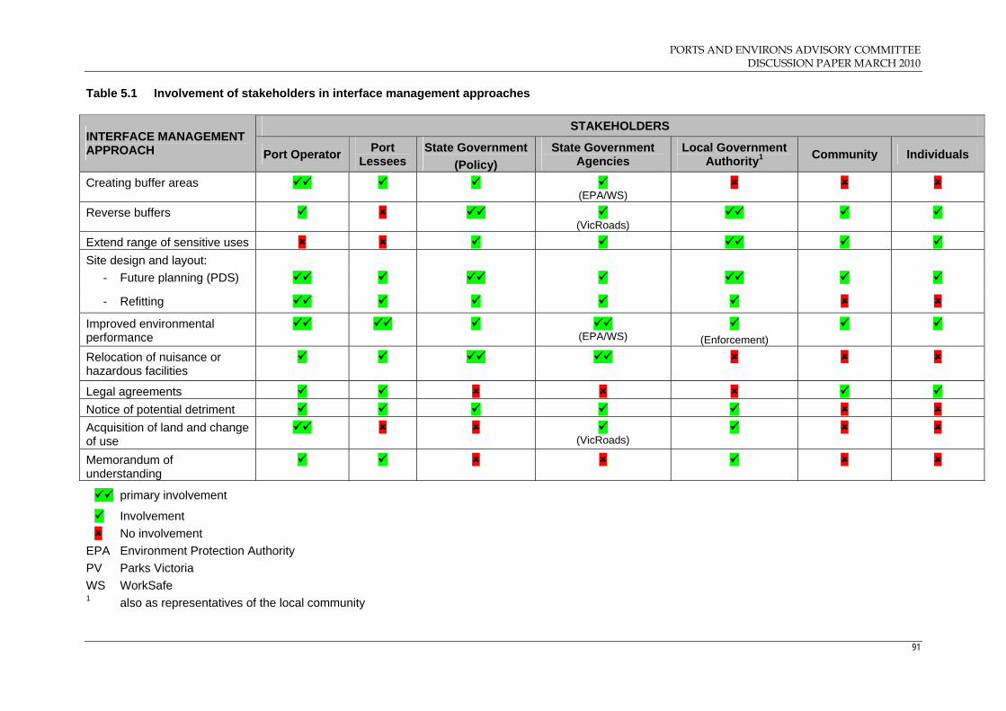
PORTS AND ENVIRONS ADVISORY COMMITTEE DISCUSSION PAPER MARCH 2010
91
Table 5.1 Involvement of stakeholders in interface management approaches
EPA Environment Protection Authority
PV Parks Victoria
WS WorkSafe 1 also as representatives of the local community
STAKEHOLDERS INTERFACE MANAGEMENT APPROACH Port Operator
Port Lessees
State Government
(Policy)
State Government Agencies
Local Government Authority1 Community Individuals
Creating buffer areas (EPA/WS)
Reverse buffers (VicRoads)
Extend range of sensitive uses
Site design and layout:
- Future planning (PDS)
- Refitting
Improved environmental performance
(EPA/WS)
(Enforcement)
Relocation of nuisance or hazardous facilities
Legal agreements
Notice of potential detriment
Acquisition of land and change of use
(VicRoads)
Memorandum of understanding
primary involvement
Involvement
No involvement

PORTS AND ENVIRONS ADVISORY COMMITTEE DISCUSSION PAPER MARCH 2010
92
6.5 Advisory Committee discussion
The preceding discussion clearly indicates that the management of interface
issues between impact‐generating activities and sensitive uses can involve a
combination of approaches which have differing opportunities for
involvement by stakeholders. As a result, interface management in locations
such as port environs can be a multi‐dimensional process that varies
according to particular circumstances and requires a complex interaction
with stakeholders.
One of the mechanisms identified in the Port of Melbourne’s PEPF report is
for the operator to improve the environmental performance of the port which
could have the effect of eliminating or reducing the need for other interface
management measures. The Committee notes that, in the land use strategies
prepared for each of the four ports, the port operators are committed to
improving their environmental performance to reduce any adverse impacts
on amenity. In the Committee’s view, improving environmental
performance of the ports should be the starting point for interface
planning particularly given that the ports operate to some, albeit varying,
degree in existing urban environments.
Further, the Committee considers that any reasonable scope to improve the
design, layout and efficiency of the ports is also an important opportunity
to eliminate or reduce adverse amenity impacts. This is preferable to an
approach where neighbouring land may be sterilised to provide an inactive
or, at least, a less active buffer.
With the pressure to intensify development of existing urban land and
reduce urban sprawl, greater emphasis needs to be placed on co‐existence
between potentially incompatible land uses rather than simply separating
incompatible land uses to the maximum extent possible. In relation to
strategically important ports, this approach requires that people residing or
working in neighbouring land uses to the ports have reasonable
expectations about the level of amenity which take into account the benefits
of living in or near waterfront and inner city locations.
In the Committee’s view, expectations are best managed when the
environmental performance of the ports are able to be measured in tangible
terms. There needs to be clear, and preferably quantifiable, standards in
terms of the environmental performance that must be met by the port
operators.

PORTS AND ENVIRONS ADVISORY COMMITTEE DISCUSSION PAPER MARCH 2010
93
The Committee concludes that further consideration of the following
approaches to interface planning and management is not warranted for the
following reasons:
Relocation of MHFs is beyond the scope of the ToR. Regulation of these
facilities is undertaken by the EPA and the Victorian WorkCover
Authority under relevant legislation;
Legal agreements which prevent adjoining or nearby sensitive uses
from lodging complaints and taking legal action against a detrimental
use are not appropriate because they are legally questionable in terms
of reducing a person’s right to take action and, even if not legally
questionable, could result in a detrimental use pursuing inappropriate
activities;
Relocating of a port per se is beyond the scope of the Advisory
Committee’s terms of reference.
In the next chapter, the Committee identifies the boundaries that would
constitute the port environs for each of the ports. From this analysis, the
Committee then considers whether the application of a planning tool under
the VPPs is appropriate to address the interface issues and if so, the actual
VPP tool that may be appropriate.
Key issues for consideration
Are there other approaches to interface management that should be
identified?
Have all the relevant stakeholder categories been identified?
What approaches to interface management are particularly useful in the
port environs?
PORTS AND ENVIRONS ADVISORY COMMITTEE DISCUSSION PAPER MARCH 2010
94
7. Identifying the port environs for Victoria’s four ports
7.1 Introduction
The ToR include the following task:
Make recommendations on appropriate boundaries for the land that
would constitute ‘port environs’ for all of the four commercial ports.
In approaching this task, the Committee has undertaken a detailed
examination of the interface areas between each of the ports and surrounding
areas that potentially contain sensitive uses having regard to:
the nature of existing uses and developments within each of the ports;
the future plans for each of the ports as identified in its land use
strategy;
the nature of existing and future uses and developments (if known)
surrounding each port;
relevant planning objectives and strategies in the various planning
schemes;
issues raised by key stakeholders; and
site inspections of the ports and surrounding areas.
From these investigations, the Committee is seeking comment as to whether:
the interface area beyond the specific port boundary should be
identified as a port environs area that requires some form of buffer
treatment;
the identified port environs area should be subject to a planning
mechanism under the statutory planning framework, such as an
alternative zone to restrict the type of uses or an overlay to control the
nature of development;
the port manager should be a prescribed authority under Clause 66.10
of the VPPs for notice and/or referral of applications in the port
environs; or
some other collaborative approach is appropriate between the port
manager and the operators of a sensitive use.

PORTS AND ENVIRONS ADVISORY COMMITTEE DISCUSSION PAPER MARCH 2010
95
The Committee has provided a detailed analysis to determine the key
interface areas for each of the ports in preference to a more arbitrary
approach that would simply delineate a certain distance from the port
boundaries to be included in the port environs. In the Committee’s view, an
arbitrary approach (Appendix J) may not be justified given the significant
variation in the nature of activities occurring within different parts of each of
the ports and the diversity of surrounding land uses and development. In
addition, an arbitrary approach may capture uses that are compatible with
port activities and do not require a buffer.
In determining the port environs for each port, it should be noted that in the
cases of the ports of Hastings and Geelong there are significant amounts of
land beyond that controlled by the port manager. However, in determining
the port environs for these two ports the Committee has considered the Port
of Hastings ‘boundary’ to include all the land in the Special Use Zone and
the Port of Geelong ‘boundary’ to be all the land identified as ‘Port Area of
Interest Land’ in the Port of Geelong Land Use Strategy.
For the ports of Melbourne and Portland, the Committee has referred to all
land directly controlled by the port manager as well as land included in a
port‐related Special Use Zone to determine the port boundary.
The Committee has noted that in the various documents relating to ports
there is reference to ‘port‐dependent’ and ‘port‐related’ uses. However,
there does not appear to be a standard definition of each. For the purposes
of this Paper, the Committee considers port‐dependent uses to be solely or
critically reliant on a port for its location and existence and port‐related uses
to be uses that have some business or functional connection to a port.
Key issue for consideration
Is a more detailed investigation of the interface areas of each of the
ports to determine the port environs more preferable than an approach
which arbitrarily identifies the port environs based on a certain
distance?
PORTS AND ENVIRONS ADVISORY COMMITTEE DISCUSSION PAPER MARCH 2010
96
7.2 Nature of amenity and risks at the interfaces
The Committee considers it is appropriate that the nature of amenity and
risks associated with ports and port‐related uses are identified.
From the information provided to the Committee, existing amenity impacts
from the operation of the four ports variously include:
Noise from port operations such as cranes, gantries, reversing vehicles
and movement of containers;
Airborne emissions from dust, fugitive odours and industrial activity
processes;
Vibrations from port and port‐related activities;
Light spill and glare; and
Appearance of and views to and across the port.
Local community concern about adverse amenity impacts from road traffic
noise is a vexed issue for the Committee. While such impacts could be more
significant for many local residents than other amenity impacts from port or
port‐related activities, road and transport matters are regulated by other
State policies and controls than the statutory planning framework. 15
However, it may be possible in some situations where an overlay could be
imposed along a transport corridor to mitigate the impacts of traffic noise.
For example, DDO1 in the Hume Planning Scheme requires development to
be designed to minimise the impact of traffic noise on noise sensitive
activities.16
With respect to risk, the main concerns relate to the handling and storage of
hazardous material such as oil and petroleum, fertilisers and various
chemicals within or adjacent to ports as well as the transportation of such
material to and from ports.
The Committee has considered the issue of risk in the context of Clause 52.10
of the VPPs, which sets out the EPA threshold distances for uses with
adverse amenity potential and risk. It is not the role of the Committee to
assess the performance of the industries that store, handle and transport
major hazards, nor to assess the performance of the EPA or WorkSafe
Victoria in monitoring the industries. Furthermore, it is not the role of the
15 For example, VicRoads Traffic Noise Reduction Policy 2005 16 Clause 43.02 of Hume Planning Scheme

PORTS AND ENVIRONS ADVISORY COMMITTEE DISCUSSION PAPER MARCH 2010
97
Committee to comment on the appropriateness of the EPA threshold
distances or WorkSafe safety guidelines.
Key issue for consideration
Are there other amenity impacts that should be identified in relation to port
operations?
7.3 Port of Melbourne
With its location in central Melbourne, the Port of Melbourne is the most
complex of Victoria’s four commercial trading ports in terms of the number
and diversity of sensitive interfaces.
From the PEPF and discussions with both PoMC and Council officers, the
Committee considers the important sensitive interfaces to be investigated
are:
Swanson Dock and Dynon precinct with South Kensington;
Appleton Dock and Dynon precinct with e‐Gate;
Swanson Dock (Coode Island) with Yarraville precinct;
Webb Dock with Garden City and The Strand, Williamstown;
Station Pier with Beacon Cove;
Appleton Dock, Victoria Dock and South Wharf with Lorimer Street
and Fishermans Bend;
Victoria Dock with Docklands;
Holden Dock and Francis Street with Newport and Yarraville; and
Ann Street Pier, Gellibrand Pier and Breakwater Pier with the former
Port Phillip Woollen Mills site (Williamstown).
The Committee notes that these nine interface areas account for almost all of
the Melbourne Port landside boundary.
7.3.1 Swanson Dock and Dynon precinct with South Kensington
Background
The Swanson Dock precinct includes the Swanson Dock international
container terminals, the Coode Island Major Hazard Facility (MHF) as well
as road and rail transport connections to the Dynon precinct and beyond.
Currently the land to the north of this precinct is zoned Industrial 1 and
Public Use 27 (Other Public Use) and the land to the north west is zoned
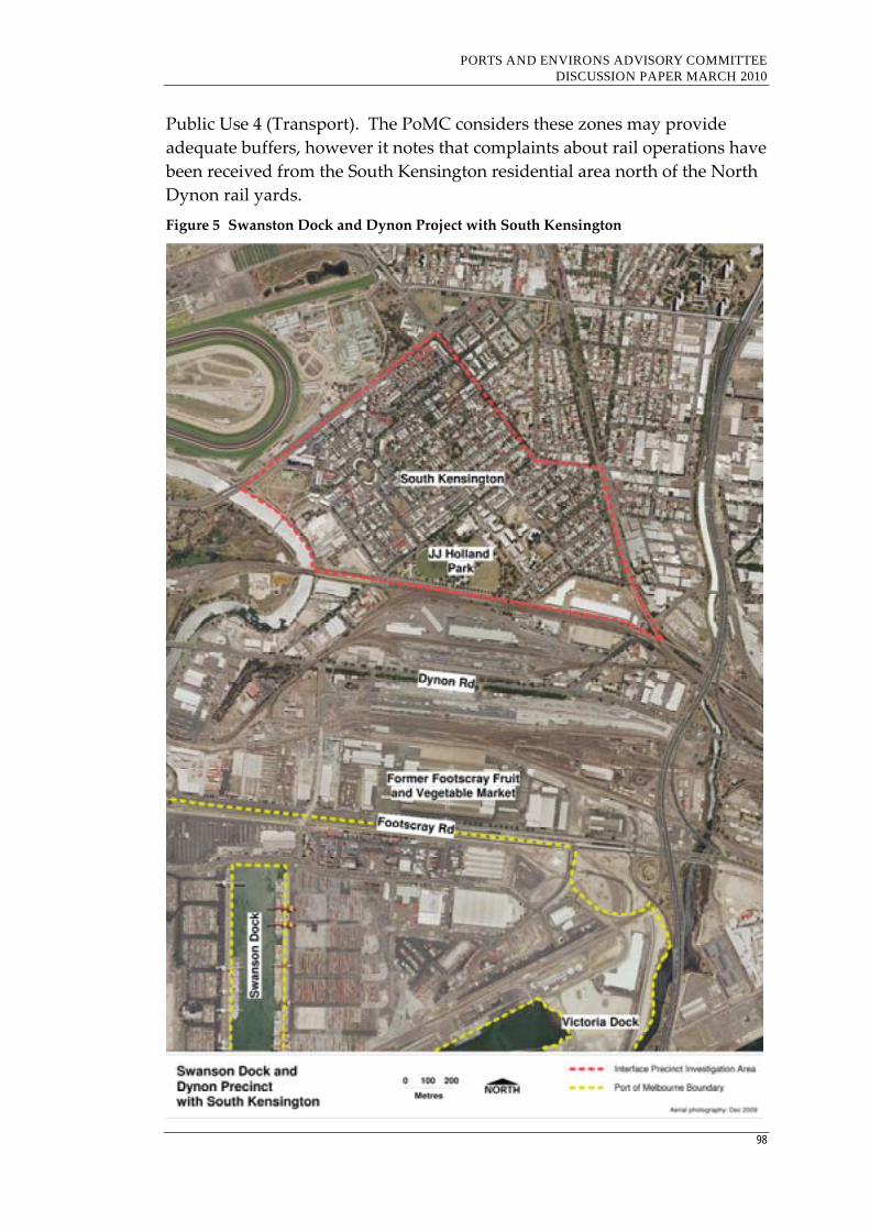
PORTS AND ENVIRONS ADVISORY COMMITTEE DISCUSSION PAPER MARCH 2010
98
Public Use 4 (Transport). The PoMC considers these zones may provide
adequate buffers, however it notes that complaints about rail operations have
been received from the South Kensington residential area north of the North
Dynon rail yards.
Figure 5 Swanston Dock and Dynon Project with South Kensington
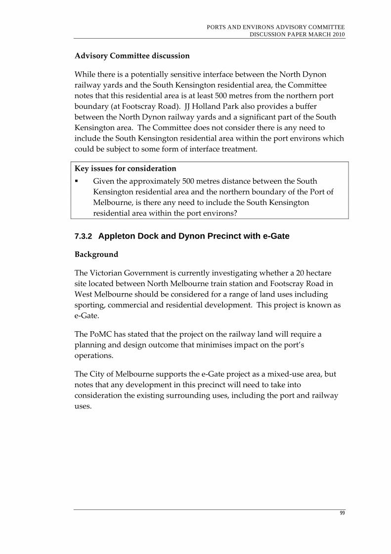
PORTS AND ENVIRONS ADVISORY COMMITTEE DISCUSSION PAPER MARCH 2010
99
Advisory Committee discussion
While there is a potentially sensitive interface between the North Dynon
railway yards and the South Kensington residential area, the Committee
notes that this residential area is at least 500 metres from the northern port
boundary (at Footscray Road). JJ Holland Park also provides a buffer
between the North Dynon railway yards and a significant part of the South
Kensington area. The Committee does not consider there is any need to
include the South Kensington residential area within the port environs which
could be subject to some form of interface treatment.
Key issues for consideration
Given the approximately 500 metres distance between the South
Kensington residential area and the northern boundary of the Port of
Melbourne, is there any need to include the South Kensington
residential area within the port environs?
7.3.2 Appleton Dock and Dynon Precinct with e-Gate
Background
The Victorian Government is currently investigating whether a 20 hectare
site located between North Melbourne train station and Footscray Road in
West Melbourne should be considered for a range of land uses including
sporting, commercial and residential development. This project is known as
e‐Gate.
The PoMC has stated that the project on the railway land will require a
planning and design outcome that minimises impact on the port’s
operations.
The City of Melbourne supports the e‐Gate project as a mixed‐use area, but
notes that any development in this precinct will need to take into
consideration the existing surrounding uses, including the port and railway
uses.

PORTS AND ENVIRONS ADVISORY COMMITTEE DISCUSSION PAPER MARCH 2010
100
Figure 6 Appleton Dock and Dynon Precinct with e‐Gate
Advisory Committee discussion
The Committee notes that the nominated e–Gate site is surrounded by
industrial and public use (transport) land which also separates this site from
the port. However, the Committee agrees with both PoMC and City of
Melbourne that any potential residential development will need to be
carefully planned to address potential impacts from the port and to ensure
that such development does not curtail port activities. Given the project is at
an early investigation stage, it is perhaps too early to recommend that e‐Gate
should be included within the port environs. However, it is important that
there is a collaborative approach between Major Projects Victoria, City of
Melbourne and PoMC during the investigative and feasibility processes.
Key issues for consideration
Is it too early to include the nominated e‐Gate project site in the port
environs?
What role should PoMC and other key stakeholders play in the
investigative and feasibility processes for the e‐Gate project?
PORTS AND ENVIRONS ADVISORY COMMITTEE DISCUSSION PAPER MARCH 2010
101
7.3.3 Swanson Dock (Coode Island) with Yarraville precinct
Background
Coode Island lies to the west of Swanson Dock and east of the Maribyrnong
River and contains the Coode Island MHF.
Terminals Pty Ltd owns and operates a bulk liquid hazardous chemical
storage facility on land leased from the PoMC. Chemicals handled at Coode
Island fall into three main groups based on their Dangerous Goods
Classification and on their potential to produce off‐site effects. In decreasing
order of this potential, they are:
Group 1 ‐ Acrylonitrile and propylene oxide;
Group 2 ‐ Flammable and toxic chemicals (e.g. benzene and ethyl
acrylate); and
Group 3 ‐ Combustible and corrosive chemicals and other low hazard
chemicals.
Terminals Pty Ltd receives liquid products by pipeline from ships and stores
these products in tanks. The chemicals are transferred by either bulk road
tankers or in 200 litre drums for transport off‐site. Many of the chemicals are
used in the production of paints, plastics, lubricating oils, detergents,
pharmaceuticals and health care products.
DP World operates the largest facility (a container terminal) on the Island,
handling about 400,000 containers of non‐hazardous goods each year,
together with some 12,000 containers and isotainers of dangerous goods from
Groups 1, 2 and 3. The 12,000 containers equate to approximately the same
volume of hazardous goods handled by Terminals Pty Ltd. Other operators
are King Transport who maintain a container storage area, and Pacific
Terminals and Gordon Brandon who operate low hazard storage facilities.17
On the west side of Maribyrnong River, there is an area between Footscray
Road to the north and Lyons Street to the south that is zoned Business 2.
This area is identified as Area A in a Memorandum of Understanding (MoU)
between PoMC and City of Maribyrnong. Further to the south of this
Business 2 area, the land is zoned either Industrial 1 or Industrial 3.
17 http://ciccc.org/coodeisland.htm
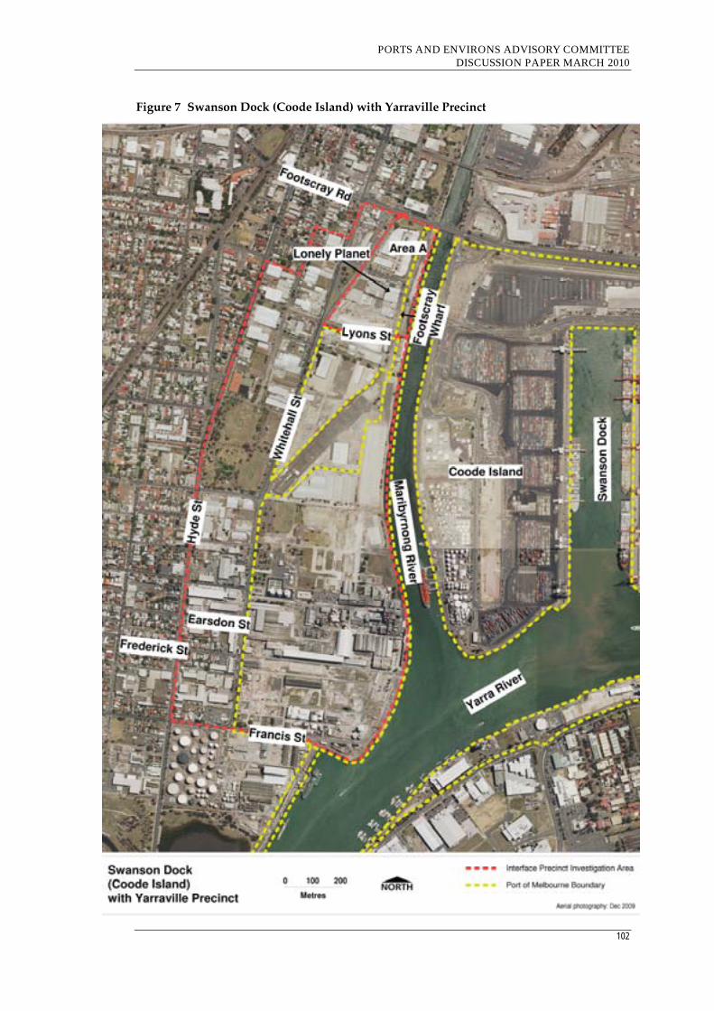
PORTS AND ENVIRONS ADVISORY COMMITTEE DISCUSSION PAPER MARCH 2010
102
Figure 7 Swanson Dock (Coode Island) with Yarraville Precinct

PORTS AND ENVIRONS ADVISORY COMMITTEE DISCUSSION PAPER MARCH 2010
103
The application of the Business 2 Zone reflects Maribyrnong Council’s
objectives to rejuvenate the area. Following a decline of riverfront industrial
businesses about 20 years ago, the stretch of waterfront between Lyons Street
and Dynon Road was earmarked for significant redevelopment as a business,
tourist and residential area offering new opportunities for business
investment and employment. Through land purchasers, capital works
investment, development facilitation and planning, Council set out to
encourage the redevelopment of this area and realise its potential as an
attractive waterfront location and gateway to the municipality.
There have been a number of projects that have helped achieved Council’s
vision for this precinct, including the reuse of the Port Phillip Mills building
and the development of the Lonely Planet headquarters. There was also a
proposal to establish a public marina and café/restaurant at Footscray Wharf,
however, this has not eventuated.
Council’s planning objectives to rejuvenate this area are a major concern for
the PoMC. In the PoMC’s view, the Coode Island MHF should be a major
consideration in defining the ‘port environs’ and providing a suitable buffer
between the MHF and sensitive uses. It notes that under Clause 52.10 of the
planning scheme, the threshold distance between the chemicals stored at
Coode Island and sensitive uses is one kilometre. Further, it notes that
WorkSafe Victoria’s draft outer risk area extends into the Business 2 zoned
land.
The PoMC considers Council should be promoting more intensive
development at the recently designated Footscray Central Activities District
(CAD), and that to promote major office development outside this CAD is
contrary to both State and local policy.
The PoMC’s position is that the Business 2 land in the northern part of the
Yarraville precinct should be rezoned to Industrial 3.
While Council has developed a long‐term strategy to rejuvenate the northern
section of the Yarraville precinct currently zoned Business 2, it considers that
the current controls are not effective and need strengthening.
In its preliminary submission to the Advisory Committee, Council officers
stated that Council is seeking to:
apply planning controls that do not quarantine the port environs;
allow uses and development that are able to co‐exist with the port; and
PORTS AND ENVIRONS ADVISORY COMMITTEE DISCUSSION PAPER MARCH 2010
104
allow uses and development that are ‘fair and reasonable’ to other
property owners and that offer ‘a proportionate’ response to the buffer
issues.
Further, Council considers that an evidence‐based approach is required to
understand the necessity for buffers and any changes to the planning
controls. The main interface issues have been identified as noise, light spill,
air emissions and risk/health, and that most concern relates to air emissions
and risk/health. For each of these elements, Council has sought an approach
that identifies whether the element requires buffering, the nature and extent
of the impacts and ways of mitigating the impacts.
Specifically, Council officers have advised that Council has in the MoU
proposed the following changes to the planning controls:
A new local policy based on the following principles:
- Residential uses will not be supported in the area;
- A preference for development similar to existing scale of
developments within Area A;
- All future development to acknowledge the proximity of the port
and port‐related uses and the need for on‐going efficient
operations of the port;
- The potential risk and amenity impacts of port operations on this
area and the interface role of this precinct given its proximity to
the port; and
- Appropriate management of historic contamination.
Rezoning of the Business 2 area to Business 3;
Use of a Design and Development Overlay; and
Potential for a floor space limitation.
Officers had previously recommended that an overlay control similar to the
Airport Environs Overlay be applied over the Area A land, however they
have been advised by the Department of Planning and Community
Development (DPCD) that such an approach is not supported.
Council officers consider the industrial zoning in the remainder of the
Yarraville precinct has prevented the encroachment of residential uses into
the buffer area. However, they note that, with the increasing value of
residential land, there is pressure from owners and occupiers of non‐
conforming dwellings in the Industry 3 Zone in Frederick Street and Earsdon
Street on Council for rezoning this small precinct to residential.

PORTS AND ENVIRONS ADVISORY COMMITTEE DISCUSSION PAPER MARCH 2010
105
Council officers have also expressed concern with establishment of
‘Caretaker’s houses’ in the Yarraville precinct. ‘Caretaker’s houses’ are a
permitted use subject to a permit in industrial zones and are as of right in the
Business 2 zone.
Under the VPPs, a Caretaker’s house is defined as follows:
A dwelling on the same site as a building, operation or plant, and
occupied by a supervisor of that building, operation or plant.
The concern is that some Caretaker’s houses which have been developed in
the area have no legitimate association with a building, operation or plant,
and have been a means to achieve residential development to take advantage
of the Yarraville address and the views to the city skyline. Council has had
some success in having such developments refused by VCAT.18
Both PoMC and City of Maribyrnong have sought to resolve the issues
through the signing of the MoU and the preparation of the PEPF Report. The
PEPF was preceded by a buffer strategy that had been prepared jointly for
the two organisations. 19 This strategy recommended that the Industrial 3
Zone and the Business 3 Zone be carefully considered to be applied to
Precinct A.20 It further recommended that a Design and Development
Overlay be introduced that includes design objectives, outcomes and
standards, including preferred building heights and setbacks as well as
measures to respond to and minimise risk from Coode Island.
Despite the attempts to resolve the issues, agreement has not been reached
between the two organisations on the statutory planning controls on the
northern part of the Yarraville precinct currently zoned Business 2.
Advisory Committee discussion
While the Yarraville precinct is identified in the various documents as port
environs, the Committee considers that not all the existing Industrial 1 and
Industrial 3 land south of Lyons Street and west of Hyde Street is a sensitive
interface.
It is clear that most of this land is used by major industry, which also
includes some large sites that are owned by PoMC. These industrial zones
provide an appropriate buffer between the port operations and the extensive
18 Collins v Maribyrnong CC [2009] VCAT 366 and Ogilvie v Maribyrnong CC [2008] VCAT 1920. 19 Issues Paper: Yarraville Port Environs Local Planning Policy 2008. 20 Precinct A includes the northern section of area and is bounded by Napier Street, the Maribyrnong
River, Moreland Road and Lyons Street.

PORTS AND ENVIRONS ADVISORY COMMITTEE DISCUSSION PAPER MARCH 2010
106
residential west of Hyde Street. Other than the City of Maribyrnong officers’
comments on Earsdon Street and Frederick Street, the Committee is unaware
of any suggestion to rezone these areas from industrial.
The Committee does not consider there is any justification for Council to
accede to pressure from residents in Earsdon Street and Frederick Street
within the Industrial 3 Zone to consider rezoning to residential. These
properties are within the one kilometre threshold distance of the Coode
Island MHF and are surrounded by existing industries to the north, east and
south.
Accordingly, the only area that requires any consideration for some form of
interface treatment is, in the Committee’s view, the Business 2 zoned land at
the northern end of the precinct (Area A in the MoU). While there is a
difference of view between the PoMC and City of Maribyrnong over the
future zoning of this area, the Committee notes that there has been some
movement by both parties to attempt to resolve the matter and that Council
has suggested some additional measures that seek to strengthen the nature of
the buffer by providing greater restrictions under their preferred Business 3
Zone.
In terms of whether the land should be rezoned to Business 3 or Industrial 3,
the Committee notes that, despite the different purposes of the two zones,
that there is very little difference between them as to the type of uses that are
prohibited. However, it is noted that the Industrial 3 Zone restricts office use
to 500 square metres and this appears to be a major concern of Council.
While the Committee does not have any information on the size of the offices
in this precinct, it has observed that many uses appear to be small scale office
use. Should these offices be less than 500 square metres, they would not
become non‐conforming uses in an Industrial 3 Zone. It would be helpful if
Council could provide more information about the nature and size of the
office uses in this precinct.
Despite the differences between the PoMC and City of Maribyrnong on the
future zoning of this part of the Yarraville precinct, it appears that with the
existence of the Coode Island MHF within the 1 kilometre threshold distance
under Clause 52.10 of the VPPs that there is no disagreement that this part of
the precinct should be included in the port environs.
Accordingly, further consideration needs to be given to the nature of
planning controls and processes that would be appropriate at this interface.
Specifically, these include whether:
PORTS AND ENVIRONS ADVISORY COMMITTEE DISCUSSION PAPER MARCH 2010
107
The northern part of the precinct should be zoned Business 3 or
Industrial 3;
A Design and Development Overlay should be introduced to address
potential amenity and risk impacts from the port in any development
proposals;
The floor space of individual developments should be limited; and
There is a need for the notice or referral of applications to the PoMC
under Clause 66.10 of the VPPs.
Further, the Advisory Committee understands PoMC’s concerns that Council
appears to be promoting major office development in the northern parts of
the Yarraville precinct outside the Footscray Activity Centre contrary to State
and local policy.
Finally, with respect to ‘Caretaker’s houses’, it would appear that both PoMC
and City of Maribyrnong share the same concern with applicants seeking to
exploit planning scheme provisions by establishing dwellings that have no
caretaker function. The Committee notes that a more stringent policy such as
that prepared by the City of Yarra may be appropriate to apply in the
Yarraville precinct.21 A further option may be to produce a particular
provision in the VPPs so that it has application across the whole of the State.
Key issues for consideration
Should the northern part of the Yarraville precinct currently zoned
Business 2 be included in the port environs?
If this northern precinct is included in the port environs, should:
it be zoned Business 3 or Industrial 3;
a Design and Development Overlay be introduced to address
potential amenity and risk impacts from the port;
floor space of individual developments be limited; and
the PoMC receive notice or referral of applications under Clause
66.10 of the VPPs.
Should major office development be promoted in this precinct outside
the Footscray CAD?
Is there any justification to rezone the existing dwellings in Earsdon
Street and Frederick Street to residential?
Should a local policy be prepared for ‘Caretaker’s houses’ similar to the
policy in Clause 22.06 of the Yarra Planning Scheme? Alternatively,
should there be a particular provision on ‘Caretaker’s houses’ be
prepared for the VPPs?
21 See Clause 22.06 of Yarra Planning Scheme
PORTS AND ENVIRONS ADVISORY COMMITTEE DISCUSSION PAPER MARCH 2010
108
7.3.4 Webb Dock with Garden City and The Strand
Background
Webb Dock is currently used as a multi‐purpose facility with berths for
motor vehicles and break bulk cargoes.
Environmental and amenity issues are addressed through the EPA
legislation and guidelines and through the implementation of the PoMC’s
Webb Dock Environmental Management Plan (EMP) and the Port Safety and
Environmental Management Plan (PSEMP). The Webb Dock Environmental
Effects Statement and the EMP were approved by the Minister for Planning
in 1999.
The development of Webb Dock is the next major project proposed by
PoMC. In the short to medium term, the east dock is proposed to be
converted for container handling with 1 million TEU capacity. In the longer‐
term, the west dock will also be developed and it is anticipated that the
capacity of Webb Dock will match current capacity at Swanson Dock. Break
bulk would be relocated elsewhere within the port and motor vehicles could
be relocated either within the port or to another Victorian port.
The PDS recognises the need to maintain an effective transition and buffer
zone between the community and the port.
Garden City is a residential area developed from the 1920s, and comprises
semi‐attached double‐storey houses arranged around a series of public open
spaces modelled on the Garden City Movement. It is covered by a Heritage
Overlay.
Garden City abuts the port’s boundaries at the corner of Todd Road and The
Boulevard. On the south west corner of this intersection is the 4 hectare
Perce White Reserve, developed as a nature reserve providing some passive
recreation. The reserve is within the port’s boundaries, however the reserve
is publicly accessible and is maintained and managed by Port Phillip City
Council.
In its preliminary submission to the Committee, City of Port Phillip officers
considered that the existing amenity impacts from Webb Dock to Garden
City include:
Air and noise emissions;
Light spill; and
The environmental impacts of water runoff.

PORTS AND ENVIRONS ADVISORY COMMITTEE DISCUSSION PAPER MARCH 2010
109
Figure 8 Webb Dock with Garden City
With any proposed development of Webb Dock for containerisation, Council
officers considered that there is a strong potential that there would be an
increase of air and noise emissions and light spill to Garden City.
It was submitted that:
The PoMC needs to be specific about the full range of likely impacts
from the proposed Webb Dock development;
There is a need for tangible performance standards to address air
emissions, noise emissions from the port, road traffic noise, light spill
and stormwater runoff that are clear to the community and are
regularly monitored and reported; and
The Environs Planning Framework Working Paper (2007) provides a table
of performance standards and solutions from the Webb Dock EMP.
The status of the proposed solutions should be updated and the
effectiveness of the solutions reviewed.
In addition, the Council officers submitted that a landscaped buffer and
acoustic wall on Port of Melbourne land is essential to ameliorate the off‐site
impacts of the port’s activities.

PORTS AND ENVIRONS ADVISORY COMMITTEE DISCUSSION PAPER MARCH 2010
110
It was noted that the Webb Dock Conceptual Development Plan in the Port
of Melbourne Planning Scheme indicates a 22.5 metre landscape buffer along
the western boundary of Todd Road, however the buffer is not included in
Design and Development Overlay 2 (DDO2).
Further, it was stated that the Panel that considered the Port of Melbourne
new format planning scheme in 2006 noted that neither the Conceptual Plan
nor the statutory controls were being modified at the time and suggested
that, in time, the buffer should be reflected in the schedule to the DDO.
Council officers sought the following outcomes:
DDO2 in the Port of Melbourne Planning Scheme enshrine the buffer
and provide specific details about its construction standards for
planting, height and quality;
All buffers should be designed, constructed and maintained fit for
purpose;
Planting must commence well ahead of development to ensure it is well
established before development commences; and
DDO2 in the Port of Melbourne Planning Scheme provide limits about
height of container storage, however, there is a let‐out clause for
‘temporary storage’. A definition of what is a temporary or short term
timeframe needs to be provided in the Scheme.
In its preliminary submission to the Committee, City of Hobsons Bay officers
expressed concern with the impact of the proposed development of Webb
Dock on views to the city skyline from Williamstown. They submitted that
any future development should not have a detrimental impact through
excessive mass, bulk or light. Similar to the City of Port Phillip, Council
officers considered that more information is required to assess the potential
impacts of the proposed Webb Dock development.
A number of Williamstown residents along The Strand have also expressed
concern in letters addressed to the Committee about the potential impact of
the proposed Webb Dock development and believe that the PEPF is deficient
because it does not include details of the Webb Dock development and its
potential amenity and risk impacts. These residents have also questioned
how the Advisory Committee is able to fulfil its tasks under the ToR without
considering the proposed Webb Dock development and its impacts.

PORTS AND ENVIRONS ADVISORY COMMITTEE DISCUSSION PAPER MARCH 2010
111
Figure 9 Webb Dock with The Strand (Williamstown)
PORTS AND ENVIRONS ADVISORY COMMITTEE DISCUSSION PAPER MARCH 2010
112
Advisory Committee discussion
Garden City
Given the close proximity between Webb Dock and Garden City, it is
reasonable for Port Phillip City Council to be concerned about the potential
amenity impacts of the Webb Dock development on Garden City residents.
Accordingly, it would appear appropriate that Garden City should be
included within the port environs.
The Committee does not have a role in assessing the proposed Webb Dock
development nor in reviewing the provisions of the Port of Melbourne
Planning Scheme. However, it supports Port Phillip City Council officer
comments that there is a significant opportunity for the PoMC to identify the
full range of amenity impacts from the proposed development in the
planning and design stage and that appropriate measures preferably with
tangible performance standards should be developed to mitigate potential
amenity impacts.
Further, the Committee supports the Council officer comments that the
landscape buffer along Todd Road provides a significant opportunity to
address potential adverse amenity impacts from the proposed Webb Dock
development. However, the Committee considers the nature of the buffer
and the timing of its development are matters that need to be considered as
part of the assessment process for the Webb Dock development.
The Committee notes that there a number of provisions in the Design and
Development Overlay (Schedule 2) of the Port of Melbourne Planning
Scheme that restrict the height of buildings, stored goods and materials in the
Webb Dock precinct. It would appear such controls have been designed to
address visual impact of port development from outside the port boundaries,
including from Williamstown. Any change to this control or any
development that exceeds these requirements should, in the Committee’s
opinion, be subject to consultation with the relevant Councils and
communities.
Despite the Committee’s opinion that Garden City should be included in the
port environs, it is not convinced that any additional planning controls
designed to restrict the type of uses to protect the port from the
encroachment of sensitive uses or control the nature of built form to reduce
potential amenity impacts from port activities will have any significant
benefit in addressing amenity concerns at this interface. Nor is the
Committee convinced that there would be any significant benefit in
PORTS AND ENVIRONS ADVISORY COMMITTEE DISCUSSION PAPER MARCH 2010
113
introducing a requirement for the notice or referral of applications to the
PoMC.
The Committee has adopted this stance because Garden City is a well
established residential area that is unlikely to go through significant change
in terms of the nature of uses or the type of built form. There are no
development sites that would allow significant new development and the
Heritage Overlay that applies to the area is likely to discourage
intensification of residential development. In other words, with little
prospect of new sensitive uses or the intensification and change to built form,
what purpose would additional planning controls and notice or referral
requirements have in addressing concern with the encroachment of sensitive
uses and potential amenity impacts from the proposed Webb Dock
development?
In relation to traffic and transport issues, the Committee notes that there is
little prospect that port‐related traffic will have a significant impact on
Garden City. However, the PDS has identified opportunities to address
adverse traffic impacts in the wider area, including the potential closure of
the Williamstown Road access and the re‐establishment of the Webb Dock
railway line. It is understood that the Plummer Street link also seeks to
provide a direct link to the freeway network.
The Strand
With respect to The Strand in Williamstown, the greater distance that
separates Webb Dock and The Strand compared to Webb Dock and Garden
City should assist with the reduction of potential amenity impacts of noise
and light spill of the proposed Webb Dock development.
In relation to concerns with visual impact from The Strand, the Committee
notes that residents on The Strand are living in a major capital city close to
Australia’s largest commercial trading port and should therefore accept the
existence and growth potential of the port subject to appropriate
development standards. Further, the Committee notes that there are a
number of examples of recent development on The Strand which have been
designed to capture the views to the Melbourne Skyline, including Webb
Dock.
Similar to Garden City, the Committee is not convinced that introducing new
planning controls and requiring the notice or referral of applications will
provide any significant benefit in protecting the port from the encroachment
of sensitive uses and addressing potential amenity impacts from the port at
this interface.
PORTS AND ENVIRONS ADVISORY COMMITTEE DISCUSSION PAPER MARCH 2010
114
Key issues for consideration
Should the onus be on PoMC to address potential amenity impacts of
the future development of Webb Dock as part of the future planning
and design process?
Is there any significant benefit in introducing additional planning
controls and/or requiring the notice or referral of applications in
Garden City to the PoMC to protect the port from the encroachment of
sensitive uses and to address potential amenity impacts from the
proposed Webb Dock development?
Is there any significant benefit in introducing additional planning
controls and requiring the notice or referral of applications along The
Strand to the PoMC to protect the port from the encroachment of
sensitive uses and to address potential amenity impacts from the
proposed Webb Dock development?
7.3.5 Station Pier with Beacon Cove and Port Melbourne
Background
Station Pier is used as the Melbourne Sea Passenger Terminal and is the only
cruise liner facility in Melbourne. It is estimated that the Pier has over
500,000 local, interstate and overseas visitors per annum, with the peak
season of passenger cruisers occurring between November and April.22 In
addition, the Spirit of Tasmania provides a daily passenger, vehicle and
freight service between Melbourne and Devonport.
Beacon Cove is a residential subdivision constructed from the mid 1990s on
former industrial land that is directly opposite Station Pier. It comprises
approximately 1,100 dwellings in a mixture of low‐rise medium density and
high‐rise housing with a small supermarket, some commercial space, a small
number of cafes, restaurants and a gym.
The main amenity impacts of the operation Station Pier relate to traffic and
transport issues when the Spirit of Tasmania docks at the pier. According to
the City of Port Phillip officers, the main traffic issue relates to the significant
queuing back along Waterfront Place and Beach Street by Spirit of Tasmania
patrons waiting to access the Pier and board the vessel at times of peak
activity in the area. This congestion interrupts the use of the local road
network for residents, the general public, restaurant patrons and emergency
vehicles needing to access Waterfront Place. Access by large trucks to the
22 http://www.portofmelbourne.com/cruiseshipping/stationpier.asp
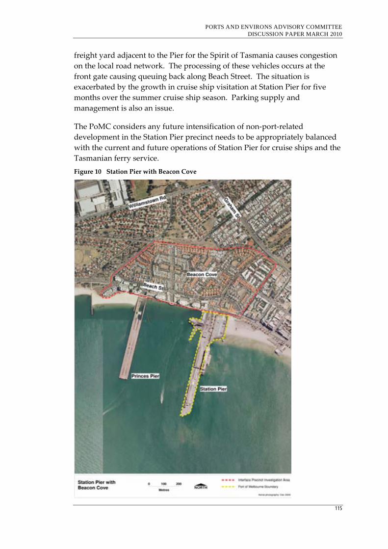
PORTS AND ENVIRONS ADVISORY COMMITTEE DISCUSSION PAPER MARCH 2010
115
freight yard adjacent to the Pier for the Spirit of Tasmania causes congestion
on the local road network. The processing of these vehicles occurs at the
front gate causing queuing back along Beach Street. The situation is
exacerbated by the growth in cruise ship visitation at Station Pier for five
months over the summer cruise ship season. Parking supply and
management is also an issue.
The PoMC considers any future intensification of non‐port‐related
development in the Station Pier precinct needs to be appropriately balanced
with the current and future operations of Station Pier for cruise ships and the
Tasmanian ferry service.
Figure 10 Station Pier with Beacon Cove

PORTS AND ENVIRONS ADVISORY COMMITTEE DISCUSSION PAPER MARCH 2010
116
Advisory Committee discussion
Station Pier is not a ‘built‐for‐purpose’ facility for either the Spirit of
Tasmania or cruise ships, so it is not surprising that there are significant
traffic issues associated with the Pier.
However, the traffic congestion issues are an operational matter for Council
rather than issues that can be addressed through the statutory planning
framework. Accordingly, the Committee considers it does not have a role to
play in addressing such issues.
The Committee also considers that Beacon Cove residents should expect a
high level of activity occurring around Station Pier given its historical role as
Melbourne’s shipping passenger terminal. It would not surprise that some
Beacon Cove residents are attracted to the area for this very reason.
With respect to the PoMC’s comments that future intensification of non‐port‐
related development in this precinct is ‘appropriately balanced’, the
Committee notes that such an expectation appears to conflict with other
planning objectives that has seen the development of Beacon Cove with a
mix of high and medium density dwellings.
Key issue for consideration
How should future intensification of non‐port‐related development in
the Station Pier precinct be appropriately balanced with the current and
future operations of Station Pier for cruise ships and the Tasmanian
ferry service?
7.3.6 Appleton Dock, Victoria Dock and South Wharf with Lorimer Street and Fishermans Bend
Background
Appleton Dock and Victoria Dock are currently used for general cargo and
PoMC proposes to develop these docks in the short to medium term for
international containers.
South Wharf is used for a range of activities, including break bulk and dry
bulk cargoes, bulk cement imports and ancillary services. The PDS does not
propose any changes occurring at this wharf.
Amenity impacts from these parts of the port include air and noise emissions
and light spill.
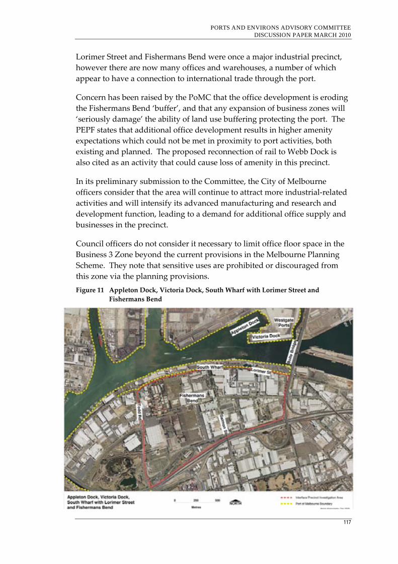
PORTS AND ENVIRONS ADVISORY COMMITTEE DISCUSSION PAPER MARCH 2010
117
Lorimer Street and Fishermans Bend were once a major industrial precinct,
however there are now many offices and warehouses, a number of which
appear to have a connection to international trade through the port.
Concern has been raised by the PoMC that the office development is eroding
the Fishermans Bend ‘buffer’, and that any expansion of business zones will
‘seriously damage’ the ability of land use buffering protecting the port. The
PEPF states that additional office development results in higher amenity
expectations which could not be met in proximity to port activities, both
existing and planned. The proposed reconnection of rail to Webb Dock is
also cited as an activity that could cause loss of amenity in this precinct.
In its preliminary submission to the Committee, the City of Melbourne
officers consider that the area will continue to attract more industrial‐related
activities and will intensify its advanced manufacturing and research and
development function, leading to a demand for additional office supply and
businesses in the precinct.
Council officers do not consider it necessary to limit office floor space in the
Business 3 Zone beyond the current provisions in the Melbourne Planning
Scheme. They note that sensitive uses are prohibited or discouraged from
this zone via the planning provisions.
Figure 11 Appleton Dock, Victoria Dock, South Wharf with Lorimer Street and
Fishermans Bend

PORTS AND ENVIRONS ADVISORY COMMITTEE DISCUSSION PAPER MARCH 2010
118
Advisory Committee discussion
The Committee inspected Appleton Dock, Victoria Dock and South Wharf
and the Lorimer Street and Fishermans Bend precinct and noted the
relatively new office and warehouse development that is occurring in the
area.
In the Committee’s view, such development is improving the built form of
the area and would appear to be providing significant employment
opportunities in accordance with City of Melbourne’s planning objectives to
establish the area as the preferred location for clean, high profile, value‐
added advanced manufacturing. The Advisory Committee notes the
purpose of the Business 3 Zone is To encourage the integrated development of
offices and manufacturing industries and associated commercial and industrial uses.
The Committee does not agree with PoMC’s submission or the PEPF’s
statement that the recent office development is incompatible with current or
future port activities and sees no justification for limiting the floor space of
new buildings or requiring a Design and Development Overlay requiring
buildings to address potential amenity impacts of the port. It notes that,
unlike Coode Island, these parts of the port do not contain major hazard
facilities.
Accordingly, the Committee does not consider the Lorimer Street and
Fishermans Bend precinct need be included in the port environs that should
be subject to any additional planning controls and the requirements for the
notice or referral of applications to the PoMC.
Key issue for consideration
Should Lorimer Street and Fishermans Bend be included in the port
environs given the Business 3 Zone and nature of office and warehouse
development that is occurring in the area?
7.3.7 Victoria Dock with Docklands
Victoria Dock is approximately 21 hectares and the PoMC invested
approximately $10 million in 2002 to prepare the site for future development.
In 2004, the State Government awarded a tender to develop the site to
Westgate Ports.
Westgate Ports is currently developing the site as a freight and logistics
centre, including a 17,500 square metres warehouse with a 50,000 square
metres container hardstand storage area together with a separate 5,400
square metres warehouse.
PORTS AND ENVIRONS ADVISORY COMMITTEE DISCUSSION PAPER MARCH 2010
119
From the 1880s, the Docklands were used for docks, rail infrastructure and
industry but mostly fell out of use following the containerisation of shipping
traffic. The space remained vacant and unused during the 1980s and it fell in
to disrepair.
From the 1990s, a major urban renewal of Melbourne Docklands
commenced, with construction of a moveable roof sports stadium followed
by a number of both commercial and residential high and medium rise
developments.
Docklands is an area extending up to 2 km west of and adjacent to
Melbourneʹs CBD and, according to the 2006 Census, had a population of
3,939.
The brief for the Docklands master plan was for wide open water‐side
promenades and road boulevards with contributions of landscaping and
public art commissions to be made by each developer. It is estimated that the
population of Docklands will reach 20,000 by 2015.
The Victoria Dock and Docklands interface occurs just west of the Bolte
Bridge. It is understood that the Docklands Act 1991 actually includes part of
Victoria Dock east of Bolte Bridge and that, despite the gazettal of this land
as Docklands area, it is owned by the PoMC.
Currently much of the eastern end of Victoria Dock and the outermost
western end of Docklands are undeveloped.
The PEPF states that potential interface issues have been addressed through
the Victoria Dock development assessment process, including a requirement
to assess noise impacts and provide attenuation if required. It further states
that these requirements are complemented with overlay and policy
provisions in the Port of Melbourne Planning Scheme.
It is the PoMC’s understanding that the Docklands area closer to the Bolte
Bridge will include parkland/recreation use, which would reduce potential
adverse amenity impacts from the port.
The PoMC also noted that Docklands has the potential to constrain the Webb
Dock precinct because of concerns of Docklands residents about potential
noise and exhaust emissions, visual impacts, vibrations and boating access.
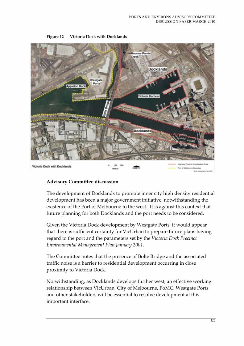
PORTS AND ENVIRONS ADVISORY COMMITTEE DISCUSSION PAPER MARCH 2010
120
Figure 12 Victoria Dock with Docklands
Advisory Committee discussion
The development of Docklands to promote inner city high density residential
development has been a major government initiative, notwithstanding the
existence of the Port of Melbourne to the west. It is against this context that
future planning for both Docklands and the port needs to be considered.
Given the Victoria Dock development by Westgate Ports, it would appear
that there is sufficient certainty for VicUrban to prepare future plans having
regard to the port and the parameters set by the Victoria Dock Precinct
Environmental Management Plan January 2001.
The Committee notes that the presence of Bolte Bridge and the associated
traffic noise is a barrier to residential development occurring in close
proximity to Victoria Dock.
Notwithstanding, as Docklands develops further west, an effective working
relationship between VicUrban, City of Melbourne, PoMC, Westgate Ports
and other stakeholders will be essential to resolve development at this
important interface.
PORTS AND ENVIRONS ADVISORY COMMITTEE DISCUSSION PAPER MARCH 2010
121
Further, any proposal to construct the Webb Dock rail connection through
Docklands will require a collaborative planning approach between PoMC
and VicUrban.
Accordingly, the Committee considers there is strong merit in identifying the
western part of Docklands as a port environs area that should be subject to
additional planning controls particularly relating to siting and design
requirements to reduce the potential impacts of the activities occurring at
Victoria Dock. Notice and referral of applications to the PoMC would also
appear to be appropriate.
Key issues for consideration
Should the western part of Docklands be included in the port environs
and be subject to additional planning controls to take account of the
potential amenity impacts of Victoria Dock?;
Should applications within the port environs be subject to notice or
referral to the PoMC?
Are there other mechanisms that should be developed to ensure an
effective working relationship between VicUrban, City of Melbourne,
PoMC and Westgate Ports as Docklands develops further westwards?
7.3.8 Holden Dock with Francis Street, Yarraville
Background
Holden Dock is used for the storage and transfer of refined petroleum
products. The Port’s PDS states that this dock will be used for bulk liquid
products stored in large tanks for the long‐term.
It is understood there is widespread concern about the potential
environmental and community safety impacts of any incident occurring at
this location. Concern about such incidents was recently highlighted with
the petroleum spill at the Mobil oil refinery in Millers Road, Altona on 9
February 2010.
As well as concern about environmental risk and community safety, there is
significant concern in this precinct in relation to high traffic volumes of
heavy vehicles using Francis Street.
The Committee notes that a Mixed Use Zone applies west of the Holden
Dock precinct on the western side of Hyde Street. This area contains a
number of dwellings.
PORTS AND ENVIRONS ADVISORY COMMITTEE DISCUSSION PAPER MARCH 2010
122
Further, the Committee notes that the Maribyrnong Planning Scheme
includes an objective to encourage the transition in this area from residential
to non‐residential activity in the long term. It is anticipated that this precinct
will be rezoned Industrial 3 in the future.23
PoMC notes that in Spotswood residential development is located in close
proximity to the oil terminals which are connected by pipeline to Holden
Dock. Further, residential development is contrary to the industrial buffer
objectives in Clause 17.03 of the planning scheme and would erode the
ongoing viability of these uses.
23 Clause 22.02-3 of the Maribyrnong Planning Scheme
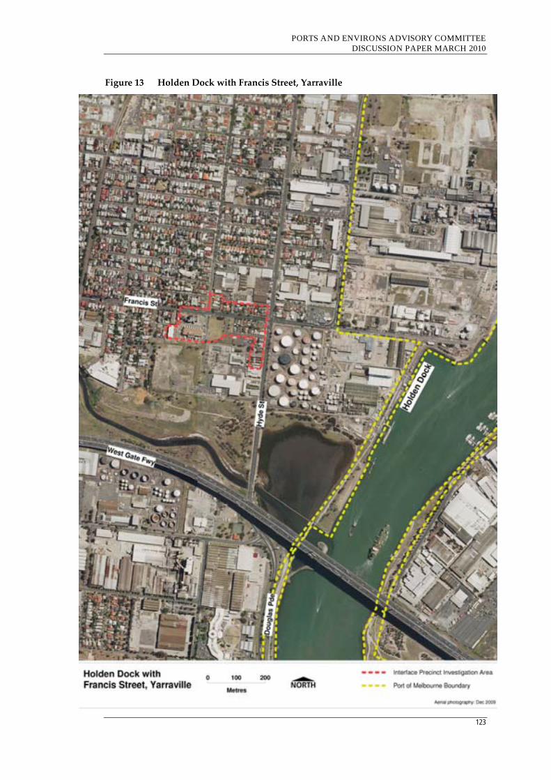
PORTS AND ENVIRONS ADVISORY COMMITTEE DISCUSSION PAPER MARCH 2010
123
Figure 13 Holden Dock with Francis Street, Yarraville

PORTS AND ENVIRONS ADVISORY COMMITTEE DISCUSSION PAPER MARCH 2010
124
Advisory Committee discussion
Given the location of the refined petroleum products in close proximity to
the Mixed Use Zone and the existence of a number of dwellings, this area
should be included in the port environs.
While the Maribyrnong Planning Scheme encourages non‐residential uses in
this area and aims to eventually rezone the land to Industrial 3, it may be
prudent to consider rezoning this land to Industrial 3 in the short‐term.
Rezoning the land to Industrial 3 would be the most effective response to
prohibiting further sensitive uses from encroachment at this interface.
Further, consideration should be given as to whether an overlay should be
introduced that requires development at this interface to take account of the
storage of refined petroleum products as well as to whether notice or referral
of applications to PoMC should occur.
It is understood that there is strong local community concern in relation to
transport and traffic issues in this precinct. In response, VicRoads has
developed the Truck Action Plan which aims to reduce truck traffic on the
residential streets and improve freight access from the west to the Port of
Melbourne. In the Committee’s view, traffic concerns will be more
effectively addressed through such measures than any additional controls in
the statutory planning framework.
Key issues for consideration
Should the Mixed Use Zone applying to the land on the west side of
Hyde Street in the Holden Dock precinct be included in the port
environs?
Should the land zoned Mixed Use be rezoned to Industrial 3 in the
short‐term as the most effective buffer treatment because that zoning
prohibits sensitive uses?
Should an overlay be introduced that requires development to take
account of the storage of refined petroleum products?
Should there be a requirement for the notice or referral of applications
to PoMC?
PORTS AND ENVIRONS ADVISORY COMMITTEE DISCUSSION PAPER MARCH 2010
125
7.3.9 Ann Street Pier, Gellibrand Pier and Breakwater Pier with the former Port Phillip Woollen Mill site
Background
The PDS states that the Ann Street Pier in Williamstown is currently used for
the storage and mooring of marine equipment, such as tugs, barges,
pontoons, workboats and survey vessels and there are no proposed change
to these activities.
The PDS also states that the Gellibrand Pier will be retained for liquid bulk
(crude oil) pack type and Breakwater Pier will be retained to ensure the
security and safety of the adjacent Gellibrand Pier. The crude oil tanks
(Mobil Oil) are a MHF.
It is noted that the Port of Melbourne Planning Scheme includes a notation
on the plan at Clause 21.03 that states Increase capacity for liquid bulk berth.
Breakwater Pier is identified as a strategic port asset for use as a future liquid
bulk berth or for special purposes such as visiting naval ships, vessel lay‐up
and large plant storage.
BAE Systems is located on the north side of Nelson Place between Gellibrand
Pier and Ann Street Pier opposite the former Port Phillip Woollen Mill site.
The PoMC notes that a threshold distance of 300 metres is required between
the site and sensitive land uses. The PoMC considers that future uses
adjacent and opposite Gellibrand Pier need to be carefully considered and
any rezoning of existing industrial land would erode the buffer to more
sensitive land uses.
In its Industrial Land Use Management Strategy 2008, the City of Hobsons Bay
has identified the former Port Phillip Woollen Mill site at the corner of
Nelson Place and Kanowna Street as a ‘strategic redevelopment site’, and has
a preference that it be developed for residential purposes. Accordingly,
Council considers that retention of an industrial zone as proposed in the
PEPF is not appropriate and that measures other than a traditional distance
buffer should be considered.
Council is also concerned that retaining the site in an industrial zone does
not address the interface to existing residential properties to the south and
that leaving the site in an industrial zone may render its use and
development impossible and result in urban blight. However, Council is
concerned with high density residential development of this site and in

PORTS AND ENVIRONS ADVISORY COMMITTEE DISCUSSION PAPER MARCH 2010
126
December 2009 refused to adopt proposed Amendment C75 which would
have facilitated a 12 storey residential development.
At the time of writing, the Committee was informed that the Minister for
Planning has approved Amendment C75 which rezones the Woollen Mill site
to Residential 1 and applied an Environmental Audit Overlay. The Minister
has also appointed an Advisory Committee to provide:
An assessment of the suitability of the proposed redevelopment of the
site;
An assessment of relevant planning issues relating to the proposed
developments; and
An assessment of the planning scheme Design and Development
Overlay and Heritage Overlay, and if necessary, recommendations as to
any changes to the proposed controls.
Figure 14 Ann Street Pier, Gellibrand Pier and Breakwater Pier with former Port Phillip
Woollen Mill (Williamstown)

PORTS AND ENVIRONS ADVISORY COMMITTEE DISCUSSION PAPER MARCH 2010
127
Advisory Committee discussion
Given the interface between the Mobil Oil tanks, the port activities at the
three piers and BAE Systems and the industrial areas on the south side of
Nelson Place that are subject to pressure to rezoning to allow sensitive uses,
it is appropriate to include these areas in the port environs.
While Council has its own strategic planning reasons for supporting a
potential residential development on the former Port Phillip Woollen Mills
site, the Committee has observed that the BAE Systems building fronting
Nelson Place is a substantial building that provides a significant barrier
between the industrial activities occurring behind this building and south of
Nelson Place. In the Committee’s view, this could provide some justification
to allow sensitive uses such as residential development to be considered for
the site. However, the Committee acknowledges there is no obligation of the
site’s owners to retain this building to screen operations.
Any proposal to redevelop the Woollen Mills site for residential purposes
would need to be sited and designed to avoid potential adverse amenity
impacts. Accordingly, the Committee considers that there is a case to be
made for a site‐specific overlay to be introduced for this site that would
specifically address potential impacts from the port area and for a
requirement for notice or referral of applications to the PoMC.
Finally, the Committee notes that the former Woollen Mill site appears to be
just outside the 300 metre buffer distance for petroleum storage under Clause
52.10. If this is the case, this would also provide some justification for a
residential development to be considered.
Key issues for consideration
Should the former Port Phillip Woollen Mills site and other industrial
zoned land south of Nelson Place be included in the port environs?
Is there scope for appropriate residential development to be approved
on the former Port Phillip Woollen Mills site given the substantial
barrier provided by the BAE Systems building and operations to the
north and the distance of the site from the MHF (Mobil Oil tanks)?
Should an overlay to require a design response that would mitigate
potential amenity impacts from the port area be introduced on the
former Port Phillip Woollen Mills site?
Should there be a requirement for the notice or referral of applications
in the current industrial zoned land to the PoMC?
PORTS AND ENVIRONS ADVISORY COMMITTEE DISCUSSION PAPER MARCH 2010
128
7.4 Conclusion
As can be seen from the preceding analysis, there is a variety of land uses
and developments and planning objectives and controls that apply to land at
the different interfaces with the Port of Melbourne. It is because of the
variety of land uses at these interfaces that a site specific response is required
to identifying whether the area under investigation should be included
within the port environs. This response could be additional planning
controls and/or whether applications at these interfaces should be subject to
the notice and referral requirements of Clause 66.10 of the VPPs.
7.5 Port of Hastings
Background
The Port of Hastings is located to the south‐east of Melbourne in the Shire of
Mornington Peninsula. The total amount of land included in the Special Use
Zone 1 (SUZ1) for port‐related purposes is approximately 3,500 hectares.
However, current port and port‐related activities cover a relatively small area
and much of the land in the SUZ1 is currently not used or developed for
port‐related purposes.
The Port of Hastings Land Use and Transport Strategy (PLUTS) identifies three
precincts of the port. The future planning is summarised as follows:
Long Island precinct – will be significantly developed for container and
multi‐purpose trade;
Crib Point ‐ will continue to be used as a liquid berthing facility,
however not all land may be required and scope exists for community,
recreational and environmental uses for this area; and
Stony Point ‐ is expected to become available for community, tourism
and recreational uses, including a continuation of passenger ferry
services and potentially a car ferry service to Phillip Island.
The Port and SUZ1 is surrounded by extensive rural, rural living and public
use land as well as Western Port. In contrast to the Port of Melbourne, the
encroachment of sensitive uses into the port environs has not given rise to
the same level of concern.
Further, the storage of hazardous materials on the former Esso land
accommodating the tanks and the fractionation plant in the Long Island
precinct is located a considerable distance from any sensitive uses including
the Hastings township.
PORTS AND ENVIRONS ADVISORY COMMITTEE DISCUSSION PAPER MARCH 2010
129
The Port of Hastings commissioned a report to review existing development,
land tenure, planning studies and planning provisions to determine the
planning controls required to facilitate Stage 1 of the proposed Long Island
development and recommends a specific zoning control be introduced.24
The Shire of Mornington Peninsula supports the development of the
Hastings Port, however considers there are critical environmental, social and
economic questions which need to be addressed. Local community groups
have also identified the need to protect the sensitive coastal environment.
In terms of the PLUTS, Council notes that it focuses primarily on the land
required for the establishment of a port facility and associated transport
infrastructure, which is in the order of 300 hectares. However,
approximately 3,500 hectares is contained within the SUZ1 zone and the
Strategy does not contain any substantive review of the extent of land
required for port‐related purposes and the appropriate boundaries.
Accordingly, Council considers that it would be inappropriate to apply the
proposed zone for the Long Island precinct as a replacement for the SUZ1
that currently applies over all the port purposes land. In addition, Council
considers the transfer of planning authority to a specialist port agency would
risk a less balanced approach to decision‐making.
Advisory Committee discussion
The major challenge for the Port of Hastings will be to develop as
Melbourne’s second commercial trading port in a manner that will result in
appropriate co‐existence with surrounding and adjoining land uses,
including the internationally significant coastal environs.
A further challenge will be to develop the road and rail linkages and ensure
these corridors will not have an unreasonable adverse impact on adjoining
residential areas and sensitive uses. It may be appropriate for relevant
authorities to investigate applying a DDO along these transport corridors to
protect sensitive uses similar to DDO1 in the Hume Planning Scheme.
Given that the Port of Hastings is largely undeveloped, there is a significant
opportunity to ensure that land identified for port and port‐related
development areas currently in the SUZ1 are planned to adequately address
amenity and risk impacts. In the Committee’s view, this will require a
collaborative approach involving relevant stakeholders including the port
24 Port of Hastings Stage One Scoping Land Use Planning Assessment Review, AECOM, June 2009
PORTS AND ENVIRONS ADVISORY COMMITTEE DISCUSSION PAPER MARCH 2010
130
manager, relevant government departments and agencies, Council and the
local community.
The Committee supports Council officers’ comments that it would be
appropriate for the port authority to undertake a review as to whether the
3,500 hectares of land will be necessary in the long‐term for port and port‐
related uses. The Committee notes that total land area of Port of Melbourne
Port is approximately 510 hectares.
At this stage, the Committee does not consider there is a need to identify any
port environs areas that require an interface treatment. However, interface
issues will need to be an integral element of further planning and
development.
Responses to other issues raised by Council concerning the zoning of the
land and the role of the Minister for Planning are made in Chapters 11 and 12
in this report.
Key issues for consideration
Is there a need for a study that reviews the extent and boundaries of
land for port and port‐related purposes before the port environs can be
identified?
Should there be an investigation whether a DDO along the proposed
transport corridors to the Port of Hastings similar to the DDO1 in the
Hume Planning Scheme be undertaken to protect sensitive uses along
these transport corridors?
7.6 Port of Geelong
The Port of Geelong has a number of sensitive interfaces, including:
North Shore residential area with Incitec Pivot and Midway;
Norlane residential area with industrial land east of Station Street;
Former Ford site with ‘port area of interest’ land;
Proposed Geelong marine industrial project, Osborne Park, Osborne
House, and the Rippleside residential area with ‘port area of interest’
land; and
Geelong Grammar School with Shell Refinery.
While the Point Henry Alcoa aluminium smelter is also identified as part of
the ‘port area of interest’, the Port of Geelong Land Use Strategy (PLUS) does
not identify any interface issues between Point Henry and surrounding

PORTS AND ENVIRONS ADVISORY COMMITTEE DISCUSSION PAPER MARCH 2010
131
areas. The Committee agrees with this view given that the interface areas are
Cheetham Salt Works and land within the Farming Zone.
As noted in Section 5.4.7, the Committee considers that the Geelong Port
Structure Plan prepared by Greater Geelong City Council has provided a
useful framework which has assisted the Committee identify the key
interface issues at this port.
7.6.1 North Shore residential area with Incitec Pivot and Midway
Background
North Shore is a long‐established residential enclave of about 200 dwellings
within the ‘port area of interest’ and has two major industrial neighbours ‐
Incitec Pivot to the north and Midway to the south. Incitec Pivot stores and
mixes fertilisers and it is understood that the company ceases operations
when there is an easterly breeze to prevent emissions blowing over North
Shore. Midway operates a woodchip facility.
Both GeelongPort and the City of Greater Geelong readily concede that a
residential development in such close proximity to a major port would not be
contemplated under contemporary planning practice. However, both parties
also concede that North Shore is a well‐established residential area and
highly sought after given its location to the Geelong CBD and views across
Corio Bay to the Geelong CBD skyline. There are no proposals to rezone
North Shore from its current residential zoning.
On its tour of the port and surrounding areas, the Committee observed that
North Shore contains a mix of older dwellings and more recent medium
density housing developments.
The PLUS recommends a specific local plan be developed to protect local
amenity for North Shore.
Council’s Geelong Port Structure Plan includes a number of suggestions to
address the impacts of the port and port‐related activities on North Shore,
including:
Discourage further development of privately owned sites on the south
side of Sea Breeze Parade, and Incitec Pivot purchase the remaining
dwellings to augment the role of the buffer;
Maintain and enhance the Incitec Pivot landscape buffer on the south
side of Sea Breeze Parade;

PORTS AND ENVIRONS ADVISORY COMMITTEE DISCUSSION PAPER MARCH 2010
132
Maintain a low intensity housing development acknowledging the
ongoing incompatibility between industrial and residential uses; and
Work with the North Shore community in partnership with relevant
government departments and agencies and GeelongPort to develop a
comprehensive buffer strategy and development plan for the North
Shore residential area.
GeelongPort advised that there is a North Shore community reference group,
which provides an opportunity to raise issues of mutual concern.
The North Shore Residents Group advised that it has a good working
relationship with GeelongPort. The Group accepts that residents should not
expect the same level of amenity that would be appropriate in greenfield
situations. It considers there are opportunities to acquire land and establish
land buffers on the fringes of the residential area. The Group also considers
there should be no high rise residential development that could result in
increased conflict between the port and future residents. The Group also
noted that the construction of the ‘port bypass’ road has been significant in
reducing amenity and safety concerns.
Figure 15 North Shore with Port of Geelong Area of Interest Land

PORTS AND ENVIRONS ADVISORY COMMITTEE DISCUSSION PAPER MARCH 2010
133
Advisory Committee discussion
Given the location of North Shore between the northern and southern
precincts of the general port area, it has a direct interface and should be
included in the port environs area.
The most sensitive interface is to the north at Sea Breeze Parade. This road
appears to carry significant volumes of heavy vehicle traffic that access the
Incitec Pivot plant which is located on the north side of this road.
To reduce the adverse impacts of its operations on North Shore, it is
understood that Incitec Pivot have purchased all but one of the residential
allotments on the south side of Sea Breeze Parade and that it has removed all
the houses except one. Accordingly, there are only two houses remaining on
this side of the street.
It would appear there is an opportunity to formalise this landscape buffer by
introducing a planning control that would prohibit any further development
and by creating a landscape plan that would provide more effective
buffering to the residential properties to the south.
Development could be prohibited by introducing an alternative zone such as
Public Park and Recreation Zone or by preparing a site specific control under
Clause 52.03 of the VPPs. There is no overlay control in the VPPs that would
prohibit all development.
An alternative option could be to encourage a development on the south side
of Sea Breeze Parade that would provide a built form element reducing the
amenity impacts to the south. However, any such development would be
constrained by the residential zoning that currently applies to the land.
There may also be opportunities for more substantial landscaping on the
north side of Sea Breeze Parade within the Incitec Pivot site.
In addition to these measures, the Committee notes that strong potential
exists for future development to occur in the area. As a result, it may be
appropriate for additional planning controls to apply in North Shore which
limits further intensification of residential development and height of
development. This could be achieved by preparing a purpose‐specific
overlay.
Consideration should also be given to requiring applications for use and
development to be subject to notice and referral to GeelongPort as a means
for the port manager to keep abreast of developments and ensure their views
are considered.
PORTS AND ENVIRONS ADVISORY COMMITTEE DISCUSSION PAPER MARCH 2010
134
Key issues for consideration
Should North Shore be included in the port environs?
Should a planning control be introduced which prohibits any further
development on the residential zoned land on the south side of Sea
Breeze Parade?
Should a development on the south side of Sea Breeze Parade be
encouraged to provide a built form element to protect the amenity of
the area to the south?
Should a more detailed landscape plan be prepared and implemented
which provides better protection of the residential area to the south?
Should a planning control be introduced which limits the density and
height of residential development in North Shore?
Should applications for use and development be subject to the notice
and referral requirements to GeelongPort pursuant to Clause 66.10 of
the VPPs?
7.6.2 Norlane residential area with the industrial area east of Station Street
Background
Norlane is a long‐established residential area located to the north and west of
the port. Norlane’s housing was mainly constructed for workers of the port
and industrial areas of Geelong, including Ford, in the 1950s and 1960s.
Norlane is separated from an industrial area to the west by Station Street.
While this industrial area is included in ‘port area of interest area’ in the
PLUS and within the Geelong Port Structure Plan area prepared by Council,
the Committee notes it is a considerable distance from the core port activities
occurring closer to the foreshore.
The PLUS notes that while the Shell Refinery and Terminals Pty Ltd have
substantial buffers, they remain a concern to members of the Norlane
community. It further notes that new land use proposals within the ‘port
area of interest’ can present interface issues. It is also suggested that siting
and design guidelines may be appropriate for industrial development at the
interface.
Council’s Geelong Port Structure Plan includes a general objective to reduce
the amenity conflicts between existing industrial and port uses and nearby
residential areas.

PORTS AND ENVIRONS ADVISORY COMMITTEE DISCUSSION PAPER MARCH 2010
135
In addition, there is a notation on the Lascelles precinct plan that states that
the land between Station Street and the Melbourne‐Geelong railway line
should be rezoned from Industrial 2 to Industrial 3 as part of the Norlane
Redevelopment Project.25
The Geelong Port Structure Plan states that the Port of Geelong includes the
use, storage and manufacture of products that have health and safety
impacts on the local community. The Structure Plan includes two principles
to manage this issue, namely:
· To promote the growth and development of Geelong Port that
supports the health and wellbeing of the Geelong community,
consistent with the principles of Council’s Strategic Health Plan.
· To ensure future use and development within core Port industry and
Port use areas require the preparation and maintenance of plans to
appropriately manage risks from off site impacts to the local
community and environment.
Presentations by representatives of the Community for Good Life and
Geelong Environment Council were made to the Committee regarding the
potential health impacts associated with the storage of petroleum, fertilisers
and chemicals, particularly butadiene, at the Port of Geelong.
Figure 16 Norlane with Industrial Area to the West
25 It is understood that the project referred to in the Structure Plan is the Norlane and Corio Urban
Renewal Project.
PORTS AND ENVIRONS ADVISORY COMMITTEE DISCUSSION PAPER MARCH 2010
136
Advisory Committee discussion
There is a considerable distance between the main port activities near or at
the foreshore and the Norlane residential area. However, there is a direct
interface between the industrial zoned area on the east side of Station Street
and the residential area on the west side.
From the Committee’s observations, a number of the industrial lots on the
east side of Station Street are vacant and many of the industries appear to be
local service industries that have little or no connection with the port.
The Committee notes that the Greater Geelong Planning Scheme already
includes this industrial zoned land in DDO20, which requires all
development to comply with design objectives relating to visual appearance,
amenity, setbacks, architectural interest and landscaping. These
requirements address potential amenity impacts from industrial
developments, whether or not they are associated with the port.
The Committee considers Council’s recommendation that the land between
Station Street and the Melbourne‐Geelong railway line be rezoned to
Industrial 3 is an appropriate response to address the interface with Norlane.
Should the Committee’s recommendation that a Port Zone be introduced for
the ports be supported, a schedule could be developed for application in this
area that that could restrict uses similar to the Industrial 3 zone.
In the Committee’s view, the proposal to rezone the land between Station
Street and the Melbourne‐Geelong Railway Line to Industrial 3 and the
existing requirements in DDO20 provide an appropriate treatment at this
interface and that further planning tools are not required to protect Norlane.
The Committee also sees little benefit in identifying Norlane as a port
environs area in order to protect the port or industrial area from the
encroachment of sensitive uses. Norlane is a long‐established area, and
while it is subject to a State Government urban renewal project, it is unlikely
to go through substantial change in terms of intensification of residential
development or high‐rise built form.
In response to the concerns about health impacts of hazardous materials at
the Port of Geelong, the Committee believes its role is limited to considering
the threshold distances in Clause 52.10 of the VPPs in order to determine the
port environs. The Committee does not consider it has a role in assessing the
adequacy of the threshold distances, the performance of these industries or
the performance of the EPA and other agencies in assessing the performance
of the industries.

PORTS AND ENVIRONS ADVISORY COMMITTEE DISCUSSION PAPER MARCH 2010
137
Key issues for consideration
Would the proposal to rezone the land between Station Street and the
Melbourne‐Geelong Railway Line from Industrial 2 to Industrial 3 as
well as the existing DDO20 that requires new industrial development to
address potential amenity impacts provide an adequate interface
treatment to Norlane?
Should Norlane, particularly the properties on the west side of Station
Street, be included in the port environs in order to protect the port and
industrial areas from the encroachment of sensitive uses?
7.6.3 Former Ford site with ‘port area of interest’ land
Background
The former Ford site is located south of the existing Ford site fronting Princes
Highway, to the west of the ‘port area of interest’ land.
In 2006 an Amendment to rezone the site from Industrial 1 to
Comprehensive Development Zone (CDZ) was proposed to facilitate a bulky
goods retail development. The Amendment was strongly opposed by
GeelongPort. The Amendment was referred to a Panel that recommended it
be abandoned for a number of reasons including that the site should be seen
as an opportunity for further development of the port.
With respect to the site’s location to the port, the Panel found that:26
The Port of Geelong is major infrastructure of State significance. The
Greater Geelong Planning Scheme recognises this. The Planning
Scheme also recognises opportunities for retail growth and development,
but these should not compromise higher order objectives. The Panel
considers the clear objectives about the port are of a higher order and
should remain so.
GeelongPort consider the Amendment would have eroded the land that is
available for port‐related uses potentially constraining growth and current
operations.
The Department of Innovation, Industry and Regional Development (DIIRD)
also expressed a concern that the loss of the former Ford site from a port‐
related use would have an adverse economic outcome, because it would be a
lost opportunity for a major firm to establish an efficient supply chain
management system.
26 Greater Geelong Planning Scheme Amendment C98 Panel Report, page 5
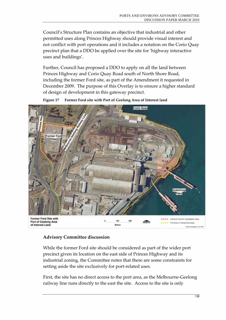
PORTS AND ENVIRONS ADVISORY COMMITTEE DISCUSSION PAPER MARCH 2010
138
Council’s Structure Plan contains an objective that industrial and other
permitted uses along Princes Highway should provide visual interest and
not conflict with port operations and it includes a notation on the Corio Quay
precinct plan that a DDO be applied over the site for ‘highway interactive
uses and buildings’.
Further, Council has proposed a DDO to apply on all the land between
Princes Highway and Corio Quay Road south of North Shore Road,
including the former Ford site, as part of the Amendment it requested in
December 2009. The purpose of this Overlay is to ensure a higher standard
of design of development in this gateway precinct.
Figure 17 Former Ford site with Port of Geelong Area of Interest land
Advisory Committee discussion
While the former Ford site should be considered as part of the wider port
precinct given its location on the east side of Princes Highway and its
industrial zoning, the Committee notes that there are some constraints for
setting aside the site exclusively for port‐related uses.
First, the site has no direct access to the port area, as the Melbourne‐Geelong
railway line runs directly to the east the site. Access to the site is only
PORTS AND ENVIRONS ADVISORY COMMITTEE DISCUSSION PAPER MARCH 2010
139
available from Princes Highway. Any infrastructure to connect the site to the
other side of the railway line would be at a considerable cost.27
Second, in response to DIIRD’s concern about the economic importance of
establishing port‐related uses near the port, the Committee observes that
there is a significant amount of vacant and under utilised land in the port
area that could be developed for port‐related uses, including land closer to
the dock areas.
Notwithstanding these concerns, the Committee notes the very strong views
expressed by GeelongPort and DIIRD about retaining the site in the port
environs, and that Council’s key concern is not about the use of the site but
about the quality of the development.
Key issue for consideration
Should the former Ford site be confined to a port‐related use and
continue to be identified within the ‘port area of interest’ given the
site’s gateway location into Geelong and the lack of direct access to the
port area?
7.6.4 Proposed Geelong marine industry project, Osborne Park, Osborne House, and the Rippleside residential area with ‘port area of interest’ land
Background
The proposed Geelong marine industry project is to be located on the former
power station site, located within the wider port area south of the GrainCorp
site. This project proposes to offer facilities for boat‐manufacturing,
maintenance and repairs, storage and slip/lift facilities.
Further south is Osborne Park which contains Osborne House, a Victorian
era homestead currently occupied by the Geelong Maritime Museum. South
of Osborne Park is the Rippleside residential area.
The PLUS states that the proposed Geelong marine industry project is a
suitable land use transition between the port and the residential area to the
south, however it also states that the existing industrial zone applying to the
site should be retained.
27 It is noted that the Greater Geelong Planning Scheme Amendment C98 Panel Report referred to a
Connell Wagner report that estimated that the cost of a two lane bridge was $2.5m.
PORTS AND ENVIRONS ADVISORY COMMITTEE DISCUSSION PAPER MARCH 2010
140
GeelongPort is concerned that any potential tourist accommodation within
the marine industry project would be an encroachment of a sensitive use,
and that may affect what could occur on port‐related land.
Others stakeholders including the Victorian Regional Channel Authority and
DIIRD also questioned the wisdom of allowing accommodation in the
marine industry project.
Council’s Structure Plan acknowledges the need to address the interface
between the port and surrounding area, and recommends that:
Applying a Special Use Zone to the marine industry project and
Osborne Park to provide an appropriate interface to ensure future use
and development does not detrimentally affect the port;
Retention of existing industrial zones in Mackey Street;
Ensuring the entire 300 metre Barrett Burston buffer is within an
industrial zone (involves extending IN1 south by approximately 12
metres); and
Limiting residential/accommodation use to Osborne House, and
ensuring design of accommodation components consider potential
impacts from the port and port‐related activities.

PORTS AND ENVIRONS ADVISORY COMMITTEE DISCUSSION PAPER MARCH 2010
141
Figure 18 Marine Industry Project and Ripponlea with Port of Geelong Port Area of
Interest land
PORTS AND ENVIRONS ADVISORY COMMITTEE DISCUSSION PAPER MARCH 2010
142
Advisory Committee discussion
Other than the concern with proposing tourist accommodation in the
proposed marine industry project, it appears that GeelongPort considers the
project would be an acceptable land use transition between the port area and
non‐port uses.
In response to GeelongPort’s comment that it may be appropriate to retain an
industrial zone over the proposed project site, the Committee considers that
such a zone may be too restrictive and that either the proposed Port Zone
with an appropriate schedule or a Special Use Zone specifically tailored for
the development would be more appropriate.
The Committee does not have a major concern with promoting tourist, short‐
term accommodation in the proposed development on the basis that such
accommodation does not generate the same amenity expectations associated
with permanent accommodation.
Key issues for consideration
Is the proposed Geelong marine industry project a suitable land use
transition between the Port and other uses?
Should the proposed Geelong marine industry project site be retained
within the Industrial 1 Zone, or rezoned to the proposed Port Zone with
an appropriate schedule or rezoned to a specifically tailored Special Use
Zone?
Should tourist accommodation be prohibited within the marine
industry project to ensure there is no impact on the port or port‐related
uses?
7.6.5 Geelong Grammar School with ‘port area of interest land’
Background
Geelong Grammar School is located to the immediate north of the port area
that is currently zoned Industrial 2.
The PLUS does not make any specific recommendations about the interface
with the school. However, there are general recommendations about
retaining all industrial zoned land within the ‘port area of interest’.
Council’s Geelong Port Structure Plan contains an objective that any
applications for use and development in the Refinery Pier precinct should be
assessed having particular regard to nearby sensitive land uses, including the
PORTS AND ENVIRONS ADVISORY COMMITTEE DISCUSSION PAPER MARCH 2010
143
school. The Structure Plan also includes a notation on a map “to maintain
visual and amenity between Shell and Geelong Grammar”.28
It is also recommended that the school site should be rezoned from Farming
to Special Use to better identify and clarify the sensitive use of this land.
Geelong Grammar representatives advised the Committee that the existing
buffer area between Shell Refinery and the school was an important
mechanism to provide a safe environment for its students. They considered
there could be an improvement to the traffic management of the area, and
that more investment on rail would be an important contributor to reducing
potential conflict between port‐related traffic and school generated traffic.
They also preferred Council to remain the responsible authority for the Port
of Geelong because they considered Council would be more likely to give
greater weight to local issues.
28 Refer to Map 2, page 18
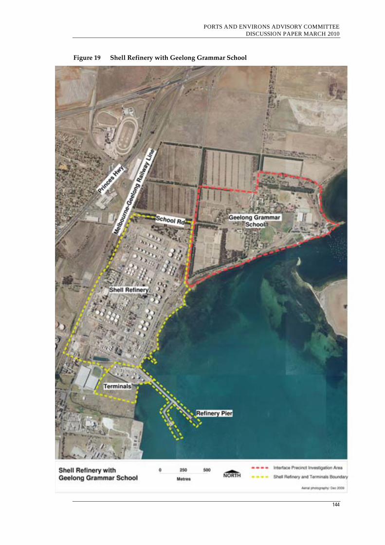
PORTS AND ENVIRONS ADVISORY COMMITTEE DISCUSSION PAPER MARCH 2010
144
Figure 19 Shell Refinery with Geelong Grammar School

PORTS AND ENVIRONS ADVISORY COMMITTEE DISCUSSION PAPER MARCH 2010
145
Advisory Committee discussion
Given the School’s location near the port, the school site should be included
in the port environs. On this basis it should be subject to a planning control
to ensure future use and development does not have an impact on the port
and port‐related activities, and that applications for use and development are
subject to notice and referral to GeelongPort.
However, the Committee notes that the school is well aware of the existence
of the port and does not propose to construct new buildings closer to the
port.
Instead of an additional planning control, an appropriate course of action
could be for the school to prepare a master plan for the site and for it to be
incorporated into the planning scheme. With such an approach, all parties
including the GeelongPort and other port stakeholders such as Shell would
have a very clear understanding of the future development of the school site.
Any significant variation to develop outside the parameters of the master
plan would trigger a planning scheme amendment and public notice.
It may also be appropriate that the school consider applying for a Special Use
Zone as an outcome of a master plan for the site.
Key issues for consideration
Should Geelong Grammar School be included in the port environs?
Should a planning control be introduced to ensure future use and
development on the school site does not have an impact on the port and
port‐related activities?
Should applications for use and development on the school site be
subject to notice and referral to GeelongPort?
Should the school be encouraged to develop a master plan involving
stakeholders including GeelongPort and Shell for the site that could be
incorporated into the Greater Geelong Planning Scheme?

PORTS AND ENVIRONS ADVISORY COMMITTEE DISCUSSION PAPER MARCH 2010
146
7.7 Port of Portland
Background
The Port of Portland has one main sensitive interface, which is the residential
land to the south of the main port area and west of Incitec Pivot.
This interface features a steep escarpment that would reduce some adverse
amenity impacts of port activities on the residents.
Main adverse amenity impacts from the port are noise, dust, odour and light
spill. Problems of odour have occurred from the Incitec Pivot site, and there
is a requirement of the EPA Works Approval for the plant to be closed when
there is an easterly breeze.
In 2008, the Minister for Planning approved Amendment C39 that facilitated
expansion of the woodchip storage and handling facilities at the port. The
Amendment was approved subject to an Environmental Management Plan
being incorporated into the Glenelg Planning Scheme which contains
requirements relating to construction noise and vibration, road traffic noise,
operational noise, air emissions and traffic.
There are also concerns with the impact of port‐related traffic noise on
residential properties, particularly along the Ring Road and Madeira Packet
Road which both serve as major transport corridors to the port. The Port of
Portland expressed strong concerns that any restrictions on the transport
corridors to the port could have a significant impact on the port’s potential to
grow.
Some of the Port’s concerns were addressed with the rezoning of parcels of
land from residential to industrial near Madeira Packet Road with the
approval of Amendment C40 in May 2009.
The PLUS does not contain any specific recommendations to address the
interface between the port and the residential area to the south. However, it
is recommended that the port manager implement an internal review process
to ensure that land use changes within the port consider potential impacts on
adjoining land uses. It is also recommended that the port manager should
work with Glenelg Shire Council and DOT to prepare a detailed buffer
strategy to address interface issues between the port and adjoining land uses.
Council considers that scope exists at the port to mitigate adverse amenity
impacts, and supports the proposal for a detailed buffer strategy.
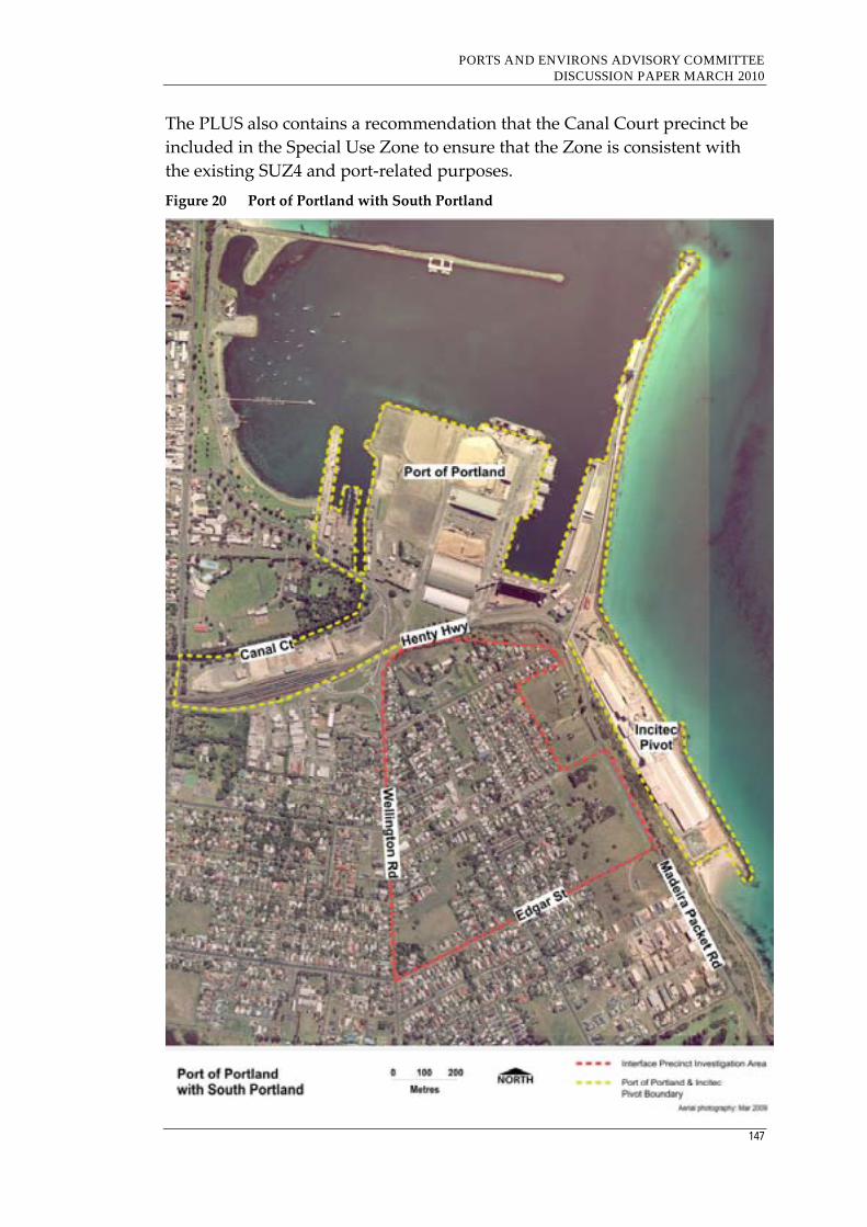
PORTS AND ENVIRONS ADVISORY COMMITTEE DISCUSSION PAPER MARCH 2010
147
The PLUS also contains a recommendation that the Canal Court precinct be
included in the Special Use Zone to ensure that the Zone is consistent with
the existing SUZ4 and port‐related purposes.
Figure 20 Port of Portland with South Portland
PORTS AND ENVIRONS ADVISORY COMMITTEE DISCUSSION PAPER MARCH 2010
148
Advisory Committee discussion
The Committee agrees that the residential area south of the port and east of
Incitec Pivot should be included in the port environs. This area includes land
bound by Henty Highway to the north, Madeira Packet Road to the east,
Wellington Road to the west and Edgar Street to the south.
Given the size of this area and the potential for further development, the
Committee considers there is merit in introducing a planning control that
requires development to be sited and designed to reduce potential amenity
impacts from the port and Incitec Pivot and for applications to be subject to
the notice or referral requirements of Clause 66.10.
The Committee agrees with the Port of Portland’s comments that restrictions
on the use of Ring Road and Madeira Packet Road as a result of concerns
raised by residents regarding traffic noise could have a significant impact on
the port’s growth opportunities. Accordingly, the Committee considers that
an overlay that required new development to be sited and designed to
reduce the impact of traffic noise similar to the DDO1 in the Hume Planning
Scheme is worthy of investigation.
Given the port manager owns Canal Court and it is identified in the PLUS as
required for port‐related uses, it would appear appropriate that it be
considered for inclusion within the port area and subject to the proposed
Port Zone recommended by this Committee.
Key issues for further consideration
Should the residential area to the south of the port and east of Incitec
Pivot and bounded by Henty Highway to the north, Madeira Packet
Road to the east, Wellington Road to the west and Edgar Road to the
south be included in the port environs?
Should a planning control that requires development to be sited and
designed to reduce potential amenity impacts from the port be
introduced?
Should applications for use and development be subject to the notice or
referral requirements of Clause 66?
Should Canal Court be included in the proposed Port Zone
recommended by the Committee?
Should an overlay along the main transport corridors adjacent to
residential areas be introduced to require development to be sited and
designed to reduce the impact of traffic noise?

PORTS AND ENVIRONS ADVISORY COMMITTEE DISCUSSION PAPER MARCH 2010
149
Part D – Planning Framework
PORTS AND ENVIRONS ADVISORY COMMITTEE DISCUSSION PAPER MARCH 2010
150
8. State Planning Policy Framework
8.1 Introduction
The terms of reference require the Advisory Committee to:
Make recommendations that would protect the ports from the
encroachment of sensitive uses through the use of appropriate planning
policy and applications of the Victoria Planning Provisions (Advisory
Committee emphasis)
The starting point for assessing any planning proposal is to determine
whether or not that proposal can be justified strategically. In making any
assessment the overriding strategic context is found in the State Planning
Policy Framework (SPPF) which is common to all planning schemes in
Victoria. It is this section of the planning scheme which sets out relevant
policies of the State. The SPPF provides for ports specifically under Clause
12.04‐2 Transport and freight and Clause 18 Infrastructure.
Under Clause 12.04‐2, ports are referred to where it is stated that key
transport and freight links are encouraged to develop as the nation’s premier
logistics centre through protecting options for access to, and future
development at ports and by ensuring port areas are protected by adequate
buffers to minimize land‐use conflict.
Clause 18 deals with a range of infrastructure items including (in order):
Declared highways, railways and tramways;
Car parking and public transport access to development;
Bicycle transport;
Airfields;
Ports;
Health facilities;
Education facilities;
Survey infrastructure;
Water supply, sewerage and drainage;
Waste management;
High pressure pipelines;
Developer contributions to infrastructure; and
PORTS AND ENVIRONS ADVISORY COMMITTEE DISCUSSION PAPER MARCH 2010
151
Telecommunications.
Within this Clause sub‐clause 18.05 Ports has two objectives as follows:
· To recognise the importance to Victoria of economically sustainable
major ports (Melbourne, Geelong, Portland, Hastings) by planning
for appropriate access, terminal areas and depot areas.
· To plan the land resources adjacent to ports to facilitate the efficient
operation of the port and port‐related uses and minimise adverse
impacts on surrounding urban development and the environment.
In addition Melbourne 2030, a reference document in the SPPF, proposed the
strengthening of the State’s ports as one of its key initiatives and it noted that
the ports and their associated rail and road networks are crucial elements of
the State’s competitive capability.
In this regard Initiative 4.3.2 stated:
Protect options for access to, and future development at, the ports of
Melbourne, Geelong and Hastings, and ensure all port areas are
protected by adequate buffer areas to prevent land‐use conflicts at the
perimeter. *
*Portland was beyond the scope of Melbourne 2030.
Melbourne 2030 clearly recognized the importance of the ports as key drivers
of the State’s economy and the role they play in shaping the State and
national freight networks. Ports handle over 99% of Victoria’s international
import and export trade valued at over $100 billion annually and they
contribute 15,000 direct jobs.
Despite the general support given to port development and buffer
requirements in the SPPF, the PEPF called for the SPPF to be strengthened to
give greater support to the two way amenity impacts for development in
areas close to the port. In this regard it recommended the SPPF provide:
· policy statements that identify the need to apply a two way approach
to managing land use change within the port and its environs, with
the aim of protecting existing and future port operations and the
safety, amenity and environmental qualities of surrounding
communities; and
· policies that seek to protect the port from encroachment from
residential and other sensitive uses by expanding the scope to cover
commercial development and other inappropriate land uses for which
amenity expectations cannot necessarily be met in the port environs.

PORTS AND ENVIRONS ADVISORY COMMITTEE DISCUSSION PAPER MARCH 2010
152
8.2 Advisory Committee discussion
While ports are a strategically vital element of the State’s infrastructure, the
Committee believes that their importance to the State’s economy, as well as
that of the nation and the local areas within which the ports are located,
appears somewhat understated in the SPPF. Ports are referred to in a clause
dealing with matters of lesser significance to the State such as car parking,
bicycle transport and developer contributions. Further, reference to port
access and buffering under a separate and less transparent clause has the
impact of diffusing important policy which would be given greater impact if
placed under a specific clause relating to ports.
The first objective in Cause 18.05 begs the question ‘What is the importance
of the ports to Victoria?’ The Advisory Committee can see no reason why
Clause 18.05 could not be expanded upon to give context to this objective.
The Committee notes that the VPPs require statements of environmental
significance when controlling land that is of environmental importance.
However, no such statements exist where land is of economic significance
other than paragraphs that might be hidden away in a Municipal Strategic
Statement (or Port Strategic Statement in the case of the Port of Melbourne).
The second objective in Clause 18.05, while under the heading of ports, refers
to planning for land adjacent to ports. This raises the question ‘Why would a
responsible authority making a decision on land adjacent to a port refer to a
provision in its planning scheme relating to ports?’
The Advisory Committee has noted that a current departmental review has
led to the release of a revised version of the SPPF for discussion purposes.
The revision has modified the existing arrangement of Clauses which have
an ‘objective’ followed by ‘general implementation’ and ‘geographic
strategies’ sub‐clauses to have an ‘objective‘ followed by ‘strategies’ and
‘policy guidelines’ sub‐clauses.
This revision has placed all policy relating to ports in a revised Clause 18.06
Transport. In the Committee’s opinion ports in this revised SPPF are now
coupled more appropriately with Integrated transport, Movement networks,
Airfields and Freight.
In this version of the SPPF the two existing objectives have been split with
the result that a new Clause 18.06‐1 relates to planning for ports and a new
Clause 18.6‐2 relates to planning for land adjoining ports. Being a ‘policy‐
neutral’ revision, the wording of the objectives has not changed and the

PORTS AND ENVIRONS ADVISORY COMMITTEE DISCUSSION PAPER MARCH 2010
153
strategies under each sub‐clause simply replace what is currently found in
the SPPF.
However the revised SPPF provisions appear more logically formatted and
by splitting the objectives and creating the specific sub‐clause 18.06‐2
Planning for land adjoining ports, they give slightly enhanced emphasis and
transparency to the need for decisions regarding land adjoining ports to take
into account possible impacts on port activities.
The existing Clause 18.05‐2 General implementation states:
The land resources adjacent to ports should be protected to preserve their
value for uses which depend upon or gain significant economic advantage
from proximity to the ports’ particular shipping operations.
Port and industrial development should be physically separated from
sensitive urban development by the establishment of appropriate buffers
which reduce the impact of vibration, intrusive lighting, noise and air
emissions from port activities.
Planning for the use of land adjacent to ports should aim to achieve and
maintain a high standard of environmental quality, be integrated with
policies for the protection of the environment generally and of marine
environments in particular and take into account planning for adjacent
areas and the relevant catchment.
In the Committee’s opinion, this clause does not articulate the possibility of
uses which legitimately seek proximity to a port such as offices and
warehouses (and supporting uses such as restaurants and cafes) may
inappropriately place concentrations of people in areas where there is the
potential for exposure to risk and/or amenity impacts. Such uses, if
permitted in port environs/interface areas, may give rise to pressures to
curtail or restrict port use or port development proposals. The Committee
believes that there are mutual obligations if ports and the surrounding land
uses are to successfully co‐exist and reflect the strategic importance of ports.
The revised SPPF embraces the above ‘general implementation’ provisions
and includes them under an expanded section headed ‘strategies’. This
expanded section draws some related provisions from elsewhere in the SPPF
and is suggested to be worded as follows:
Protect the land resources adjacent to ports to preserve their value for uses
which depend upon or gain significant economic advantage from proximity to
the ports’ particular shipping operations [18.05‐2].

PORTS AND ENVIRONS ADVISORY COMMITTEE DISCUSSION PAPER MARCH 2010
154
Physically separate port and industrial development from sensitive urban
development by the establishment of appropriate buffers which reduce the
impact of vibration, intrusive lighting, noise and air emissions from port
activities [18.05‐2].
Identify and protect options for access to, and future development at, the
ports of Melbourne, Geelong and Hastings [12.04‐2].
Ensure port areas are protected by adequate buffers to minimise land‐use
conflict [12.04‐2].
Improve rail freight access to ports [12.04‐2].
Ensure that planning and development of the Fishermans Bend precinct does
not jeopardise the needs of the Port of Melbourne as a working port and as
one of the State’s most important transport gateways [12.04‐2].
Retain the Port of Hastings as a long‐term option for future port development
should the ports of Melbourne and Geelong no longer meet the State’s needs
[12.04‐2].
(Note: The existing SPPF origin of the various sub‐clauses is shown in brackets.)
Finally, the Committee notes that the only documents listed as references in
the current Clause 18.05‐3 Geographic strategies are Statement of Planning
Policy No 1 ‐ Western Port (1970‐varied 1976) and the Hastings Port Industrial
Area Land Use Structure Plan (Department of Planning and Development 1996).
These references are retained in the revised SPPF under the heading ‘Policy
guidelines’.
Nowhere is there reference to each port’s Port Land Use Strategy prepared
under the Port Services Act 1995 nor important State Government strategies
such as Melbourne @ 5 Million, Victorian Ports Strategic Framework (2004), Port
Futures – New Priorities and Directions for Victoria’s Ports System (2009), The
Victorian Transport Plan (2008) and Freight Futures: Victorian Freight Network
Strategy (2008).
The Committee believes that the revised SPPF as it relates to ports and
adjacent lands is an improvement on the existing SPPF. However some of
the existing weaknesses remain in the revised version.
It needs to be accepted that changes to the SPPF seldom happen in a
piecemeal manner and that the SPPF is written in a standard format. It is
simply not possible to have the provisions relating to ports and adjacent
lands adopt a different format. The current revision, however, offers an
opportunity to introduce some modifications which may overcome some of
PORTS AND ENVIRONS ADVISORY COMMITTEE DISCUSSION PAPER MARCH 2010
155
the existing shortcomings which will remain if the SPPF is modified in the
revised form circulated for discussion.
The Committee considers that the brief statement at the introduction of
Clause 18 Transport in the revised SPPF which reads as:
Planning should ensure an integrated and sustainable transport system that
provides access to social and economic opportunities, facilitates economic
prosperity, contributes to environmental sustainability, coordinates reliable
movements of people and goods, and is safe.
might be strengthened to read along lines as follows:
Planning should ensure an integrated and sustainable transport system that
provides access to social and economic opportunities, facilitates economic
prosperity, contributes to environmental sustainability, coordinates reliable
movements of people and goods, and is safe. The State’s ports and airports
and their associated road and rail networks are crucial elements of Victoria’s
competitive capability and their potential for future development is to be
protected and enhanced.
In the Committee’s opinion, such a modification if coupled with the inclusion
of the relevant Port Land Use Strategies as well as Melbourne @ 5 Million,
Victorian Ports Strategic Framework (2004), Port Futures – New Priorities and
Directions for Victoria’s Ports System (2009), The Victorian Transport Plan (2008)
and Freight Futures: Victorian Freight Network Strategy (2008) as reference
documents in the proposed future Clause 18.06 would provide a
strengthened and more transparent SPPF as it applies to ports and adjacent
lands.
8.3 Key issues for consideration Does the existing SPPF (when coupled with local policy) provide a
sufficient policy basis for ensuring the future growth and development
of Victoria’s ports?
Does the revised version of the SPPF provide an enhanced policy basis
to assist facilitate the future development of Victoria’s ports and for the
consideration of the need for a two‐way consideration of interface
issues?
Should the various port land use strategies and key State Government
policies be listed as reference documents in the SPPF?
PORTS AND ENVIRONS ADVISORY COMMITTEE DISCUSSION PAPER MARCH 2010
156
9. Local Planning Policy Framework
9.1 Introduction
The terms of reference require the Advisory Committee to:
Make recommendations that would protect the ports from the
encroachment of sensitive uses through the use of appropriate planning
policy and applications of the Victoria Planning Provisions (Advisory
Committee emphasis).
A summary of existing relevant policies in the local planning schemes is
provided in Section 4.3 of this report.
9.2 Local Planning Schemes
The PEPF prepared for the PoMC provides recommendations on the nature
of changes that should be made to the local planning schemes that have some
reference to the Port of Melbourne. Given the terms of reference requirement
that the Advisory Committee review the issues raised in the PEPF and
provide recommendations on how the framework can be implemented, it is
considered appropriate to provide comment on the PEPF’s recommendations
on this matter.
9.2.1 Melbourne Planning Scheme
The PEPF recommends changes to the Municipal Strategic Statement (MSS)
and local policy to strengthen existing strategies for dealing with port
interface issues between sensitive uses and surrounding industrial uses, by
application of the buffer distances in Clause 52.10 of the Melbourne Planning
Scheme, and extension of existing amenity principles.
Specifically, the recommended changes are:
Update the MSS where it refers to policy for the Docklands area to
strengthen co‐existence and integration with the port at the interface
with Victoria Dock and South Wharf;
Update the MSS to include statements that address the land use change
around the Fishermans Bend and Port Melbourne areas and their
interface with the port, particularly in regard to protection of existing
PORTS AND ENVIRONS ADVISORY COMMITTEE DISCUSSION PAPER MARCH 2010
157
separation buffers for land uses consistent with Clause 52.10 Uses with
Adverse Amenity Potential; and
Update the MSS to reflect the Port Development Strategy.
Advisory Committee discussion
The Committee notes the extensive reference to the Port of Melbourne in the
MSS and to the support to be given by the City of Melbourne to the port and
its continued operation as Australia’s leading container port.
The Committee considers the PEPF’s recommendations regarding the
strengthening of sections of the MSS to have merit, particularly in relation to
the Docklands policy at Clause 21.08‐2. However, this clause makes no
reference to the fact that Docklands abuts the Port of Melbourne. It
encourages a high level of residential use as well as advocating water based
activities without reference to the need for these activities to co‐exist with the
ongoing 24‐hour functions of the port. In this regard the Committee notes
that Figure 13 in Clause 21.08‐2 emphasises links with the central city area at
the eastern edge of Docklands but is silent about the port at its western edge.
In the Committee’s opinion there is merit in revising Clause 21.08‐2 to
recognise the need for development at Victoria Dock and South Wharf to co‐
exist and integrate with the port.
The Committee does not consider any changes are required to the policies
applying to Fishermans Bend and Port Melbourne. The Committee notes
that Clause 21.08‐11 actively supports the 24 hour operation of the port and
given the previous comments in this report that this area is not a sensitive
interface and that office development is not incompatible with current or
future port activities no change is needed.
Key issues for consideration
Should the Melbourne Planning Scheme LPPF be amended generally in
accordance with PEPF’s recommendations?
Is there a need for local policy to address the impact of the Port in the
Business 3 Zone area of Fishermans Bend and Port Melbourne?
9.2.2 Port Phillip Planning Scheme
The PEPF states there is scope to enhance the MSS and LPPF to better reflect
the State policy relevant to the port, the role of the port (including current
and future port development) and interface relationships. It is recommended
that the MSS include statements that:
PORTS AND ENVIRONS ADVISORY COMMITTEE DISCUSSION PAPER MARCH 2010
158
Support the existing policy and zoning framework as applied to the
port throughout the MSS;
Strengthen the MSS to address residential interface issues in Garden
City and Port Melbourne;
Strengthen tourism policies for Station Pier and recognise the
significant role Station Pier plays in Bass Strait freight transport and
cruise shipping; and
Recognise and strengthen the role of public transport and road freight
in providing access to Station Pier.
Advisory Committee discussion
There is little reference in the Port Phillip Planning Scheme to the Port of
Melbourne. Reference is limited to the issue of traffic that might arise from
the future development of Webb Dock and the inclusion of Station Pier in a
‘civic node’ and tourism centre.
On the issue of Webb Dock, Clause 21.05‐1 which deals with the
municipality’s residential areas requires the consideration of any proposed
expansion of Webb Dock and any other Dock activities or other water based
activities against the potential impact on local residents and the needs of
business.
At Clause 21.05‐9 the MSS notes that a strength of Port Phillip’s industrial
areas is their proximity to Webb Dock but concern about the traffic that will
flow from future development of Webb Dock is amongst the key issues
facing the municipality set down in the MSS in Clause 21.03.
With regard to Station Pier, the LPPF is almost silent referring only to its
heritage status and its nomination as part of a tourism centre. The
Committee is surprised that there is no reference to it as one of the main
gateways to the State for both visitors and freight.
The Committee agrees that traffic associated with the future development at
Webb Dock is a key issue but believes that it is an issue that will be best
addressed through the requirements on future development applications
rather than through policy statements.
Given there is very little reference to the impact of the Port in the planning
scheme, the Advisory Committee generally agrees with the PEPF’s
recommendations that there is scope to enhance the LPPF to better reflect the
State policy relevant to the port, the role of the port (including current and
future port development) and interface relationships.
PORTS AND ENVIRONS ADVISORY COMMITTEE DISCUSSION PAPER MARCH 2010
159
Key issue for consideration
Should the Port Phillip Planning Scheme LPPF be amended generally in
accordance with PEPF’s recommendations?
9.2.3 Maribyrnong Planning Scheme
The PEPF recommends changes to the MSS and LPPF to acknowledge the
ongoing operations of the Port, the draft PDS and the need for ancillary port
activities in the area. Specific recommendations are:
Enhancing the references in the MSS in relation to residential, industrial
and transport development. This will assist in protecting the industrial
areas, especially in Yarraville, so that they are retained as buffers for the
Port and protected from encroachment by sensitive uses.
Strengthen policy statements in the MSS regarding the Maribyrnong
River and Valley to address interfaces with the port and associated
access corridors.
Include policy statements in the MSS in relation to industrial use to
ensure that existing buffer separation distances, including any
threshold distances consistent with Clause 52.10 uses with Adverse
Amenity Potential, are maintained and protected.
Update local policies in the LPPF to promote retention of industrial and
port‐related uses, and appropriate zoning, and to ensure new
development does not impede current and future operations of the
Port.
Create a new local policy for Yarraville to limit commercial office
development and prohibit new residential use. The policy would also
ensure future development considers the potential risk and amenity
impacts of port operations on those specific areas.
Advisory Committee discussion
From the Committee’s perusal of the Maribyrnong Planning Scheme, there is
acknowledgement of the significance of the port to encourage industrial use
and development and provide employment opportunities. However, there is
no reference to actual interfaces with the port or the need to buffer future
sensitive uses from the off‐site impacts of the port other than to improve
arterial road links from industrial areas to the port.
The MSS makes clear Council’s commitment to facilitating mixed‐use
development and to changing the Maribyrnong River frontage from an
industrial orientation to mixed use. In this regard there is a fundamental

PORTS AND ENVIRONS ADVISORY COMMITTEE DISCUSSION PAPER MARCH 2010
160
conflict between the PoMC and Maribyrnong City Council over the
Footscray Wharf precinct.
The Committee considers that given the existence of the major hazardous
facilities at Coode Island, it is not appropriate to encourage use and
development that will attract large numbers of people that are within the
EPA and WorkSafe Victoria’s buffer requirements. Accordingly, the
Advisory Committee generally supports the PEPF recommendations to
introduce policy to limit commercial office development and prohibit new
residential use within those areas subject to the potential for amenity impacts
and exposure to risk.
The Committee also acknowledges that the Memorandum of Understanding
between the PoMC and Maribyrnong City Council provides a positive way
forward with respect to some of the interface issues encountered in the
Yarraville/Footscray area.
Key issue for consideration
Should the Maribyrnong Planning Scheme LPPF be amended generally
in accordance with PEPF’s recommendations, particularly in relation to
the Footscray Wharf precinct?
9.2.4 Hobson’s Bay Planning Scheme
The PEPF recommends changes to the MSS and LPPF in the Hobsons Bay
Planning Scheme to:
Strengthen the MSS coastal policies to acknowledge the interface with
the Port and the need to consider proximity to the port in land use
decisions;
Strengthen Local Planning Policy for industry to require a two‐way
approach to managing land use change and amenity to protect interests
of the Port and industry, as well as more sensitive non‐industrial uses
within the port environs area; and
Continue to protect industrial zoned land within the environs of
Gellibrand Pier from residential encroachment.
Advisory Committee discussion
While the Advisory Committee considers there may be scope to specifically
acknowledge the interface of the port in different parts of the municipality in
the MSS, it considers the existing Industry Policy in Clause 21.09 is adequate
in addressing the interface between industry and sensitive uses.

PORTS AND ENVIRONS ADVISORY COMMITTEE DISCUSSION PAPER MARCH 2010
161
The Advisory Committee notes that this policy includes a strategy to:
Protect core and secondary industrial areas as identified within the
Hobsons Bay Industrial Land Management Strategy June 2008 from the
encroachment of residential and other noise sensitive land uses. Require
residential and other new noise sensitive land uses to include appropriate
measures to protect their amenity including noise attenuation measures
within new buildings and the appropriate design and siting of private
open space, to protect occupants’ amenity’s view, this approach
recognises the importance for industry to be able to operate.
Accordingly, the Committee does not consider it is necessary to make further
amendments to the Hobson’s Bay LPPF to strengthen policy for industry to
require a two‐way approach to managing land use change and amenity to
protect interests of the port and industry.
As noted previously, the Committee considers there may be justification for
rezoning the existing Industrial 1 Zone land south of Gellibrand Pier (the
former Port Phillip Woollen Mill site) to facilitate a mixed use or residential
development. Therefore, the Committee does not agree with the PEPF
recommendation that all this land to remain zoned industrial. This matter is
discussed in section 7.3.9.
Key issues for consideration
Should there be more specific reference in the Hobson’s Bay MSS that
recognises the interface of the Port?
Is the current Industry Policy in Clause 21.09 adequate to address the
interface between industrial and sensitive uses?
9.2.5 Mornington Peninsula Planning Scheme
The land use strategy prepared for Hastings Port states that there is a need to
revise existing policies in the Mornington Peninsula Planning Scheme and
include the land use strategy as a reference document in the SPPF. No detail
is provided on the nature of revised policies considered appropriate.
The scoping report prepared by AECOM for the Port of Hastings
recommends that the MSS is amended to reference the planning objectives of
the land use strategy.
PORTS AND ENVIRONS ADVISORY COMMITTEE DISCUSSION PAPER MARCH 2010
162
Advisory Committee discussion
The MSS at Clause 21.03‐1. The regional role of the Mornington Peninsula
notes that Western Port boasts major deep‐water port facilities, including
Victoria’s largest bulk liquid cargo port. It then links the MSS to the State
Planning Policy Framework noting that the SPPF directs that:
Land resources adjacent to ports should be protected to preserve their
value for uses which are dependent upon or gain substantial economic
advantage from proximity to the port’s particular shipping operations.
Planning for the use of land should aim to achieve and maintain a high
standard of environmental quality, be integrated with policies for the
protection of the environment generally and of marine environments in
particular and take into account planning for adjacent areas and the
relevant catchment.
Port and industrial development should be physically separated from
sensitive urban development by the establishment of appropriate
buffers, which reduce the impact of vibration, intrusive lighting, noise
and air emissions from port activities.
This Clause also notes that State policy requires that planning for the
Hastings port area should have regard to the Statement of Planning Policy
No 1 ‐ Western Port and is to be undertaken in accordance with the Hastings
Port Industrial Area Land Use Structure Plan.
In addition, the Mornington Peninsula Planning Scheme contains a specific
policy Clause 21.10 Managing Port Area Development dealing with the Port
of Hastings. This policy provides strong recognition of, and commitment to
the Port and recognises its economic significance to the State. At the same
time it recognises the sensitivities of the port being located in an area
containing internationally recognised ecosystems and to the need to provide
major infrastructure including main road improvements to support port‐
related development.
Despite the strong local policy related to the port there may be merit in
updating this policy having regard to the role the port will play in the future
as Melbourne’s second container port and the strategic directions of the land
use strategy including the proposed development of the Long Island
precinct.

PORTS AND ENVIRONS ADVISORY COMMITTEE DISCUSSION PAPER MARCH 2010
163
Key issue for consideration
Is there a need to update Clause 21.10 of the Mornington Peninsula
MSS to recognise the role the Port will play in the future as Melbourne’s
secondary port and the strategic directions of the PLUTS including the
proposed development of the Long Island precinct.
9.2.6 Greater Geelong Planning Scheme
The LPPF includes reference to the Port of Geelong in its clauses relating to
Economic Development and Employment and Infrastructure as well as
containing a specific clause related to the port – Clause 21.12 Geelong Port.
General references promote the need to support industry through the
maintenance and improvement of infrastructure including the port and
associated facilities; through minimising land use conflicts; and by focussing
new industry around infrastructure. In addition it aims to protect industry
from the encroachment of incompatible uses.
Clause 21.12 indicates Council commitment to the port though its objectives
which aim to:
provide for the continued growth and development of Port of Geelong
as a key economic resource to the Victorian community;
maintain and enhance the efficiency of the port;
safeguard the port as a focal point for infrastructure development and
economic prosperity within south‐west Victoria;
ensure that development in the port area is environmentally
sustainable; and
give appropriate weight to the needs of a working port having regard
to the amenity of the land uses at the port interface.
The land use strategy includes a strategy to:
Strengthen planning policy frameworks to provide clear strategic support
for future port operations in a manner that achieves sustainable
development outcomes.
Greater Geelong City Council has requested the Minister for Planning to
replace the existing Geelong Port policy in Clause 21.12 of the MSS with a
new policy based on the precincts, principles and directions of the Geelong
Port Structure Plan. The Minister has advised Council that it would be
inappropriate to exhibit the Amendment while the Advisory Committee is
undertaking its review.
PORTS AND ENVIRONS ADVISORY COMMITTEE DISCUSSION PAPER MARCH 2010
164
Advisory Committee discussion
From the Advisory Committee’s perusal of the Greater Geelong MSS, Clause
21.12 recognises the economic importance of the Port to the region.
While the port land use strategy recommends that the local policy be
strengthened to provide strategic support for the Port, it does not contain any
specific proposals to change the local policy framework.
However, the Committee notes that the proposed Amendment on the
Geelong Port Structure Plan contains a very detailed policy for the Port and
considers that provided the conflicts between the port land use strategy and
the Structure Plan are resolved, it would form a very useful starting point for
a local policy.
Key issues for consideration
Provided the conflicts between the land use strategy and the Structure
Plan are resolved, would the proposed local policy for Geelong Port
prepared by the Greater Geelong City Council be a useful starting point
to prepare a new a local policy?
Is there a need for a new local policy?
9.2.7 Glenelg Planning Scheme
The LPPF includes a number of references to the Port of Portland and
indicates quite strong support for its continued development. The port is
noted as being one of the Shire’s major assets with the capacity to serve
western Victoria and south‐east Australia being the only deep‐water port
between Geelong and Adelaide. Further, the MSS notes that land for
residential, industrial and port‐related uses needs to be identified and
protected by appropriate zonings and policies.
The LPPF also includes a specific policy at Clause 22.03‐3 Port of Portland
which states that the long term development of the Shire is linked to the use,
development and expansion of the Port. The objective of this clause is to
ensure that the port’s development is not limited by other land uses and
developments in nearby areas either onshore or offshore. To meet this
objective it is Council policy that:
development in and near the port should not prejudice the expansion
and operation of the port;
easy road and rail access to the port shall be maintained; and
the fishing industry and the servicing of the fishing industry is
supported.

PORTS AND ENVIRONS ADVISORY COMMITTEE DISCUSSION PAPER MARCH 2010
165
The land use strategy does not include any recommendations to amend the
Glenelg Planning Scheme LPPF relating to the Port of Portland.
Advisory Committee discussion
From the Advisory Committee’s perusal of the MSS, it would appear the
local policy framework is adequate in terms of recognising the economic
significance of the Port and the managing the interface between port and
port‐related and sensitive uses. However, it appears the policy should be
updated to reflect the strategic directions of the port land use strategy.
Key issue for consideration
Is there a need to update the Glenelg MSS to reflect the strategic
outcomes of the Portland PLUS?
9.2.8 Status of Port Strategic Land Use Plans
A number of the port land use strategies and the PEPF contain a
recommendation that the relevant land use strategy should be included in
the planning scheme as a reference document.
The Committee considers there is merit in this suggestion, particularly if
local policy is to be amended and updated to reflect the strategic directions
of the port land use strategy. However, this matter should be considered as
part of any proposal to amend the local policy rather than as a separate
initiative.
Key issue for consideration
Should the relevant port land use strategy be considered for inclusion
into the relevant planning scheme as a reference document as part of
any future amendment to review and update the local planning policy?
PORTS AND ENVIRONS ADVISORY COMMITTEE DISCUSSION PAPER MARCH 2010
166
10. Existing planning controls applying to the Ports
10.1 Introduction
One of the Advisory Committee’s tasks is to:
Advise on appropriate and streamlined planning controls that could
apply to the use and development of land and where relevant, the waters
of the Ports of Geelong, Portland and Hastings.
The ToR explicitly exclude consideration of the planning controls applying to
the Port of Melbourne, however they require the Advisory Committee to
have regard to the current model used in the Port of Melbourne Planning
Scheme.
Appendix F provides a summary of the existing planning controls applying
to the four ports.
In this chapter, the Committee provides a brief analysis of the issues
associated with the current planning controls as well as the planning controls
applying to the waters of the three ports.
10.2 Concerns with the current planning controls applying to the Ports of Hastings, Geelong and Portland
The Committee has identified a number of short comings with the existing
planning controls applying to the ports of Hastings, Geelong and Portland.
These concerns include:
Lack of transparency – the generic SUZ provisions give little clue as to the
purpose of port use given this type of zoning.
Lack of consistent purposes – the current purposes of the SUZ applying to
the three ports are not consistent and do not reflect contemporary
government policy to recognise the economic significance of the ports, the
need to protect the ports from the encroachment of sensitive uses, the need to
ensure the ports do not have unreasonable amenity and risk impacts on
surrounding land uses and the need to protect environmental values.
PORTS AND ENVIRONS ADVISORY COMMITTEE DISCUSSION PAPER MARCH 2010
167
Table of uses not appropriate – there are a number of both Section 1 and
Section 2 uses in the SUZs that are not compatible with port‐related uses –
for example, Section 1 uses, Apiculture, Crop raising, Home occupation,
Informal outdoor recreation and Section 2 uses, Residential hotel, Retail
premises and Office. Further, the SUZ applying to Hastings Port appears to
be much more restrictive than the other SUZs applying to Geelong and
Portland. For example, Industry is a Section 2 use in Hastings and a Section
1 use in the other SUZs.
Use of land requirements not consistent ‐ there are some differences
between the application requirements and the decision guidelines in the
SUZs applying to the three ports. For example, an assessment of the
environmental significance of the site and proposals relating to the
maintenance of significant conservation values are a requirement in the
Mornington Peninsula Planning Scheme, but not the Greater Geelong or
Glenelg Planning Schemes.
Subdivision requirements not consistent – the Committee notes that in the
Mornington Peninsula and Greater Geelong Planning Schemes any new lot
may only be created for port‐related uses, however, no such provision exists
in the Glenelg Planning Scheme. Further, exemptions from notice and
appeal apply in the Greater Geelong and Glenelg Planning Schemes, but not
the Mornington Peninsula Planning Scheme.
Buildings and works requirements not consistent – there are
inconsistencies between the three SUZs in relation to the exemptions for
buildings and works, and the exemption from the giving of notice and
appeal. For example, there are extensive exemption requirements for
buildings and works in the Glenelg Planning Scheme, less in the Greater
Geelong Planning Scheme and very few in the Mornington Peninsula
Planning Scheme.
Lack of integration between policy and planning controls – in general
terms, the Committee considers that there is an opportunity to strengthen the
integration between State and local policy and planning controls relating to
ports.
Definitions
Greater Geelong City Council raised some issues about the VPP definitions
relating to port uses. Firstly, it raised the question as to what is a port and
how should it be categorised in the planning scheme definitions.
PORTS AND ENVIRONS ADVISORY COMMITTEE DISCUSSION PAPER MARCH 2010
168
Further, Council questioned whether the major port facilities at the Port of
Geelong (for example, Corio Quay and Lascelles Wharf), while having
existing use rights, would be defined as Wharf or Transport terminal in the
planning scheme.
It noted that a wharf is typically a structure that runs parallel to water’s edge
– does this include facilities for loading and unloading, docking rather than
loading?
Council officers also noted that Wharf is also part of a broader definition of
Transport terminal which includes in the definition ‘land used to distribute
goods and passengers’ and presumably, therefore, would include substantial
buildings.
In the Council officers’ view, the broader definition would include structures
and facilities ranging from warehouses, equipment buildings, offices,
external storage, loading equipment etc related to the operation of the
facility.
Council officers also made comments regarding the definitions of
Warehouse, Shipping container storage and Store. It was also noted a Pier is
nested under Marina then Pleasure boat facility which are permit required
uses in the Zone. Would this mean that the Grain Piers and Refinery Piers at
the Port of Geelong would require permits under the SUZ?
Key issues for consideration
Are the problems identified with the SUZs applying to the three ports
of Hastings, Geelong and Portland a barrier to effective and streamlined
decision‐making?
Is there a need to develop a purpose specific Port Zone that provides a
more effective, streamlined and consistent decision‐making framework
with scope to take into account local factors?
Is there a need to develop a definition for Port?
Are there other issues associated with the definitions for port‐related
uses that require review?
PORTS AND ENVIRONS ADVISORY COMMITTEE DISCUSSION PAPER MARCH 2010
169
10.3 Issues with the current planning controls applying to the waters of the Ports of Geelong, Portland and Hastings
10.3.1 Background
Each of the four ports have zones extending into the waters from the port
foreshore. The situation is as follows:
Hastings
Special Use Zone 1 (SUZ1) – this extends some distance into the water
at the Long Island precinct; and
Public Use Zone 27 (PUZ27) – this applies south of the Long Island
precinct west of the Esso site.
In addition, it is noted that abutting the Special Use Zone 1 (SUZ1) on the
foreshore is the Public Conservation and Resource Zone (PCRZ) north of the
Long Island precinct, south and west of the former Esso site as well as to the
north of Crib Point.
At both Crib Point and Stony Point, abutting the SUZ1 is the PUZ27.
A small area zoned Low Density Residential Zone (LDRZ) applies close to
the foreshore to the north of Crib Point.
Geelong
The Public Park and Recreation Zone (PPRZ) extends into the water along
the port’s foreshore boundaries for varying lengths, with the exception of the
Refinery Pier and Grain Pier wharfs, which are zoned Special Use 6 (SUZ6).
Portland
It appears SUZ6 applying to the reclaimed area of the port and Incitec Pivot
does not extend into the waters.
Melbourne
While the Advisory Committee does not have a role in reviewing the
planning controls applying to Melbourne Port, it is noted that Special Use
Zone 4 (SUZ4) covers the rivers adjacent to the port land (Maribyrnong River
and Yarra River) and also extends some distance into Hobsons Bay. The
zone has been created to specifically control development in the waters, and
has two main purposes:
PORTS AND ENVIRONS ADVISORY COMMITTEE DISCUSSION PAPER MARCH 2010
170
To provide navigable channels and access for shipping to the Port of
Melbourne as a key area of the State for the interchange, storage and
distribution of goods.
To provide for boating and recreational uses within the waters of the Port
of Melbourne.
Some foreshore land in Port Melbourne and Williamstown abutting the SUZ
is zoned PPRZ.
10.3.2 Advisory Committee discussion
As can be seen from the various zones that extend into the waters adjacent to
Victoria’s four ports, there is an inconsistent approach.
Whereas Melbourne Port and the main area of Hastings Port have zones to
facilitate port or port‐related development that extend into the water, the
same does not apply to Geelong or Portland.
In the case of Geelong, all the waters adjacent to the port or port area of
interest land is zoned PPRZ. GeelongPort expressed concern about the time
and cost involved in seeking a rezoning for the new ship bulk loader and
berth at Corio Quay North, which took over two years at a cost of $500,000.
At Portland, there are no zoning controls that extend into the waters.
A key issue for consideration is whether the zoning controls that extend into
the waters at the ports of Hastings, Geelong and Portland are appropriate.
With respect to Hastings, it appears that the Special Use Zone at Long Island
is complementary for port and port‐related development.
Given the largely undeveloped nature of the remainder of the port, it would
appear any extension of the Special Use Zone into the water is not required
at this stage. The PCRZ also appears to play an important role in protecting
sensitive areas of the coastline.
With respect to Geelong, the PPRZ does not appear to be compatible with
future port development. The purpose of the PPRZ is to recognise areas for
public recreation and open space. This appears to be at odds with the
security issues now associated with international transport terminals such as
airports and sea ports. However, it is not clear whether there is any need to
extend a port‐related zone into the waters and the Committee also notes that
within the port area of interest to the north and south of the main port areas
there are opportunities for recreation, such as fishing.

PORTS AND ENVIRONS ADVISORY COMMITTEE DISCUSSION PAPER MARCH 2010
171
The Port of Portland also needs to give consideration as to whether there is a
need to extend the Special Use Zone into the waters beyond its land
boundaries.
Key issues for consideration
Should the Special Use Zones currently applying to the ports or the
proposed Port Zone extend into the waters adjacent to the port areas?
What should be the justification for applying the Special Use Zone or
Port Zone into the waters adjacent to the port areas?
How far should the Special Use Zone or Port Zone extend into the
waters?
What should be the nature of the planning controls applying to the
waters adjacent to the port areas?
PORTS AND ENVIRONS ADVISORY COMMITTEE DISCUSSION PAPER MARCH 2010
172
11. Proposed Port Zone
11.1 Rationale for a new zone
The Committee has identified the following reasons why a purposes‐specific
Port Zone should be developed:
A Port Zone would give enhanced status to ports by not including them
in the Special Use Zone (SUZ) which is a zone that provides for a ‘grab‐
bag’ of uses that do not sit comfortably in the basic suite of land use
zones.29
The generic SUZ provisions give little clue as to the purpose of use
given this zoning. The zone instead relies on schedules to inform what
particular type of land use is the subject of control.
The current use of the SUZ does not lend itself to consistency in the
provisions relating to ports.
A Port Zone can provide transparency and consistency and, where
necessary, include schedules to allow variations within and between
ports to cater for differences in port activities and particular local
circumstances.
Common and clear zone purposes can ensure that the strategic and
economic importance of each of Victoria’s commercial trading ports to
the State and the regions within which they are located can be clearly
expressed.
A Port Zone can require consistent application requirements and
decision guidelines.
As with existing zones, a new zone can be combined with overlays or
other planning scheme controls.
29 This accepts that, for the present, the Port of Melbourne will maintain its current Special
Use Zones

PORTS AND ENVIRONS ADVISORY COMMITTEE DISCUSSION PAPER MARCH 2010
173
11.2 Proposed Port Zone
The Committee has developed a Port Zone, as follows:
xx.01 PORT ZONE Shown on the planning scheme map as PZ
Purpose
To implement the State Planning Policy Framework and the Local Planning Policy Framework, including the Municipal Strategic Statement or Port Strategic Statement and local planning policies.
To recognize the significance that commercial trading ports have to the economic well-being of the State of Victoria.
To provide for the development of each of Victoria’s commercial trading ports as key areas of the State for the interchange, storage and distribution of goods.
To provide for uses which derive direct benefit from co-establishing with a major commercial trading port.
To provide for the development of a port in a manner which does not pose any unacceptable risk to the safety of local communities.
To provide for development which does not unreasonably impact on the amenity of neighbouring land uses.
To protect the environmental values of the port’s adjacent coastline and waters.
To provide for use and development that generally accords with any Port Development Strategy prepared pursuant to Section 91K of the Port Services Act 1995.
xx.01-1 Table of uses
Section 1 - Permit not required
USE CONDITION
Industry (other than Materials recycling, refuse disposal, refuse transfer station, rural industry)
Must be directly associated with and reliant upon the port.
Must not be a purpose shown with a Note 1 or Note 2 in the table to Clause 52.10.
The land must be at least the following distances from land (not a road) which is in a residential zone, Business 5 Zone, Capital City Zone or Docklands Zone, land used for a hospital or an education centre or land in a Public Acquisition Overlay to be acquired for a hospital or an education centre:
• The threshold distance, for a purpose listed in the table to Clause 52.10.
• 30 metres, for a purpose not listed in the table to Clause 52.10.
Informal outdoor recreation
PORTS AND ENVIRONS ADVISORY COMMITTEE DISCUSSION PAPER MARCH 2010
174
USE CONDITION
Mail centre
Minor utility installation
Natural systems
Pleasure boat facility
Railway
Road
Service station The land must be at least 30 metres from land (not a road) which is in a residential zone, Business 5 Zone, Capital City Zone or Docklands Zone, land used for a hospital or an education centre or land in a Public Acquisition Overlay to be acquired for a hospital or an education centre.
Shipping container storage Must be directly associated with and reliant upon the port.
Must not be for the storage of bulk volatile organic compounds or the temporary storage of industrial wastes.
The land must be at least 100 metres from land (not a road) which is in a residential zone, Business 5 Zone, Capital City Zone or Docklands Zone, land used for a hospital or an education centre or land in a Public Acquisition Overlay to be acquired for a hospital or an education centre:
The site must adjoin, or have access to, a road in a Road Zone.
Shipping containers must be setback at least 9 metres from a road in a Road Zone.
The height of shipping container stacks must not exceed 6 containers or 16 metres, whichever is the lesser.
Telecommunications facility Buildings and works must meet the requirements of Clause 52.19.
Tramway
Transport terminal (other than Heliport and Wharf)
Warehouse (other than Mail centre and Shipping container storage)
Must be directly associated with and reliant upon the port.
Must not be a purpose shown in the table to Clause 52.10.
The land must be at least 30 metres from land (not a road) which is in a residential zone, Business 5 Zone, Capital City Zone or

PORTS AND ENVIRONS ADVISORY COMMITTEE DISCUSSION PAPER MARCH 2010
175
USE CONDITION
Docklands Zone, land used for a hospital or an education centre or land in a Public Acquisition Overlay to be acquired for a hospital or an education centre.
Wharf
Note: In this draft the following uses which are generally Section 1 uses in
all zones under the VPP have been omitted as none is appropriate in
any circumstances in a commercial trading port:
Apiculture, Carnival, Circus, Home occupation, Mineral
exploration, Mining, Search for stone.
Section 2 - Permit required
USE CONDITION
Heliport
Leisure and recreation (other than Informal outdoor recreation, Major sports and recreation facility and Motor racing track)
Office The leasable floor area must not exceed 500
square metres
Any other use not in Section 1 or 3
Section 3 - Prohibited
USE
Accommodation (other than Caretaker's house)
Child care centre
Cinema based entertainment facility
Hospital
Intensive animal husbandry
Market
Shop (other Convenience shop)
xx.01-2 Use of land
Application requirements
An application to use land must be accompanied by the following information, as appropriate:
A report which demonstrates a need or significant benefit for the use to establish close to the port or associated uses.
The purpose of the use and the types of processes to be utilised.

PORTS AND ENVIRONS ADVISORY COMMITTEE DISCUSSION PAPER MARCH 2010
176
The type and quantity of goods to be stored, processed or produced.
How land not required for immediate use is to be maintained.
Whether a Works Approval or Waste Discharge Licence is required from the Environment Protection Authority.
Whether a licence under the Dangerous Goods Act 1985 is required.
The likely effects, if any, on the neighbourhood, including:
- Noise levels.
- Air-borne emissions.
- Emissions to land or water.
- Traffic, including the hours of delivery and despatch.
- Light spill or glare.
- Risk.
A Site Environmental Management Plan for the management of environmental issues associated with the operation of the use.
An assessment against the relevant Port Development Strategy and the policies of the Local Planning Policy Framework.
A report indicating the hourly and daily volumes of traffic, by vehicle type and the capacity and suitability of the road network to accommodate the anticipated volumes. This report should also include details of any mitigating works required to achieve the required capacity. The report should also address the adequacy of truck parking, loading and truck queuing areas to accommodate truck movements at peak periods as well as employee parking on the land.
Decision guidelines
Before deciding on an application, in addition to the decision guidelines in Clause 65, the responsible authority must consider, as appropriate:
The State Planning Policy Framework and the Local Planning Policy Framework, including the Municipal Strategic Statement and local planning policies.
The effect that the use may have on land in a residential zone, Business 5 Zone, the Capital City Zone, the Docklands Zone, land used for a hospital or education centre or land in a Public Acquisition Overlay to be acquired for a hospital or education centre, having regard to any comments or directions of the referral authorities.
Whether there is a demonstrated need or significant benefit associated with any proposed industry, transport terminal, utility installation (other than a minor utility installation) or warehouse, in it being located near or associated with port facilities or uses.
The effect that the use may have on nearby existing or proposed uses for or associated with the port.
The effect that nearby existing or proposed uses for or associated with the port may have on the proposed use.
The drainage of the land.
The availability of and connection to services.
Provision for fire protection and other emergency services.
The adequacy of the transport network to achieve safe, efficient vehicle movement to and egress from the land.
PORTS AND ENVIRONS ADVISORY COMMITTEE DISCUSSION PAPER MARCH 2010
177
The interim use of those parts of the land not required for the proposed use.
The requirements of any Strategic Framework Plan contained in the Port Strategic Statement if applicable.
xx.01-3 Subdivision
Permit requirement
A permit is required to subdivide land.
A lot may only be created if the land is to be used for a port or a port-dependent or port-related use.
Exemption from notice and review
An application is exempt from the notice requirements of Section 52(1)(a), (b) and (d), the decision requirements of Section 64(1), (2) and (3) and the review rights of Section 82(1) of the Act. This exemption does not apply to land within 30 metres of land (not a road) which is in a residential zone, Capital City Zone, Docklands Zone or Business 5 Zone, land used for a hospital or an education centre or land in a Public Acquisition Overlay to be acquired for a hospital or an education centre.
Decision guidelines
Before deciding on an application, in addition to the decision guidelines in Clause 65, the responsible authority must consider, as appropriate:
The State Planning Policy Framework and the Local Planning Policy Framework, including the Municipal Strategic Statement and local planning policies.
The ability of the land as subdivided to accommodate future port-related uses.
The ability of the land to be combined with other lots for use as a port-related use.
Any natural and cultural values on or near the land.
The purpose of the zone.
The use intended.
The extent of any existing or proposed reclamation works.
The topography of the land.
The availability and standard of road access, drainage, sewerage and other infrastructure available to the site.
Whether the frontage is adequate to provide for industrial traffic requirements.
Any easement or rights of way which may be required to convey public or private goods or services to or across the land.
xx.01-4 Buildings and works
Permit requirement
A permit is required to construct a building or construct or carry out works. This does not apply to a building or works which:
Provide for navigational beacons and aids and associated facilities.
19/01/2006
15/09/2008

PORTS AND ENVIRONS ADVISORY COMMITTEE DISCUSSION PAPER MARCH 2010
178
Rearrange, alter, renew or maintain plant if the area or height of the plant is not increased.
Comply with a direction or licence under the Dangerous Goods Act 1985 or a Waste Discharge Licence, Works Approval or any notice under the Environment Protection Act 1970.
Provide for a railway, road or tramway.
Provide for informal outdoor recreation.
Alter electrical or gas services or telephone lines.
Alter plumbing services which do not affect the drainage of other land.
Application requirements
An application to construct a building or construct or carry out works must be accompanied by the following information, as appropriate:
A plan drawn to scale which shows:
- the boundaries and dimensions of the site;
- adjoining roads;
- relevant ground levels;
- the layout of existing and proposed buildings and works;
- the locations of the proposed use of all existing and proposed buildings;
- the provision of on-site vehicle parking;
- loading and unloading areas;
- internal vehicle movements;
- site entrance and exit points;
- proposed landscape areas; external storage and waste treatment areas;
- features above or below water.
Elevation drawings to scale which show the colour and materials of all buildings and works.
Construction details of all drainage works, driveways and vehicle parking and loading areas.
A landscape layout which includes the description of vegetation to be planted, the surfaces to be constructed, a site works specification and the method of preparing, draining, watering and maintaining the landscape area.
Where development involves reclamation, information concerning the type and amount of material to be used to carry out the reclamation works and the uses to which the reclaimed land can be put.
Details relating to the staging of development and an appropriate time scale in which each stage of development should be completed.
A Site Environmental Management Plan for the management of environmental issues associated with the construction of the development or carrying out of works.
A traffic impact report outlining the volume of traffic anticipated to be generated by the proposed development, the ability of the road network to cater for the proposed volumes and the mitigating works required to accommodate the desired capacity. The report should also address the adequacy of on-site
PORTS AND ENVIRONS ADVISORY COMMITTEE DISCUSSION PAPER MARCH 2010
179
parking areas required to accommodate truck parking, loading and queuing areas and employee parking.
Exemption from notice and review
An application is exempt from the notice requirements of Section 52(1)(a), (b) and (d), the decision requirements of Section 64(1), (2) and (3) and the review rights of Section 82(1) of the Act. This exemption does not apply to an application for a building or works within 30 metres of land (not a road) which is in a residential zone or Business 5 Zone, land used for a hospital or an education centre or land in a Public Acquisition Overlay to be acquired for a hospital or an education centre.
Decision guidelines
Before deciding on an application, in addition to the decision guidelines in Clause 65, the responsible authority must consider, as appropriate:
The State Planning Policy Framework and the Local Planning Policy Framework, including the Municipal Strategic Statement and local planning policies.
Any natural or cultural values on or near the land.
Streetscape character.
Built form.
Landscape treatment.
Interface with non-industrial areas.
Parking and site access.
Loading and service areas.
Outdoor storage.
Lighting.
Stormwater discharge.
Traffic implications on the surrounding road network.
Maintenance
All buildings and works must be maintained in good order and appearance to the satisfaction of the responsible authority.
xx.01-5 Advertising signs
Advertising sign requirements are at Clause 52.05. This zone is in Category 2.
Notes: Refer to the State Planning Policy Framework and the Local Planning Policy Framework, including the Municipal Strategic Statement, for strategies and policies which may affect the use and development of land.
Check whether an overlay also applies to the land.
Other requirements may also apply. These can be found at Particular Provisions.
PORTS AND ENVIRONS ADVISORY COMMITTEE DISCUSSION PAPER MARCH 2010
180
11.3 Schedules to the Port Zone
The Committee considers that with the diversity of uses and development
within the port areas, there needs to be scope for schedules to be developed
which provide greater flexibility over the type of uses and nature of
development that may be appropriate within the different port precincts.
Ideally, the schedules should be based on the precincts identified in the port
land use strategies.
The Committee is seeking responses from stakeholders on the nature of the
controls that may be appropriate in the schedules.
11.4 Definition of Port
It may be appropriate to provide a definition of Port given that no definition
currently exists in the VPPs and the concern that activities normally
associated with a port are already defined (for example, ‘Wharf’, ‘Pier’,
‘Warehouse’, ‘Shipping container storage’ and ‘Store’).
The Committee notes that the New South Wales (NSW) standard instrument
for Local Environmental Plans contains the following definition:
port facilities means any of the following facilities at or in the vicinity
of a designated port within the meaning of section 47 of the Ports and
Maritime Administration Act 1995:
(a) facilities for the embarkation or disembarkation of passengers onto or
from any vessels, including public ferry wharves,
(b) facilities for the loading or unloading of freight onto or from vessels
and associated receival, land transport and storage facilities,
(c) wharves for commercial fishing operations,
(d) refuelling, launching, berthing, mooring, storage or maintenance
facilities for any vessel,
(e) sea walls or training walls,
(f) administration buildings, communication, security and power
supply facilities, roads, rail lines, pipelines, fencing, lighting or car
parks.
The NSW definition may provide a useful starting point to examining an
appropriate definition for Port in the VPPs.
PORTS AND ENVIRONS ADVISORY COMMITTEE DISCUSSION PAPER MARCH 2010
181
In preparing a definition, it may also be necessary to distinguish between the
four commercial trading ports of Melbourne, Hastings, Geelong and
Portland from other ports such as local fishing and recreational ports.
In addition, the Committee is interested in responses about whether
definitions can or should be developed for ‘port‐dependent’ and ‘port‐
related’ uses or whether it is more appropriate to provide directions about
such uses through decision guidelines in the Port Zone provisions.
11.5 Key issues for consideration Is the proposed Port Zone appropriate?
What changes should be made to the draft provisions of the Port Zone?
Should schedules to the Port Zone be developed to apply to the
different precincts within the ports?
What should be the nature of the controls that apply in the schedules?
Should a definition of Port be developed for inclusion in the VPPs?
Does the NSW definition of Port facilities provide a useful guide for a
definition that would be appropriate in the VPPs?
Should definitions be developed for ‘port‐dependent’ and ‘port‐related’
uses or should directions be provided about such uses through decision
guidelines in the Port Zone provisions?

PORTS AND ENVIRONS ADVISORY COMMITTEE DISCUSSION PAPER MARCH 2010
182
12. Who should be the responsible authority for the ports of Hastings, Geelong and Portland?
12.1 Introduction
While the ToR have no specific requirement that the Advisory Committee
make a recommendation as to whether the State Government should be the
responsible authority, it is an issue that has been raised by a number of
parties including the port managers, Councils and other stakeholders.
In broad terms, the port managers and port users consider the State should
be the planning/responsible authority for the ports, while Councils and
community groups consider the responsibility for administering the
planning controls for ports should remain with the Councils.30
Given the issue has been raised, the Committee considers it is appropriate
that it address this matter in the Discussion Paper.
12.2 Issues
The PLUSs prepared for both the Port of Hastings and Portland suggest that,
given the State significance of the ports, it may be appropriate that planning
decisions are taken at the State level.
While the Port of Geelong PLUS did not contain a similar suggestion,
GeelongPort stated in its preliminary submission that it has concerns with
the timelines for approvals under the existing planning framework. It stated
that these timelines do not create:
….an ideal planning outcome for land specifically designated for port
uses which is such a significant contributor to the local and State
economies. It is for this reason that it is considered appropriate that the
Minister become the responsible authority for the Port and its area of
interest so that the operations of State significant infrastructure can be
more appropriately recognized and to avoid every planning application
becoming bogged down in localized issues and unnecessary procedure.
30 As noted previously, the Minister for Planning is already the responsible authority for the Port of
Melbourne Planning Scheme.
PORTS AND ENVIRONS ADVISORY COMMITTEE DISCUSSION PAPER MARCH 2010
183
On the other hand, Councils and other stakeholders expressed concern with
any proposal that decision‐making should be at the State level.
For example, Mornington Peninsula Shire Council considers that in relation
to the Port of Hastings successive councils have recognised the responsibility
to maintain port development options under the framework provided by
State policy and have demonstrated an ability to assess applications within
the SUZ1 having regard to the full range of values that apply to land in
particular locations. According to Council, the transfer of planning authority
to a specialist port agency would risk a less balanced approach to decision‐
making.
Greater Geelong City Council raised similar concerns and stated that it
would not be supportive of accepting any recommendation which would in
any way diminish the Council’s role in town planning processes for the Port
of Geelong.31
12.3 Advisory Committee discussion
As can be seen from the preceding comments, there are strongly held views
on both sides of the debate as to the whether the State should become
planning/responsible authority for the ports.
In response to concerns raised by the port authorities/operators and major
users of the ports, it is the Committee’s opinion that the relevant councils
have largely recognised the economic significance of the ports and have
included local policies in their planning schemes that provide statutory
recognition of the economic significance of the ports.
While there have been complaints by the port managers about the time it has
taken to obtain approval for permits, there are statutory mechanisms in place
to ensure decisions are made within a certain time‐frame, such as the right of
review for failure to make a decision within the statutory time period.
Options also exist in relation to ‘calling‐in’ applications of State significance
by the Minister for Planning under section 151 of the Planning and
Environment Act, 1987.
With respect to planning scheme amendments, the Committee notes the
proposed changes to the Planning and Environment Act, 1987 which would
provide a mechanism for consideration of amendments not supported by the
planning authority as well as mechanisms to expedite the amendment
31 Letter from Cr John Mitchell Mayor of COGG to Minister for Planning dated 4 February, 2010

PORTS AND ENVIRONS ADVISORY COMMITTEE DISCUSSION PAPER MARCH 2010
184
process. If this mechanism is introduced into the Act, it would provide an
ability for port authorities/operators and any other proponent to initiate a
planning scheme amendment to facilitate specific development proposals.
It is the Committee’s view that the more important issue is not which level of
government is responsible for administering planning controls for the ports,
but rather, developing an effective and efficient planning framework that
achieves the planning objectives relating to ports and surrounding areas.
The proposed Port Zone developed by the Committee combined with
location‐specific schedules or overlays seeks to achieve this outcome.
While there was no view expressed as to whether it should be the Minister
for Roads and Ports or the Minister for Planning that should become the
responsible authority for the ports, the Committee considers that, if there
was any consideration for State involvement, it would be more appropriate
that it is the Minister for Planning who should be the planning/responsible
authority.
12.4 Key issues for consideration Is there any or sufficient justification for the State Government to be the
responsible authority for the ports of Hastings, Geelong and Portland?
If there was a proposal for State involvement, should the Minister for
Roads and Ports or the Minister for Planning be the
planning/responsible authority?
PORTS AND ENVIRONS ADVISORY COMMITTEE DISCUSSION PAPER MARCH 2010
185
13. Integrating the ports’ land use strategies with the planning framework
13.1 Introduction
One of the issues raised by stakeholders is that there needs to be more
effective integration between the port land use strategies and the statutory
planning framework. However, it appeared to be common ground that the
existing port strategic land use plans do not provide sufficient detail for them
to be considered as Incorporated Plans or Development Plans for inclusion
into the planning scheme. Some Council officers also criticised the ports for
the lack of consultation in preparing the land use strategies.
13.2 Advisory Committee discussion
In the Committee’s view, integration of the ports’ land use strategies with the
planning framework could be achieved by the following steps:
Consistency of approach by the four ports in the consultation,
preparation and structure of the ports’ land use plan strategies;
Sufficient detail and levels of consultation in the land use strategies for
the plans to guide planning decisions;
Incorporating the strategic plans as either Incorporated Plans or
Development Plans into the relevant planning schemes; and
Allowing development to proceed in accordance with the Incorporated
Plans or Development Plans consistent with or derived from the ports’
land use strategies without public notice or appeal, or requiring a
planning scheme amendment and/or notice of applications for
development that is not generally in accordance with the approved
plan.
The Committee notes that the Port Services Act, 1995 provides scope for the
Minister for Roads and Ports to prepare guidelines in relation to PDS
addressing:
(a) the form;
(b) the content;
(c) the method and process for preparation;
PORTS AND ENVIRONS ADVISORY COMMITTEE DISCUSSION PAPER MARCH 2010
186
(d processes to enable tenants, licensees and service providers in the
port to be involved in the preparation;
(e) processes for consultation with people affected;
(f) publication and availability.
Preparation and implementation of the guidelines would be a good starting
point to achieve more consistency between the strategic plans for each port
and integration with the planning framework. In the Committee’s opinion,
the preparation of guidelines would benefit from the Minister for Roads and
Ports consulting with the Minister for Planning.
Appendix I includes a sample Development Plan Overlay that provides a
framework for the issues and level of detail that could be applied in the port
areas.
13.3 Key issue for consideration Should the port land use strategies be integrated with the statutory
planning framework?
If the port land use strategies are integrated with the statutory planning
framework, how should this be done?
Should port land use strategies be included in the statutory planning
framework as Incorporated Documents or Development Plans?

PORTS AND ENVIRONS ADVISORY COMMITTEE DISCUSSION PAPER MARCH 2010
187
Part E – Conclusions

PORTS AND ENVIRONS ADVISORY COMMITTEE DISCUSSION PAPER MARCH 2010
188
14. Conclusions
In response to the ToR, the Advisory Committee has:
Identified potential boundaries for the land that should constitute port
environs to address interface issues for each of the four commercial
ports;
Considered whether additional planning controls should be introduced
in the identified port environs to address the interface issues;
Considered whether the notice or referral of applications in the
identified port environs to the relevant port manager should be
required;
Identified improvements that could be made to the SPPF to strengthen
the provisions relating to the role of ports in Victoria;
Identified improvements that could be made to some of the local
planning policies of municipal planning schemes that contain clauses
relating to ports;
Developed a Port Zone that could apply to the ports of Hastings,
Geelong and Portland as well as be considered for the Port of
Melbourne;
Suggested a definition for Port that could be included in the VPPs; and
Discussed whether the State Government or Councils should be the
responsible authority for the ports.
In addressing the tasks in the ToR, the Committee has held discussions with
port managers, Council officers, relevant government departments and
agencies and some community groups. These discussions have been very
helpful to the Committee in understanding the issues various stakeholders
have in relation to the planning framework for ports and surrounds.
The Advisory Committee looks forward to receiving written submissions on
the issues raised in the Discussion Paper and conducting further discussions
during the public hearings.

PORTS AND ENVIRONS ADVISORY COMMITTEE DISCUSSION PAPER MARCH 2010
189
Appendix A Terms of Reference
PORTS AND ENVIRONS ADVISORY COMMITTEE DISCUSSION PAPER MARCH 2010
190
TERMS OF REFERENCE
Advisory Committee
PLANNING AND ENVIRONMENT ACT 1987 (S151)
REVIEW OF PLANNING CONTROLS PORT ENVIRONS
Ports of Melbourne, Geelong, Portland and Hastings
1. Background
Victoria’s four commercial trading ports at Melbourne, Geelong Portland and Hastings are the State’s key trade gateways to the world and contribute directly to approximately $3 billion in economic output; $1.5 billion in value add and 15,000 direct jobs.
The Port of Melbourne is the largest container and general cargo port in Australia and accounts for over $75 billion of trade annually. It will continue to develop its specialised capacity to handle containerised cargo.
The Port of Geelong remains Victoria’s most important bulk cargo port handling about $5.6 billion worth of imports and exports annually. As well as being a vital contributor to the Victorian economy, the port is a valuable asset of the Geelong community, providing a gateway to the world for local industries, businesses and farmers from across the region as well as supporting 6,100 jobs.
The Port of Portland is a deep-water bulk port and serves the needs of the Green Triangle Region, a region that crosses state boundaries and handles an estimated $1.5 billion in annual trade. Over the next five to ten years, the Port’s volume is expected to double, adding approximately $1 billion in trade value per annum.
Each year around four million tonnes of petroleum product (oil and gas) is handled through the Port of Hasting with a further one million tonnes of steel product handled through the BlueScope Steel wharves. The State Government has nominated the Port of Hastings as the preferred site for a second container port to supplement the Port of Melbourne when it reaches capacity.
2. Policy Settings
Recently the State Government released Port Futures (2009), which builds on and advances policy and strategy settings established in the Victorian Ports Strategic Framework (2004) to ensure that the ports remain competitive and sustainable over the next 10 years and beyond. A key priority in Port Futures is the Government’s

PORTS AND ENVIRONS ADVISORY COMMITTEE DISCUSSION PAPER MARCH 2010
191
commitment to introduce measures to improve planning and buffer protection for the ports. These measures include:
Formally recognising port land use strategies in the Victorian Planning System and the requirement under the Port Services Act 1995 for port managers to review these strategies every four years.
Protecting ports from encroachment of residential and other sensitive uses, while acknowledging that existing residents and sensitive uses in the vicinity of a port must be afforded reasonable amenity and safety protection from the operations of the port.
Considering establishing the Minister for Planning as the ‘Responsible Authority’ for administering planning permit applications to use and develop port land.
The consideration of a planning framework, including appropriate zones and controls for effective two-way buffer protection for ports.
Ensuring that the interests of the ports are explicitly considered in the evaluation of planning scheme amendments involving policy or zoning changes in the environs of the port controlled land.
Given the critical role of the commercial ports to Victoria’s economy, it is important to ensure that:
future developments on port land and port environs are protected by adequate buffer areas to prevent land use conflicts at the perimeter (Direction 4.3, Melbourne 2030 – planning for sustainable growth 2002).
planning controls that apply to port land are generally consistent and not unduly onerous.
3. Tasks
The tasks of the Advisory Committee established under section 151 of the Planning and Environment Act 1987 include, but are not limited to the following:
3.1 Port Environs Matters
a. Determine whether the existing and proposed planning scheme controls applying to the environs of the Ports of Geelong, Hastings and Portland are adequate to ensure the protection of the ports against the encroachment of sensitive uses.
b. Review the issues raised in the draft Port of Melbourne Port Environs Planning Framework (Port of Melbourne Corporation) and provide recommendations on how the framework can be implemented, as appropriate.
c. Make recommendations on appropriate boundaries for the land that would constitute ‘port environs’ for all of the four commercial ports.
d. Make recommendations that would protect the ports from encroachment of sensitive uses through the use of appropriate planning policy and applications of the Victoria Planning Provisions.
e. Respond to any other matters that the Advisory Committee considers relevant to planning and development controls of the four commercial ports so that they remain competitive and sustainable.
PORTS AND ENVIRONS ADVISORY COMMITTEE DISCUSSION PAPER MARCH 2010
192
3.2 Port Planning Controls
f. Advise on appropriate and streamlined planning controls that could apply to the use and development of land and where relevant, the waters of the Ports of Geelong, Portland and Hastings. This should have regard to the current model used in the Port of Melbourne Planning Scheme for which the Minister for Planning is Responsible Authority. (The Advisory Committee is not to consider or make recommendations that separate planning schemes be developed for the ports of Geelong, Hastings and Portland or review the planning controls applying to the Port of Melbourne).
g. Draft appropriate planning scheme provisions that could apply to the Ports of Geelong, Portland and Hastings.
4. Matters to be considered
The Advisory Committee must have regard to:
The State Government’s policy and strategies on ports: - Victorian Ports Strategic Framework (2004) - The Victorian Transport Plan (2008) - Freight Futures: Victorian Freight Network Strategy (2008) - Port Futures – New Priorities and Directions for Victoria’s Ports System
(2009)
Port Development Strategy 2035 Vision (Port of Melbourne Corporation, 2009)
Port of Geelong Port Land Use Strategy 2009 (GeelongPort, 2009)
Port of Portland – Port Land Use Strategy (Port of Portland Pty Ltd, 2009)
Port of Hastings Land Use and Transport Strategy (Port of Hastings Corporation, 2009)
Draft Port Environs Planning Framework (Port of Melbourne Corporation, 2009)
The views of stakeholders including the relevant councils, port managers, departments and agencies and communities affected by the ports.
The Victoria Planning Provisions
The port related planning provisions in the Greater Geelong, Glenelg, Mornington Peninsula and Port of Melbourne Planning Schemes
Geelong Port Structure Plan (City of Greater Geelong, 2007)
Advisory Committee/Panel reports including: - Greater Geelong Planning Scheme - Amendment C98 (Hometown Geelong) - Glenelg Planning Scheme - Permit Applications P07076, P07077 and
P07078, 62 Victoria Parade, 2 Jones Street / 48 Victoria Parade and 3 Hartwich Street
- Glenelg Planning Scheme - VCAT Application for Review P3175/2005 Permit Application P05146 - Rossdell Court Subdivision.
Any other documents or matters the Advisory Committee considers relevant.
PORTS AND ENVIRONS ADVISORY COMMITTEE DISCUSSION PAPER MARCH 2010
193
5. Consultation
It is expected that the Advisory Committee will consult with key stakeholders, including relevant councils and departments and agencies, affected communities, and respective managers of the ports.
The Advisory Committee should also have regard to the legislative requirements and commitments made in the port land use strategies to consult with communities.
Written submissions should be the principal means of providing input to the committee process. Following the release of the Discussion Paper, a public hearing should be conducted and is intended to provide an opportunity for submitters to clarify information or views as presented by them in their written submissions and to raise issues with respect to information, approaches and views presented by other submitters or publicly disclosed by the Advisory Committee.
6. Outcomes
The Advisory Committee will prepare a Discussion Paper following consultation with key stakeholders. The Discussion Paper will address the land use planning issues on port land and port buffer areas and will include recommendations on these matters. A Final Report is to be provided for the Minister for Planning’s consideration.
7. Timelines
It is expected that the Advisory Committee will submit the Discussion Paper to the Minister for Planning within six months from the date of its appointment or from the date of its Terms of Reference, whichever applies, and the Final Report within 11 months from these dates.
8. Conduct of Hearings
The Advisory Committee may act as a quorum of one at any time during the course of its proceedings.
9. Fees
The members of the Advisory Committee will receive the same fees and allowances as a panel chair appointed under Division 1 of Part 8 of the Planning and Environment Act 1987.
10. Project Support
Day to day policy support for the Advisory Committee will be through the Planning Policy Unit of the Department of Planning and Community Development.
PORTS AND ENVIRONS ADVISORY COMMITTEE DISCUSSION PAPER MARCH 2010
194
Appendix B Committee members biographies
Mark Marsden‐ Chair
Mark Marsden is a Senior Panel Member with Planning Panels Victoria.
Mark has a Bachelor of Arts (Honours) and a Graduate Diploma in both
Urban Planning and Business Administration. Mark has over 20 years
experience in planning, which has included extensive work in research,
policy and advocacy at the Municipal Association of Victoria and senior
management positions in a number of Councils in both metropolitan
Melbourne and regional Victoria.
As a Senior Panel Member, Mark has chaired significant hearings including
the Heywood Pulp Mill, the Rossdell Court Portland call‐in applications,
planning scheme reviews and major development proposals, including high
rise buildings in the central city, golf course resorts and major mixed use
developments.
Mark is an occasional sessional lecturer at RMIT University, and was
president of the Local Government Planning Association between 1997 and
1999. He is also a Fellow of the Planning Institute of Australia and a Member
of the Victorian Planning and Environmental Law Association.
Des Grogan
Des Grogan has a Diploma of Civil Engineering and a Master of Engineering
Science, Traffic and Transportation, commenced work in February 1965 at
the Country Roads Board Victoria and retired in June 2005 as Managing
Director of Grogan Richards Pty Ltd., Consulting Engineers. During that 40
plus years, Des has been involved in the investigation and design of major
roads and freeways in Australia, Canada and the United Kingdom. In
addition he has been involved in the assessment of traffic generation
characteristics of a range of land uses and determination of road design and
traffic management solutions to accommodate the forecast volumes.
Des also has expertise in the forecasting of car parking demand for a range of
land uses and the planning and design of large surface and multi‐storey car
parking facilities to serve shopping centres, sporting and entertainment
venues and office buildings. He has frequently appeared as an expert
witness in VCAT and its predecessors, at Panel Hearings and in the Supreme
Court. Des has been a sessional member of Planning Panels Victoria for
three years.

PORTS AND ENVIRONS ADVISORY COMMITTEE DISCUSSION PAPER MARCH 2010
195
Helen Weston
Helen Weston is an experienced environmental and social planner with
considerable experience in social impact assessment, community
consultation, urban planning, and environmental assessment. Since 1992,
she has been Director, Environmental Affairs Pty Ltd, a specialist urban and
environmental planning practice.
Helen has undertaken social impact assessment studies for a range of
transport and urban development proposals and has prepared and
implemented community consultation strategies for a number of major
projects. She has been a Sessional Member of Planning Panels Victoria since
2002 and has chaired or been a member on over 25 Panel matters.
She is a member of the Liquor Licensing Panel (appointed by the Minister for
Consumer Affairs) and conducts hearings when objections are lodged to
liquor licence applications on grounds relating to amenity impacts or
consistency with objectives of the Liquor Control Reform Act 1998.
Helen is a Fellow of the Planning Institute of Australia. She holds Certified
Practising Planner status with the Planning Institute and is registered by the
Environment Institute of Australia and New Zealand as a Certified
Environmental Practitioner.
David Whitney
David Whitney has had over 40 years experience in all aspects of town
planning. He is recognised as being skilled in both strategic and statutory
planning and in planning policy formulation.
Throughout his career David has provided advice to State and local
government, statutory authorities, educational establishments, the
development industry and community groups and has appeared regularly as
an expert witness in hearings before VCAT, Planning Panels and the
Supreme Court of Victoria.
David is a sessional member of Planning Panels Victoria and is a member of the Priority Development Panel. He is a Life Fellow and former State President of the Planning Institute of Australia and a Fellow of the Victorian Planning and Environmental Law Association.

PORTS AND ENVIRONS ADVISORY COMMITTEE DISCUSSION PAPER MARCH 2010
196
Appendix C Stakeholders that met with the Committee
The Advisory Committee would like to thank the representatives of the
following organisations who met and raised issues with the Committee.
Organisation Representatives
Port of Melbourne Corporation Stephen Bradford
Chief Executive Officer
Caryn Anderson
Executive General Manager Business &
Planning
John Riley
Manager Land Use Planning
Janelle Donnolly
Manager Statutory Planning,
Sustainability and Risk
Port of Melbourne Board Bill Scales
Chairman
Des Powell
Deputy Chairman
Paula Benson
Director
David Cranwell
Director
Elizabeth Parkin
Director
Ian Robins
Director
Meredith Sussex
Director
Frank Williamson
Director

PORTS AND ENVIRONS ADVISORY COMMITTEE DISCUSSION PAPER MARCH 2010
197
Organisation Representatives
GeelongPort Shane Collins
Port Business Manager
David Kenwood
Property Manager
Ross Newcombe
Asset Manager
Julie Katz
Planning Consultant
Port of Hastings Ralph Kenyon
Chief Executive Officer
Anna Kilborn
Project Officer
Rod McLellan
Project Director,
Department of Infrastructure
Port of Portland Scott Paterson
Chief Executive Officer
Ian Dawson
Operations Manager
Jim Cooper
General Commercial Manager
Jerome Coleman
Chief Finance Officer
Peter Gracias
Harbour Master/Business Development
Manager
Brian Murphy
Operations Manager, Incitec Pivot
Melbourne City Council Sandra Wade
Coordinator Integrated Urban Planning
Port Phillip City Council Steve Scott
Place Manager Port Melbourne
Hobsons Bay City Council Natalie Walker
Manager City Strategy
Kathleen McClusky
Coordinator Strategic Planning
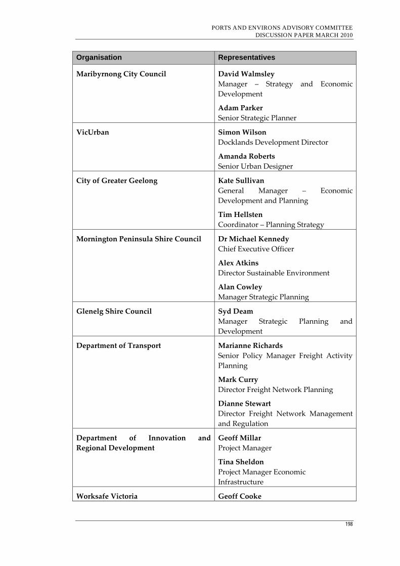
PORTS AND ENVIRONS ADVISORY COMMITTEE DISCUSSION PAPER MARCH 2010
198
Organisation Representatives
Maribyrnong City Council David Walmsley
Manager – Strategy and Economic
Development
Adam Parker
Senior Strategic Planner
VicUrban Simon Wilson
Docklands Development Director
Amanda Roberts
Senior Urban Designer
City of Greater Geelong Kate Sullivan
General Manager – Economic
Development and Planning
Tim Hellsten
Coordinator – Planning Strategy
Mornington Peninsula Shire Council Dr Michael Kennedy
Chief Executive Officer
Alex Atkins
Director Sustainable Environment
Alan Cowley
Manager Strategic Planning
Glenelg Shire Council Syd Deam
Manager Strategic Planning and
Development
Department of Transport Marianne Richards
Senior Policy Manager Freight Activity
Planning
Mark Curry
Director Freight Network Planning
Dianne Stewart
Director Freight Network Management
and Regulation
Department of Innovation and
Regional Development
Geoff Millar
Project Manager
Tina Sheldon
Project Manager Economic
Infrastructure
Worksafe Victoria Geoff Cooke
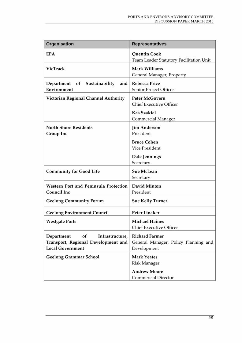
PORTS AND ENVIRONS ADVISORY COMMITTEE DISCUSSION PAPER MARCH 2010
199
Organisation Representatives
EPA Quentin Cook
Team Leader Statutory Facilitation Unit
VicTrack Mark Williams
General Manager, Property
Department of Sustainability and
Environment
Rebecca Price
Senior Project Officer
Victorian Regional Channel Authority Peter McGovern
Chief Executive Officer
Kas Szakiel
Commercial Manager
North Shore Residents
Group Inc
Jim Anderson
President
Bruce Cohen
Vice President
Dale Jennings
Secretary
Community for Good Life Sue McLean
Secretary
Western Port and Peninsula Protection
Council Inc
David Minton
President
Geelong Community Forum Sue Kelly Turner
Geelong Environment Council Peter Linaker
Westgate Ports Michael Haines
Chief Executive Officer
Department of Infrastructure,
Transport, Regional Development and
Local Government
Richard Farmer
General Manager, Policy Planning and
Development
Geelong Grammar School Mark Yeates
Risk Manager
Andrew Moore
Commercial Director
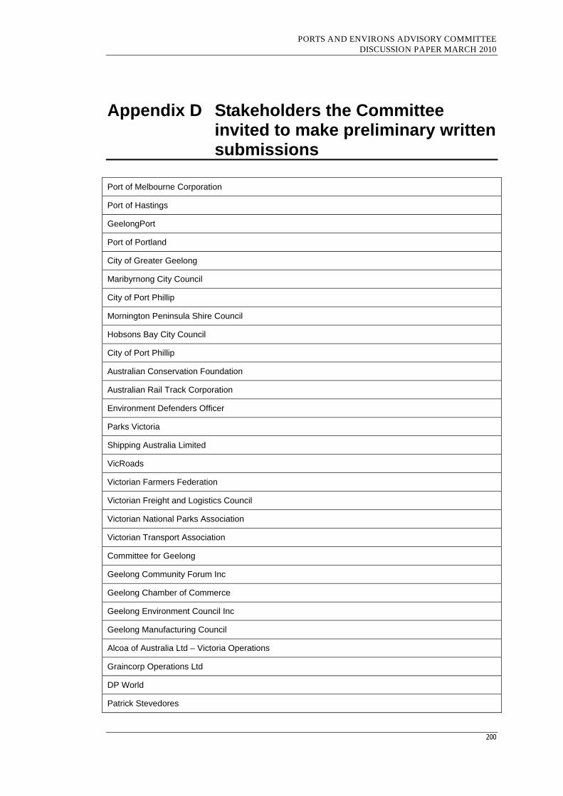
PORTS AND ENVIRONS ADVISORY COMMITTEE DISCUSSION PAPER MARCH 2010
200
Appendix D Stakeholders the Committee invited to make preliminary written submissions
Port of Melbourne Corporation
Port of Hastings
GeelongPort
Port of Portland
City of Greater Geelong
Maribyrnong City Council
City of Port Phillip
Mornington Peninsula Shire Council
Hobsons Bay City Council
City of Port Phillip
Australian Conservation Foundation
Australian Rail Track Corporation
Environment Defenders Officer
Parks Victoria
Shipping Australia Limited
VicRoads
Victorian Farmers Federation
Victorian Freight and Logistics Council
Victorian National Parks Association
Victorian Transport Association
Committee for Geelong
Geelong Community Forum Inc
Geelong Chamber of Commerce
Geelong Environment Council Inc
Geelong Manufacturing Council
Alcoa of Australia Ltd – Victoria Operations
Graincorp Operations Ltd
DP World
Patrick Stevedores

PORTS AND ENVIRONS ADVISORY COMMITTEE DISCUSSION PAPER MARCH 2010
201
Terminals Pty Ltd
BlueScope Steel Limited
Tyabb Ratepayers, Business and Environment Inc
Western Port Chamber of Commerce and Industry
Port Phillip and Western Port CMA

PORTS AND ENVIRONS ADVISORY COMMITTEE DISCUSSION PAPER MARCH 2010
202
Appendix E Stakeholders who provided a preliminary written submission
Port of Melbourne Corporation
Port of Hastings
GeelongPort
Port of Portland
City of Greater Geelong
Maribyrnong City Council
City of Port Phillip
Mornington Peninsula Shire Council
Hobsons Bay City Council
City of Port Phillip
VicRoads
Geelong Chamber of Commerce
Department of Transport
Tyabb & District Ratepayers
Shipping Australia Limited
BlueScope Steel
Parks Victoria
Victorian Farmers Federation
Victorian Freight and Logistics Council
Department of Infrastructure, Transport, Regional Development and Local Government
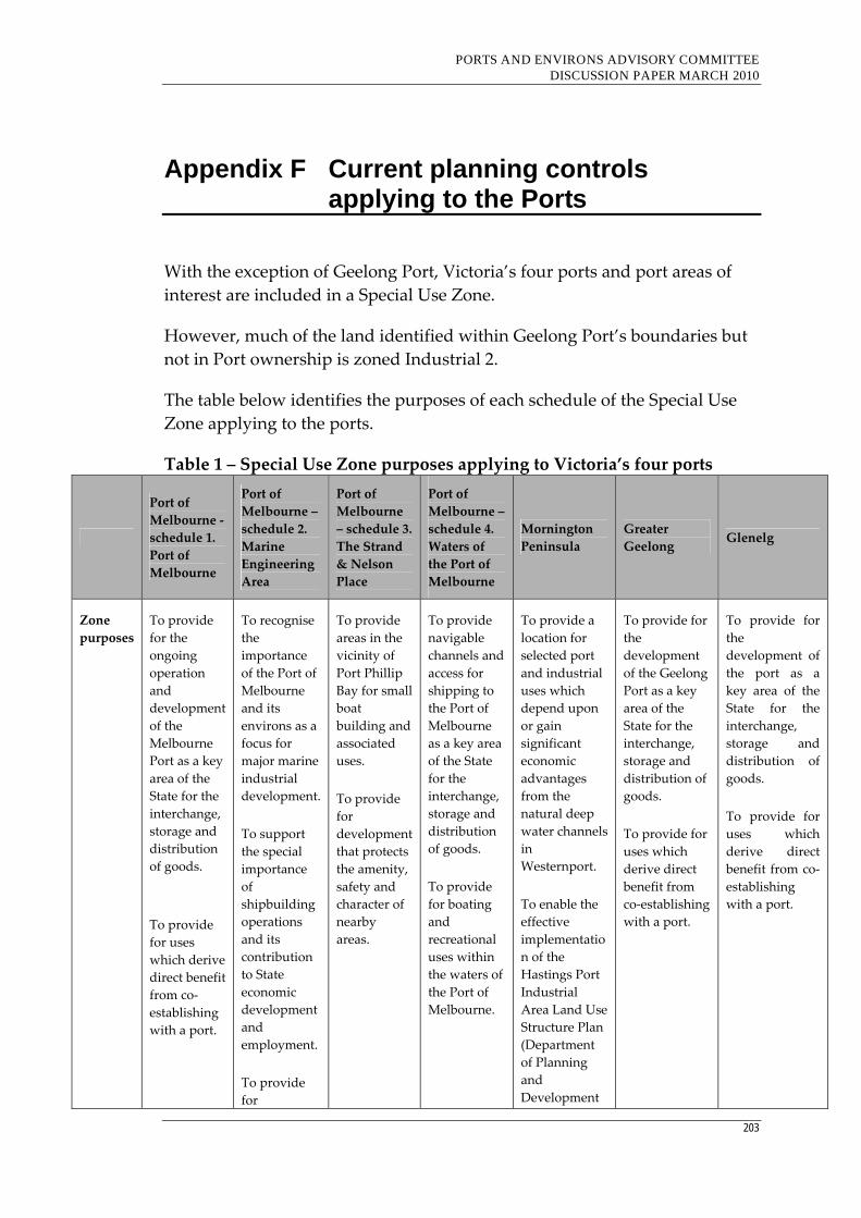
PORTS AND ENVIRONS ADVISORY COMMITTEE DISCUSSION PAPER MARCH 2010
203
Appendix F Current planning controls applying to the Ports
With the exception of Geelong Port, Victoria’s four ports and port areas of
interest are included in a Special Use Zone.
However, much of the land identified within Geelong Port’s boundaries but
not in Port ownership is zoned Industrial 2.
The table below identifies the purposes of each schedule of the Special Use
Zone applying to the ports.
Table 1 – Special Use Zone purposes applying to Victoria’s four ports
Port of
Melbourne ‐
schedule 1.
Port of
Melbourne
Port of
Melbourne –
schedule 2.
Marine
Engineering
Area
Port of
Melbourne
– schedule 3.
The Strand
& Nelson
Place
Port of
Melbourne –
schedule 4.
Waters of
the Port of
Melbourne
Mornington
Peninsula
Greater
Geelong Glenelg
Zone
purposes
To provide
for the
ongoing
operation
and
development
of the
Melbourne
Port as a key
area of the
State for the
interchange,
storage and
distribution
of goods.
To provide
for uses
which derive
direct benefit
from co‐
establishing
with a port.
To recognise
the
importance
of the Port of
Melbourne
and its
environs as a
focus for
major marine
industrial
development.
To support
the special
importance
of
shipbuilding
operations
and its
contribution
to State
economic
development
and
employment.
To provide
for
To provide
areas in the
vicinity of
Port Phillip
Bay for small
boat
building and
associated
uses.
To provide
for
development
that protects
the amenity,
safety and
character of
nearby
areas.
To provide
navigable
channels and
access for
shipping to
the Port of
Melbourne
as a key area
of the State
for the
interchange,
storage and
distribution
of goods.
To provide
for boating
and
recreational
uses within
the waters of
the Port of
Melbourne.
To provide a
location for
selected port
and industrial
uses which
depend upon
or gain
significant
economic
advantages
from the
natural deep
water channels
in
Westernport.
To enable the
effective
implementatio
n of the
Hastings Port
Industrial
Area Land Use
Structure Plan
(Department
of Planning
and
Development
To provide for
the
development
of the Geelong
Port as a key
area of the
State for the
interchange,
storage and
distribution of
goods.
To provide for
uses which
derive direct
benefit from
co‐establishing
with a port.
To provide for
the
development of
the port as a
key area of the
State for the
interchange,
storage and
distribution of
goods.
To provide for
uses which
derive direct
benefit from co‐
establishing
with a port.

PORTS AND ENVIRONS ADVISORY COMMITTEE DISCUSSION PAPER MARCH 2010
204
Port of
Melbourne ‐
schedule 1.
Port of
Melbourne
Port of
Melbourne –
schedule 2.
Marine
Engineering
Area
Port of
Melbourne
– schedule 3.
The Strand
& Nelson
Place
Port of
Melbourne –
schedule 4.
Waters of
the Port of
Melbourne
Mornington
Peninsula
Greater
Geelong Glenelg
development
which
protects the
amenity,
safety and
character of
nearby areas.
1996).
To protect the
environmental
values of the
waters,
coastline and
intertidal areas
of
Westernport
and adjoining
land.
To provide for
the interim
rural use of
land to the
extent
consistent
with
maintaining
land resources
for future port
and port‐
related
development.
To protect the
towns of
Tyabb,
Hastings, Crib
Point and
Bittern by
ensuring that
no port
industrial
development
which may
have an
adverse affect
on the amenity
or safety of
residents
occurs in
proximity to
residential
areas.

PORTS AND ENVIRONS ADVISORY COMMITTEE DISCUSSION PAPER MARCH 2010
205
Other zones that apply in port and port area of interest land include:
Table 2: Other zones that apply in port and port area of interest land
Port Zones
Melbourne Public Park & Recreation Zone
Road Zone 1
Hastings Public Use Zone
Public Use Zone 7 (Other public use)
Public Use Zone 4 (Transport)
Public Use Zone 1 (Service & Utility)
Geelong Industrial 1 Zone
Industrial 2 Zone
Public Park & Recreation Zone
Public Use Zone 4 (Transport)
Public Conservation & Resource Zone
Portland Public Park & Recreation Zone
Overlay controls that apply in port and port area of interest include:
Table 3: Overlay controls that apply in port and port area of interest land
Port Overlay
Melbourne City Ling project Overlay 2
Design & Development Overlay 2
Design & Development Overlay 4
Design & Development Overlay 5
Design & Development Overlay 7
Heritage Overlay 7
Heritage Overlay 8
Heritage Overlay 9
Special Building Overlay 3
Hastings Design & Development Overlay 1
Design & Development Overlay 7
Land Subject to Inundation Overlay
Public Acquisition Overlay 2
Public Acquisition Overlay 4
Vegetation protection Overlay 1
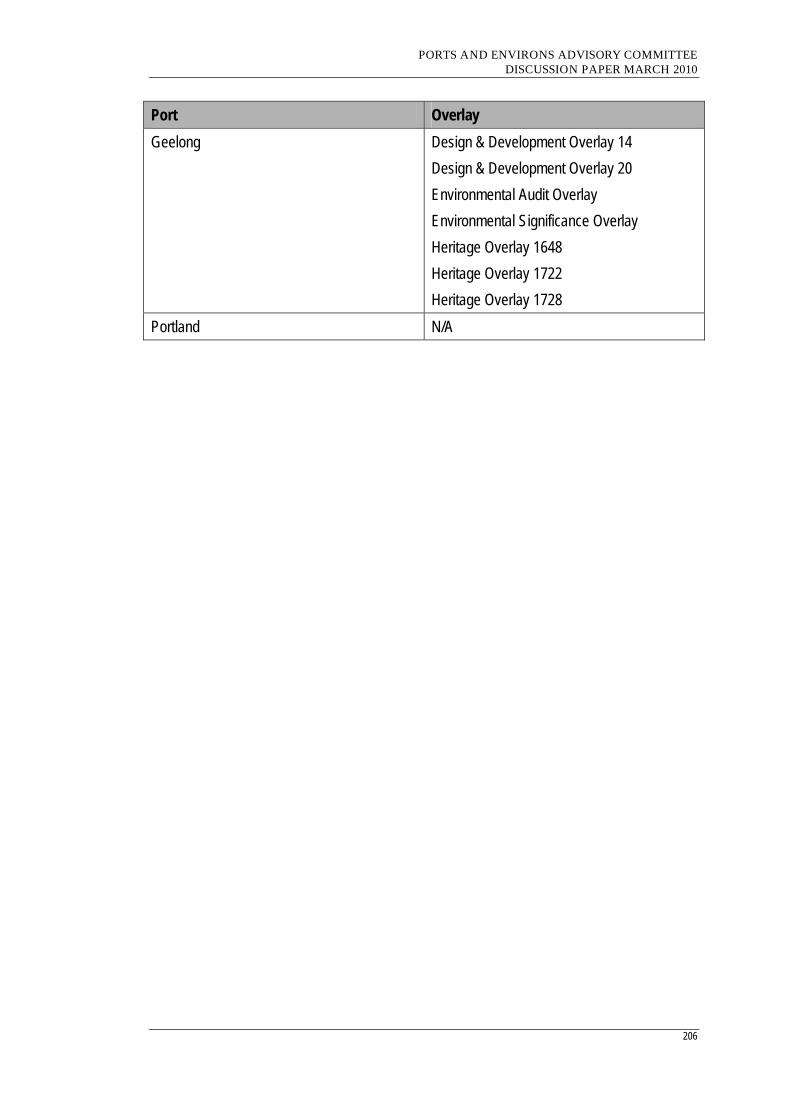
PORTS AND ENVIRONS ADVISORY COMMITTEE DISCUSSION PAPER MARCH 2010
206
Port Overlay
Geelong Design & Development Overlay 14
Design & Development Overlay 20
Environmental Audit Overlay
Environmental Significance Overlay
Heritage Overlay 1648
Heritage Overlay 1722
Heritage Overlay 1728
Portland N/A
PORTS AND ENVIRONS ADVISORY COMMITTEE DISCUSSION PAPER MARCH 2010
207
Appendix G Draft Port Environs Overlay
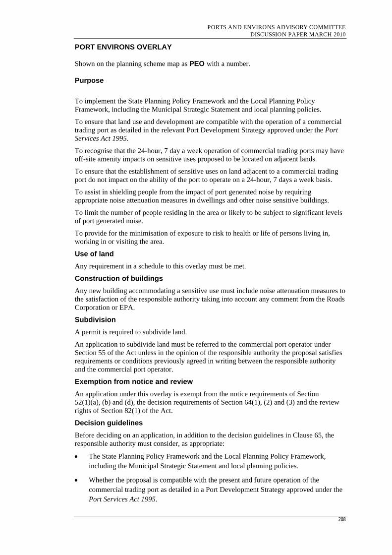
PORTS AND ENVIRONS ADVISORY COMMITTEE DISCUSSION PAPER MARCH 2010
208
PORT ENVIRONS OVERLAY Shown on the planning scheme map as PEO with a number. Purpose
To implement the State Planning Policy Framework and the Local Planning Policy Framework, including the Municipal Strategic Statement and local planning policies.
To ensure that land use and development are compatible with the operation of a commercial trading port as detailed in the relevant Port Development Strategy approved under the Port Services Act 1995.
To recognise that the 24-hour, 7 day a week operation of commercial trading ports may have off-site amenity impacts on sensitive uses proposed to be located on adjacent lands.
To ensure that the establishment of sensitive uses on land adjacent to a commercial trading port do not impact on the ability of the port to operate on a 24-hour, 7 days a week basis.
To assist in shielding people from the impact of port generated noise by requiring appropriate noise attenuation measures in dwellings and other noise sensitive buildings.
To limit the number of people residing in the area or likely to be subject to significant levels of port generated noise.
To provide for the minimisation of exposure to risk to health or life of persons living in, working in or visiting the area.
Use of land
Any requirement in a schedule to this overlay must be met.
Construction of buildings
Any new building accommodating a sensitive use must include noise attenuation measures to the satisfaction of the responsible authority taking into account any comment from the Roads Corporation or EPA.
Subdivision
A permit is required to subdivide land.
An application to subdivide land must be referred to the commercial port operator under Section 55 of the Act unless in the opinion of the responsible authority the proposal satisfies requirements or conditions previously agreed in writing between the responsible authority and the commercial port operator.
Exemption from notice and review
An application under this overlay is exempt from the notice requirements of Section 52(1)(a), (b) and (d), the decision requirements of Section 64(1), (2) and (3) and the review rights of Section 82(1) of the Act.
Decision guidelines
Before deciding on an application, in addition to the decision guidelines in Clause 65, the responsible authority must consider, as appropriate:
The State Planning Policy Framework and the Local Planning Policy Framework, including the Municipal Strategic Statement and local planning policies.
Whether the proposal is compatible with the present and future operation of the commercial trading port as detailed in a Port Development Strategy approved under the Port Services Act 1995.

PORTS AND ENVIRONS ADVISORY COMMITTEE DISCUSSION PAPER MARCH 2010
209
Whether the proposal will result in an increase in the number of dwellings and people affected by noise from port operations or road or rail traffic.
Whether the proposal will result in an increase in the number of dwellings and people affected by exposure to risk to health or life.
Whether the design of the building incorporates appropriate noise attenuation measures.
The views of the port operator.
Notes: Refer to the State Planning Policy Framework and the Local Planning Policy Framework, including the Municipal Strategic Statement, for strategies and policies which may affect the use and development of land.
Check the requirements of the zone which applies to the land.
Other requirements may also apply. These can be found at Particular Provisions.

PORTS AND ENVIRONS ADVISORY COMMITTEE DISCUSSION PAPER MARCH 2010
210
Appendix H Draft Design and Development Overlay
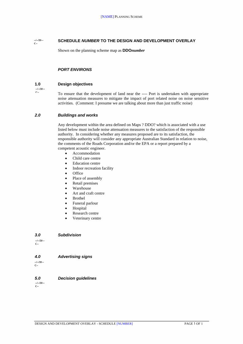
[NAME] PLANNING SCHEME
DESIGN AND DEVELOPMENT OVERLAY - SCHEDULE [NUMBER] PAGE 1 OF 1
SCHEDULE NUMBER TO THE DESIGN AND DEVELOPMENT OVERLAY
Shown on the planning scheme map as DDOnumber
PORT ENVIRONS
1.0 Design objectives
To ensure that the development of land near the ---- Port is undertaken with appropriate noise attenuation measures to mitigate the impact of port related noise on noise sensitive activities. (Comment: I presume we are talking about more than just traffic noise)
2.0 Buildings and works
Any development within the area defined on Maps ? DDO? which is associated with a use listed below must include noise attenuation measures to the satisfaction of the responsible authority. In considering whether any measures proposed are to its satisfaction, the responsible authority will consider any appropriate Australian Standard in relation to noise, the comments of the Roads Corporation and/or the EPA or a report prepared by a competent acoustic engineer.
Accommodation Child care centre Education centre Indoor recreation facility Office Place of assembly Retail premises Warehouse Art and craft centre Brothel Funeral parlour Hospital Research centre Veterinary centre
3.0 Subdivision
4.0 Advertising signs
5.0 Decision guidelines
‐‐/‐‐/20—
C‐‐
‐‐/‐‐/20—
C‐‐
‐‐/‐‐/20—
C‐‐
‐‐/‐‐/20—
C‐‐
‐‐/‐‐/20—
C‐‐

PORTS AND ENVIRONS ADVISORY COMMITTEE DISCUSSION PAPER MARCH 2010
212
Appendix I Draft Development Plan Schedule

PORTS AND ENVIRONS ADVISORY COMMITTEE DISCUSSION PAPER MARCH 2010
213
SCHEDULE xx TO THE DEVELOPMENT PLAN OVERLAY Shown on the planning scheme map as DPO ?? PORT OF xxxxx DEVELOPMENT PLAN The development plan provides criteria for any future use and development of land within the Port of ?.
1.0 Requirement before a permit is granted No specific requirements
2.0 Conditions and requirements for permits No specific requirements
3.0 Requirements for development plan The development plan must include:
Site Analysis Plan
Surrounding land uses and development
Vehicle and pedestrian links
Public transport
Topography and relationship to high water mark
Landscape features
Development concept plan
the proposed layout and use of each site,
any buildings and works to be demolished;
the location, appearance, height dimensions and floor area of all new buildings and works;
a schedule showing the materials, finishes and colours of all external buildings and structures;
the number, location, dimensions, and layout of all car parks and access ways to and from them;
a management plan for the operation and maintenance of the car and heavy vehicle parking areas;
the location and dimensions of all bicycle, vehicle and pedestrian ways;
a traffic management plan which must show any traffic management and traffic control works considered necessary in adjoining and nearby roads when the development is completed;
the means of vehicular and pedestrian ingress to and egress from the land;

PORTS AND ENVIRONS ADVISORY COMMITTEE DISCUSSION PAPER MARCH 2010
214
the impact on any areas of environmental significance, particularly sensitive coastal environments.
a landscape plan which includes details on furniture, lighting and the location, quantity and size at maturity of all proposed plants, and the botanical names of the plants, the location of all areas to be covered by lawn or other surface materials and provides a specification of works to be undertaken prior to planting; and a management plan for controlling and maintaining the open space and landscaped areas.
4.0 Display of Development Plan
The development plan shall be made available for public inspection at ?????? for 14 days prior to its consideration by the responsible authority.
5.0 Decision guidelines Before deciding on application, the responsible authority must consider in addition to the matters set down in Clause 65 and the zone:
any written comments received in response to the display of the development plan;
the impact of the proposed development and use on adjacent and nearby properties, roads and
other physical infrastructure;
the impact of traffic generated by the proposal and whether it is likely to require special traffic management or control works in the neighbourhood;
points of access to and from the land and whether they are suitably located;
the layout and management of car and heavy vehicle parking areas and accessways to and from them;
any relevant Council policy;
whether the location, bulk, height and appearance of any proposed buildings or works will be in keeping with the character and amenity of the area.

PORTS AND ENVIRONS ADVISORY COMMITTEE DISCUSSION PAPER MARCH 2010
215
Appendix J Draft Particular Provision – Port Environs Protection

PORTS AND ENVIRONS ADVISORY COMMITTEE DISCUSSION PAPER MARCH 2010
216
NEW PARTICULAR PROVISIONS CLAUSE:
‘PORT ENVIRONS PROTECTION’
Rationale for a new clause.
A new Particular Provisions Clause is a technique to ensure applications for
use or development in the environs of ports are required to take into account
the activities of the port for the protection of the amenity of occupants of the
intended use or development as well as for the protection of the port.
The Particular Provisions of the planning scheme provide for a range of
matters such as ‘uses with adverse amenity potential’, ‘advertising signs’,
‘service stations’, ‘wind energy facilities’, ‘shipping container storage’ and the
like. These provisions have the advantage of ensuring that the impacts of a
particular land use or issue can be adequately managed.
The clause simply requires that in addition to the provisions of the prevailing
zones that surround ports, the activities of the port must be taken into account
before any use or development application is determined.
The clause is an alternative to a Port Environs Overlay. While not as
transparent as zone provisions or the use of an overlay it can provide for the
general area around a port without having to specifically or scientifically
identify that area.
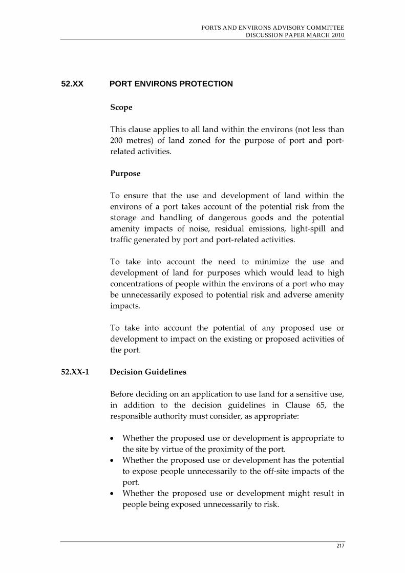
PORTS AND ENVIRONS ADVISORY COMMITTEE DISCUSSION PAPER MARCH 2010
217
52.XX PORT ENVIRONS PROTECTION
Scope
This clause applies to all land within the environs (not less than
200 metres) of land zoned for the purpose of port and port‐
related activities.
Purpose
To ensure that the use and development of land within the
environs of a port takes account of the potential risk from the
storage and handling of dangerous goods and the potential
amenity impacts of noise, residual emissions, light‐spill and
traffic generated by port and port‐related activities.
To take into account the need to minimize the use and
development of land for purposes which would lead to high
concentrations of people within the environs of a port who may
be unnecessarily exposed to potential risk and adverse amenity
impacts.
To take into account the potential of any proposed use or
development to impact on the existing or proposed activities of
the port.
52.XX‐1 Decision Guidelines
Before deciding on an application to use land for a sensitive use,
in addition to the decision guidelines in Clause 65, the
responsible authority must consider, as appropriate:
Whether the proposed use or development is appropriate to
the site by virtue of the proximity of the port.
Whether the proposed use or development has the potential
to expose people unnecessarily to the off‐site impacts of the
port.
Whether the proposed use or development might result in
people being exposed unnecessarily to risk.
PORTS AND ENVIRONS ADVISORY COMMITTEE DISCUSSION PAPER MARCH 2010
218
Whether the proposed use or development might lead to
pressure to impede the long term development of the port.
In deciding any application the responsible authority may, as
appropriate, take into account the views of the Environment
Protection Authority, WorkSafe, the relevant port manager and
the relevant Port Development Strategy prepared pursuant to
the Port Services Act 1995.
For the purposes of this clause, sensitive uses include Accommodation, Arts and craft centre, Child care centre, Education centre, Food and drink premises, Hospital, Office, Place of assembly, Restricted recreation facility and Retail premises.