posted by: dr. munir el-mahdy organized and translated by
TRANSCRIPT

Posted By: Dr. Munir EL-Mahdy
Organized and translated by: Nehal Zakareya
2020

By the grace of God, I finished the posts series (Al-Baharyia Oasis) where the last post was (Al-Baharyia
Oasis (17)). All posts were compiled into a PDF file in both Arabic and English in order to make it available to
the largest possible group of students.
My idea was to post and illustrate the most important geological features in the Baharyia Oasis region and
as I mentioned the most important places that must be visited when you go to Baharyia Oasis, all of this was an
initiative of me to compensate students who were unable to go on a trip to Baharyia Oasis because of the
Corona pandemic, so I hope that they have they benefited and had information about the place, which would
enable them to develop a correct and rich plan if they even went to Baharyia Oasis on their own.
I want to express my thanks and appreciation to all the people who liked and comment on the posts series,
as it was all a great encouragement to complete posting the rest of the series.
I want to thank Geologist/ Nehal Zakareya for her efforts in translating the posts and compiling them all in
one file. Special thanks go to the supervisors, Prof. Dr. Adel Ramadan Mustafa, Professor of Structural Geology
at the Faculty of Science, Ain Shams University, and Professor Ahmed Neazy Elbarqooqy, Professor of
Sedimentary Geology, Faculty of Science, Cairo University, for their great effort in this field trip. See you in
another posts of another field trip.
Munir El-Mahdy

Baharyia Oasis (1)
Baharyia oasis is considered to be one of the most famous oases in the Western Desert in Egypt. It is located
on an area of more than 2000 square kilometers. It has about 400 eyes of mineral and sulfur water warm and cold.
In 1911 a German scientist called Ernst Stromer found the skeleton of four species of dinosaurs known as
Spinosaurus belonging to the Cretaceous Baharyia Formation at Baharyia oases and preserved in the Berline
Museum in Germany, but the museum was destroyed during World War II and most parts of the dinosaur were
lost, and some parts remain of photographs and drawings made by German geologist.
Later on, several fossils for this dinosaur had been found in Marrakesh, Algeria and Niger.
2014#رحلة_الواحات_
#Geology
#Baharya_Oasis
Map view of the Baharyia Oasis and a photo for Ernst Stromer with a bone of the Egyptian Dinasour

Baharyia Oasis (2)
The Baharyia Oasis is one of the most beautiful geological fieldtrips that I traveled in Egypt. I visited the
Baharyia Oasis twice, the first time when I was a student at the third level in the faculty of Science in (2006), and
the second time I was in Khalda company in 2014 and almost twice, we went down the same path on the same
rest.
On the university trip, the professor noticed that one of the rest walls is painted with rocks on the mushroom
shape in the white desert in the marine oases. He was really impressed with the drawing and its accuracy, and
explained its idea to us in detail.
The white desert is composed mainly of snowy white chalk, which is the main reason for calling this area
“white desert”. The chalk is related to the Cretaceous Khoman Formation, which deposited in the deep marine of
the Tethys Sea approximately 14.5 million years ago.
The White Desert is considered one of the most important areas that distinguish Baharyia oases from other
oases. Its area is approximately three thousand square kilometers and it is a destination for tourists interested in
safari and desert. In 2002, Egypt considered Baharyia oases as a nature reserve area. Most visitors of the white
desert prefer camping, where it attracts stars and planets' lovers, because of the wide view of the sky and the
beauty of the natural terrain in the area, something that is not available anywhere else easily.
2014#رحلة_الواحات_
#Geology
#Baharya_Oasis
White desert of the Cretaceous Chalk, Khoman Formation, Baharyia Oasis, Western Desert of Egypt.
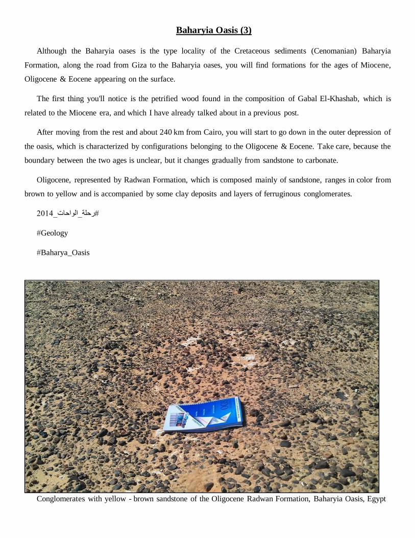
Baharyia Oasis (3)
Although the Baharyia oases is the type locality of the Cretaceous sediments (Cenomanian) Baharyia
Formation, along the road from Giza to the Baharyia oases, you will find formations for the ages of Miocene,
Oligocene & Eocene appearing on the surface.
The first thing you'll notice is the petrified wood found in the composition of Gabal El-Khashab, which is
related to the Miocene era, and which I have already talked about in a previous post.
After moving from the rest and about 240 km from Cairo, you will start to go down in the outer depression of
the oasis, which is characterized by configurations belonging to the Oligocene & Eocene. Take care, because the
boundary between the two ages is unclear, but it changes gradually from sandstone to carbonate.
Oligocene, represented by Radwan Formation, which is composed mainly of sandstone, ranges in color from
brown to yellow and is accompanied by some clay deposits and layers of ferruginous conglomerates.
2014#رحلة_الواحات_
#Geology
#Baharya_Oasis
Conglomerates with yellow - brown sandstone of the Oligocene Radwan Formation, Baharyia Oasis, Egypt

Baharyia Oasis (4)
After completing the follow-up of Oligocene's Radwan Formation, you will find El Hamra Formation layers.
As we mentioned, the boundary between Radwan Formaiton and Hamra Formation is almost unclear, but is
represented in a gradual change from pure sandstone to carbonate sediments.
There are not many details in El Hamra Formation, they are mainly made of limestone yellow in color that
tends to brown and the most important thing that distinguishes them is the presence of fossils Oyster, Nummulites
& burrows, which represent the Maximum flooding surface.
For more order and sequencing of ideas, on your way from Giza to the Baharyia oasis, along the way you will
find sediments of three different configurations for three different eras (Gabal El-Khashab Formation - Miocene
/ Radwan Formation - Oligocene / El Hamra Formation - Eocene)
It means that you are moving from newest to oldest when you go to Baharyia oases.
#Geology
#Baharya_Oasis
Prof. Dr. Ahmed Neazy while discussing the composition of El Hamra Formation along the Baharyia - Giza
desert road.

Baharyia Oasis (5)
When you see the sequence of layers from the newest to the oldest (Miocene, Oligocene & Eocene), be careful
to take pictures of each geological layer in front of you, and don't forget to put scale (let it be a pen or anything
known to be its size), because without scale we cannot take the image into consideration and try to write a small
word describing each image so that you do not forget what you noticed in that region, and do not forget to record
the location geographic coordinates of the point where you stand, whether by mobile or GPS.
The trouble on the first day will make you very eager to come back to the hotel for a break.
I remember very well that when we were students in 2006 the bus stopped in a company rest house, and I also
remember that a number of high-level apartments were allocated for girls and teachers, but we, the boys and the
assistant teacher, went down in a place divided into the rooms of each room in it Four of the iron beds and one
bathroom in general. I was a making jocks on these rooms and calling them Villa, and friends laughed a lot
because of that.
Despite that, we quickly adapted to the place, laughed, and played many puzzle and dice games, known as the
Bank of Fortune.
This is the pleasant part of the trips, and it is that we graduated from the university routine represented in the
pressure of studying and exams, as it strengthens the relationship between colleagues and friends.
Especially if its duration is short, we do not have opportunities to quarrel, especially when the environment
around us is not arranged, as I explained earlier, so we tolerated everything in order to enjoy and benefit as much
as possible.
I advise you to invest in university trips because it is the only beautiful thing in it. When you graduate from
the university, you will only remember the trips that you went with with friends because it is the only thing that
brings you out of the framework of routine and boredom as you will bridge the gap between you and your teachers
because you will see the human side of them, other than the lectures and Absenteeism, attendance and grades for
the year. Real friendships are made on trips, not at work.
Take a lot of pictures of everything that surrounds you and take pictures of yourself and your friends because
you will someday miss these exceptional days.
In 2014 the company made a reservation in a wonderful hotel, as a kind of rest after the long tired day, my
problem with the hotel was due to the lack of numbering the rooms but rather they were called by specific names.
And the name of the room that I stayed in was "good sleep" ............ Actually as I mentioned, of course you
can imagine the procession in which they and my friends were giving us because of the misfortune that he called
"good sleep".

Baharyia oasis (6)
In this post I will not be showing pictures with friends but rather I will explain to you what is shown on this
attached map.
Initially, when I saw such maps, I was horrified by the amount of complexity that I see and I was afraid that
I would not understand them, but gradually I divided them into parts and tried to understand each part separately
until I was able to determine the content that I need and the content that I will not need.
First / You have four different colors. Light blue symbolizes Eocene Farafra Formation, then dark blue
Maastrichtian Khoman Formation symbolizes the beginning of Cretaceous, then green, and this is El-Hefhuf
Formation. It is considered Campanian (Cretaceous also but slightly older than Maastrichtian) and finally yellow
symbolizes Baharyia Formation from the Cenomanian who is considered the oldest Cretaceous in the region.
Focus on the map in order to know the distribution of the formations in the area and and concentrate on some
locations that we are going to discuss in details like Gebel Ghorabi, Gebel Radwan, Jabal Al Hafouf, Gebel El
Hefhuf and El Harra.
Simplified geological map and cross sections of the Bahariya Depression and the area north of the Farafra
Depression. (Moustafa et al., 2003).
Moustafa, A.R., Saoudi, A., Moubasher, A., Ibrahim, I.M., Molokhia, H., Schwartz, B. (2003): Structural
setting and tectonic evolution of the Bahariya Depression, Western Desert, Egypt. GeoArabia, V.8, no.1.pp.91 -
124.

Baharyia oasis (7)
As you start entering the oasis, the first thing you'll find is Gebel Ghorabi (marked with a red rectangle in the
previous post and written under figure 8)
The mountain extends over a distance of 36 kilometers soon, and is made up of the Baharyia formation and
that is attached to the Cenomanian as we mentioned before and the Naqb Formation layers above it. This follows
the Eocene era and is composed of Limestone and layers of Iron ore deposits and is considered one of the
important sources of iron in the oasis region (purple color on the map). Of course, the presence of Eocene directly
above Cretaceous means the presence of the so-called unconformity.
Synthetically, a mountain mount made up of a folded folds array of en echelon folds. In order not to be difficult
for you to understand that word, the topic is very simply that any set of combinations (bundles of crevices or
folds) are parallel to each other in a map view that we call en echelon structures.
Sometimes it is in a common area between two rifts (or two folds) and sometimes we do not find it.
*A quick tip * When you walk along the first structure (suppose it is a crack) all the way to the end, then
after that you move to the other parallel rift and find it to the right of the first rift so know that you are in front of
right-stepped en echelon faults and the same idea if you find the second rift on the left The first rift is in front of
you left-stepped en echelon faults and the same idea is applied to the folds.
When we return to the aerial view we took, we will find that the gebel ghourabi is made up of a set of folds
extending in the direction of E - NE and making a right - stepped en echelon folds. Each fold is represented by a
white line, symbolizing the hinge line. In the event that the arrow is bidirectional, this means that there is a double
plunging anticline, meaning that the hinge line of the fold is oblique in both directions (as shown in the picture
shown) and in the case that the arrow has one head, then this
means plunging anticline.
Also note that in a large strike slip fault, it divides the
fourth fold by approximately half (the fourth from the right
or the second from the left).
By the way in this post
we have based on the
research that I have
attached to the comments
of the previous post.

Baharyia Oasis (8)
Finally arrived!!!!!!!!!
The surprise that I mentioned to you in the previous post, a video of Professor Adel Ramadan and Professor
Ahmed Niazi as they explain the most important geological characteristics of the Baharyia oasis region, during
the oasis field trip in 2014.
At the same time, I have attached to you a research with an explanation of more details for the region for those
who want to enrich their knowledge.
Special thanks go to the supervisors, Prof. Dr. Adel Ramadan Mustafa, Professor of Structural Geology at the
Faculty of Science, Ain Shams University, and Professor Ahmed Neazy Elbarqooqy, Professor of Sedimentary
Geology, Faculty of Science, Cairo University for their agreement to publish this video.
And a very special thanks to my friend Amr Mostafa that he allowed me to publish his video.
https://pubs.geoscienceworld.org/geoarabia/article/8/1/91/566877/structural-setting-and-tectonic-evolution-
of-the
#Geology
#Baharya_Oasis
2014#رحلة_الواحات_

Baharyia Oasis (9)
After the hearty meal in the video of Professor Adel Ramadan and Professor Ahmed Niazi, we return to you
in new photos and a new explanation.
-Where do we stand now?!
* We are at the entrance to the Baharyia oases, at an area called Naqab El-Raha, and this is the beginning of
the oasis depression (red arrow on the map), and then the rocks begin to change from Eocene Naqab Formation
to Cretaceous (Cenomanian) Baharyia Formation, we will find it taking the form of an anticline and We will
notice a change in the slope of the layers from the horizontal to the oblique, which is accompanied by the angular
unconformity between the Eocene and Cretaceous layers.
a: panoramic view of the anticline form at the entrance of the Baharyia Depression (Naqab El-Raha area). b.
Shows the change of the layers dip along the anticline form horizontal to the angular unconformity between the
Eocene Naqab Formation to the Cretaceous (Cenomanian) Baharyia Formation.
Baharyia Oasis (10)
We have come here to the great wonderful, the crown jewel as it is spoken in words, Jabal Al-Dest, which is
the type section for the Baharyia formation in Egypt, simply means any person in Egypt who wants to see Baharyia
Formation must go there, and of course I already told you that it is required for an experience geologist go to the
geological field to observe the geology from the surface, so that you can imagine its shape in the subsurface. That
is why the oil companies prepared geological fieldtrips every period, because there are several unimaginable
features that we cannot understand them before seeing them on the surface.
The important thing is that Gabal El-Dest attracted the attention of many scientists a long time ago, and the
first of them was the German scientist Ernst who discovered the Egyptian dinosaur in the year 1911.
In 2000, a dinosaur structure was discovered through a scientific mission to the University of Pennsylvania,
USA, which is considered one of the largest dinosaurs discovered in our planet, which belongs to the Cenomanian
era in Egypt. (Source in the first comment)
Gabal El-Dest is composed of five basic rock units, which we will discuss in detail:
Unit. 1: Rippled sandstone and shale
Unit. 2 Shale with thin rippled sandstone layers
Unit. 3 Cross bedded sandstone with erosional base
Unit 4. Shale with basal sandstone beds
Unit 5. Shale, siltstone and sandstone with basal lag
When you ascend to the top of the hill, you will find above the Baharyia formation, the Eocene Limestone
layers that follow the Naqab Formation
By the way, I advise you to climb to the top of the mountain because you will see a wonderful landscape
Unfortunately I could not take a picture and therefore I did not attach an illustrative photo here.

Panoramic view of Dist and Maghrafa hills,
the type locality sections of the Cretaceous,
Upper Baharyia Formation, Baharyia Oasis,
Egypt, with a photo for Ernst Stromer
during his discovery for the Egyptian
dinosaur 1911 .

Baharyia Oasis (11)
The first thing we'll notice on the bottom is Unit. 1: Rippled sandstone and shale, these are layers of sandstone
with layers of shale.
Sandstone is distinguished as fine grained, brownish to greenish gray and bioturbated (rich in fossil remains
of living things), the most famous of which is the oyster shells. It is also distinguished in the form of ripple marks
and Flasser structure.
The sandstone layers are grey, fissile (chip or chip) and non-calcareous (there is no limestone residue).
Be careful that you must describe everything that is found in rocks (its color, shape, size and shape of the
grains, accompanying minerals, accompanying fossils, do fossils affect the layers) in order to determine the
sedimentary environment, and conclude whether it is possible to benefit from it economically or not. A
sedimentary structure gives a very strong indication that the environment in which the layers were deposited is a
small or secondary marine environment, which is often a small bay branched from an ocean.
#Geology
#Baharya_Oasis
2014#رحلة_الواحات_
Cross bedding and flasser structure (Low energy deposition) affecting sandstone of the Cenomanian Upper
Baharyia Formation, Baharyia oasis, Egypt.

Baharyia Oasis (12)
- Well then, what is the content of our topic today?
* Let us refer back to the post in which we mentioned that Gabal El Dist represents the upper Baharyia
formation and that it is divided into five small units.
And we were talking about the first unit, which is mainly composed of Sandstone and shale
So the second unit of what is made up?
Unit. 2 / Shale with thin rippled sandstone layers
It is mainly made of shale, graded from dark gray to reddish brown and rich in coal sediments with some
sandstone sediments.
The layers of shale are rich in some iron deposits, plant fossils, and oyster shells, in addition to the Egyptian
dinosaur fossils discovered by the scientist Stromer in 1911 (link to the research in the last post).
Often this rock formation is characteristic of a calm or less moving sedimentary environment such as swamps,
for example.
Stromer, E., 1914. Die topographie und geologie der strecks Gharag Baharije nebst Ausfuhrungen, uber die
geologische Geschichte Agyptens. Abhandl. Konig. Bayerische Akademie der Wissenschafte Math.-Phys. Klasse
24, München, 1-78.
Shale beds with thin rippled sandstone layers representing the 2nd lithological unit of the Cenomanian
(Cretaceous) upper Baharyia Formation, Baharyia oasis, Egypt with Prof. Dr. Ahmed Neazy El-Barkooky (Prof.
of sedimentology, Cairo University, Egypt) during his discussion in the field trip.

Baharyia Oasis (13)
The third Rock unit we'll talk about is:
Unit. 3 Cross bedded sandstone with erosional base
They are layers of sandstone that are distinctly crossbedding as shown in the image, representing a
sedimentary environment called (fluvial channel).
Well, what is the word cross bedding?
* They are horizontal layers of sandstone, on which layers of sandstone are deposited at an angle of inclination,
and they appear as a cross.
This indicates that sedimentation was done through a stream (whether water or air stream) and this stream
changes its direction every period and the direction change is the reason for the change of slope of the layers.
The term fluvial channel in the sense that the rocks were deposited as a result of the flow of water in a river
course and is divided into five basic types that differ according to the location of sedimentation in the river,
whether in the beginning, middle, or end. The five types need some detailed explanation, so I will try to explain
it later if there is an opportunity available, but I will just mention their name:
(1) alluvial fans, (2) fan deltas, (3) braided-river deposits, (4) meandering-river deposits, and (5) incised-
valley-fill deposits

Baharyia Oasis (14)
Today we will talk in our last post to close the Upper Baharyia formation chain.
We will talk about:
Unit 4. Shale with basal sandstone beds
It is made up of layers from Shale and its base is made of sandstone.
The shale color is mainly grey and changes to brown whenever we go upward, and this is due to the fact that
it is rich in iron elements that have oxidized and earned it this dark color.
And of course the shale is rich in fossils ostera (a) and (b) Exogyra columba as shown in the attached pictures
(not from my photos, but from Wikipedia).
The sandstone layer at the bottom of the rock unit is fine grained sand in the shape of a flaser bedding, as
mentioned above, and its thickness is very small in what is known as lamina.
From the characteristics of the shale and sandstone they concluded that its sedimentary environment is almost
a limited marine environment or is almost closed to the remainder of the bay.
Unit 5. Shale, siltstone and sandstone with basal lag.
As another rocky unit found in the Upper Baharyia formation, the Eocene limestone layers above it follow
the Naqab formation. It is characterized by the presence of the sedimentary form known as (C) Glossifungites
iohnofacies as shown in the attached picture (not pictorial).
And facies have the form of horizontal or presidential drilling or U-shaped formed in Mud rock when they
are accompanied by residues of carbonate or siliclastics to give them the required hardness and often consist in
the layers that were deposited after regression of the sea, or in other words during the transition from the marine
environment to the continental environment.
We notice in this sequence the presence of what is known as coarsening upward, meaning that the layers
increase in the size of the granules in them as we go up (shale followed by silt stone followed by sandstone) and
with fossils such as fish teeth, Exogyra columba, Gigantichthys spines in addition to previous facies, It gave the
impression that the sedimentary environment of this rocky unit is mostly deltaic or deltaic or estaurine
environment.
I have thus concluded the whole talk about Upper Baharyia formation, I hope the picture is clear to you.
The picture is with my role model, Professor Adel Ramadan, who one day I hope will reach his level in
knowledge, experience and ethics.

Baharyia Oasis (15)
Black Desert: One of the places I love in the Baharyia oasis, I love it even more than the white desert (for no
apparent reason).
The black desert was formed as a result of volcanic eruptions that produced basalt rocks that covered the
whole region and gave it the distinctive black color to it.
If you focus on the top of the mountain, you will notice a basalt that takes the form of five-pointed or six-
shaped pillars, which is called columnar joints.
- Well, then what is the reason for its formation?
* Simply because when lava comes to the surface, it gradually cools down and the cooling process is
accompanied by shrinkage that leads to the formation of quintet or hexagonal cracks in rocks of different shapes
and sizes.
Basalt rocks cover the Cenomanian era rocks represented by the Lower Baharyia Formation which represents
five rock units.
Columnar Joints of
Basalt in the Black
desert, covers the
Cenomanian Lower
Baharyia Formation,
Baharyia Oasis, Western
Desert, Egypt.

Baharyia Oasis (16)
Well, we talked about the Black Desert previously and we mentioned that it is composed of basalt caused by
volcanic eruptions.
- Well then, what is lying under the basalt?
* When the volcano erupted and lava came out of it, it covered the layers of the Lower Baharyia of the
Cretaceous era (Cenomanian).
Lower Baharyia consists of five rock units exactly as in Upper Baharyia.
The two rock units are:
Unit 1. Rippled sandstone and shale (tidal flat / bay deposits)
Unit 2. Shale with thin rippled sandstone layers (Swamp environment)
Unit 3. Cross bedded sandstone with erosional base (fluvial channel)
Unit 4. Shale with basal sandstone beds (tidal flat and transgressive central basin mud)
Unit 5. Shale, siltstone and sandstone with basal lag (brackish to restricted marine)
Almost the same characteristics as Upper Baharyia, so I just wrote that I wrote the title of each rock unit and
its sedimentary environment.
Prof. Dr. Ahmed El Barkooky, prof. of sedimentology, Cairo University, while discussing the cross bedded
sandstone intercalated with shale beds, which characterized the Lower member of Cenomanian Baharyia
Formation, Baharyia Oasis, Egypt 2014

Baharyia Oasis (17)
The last points we'll be talking about are: Crystal Mountain.
And it will be considered one of the most important tourist attractions in Baharyia Oasis (with the white and
black deserts, of course). The mountain is located near the white desert.
The reason for this name is because it is rich in Calcite & Barite crystals.
It is said that the mountain defected during the work of the Baharyia oasis road, parts of it highlighting the
shape of the crystals were broken, which in turn attracted the eyes of tourists.
The mountain is made up of chalk layers that follow Khoman, which are the same layers of the white desert
region that we talked about previously.
It is common for those crystals to form a quartz, but with a study of the crystal shape of the borate, they found
that the crystals take the form of rhombohedral or scalalenohedral shape, whereas in the form of quartz crystals
have 6 sides and are hierarchically shaped.
In addition to the Moho scale of hardness, where in the case of quartz the hardness is 7 and in the case of
calcite the hardness is 3.
The pictures have a general crystal mountain and a small crystal shape in the area.
A panoramic view of the crystal mountain, composed mainly of Cretaceous chalk of Khoman Formation with
a Barite and Calcite Crystals.