precision photogrammetry a tool of geodesy
TRANSCRIPT

Precision Photogrammetry a Tool of Geodesy*
DR. HELLMUT SCHMJD,
Ballistic Research Laboratories, A berdeen, Md.
I F ONE may consider photogrammetry to bea geodetic mensuration technique, as it is
in Europe, then photogrammetry, by definition, is a tool of geodesy and one may wonderabout the logic of the title of this paper. However, generally speaking, the application ofphotogrammetry for geodetic purposes hasbeen limited to such problems as are conventionally associated with the terminology ofsurveying and topographic mapping.
In line with the subject of this session,"New Photogrammetric Systems" I do notintend to talk about the traditional use ofphotogrammetry. I should like to elaboratesomewhat on the potential which photogrammetry, in my opinion, offers in connectionwith methods which are presently almostundisputed in the domain of classic geodetictriangulation.
It is easy to accept the expression:" othing succeeds like success." Now, it is exactlythe lack of success by which photogrammetry is plagued when one hopes to establishprecise geodetic control by the methods ofstrip and block triangulation. That is not saying that such data have not been successfullyobtained for the purpose of the associatedphotogrammetry mapping procedure. Butsuch control data definitely do not have thesame properties as those obtained by conventional geodetic triangulation.
If photogrammetry intends to contributeto the problem of establishing geodetic control, it is necessary to develop an approachto the photogrammetric problem which inall of its individual steps equals in qualitysimilar operations executed painstakinglyduring traditional geodetic triangulationwork. The compatibility has to be assured inregard to the basic principles of an exactmeasuring method as well as to the problemof quality control by rigorous statisticalmeans. To expect that such a method willemerge from the organic development ofpresen today photogrammetric resti tu tiontechniques, at the best, will delay unnecessarily the assistance which photogrammetrycan give to the interest that was lately reo
vived in three-dimensional geodetic triangulation.
The critical evaluation of any exact measuring system demands a rigorous mathematical model which serves as the basis of aleast squares adjustment of the required excess observations. Furthermore, all individualsteps encountered in the phase of the dataacquisition, as well as in the process of thedata evaluation, have to be investigated forthe purpose of determining the metric quality of the individual components enteringinto a specific measuring system. Only by determining the internal accuracy of the individual instrumental components and environmental influences will it be possible toestimate in a significant way the unavoidableindividual random errors.
The rigorous statistical treatment in connection with a clearly defined mathematicalmodel will then enable making the study ofthe propagation of these random errors intothe final result. Finally, the critical evaluation of actual full-scale experiments will provide the information by which the hypothesisof the measuring method can be validated orimproved by the detection and isolation of unexpected bias errors.
An analysis of the method of geodetictriangulation will clearly demonstrate theclose adherence of the geodetic triangulationpractice to the aforementioned principles.
Let us now discuss some of the consequences which one has to accept if one wantsto develop the photogrammetric method as atool of geodetic control triangulation.
Photogrammetry has-with justified pride-always proved to be a method independentof the need of any surface activity withinthe area to be surveyed. The resulting consequences are the problems of pass-point identification and transfer. One may considerstereoscopic viewing as an adequate tool foridentification and furthermore, one can hopefully anticipate the development of imagecorrelation techniques to provide an automatized solution to the problem of pass-pointtransfer. Nevertheless, the fact must be taken
* Paper presented at the Semi-annual Convention of the American Society of Photogrammetry, :\JewYork, October 1961.
779
780 PHOTOGRAMMETRIC ENGINEERING
into account that even the most accuratelyidentified, and accordingly accurately determined, point represents for geodetic control purposes an entirely useless triple of coordinates, as long as it is not possible to correlate these coordinates with a specific permanently existing physical feature in nature.As a matter of fact, this identification mustbe possible and well within the limits of themean errors of the correspondingly computedcoordinates. In short, it will be necessary todevelop an effective and economical methodfor establishing suitable markers, thus reducing, for the sake of precision, the targetidentification problem during the process ofevaluating the photogrammetric record, andat the same time enabling the coordinationof the computed triangulation results with aspecific location in the field.
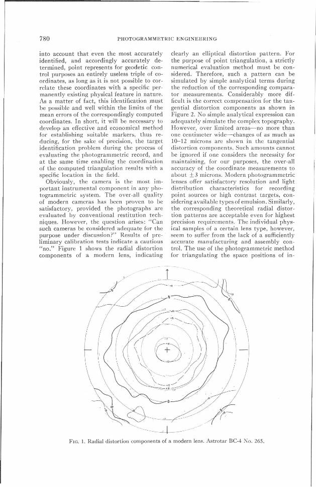
Obviously, the camera is the most important instrumental component in any photogrammetric system. The over-all qualityof modern cameras has been proven to besatisfactory, provided the photographs areevaluated by conventional restitution techniques. However, the question arises: "Cansuch cameras be considered adequate for thepurpose under discussion?" Resul ts of preliminary calibration tests indicate a cautious"no." Figure 1 shows the radial distortioncomponents of a modern lens, indicating
clearly an elliptical distortion pattern. Forthe purpose of point triangulation, a strictlynumerical evaluation method must be considered. Therefore, such a pattern can besimulated by simple analytical terms duringthe reduction of the corresponding comparator measurements. Considerably more difficult is the correct compensation for the tangential distortion components as shown inFigure 2. No simple analytical expression canadequately simulate the complex topography.However, over limited areas-no more thanone centimeter wide--changes of as much as10-12 microns are shown in the tangentialdistortion components. Such amounts cannotbe ignored if one considers the necessity formaintaining, for our purposes, the over-allaccuracy of the coordinate measurements toabout ± 3 microns. Modern photogrammetriclenses offer satisfactory resolution and lightdistribution characteristics for recordingpoint sources or high contrast targets, considering available types of emulsion. Similarly,the corresponding theoretical radial distortion patterns are acceptable even for highestprecision requirements. The individual physical samples of a certain lens type, however,seem to suffer from the lack of a sufficientlyaccurate manufacturing and assembly control. The use of the photogrammetric methodfor triangulating the space positions of in-
1
FIG. 1. Radial distortion components of a modern lens. Astrotar BC-4 ~o. 265.

PHOTOGRAMMETRY A TOOL OF GEODESY
FIG. 2. Tangential distortion components..\slrotar BC-4 :'\0. 265.
781
dividual flash points in connection with thegeodetic satellite program, can be successfulonly if lenses can be made available which,above all, are manufactured to tolerancesguaranteeing the geometric fidelity of thebundle of light rays, not only in an over-allaverage sense, but with respect to anyone ofthe rays within the angle of view.
The significance of the dimensional stability and flatness of the emulsion carrier is obvious. For the problems under consideration,no real disadvantage of operation can bementioned which is not outweighed by thegains from the use of sufficiently thick andflat glass plates.
The sources of concern just mentioned,namely the lens and the emulsion carrier, areonly two of the critical components whichinfluence the metric quality of the photogrammetric record. The most careful laboratory calibration is useless if the dimensional stability of the camera body is not assured within the wide range of environmentalconditions encountered in practice. All theseproblems point to the necessity of investigating and evaluating with respect to precisionand stability, the individual components ofthe recording camera which is the basic toolof photogrammetry. The significance of sucha program becomes obvious if one recalls theeffort which has been made in the investigation of all of the components which comprisea theodolite in terms of internal precision,
stability and over-all operational accuracy.Because the photogrammetric determinationof directions in space can not, like the corresponding theodolite measurements, be executed by a null-method which eliminatesany remaining bias errors, the dependence ofprecision photogrammetry on component research can not be overemphasized.
The effort initiated by Coast and GeodeticSurvey and apparently supported by numerous agencies and private concerns to establish a highly precise and well-targetedphotogrammetric test area, is a significantand absolutely necessary step for the development and calibration of precise photogrammetric triangulation systems.
The importance of high-quality raw databecomes even more evident when there isconsidered as a third area, the data evaluation problem. It is in this phase that the mostdrastic reorientation is necessary. The taskof data reduction must not be seen as analchemic activity where one can regain bymathematical manipulation what has beenlost during the preliminary phase of data acquisition. All that the best data evalutionprocess can do is to come up with the bestanswer, the accuracy of which is predetermined by the laws of propagation of the errorsinherent in the basic data, in accordance withthe particular geometry of the specific caseof triangulation.
The avoidance of numerical computations

782 PHOTOGRAMMETRIC ENGINEERING
has become an outstanding characteristic ofthe photogrammetric evaluation technique.Thus computations of the photogrammetrictriangulations are performed with opticalmechanical analogue computers-the widevariety of photogrammetric restitution equipment-which are simulators so far as theyare built according to the so called rigorousprinciple. The most accurate instruments ofthis type are capable of operating with aninternal accuracy of 1 part in 40,000, thusbeing just accurate enough to do justice tohigh quality photogrammetric records.
This high degree of precision has been obtained by sacrificing essential flexibility, thuslimiting the absolute accuracy of the triangulation result by the inability to cope with thevarious perturbations affecting the photogrammetric triangulation process, predominantly refraction and asymmetric lens distortion. Likewise, the definition of the condition of relative orientation as the intersectionof five pairs of associated rays is correct onlyfor bundles generated according to thegeometrical concept of central perspective.In reality, the light rays are, due to refraction, lines curved in space, and if during theprocess of restitution these lines are replacedby their tangents at the center of projection,the condition of intersection is obviously nolonger a valid criterion for a correct relativeorientation.
The real reason for rejecting the analogueapproach to the problem of precision photogrammetric control point triangulation, however, is more basic than is indicated by theaforementioned limitations.
It is a fact that photogrammetry, as ameasuring technique was developed from apredominantly geodetic background. Therefore, it is somewhat difficult to understandthe almost stubborn devotion with which thephotogrammetric community has pursuedthe problem of triangulating control data onfirst-order plotters using exclusively themethod of the "Folgebildanschluss."
Decades ago, theoretical studies concernedwith the propagation of random errors ingeodetic triangulation systems explainedwhy a triangulation chain, despite the geometrical strength of its individual figures, isnot an instrument for carrying either direction or scale with any appreciable degree ofaccuracy over extended distances.' In otherwords, angular triangulations suffer from un-
1 Compare "Die Ubertragung von Richtungen inweite Fernen" by Prof. Dr. Ing. A. Berroth,Aachen, 1938.
favorable error propagation. In geodesy thecorrect conclusions were drawn: any extendedtriangulation chain, despite the rigorousleast squares adjustment, must be supportedby (a) independent astronomical azimuth observations in order to control the unavoidable bending of the chain and by (b) independent base line measurements for the purposeof reducing the intolerable accumulatingscale error.
Photogrammetry, in the early stage, mayhave been influenced by systematic errors tosuch an extent that to investigate the propagation of random errors was felt unnecessary.But only if one assumes that the bias errorsin our basic observations are sufficientlysmall-a situation which holds in modernprecision photogrammetry-can the triangulation of worthwhile control data be envisaged. Nevertheless, photogrammetry hasnot shown any signs of being affected by thefindings of its colleagues in the field of geodetic triangulation. The method of the "Folgebildanschluss" is an incorrect least squaresadjustment comparable to a solution whereeach individual figure in a geodetic triangulation chain is adjusted independently, insteadof allowing the unrestricted flow of the random errors by an adj ustmen t of the triangulation system as a whole. In addition, the relative orientation which is the basis for theprinciple of photogrammetric triangulation is,geometrically speaking, not a strong configuration. To make things worse, the use ofonly six points in each step of triangulation,where five constitute the unique solution, isnext to no adjustment at all. If this chainof weak steps is being considered, in the lightof the aforementioned basic limitation ofany triangulation based solely on angularmeasurements, then it should be clear thatgenuine photogrammetric aerial triangulations will not and cannot work.
Based on studies of error propagation ingeodetic triangulations Prof. Gotthardtt2
showed, almost 20 years ago, that the photogrammetric triangulation method was suffering from conditions which could, if separated from the complex geometry, be explained by the pseudo-systematic characterof the double summation curves of randomlydistributed errors.
The practice of photogrammetry, however, did not interpret this result by acknowledging its dependence on additional direc-
2 "Der Einfluss unregelmassiger Fehler aufLuftbildtriangulationen" Z. j. Vermessungswesen,1944.

PHOTOGRAMMETRY A TOOL OF GEODESY 783
FIG. 4. Double summation curves for the sevenerror sequences. See Fig. 3 and text.
a specific curve by a pre-selected function.For example, despite the equality of accumulated errors at the end of the sequence,the curves o. 3 and No.5 follow entirelydifferent courses; and the curves No.2 andNo.7, although coinciding almost entirely inthe beginning, later show widely divergingpatterns.
The arrival of electronic computers revivedthe interest in the numerical evaluation ofphotogrammetric records. Thus, for the firsttime, it became possible to replace the incorrect principle of the Folgebildanschluss by arigorous least squares adjustment, the treatment of the entire configuration of a photogrammetric triangulation as a whole. At thesame time, the numerical approach to thegeneral photogrammetric problem made possible incorporating in a rigorous statisticalmanner all independent control data. Theoutstanding features of a rigorous leastsquares adjustment could thus be assured forthe evaluation of complex photogrammetrictriangulations. Obviously, such aresult represents the most probable answer, thus bydefinition making unnecessary and senselesstrying any further improvement by mathematical means. In addition, the corresponding expressions for the mean errors of thetriangulated points are available, thus permitting deriving, by strictly numerical analysis, the laws of error propagation free fromany hypothetical assumptions, aside from the
2520
/'--~-!!'"
~ ._~~~"""'~-:'-_::~~'\
10 15NumbQr of arrors
"-" .........._ . .1
5
Ooubla summatIon
40
35
30
+
tional and scaling parameters, but misusedthe pseudo-systematic character of thedouble summation curves by trying to improve the triangulation results by smoothingtechniques using empirically conceived highorder functions.
Let me demonstrate two approaches whichin my opinion show the uselessness of theseattempts.
Accepting the resemblance of the errorpropagation in aerial triangulation to thedouble summation curves of random errors,a group of 25 errors3 which approximate anormal distribution were selected and arranged by a method of chance in seven different sequences. Figure 3 shows the corresponding graphical presentation of these errorsequences.
For each of the seven error sequences, thedouble summation curves were computed andplotted as shown in Figure 4. The chosenpopulation of 25 errors is obviously a smallsample and similarly the number of sevendifferent arrangements will render only alimited amount of information. Nevertheless,this limited investigation demonstrates (a)that, undoubtedly, each of the double summation curves displays a certain systematictrend, but (b) that it is not possible to express
3 Taken from Photogrammetrie by Prof. Dr.Finsterwalder, page 239.
FIG. 3. Representation of error sequences. See text.
784 PHOTOGRAMMETRIC ENGINEERING
mxlml=Kx"~"M"10-6
mylmJ=Ky"~"M "10-6
mzlml=Kz "WM "10- 6
~ =mean square error of unit weightin microns
M=~ (scalefactor)s:sun st .. star
O'4--'-"""""C"""""T---r--r---'-'--"""""C"""""T---r--r---.-.--,........,C"""""T-'-5 911131517192123
No of ohotographs in the strip
FIG. 5. Maximum mean errors for X YZ coordinates at center of strip as a function of variousstrip lengths. See text.
obvious necessity of accepting the validity ofthe least squares principle.
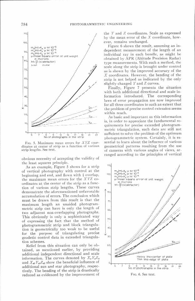
As an example, Figure 5 shows for a stripof vertical photography with control at thebeginning and end, and flown with j overlap,the maximum mean errors for the X YZ coordinates at the center of the strip as a function of various strip lengths. These curvesdemonstrate the aforementioned unfavorableaccumulation of errors. The conclusion whichmust be drawn from this result is that themaximum length an unaided photogrammetric strip can have is only the length oftwo adjacent non-overlapping photographs.This obviously is only a sophisticated wayof expressing the fact that the method ofphotogrammetric strip and block triangulation is geometrically too weak to be usefulfor the purpose of triangulating precisegeodetic control data in extended triangulation schemes.
Relief from this situation can only be obtained, as mentioned earlier, by providingadditional independent directional and scaleinformation. The curves denoted by X. Y.Z.and X.e Y.tZ.t show the beneficial influence ofadditional sun and star photography, respectively. The bending of the strip is drasticallyreduced as evidenced by the improvement of
the Y and Z coordinates. Scale as expressedby the mean error of the X coordinate, however, remains unchanged.
Figure 6 shows the result, assuming an independent measurement of the length of anindividual ray in each bundle, as might beobtained by APR (Altitude Precision Radar)type measurements. With such a method, thescale along the strip is brought under controlas is shown by the improved accuracy of theX coordinates. However, the bending of thestrip is not helped as indicated by the onlyslightly changed Yand Z curves.
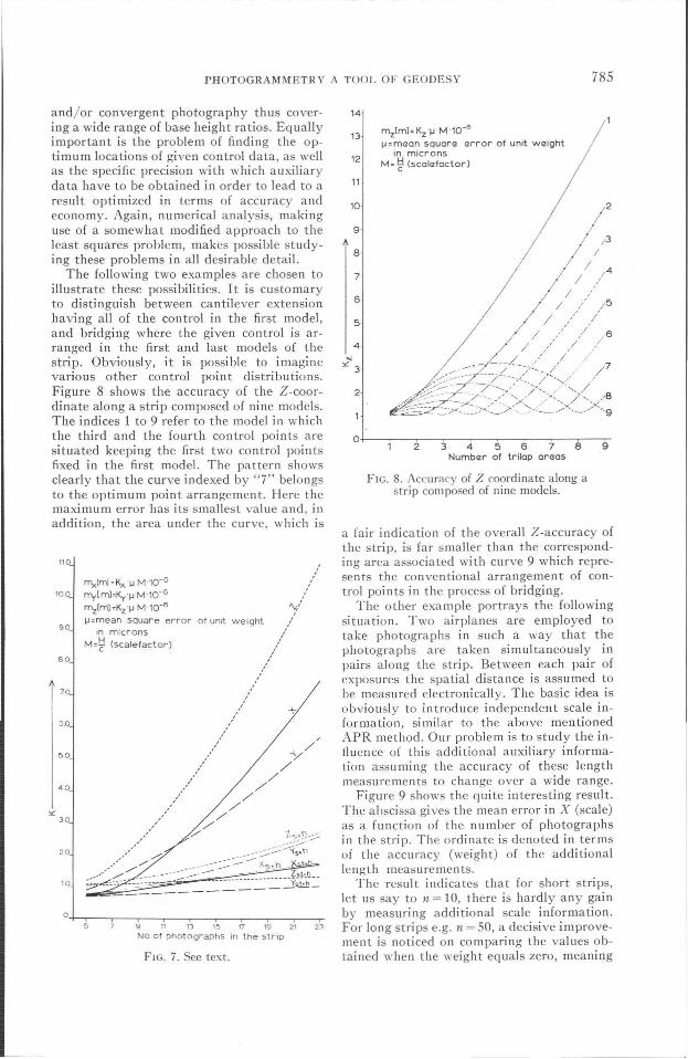
Finally, Figure 7 presents the situationwith both additional directional and scale information introduced. The correspondinglaws of error propagation are now improvedfor all three coordinates to such an extent thatthe problem of precise control extension seemswithin reach.
As basic and important as this informationis, in order to appreciate the fundamental requirements for precise extended photogrammetric triangulation, such data are still notsufficient to solve the problem of the optimumphotogrammetric system. Certainly, it is essential to learn about the influence of variousgeometrical patterns resulting from the useof cameras with various angles of views, arranged according to the principles of vertical
mx[mJ=Kx "~"M "10- 6
mylml=Ky"WM "10-6
mzlmJ= Kz"WM "10-6
.... =mean square error of unit weightin microns
M= -'t (scalefactor)
Heavy hncz=canter of platQ:Thin lin", ="'dg", of plot,z
O,+-c-.--C"""""T---r-.--r-.--,.....,r-r---r-.--r-.-.--r-r~5 9 11 13 15 17 19 21 23
No" of photooraphs in the strip
FIG. 6. See text.
PHOTOGRAMMETRY A TOOL OF GEODESY 785
0.+--,--_-.-_-,-_,--_.,-_,-----,,.---,_--,_-,.-
F1G. 7. See text.
5 9 11 13 15 17 19 21 2)
No. of photographs in the strip
m z[mJ:KZ 'WM'10-6
~: maon squora arror of unit waightin microns
M: ~ (scala foetor )
4
6
5
2
7
8
9
11
13
12
14
10
FIG. 8. Accuracy of Z coordinate along astrip composed of nine models.
N
" 3
o+--,.-~-~-~-.,.--~~--,----,23456789
Numbar of trilop araas
a fair indication of the overall Z-accuracy ofthe strip, is far smaller than the corresponding area associated with curve 9 which represents the conventional arrangement of control points in the process of bridging.
The other example portrays the followingsituation. Two airplanes are employed totake photographs in such a way that thephotographs are taken simultaneously inpairs along the strip. Between each pair ofexposures the spatial distance is assumed tobe measured electronically. The basic idea isobviously to introduce independent scale information, similar to the above mentionedAPR method. Our problem is to study the influence of this additional auxiliary information assuming the accuracy of these lengthmeasurements to change over a wide range.
Figure 9 shows the quite interesting result.The abscissa gives the mean error in X (scale)as a function of the number of photographsin the strip. The ordinate is denoted in termsof the accuracy (weight) of the additionallength measuremen ts.
The result indicates that for short strips,let us say to n = 10, there is hardly any gainby measuring additional scale information.For long strips e.g. n = 50, a decisive improvement is noticed on comparing the values obtained when the weight equals zero, meaning
""Iml :Kx '~'M'10-G
my(ml:KY"~'M'1O-6
mz(ml:Kz'~'M'10-6
lJ=mean square errorin microns
M:~ (scale/actor)
10
20
6.0
110
50
gO
40
80
'00
and/or convergent photography thus covering a wide range of base height ratios. Equallyimportant is the problem of finding the optimum locations of given control data, as wellas the specific precision with which auxiliarydata have to be obtained in order to lead to aresult optimized in terms of accuracy andeconomy. Again, numerical analysis, makinguse of a somewhat modified approach to theleast squares problem, makes possible studying these problems in all desirable detail.
The following two examples are chosen toillustrate these possibilities. It is customaryto distinguish between cantilever extensionhaving all of the control in the first model,and bridging where the given control is arranged in the first and last models of thestrip. Obviously, it is possible to imaginevarious other control point distributions.Figure 8 shows the accuracy of the Z-coordinate along a strip composed of nine models.The indices 1 to 9 refer to the model in whichthe third and the fourth control points aresituated keeping the first two control pointsfixed in the first model. The pattern showsclearly that the curve indexed by "7" belongsto the optimum point arrangement. Here themaximum error has its smallest value and, inaddition, the area under the curve, which is
" 30

PHOTOGRAMMETRIC ENGINEERING
m [mJ=K ·~·M·1O-6
...=~aan ";quara arror of unit w12ight in microns
M=~ (scalQ:factor)
786
00
1000
100
r1.0
.1
n.....01
.001
.0001
05 20
50
25KX--------~
FIG. Q. Abscissa-mean error in X (scale) as a function of number of photographs in the strip. Ordinateterms of accuracy (weight) of the additional length measurement.
that the auxilary quantity is not measured atall, with the values obtained when the weightequals 00, indicating a flawless measurementfor the additional lengths. The really significant information, however, is (a) that inaccurate length measurements do not contribute much; (b) that an area exists which isgreatly benefited by a slight increase in accuracy of the corresponding length measurements, and finally (c) that there is a verydefinite optimum level for the accuracy of thelength information. Any further improvement of the length measurements does notlead to any additional gain in the accuracyof the triangulation result.
I t is hardly necessary to stress the importance of this type of information when itcomes to optimizing the planning and instrumentation of any specific measuringsystem.
The examples and the explanations havehad to be short in order to fit the allottedtime of this presentation. I hope they havebeen elaborate enough to support the following concluding remarks:
Photogrammetry has, at least in my opinion, the potential of assisting in the establishment of precise geodetic control data. Inorder to meet the resulting accuracy requirement, photogrammetry has to make an effortto develop from an engineering tool-a termused with highest regard-to an exactingmensuration technique. Numerical analysis,possible by electronic computing, allows oneto investigate any anticipated triangulationsystem in order to optimize the necessary
instruments as well as the geometry of thetriangulation, for satisfying certain a prioriestablished accuracy requirements. Thus theperformance requirements obtained for thecorresponding measuring instruments willenable the photogrammetric engineer to confront the industry with unambiguous demands for essential measuring equipment.From results already available, it is clearlyindicated that a precision triangulation method will depend on the availability of hybridsystems, combining angular and length measuring devices, under optimum conditionswhich can be determined by correspondingnumerical investigations.
Again, making use of the potential ofnumerical evaluation methods, the individualcomponents of such instrumentation have tobe investigated. If they have been found tobe consistent with the pre-established accuracy requirements, the execution of precise photogrammetric triangulations will thenin essence become a problem of logistics andorganization. Thus, it will be possible toguarantee a certain amount of information inaccordance with a planned amount of effort.
Those who feel such an approach too extreme have to realize that photogrammetryhas already committed itself in connectionwith certain space projects, especially in connection with the geodetic satel1ite, to the support of complex triangulation projects, theresults of which will only be acceptable ifthey can withstand the most critical scrutinyas dictated by the principles governing exactmeasurements.