predictingreservoirarchitecture*indeep … preamble*...
TRANSCRIPT

1
Predicting Reservoir Architecture in Deep-‐water Systems (PRAX-‐2)
EXECUTIVE SUMMARY This proposal consists of a unique combination of digitally-‐based outcrop studies, and oceanographic studies of modern systems, combined with a decade of previous research including state-‐of-‐the-‐art numerical modeling, to understand deep-‐water depositional systems and their resulting reservoir architecture and properties. Earlier research has focused on: coarse-‐grained channel systems and their overbank deposits (terraces and levees), and seismic modeling of their architectures; numerical modeling of overbank flow processes; and ponded slope accommodation related to mass transport deposits. The results of this earlier research will form the foundation to the present study, and will be available to sponsors. The present study extends the scope into a more holistic view of deep-‐water systems, via new field studies, the main focus of which will be:
• sheet-‐like sand bodies (lobes, splays and confined/ponded sheets) • diversity of channel fills and their overbanks • impact of mass transport on reservoir development
Deliverables In addition to new proprietary models and data, outputs will include extensive hierarchical reviews of deep-‐water depositional elements and processes, incorporating the results of our earlier research and integrating it with the existing published literature; the project results will be progressively incorporated as the research proceeds. This will provide a comprehensive overview for those not well versed in deep-‐water sedimentology and stratigraphy, or for those seeking an up-‐to-‐date refresher. One of the main challenges that sponsors have with JIPs is figuring out how to apply the outcomes in the subsurface. To this this end, in addition to the deepwater subject reviews, we will develop workflows that the end user can apply to their own prospects or fields, including not only the learnings from our own research but also as much as possible of our experience in the analysis and application of background knowledge to deepwater systems in the subsurface.The project will also include at least one training trip annually to one of the field areas of the project. The project will thus provide training and education opportunities for sponsors.

2
PREAMBLE Profitability in today’s highly challenging environment depends more than ever on recovery efficiency. Of the principal factors that impact recovery, sweep is the most dependent upon a proper geological understanding of the architecture and structure of the reservoir. In depositional settings as complex and variable as deep water it is virtually impossible to be entirely deterministic about the sedimentary architecture. It is, however, possible to constrain the range of possibilities (and their associated reservoir properties) based upon a comprehensive understanding of deep-‐water systems that draws on integration of outcrop analogue work, studies of modern deep-‐water depositional systems, laboratory experiments and computational fluid dynamics. This can result in some surprises, such as the likelihood that well over half the net sand in slope channel systems is contained within thin beds with potentially predictable distributions. It also emphasizes the value of input from the appropriate disciplines (sedimentologists/stratigraphers) at the right time. Unlike the majority of depositional systems, modern deep-‐water environments are difficult and expensive places in which to make direct observations of depositional architecture and process. Consequently predicting reservoir occurrence (at exploration scale), and reservoir architecture and properties (at production scale) are dependent on the use of multiple analogues and models, and prone to a high degree of uncertainty. Generating such models, and fully understanding their meaningful application and the surrounding uncertainty, requires an integrated approach utilizing multiple techniques and data types. By combining outcrop data; shallow (high resolution) seismic data; conventional industry seismic data; marine geology (coring, multichannel seismic and swath bathymetry), and numerical modeling, we bring a uniquely integrated approach to the understanding of deep-‐water systems. The Principal Investigators have between them almost 150 years of cumulative deepwater experience, have participated in over 40 research cruises, and have decades of involvement with industry via research consortia, consultancy and training. PROJECT THEMES & DELIVERABLES The PRAX-‐2 JIP proposal builds on a rich 10-‐year legacy of studies on all of the major reservoir components in slope systems. The project will add additional field studies (see Annex). However the key for PRAX-‐2 is to integrate all of this past and current data into formats that make it easy for any geoscientist or engineer to access the information in an easy and practical way. The fundamental elements of this are the following. Topic reviews will provide hierarchical online summaries of knowledge on each element of deep-‐water systems, reviewing and condensing both our own JIP data and published work, including outcrop analogues, observations and interpretations from typical subsurface data sets (seismic, well logs, cores), and syntheses of stratigraphic and facies models, highlighting common themes and uncertainties, ranging from one-‐page ‘abstracts’, via increasing levels of detail, to – at the deepest level -‐ the results of our own studies.

3
Workflows will provide guidance to the description and interpretation of the significant facies which contain and control the distribution of reservoirs (practical hints and tips). It will incorporate comprehensive JIP work (especially outcrop analogues) to support and demonstrate the interpretation guidelines. Annual sponsors’ meetings will be held to deliver results via oral presentations and posters that will be available to sponsors via the web. Costs of holding sponsors’ meetings outside of Aberdeen will be divided pro-‐rata between attending sponsors. Training-‐oriented field-‐trips will be held when practical, in one of the field areas of the current or previous projects. These will be provided at cost, and the charges distributed pro-‐rata between attendees. Sponsors may wish to send delegates to observe or participate in fieldwork at their own cost. PRINCIPAL INVESTIGATORS Ben Kneller is a Professor in the Department of Geology and Petroleum Geology at University of Aberdeen, with over 30 years of deepwater experience and 23 years experience of leading Joint Industry Projects. Mike Mayall was formerly the leader of the sed/strat network within BP, and is now a consultant; he has over 30 years of subsurface experience. Bryan Cronin is an independent consultant and Honorary Professor at University of Aberdeen, with extensive experience in marine geology research, consultancy and training. Juan Pablo Milana is a Principal Researcher with CONICET (the Argentine national research council) and a faculty member at Universidad Nacional de San Juan, Argentina. Fabiano Gamberi is a Senior Scientist at Istituto de Scienze Marine in Bologna, leader of many research cruises, with extensive field geology experience. Ian Kane is a Reader at Manchester University, who until recently worked for Statoil in their deepwater group. Associated Researchers: Hasan Çelik (Firat University, Elazig, Turkey) Kemal Gurbuz (Cukurova University, Adana, Turkey) Eckart Meiburg (University of California, Santa Barbara, USA) Marzia Rovere (ISMAR, Bologna, Italy) COST AND TIMING The three-‐year project followed on from the previous Joint Industry Project (Predicting Reservoir Architecture in Channelised Slope Settings) that

4
terminated in March 2015. Entry may be phased to permit first payment in 2016. The cost will be £30k per year for new sponsors. Equivalent fees in euros or US dollars will be fixed at the exchange rate pertaining at the contract date. EXECUTION The work will be carried out by the the Principal Investigators, Post-‐doctoral Research Fellows and PhD students. Three of the PhD students and one post-‐doc are already in post, and an additional post-‐docs is due to begin work in April 2016. Extensive field infrastructure is already in place including our own 4-‐wheel drive vehicles in Argentina, Mexico and Turkey, and we have a large inventory of field equipment. Students will be expected to integrate data from various sources into their dissertations, including subsurface data provided by sponsor companies. They will be encouraged to undertake internships with sponsor companies as an additional means of technology transfer. ANNEX Fieldwork themes 1. Turbidite sheet systems. Many turbidite sandstone bodies consist of sheet-‐like beds of amalgamated sandstone or non-‐amalgamated alternations of sandstone with siltstone/mudstone, which may appear tabular on a small scale. On a reservoir scale the turbidites within these deposits possess architectures that are governed by at least four controlling parameters
• flow magnitude • sand/mud ratios • flow concentration • degree of confinement
The effects of the first three of these have been studied qualitatively in the field and experimentally in the laboratory, but models of the effects of flow confinement on architecture are not well developed. Frontal Splay Architecture In turbidite systems that are ‘underfit’ with respect to the topography (ie are unconfined) much of the sand is typically contained within frontal splays at the ends of channels. Sea floor and shallow seismic data splays show a bewildering variety of external geometries and stacking patterns for such frontal splays (Fig. 1), which fundamentally affect their reservoir properties, yet the internal architectures of these various different types of frontal splays are largely unknown. A major theme of PRAX-‐2 will be to compare different styles of frontal splay at outcrop, relate these to the various geometries observable in modern systems, and establish criteria for differentiating these in the subsurface. The Eastern and Western Fans in the Adana Basin (Fig. 2) are two large deep-‐water base-‐of-‐slope/basin floor fans formed during the early Miocene along a 70km exposed strike section of basin margin. The fans were fed by fan deltas during periods of rapid sea level fall. The deep-‐water sections, up to 2.5 km thick,

5
include 1.5km of sandstone-‐dominated fan dominated by frontal splays enveloped by sheet sandstones and shales (Fig. 3). Within these two fans, dramatic new road sections provide excellent cross-‐sectional exposures of the architecture of what are sheet like in general aspect, but consist of alternations of thin-‐bedded sheets and more pod-‐like frontal splays that are approximately 5 to 8m thick and 800 to 1,500 m wide. The distance from the feeder canyon and the lateral pinch-‐out against the adjacent slope is well known from previous work (e.g. Cronin et al, 2000; Satur et al, 2007). The Maras Basin in eastern Turkey is a Miocene foreland basin located three hours NE of the Adana Basin in southern Turkey. The Alikayasi and Tekir slope canyon-‐channel systems (partially studied in in the preceding Joint Industry Project) are bypass-‐dominated slope channel complexes on the northern basin margin, which fed through a channel-‐lobe transition zone (CLTZ) into a series of sheet systems, including frontal splays, that alternate with mass transport deposits and thin-‐bedded turbidites (Fig. 4). The sheet systems of the Maras Basin complement those of the Adana Basin frontal splays, in that they show a variety of layered and amalgamated geometries that build into our conceptual descriptional framework for non-‐channelised turbidite systems. Mapping of the sheet complexes will be completed within the framework of PRAX-‐2. Defining frontal splay architecture, compensational stacking, connectivity, frequency of splay avulsion and its causes, and the downslope transitions are all themes of this part of the study. Work will be supported locally by Dr Hasan Celik (Firat University, Elazig) and Professor Kemal Gurbuz (Cukurova University, Adana). Confined/unconfined systems Early models for turbidite systems differentiated what are now commonly called basin-‐floor fans (Type II systems of Mutti & Normark, 1991) from laterally extensive and less amalgamated sheet systems (Type I systems of Mutti & Normark; Fig. 5). Mutti & Normark suggested that they might relate to different stages of a sea level cycle, but subsequent work seems to indicate that in fact truly sheet-‐like turbidite systems form when the turbidity currents are confined or contained within a small or narrow basin. Their bed geometry and overall architecture is a result of interaction between turbidity currents and the margins of the basin, and so depends both on the size of the basin and on the size of the flows. Exceptionally well-‐exposed sheet-‐like turbidite systems in the syn-‐ to post-‐glacial Pennsylvanian of western Argentina (Fig. 6) occupy basins ranging in scale from paleofjords, little more than a kilometer across (Jejenes Formation of San Juan province Fig. 7), to sub-‐basins of at least 10 km width (Guandacól Formation of La Rioja province; Fig. 8). They present a unique opportunity to compare and contrast the architectures resulting from differing degrees on confinement. These systems (which have been the subject of a substantial amount of earlier work under our supervision) will be compared with published

6
and unpublished data from other systems known to show various degrees of confinement at various scales, ranging from unconfined lobes/splays of the Permian Tanqua Karoo, via ponded mini-‐basins of the Alpine foreland basin to elongate foredeeps of the Eocene Hecho Group (northern Spain) and the Miocene Marnoso-‐Arenacea. We will focus particularly on issues of connectivity. With sufficient sponsors (8 or more) we will apply existing numerical models (direct numerical simulations partly developed under earlier collaboration with UC Santa Barbara) to simulate the changes in architecture with increasing confinement. Composite systems Many (if not most) laterally extensive sandy turbidite systems (lobes/splays and sheets) contain not only turbidites but also the deposits of other types of sediment gravity flow, including most commonly: debrites; mega-‐beds of various types; and hybrid beds consisting of the deposits of flows with some degree of non-‐Newtonian behavior – either combinations of co-‐genetic turbidite and debrite, or flows with behavior transitional between the two (e.g. Haughton et al., 2009) that generate ‘dirty’ matrix-‐rich sands; often these have a detrimental impact on reservoir properties. Debrites have been identified in the depositional lobes of several large submarine fans (Mississippi. Congo; Fig. 9), and are commonly interbedded with sandy or heterolithic turbidites in outcrop. The important question concerning reservoir architecture is: what determines bed stacking in composite systems, and how does the interbedding of deposits of different processes influence the overall stacking pattern? Systems built by a mix of processes will have different patterns to those consisting either solely of turbidites or of debrites, since each type of flow responds differently to the topography generated by the other. In this study we will not only draw on the results of PhDs previously supervised by the Principal Investigators to re-‐visit systems where such interaction is known to have occurred (e.g. the Oligocene Grès de Peira Cava in the Alpine foreland basin), but will undertake new studies in well-‐exposed mixed turbidite/debrite lobe deposits of Miocene age in the Maras and Adana basins in central Turkey (Fig. 2) that have been the subject of earlier reconnaissance studies. The Pennsylvanian Guandacól Formation of La Rioja province, western Argentina (Fig. 6), contain several types of hybrid flow deposits, which can be traced and correlated over several kilometres, providing constraints on models for the physical behavior of the parent flows. If funding permits we will use these constraints to develop numerical models for non-‐Newtonian flow behavior in partnership with our longstanding collaborators at University of California, Santa Barbara (UCSB), to better understand the generation and distribution of matrix-‐rich sands. Megabeds within sheet systems are the deposits of flows that are exceptionally large compared to the basin area, and are typically substantially thicker than

7
most other deposits in the same system. These often consist of a composite of turbidite/debrite , and typically have thick mud caps. Not only may these constitute good stratigraphic markers, but they can form reservoirs in their own right (North Sea Paleocene and Jurassic, e.g. Pauley, 1995); moreover the mudstones that typically cap these beds may form important intra-‐reservoir barriers. A comparative study of the range in and controls upon megabeds will be undertaken as part of the overall study of sheet-‐like systems, overseen by a post-‐doctoral researcher. Excellent examples exist within the Pennsylvanian Jejenes and Paganzo Formations (San Juan and La Rioja provinces respectively) in western Argentina (already partly studied by the post-‐doctoral candidate; Fallgatter, 2014; Fig. 10), but also in the Oligocene Grès de Peïra Cava, France (Amy et al., 2000), the classic Miocene Marnoso Arenacea, Italy (Lucente, 2004), and the Eocene Hecho Group, Spain (Labaume et el., 1987; Remacha et al., 2005). Insights from modern systems In the Tyrrhenian Sea (Fig. 11), the Capo d’Orlando basin plain (Fig. 12) is fed by multiple slope channels that build distinct lobes with various geometry of interfingering and overlapping portions. At the present day, some of the channels are connected with the coastal systems and are sites of turbidity currents, whereas others, stranded at the shelf edge away from any coastal systems, are fed only by mass transport deposits. The lobes are confined seaward by a volcanic slope and are also affected by subtle topography created by seafloor faulting. Preliminary analysis of cores show that some of the deposits can correspond to hybrid deposits due to various types of flow transformations. We have selected this area, already covered by an extensive integrated data set, to perform a comprehensive study of the multifaceted aspects of modern lobe development. With sufficient sponsorship (seven companies or more) the existing cores, bathymetric, sidescan sonar and sub-‐bottom data will be complemented with the acquisition of multichannel high resolution seismic lines and additional seafloor sampling. The integrated data set will allow our research to address both the processes at the scale of single flow units and the processes at the scale of thicker multi-‐flow depositional units. Issues that will be addressed are:
• facies, internal elements and geometry of lobes built by debris flows; • facies, internal elements and geometry of lobes built by turbidity
currents; • mutual relationships between mass transport and turbidite lobes; • debris flow lobe as potential sealing units of turbidite reservoirs; • internal heterogeneity of turbidite reservoirs; • thickness and facies variations imposed by seafloor topography; • assessment and quantification of the influence of seafloor topography on
the thickness and quality of reservoirs units; • hybrid beds character and distribution;

8
• channel-‐mouth deposits and their down-‐ and up-‐dip continuity; • temporal variations in stacking pattern and their linkage with auto-‐ and
allocyclic factors. 2. Channel diversity Previous work under the Slopes and PRACSS consortia has established the architectural patterns of bypass-‐dominated coarse-‐grained channel systems, and given some idea of their diversity. It is clear, however, that both fine-‐grained (sandy) channel systems and aggradationally-‐dominated coarse-‐grained systems possess architectures that are distinct from coarse-‐grained bypass-‐dominated systems. We propose comparative studies of both these types of channel systems to define end members of the submarine channel spectrum. Sandy slope channel fills The first element of this proposal is a field-‐based study of coastal exposures of deep-‐water channel-‐fill sandstones of the Oligo-‐Miocene Cabo Domingo Group of the Austral Basin, Argentina. The Cabo Domingo Group is exposed along the eastern coast of Tierra del Fuego (Fig. 13), and each cape reflects the presence of a sandy unit. A reconnaissance of two of these channel complexes (Cabo Viamonte and Cabo Ladrillero, Fig. 14a & b) suggests a range of fill styles from well-‐stratified (Cabo Viamonte) to more massive (Cabo Ladrillero). The more complex fills show large multi-‐storey channels with a complex history of relocalization of the active channel (cf Ponce et al., 2008). The fill of each channel usually begins with a thin coarser-‐grained unit, typically an intra-‐formational breccia. The main fill of the channel consists of medium to fine sand turbidites (Fig. 14a), with typical upward fining profiles. Some of the uppermost single channels contain a fill of finer-‐grained turbidites and hemipelagic muds suggesting channel abandonment (Fig. 14a). The main channel lateral boundary separates the channel body from a finer-‐grained levee-‐like package, passing laterally into more muddy sequences. The aim will be to develop a reservoir model for these types of channels, based on facies architecture and spatial variation of poroperm properties, as well as defining the role of different internal boundary surfaces in the compartmentalization of the reservoir. The work would be undertaken by Masters students at San Juan and a PhD student at Aberdeen. Part of the students´ work will be to explore the coast for additional channel complex styles. Aggradational versus by-‐pass dominated slope channels Coarse-‐grained slope channel systems have previously been described by some authors as if they all possessed similar architectures (e.g. Sprague et al., 2005), yet there are substantial differences in architecture and reservoir properties between the different systems that we have studied. For example, comparing two coarse-‐grained slope channel systems: the Maastrichtian San Fernando channel system of the Rosario Group (Baja California, Mexico; Dykstra & Kneller, 2007; Fig. 15a & b) has a single bounding surface, and the fill is dominated by multiple hierarchies of erosion surface (Fig 3c), separating depositional facies that are largely traction–dominated –
9
somewhat resembling gravelly fluvial deposits (Fig. 15d); ‘beds’ (related to individual depositional events) are impossible to define, so it is dominated by sediment bypass and reworking of coarse material as bed-‐load. By contrast the Santonian-‐Campanian Cerro Toro Formation of the Magellanes Basin, southern Chile (Fig. 16a), has no single master bounding erosion surface (Fig. 16c); each channel complex set (or storey) has its own bounding erosion surface, and the fill is dominated by laterally-‐persistent beds of graded clast-‐ to matrix-‐supported gravel and sand (Fig. 16d), many of which can be traced for at least hundreds of metres, as can the occasional thin-‐bedded intervals; the fill is thus dominated by aggradation. Nonetheless this system has previously been described in similar architectural terms (e.g. Beaubouef, 2004) to bypass-‐dominated systems, such as the Rosario Formation, yet it is startlingly different in reservoir terms. We will continue to evaluate the differences between and controls on these various slope channel styles, building an outcrop dataset for the Cerro Toro channel architectures similar to that which we have acquired for the Rosario (Mexico) and Alikayasi (Turkey) systems, in order to build more general models for slope channel architecture. Insights from modern systems Multibeam bathymetric coverage is available on many of the modern slope channels of the Tyrrhenian Sea (central Mediterranean). The slope channels are located both along a passive (Sardinian area) and an active (Sicilian area) margin. With sufficient sponsorship we shall examine the internal elements of the different slope channels. The analysis will be aimed at a quantitative investigation, relying on property data that allow for direct measurement of the observed features. Furthermore, it will complement and augment the significance of the result of the on-‐going review of internal channel elements worldwide from literature examples. In particular, the range of diverse intra-‐channel elements will be examined and linked with their possible genetic processes with the aim of developing tools for predicting the distribution of internal elements within slope channels. The comparison with ancient systems will be carried out to decipher the impact of intra-‐channel features on the character of the resultant channel infill. Long profiles of the different channel systems will be reconstructed and tied to longitudinal variations in internal element distribution to evaluate possible predictive tools linking channel architecture with gradient and planform. In large parts of the Tyrrhenian Sea, the multibeam bathymetric data also covers the continental shelf and the coastal areas, allowing the observation of the linkage between the slope channels and their feeding systems. The effects of the variable character of the source areas and of the mechanisms of slope sediment delivery on channel architecture will be determined. Sampling of slope channel infill is a difficult task due to the sandy or coarser nature of their infill. However, in the area of the Capo d’Orlando Basin, site of a dedicated cruise (with sponsorship by seven or more companies) we shall select
10
at least one slope channel where we can perform a coverage of box coring sampling (shallow recovery). The final results will consist of the reconstruction of the distribution of surficial facies within channel infill and will allow a preliminary ground-‐truthing of the different internal architecture elements of slope channels. 3. Mass transport deposits: Impact on reservoir. Mass transport deposits (MTDs) are one of the most poorly understood elements of continental slope systems. They may constitute up to 50% or more of the succession, and although they are routinely imaged in high-‐resolution 3D seismic data volumes. We have previously developed models for the distribution of partially ponded sands above MTDs and their length scales, but such sands may be difficult to recognize and predict in the subsurface. Mass movements may, in some circumstances, glide over a basal slide surface with little or no effect on the underlying stratigraphy (Fig. 17). In other cases they may have a profound effect on the underlying stratigraphy (including reservoir), either by removing substantial amounts of material and incorporating it into the moving mass (Figure 18), or by transmitting strain downwards into more or less in situ stratigraphy below the basal slide surface, and disrupting it. It may be hard to differentiate in situ material from the MTD. Superb examples of seismic-‐scale (>100m thick) MTDs occur at outcrop in western Argentina (Carboniferous Guandacól Formation near Villa Union, La Rioja Province), some of which have been the subject of study by our group over recent years, while other exposures have become accessible as fresh road cuts (Guandacól Formation in La Peña Canyon, San Juan Province). The project will examine the various components of the MTD play including : 1) MTD itself, 2) ponded sands, 3) trailing-‐piggyback mini-‐basins. Our ongoing work on ponded supra-‐MTD sands has elucidated some of the controls on the MTD topography that creates accommodation for turbidite sands (e.g. Fairweather 2014), but it is not yet clear how variations in the nature of the turbidity currents affect the filling of this topography. We will continue to investigate the variation in fill style above MTDs using field examples from the Paganzo Group, and if funding permits, to apply high-‐resolution numerical models to the interaction of turbidity currents with the surface topography of MTDs (e.g. Nasr-‐Azadnai & Meiburg, 2011; Tokyay et al., 2011) Modern systems We will develop models out of the extensive dataset of modern submarine landslides from existing seismic lines and bathymetry data on the modern seafloor in the Tyrrhenian Sea. This work will add information on a) the styles of MTD topography observed in a range of depositional settings and b) define predictive trends based on the extraction of digital elevation models of the upper surfaces of MTDs and the 2D power spectra analysis (supplementing work done under a previous JIP; Fairweather, 2014). This will help to detect patterns and tendencies for sea-‐floor topography alteration and thus, subsequent ponding.

11
The methodology thus developed will be then used to evaluate subsurface MTDs in order to search for similar signals. With sufficient sponsorship new data will collected during the oceanographic cruise, and will be studied to evaluate the geometry of basal shear surfaces and their eventual potential to act as a seal for potential reservoirs. The make-‐up of mass-‐transport-‐complexes and their relationships with interbedded turbiditic units will also be addressed. References Amy, L., Kneller, B.C. & McCaffrey, W.D., 2000. Evaluating the links between turbidite characteristics and gross system architecture: upscaling insights from the turbidite sheet system of Peira Cava, SE France. In in Weimer, P., Slatt, R.M., Coleman, J., Rosen, N.C., Nelson, H., Bouma, A.H., Styzen, M.J., and Lawrence, D.T., eds., Deep-‐water reservoirs of the world . SEPM Gulf Coast Section, Houston, 1-‐15. Beaubouef, R.T., 2004. Deep-‐water leveed-‐channel complexes of the Cerro Toro Formation, Upper Cretaceous, southern Chile. AAPG Bulletin, 88, , 1471–1500. Cronin, B.T., Hurst, A., Celik, H. & Türkmen, I., 2000. Superb exposure of a channel, levee and overbank complex in an ancient deep-‐water slope environment. Sedimentary Geology, 132, 205-‐216. Dykstra, M.& Kneller, B., 2007. Canyon San Fernando, Mexico: A Deep-‐water, Channel-‐levee Complex Exhibiting Evolution from Submarine Canyon — Confined to Unconfined. In Nilsen, T, Studlick, J. & Steffens G., Atlas of Deepwater Outcrops, Studies in Geology, 56. American Association of Petroleum Geologists, Tulsa, 226-‐230. Fairweather, L., 2014. Mechanisms of supra MTD topography generation and the interaction of turbidity currents with such deposits. University of Aberdeen, PhD thesis (unpubl.). 243pp. Fallgatter, C., 2014. High resolution stratigraphy in gravity-‐flows systems of Paraná (Brazil) and Paganzo (Argentina) basins. Universidade do Vale do Rio Sinos. MSc thesis (unpubl.). 159pp. Haughton. P., Davis, C., McCaffrey, W. & Barker, S., 2009. Hybrid sediment gravity flow deposits – Classification, origin and significance. Marine and Petroleum Geology, 26, 1900–1918. Labaume, P., Mutti, E. & Séguret, M., 1987, Megaturbidites: a depositional model from the Eocene of the SW-‐Pyrenean foreland basin, Spain: Geo-‐Marine Letters, 7, 91–101.
12
Lucente, C.C., 2004. Topography and palaeogeographic evolution of a middle Miocene foredeep basin plain (Northern Apennines, Italy). Sedimentary Geology, 170, 107–134. Mutti, E., & Normark, W. R. (1991). An integrated approach to the study of turbidite systems. In P. Weimer, & H. Link (Eds.), Seismic facies and sedimentary processes of submarine fans and turbidite systems, Ann Arbor (pp. 75–106). New York: Springer. Nasr-‐Azadnai, M.M. & Meiburg, E., 2011. TURBINS: An immersed boundary, Navier–Stokes code for the simulation of gravity and turbidity currents interacting with complex topographies. Computers & Fluids, 45, 14–28. Olivero, E.B. and Malumián N. 2008, Mesozoic-‐Cenozoic stratigraphy of the Fuegian Andes, Argentina. AAPG Hedberg Research Conference: Sediment Transfer from Shelf to Deepwater -‐ Revisiting the Delivery Mechanisms. Ushuaia, Field Guide Book, p.9-‐24. Pauley, J.C., 1995. Sandstone megabeds from the Tertiary of the North Sea. In Hartley, A. J. & Prosser, D. J. (eds), 1995, Characterization of Deep Marine Clastic Systems, Geological Society Special Publication No. 94, 103-‐114 Remacha. E., Fernández, L.P. & Maestro, E., 2005. The transition between sheet-‐like lobe and basin-‐plain turbidites in the Hecho basin (south-‐central Pyrenees, Spain). Journal of Sedimentary Research, 75, 798–819. Satur, N., Hurts, A., Kelling, G., Cronin, B.T. et al, 2007. Components of feedetr systems to a deepmarine fan, Miocene ages Cingoz Fm, Soutehrn Turkey, In Nilsen, T, Studlick, J. & Steffens G., Atlas of Deepwater Outcrops, Studies in Geology, 56. American Association of Petroleum Geologists, Tulsa. Tokyay, T., Constantinescu, G. & Meiburg, E., 2011. Tail structure and bed friction velocity distribution of gravity currents propagating over an array of obstacles. Journal of Fluid Mechanics, 694, 252_291.

‘LOBE’'
Figure 1. Potential range of frontal splay styles
Figure 2. Location map for Adana Basin (red) and Maras Basin (blue)

Figure 3. Alternating frontal splay (5-‐8m thick) and splay fringe deposits, Eastern Fan, Adana Basin (photo courtesy of Alessandro Amato)
Figure 4. Alternating mass transport deposits and layered/amalgamated sheet complexes within the Tekir System, Maras Basin (photo courtesy of Alessandro Amato)
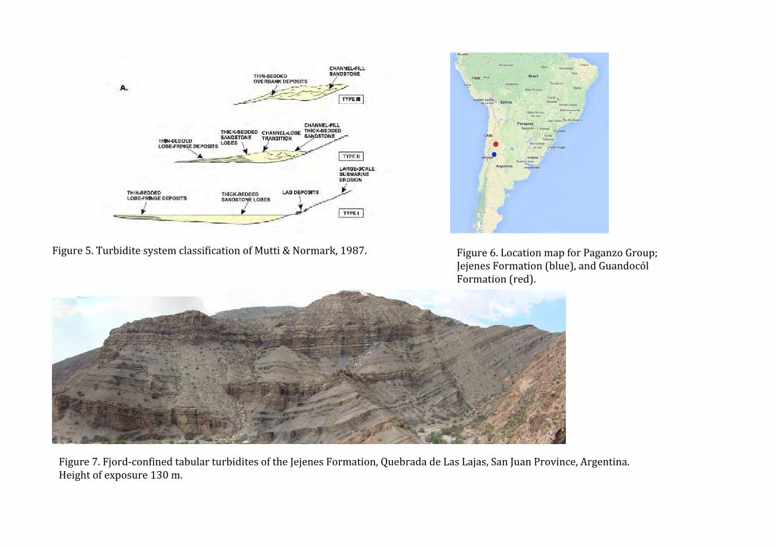
Figure 5. Turbidite system classification of Mutti & Normark, 1987.
Figure 6. Location map for Paganzo Group; Jejenes Formation (blue), and Guandocól Formation (red).
Figure 7. Fjord-‐confined tabular turbidites of the Jejenes Formation, Quebrada de Las Lajas, San Juan Province, Argentina. Height of exposure 130 m.

Figure 8. Basin floor turbidites of the Guandocól Formation, Cerro Bola, La Rioja Province, Argentina. Left; typical exposure; height of cliff c.100m. Right: correlation over 8 km (from Fallgatter, 2014)
Figure 9 Deep-‐tow side-‐scan sonar image of debris flow deposits on the surface of a modern lobe of the Congo Fan , from Savoye, 2009.
B
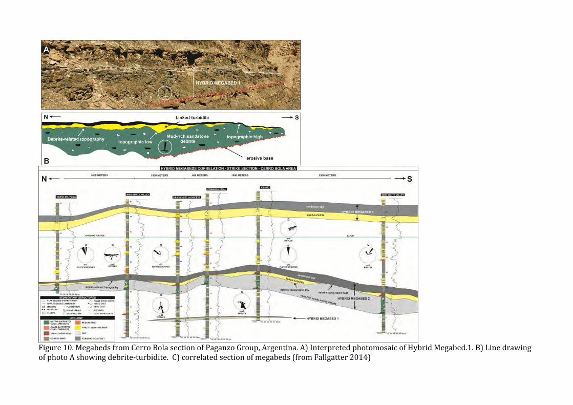
Figure 10. Megabeds from Cerro Bola section of Paganzo Group, Argentina. A) Interpreted photomosaic of Hybrid Megabed.1. B) Line drawing of photo A showing debrite-‐turbidite. C) correlated section of megabeds (from Fallgatter 2014)

Figure 11 Regional map of Capo d’Orlando Basin area, Tyrrhenian Sea, showing core locations, seismic lines and seismicity.

Figure 12 Depositional element map of the Capo d’Orlando Basin area.
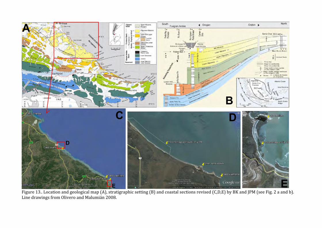
Figure 13.. Location and geological map (A), stratigraphic setting (B) and coastal sections revised (C,D,E) by BK and JPM (see Fig. 2 a and b). Line drawings from Olivero and Malumián 2008.

Figure 14A. Photomontage taken walking along a coastal tidal flat of Cabo Viamonte, see Fig. 1 for location. Note that there is a main channel below that becomes fragmented into two main arms (A and B), while the sediment fill becomes finer grained, better stratified and less massive.

Figure 14B: Similar to Fig 2A, a channel in Cabo Ladrillero, but in this case not composite, quite massive and its geometry altered by a significant amount of sand injections
Figure 15A (left) Location map of Canyon San Fernando, Rosario Formation, Baja California, Mexico. Figure 15B (right) Composite cross section of the San Fernando channel system.

Figure 15C. Architecture of the lower part of a channel complex set within the San Fernando channel system.
Figure 15D. Typical tractional (bypass-‐related) fabric of the San Fernando channel system.

incised and steep composite eastern margin
amalgamated axis contemporaneous thin beds
2.5 km
Figure 16A (above left). Location map for Cerro Toro Formation. Figure 16B (above right) composite cross section of a channel body
Figure 16 C) (left) Architecture of axial part of channel system. Length of log is 15m. D) (right) 5m thick graded gravel bed representing a single flow.

4Figure 17. Mass transport deposit within Paganzo Group, La Peña Canyon, showing only minimal basal interaction with subjacent strata of hemipelagic siltstone. Height of outcrop approximately 7 meters.
Figure 18 A) blocks of substrate incorporated into mass transport deposit due to grooving of basal contact; Paganzo Group, Cerro Bola. Thickness of MTD approximately 140 meters.

Figure 18 B) Grooves in the substrate below the basal scar of a near-‐surface mass transport deposit; offshore Trinidad. Width of view c. 3 km
Figure 18 C) Grooves carved in the sea-‐floor beneath a frontally-‐emergent near-‐surface mass transport deposit, offshore Brazil. Width of view c. 35 km. Image courtesy of K. Garyfalou.