preliminary geologic map of mount pagan volcano, … · preliminary geologic map of mount pagan...
TRANSCRIPT

PRELIMINARY GEOLOGIC MAP OF MOUNT PAGAN VOLCANO, PAGAN ISLAND, COMMONWEALTH OF THE NORTHERN MARIANA ISLANDS By Frank A. Trusdell1, Richard B. Moore2, and Maurice K. Sako11Hawaiian Volcano Observatory, Hawaii National Park, Hawaii 96718; [email protected] 2US Geological Survey, Tucson, Arizona 95704 Prepared in cooperation with the Emergency Management Office, Commonwealth of the Northern Mariana Islands
Open-File Report 2006-1386
2006 U.S. Department of the Interior U.S. Geological Survey This report is preliminary and has not been reviewed for conformity with U.S. Geological Survey editorial standards. Any use of trade names is for descriptive purposes only and does not imply endorsement by the U.S. Government.

INTRODUCTION
GEOLOGIC SETTING
Pagan Island is the subaerial portion of two adjoining Quaternary stratovolcanoes near
the middle of the active Mariana Arc, north of Saipan (fig. 1). Pagan and the other volcanic
islands that constitute part of the Arc form the northern half of the East Mariana Ridge, which
extends about 2-4 km above the ocean floor. The > 6-km-deep Mariana Trench adjoins the East
Mariana Ridge on the east, and the Mariana Trough, partly filled with young lava flows and
volcaniclastic sediment, lies on the west of the Northern Mariana Islands (East Mariana Ridge;
Tanakadate, 1940; Hess, 1948; Karig, 1971; Karig and others, 1978; Banks and others, 1984).
The submarine West Mariana Ridge, Tertiary in age (Kroenke and others, 1981), bounds the
western side of the Mariana Trough. The Mariana Trench and Northern Mariana Islands (East
Mariana Ridge) overlie an active subduction zone where the Pacific Plate, moving northwest at
about 10.3 cm/year, is passing beneath the Philippine Plate, moving west-northwest at 6.8
cm/year (Simkin and others, 1989). Beneath the Northern Mariana Islands, earthquake
hypocenters at depths of 50-250 km identify the location of the west-dipping subduction zone,
which farther west becomes nearly vertical and extends to 700 km depth (Katsumata and Sykes,
1969). During the past century, more than 40 earthquakes of magnitude 6.5-8.1 have shaken the
Mariana Trench (National Earthquake Information Center, unpub. data).
The Mariana Islands form two sub-parallel, concentric, concave-west arcs (fig. 1). The
southern islands comprise the outer arc and extend north from Guam to Farallon de Medinilla.
They consist of Eocene to Miocene volcanic rocks and uplifted Tertiary and Quaternary
limestone (Gilbert Corwin, unpub. data, 1971). The nine northern islands extend from Anatahan
to Farallon de Pajaros and form part of the inner arc. The active inner arc extends south from
Anatahan, where volcanoes, some of which are active, form seamounts west of the older outer
arc (fig. 1; Karig, 1971; Stern and Bibee, 1984). Other volcanic seamounts of the active arc
surmount the East Mariana Ridge in the vicinity of Anatahan and Sarigan and north and south of
Farallon de Pajaros (Karig, 1971). Six volcanoes (Farallon de Pajaros, Asuncion, Agrigan,
Mount Pagan, Guguan, and Anatahan) in the northern islands have erupted during the past
2

century (Tanakadate, 1940; Trusdell and others, 2005), and Ruby Seamount erupted in 1996
(R.Y. Koyanagi, unpub. data).
Figure. 1. Regional map of the Mariana Islands and outline of the adjacent Mariana Trench. The Commonwealth of
the Northern Mariana Islands extends from Rota in the south to Uracas in the north.
3

PREVIOUS INVESTIGATIONS
Despite centuries of settlement, few detailed studies have been made of the geology and
historic eruptive activity of Mount Pagan. A few eruptions were reported as early as the 1600s; a
large eruption was reported in 1872–73, and relatively minor activity was noted during the
1920s. After the United States annexed the Marianas in the aftermath of World War II, Corwin
and others (1957) assessed the geology of Pagan Island and constructed a geologic map
distinguishing different rock types, like tuff, clinker ‘a‘ā, pāhoehoe, and cinders, partly on the
basis of their suitability as construction materials.
The large Plinian eruption of Mount Pagan on May 15, 1981, resulted in the evacuation
of Pagan residents (Banks and others, 1984). Intermittent ejection of mainly phreatic ash and
other products continued for another 15 years. The U.S. Geological Survey operated two
seismometers on the island, chiefly during the 1990s and in 2001, but, at present, there is no
continuous monitoring.
CLIMATE
The climate of Mount Pagan is dominated by northeast trade winds, which bring frequent
heavy showers during much of the year, except in late spring and early summer. Typhoons and
tropical storms are common in the Northern Mariana Islands, especially from August to
December. Average annual rainfall on Pagan is about 178-203 cm (70-80 inches; Corwin and
others, 1957).
STRUCTURE AND MORPHOLOGY
Rocks erupted by Mount Pagan cover an area of about 8 km in a north-south direction by
6 km west-east. A 5.5-km-diameter (fig. 2), roughly circular caldera, with a prominent southern
wall and more subdued, partly buried northern and eastern scarps includes more than half of the
subaerial part of Mount Pagan. Preliminary calculations of the volume of the volcanic edifice
that occupied the remnant caldera are ~4.7 to 5.8 km3. This implies that the caldera-forming
4

eruption was large and, at least, a VEI 5 (Newhall and Self, 1982; Mt St. Helens in 1980 was a
VEI 5). Mount Pagan itself rises to an elevation of 570 m near the center of the caldera. On the
western flank of Mount Pagan is a roughly 2 x 2-km depression with a lake in its floor (fig. 2).
The deposits surrounding the depression are characteristic of phreatomagmatic eruptions. We
interpret this feature as a maar.
Figure 2. North Pagan map showing the boundaries of the caldera and maar.
5

6
We have obtained about a dozen radiocarbon ages from charcoal collected beneath lava
flows and within pyroclastic deposits. An age of 10,780 ± 250 years B.P. for a lava flow near
the base of the southwestern caldera wall suggests that most of the stratigraphic succession
above it, including the presumed caldera-forming unit, is Holocene in age. Most of our new age
determinations are only a few hundred years old, suggesting that Mount Pagan has erupted
frequently and grown rapidly since caldera formation, probably less than 1,000 years ago.
Hence, it must be regarded as a potentially dangerous volcano.
Erosion has not been as prominent on Mount Pagan as it has been on some other islands
in the chain, perhaps due to the many lava flows and a lower abundance of loose pyroclastic
materials. However, localized erosion has been prominent in large drainages that head on the
western upper flank of Mount Pagan and flow southwestward into Shomushon village.
Unfortunately, the village has been mostly destroyed by flooding and debris flows after the 1981
eruption.
RADIOCARBON DATA
This report includes 10 radiocarbon ages from 3 eruptive units (table 1). Most of the
ages are Accelerator Mass Spectrometer ages generated in the U.S. Geological Survey’s
laboratory in Reston, Virginia. In addition, two ages were obtained from other laboratories. All
ages are reported in radiocarbon years before present (yr B.P., before the calendar year datum of
A.D. 1950). The variance is reported as one standard deviation, in years.
Carbonized roots, twigs, or vegetative litter formed most samples; rarely, unaltered wood
was used. Each age was calibrated to calendar years using CALIB 4.0 Radiocarbon Calibration
Program (Stuiver and others, 1998). The calibrated ages are for two standard deviations. The
data in column Table 1 labeled “Age range” encompasses the entire age range of calendar ages
possible for a given radiocarbon age. Symbols indicating quality show usefulness of age in
stratigraphic interpretations: +, age thought meaningful; 0, age probably meaningful but
accuracy may be far poorer than indicated by the reported precision; -, age meaningless (owing
to large analytical error) or incorrect (on the basis of our knowledge obtained by all ages and
regional stratigraphic relationships). Meaningless ages are not reported in Table 1.

7
Table 1. R[All ages are rep roots, t
Qbp5Qbp5Qbp5Qbp5Qbp5Qbp5Qaf29Qbf3Qbp5Qbp5
1Age grou
2Quality: '(large an3Calibrated4Each age w standar5Datum, W
Unit Lab
Table 1. Radiocarbon ages of samples from North Pagan, CNMI. [All ages are reported in radiocarbon years before present (yr B.P., before the calendar year datum of A.D. 1950). The variance is reported as one standard deviation in years. Materials dated include charcoal, roots, twigs, vegetative litter, or unaltered wood
adiocarbon ages of samples from North Pagan, CNMIorted in radiocarbon years before present (yr B.P., before the calendar year datum of A.D. 1950). Materials dated include charcoal,
wigs, vegetative litter, or unaltered wood (rarely).]
1 + TM-01-05c WW 3687 235 35 1524 to 1952 N Pagan N Coast on beach 18.16574 145.78893 101 + TM-01-11 WW 3692 235 35 1524 to 1952 Inland lake and coast 18.13737 145.77080 1200 - TM-01-09c WW 3690 50 35 1693 to 1955 West of inner lake 18.13724 145.77408 1201 + TM-01-10 WW 3691 110 35 1680 to 1954 West of inner lake 18.13723 145.77396 1201 + TM-01-14 WW 3644 105 35 1681 to 1954 SW end of outer lake 18.13922 145.76249 101 + MM-92-33 600 89 1229 to 1454 W coast Sof Laguna Sanhiyon 18.13334 145.76067 5
11 + 10780 200 11158 to 10194 Crater wall under massive flow 18.12180 145.75816 301 + PAG-94-1 WW 547 170 50 1652 to 1953 S Flank Mt. Pagan 18.12870 145.79050 1300 + PAG-94-2 WW 548 110 60 1669 to 1954 Shomushon bay 18.13030 145.76560 81 + PAG-94-3 WW 549 250 60 1468 to 1952 Mt. Pagan WSW coast 18.13290 145.76560 15
p:0 flows formed A.D. 1843 to 1984 7 6,000-7,000 yr B.P.1 flows 150-1,000 radiocarbon yr B.P. 8 7,000-8,000 yr B.P.2 flows 1,000-2,000 yr B.P. 9 8,000-9,000 yr B.P.3 flows 2,000-3,000 yr B.P. 10 9,000-10,000 yr B.P.4 flows 3,000-4,000 yr B.P. 11 10,000-15,000 yr B.P.5 4,000-5,000 yr B.P. 12 15,000-20,000 yr B.P.6 5,000-6,000 yr B.P. 13 > 20,000 yr B.P.
+ = age thought meaningful; 0 = age probably meaningful but accuracy may be poorer than indicated by the reported precision. Meaningless alytical error) or incorrect (using all age data and regional stratigraphic relationships) ages are not reported here; see Appendix A. ages are for two standard deviations. as calibrated to calendar years using CALIB 4.0 Radiocarbon Calibration Program (Stuiver and others, 1998); calibrated ages are for two
d deviations. Entire age range of calendar ages possible for a given sample. Unspecified ages are A.D.; BC and - (negative) = B.C.GS84; projection, Geographic (dd)
Elev. (ft)
S.D.3
yr. Age Range4 Location
Latitude (degree5)
el Age1
GroupAge3 yr
B.P. Longitude (degree5)Quality2 Field No. Lab No.

MAP UNIT SYMBOLS
All units and surficial deposits of Mount Pagan are Quaternary (Q) in age. Compositions
(IUGS system; LeBas and others, 1986), where known, are either basalt (b) or basaltic andesite
(a) or a combination of the two (ba). Rocks crop out in cinder or spatter cones (c), lava flows (f),
or consolidated or unconsolidated pyroclastic deposits (p).
All flows are numbered and based on stratigraphy. Undated flows are correlated to dated
flows using superposition. Units that are stacked show direct superposition relations (young
over old flows). Question mark indicates that the base of the flow is concealed. For units that are
not in contact we use surface exposure; color change due to solar radiation; extend of
weathering; tree height, size, and girth; diversity of native plant species; soil and ash
accumulation to assign stratigraphic order.
DESCRIPTION OF MAP UNITS
UNITS OF HISTORIC AGE (A.D. 1600 and younger)
Qbc1 Qbf1 Qbp1 1981
Spatter and cinder deposits and ‘a‘ā and minor pāhoehoe flows erupted mainly in 1981 (Banks
and others, 1984) from Mount Pagan. Intermittent light ejection of chiefly phreatic ash
continued until 1996, with maximum post-1981 accumulation estimated at as much as 1-2 m on
the source cone. Volume of erupted basalt is estimated to be > 200 x 106 m3. Unit Qbc1-1981
includes a large mass of flow-rafted spatter on the north lower flank of Mount Pagan. Qbc1-
1981 in the main summit crater of Mount Pagan also includes unmapped pāhoehoe and ‘a‘ā
flows. One early estimate of commercial grade pozzolan of unit Qbp1 is about 65 million metric
tons (http://www.azmarinternational.com/product.htm). Banks and others (1984) estimated the
volume of pozzolan to be 28 x 106 m3 Using isopachs from Banks and others (1984) and a
revised estimate of basalt density; we estimate about 32 million metric tons. Taking into account
the lower density of vesicular basalt and tephra, we consider this as a minimum (see appendix B
for our revised estimate of Banks and others, volume of pozzolan; Appendix C is a Chemical
8

Assay of the 1981 tephra). Basalt has 1-7 percent plagioclase, 1-7 percent clinopyroxene, and
less than 1 percent olivine phenocrysts (Banks and others, 1984).
Qbp2 Qbf2 A.D. 1925
Cinders, ‘a‘ā, and pāhoehoe flows erupted in 1925 (Newhall and Dzurisin, 1988; Simkin and
Siebert, 1994). Source vent was the summit of Mount Pagan, and prior to the 1981, eruption a
small cone (marked 502 m on the military-created topographic base) that formed during the 1925
eruption lay on the floor of the main crater of Mount Pagan (Corwin and others, 1957). Other
small eruptions, mainly of cinders and ash but not lava flows, were reported mainly during the
1920’s (Simkin and Siebert, 1994) and the deposits of these eruptions are included in map unit
Qbp2. Unit is mostly buried by the products of the 1981-1996 eruptions. Basalt has 10-15
percent plagioclase and less than 1 percent olivine phenocrysts.
Qbf3 A.D. 1872–73
Extensive ‘a‘ā and pāhoehoe flows possibly erupted in A.D. 1872-73 (Newhall and Dzurisin,
1988; Simkin and Siebert, 1994). Source vent was Mount Pagan, but all vent materials erupted
at this time appear to be buried by the products of later eruptions, particularly those of 1981.
Tentative age is assigned on the basis of published reports (summarized in Newhall and
Dzurisin, 1988), stratigraphic relationships, and the presence of fresh, uneroded, and relatively
pristine morphology of delicate primary features on flow surfaces. Basalt has 1-3 percent
plagioclase and less than 1 percent olivine phenocrysts.
9

UNITS OF HOLOCENE AGE
Qbc4 Qbf4
Cinder cone and pāhoehoe flow on floor of larger eastern maar crater about 1 km west-northwest
of summit crater of Mount Pagan. Possibly, this unit represents the latest episode in eruption of
maar Qbp5. Basalt has 15-20 percent plagioclase and 2-3 percent olivine phenocrysts.
Qbp5
Extensive maar and its associated pyroclastic-flow and -surge deposits on the western flank of
Mount Pagan. Several radiocarbon ages range from about 600 to 50 years B.P., suggesting that
eruption occurred intermittently over a long period of time, perhaps triggered by ascent of
several different batches of magma into a large hydrothermal and hydrologic system near sea
level within the volcano. The radiocarbon ages span a time period when Pagan likely was
populated, but most of the western side of the volcano must have been repeatedly devastated,
making habitation difficult. The western outer lake, Laguna Sanhiyon, is salty like the adjacent
ocean (fish live in it) and the eastern inner lake, Laguna Sanhalom, is less so, probably because
of dilution by rainfall. Hot springs occur adjacent to the inner lake. Laguna Sanhiyon occupies
the smaller western maar crater. It may be slightly older than the eastern larger crater. 600 ± 89
year old charcoal was found in the basal tuff in this area. At the other end of the age range, unit
Qbc4, Qbf4 may be of historical age. Unit is locally mantled by as much as 1 m of 1981 cinders
(unit Qbpl-1981). Not shown where underlying units can be recognized. Chemical
compositions of aphyric juvenile pumice from the coarser pyroclastic-flow deposits are basaltic
andesite. Age ranges from 50 to 600 yr B.P.
Qbc6 Qbf6
Pair of cones on the north flank of Mount Pagan adjacent to the large maar on its northeast side,
and an extensive ‘a‘ā and pāhoehoe flows of Marasu. Stipple pattern on topographic base map
portrays the pre-1981 mantle of ash and tuff, mainly a thin unmapped part of unit Qbp5 that
covers much of unit Qbf6. Units Qbc6, Qbf6 also are mostly buried by 1981 cinders. Basalt has
15-20 percent plagioclase and less than 1 percent olivine phenocrysts.
10

Qbc7 Qbf7
Spatter deposits on the southeast flank of Mount Pagan and pāhoehoe and ‘a‘ā flows at the old
caldera scarp. Basalt has 12-15% percent plagioclase and 1-2 percent olivine phenocrysts.
Microgabbroic clusters 1 cm in diameter are common.
Qbc8
Small spatter cone on lower south flank of Mount Pagan. Overlain by Qbf3. Basalt has 10-15
percent plagioclase and about 1 percent olivine phenocrysts.
Qbc9
Small spatter cone on middle east flank of Mount Pagan. Basalt has 7-10 percent plagioclase
and about 1 percent olivine phenocrysts in a variably glassy groundmass.
Qbc10 Qbf10
Spatter cone, pāhoehoe and ‘a‘ā flows on the lower southeast flank of Mount Pagan, just inside
the southeast caldera wall. Overlain by Qbf7. Basalt has 10-20 percent plagioclase, 1-2 percent
olivine, and less than 1 percent pyroxene phenocrysts.
Qbf11
‘A‘ā flow on the lower southwest flank of Mount Pagan, surrounding cone Qbc12. Source vent
is not known but likely was near the summit of Mount Pagan. Flow has 20-25 percent
plagioclase and <1 percent olivine phenocrysts.
Qbc12
Spatter cone on the lower southwest flank of Mount Pagan, surrounded by younger lava flows
and is located about 1 km east-northeast of Shomushon. Basalt has 10-15 percent plagioclase
and less than 1 percent olivine phenocrysts.
Qbc13
Eroded spatter cone at coastal beach about 1 km south of Shomushon. Basalt has 3-5 percent
plagioclase phenocrysts.
11

Qbc14
Large Surtseyan tuff cone at coast on east side of peninsula linking Mount Pagan and South
Pagan, about 1 km south of the south caldera wall of Mount Pagan. Juvenile basalt bombs have
10-15 percent plagioclase and 5-7 percent olivine phenocrysts.
Qbap15
Massive tuff breccia with associated pyroclastic-flow and surge deposits, accretionary lapilli,
and unconsolidated tuff and ash. Unit is about 50 m thick on the south and east caldera walls
and more than 40 m thick on the north caldera wall and sea cliff. Eruption of this unit, which
typically caps the precaldera stratigraphic sequence on the north, east, and south caldera walls,
probably led to collapse of the 5.5-km-diameter caldera. Volume of the unit is difficult to
estimate because most of it was deposited in the sea, but it is probably several cubic kilometers.
Unit overlies a basaltic andesite flow on the north caldera wall and adjoining sea cliff that has a
radiocarbon age of 235 ± 35 years B.P., indicating that the Mount Pagan caldera is very young
and possibly historic in age. Locally includes stratigraphically lower and similar deposits on
south caldera wall and northern sea cliff that may be related to earlier caldera collapses.
Unconsolidated surface deposits in vicinity of Shomushon and south of the southern caldera rim
may also include material from unit Qbp5 as well as unit Qbap15. Juvenile pumice includes
both basalt with 2-5 percent plagioclase phenocrysts and aphyric basaltic andesite.
Qaf16
‘A‘ā flow underlying unit Qbap15 on north sea cliff. Basaltic andesite has about 1 percent
plagioclase phenocrysts. Age, 235 ± 35 years B.P.
Qbf17
Three basaltic ‘a‘ā flows that underlie unit Qbap15 in old sea cliffs adjacent to the northeast
coast of Mount Pagan. Top and middle flows have 7-10 percent plagioclase and less than 1
percent olivine phenocrysts. Lowest flow has 10-15 plagioclase and 7-10 percent olivine
phenocrysts.
12

Qbf18
Two basaltic ‘a‘ā flows on the northeast flank of Mount Pagan that underlie unit Qbap15 in old
sea cliffs 200-500 m near the coast. Upper flow has 25 percent plagioclase and less than 1
percent olivine phenocrysts. Lower flow has less than 1 percent plagioclase and olivine
phenocrysts collectively.
Qbf19
Pāhoehoe and ‘a‘ā flows in large old sea cliff exposure near east-northeast coast of Mount
Pagan. Unit underlies unit Qbap15 and overlies unit Qap20. Thickness is at least 40 m. Basalt
has 1-2 percent plagioclase and less than 1 percent olivine phenocrysts.
Qap20
Surge deposits at the base of sea cliff on lower northeast flank of Mount Pagan. Fine-grained,
well bedded, >20-m-thick deposit likely came from Mount Pagan, but its relationship to possible
caldera-forming events is not known. Unit was not sampled for petrographic analysis.
Qbf21
Aerially extensive basaltic ‘a‘ā and pāhoehoe flows on the lower east and southeast flanks of
Mount Pagan. Flows underlie Qbf3 and Qbf7, overlie the caldera rim, and are very late
Holocene in age. Flow contains 30-40% plagioclase and <1% olivine phenocrysts.
Qbf22
‘A‘ā flow at coast on southeast flank of Mount Pagan. Underlies Qbf7. Basalt has 10-12 percent
plagioclase and less than 1 percent olivine phenocrysts.
Qbc23
Surtseyan cone at coast on southeast flank of Mount Pagan. Cone was not sampled due to the
lack of pristine material. All the tephra from this locality was either chemically or thermally
oxidized.
13

Qbcf24
Spatter and cinder deposits of variable basaltic and silicic composition and an associated basaltic
lava flow, on the Sengao Peninsula on the southeast flank of Mount Pagan. Basalt has less than
1 percent plagioclase phenocrysts. Tuffaceous silicic pumice is aphyric and appears to be the
most silicic rock type of Pagan Island.
Qbcf25
Cinder deposits and an ‘a‘ā flow on the east side of the Sengao Peninsula. Basalt has 10-15
percent olivine phenocrysts and scattered xenoliths of gabbro.
Qv26
Inaccessible outer part of the Sengao Peninsula and adjacent small islands. Corwin and others
(1957) show “undifferentiated lavas and pyroclastic rocks” in this area. Not sampled due to the
fact that the rocks are altered and inaccessible.
Qbf27
Lava flow of apparent basaltic composition on south flank of Mount Pagan volcano 0.5 km south
of southern caldera rim. Flow contains 15-20% plagioclase and 7-10% olivine phenocrysts. This
flow is overlain by the volcanic breccia Qbap15.
Qbf28
Thick ponded ‘a‘ā flow on sea cliff on southwestern flank of Mount Pagan. Flow is about 10 m
thick. Basalt has 3-5 percent olivine phenocrysts.
Qbf30
Three lava flows, mixed pāhoehoe and ‘a‘ā, on the southern caldera floor. Flow contains 25-
35% plagioclase and <1% each of olivine and pyroxene phenocrysts. This unit is overlain by
1981 and Qbf7. Qbf34
Pāhoehoe and ‘a‘ā flow of Bandeera Peninsula. Flow contains 5-7% each of plagioclase and
pyroxene and 2-3% olivine phenocrysts.
14

Qbf35
Pāhoehoe flow along coast about 1 km north of Shomushon. Underlies unit Qbp5. Basalt has
about 25-30 percent plagioclase and 1 percent olivine phenocrysts.
Qbf36
Pāhoehoe flow at coast 0.5 km west of Laguna Sanhiyon. Basalt has 6-12 percent plagioclase
phenocrysts.
Qbf37
‘A‘ā flow at coast about 1 km northwest of Laguna Sanhiyon. Basalt has 5-10 percent
plagioclase and 1-2 percent olivine phenocrysts.
Qbf38
‘A‘ā flow on north and east walls of inner eastern maar crater about 1 km northwest of summit
of Mount Pagan. Basalt has 30-40 percent plagioclase, 5 percent olivine, and less than 1 percent
pyroxene phenocrysts.
15

UNITS OF PLEISTOCENE AGE (restricted to lower south caldera wall)
Qaf29
‘A‘ā flows near the base of the southwestern caldera wall. Radiocarbon age of the second flow
above the base is 10,780 ± 200 years B.P. (see map location). Interbedded with unmapped tuff,
surge deposits, and pumice. Basaltic andesite is aphyric.
Qbf31
Twelve ‘a‘ā and pāhoehoe flows that form a prominent bluff near the center of the south caldera
wall. Unit overlies Qbap32 and underlies the caldera-forming unit, Qbap15. One accessible
flow has 30-40 percent plagioclase and 1-2 percent olivine phenocrysts.
Qbap32, Qbf32
Older tuff, surge, and pumice deposits on the southwestern caldera wall below unit Qaf29.
Includes an interbedded ‘a‘ā flow (Qbf32). Eruption of this unit may have been associated with
an earlier episode of caldera collapse. Rocks consist of basaltic andesite and basaltic pumice,
blocks, and accidental xenoliths.
Qbf33
Two ‘a‘ā flows on the southeastern part of the caldera wall. Flows could be of Holocene age.
Flow contains 12-15% plagioclase, 7-10% pyroxene and <1% olivine phenocrysts.
INTRUSIVE ROCKS
i
Intrusive rocks, generally dikes of basaltic composition. Commonly 1-2 m wide and dip a few
degrees from vertical.
16

SURFICIAL DEPOSITS
Shown only where underlying volcanic rocks cannot be recognized. (also shown by Corwin and
others, 1957).
Qal
Alluvium, consisting of clay- to boulder-sized fragments of volcanic rocks and minerals.
Includes post-1981 debris flows that have destroyed and buried most of the village of
Shomushon.
Talus
Talus, consisting of boulders and smaller rock fragments commonly at the bases of caldera walls
(angular clasts) and sea cliffs (angular and rounded clasts).
Qb
Beaches, consisting of sand- to boulder-sized fragments of volcanic rocks and minerals and
coralline limestone, possibly uplifted during magmatic inflation of Mount Pagan volcano.
Fill
Artificial fill, mainly loose dirt, under airplane runway. About half of the runway is buried by
1981 ‘a‘ā. ACKNOWLEDGEMENTS
We thank the staff and Directors of the Emergency Management Office, Office of the
Governor, Commonwealth of the Northern Mariana Islands, for considerable logistical support
over the years. Meyer Rubin and Jack McGeehin dated the charcoal samples. John Sinton
(University of Hawai’i-Manoa) analyzed rock samples. John Pallister and Steve Schilling
contributed helpful reviews of the map and manuscript.
17

REFERENCES
Banks, N.G., Koyanagi, R.Y., Sinton, J.M., and Honma, K.T., 1984, The eruption of Mount Pagan volcano, Mariana Islands, 15 May 1981: Journal of Volcanology and Geothermal Research, v. 22, p. 225-269. Corwin, Gilbert, Bonham, L.D., Terman, M.J., and Viele, G. W., 1957, Military geology of Pagan, Mariana Islands: U.S. Army Corps of Engineers, Intelligence Dossier, 259 p. Hess, H.H., 1948, Major structural features of the western Pacific, an interpretation of H.O. 5485 Bathymetric Chart, Korea and New Guinea. Geological Society of America Bulletin, v. 59, p. 4 17-446.
Karig, D.E., 1971, Structural history of the Mariana Island Arc System: Geological Society of America Bulletin, v. 82, p. 323-344. Karig, D.E., Anderson, R.N., and Bibee, L.D., Characteristics of back-arc spreading in the Mariana Trough: Journal of Geophysical Research, v. 83, p. 1213-1226. Katsumata, M., and Sykes, L.R., 1969, Seismicity and tectonics of the Western Pacific-Isu-Mariana-Caroline and Ryukyu-Taiwan regions: Journal of Geophysical Research, v. 74, p. 5923-5948. Kroenke, Loren, and 14 others, 1981, Initial Reports of the Deep Sea Drilling Project: U.S. Government Printing Office, Washington, D.C., v. 59, 276 p. Le Bas, M.J., Le Maitre, R.W., Streckeisen, A., and Zanettin, B., 1986, A chemical classification of volcanic rocks based on the total alkali silica diagram: Journal of Petrology, v. 27, p. 745 750. Moore, J.G., 2000, Density of basalt core from Hilo drill hole, Hawaii, Journal of Volcanology and Geothermal Research, v. 12, n. 1-4, p. 221-230. Newhall, C.G., and Self, S., 1982, The volcanic explosivity index (VEI): An estimate of explosive magnitude for historical volcanism, Journal of Geophysical Research, v. 87, p. 1231-1238. Newhall, C.G., and Dzurisin, D., 1988, Historical unrest at large calderas of the world: U.S. Geological Survey Bulletin 1855, 598 p. Simkin, Tom, Tilling, R.I., Taggart, J.N., Jones, W.J., and Spall, Henry, 1989, This dynamic planet—World map of volcanoes, earthquakes, and plate tectonics: U.S. Geological Survey, scale 1:30,000,000.
18

Simkin, Tom, and Siebert, Lee, 1994, Volcanoes of the world: Geoscience Press, Inc., Tucson, 349 p. Stern, R.J., and Bibee, L.D., 1984, Esmeralda Bank—Geochemistry of an active submarine volcano in the Mariana Island Arc: Contributions to Mineralogy and Petrology, v. 86, p. 159-169. Tanakadate, Hidezo, 1940, Volcanoes in the Mariana Islands in the Japanese mandated South Seas: Bulletin Volcanologique, v. 18, p. 199-225.
Trusdell, F.A., Moore, R.B., Sako, M, White, R.A., Koyanagi, S.K., Chong, R. and Camacho, JT., 2005, The 2003 eruption of Anatahan volcano, Commonwealth of the Northern Mariana Islands: Chronology, volcano logy, and deformation, Journal of Volcanology and Geothermal Research, v. 146, p.184-207
19

Appendix A: Recalculation of tephra deposits based on Banks et al isopach data.
We calculate the on-land volume*‡ of tephra to be:
12.7 million m3
(*For this calculation we use the isopach contours and reported in Banks and
others, 1984 and the cut and fill functions in ArcGIS) Banks reports an on-land
estimate of tephra to be about 28 x 106 m3 or about 11 x 106 m3 of magma (page
15).
Using an average density of basalt = 2.55g/cm3† (as reported by Moore, 2000
Density of basalt core from Hilo drill hole, Hawaii. JVGR vol112 n.1-4 p.221-
230). †The 1981 deposits are basalt.
Therefore 1 cubic meter of basalt = 2.55 g/cm x 100 cm x 100 cm x 100 cm g/m3
= 2.55 million grams/m3* or 1 cubic meter of basalt = 2.55 Mt *1 metric ton = 1000kg = 1 million grams = Mt
To get Metric tons (Mount):
Based on our estimate*‡ = 12.7 million m3 x 2.55 Mt/m3 = 32.4 million Mt
Based on Bank’s estimate = 28 million m3 x 2.55 Mt/m3 = 71.4 million Mt
Calculation of volume of tephra on Pagan according to Azmar:
Weight of tephra on Pagan according to Azmar: 200 million Mt
Therefore volume converted back to millions of cubic meters on the ground 200 million
Mt / 2.89 (density used by Azmar) = 69.2 million m3
‡-Our volume calculations do not account for the amount of erosion that has occurred in the 24
years since the eruption and the porosity of the pozzolan.
20

Figure 1. Colored area represents the region included in our volume calculation. The lines represent tephra thickness in centimeters.
21

Appendix B
An Investigation of
VVOOLLCCAANNIICC EEJJEECCTTAA FFRROOMM TTHHEE SSAAIIPPAANN EERRUUPPTTIIOONN prepared for
UUSSGGSS VVoollccaannoo HHaazzaarrddss PPrrooggrraamm
Project 11271-001 - MI 5022-MAR06 April 5, 2006
NOTE: This report refers to the samples as received.
22

Introduction
One sample of volcanic rubble labelled SAIPAN was submitted for mineralogical
characterization by Dr. J. Quick on behalf of the USGS Volcano Hazards Program. In addition to
fundamental characterization, the suitability of this material as a pozzolan is being investigated.
Pozzolans are materials, usually glassy, which react with calcium-hydroxide to form compounds
with cementitious properties. Although the most commonly used pozzolan is fly-ash, a natural
source is desirable.
Chris Hamilton, M.Sc. Consulting Mineralogist
Joe Zhou, M.Sc., P.Geo. Group Leader, Process Mineralogy
Experimental work by: K. Henderson, N. Morton & C. Hamilton Report preparation by: C. Hamilton
23

Report Summary
Sample and Scope
One 2.3 kilogram sample of volcanic rubble or ejecta from the Saipan Volcanic eruption of April
2005, in the North Marianas Islands was received for mineralogical investigation.
Methods Used
The sample was photographed in as-received form and subsequently split into two roughly
equivalent sub-samples using a rotary splitter. One half was kept as spare and the other half
stage-crushed to 100% passing 850 micrometers or 20 mesh. One polished thin section and two
polished sections were prepared of a representative 200 gram portion of the passing 850
micrometer material for optical and scanning electron microscopic (SEM) analysis. The
remainder of the 200 gram, passing 850 micrometer sub-sample was also kept as spare, while the
balance of the passing 850 micrometer sample-half was pulverized for X-Ray Diffraction
analysis and a chemical assay. Certified assays are presented in Appendix C.
Optical microscopy was performed in both transmitted and reflected light and, as the sample was
composed of volcanic glasses ranging from clear to opaque, the technique elected to perform
modal analysis was QEMSCAN, an acronym for Quantitative Evaluation of Materials by
Scanning Electron Microscopy. It is a SEM-based technique in which materials are identified
and quantified by a combination of back-scattered electron (BSE) signal intensity and Energy
Dispersive X-ray Spectroscopy (EDS). The SGS Lakefield system used was a Leo 440 SEM
with light-element equipped EDS using standard operating conditions as follows:
Accelerating Voltage = 25 kV
Beam Current = 3 nA
A Bulk modal analysis was performed in linear intercept analysis mode
A “Mini-Particle Map” Analysis to elucidate particle variability based on chemical and textural attributes.
24

Results – Petrography
A photomicrograph of the as-received sample is presented in Figure 1, from which it is evident
that particles range in size from one inch (2.5 centimeters) down to dust-sized material. The
median as-received particle size was between 0.5 and 1 centimeter. Particles are highly porous
(Figure 2) and generally rusty, drab olive-grey in colour. Some nearly black, obsidian-like
particles are present, as well as traces of creamy white fragments finer than 5 millimeters in size.
Figure 1. Digital photograph of a representative portion of the as-received sample. The sample label is 12
centimeters long and 6 centimeters wide. For reference, the background is brown glossy kraft paper.
Figure 2. Digital photograph of a selection of coarse fragments showing a high degree of porosity.
In thin section, the range of microtextures evinced by the material is significant. Figures 3
through 6 show typical textures of resulting particles after crushing to passing 850 micrometers.
25

(In this respect, it is important to note that the high porosity makes this material extremely easy
to crush.)
Glassy particles totally barren of crystalline materials are comparatively rare, even after
grinding. Crystalline products range from very fine-grained, quenched microcrystallites of
feldspar, pyroxene and Fe-oxides through to microphenocrysts and phenocrysts of feldspar,
pyroxene and olivine. Quenched microcrystallites range between 5 and 30 micrometers in size,
while microphenocrysts range from 150 to 800 micrometers in size. Phenocrysts are dominated
by feldspar and are seldom larger than 1 millimeter in size. Large white particles present in the
sample up to 2 mm in size are typically calcite.
The range in textures are largely a result of relative rates of cooling, though magnetite-rich
particles are clearly a consequence of more iron rich melt compositions, and probably more
advanced crystallization prior to eruption. Olive green to brown, clear glasses are directly
quenched from the molten state and possess variable microlites of feldspar formed prior to
quenching, while skeletal overgrowths on feldspars clearly occurred during or immediately prior
to eruption.
Although some authors refer to many feathery textures in volcanic glasses as devitrification
products, textures ascribed to devitrification were not observed in the studied sample.
(Devitrification, or reverting from the glassy to crystalline state, usually takes place over a
lengthy geological time-frame of the order of millions of years.)
In general, glassy particles contain at least 90% glass, while more opaque particles are
substantially less glassy but the glass content seldom falls below 50%. As a result, although
opaque particles will be less amenable to react as a pozzolan than glassy particles, the ratio of
opaque to glassy particles is not likely to materially affect overall reactivity.
Rare, large angular Fe-oxide particles up to 1 mm in size were observed in the sample. These
particles are represented by goethite and associated Fe-oxyhydroxides and do not appear to be
par t of the volcanic assemblage. Fe-oxides in the eruptive phase appear to be almost exclusively
magnetite with minor accompanying hematite as fine platelets within- or attached to – magnetite.
26

3 4
Figure 3. Transmitted light photomicrograph of the submitted sample crushed to passing 850 micrometers. The
white grain in the centre of the field of view (arrowed) is a feldspar crystal. Scale bar is 1 mm.
Figure 4. Higher magnification view of glassy shards under partially polarized light, showing feldspar crystals
(slightly thick in section) in shades of blue and orange (yellow arrows). Olive green, glassy shards outnumber
opaque shards in an approximate 5:1 ratio. Scale bar is 1 mm.
5 6
Figure 5. A selection of opaque to semi-opaque particles, most of which are brown in colour and glassy. The
central particle, by contrast, is lighter grey and has felt-like texture of quenched plagioclase. Transmitted light. Scale
bar is 1 mm.
Figure 6. Reflected light image of the same view in figure 5, showing abundant magnetite crystals associated with
interstitial glass between plagioclase. Scale bar is 1 mm.
27

Results – XRD Analysis
X-ray diffraction analysis (Appendix C) reveals that the material is largely amorphous, with
positively identified crystalline species including plagioclase feldspar predominantly, minor
olivine and pyroxene and a trace amount of calcite. Three tentative identifications based on
single-peak matches suggest the possible presence of a smectite clay (peak at 12.1 Ångstroms), a
possible zeolite-like mineral (peak at 11.4 Ångstroms) and an amphibole ((peak at 8.3
Ångstroms). Whereas the latter might represent a primary phase which crystallized along with
olivine and plagioclase (i.e. pre-eruptive), the former would reflect possible derivation by
alteration of the glassy phase post eruption, and is consistent with natural reactivity of the glass.
Results – SEM Analysis
A point-counting method was performed whereby the relative proportions of glass and
crystalline material was estimated on a per-particle basis and the frequency of particles in each
category determined. Results are presented in Table 1, from which it is evident that the median
particle contains between 60 and 80% glass, or 68.2% glass, after crushing to passing 850
micrometers particle size. A weighted distribution was calculated but requires an accurate
determination of the specific gravity of the glassy phase to be accurate. Modal analyses are
presented in Table 3.
% Glass % Volume Est. %in particle of material by weight>80 3.3 4.360-80 79.4 84.040-60 12.6 10.120-40 3.3 1.50-20 1.4 0.10 0.3 <0.1All material 100.0 100.0
Table 1. Approximate distribution of material reporting to volumetric categories of glassy phase.
(Est. is an abbreviation for estimated. See text for details.)
The grain size distributions of the primary crystalline species was determined by automated
linear intercept analysis across the polished section, with a pixel-to-pixel point spacing of 2.7
micrometers. Results are tabulated overleaf and graphically portrayed in Figure 7.
28
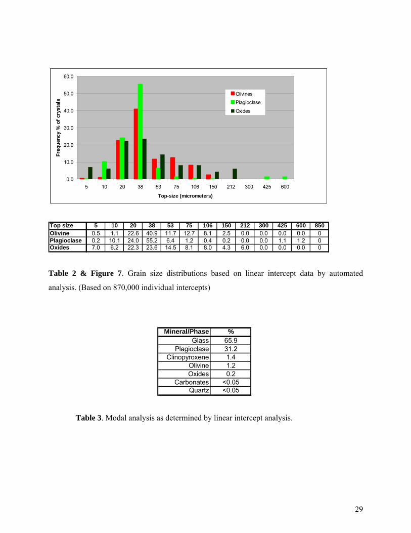
0.0
10.0
20.0
30.0
40.0
50.0
60.0
5 10 20 38 53 75 106 150 212 300 425 600
Top-size (micrometers)
Freq
uenc
y %
of c
ryst
als
OlivinesPlagioclase
Oxides
Top size 5 10 20 38 53 75 106 150 212 300 425 600 850Olivine 0.5 1.1 22.6 40.9 11.7 12.7 8.1 2.5 0.0 0.0 0.0 0.0 0Plagioclase 0.2 10.1 24.0 55.2 6.4 1.2 0.4 0.2 0.0 0.0 1.1 1.2 0Oxides 7.0 6.2 22.3 23.6 14.5 8.1 8.0 4.3 6.0 0.0 0.0 0.0 0
Table 2 & Figure 7. Grain size distributions based on linear intercept data by automated
analysis. (Based on 870,000 individual intercepts)
Mineral/Phase %Glass 65.9
Plagioclase 31.2Clinopyroxene 1.4
Olivine 1.2Oxides 0.2
Carbonates <0.05Quartz <0.05
Table 3. Modal analysis as determined by linear intercept analysis.
29

Conclusions
► A whole-rock and mineralogical analyses has been presented for a representative portion
of the submitted sample crushed to passing 850 micrometers.
► The material is composed of approximately 66% glass, and is considered a suitable
candidate as pozzolan. Most crystalline material within the glassy matrix should be inert
and not pose any problems to utilization as such
► Liberated crystalline materials include feldspar phenocrysts which will be inert,
carbonates which may assist in pozzolanic reactions, and oxides which may be amenable
to removal by magnetic or gravity separation if desirable.
► Confirmation of the presence of swelling clay is recommended to rule out the likelihood
of deleterious properties these may introduce.
► No sulphur is present which is advantageous.
30

31
APPENDIX C:
Certified Chemical Assay results
