preliminary site plan packet
DESCRIPTION
PSPPTRANSCRIPT

A-7
PRELIMINARY SITE PLAN
SUBMISSION REQUIREMENTS FOR COMPLETENESS REVIEW
Applications for Preliminary Site Plan approval submitted pursuant to Section 508 of the LDC shall
include:
Completed Land Development Application (Form B-1)
Completed Affidavit of Ownership / Agent Authorization (Form B-2)
Pre-application comments (if applicable)
Application fee payment receipt
Copy of previous development order approval (if applicable)
Affordable housing documents (if applicable)
EDC rapid response documentation (if applicable)
CRA rapid response documentation (if applicable)
Encouragement Zone (if applicable)
Historic Preservation Certificate of Appropriateness (if applicable) (copy of approval
or copy of application)
Completed Concurrency Deferral Form (Form B-11)
A completed Preliminary Site Plan Standards checklist (Form B-20) and a
Preliminary Site Plan.
Environmental Reports (see attachment #1 on Form B-1 Land Development
Application)
Applications for a combination Preliminary Site Plan/Preliminary Plat shall also include: o the Preliminary Plat Standards Checklist (Form B-22) and a o Preliminary Plat.
o Stormwater Drainage Calculations o SWFWMD Application Copy o Environmental Reports/Wetland Reports o Landscape Plan o Lighting Plan (if required)

MANATEE COUNTY GOVERNMENT BUILDING AND DEVELOPMENT SERVICES DEPARTMENT LAND DEVELOPMENT APPLICATION
FOR STAFF USE ONLY Date: File Number: _______________________________________________________
File Name: __________________________________________________________________________________________________
This application shall be used for all land development rezone or comprehensive plan amendment request. Please attach appropriate standards or supplementary information, as applicable.
NAME OF THE PROJECT:
TYPE OF APPROVAL DESIRED:
LIST CASE NUMBERS OF PREVIOUS APPROVALS:
A. Property Information
1. Legal Description:
2. D. P. Number(s):
3. Section: Township: Range:
4. Subdivision Name (if Platted):
5. Lot: 6. Block:
7. Address or Location of Property (See Address Coordinator, if physical address is needed):
8. Present Zoning Classification:
9. (If Rezone) Proposed Zoning Classification:
10. (If Comprehensive Plan Map Amendment) Proposed Future Land Use Category:
11. Future Land Use Category:
12. Flood Zone Category: Map/Panel Numbers:
13. Property Size (to the nearest tenth of acre or sq. ft.:
14. Existing Use(s) of Subject Property (i.e.: vacant, residence, commercial, etc.):
15. Surrounding Land Use(s) (i.e.: vacant, residence, commercial, etc.):
a. North: c. East:
b. South: d. West:
16. Description of Proposed Activity or Use (Attach separate Sheet if Necessary):

B. Names/Addresses
List all person(s) having ownership in subject property
1. Name of Property Owner:
Address:
Zip: Telephone: Fax:
Email Address:
2. Name of Property Owner:
Address:
Zip: Telephone: Fax:
Email Address:
3. Name of Agent:
Address:
Zip: Telephone: Fax:
Email Address:
4. Name of Engineer:
Address:
Zip: Telephone: Fax:
Email Address:
5. Name of Architect:
Address:
Zip: Telephone: Fax:
Email Address:
6. Name of Landscape Architect:
Address:
Zip: Telephone: Fax:
Email Address:
NOTE: UNLESS OTHERWISE NOTED, ALL WRITTEN CORRESPONDENCE WILL BE SENT TO THE AGENT. IF THERE IS NO AGENT, COMMENTS WILL BE SENT TO THE PROPERTY OWNER.

C. Signature I hereby certify that the information in this application is true and correct. I have read this application and understand that other review processes and fees may be required prior to applying for and receiving Building Permits and/or Final Development Approval. By executing this application, I acknowledge that I am familiar with the Rules of Procedure which apply to the boards or commissions which will act on my application and that I have read and understand such Rules of Procedures. (Signature of Property Owner or Agent)
Additional Information CONTACT: Building and Development Services Department
Reviewer on Call 1112 Manatee Avenue West, Fourth Floor 34205 P. O. Box 1000, Bradenton, FL 34206 Telephone: (941) 748-4501, Extension 3070 Fax Number: (941) 708-6152
http://www.mymanatee.org Rev. 11/6/12
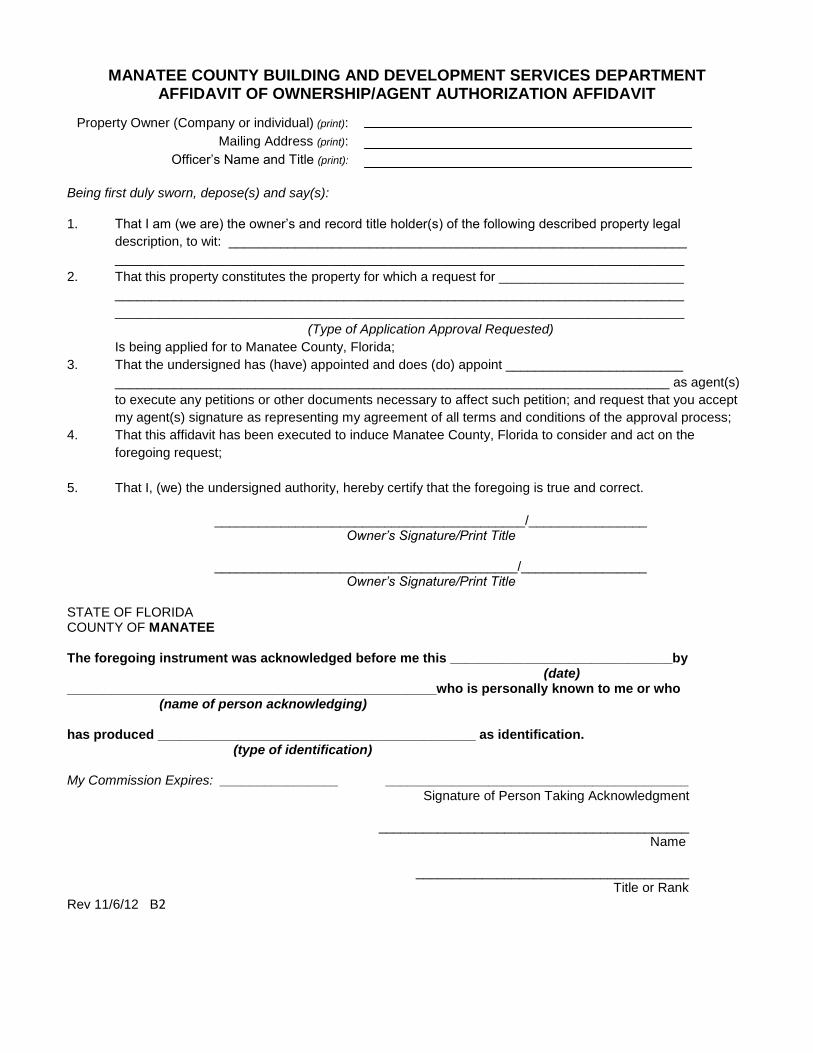
MANATEE COUNTY BUILDING AND DEVELOPMENT SERVICES DEPARTMENT AFFIDAVIT OF OWNERSHIP/AGENT AUTHORIZATION AFFIDAVIT
Being first duly sworn, depose(s) and say(s): 1. That I am (we are) the owner’s and record title holder(s) of the following described property legal
description, to wit: ______________________________________________________________
_____________________________________________________________________________
2. That this property constitutes the property for which a request for _________________________
_____________________________________________________________________________
_____________________________________________________________________________
(Type of Application Approval Requested)
Is being applied for to Manatee County, Florida;
3. That the undersigned has (have) appointed and does (do) appoint ________________________
___________________________________________________________________________ as agent(s)
to execute any petitions or other documents necessary to affect such petition; and request that you accept
my agent(s) signature as representing my agreement of all terms and conditions of the approval process;
4. That this affidavit has been executed to induce Manatee County, Florida to consider and act on the
foregoing request;
5. That I, (we) the undersigned authority, hereby certify that the foregoing is true and correct.
__________________________________________/________________
Owner’s Signature/Print Title
_________________________________________/_________________ Owner’s Signature/Print Title
STATE OF FLORIDA COUNTY OF MANATEE The foregoing instrument was acknowledged before me this ______________________________by (date) __________________________________________________who is personally known to me or who (name of person acknowledging) has produced ___________________________________________ as identification. (type of identification) My Commission Expires: ________________
_________________________________________ Signature of Person Taking Acknowledgment
__________________________________________
Name
_____________________________________ Title or Rank
Rev 11/6/12 B2
Property Owner (Company or individual) (print): Mailing Address (print):
Officer’s Name and Title (print):
MANATEE COUNTY GOVERNMENT
BUILDING AND DEVELOPMENT SERVICES DEPARTMENT
“DEFERRAL and ACKNOWLEDGMENT” OF EVENUTAL REQUIREMENT FOR “CONCURRENCY’ CERTIFICATION
NOTE: When an application for a development order defers “Concurrency” certification to a later stage of approval, the property
owner(s) or authorized representative(s) must acknowledge the eventual requirement for certification. A development order that does not
have a “Concurrency” Certificate of Level of Service Compliance shall not grant any rights or entitlements to certification; shall not
exempt the proposed development from the eventual requirements for certification; and shall not grant any rights to commence
development without certification.
Project File # Date
Project Name
Type of Approval Requested
Sec Twp Rge TAZ
D.P. No.(s)
Land Area (acres)
PRINT NAME OF ALL PROPERTY OWNERS:
Being first duly sworn, depose(s) and say(s):
1. That (I am/we are) the owner(s) and record title holder(s) or authorized representative(s) of the following
described property: (print legal description)
2. That this property constitutes the property for which a request for approval is sought precedent to the use or
development of land and is sought through the Building and Development Services Department, an
administrative agency of the Board of County Commissioners of Manatee County, Florida.
3. That (I/we) hereby recognize and acknowledge that any approval of the above-cited request shall not exempt
me/us, or the successors and/or assigns of the property, when seeking further development approval(s) from
Manatee County Government for the above-cited property, from the requirement for a Certificate of Level of
Service which shall ensure the adequacy of public facilities to serve land development according to the adopted
level-of-service standards.
4. That (I/we) hereby recognize and acknowledge that any approval of the above-cited request shall not grant
me/us, or the successors and/or assigns of the property, any rights or entitlements to a Certificate of Level of
Service Compliance, public facility capacities or approval to commence development.
5. That (I/we) hereby recognize and acknowledge that any approval of the above-cited request shall not assure
me/us, or the successors and/or assigns of the property, of future adequate capacities in public facilities, and
that (I/we) proceed aware of the risk of future inadequate capacities.
AFFIX SIGNATURES OF ALL PROPERTY OWNER(S)/AGENT(S):
OWNER/AGENT OWNER/AGENT
OWNER/AGENT OWNER/AGENT
Sworn to and subscribed before me this day of , 20 .
SEAL
Notary Public
B11 revised 11/6/12

PRELIMINARY SITE PLAN STANDARDS
The following minimum information is required by the Manatee County Land Development
Code. Applications will NOT be processed unless all required information is submitted. Any
item believed “not applicable” must be explained in writing and noted on the plan.
Note: Applicant must check () and give page number on which information is provided.
1. Basic Information Page #/Applicant/Staff
a. Sheet size, max. 24” x 36”, numbered
(i.e., sheet ___ of ___). Multiple
sheets (match lines clearly showing
where sheets join).
_____ ( ) ( )
b. The words "PRELIMINARY SITE PLAN" clearly
stated.
_____ ( ) ( )
c. Date, north arrow, scale (1" = 60' or larger) and
legend.
_____ ( ) ( )
d. All lettering shall be neat and legible, and a
minimum of 3/32" in height.
_____ ( ) ( )
e. Vicinity map (scale of not less than 1" = 1 mile)
which clearly shows the site in relationship to its
surrounding.
_____ ( ) ( )
f. All dimensions shall be in feet and decimals of a
foot.
_____ ( ) ( )
g. Standard signature sign-off block. _____ ( ) ( )
NOTE: Survey is required with all Planned Development
Rezones.
2. Existing Site Conditions
a. Total project acreage. _____ ( ) ( )
b. Existing zoning and land uses onsite and on
properties within two hundred (200) feet of the
property boundaries.
_____ ( ) ( )
c. The approximate location and size of existing
easements, existing and platted streets, drainage
ways, utilities, buildings and historic sites on site.
_____ ( ) ( )

d. Location of existing and platted streets,
drainageways, and utilities on contiguous
properties a minimum of 100’ beyond perimeter.
_____ ( ) ( )
e. General topographic contours (five feet maximum
interval) on site.
_____ ( ) ( )
f. Delineation of the flood zones and the Flood
Protection Elevation data onsite, if applicable.
_____ ( ) ( )
g. Where the project exceeds one hundred (100)
acres in area, the latest available aerial photograph
made at a scale of at least one inch equals four
hundred feet (1"=400') showing all property within
one thousand (1000) feet of the project boundaries.
_____ ( ) ( )
h. Preliminary wetlands delineation, as required in
Section 719 (See attachment #1).
_____ ( ) ( )
i. Location of existing tree groupings pursuant to
Section 714
_____ ( ) ( )
3. Development Description
a. The approximate locations, intensity, and acreage
of general land uses including dwelling unit types
and general types of non-residential uses, open
spaces, recreational facilities, and other proposed
uses.
_____ ( ) ( )
b. Proposed densities for each dwelling unit type and
approximate total number of dwelling units by
type.
_____ ( ) ( )
c. Floor area ratios for all non-residential land uses
and approximate total square footage of gross floor
area for all non-residential buildings by general
type, e.g. offices, neighborhood commercial,
industrial, etc.
_____ ( ) ( )
d. Amount of additional density or floor area applied
for under any bonus provisions, and the
calculations supporting the specific features giving
rise to such bonus application.
_____ ( ) ( )
e. Proposed development construction schedule
indicating the approximate starting and completion
dates for the project and any phases thereof,
together with appropriate identification and
descriptions of such phases.
_____ ( ) ( )

4. Proposed Site Design
a. Approximate dimensions and location of:
1. Proposed lot lines and land uses. _____ ( ) ( )
2. Proposed structures. _____ ( ) ( )
3. Proposed infrastructure. _____ ( ) ( )
4. Proposed and required easements. _____ ( ) ( )
5. Proposed open space areas. _____ ( ) ( )
6. Proposed parking and loading areas. _____ ( ) ( )
7. Proposed Landscape Plan - A landscape
plan showing Vehicle Use Area
landscaping, including approximate
locations of landscape areas and
preliminary plant material calculations.
Screening buffers, including approximate
locations of the buffer areas and
preliminary plant material calculations.
_____ ( ) ( )
8. Proposed Vehicle Use Area Landscaping,
including approximate locations of
landscape areas and preliminary plant
material calculations. Screening buffers,
including approximate locations of the
buffer areas and preliminary plant material
calculations.
_____ ( ) ( )
9. Proposed vehicular circulation facilities. _____ ( ) ( )
10. General sign and outdoor lighting plans,
location or design principles.
_____ ( ) ( )
b. Approximate dimensions of all building heights
and required yards.
_____ ( ) ( )
c. General sign and outdoor lighting plans, location
or design principles.
_____ ( ) ( )
5. Required Improvements
A description of intended actions necessary to satisfy the
requirements of Section 722, Installation of Required

Improvements. Such description shall be provided in
graphic or narrative form, as necessary.
Water Service _____ ( ) ( )
Sewer Service _____ ( ) ( )
Solid Waste _____ ( ) ( )
Fire Protection _____ ( ) ( )
Effluent reuse for irrigation _____ ( ) ( )
Sidewalks and distance to existing sidewalks _____ ( ) ( )
Access, including cross section _____ ( ) ( )
Drainage, including cross section _____ ( ) ( )
6. Supplemental Information
a. General description of proposed legal measures to
provide for any easements, dedications and
reservations.
_____ ( ) ( )
If the site is located within the 100 year floodplain, the information required for a Floodplain Management Permit is required. (Due at building permit stage).
MANATEE COUNTY BUILDING AND DEVELOPMENT SERVICES DEPARTMENT LAND DEVELOPMENT APPLICATION
PRELIMINARY SITE PLAN STANDARDS AND PRELIMINARY PLAT STANDARDS
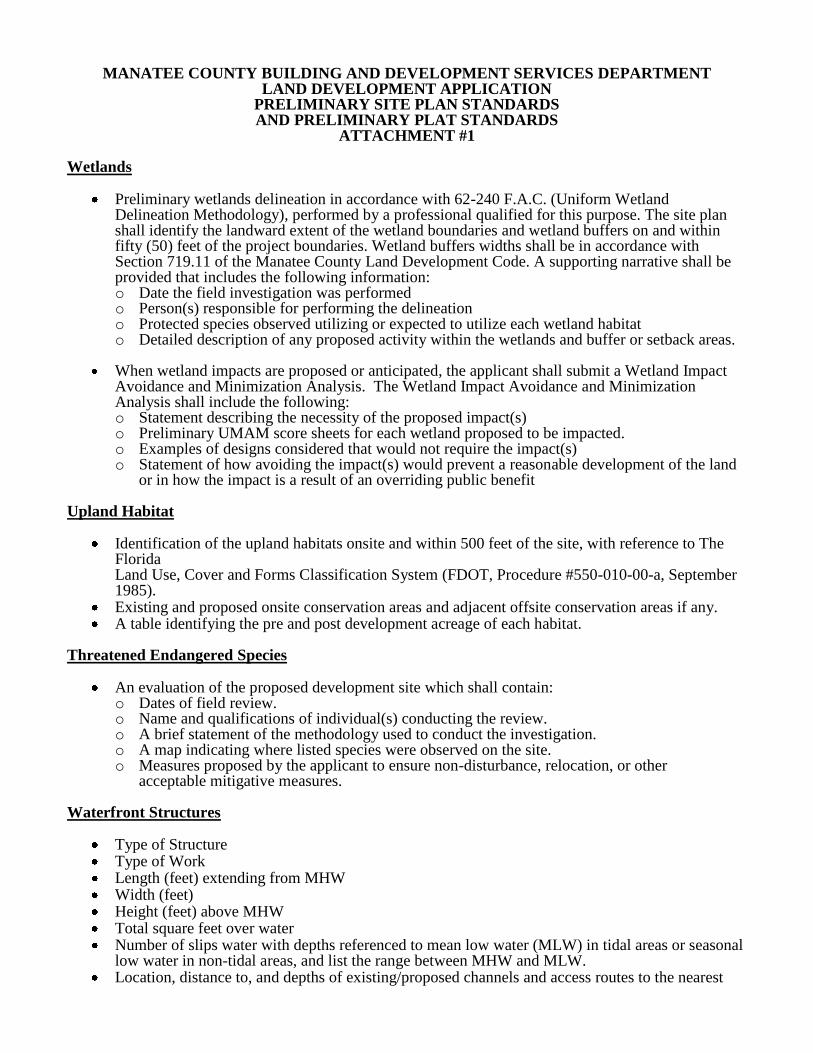
ATTACHMENT #1 Wetlands
Preliminary wetlands delineation in accordance with 62-240 F.A.C. (Uniform Wetland Delineation Methodology), performed by a professional qualified for this purpose. The site plan shall identify the landward extent of the wetland boundaries and wetland buffers on and within fifty (50) feet of the project boundaries. Wetland buffers widths shall be in accordance with Section 719.11 of the Manatee County Land Development Code. A supporting narrative shall be provided that includes the following information: o Date the field investigation was performed o Person(s) responsible for performing the delineation o Protected species observed utilizing or expected to utilize each wetland habitat o Detailed description of any proposed activity within the wetlands and buffer or setback areas.
When wetland impacts are proposed or anticipated, the applicant shall submit a Wetland Impact
Avoidance and Minimization Analysis. The Wetland Impact Avoidance and Minimization Analysis shall include the following: o Statement describing the necessity of the proposed impact(s) o Preliminary UMAM score sheets for each wetland proposed to be impacted. o Examples of designs considered that would not require the impact(s) o Statement of how avoiding the impact(s) would prevent a reasonable development of the land
or in how the impact is a result of an overriding public benefit
Upland Habitat
Identification of the upland habitats onsite and within 500 feet of the site, with reference to The Florida Land Use, Cover and Forms Classification System (FDOT, Procedure #550-010-00-a, September 1985).
Existing and proposed onsite conservation areas and adjacent offsite conservation areas if any. A table identifying the pre and post development acreage of each habitat.
Threatened Endangered Species
An evaluation of the proposed development site which shall contain: o Dates of field review. o Name and qualifications of individual(s) conducting the review. o A brief statement of the methodology used to conduct the investigation. o A map indicating where listed species were observed on the site. o Measures proposed by the applicant to ensure non-disturbance, relocation, or other
acceptable mitigative measures. Waterfront Structures
Type of Structure Type of Work Length (feet) extending from MHW Width (feet) Height (feet) above MHW Total square feet over water Number of slips water with depths referenced to mean low water (MLW) in tidal areas or seasonal
low water in non-tidal areas, and list the range between MHW and MLW. Location, distance to, and depths of existing/proposed channels and access routes to the nearest

navigational channel Number and location of any proposed live-aboard Slips Number and location of any proposed or existing fueling facilities Number and location sewage pump-out facilities? Location and depth of any proposed dredging