preparatory study for north east road … · 2017-07-07 · widening and improvement of nh-40 ......
TRANSCRIPT
MINISTRY OF ROAD TRANSPORT AND HIGHWAYS NATIONAL HIGHWAY AND INFRASTRUCTURE DEVELOPMENT CORPORATION
PREPARATORY STUDY FOR NORTH EAST ROAD NETWORK CONNECTIVITY IMPROVEMENT
PROJECT (PHASE-2)
WIDENING AND IMPROVEMENT OF NH-40 (SHILLONG – DAWKI)
RESETTLEMENT ACTION PLAN
June 2017
PREPARED BY: ENVIRO INFRA SOLUTIONS PVT. LTD
301, 302, & 305, SHREE RAM BUSINESS CENTRE, PLOT NO. INS-12, SECTOR-9, VASUNDHARA, GHAZIABAD – 201012
Table of Contents
ABBRIVIATIONS
EXECUTIVE SUMMARY .......................................................................................................................... (i)
INTRODUCTION ......................................................................................................................1 Chapter 1
Background .............................................................................................................................................1 1.1
Project Location ......................................................................................................................................1 1.2
Requirement and Objective of RAP Report ............................................................................................2 1.3
Issues Related to Indigenous People .......................................................................................................2 1.4
Description of the Project ...........................................................................................................3 Chapter 2
The Project Background. .........................................................................................................................3 2.1
Scope of Work .........................................................................................................................................3 2.2
Minimization of Resettlement: ................................................................................................................3 2.3
Project impacts and benefits ....................................................................................................................4 2.4
Policy and Legal Framework ......................................................................................................5 Chapter 3
Summary of Acts and Policies ................................................................................................................5 3.1
Key policies and Legislations..................................................................................................................6 3.2
3.3 Key Gap between LARR 2013 and JICA guidelines ............................................................................10
Applicability of LARR 2013 in the context of Meghalaya. ..................................................................18 3.4
SOCIO ECONOMIC PROFILE ...............................................................................................19 Chapter 4
Introduction ...........................................................................................................................................19 4.1
Socio Economic Profile of Meghalaya-East Khasi Hills and Jaintia Hills Districts .............................23 4.2
Social Profile of the Project Affected Households ................................................................................27 4.3
SOCIAL IMPACT OF THE PROJECT ...................................................................................40 Chapter 5
Introduction ...........................................................................................................................................40 5.1
Impact of Affected Households and Structures .....................................................................................40 5.2
Impact on Land ......................................................................................................................................41 5.3
Impact on trees and crops. .....................................................................................................................42 5.4
Social Impacts .......................................................................................................................................44 5.5
STAKEHOLDER CONSULTATION .....................................................................................49 Chapter 6
Overview ...............................................................................................................................................49 6.1
Method of Stakeholders consultation ....................................................................................................49 6.2
1st Round consultation with Communities: ...........................................................................................49 6.3
2nd
Round Consultation with Communities ...........................................................................................54 6.4
Supplemental Consultation Meetings ....................................................................................................55 6.5
Information Disclosure ..........................................................................................................................56 6.6
RESETTLEMENT POLICY ....................................................................................................58 Chapter 7
Objective of Resettlement Policy Framework .......................................................................................58 7.1
Entitlement Matrix: ...............................................................................................................................59 7.2
Methods of Assessing Replacement Cost .............................................................................................64 7.3
Grievance Redress Mechanism .............................................................................................................64 7.4
INSTITUTIONAL ARRANGEMENTS ..................................................................................67 Chapter 8
Institutional arrangements .....................................................................................................................67 8.1
Monitoring and Evaluation. ...................................................................................................................68 8.2
Non-Governmental Organization for Implementation of RP. ...............................................................69 8.3
GENDER ..................................................................................................................................71 Chapter 9
Introduction ...........................................................................................................................................71 9.1
Project potential impact: ........................................................................................................................71 9.2
Improvement in Project Preparation and Implementation .....................................................................72 9.3
Equity in Construction Activities. .........................................................................................................72 9.4
Measures for Controlling STD and HIV/AIDS: ....................................................................................73 9.5
INDIGENOUS PEOPLE ..........................................................................................................74 Chapter 10
Introduction .........................................................................................................................................74 10.1
Traditional Livelihoods in Meghalaya State and Project Districts ......................................................78 10.2
Public Consultation .............................................................................................................................83 10.3
Market, Distribution and Processing of Agricultural / Non – Agricultural Produces .........................87 10.4
Livelihood Frameworks ......................................................................................................................92 10.5
REHABILITATION PLAN .....................................................................................................98 Chapter 11
Rehabilitation Plan ..............................................................................................................................98 11.1
RESETTLEMENT BUDGET ................................................................................................102 Chapter 12
R&R Cost. .........................................................................................................................................102 12.1
Replacement Cost of Structures ........................................................................................................102 12.2
Market Value of Trees .......................................................................................................................103 12.3
RP Implementation Cost. ..................................................................................................................103 12.4
Replacement cost of CPR ..................................................................................................................103 12.5
R&R Budget ......................................................................................................................................104 12.6
RESETTLEMENT SCHEDULE ...........................................................................................106 Chapter 13
Introduction .......................................................................................................................................106 13.1
Schedule for project implementation ................................................................................................106 13.2
Schedule for Resettlement Action Plan .............................................................................................106 13.3
R&R Implementation Schedule .........................................................................................................106 13.4
Appendices
Appendix-1: Household Interview Survey -Form of Questionnaire ............................................................... A1
Appendix-2: Signature of the Attendees on Stakeholders Consultation ...................................................... A16
Appendix-3: Resettlement and Rehabilitation Monitoring Form ................................................................ A28
Appendix-4: Terms of Reference of the RAP Supporting Agency.............................................................. A30
Appendix-5: Terms of Reference of the External Monitoring Agency (EMA) ........................................... A34
List of Tables
Table 3.1-1: Acts / Policies / Notifications & their relevance to the project ............................................5
Table 3.3-1: Key gap between JICA and Indian Regulations .................................................................11
Table 4.1-1: Demographic profile of Meghalaya ...................................................................................20
Table 4.1-2: Demographic profile of East Khasi Hills district ................................................................21
Table 4.1-3: Demographic profile of West Jaintia Hills district .............................................................23
Table 4.2-1: District wise population and percentage of SC and ST ......................................................23
Table 4.2-2: Poverty and Human Development scenario ........................................................................24
Table 4.2-3: District wise Per Capita Income .........................................................................................24
Table 4.2-4: District wise HDI ................................................................................................................24
Table 4.2-5: District wise Scheduled Tribes ...........................................................................................25
Table 4.3-1: Summary of the Survey ......................................................................................................28
Table 4.3-2: Details of PAHs ..................................................................................................................31
Table 4.3-3: Social category ....................................................................................................................34
Table 4.3-4: Ethnicity background ..........................................................................................................34
Table 4.3-5: Religion ...............................................................................................................................35
Table 4.3-6: Education Level ..................................................................................................................35
Table 4.3-7: Occupation ..........................................................................................................................36
Table 4.3-8: Total monthly household income of H/H from all sources (INR/month) ..........................36
Table 4.3-9: Number of employed members in a PAH ...........................................................................37
Table 4.3-10: Public amenities ................................................................................................................37
Table 4.3-11: Ownership of Structure .....................................................................................................38
Table 4.3-12: Land System .....................................................................................................................38
Table 4.3-13: Vulnerability .....................................................................................................................39
Table 4.3-14: Socio-economic status of villages in BP2 and BP5 ..........................................................39
Table 5.2-1: Impact of Affected Households and Structures ..................................................................40
Table 5.2-2: Impact of Affected Households and Structures ..................................................................40
Table 5.3-1: Affected Land .....................................................................................................................41
Table 5.3-2: Land System .......................................................................................................................42
Table 5.4-1: Affected Trees .....................................................................................................................43
Table 5.4-2: Affected Crops ...................................................................................................................43
Table 5.5-1 Sacred Groves in East Khasi Hills and Jaintia Hills ............................................................48
Table 5.5-2 List of Monoliths..................................................................................................................49
Table 6.3-1: Details of 1st-round meetings .............................................................................................50
Table 6.3-2: Participation details of 1st round consultations ..................................................................53
Table 6.3-3: Community Meetings and Focus Group Discussions (FGD) .............................................53
Table 6.4-1: Details of 2nd
Round Meetings ............................................................................................54
Table 6.4-2: Participation details of 2nd
Round Meetings .......................................................................55
Table 6.5-1: Details of All Meetings .......................................................................................................55
Table 6.5-2: Participation Details of Supplemental Consultation Meetings ...........................................55
Table 7.2-1: Entitlement Matrix ..............................................................................................................60
Table 10.1-1: Tools and methods of data collection ...............................................................................77
Table 10.2-1: Land uses in the Area of Khasi Hills Autonomous District Council ................................79
Table 10.3-1: Village wise consultation profile ......................................................................................83
Table 10.3-2: Focus Group Discussion Findings ....................................................................................83
Table 12.2-1: Replacement Cost of Structures ......................................................................................102
Table 12.3-1: Market Value of Trees* ..................................................................................................103
Table 12.6-1: R&R Budget ...................................................................................................................105
Table 13.4-1: Resettlement Schedule ....................................................................................................109
List of Figures
Figure 4.1-1: Map of Meghalaya State ....................................................................................................19
Figure 4.1-2: Map of East Khashi Hills District......................................................................................21
Figure 4.1-3: Map of Jaintia Hills District (currently East/ West Jaintia Hills) ......................................22
Figure 4.2-1: Khasi Traditional Institutions Figure 4.2-2: Jaintia Traditional Institutions ..............26
Figure 4.2-3: Garo Traditional Institutions .............................................................................................27
Figure 4.3-1: Affected Villages ...............................................................................................................33
Figure 5.5-1: Location of Sacred Groves along NH40 ............................................................................47
Figure 6.6-1: 1st Stakeholders/community Meetings ...............................................................................56
Figure 6.6-2: 2nd Stakeholders/community Meetings ............................................................................57
Figure 7.4-1: Grievance Redress Mechanism .........................................................................................66
Figure 8.1-1: Institutional arrangements .................................................................................................67
Figure 10.2-1: Map Showing Land Uses in the Area of Khasi Hills Autonomous District Council ......79
Figure 10.2-2: Area where shifting cultivation is practiced along NH40 ...............................................80
Figure 10.2-3: Cases of Area where Quarry is practiced along NH40 ....................................................82
Figure 10.3-1: Consultation Meetings/FGD ...........................................................................................86
ABBREVIATIONS
BPL : Below Poverty Line
BSR : Basic Schedule of Rates
CA : Competent Authority
DDP : Desert Development Program
DPR : Detailed Project Report
FPIC : Government of India
GRM : Grievance Redress Mechanism
GRC : Grievance Redress Committee
IPP : Indigenous Peoples Plan
IRC : Indian Road Congress
JICA : Japan International Cooperation Agency
LARR : Land Acquisition, Rehabilitation, and Resettlement Act
LSC : Land Settlement Certificates
MAW : Minimum Agricultural Wage
MFP : Minor Forest Produce
NH : National Highway
NHIDCL: National Highway & Infrastructure Development Corporation Limited
NRRP : National Rehabilitation and Resettlement Policy
NEEDS: North East Educational and Development Society
OBC : Other Backward Class
PAF : Project Affected Family
PAH : Project Affected Households
PAP : Project Affected Person
PIU : Project Implementation Unit
PPP : Public Private Partnership
PWD : Public Works Department
RAP : Resettlement Action Plan
R&R : Resettlement and Rehabilitation
ROW : Right of Way
SC : Scheduled Caste
SIA : Social Impact assessment
ST : Scheduled Tribe
i
EXECUTIVE SUMMARY
The North East Connectivity Improvement Project is an initiative of the Government of India to better the
quality and connection of roads in the North Eastern Region of the country, to strengthen the linkages of this
region and to improve the economic situation of the region as a whole. Amongst many highways, the NH 40
connecting Shillong in East Khasi Hills District to Dawki in the West Jaintia Hills District was selected to
benefit from this development project. GOI requested Government of Japan to provide assistance in carrying
out the improvement of Shillong-Dawki section and the study has been implemented upon the request.
This document was prepared under the responsibility of NHIDCL supported by JICA during Preparatory
Study for North East Road Network Connectivity Improvement Project (Phase 2) in order to report on the
socio-economic status of the entire affected areas of the project. It will reflect the living conditions, health
status, education and livelihood of the Project Affected Persons; the civic amenities available, the various
sources income of the PAPs, the gender dimensions in the households/community, will be discussed in brief
in this report based on the household survey conducted.
The socio-economic survey was conducted by a local NGO called North East Educational Development
Society (NEEDS). Before the survey started, a number of meetings with stakeholders and communities were
conducted for awareness. There are 418 households (or 402 HHs in case that BP5 is excluded from the
Project) whose house, shop and/or land is affected by the project. The land acquisition process is thus
discussed in this report stating the country existing laws, the guidelines of JICA and the need to consider the
State of Meghalaya’s various traditional/ customary laws and practices, involving the Autonomous District
Councils and the traditional village leaders in the implementation plan. Meghalaya has its own peculiar land
tenure system, for instance, a lot of lands especially in rural areas are collectively owned by clans and any
project requiring land acquisition in such areas will need consent from the clan leaders residing in the area
and not just the affected clan members. This is an arduous process especially if the clan has internal conflicts
and disagreements. However on the plus side this system has helped preserve the lands of the clans, where
even those members who may be landless are offered a small plot to build a house and farm.
Right to Fair Compensation and Transparency in Land Acquisition, Rehabilitation and Resettlement Act,
2013 (LARR 2013) has been applied and referred to in this report. The tentative budget is made based on the
rules of LARR 2013. The authority implementing the project, the State Government, in the process of land
acquisition can refer to this Act and also consider the traditional and customary laws of the State and the
previous land acquisition processes followed.
In Accordance with LARR 2013, Social Impact Assessment (SIA) shall be conducted by an independent
autonomous body as per section 4. SIA shall be reviewed by an Independent Expert Committee. Preliminary
Notification for land acquisition will be issued by State Revenue Department as per section 11 of LARR 2013.
Hearing of objection will be made as per section 15. As per section 16, administrator appointed by the State
Government shall prepare resettlement plan. Rehabilitation and Resettlement Plan and compensation policy
proposed in this report are intended to be incorporated into implementation procedure by Indian side
including Social Impact Assessment, Social Impact Management Plan, and Rehabilitation and Resettlement
Scheme.
ii
The Grievance Redress Mechanism will be established. The implementation agency will provide all necessary
help to PAP in presenting his/her case using the mechanism. The decision of the Grievance Redress
Committee will not be binding on the PAP, and he/she is allowed to proceed to resolve the case in the high
court.
The internal monitoring will be carried out by the PIU, PWD with assistance from RAP Implementation
Agency. An External agency will be hired to undertake biannual monitoring and mid and end term evaluations.
The Project is located entirely in East Khasi Hills District and West Jaintia Hills District of Meghalaya State,
inhabited by Khasi and Jaintia with a few Garo, deemed to be Scheduled Tribes in Constitution of India.
Khasi and Garo will be considered as Indigenous Peoples (IPs) in the contexts of India as a whole, since they
are registered as STs. However, the Project will be implemented only in the areas where Kashi and Garo are
dominant, and their political and decision-making structures are based on their social and cultural/traditional
contexts. Thus, it is deemed that preparation of IP’s Paper under OP 4.10 is not necessary for the Project. On
the other hand, requirements for considerations to IPs were satisfied for preparation of RAP, including FPIC,
and IPP elements are incorporated in the RAP.
The NGO - Tynrai Foundation conducted the first round of extensive consultation at community / village
level in the project area. Community level consultation (Focus Group Discussion and Interviews) were held
with targeted beneficiaries and the primary stakeholders of the project in 6 villages across the 2 districts of
project area. These consultations included women, youth, BPL House Holds, Self Help Group members, and
the farmers. The consultation meetings also involved tribal and other customary village leaders, members of
village councils. The consultations were free, in local language, and conducted with prior information
disseminated through consultation team. The consultation indicated strong demand and broad community
support for livelihood interventions.
During Focus Group Discussion and social assessment, the team has identified key social issues which have
been elaborated in respective chapter. Based on identified key issues, a strategy was developed to implement
livelihood program in project affected area. Along with livelihood strategy, gender strategy also was be
framed.
1
INTRODUCTION Chapter 1
Background 1.1
The trend of development in the Indian Economy is soaring, with an expected rate of 8 to 9 % every year.
With brisk development comes the realization that plans for sustenance of the same must be instituted.
Service and industry sectors are expected, therefore, to grow swiftly, and infrastructure in terms of roads
and other forms of connectivity are and will continue to take substantial leaps. This is especially true to
parts of the country that are remote from the mainland India and where road connectivity forms the key
issue to any form of development. The North eastern region of the country is highly dependent on roads
for transport of goods and people. Although roads play a significant role in the economic development of
the region, yet the conditions of the roads are not good.
The State of Meghalaya, which has great potential for contributing to the country’s current economic
growth, being that the State is very rich in mineral resources. The State is however connected to the rest
of the country only by land; the small airports available in Shillong and Tura are insignificant in their
contributions towards the much needed connectivity of the State. Hence roads have and will continue to
be the major link of this State with the rest of the country. However, the nature and weather of the State
makes the effort very challenging- Meghalaya is famous for heavy rainfall mixed with the perilous terrain.
Recognizing the region’s typical characteristics and challenges in achieving economic growth, the
Government of India started the “Special Accelerated Road Development Program for North East”
wherein national highways that connect North East with major cities of the country are being improved.
The Government of Japan has been requested to provide Loan assistance in this road improvement plan.
The Shillong-Dawki road, which is a section of the NH-40 is one of the highways selected. It is located in
the East Khasi Hills and West Jaintia Hills districts of Meghalaya.
Project Location 1.2
The section of NH 40 starts from Shillong up to Dawki, with a total stretch of 84 km on existing road
basis. The first entry point of the study road is at the periphery of the main city and goes on to pass
through various rural villages, inclusive of forests and agricultural fields; the most distinctive however are
the deep gorges and precipices that are seen along a major section of the road. At present Shillong–Dawki
section of NH-40 is in good condition with footpath on both side of the road and drainage system in
places up to the area of Eastern Air Force Headquarters. The length is approximately 8 km from the
starting point while this section is climbing the mountain slope to 1,800 m thereafter the width of road,
without road furniture, is generally two lanes up to the 61 km post climbing down East Khasi Hills. The
last 6-7 km section of NH-40 nearer Dawki is particularly narrow without appropriate road furniture,
causing traffic congestion going out to Bangladesh and coming into India.
2
Requirement and Objective of RAP Report 1.3
The widening of roads and the construction of by passes in the entire road will necessitate land
acquisition. LARR 2013 requires that any development project that results in land acquisition and
displacement of people will need to prepare a Resettlement Action plan The Government is also
responsible for rehabilitation of the displaced people once the Right of Way (ROW) is ascertained.
This RAP report is an introducing document for R&R prepared under the responsibility of NHIDCL
supported by JICA during Preparatory Study for North East Road Network Connectivity Improvement
Project (Phase 2) It is based on preliminary designs and will assist the discussion between Government
and NHIDCL over the Land acquisition and involuntary resettlement expected in this project; it will help
ensure that the process of land acquisition, R&R is implemented in an efficient method keeping the
guidelines for Environmental and Social considerations of JICA in focus.
Issues Related to Indigenous People 1.4
Meghalaya is predominantly inhabited by Scheduled Tribes. The majority of its population are from the
major tribes of the Khasi, the Jaintia and the Garo. Besides the Khasi, Jaintia and Garo, the State has a
host of other tribes that reside in the State and have ownership of land and legal residency. Such groups
are: the Mizo, Hmar, (Mikir, Rabha,), Paitei, Meitei etc. All these groups are groups from neighboring
states who migrated to Meghalaya and have settled here for countless years. These groups continue to
follow their own customs and traditions.
The Project is also located entirely in the area inhabited by Khasi and Jaintia with a few Garo. Khasi and
Garo will be considered as Indigenous Peoples (IPs) in the contexts of India as a whole, since they are
registered as STs. However, the Project will be implemented only in the areas where Kashi and Garo are
dominant, and their political and decision-making structures are based on their social and
cultural/traditional contexts. Thus, it is deemed that preparation of IP’s Paper under OP 4.10 is not
necessary for the Project. On the other hand, requirements for considerations to IPs were satisfied for
preparation of RAP, including FPIC, and IPP elements are incorporated in the RAP.
Besides the Scheduled Tribes, Meghalaya is also home, to a number of non-tribal groups such as the
Assamese, Bengalis, and the Nepalese. These groups have no traditional connection with the major tribal
groups of Meghalaya but in the case of the Assamese and Bengalis, there is a political and social
connection, in that, Meghalaya was once a part of Assam; Hence, Meghalaya has a mixed population of a
sizeable non-tribal groups, gives it a character of a small India. In recent times, the State is witnessing
increasing migration from other States and neighboring countries such as Bangladesh. Being a transit
State with porous borders, Meghalaya may see an increase in migration of non-tribal groups into the State.
3
Description of the Project Chapter 2
The Project Background. 2.1
The North eastern region of India is always behind in terms of progressive development. Some of the
region’s issues are so deep seated, that the ramifications continue to produce negative effects on the
development efforts of the region. Investments and ventures from outside are sparse due to the law and
order situation in the region, and the existing resources of the region are under- utilized because of the
poor linkage that the region has with the rest of the country.
The most efficient mode of transport in the North East of India is roads. The trade and commerce in the
region hence, is wholly dependent on roads; yet the condition and size of the roads here are dismal, with
flawed maintenance. The Government of India has acknowledged this challenge and has requested the
Government of Japan to provide loan assistance to address this challenge thoroughly. The Shillong-
Dawki (NH -40) road in Meghalaya amongst others was selected to benefit from this project.
The Shillong-Dawki road is a total length of 84km on existing road. The Vertical interval of the study
road is very high, starting from approximately 1,525m, climbing up to 1800m and down.to approximately
50m at the ending point. There are a few narrow sections located between deep valley and overhanging
rocky slope. The old steel suspension bridge (L=135m) near the end of the study road is proving to be a
bottle neck of the study road due to 1 lane bridge width.
Scope of Work 2.2
The proposed project work includes widening of existing single lane road into two-lane widening with
asphalt paving on NH 40 from Shillong to Dawki in Meghalaya State. The widening of the road will be
limited to the existing ROW, as much as possible. Within the major settlements with congested market
places the improvement work will be extended with the construction of a Bypass.
The Project road is a length of 84km on existing road and 71.5 km after realignment based on the DPR.
On completion, the road will improve the road connectivity within the State and bring economic
development to the State. The responsible agency is the Ministry of Road Transport and Highways and
the National Highway and Infrastructure Development Corporation Limited.
Minimization of Resettlement: 2.3
Sufficient consideration is in place for preparation to minimize any adverse impacts on the community in
the project area while also considering the limitation of technical conditions and constraints.
The following key measures are taken to minimize resettlement in this project road.
Accommodating road widening within available ROW.
Saving cultural properties and community structures by adopting suitable measures.
Restriction of improvement work within the existing formation width in major settlements.
Alternate with a bypass in areas where huge settlements and markets are existing.
4
Project impacts and benefits 2.4
The project intends to improve and widen the Shillong –Dawki section of NH 40 and will have a direct
impact on the social and economic condition of the people living in the project and the entire region; the
State as a whole will benefit from the enhance connectivity. While the impact is more positive, negative
impacts of a social character is possible. The key benefits however would be:
A robust and profitable trade and commerce will be established with support for local
economic development.
Tourism will be scaled up in terms of tourists satisfaction and hence revenue increased.
Reduction of traffic congestion.
Consumer savings and affordability (savings to lower-income households)
Safety and ease of mobility of pedestrians.
Energy conservation
Air, noise, and water pollution reductions.
Habitat protection
5
Policy and Legal Framework Chapter 3
Summary of Acts and Policies 3.1
Development projects, such as those related to road improvement and widening are mandated to be
consistent to the existing Acts and Policies of the respective National, State, Local governments and also
the guidelines and policies of JICA. An outline of the various Acts and Policies that are in place in the
country are as follows:
Table 3.1-1: Acts / Policies / Notifications & their relevance to the project
No Acts/Policies/Notifications Relevance to the project
1 The Right to Fair Compensation and
Transparency in Land Acquisition
Rehabilitation and Resettlement Act
2013 (LARR 2013)
This Act came into force on1stJanuary 2014 and extends
to the whole of India except the State of Jammu and
Kashmir. In Meghalaya this Act was challenged on
grounds that the State falls under the Sixth Schedule of
the Constitution, hence Land in the State belongs to
individuals and not the Government. Nevertheless, the
provisions of this Act relating to land acquisition,
compensation, rehabilitation and resettlement, shall
apply when the appropriate Government acquire land
for its own use, hold and control, including for public
sector undertakings and for public purposes.
2 The United Khasi-Jaintia Hills
Autonomous District Council
(Management and Control of Forests)
Act 1958.
This act extends to the whole of the Khasi-Jaintia
Autonomous districts.1 The Act describes the type of
forests that are available in Meghalaya, in terms of
ownership and management. The Act provides for the
maintenance, management and preservation of such
forests.
3 The Scheduled Tribes and Other
Traditional Forest Dwellers
(Recognition of Forest Rights) Act,
2006.
This Right recognizes and vests the forest rights and
occupation in forest lands in forest dwelling Scheduled
Tribes who have been residing in such forests prior
to13/12/2005 for generations but whose rights cannot be
recorded, and other traditional forest dwellers who are
in occupation of the forest land for at least 3 generations
(i.e. 75 years), and up to a maximum of 4 hectares. Such
lands are mostly inherited and are not transferable.
4 The National Tribal Policy 2006 Provides an environment conducive to the preservation
of traditional and customary systems and regime of
rights and concessions enjoyed by different Scheduled
Tribe communities.
5 Right to Information Act 2005 Provides for citizens to have access to information
under the control of the public authorities, in order to
promote transparency and accountability in the working
of every public authority.
1 Sub-paragraph 20 of the Sixth Schedule to the Constitution of India.
6
6 Meghalaya transfer of Land
(Regulation) Act, 1971.
It extends to the tribal areas within the State of
Meghalaya. The Act provides that no land in Meghalaya
shall be transferred by a tribal to a non-tribal or by a
non-land tribal to another non-tribal except with the
previous sanction of the competent authority:
Provided that the Government of Meghalaya is satisfied
may, from time to time, by notification, prohibit any
transfer of land with in such area or areas as may be
specified in the notification and there upon the
competent authority shall not sanction any such transfer
of land under the provision of this Act, within such area
or areas.
Key policies and Legislations 3.2
3.2.1 Right to fair compensation and Transparency in Land Acquisition, Rehabilitation, and
Resettlement Act (LARR), 2013
The LARR 2013 was passed by the Parliament on September 5, 2013 and came into force on January 1,
2014.2
The objective of this Act is;
- to ensure, in consultation with institutions of local self-Governments and Gram Sabhas established
under the Constitution, a humane, participative, informed and transparent process for land acquisition
for industrialization, development of essential infrastructural facilities and urbanization with the least
disturbance to the owners of the land and other affected families.
- To provide just and fair compensation to the families whose land has been acquired or affected by such
acquisition.
- To make adequate provision for such affected persons and their rehabilitation and resettlement.
- To ensure that the cumulative outcome of compulsory acquisition should be that affected persons
become partners in development leading to an improvement in their post acquisition social and
economic status and for matters connected therewith or incidental thereto.
The LARR Act 2013 was amended by the Right to Fair Compensation and Transparency in Land
Acquisition, Rehabilitation and Resettlement (Amendment)Ordinance Bills thrice 3 - once in 2014 and
then twice subsequently in 2015;
2 On December 31, 2014, President Pranab Mukherjee promulgated the Right to Fair Compensation and
Transparency in Land Acquisition, Rehabilitation and Resettlement Ordinance, 2014.
3 Article 123 of the Constitution of India 1949 provides the following provision of ordinance (i)If at any time, except when both
Houses of Parliament are in session, the President is satisfied that circumstances exist which render it necessary for him to take
7
The Principal Act is now in operation with the lapse of the latest ordinance on 31August 2015.
MORD order dated 28 August 2015 named as “Removal of Difficulties”, extended the provisions of
compensation and rehabilitation & resettlement to the13 enactments under Schedule IV.
MORD order dated 9 February 2016 defined the following; Limits for private purchase after which the
provisions of R&R shall apply, as referred to in Section 46(i) of the Act and Multiplication Factor for
determination of compensation under First Schedule
Both LA and R&R Provisions will apply when:
i. Government acquires land for its own use, hold and control for strategic purposes and
infrastructure development
ii. Government acquires land with the ultimate purpose to transfer it for the use of private companies
for stated public purpose (including PPP projects but other than state or national highway projects)
iii. Government acquires land for immediate and declared use by private companies for public
purpose
(Public purpose for ii.& iii above, once stated, cannot be changed. Land Acquisition under ii. & iii
above can take place provided the project affected families give prior informed consent to the
proposed acquisition.)
immediate action, he may promulgate such ordinances as the circumstances appear to him to require. (ii)An ordinance
promulgated under this article shall have the same force and effect as an Act of Parliament, but every such ordinance.
(a) shall be laid before both Houses of Parliament and shall cease to operate at the expiration of six weeks from the reassembly of
Parliament, or, if before the expiration of that period resolutions disapproving it are passed by both Houses, upon the passing of
the second of those resolutions; and (b) may be withdrawn at any time by the President. Explanation: Where the Houses of
Parliament are summoned to reassemble on different dates, the period of six weeks shall be reckoned from the later of those dates
for the purposes of this clause.
(iii) If and so far as an ordinance under this article makes any provision which Parliament would not under this Constitution be
competent to enact, it shall be void.
8
3.2.2 The United Khasi- Jaintia Hills Autonomous District Council (Management and Control of
Forests) Act 1958.
The Act applies to the Khasi-Jaintia Autonomous Districts and provides for the preservation and
management of the forests in the State based on the type of ownership, tradition/culture, and history
attached to it. The forests under this Act are classified into 8 types and each type of forest is described
for purpose of management and control. The Act also declares certain tress to be reserved trees and
restriction of felling of certain trees without the previous sanction of Chief Forest Officer of the District
Council or any Officer duly authorized by him in writing.
3.2.3 Meghalaya Transfer of Land (Regulation) Act, 1971.
The main purpose of this Act is to retain and preserve the land belonging to the Scheduled Tribes in the
State. This Act helps the people in Meghalaya to be in control of their land.
The Act provides that no land in Meghalaya shall be transferred by a tribal to a non-tribal or by a non-
tribal to another non-tribal except with the previous sanction of the competent authority: Provided that the
Government of Meghalaya is satisfied may, from time to time, by notification, prohibit any transfer of
land with in such area or areas as may be specified in the notification and there upon the competent
authority shall not sanction any such transfer of land under the provision of this Act, within such area or
areas.
3.2.4 National Tribal Policy 2006
The National Tribal Policy has the following objectives: Regulatory Protection:
Providing an environment conducive to the preservation of traditional and customary systems
and regime of rights and concessions enjoyed by different ST communities, and reconciliation of
modes of socio-economic development with these;
Preventing alienation of land owned by STs and restoring possession of wrongfully alienated
lands;
Protection and vesting of rights of STs on forest lands and other forest rights including
ownership over minor forest produce (MFP), minerals and water bodies through appropriate
legislations and conversion of all forest villages into revenue villages;
Providing a legislative frame for rehabilitation and resettlement in order to minimise
displacement, ensure that affected persons are partners in the growth in the zone of influence,
provide for compensation of social and opportunity cost in addition to market value of the land
and rights over common property resources - the concept of net present value (NPV);
Empowerment of tribal communities to promote self-governance and self-rule as per the
provisions and spirit of the Panchayats (Extension to the Scheduled Areas) Act, 1996.
9
Protection of political right to ensure greater and active participation of tribes in political bodies
at all levels.
The National Tribal Policy 2006 outlines several new and continuing initiatives for accelerating the pace
of welfare and development of tribal areas in the country.
The policy itself will be updated periodically. To make it a living document, the Cabinet Committee on
Tribal Affairs (CCTA) will be asked to review the policy every three years and redefine its objectives and
guiding principles, if necessary, and accordingly recast the strategy to address any new challenges that
may emerge.
3.2.5 Right to Information Act 2005
The basic objective of the Right to Information Act is to empower the citizens, promote transparency
and accountability in the working of the Government. Right to Information Act 2005 mandates timely
response to citizen requests for government information. It was enacted on 15th June 2005 and came into
force on 12th October 2005. The Act extends to the whole of India except Jammu and Kashmir and is non-
applicable to Intelligence and Security organizations.
3.2.6 JICA Guidelines for Environmental and Social Considerations
JICA’s Involuntary Resettlement Policy is as follows;
The key principle of JICA policies on involuntary resettlement is summarized below.
I. Involuntary resettlement and loss of means of livelihood are to be avoided when feasible by exploring
all viable alternatives.
II. When, population displacement is unavoidable, effective measures to minimize the impact and to
compensate for losses should be taken.
III. People who must be resettled involuntarily and people whose means of livelihood will be hindered or
lost must be sufficiently compensated and supported, so that they can improve or at least restore their
standard of living, income opportunities and production levels to pre-project levels.
IV. Compensation must be based on the full replacement cost as much as possible.
V. Compensation and other kinds of assistance must be provided prior to displacement.
VI. For projects that entail large-scale involuntary resettlement, resettlement action plans must be
prepared and made available to the public. It is desirable that the resettlement action plan include
elements laid out in the World Bank Safeguard Policy, OP 4.12, Annex A.
VII. In preparing a resettlement action plan, consultations must be held with the affected people and their
communities based on sufficient information made available to them in advance. When consultations
are held, explanations must be given in a form, manner, and language that are understandable to the
affected people.
VIII. Appropriate participation of affected people must be promoted in planning, implementation, and
10
monitoring of resettlement action plans.
IX. Appropriate and accessible grievance mechanisms must be established for the affected people and
their communities.
Above principles are complemented by World Bank OP 4.12, since it is stated in JICA Guideline that
“JICA confirms that projects do not deviate significantly from the World Bank’s Safeguard Policies”.
Additional key principle based on World Bank OP 4.12 is as follows.
X. Affected people are to be identified and recorded as early as possible in order to establish their
eligibility through an initial baseline survey (including population census that serves as an eligibility
cut-off date, asset inventory, and socioeconomic survey), preferably at the project identification
stage, to prevent a subsequent influx of encroachers of others who wish to take advance of such
benefits.
XI. Eligibility of Benefits include, the PAPs who have formal legal rights to land (including customary
and traditional land rights recognized under law), the PAPs who don't have formal legal rights to
land at the time of census but have a claim to such land or assets and the PAPs who have no
recognizable legal right to the land they are occupying.
XII. Preference should be given to land-based resettlement strategies for displaced persons whose
livelihoods are land-based.
XIII. Provide support for the transition period between displacement and livelihood restoration.
XIV. Particular attention must be paid to the needs of the vulnerable groups among those displaced,
especially those below the poverty line, landless, elderly, women and children, ethnic minorities
etc.
In addition to the above core principles on the JICA policy, it also laid emphasis on a detailed
resettlement policy inclusive of all the above points; project specific resettlement plan; institutional
framework for implementation; monitoring and evaluation mechanism; time schedule for implementation;
and, detailed Financial Plan etc.
3.3 Key Gap between LARR 2013 and JICA guidelines
The Table 3.3-1 summarizes key deviations between the two sets of legal and policy frameworks i.e.
JICA policies and the existing Indian policies relevant to this project. The recommendations for measures
to plug the gaps are also given in the Table.
11
Table 3.3-1: Key gap between JICA and Indian Regulations
SL.
No.
JICA Guidelines (2010) Applicable Policy/Act
(LARR2013)
Gaps Between JICA’s Guidelines
and LARR 2013
Proposed Gap Filling
Measures
1 Involuntary resettlement
should be avoided
wherever possible.
Ensure minimum displacement of people,
minimum disturbance to the infrastructure, ecology
and minimum adverse impact on the individuals
affected. (Chapter II, 8 (2))
No
2 When Population
displacement is
unavoidable, effective
measures to minimize
impact and to
compensate for losses
should be taken.
Whenever the appropriate Government intends to
acquire land for a public purpose, it will carry out a
Social Impact Assessment study in consultation with
affected people. (Chapter II, 4 (1))
A Rehabilitation and Resettlement Scheme shall be
prepared including the particulars of the
rehabilitation and resettlement
entitlements of each landowner and landless whose
livelihoods are primarily dependent on the lands
being acquired and where resettlement of affected
families is involved.
(Chapter IV, 16 (2))
3 People who must be
settled involuntarily and
people whose means of
livelihood will be
hindered or lost must be
sufficiently compensated
and supported, so that
they can improve or at
least restore their
standard of living,
income opportunities and
production levels to pre
project levels.
Adequate provisions for affected persons for their
rehabilitation and resettlement and for ensuring that
the cumulative outcome of compulsory acquisition
should be that affected persons become partners in
development leading to an improvement in their post-
acquisition social and economic status and for
matters connected therewith or incidental thereto.
(Preface)
LARR silent on compensation rights
of Non-Titleholders for loss of land
(illegally occupied), structures. R&R
benefits such as housing
improvement, development benefits,
loss of crops, trees transitional
support etc to be provided only if
residing/drawing livelihood for a
continuous 3year period in the area,
preceding declaration of ‘affected
area’.
Recognize claims of Non-
Titleholders identified by census
survey and irrespective if their
residing period status and in
respect of:-
- Compensation for structures,
trees
- Structure transfer assistance
- Structure reconstruction
assistance
- Shifting assistance for
household owner
12
- Tenant shifting allowance
Assistance to be provided at par
with similar R&R support
extended to titleholder families
4 Compensation must be
based on the full
replacement cost as
much as possible
[Land]
The Collector having determined the market value of
the land to be acquired shall calculate the total
amount of compensation to be paid to the land owner
by including all assets attached to the land. (Chapter
IV, 27)
The market value calculated shall be multiplied by a
factor to be specified in the First Schedule. (Chapter
IV, 26 (2)) Factor by which the market value is to be
multiplied in the case of rural areas is 1.00 (One) to
2.00 (Two) based on the distance of project from
urban area (First Schedule, Serial No. 2 )
[Assets]
The Collector in determining the market value of the
building and other immovable property or assets
attached to the land or building which are to be
acquired. (Chapter IV, 29(i))
[Land/ Property]
In addition to the market value of the land as above
provided, the Authority shall in every case award a
solatium of one hundred per cent. over the total
compensation amount. (Chapter VIII, 69(3))
Thus, payment of compensation shall be four times
market value of land, two times of immovable
property.
The multiplying factor and the 100
solatium with 12% interest will be
near equivalent to replacement cost
for land. For structure, tree and crops,
valuation by appropriate authority
will be near equivalent to
replacement value, but is silent about
depreciating.
Compensation to be provided at
full replacement cost
13
5 Compensation and other
kinds of assistance must
be provided prior to
displacement
Take possession of land after ensuring that full
payment of
compensation as well as rehabilitation and
resettlement entitlements are paid or tendered to the
entitled persons. (Chapter V, 28(1))
No
6 For projects that entails
large- scale involuntary
resettlement,
resettlement action plans
must be prepared and
made available to public.
Whenever the appropriate Government intends to
acquire land for a public purpose, it shall consult the
concerned panchayat. Municipality or Municipal
Corporation, as the case may be, at village level or
ward level, in the affected area and carry out a Social
Impact Assessment study in consultation with them.
(Chapter II, 4(1))
No RAP to be prepared for this
project.
7 In preparing a
resettlement action plan,
consultations must be
held with the affected
people and their
communities based on
sufficient information
made available to them
in advance.
The appropriate Government shall ensure that a
public hearing is held at the affected area, after
giving adequate publicity about the date, time and
venue for the public hearing, to ascertain the views of
the affected families to be recorded and included in
the Social Impact Assessment Report. (LARR 2013
chapter II, 5)
The appropriate Government shall ensure that the
Social Impact Assessment study report and the Social
Impact Management Plan are prepared and made
available in the local language to the Panchayat,
Municipality or Municipal Corporation, as the case
may be, and the offices of the District Collector, the
Sub-Divisional Magistrate and the Tehsil, and shall
be published in the affected areas' in such manner as
may be prescribed, and uploaded on the website of
the appropriate Government.
(chapter II, 6 (1))
No description is found about
consultation at the stage of scoping.
Consultation shall be held twice
both at the stage of scoping and
draft final of SIA.
14
8 When consultation held,
explanation must be
given in a form, manner,
and language that are
understandable to the
affected people
Same as above No
9 Appropriate participation
of affected people must
be promoted in planning,
implementation, and
monitoring of
resettlement action plans
Same as above No
10 Appropriate and
accessible grievance
mechanism must be
established for the
affected people and their
communities
Any person interested in any land which has been
notified, as being required or likely to be required for
a public purpose, may within sixty days from the date
of the publication of the preliminary notification,
object to-
(a) the area and suitability of land proposed to be
acquired;
(b) justification offered for public purpose;
(c) the findings of the Social Impact Assessment
response.
(chapter II, 6 (1))
No
GRM to be set up. Should be
accessible to PAHs to be
constituted at district level for
issues around land acquisition
R&R benefits. Similar body to
exist at state level for
monitoring and supervision
R&R implementing
NGO/consultant to have
presence in each project
affected district and facilitate
and inform PAHs about GRM
and its processes.
11 Affected people are to be
identified and recorded
as early as possible in
order to establish their
eligibility through an
initial baseline survey
(including population
census that serves as an
The Social lmpact Assessment study shall, amongst
other matters, include all the following, namely:
(a) assessment as to whether the proposed acquisition
serves public purpose;
(b) estimation of affected families and the number of
No
15
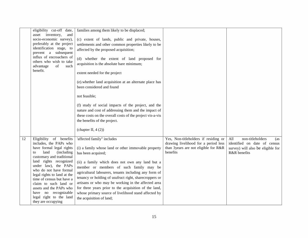
eligibility cut-off date,
asset inventory, and
socio-economic survey),
preferably at the project
identification stage, to
prevent a subsequent
influx of encroachers of
others who wish to take
advantage of such
benefit.
families among them likely to be displaced;
(c) extent of lands, public and private, houses,
settlements and other common properties likely to be
affected by the proposed acquisition;
(d) whether the extent of land proposed for
acquisition is the absolute bare minimum;
extent needed for the project
(e).whether land acquisition at an alternate place has
been considered and found
not feasible;
(f) study of social impacts of the project, and the
nature and cost of addressing them and the impact of
these costs on the overall costs of the project vis-a-vis
the benefits of the project.
(chapter II, 4 (2))
12 Eligibility of benefits
includes, the PAPs who
have formal legal rights
to land (including
customary and traditional
land rights recognized
under law), the PAPs
who do not have formal
legal rights to land at the
time of census but have a
claim to such land or
assets and the PAPs who
have no recognizable
legal right to the land
they are occupying
'affected family" includes
(i) a family whose land or other immovable property
has been acquired;
(ii) a family which does not own any land but a
member or members of such family may be
agricultural labourers, tenants including any form of
tenancy or holding of usufruct right, sharecroppers or
artisans or who may be working in the affected area
for three years prior to the acquisition of the land,
whose primary source of livelihood stand affected by
the acquisition of land;
Yes, Non-titleholders if residing or
drawing livelihood for a period less
than 3years are not eligible for R&R
benefits
All non-titleholders (as
identified on date of census
survey) will also be eligible for
R&R benefits
16
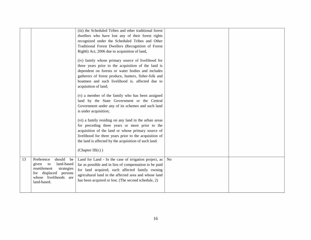
(iii) the Scheduled Tribes and other traditional forest
dwellers who have lost any of their forest rights
recognized under the Scheduled Tribes and Other
Traditional Forest Dwellers (Recognition of Forest
Righ6) Act, 2006 due to acquisition of land,
(iv) family whose primary source of livelihood for
three years prior to the acquisition of the land is
dependent on forests or water bodies and includes
gatherers of forest produce, hunters, fisher-folk and
boatmen and such livelihood is. affected due to
acquisition of land;
(v) a member of the family who has been assigned
land by the State Government or the Central
Government under any of its schemes and such land
is under acquisition;
(vi) a family residing on any land in the urban areas
for preceding three years or more prior to the
acquisition of the land or whose primary source of
livelihood for three years prior to the acquisition of
the land is affected by the acquisition of such land.
(Chapter III(c) )
13 Preference should be
given to land-based
resettlement strategies
for displaced persons
whose livelihoods are
land-based.
Land for Land - In the case of irrigation project, as
far as possible and in lieu of compensation to be paid
for land acquired, each affected family owning
agricultural land in the affected area and whose land
has been acquired or lost. (The second schedule, 2)
No
17
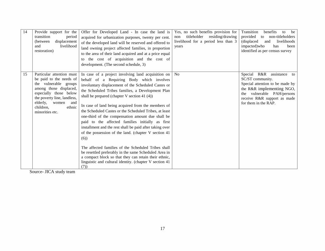
14 Provide support for the
transition period
(between displacement
and livelihood
restoration)
Offer for Developed Land - In case the land is
acquired for urbanization purposes, twenty per cent.
of the developed land will be reserved and offered to
land owning project affected families, in proportion
to the area of their land acquired and at a price equal
to the cost of acquisition and the cost of
development. (The second schedule, 3)
Yes, no such benefits provision for
non titleholder residing/drawing
livelihood for a period less than 3
years
Transition benefits to be
provided to non-titleholders
(displaced and livelihoods
impacted)who has been
identified as per census survey
15 Particular attention must
be paid to the needs of
the vulnerable groups
among those displaced,
especially those below
the poverty line, landless,
elderly, women and
children, ethnic
minorities etc.
In case of a project involving land acquisition on
behalf of a Requiring Body which involves
involuntary displacement of the Scheduled Castes or
the Scheduled Tribes families, a Development Plan
shall be prepared (chapter V section 41 (4))
In case of land being acquired from the members of
the Scheduled Castes or the Scheduled Tribes, at least
one-third of the compensation amount due shall be
paid to the affected families initially as first
installment and the rest shall be paid after taking over
of the possession of the land. (chapter V section 41
(6))
The affected families of the Scheduled Tribes shall
be resettled preferably in the same Scheduled Area in
a compact block so that they can retain their ethnic,
linguistic and cultural identity. (chapter V section 41
(7))
No Special R&R assistance to
SC/ST community.
Special attention to be made by
the R&R implementing NGO,
the vulnerable PAH/persons
receive R&R support as made
for them in the RAP.
Source- JICA study team
18
Applicability of LARR 2013 in the context of Meghalaya. 3.4
When the LARR 2013 was announced, Meghalaya along with others States in the country opposed the
Act on grounds that Meghalaya is a tribal State as per the Schedule 6 of the Indian Constitution; The
Autonomous District Councils in the State have control over the Land management in the State, however
the State Government also holds control over the Land system in Meghalaya, the two has been working
with each other to address developmental projects requiring Land . A Previous Road project in the State
has indicated that Meghalaya has on many instances utilized the LARR 2013 provisions for Land
Acquisition. The resettlement policy and entitlement proposed in this report will be adopted, keeping in
mind that the LARR 2013 may also be applicable.
19
SOCIO ECONOMIC PROFILE Chapter 4
Introduction 4.1
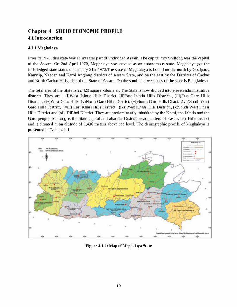
4.1.1 Meghalaya
Prior to 1970, this state was an integral part of undivided Assam. The capital city Shillong was the capital
of the Assam. On 2nd April 1970, Meghalaya was created as an autonomous state. Meghalaya got the
full-fledged state status on January 21st 1972.The state of Meghalaya is bound on the north by Goalpara,
Kamrup, Nagoan and Karbi Anglong districts of Assam State, and on the east by the Districts of Cachar
and North Cachar Hills, also of the State of Assam. On the south and westsides of the state is Bangladesh.
The total area of the State is 22,429 square kilometer. The State is now divided into eleven administrative
districts. They are: (i)West Jaintia Hills District, (ii)East Jaintia Hills District , (iii)East Garo Hills
District , (iv)West Garo Hills, (v)North Garo Hills District, (vi)South Garo Hills District,(vii)South West
Garo Hills District, (viii) East Khasi Hills District , (ix) West Khasi Hills District , (x)South West Khasi
Hills District and (xi) RiBhoi District. They are predominantly inhabited by the Khasi, the Jaintia and the
Garo people. Shillong is the State capital and also the District Headquarters of East Khasi Hills district
and is situated at an altitude of 1,496 meters above sea level. The demographic profile of Meghalaya is
presented in Table 4.1-1.
Figure 4.1-1: Map of Meghalaya State
20
Table 4.1-1: Demographic profile of Meghalaya
Description Census 2011
Population 2,966,889
- Male 1,491,832
- Female 1,475,057
Population Growth (Decadal) 27.95%
Population density Persons/ sq km 132
Sex Ratio 989
Percentage of total population of India 0.24%
Literacy 74.43 %
- Male literacy 75.95 %
- Female literacy 72.89 %
Source: Census 2011
The Legislative Assembly of Meghalaya consists of 60 members, 29 from Khasi hills, 7 from Jaintia hills,
and 24 from Garo hills. Meghalaya originally comprised of 2 districts and 3 sub divisions. In order to
accelerate the pace of development and to bring administration closer to the people, the State has been
reorganized into 11 Administrative Districts and 4 sub divisions; the whole State is covered by 39
community development blocks. There are 3 Autonomous District Councils in the State, the Jaintia Hills
Autonomous District Council, the Khasi Hills Autonomous District Council and the Garo hills
Autonomous District Council. All these ADCs are represented by members from the major tribes of the
State and are elected on the basis of adult suffrage. These councils discharge their duties and functions
assigned to them under the provisions of the Sixth Schedule of the Constitution of India.
The Meghalaya Language Act states that Khasi language may be used as the associate official language
for all purposes in, the District, Sub-Divisions and Block level offices of the State Government located in
the Districts of East Khasi. Hills,West Khasi Hills, Jaintia Hills and Ri Bhoi while English is the official
language of the State. The Garo language may be used as the associate official language for all purposes
in the districts, Sub-Divisions and Block Level Offices of East Garo Hills, West Garo Hills and South
Garo Hills:
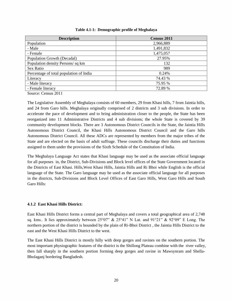
4.1.2 East Khasi Hills District:
East Khasi Hills District forms a central part of Meghalaya and covers a total geographical area of 2,748
sq. kms.. It lies approximately between 25°07” & 25°41” N Lat. and 91°21” & 92°09” E Long. The
northern portion of the district is bounded by the plain of Ri-Bhoi District , the Jaintia Hills District to the
east and the West Khasi Hills District to the west.
The East Khasi Hills District is mostly hilly with deep gorges and ravines on the southern portion. The
most important physiographic features of the district is the Shillong Plateau combine with the river valley,
then fall sharply in the southern portion forming deep gorges and ravine in Mawsynram and Shella-
Bholaganj bordering Bangladesh.
21
The headquarters of the district, Shillong is connected by the NH 44 to Guwahati of 103 kmsand Silchar
by 240 kms. The nearest Rail head and airport are situated at Guwahati. There is an airstrip suitable for
small aircrafts at Umroi which is 35 kms.fromShillong. The agricultural and other products are
transported by trucks, jeeps and tractors. Shillong is well connected with other parts of the State by
motorable road. Similarly, all the block headquarters in the district are also connected by roads. However,
the villages in the interior areas are poorly connected and transport services are inadequate. The
demographic profile of East Khasi Hills is presented in Table 4.1-2.
Figure 4.1-2: Map of East Khashi Hills District
Table 4.1-2: Demographic profile of East Khasi Hills district
Description 2011 Census
Population 825,922
- Male 410,749
- Female 415,173
Households 163,397
Population Density 301
Literacy 84.15 %
- Male Literacy 84.51%
- Female Literacy 83. 81%
No of CD Blocks 8
No of Villages 975
Source: Census 2011
22
There are 8 Development Blocks in the East Khasi Hills District, viz
1 KhatarshnongLaitkroh 98 villages
2 Mawkynrew 71 Villages
3 Mawphlang 184 Villages
4 Mawryngkneng 64 Villages
5 Mawsynram 166 Villages
6 Mylliem 109 Villages
7 Pynursla 156 Villages
8 ShellaBholaganj 140 Villages
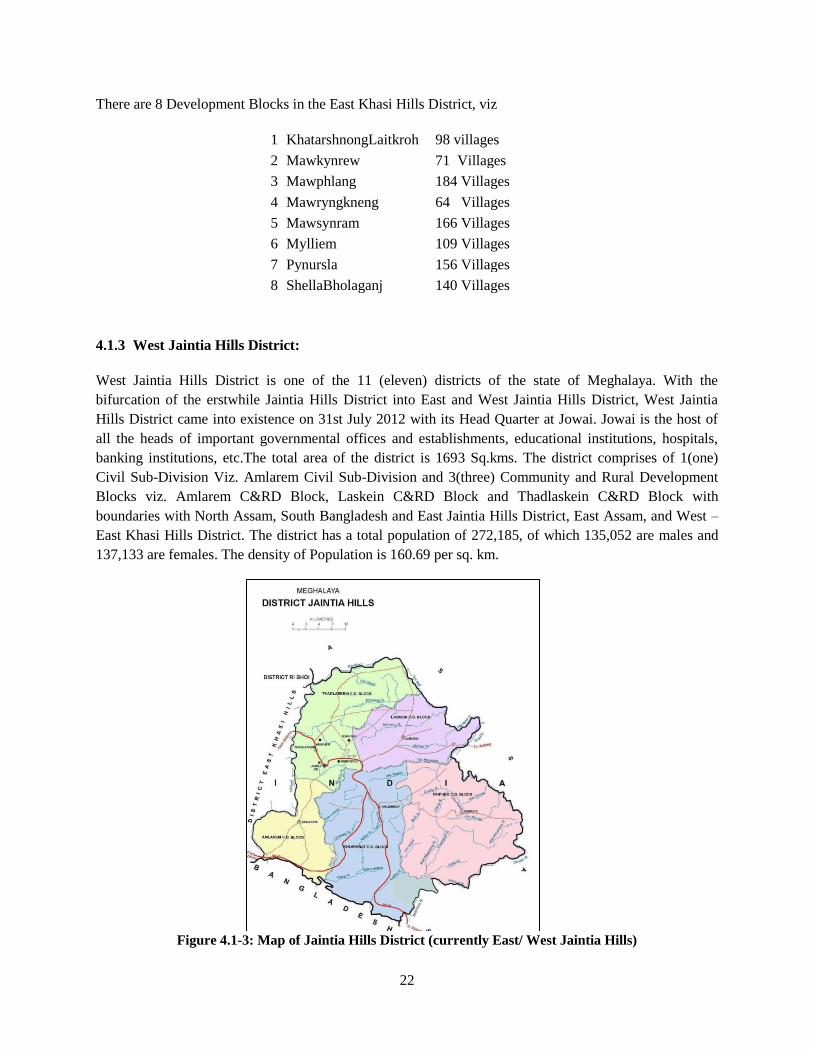
4.1.3 West Jaintia Hills District:
West Jaintia Hills District is one of the 11 (eleven) districts of the state of Meghalaya. With the
bifurcation of the erstwhile Jaintia Hills District into East and West Jaintia Hills District, West Jaintia
Hills District came into existence on 31st July 2012 with its Head Quarter at Jowai. Jowai is the host of
all the heads of important governmental offices and establishments, educational institutions, hospitals,
banking institutions, etc.The total area of the district is 1693 Sq.kms. The district comprises of 1(one)
Civil Sub-Division Viz. Amlarem Civil Sub-Division and 3(three) Community and Rural Development
Blocks viz. Amlarem C&RD Block, Laskein C&RD Block and Thadlaskein C&RD Block with
boundaries with North Assam, South Bangladesh and East Jaintia Hills District, East Assam, and West –
East Khasi Hills District. The district has a total population of 272,185, of which 135,052 are males and
137,133 are females. The density of Population is 160.69 per sq. km.
Figure 4.1-3: Map of Jaintia Hills District (currently East/ West Jaintia Hills)
23
Table 4.1-3: Demographic profile of West Jaintia Hills district
Description 2011 Census
Population 272,185
- Male 135,052
- Female 137,133
Households 45,272
Population Density 160
Literacy 63.12 %
- Male Literacy 58.51%
- Female Literacy 67.61. %
No of CD Blocks 3
No of Villages 331
Source: Census 2011
(extracted data of CD Blocks currently belongs to West Jaintia Hills)
Socio Economic Profile of Meghalaya-East Khasi Hills and Jaintia Hills Districts 4.2
4.2.1 Project District population and percentage of SC and ST
Following Table 4.2-1 presents project district Scheduled Tribe and Schedule Cast population and
percentage.
Table 4.2-1: District wise population and percentage of SC and ST
State /
district name
ST SC Others Total % ST % SC % others
Meghalaya 2,555,861 17,355 393,673 2,966,889 86.15 0.58 13.27
East Khasi
Hills
661,158 5 ,642 159,122 825,922 80.05 0.68 19.27
Wesr Jaintia
Hills
257,941 844 13,400 272,185 94.77 0.31 4.92
Source: Census 2011
(extracted data of CD Blocks currently belongs to West Jaintia Hills)
4.2.2 Poverty and Human Development scenario
Following Table 4.2-2 presents project district poverty and human development scenario.
24
Table 4.2-2: Poverty and Human Development scenario
District name Total HH BPL HH BPL % Rank in no. of BPL
HH
East Khasi Hills 1,09,115 50,997 46.74 5
Jaintia Hills 49,771 19,663 39.51 7
Source: BPL Census, 2002
4.2.3 Project District per Capita Income
Following Table 4.2-3 presents project districts per capita income
Table 4.2-3: District wise Per Capita Income
Year East Khasi Hills Jaintia Hills
1999 - 2000 21,084 19,932
2003 - 2004 25,659 23,246
2007 - 2008 31,202 26,015
Source: Directorate of Economics & Statistics, Meghalaya
4.2.4 Human Development Index
Following Table 4.2-4 presents project district HDI.
Table 4.2-4: District wise HDI
State /
District
Infant
Mortality
Rate
Literacy Combined
GER
NSDP Per Capita
per current prise
(₹)
HDI HDI Rank
Meghalaya 52.28 63.31 62.87 17595 0.585 26*
East Khasi
Hills
34.51 74.74 63.10 24793 0.676 1
Jaintia Hills 77.34 53.00 43.31 20405 0.469 5
*rank in country
4.2.5 Scheduled Tribe in Project Districts
80.05% of population in East Khasi Hills are Scheduled Tribes, of which 90.60% are Khasi or its ethno-
historically related tribes. 95.97% of population in Jaintia Hills are Scheduled Tribes, of which 89.18%
are Khasi, Jaintia or its ethno-historically close tribes.
25
Table 4.2-5: District wise Scheduled Tribes
State /
District
All
Schedule
Tribes
Garo Hajong Khasi,
Jaintia,
Synteng,
Pnar,
War,
Bhoi,
Lyngngam
Koch Any
Kuki
Tribes
Mikir Raba,
Rava
Other
ST
Meghalaya 2,555,861 821,026 38,576 1,411,775 22,716 14,275 19,289 32,662 195,542
East Khasi
Hills
661,158 23,481 3,244 599,025 445 2,810 3,339 410 28,304
Jaintia Hills 376,099 488 20 335422 3 8807 1026 23 30,310
(1) Khasi/ Jaintia Tribe
The term Khasi is applied to the group of matrilineal and Mon-Khmer speaking people who
contemporarily inhabit the Khasi Hills and Jaintia Hills districts of Meghalaya State. It is generally
considered by many Khasi sociologists that the Khasi Tribe consists of seven sub-tribes, hence the title
'Children of the Seven Huts': Khynriam, Pnar, Bhoi, War, Maram, Lyngngam and Diko. The Khynriam
(or Nongphlang) inhabit the uplands of the East Khasi Hills District; the Pnar or Syntengs live in the
uplands of the Jaintia Hills. The Bhoi live in the lower hills to the north and north-east of the Khasi Hills
and Jaintia Hills towards the Brahmaputra valley. The War, usually divided into War-Jaintia in the south
of the Jaintia Hills and War-Khasi in the south of the Khasi Hills, live on the steep southern slopes
leading to Bangladesh. The Marams inhabit the uplands of the West Khasi Hills Districts. The Lyngngam
people who inhabit the western parts of the Khasi Hills bordering the Garo Hills display linguistic and
cultural characteristics which show influences from both the Khasis to their east and the Garo people to
the west.
The Jaintia tribe is in fact a sub tribe tribe of the Khasis; With time, The Jaintias was befitted as a
major tribe , because of their dominance in population and because of their inhabitance in a major part of
the Khasi Hills and the whole of Jaintia hills area of the State . They are also known as “Pnar”, they speak
the Jaintia language which is different from the Khasi language.
Language: The Khasi language is believed to be one of the very few surviving dialects of the
Monkumer family of languages in India.. The Khasi language was essentially oral until the arrival of
Christian missionaries. Particularly significant in this regard was a Welsh evangelist, Thomas Jones, who
transcribed the Khasi language into the Roman script. While the main language for communication is in
Khasi, the sub tribes have dialects of their own, and usually communicate in Khasi only when they are
communicating with another sub tribe and with the major tribe, referred to as the “khynriam”. Religion: The Khasi people form the majority of the population of the eastern part of Meghalaya, and
are the state's largest community. Though the majority of the 85.00 % Khasi populace have embraced
Christianity, a substantial minority of the Khasi people still follow and practice their age old indigenous
religion, which is known as "Ka Niam Khasi" and it is their belief that the rooster (U Syiar Khraw
Jutang) is sacrificed as a substitute for man, it being thought that the rooster "bears the sins of men and
26
by its sacrifice, man will obtain redemption. A small number of Khasis, as a result of inter-community
marriages, are also Muslims. There is also a very small number of Khasi Hindus inhabiting the Jaintia
Hills of Meghalaya, a result of hundreds of years of exposure to the plains of Bengal and Assam.
Culture: The Khasis follow the matrilineal system of society. Here, the lineage of the tribe is traced
through the woman. The children take the name of the mother and their children continue to do the same.
Ancestral property is passed down to the youngest daughter (kaKhatduh), and to the daughter elder to the
Khatduh, if the Khatduhdies or marries a non Khasi/takes the name of her husband. Although the woman
in this society is secured with the ancestral property, it is the man, usually the eldest brother, or the
maternal uncle who decides on the management of the property. The husband is the bread earner and
holds the final decisions in matters of his immediate family, and also in his Mother’s family as the
maternal uncle. The Khasisfollow the matri local type of residence, where the man stays in the woman’s
house after marriage.
Khasi and Jaintia Traditional Institutions is shown in Figure 4.2-1 and Figure 4.2-2 respectively.
Figure 4.2-1: Khasi Traditional Institutions Figure 4.2-2: Jaintia Traditional Institutions
Source: B. K. Tiwari ‘Institutional Arrangements for Preservation and Management of Community
Forests of North-East India’
(2) Garo Tribe
In RAP survey, it was observed that a few Garo people could be affected by the Project. The Garo, of
Tibeto-Burman origin, address themselves as A’chik or Mande. The Garo is matrilineal society, where
the land can be only inherited through the women of the families. The traditional Garo religion includes
the belief of supernatural spirits called mite. They believed that these spirits lived in the jungle and caused
diseases. They also believed in important gods that overlooked the growth of the crops. Today, majority
of the population have been converted to Christianity.
Garo Traditional Institutions is shown in Figure 3.
Hima (Lager Territory)
Siem Hima (cheif)
Raid (Smaller Territory)
Siem Raid (cheif)
Shnong (Village Base)
Rangbah Shnong (headman)
Kur (Clan Base)
Rangbah Kur (headman)
Ing (FamilyBase)
Elaka (province)
Doloi' (cheif)
U Basan (advisor to Doloi)
Chnong (Village Base)
Rangbah Chnong (headman)
Kur (Clan Base)
Rangbah Kur (headman)
Ing (FamilyBase)
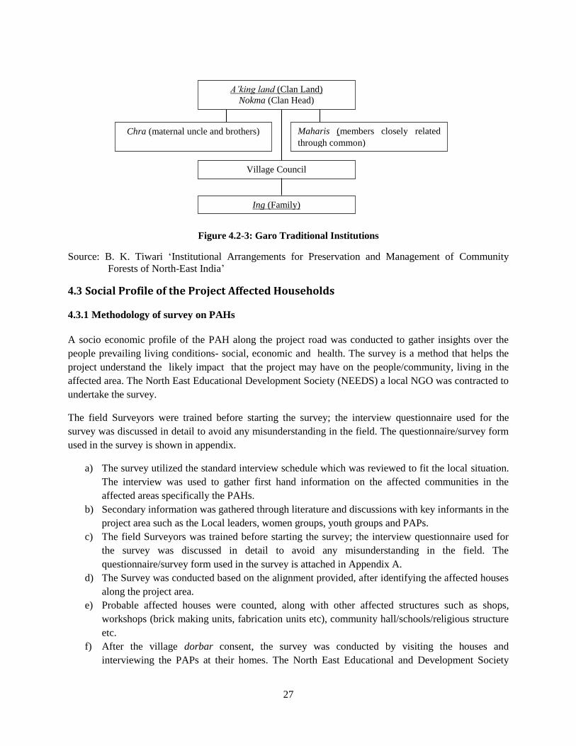
27
Figure 4.2-3: Garo Traditional Institutions
Source: B. K. Tiwari ‘Institutional Arrangements for Preservation and Management of Community
Forests of North-East India’
Social Profile of the Project Affected Households 4.3
4.3.1 Methodology of survey on PAHs
A socio economic profile of the PAH along the project road was conducted to gather insights over the
people prevailing living conditions- social, economic and health. The survey is a method that helps the
project understand the likely impact that the project may have on the people/community, living in the
affected area. The North East Educational Development Society (NEEDS) a local NGO was contracted to
undertake the survey.
The field Surveyors were trained before starting the survey; the interview questionnaire used for the
survey was discussed in detail to avoid any misunderstanding in the field. The questionnaire/survey form
used in the survey is shown in appendix.
a) The survey utilized the standard interview schedule which was reviewed to fit the local situation.
The interview was used to gather first hand information on the affected communities in the
affected areas specifically the PAHs.
b) Secondary information was gathered through literature and discussions with key informants in the
project area such as the Local leaders, women groups, youth groups and PAPs.
c) The field Surveyors was trained before starting the survey; the interview questionnaire used for
the survey was discussed in detail to avoid any misunderstanding in the field. The
questionnaire/survey form used in the survey is attached in Appendix A.
d) The Survey was conducted based on the alignment provided, after identifying the affected houses
along the project area.
e) Probable affected houses were counted, along with other affected structures such as shops,
workshops (brick making units, fabrication units etc), community hall/schools/religious structure
etc.
f) After the village dorbar consent, the survey was conducted by visiting the houses and
interviewing the PAPs at their homes. The North East Educational and Development Society
Chra (maternal uncle and brothers) Maharis (members closely related
through common)
Village Council
Ing (Family)
A’king land (Clan Land)
Nokma (Clan Head)
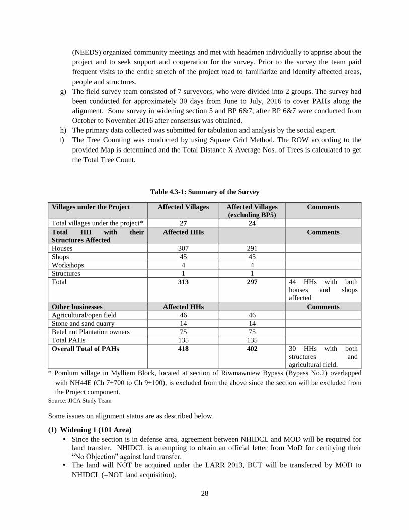
28
(NEEDS) organized community meetings and met with headmen individually to apprise about the
project and to seek support and cooperation for the survey. Prior to the survey the team paid
frequent visits to the entire stretch of the project road to familiarize and identify affected areas,
people and structures.
g) The field survey team consisted of 7 surveyors, who were divided into 2 groups. The survey had
been conducted for approximately 30 days from June to July, 2016 to cover PAHs along the
alignment. Some survey in widening section 5 and BP 6&7, after BP 6&7 were conducted from
October to November 2016 after consensus was obtained.
h) The primary data collected was submitted for tabulation and analysis by the social expert.
i) The Tree Counting was conducted by using Square Grid Method. The ROW according to the
provided Map is determined and the Total Distance X Average Nos. of Trees is calculated to get
the Total Tree Count.
Table 4.3-1: Summary of the Survey
Villages under the Project Affected Villages Affected Villages
(excluding BP5)
Comments
Total villages under the project* 27 24
Total HH with their
Structures Affected
Affected HHs Comments
Houses 307 291
Shops 45 45
Workshops 4 4
Structures 1 1
Total 313 297 44 HHs with both
houses and shops
affected
Other businesses Affected HHs Comments
Agricultural/open field 46 46
Stone and sand quarry 14 14
Betel nut Plantation owners 75 75
Total PAHs 135 135
Overall Total of PAHs 418 402 30 HHs with both
structures and
agricultural field.
* Pomlum village in Mylliem Block, located at section of Riwmawniew Bypass (Bypass No.2) overlapped
with NH44E (Ch 7+700 to Ch 9+100), is excluded from the above since the section will be excluded from
the Project component.
Source: JICA Study Team
Some issues on alignment status are as described below.
(1) Widening 1 (101 Area)
Since the section is in defense area, agreement between NHIDCL and MOD will be required for
land transfer. NHIDCL is attempting to obtain an official letter from MoD for certifying their
“No Objection” against land transfer.
The land will NOT be acquired under the LARR 2013, BUT will be transferred by MOD to
NHIDCL (=NOT land acquisition).
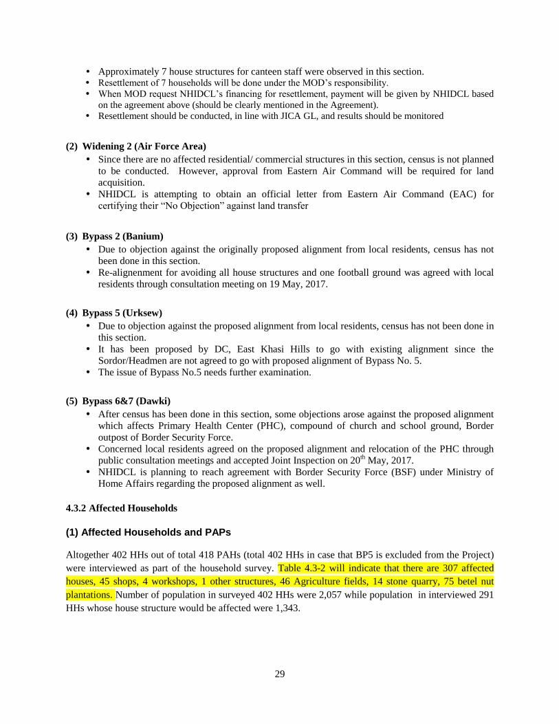
29
Approximately 7 house structures for canteen staff were observed in this section. Resettlement of 7 households will be done under the MOD’s responsibility.
When MOD request NHIDCL’s financing for resettlement, payment will be given by NHIDCL based
on the agreement above (should be clearly mentioned in the Agreement).
Resettlement should be conducted, in line with JICA GL, and results should be monitored
(2) Widening 2 (Air Force Area)
Since there are no affected residential/ commercial structures in this section, census is not planned
to be conducted. However, approval from Eastern Air Command will be required for land
acquisition.
NHIDCL is attempting to obtain an official letter from Eastern Air Command (EAC) for
certifying their “No Objection” against land transfer
(3) Bypass 2 (Banium)
Due to objection against the originally proposed alignment from local residents, census has not
been done in this section.
Re-alignenment for avoiding all house structures and one football ground was agreed with local
residents through consultation meeting on 19 May, 2017.
(4) Bypass 5 (Urksew)
Due to objection against the proposed alignment from local residents, census has not been done in
this section.
It has been proposed by DC, East Khasi Hills to go with existing alignment since the
Sordor/Headmen are not agreed to go with proposed alignment of Bypass No. 5.
The issue of Bypass No.5 needs further examination.
(5) Bypass 6&7 (Dawki)
After census has been done in this section, some objections arose against the proposed alignment
which affects Primary Health Center (PHC), compound of church and school ground, Border
outpost of Border Security Force.
Concerned local residents agreed on the proposed alignment and relocation of the PHC through
public consultation meetings and accepted Joint Inspection on 20th May, 2017.
NHIDCL is planning to reach agreement with Border Security Force (BSF) under Ministry of
Home Affairs regarding the proposed alignment as well.
4.3.2 Affected Households
(1) Affected Households and PAPs
Altogether 402 HHs out of total 418 PAHs (total 402 HHs in case that BP5 is excluded from the Project)
were interviewed as part of the household survey. Table 4.3-2 will indicate that there are 307 affected
houses, 45 shops, 4 workshops, 1 other structures, 46 Agriculture fields, 14 stone quarry, 75 betel nut
plantations. Number of population in surveyed 402 HHs were 2,057 while population in interviewed 291
HHs whose house structure would be affected were 1,343.
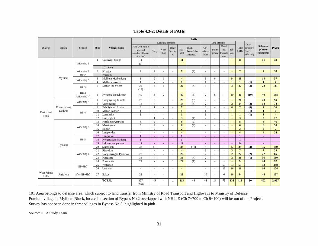
31
Table 4.3-2: Details of PAHs
101 Area belongs to defense area, which subject to land transfer from Ministry of Road Transport and Highways to Ministry of Defense.
Pomlum village in Mylliem Block, located at section of Bypass No.2 overlapped with NH44E (Ch 7+700 to Ch 9+100) will be out of the Project.
Survey has not been done in three villages in Bypass No.5, highlighted in pink.
Source: JICA Study Team
HHs with house
affected
(number of house
structure)
ShopWork-
shop
Other
Structur
e
Sub-
total
(both
house/ shop
affected)
Agri-
culture
fields
Stone
quarry
Betel
nut
Plantati
ons
Sub-
total
1 Umshyrpi bridge 11 - - - 11 - - - - 11 11 48
(3)
101 Area
Widening 2 2 5th mile 7 7 - - 7 (7) - - - - 7 7 38
BP 2 Pomlum
3 Mylliem Marbaniang 1 2 1 4 8 6 14 18 18 57
4 Mylliem mawrie 1 - - - 1 1 - - 1 1 (1) 1 4
5 Madan ing Syiem 22 3 1 - 22 (4) 3 - - 3 22 (3) 22 111
(19)
(BP3
-Widening 4)6 Kyndong Nongkyntir 40 3 2 - 40 (5) 2 8 - 10 40 (10) 40 168
7 Umlympung 12 mile 20 3 - 20 (3) - - - - 20 20 95
8 Umtyngngar 14 4 - - 14 (4) 2 - - 2 14 (2) 14 74
9 Beh Syiem 15 mile 6 1 - - 7 6 - - 6 7 (6) 7 36
10 Madan Panpoh 1 - - - 1 1 - - 1 1 (1) 1 9
11 Lumshalla 1 - - - 1 1 - - 1 1 (1) 1 4
12 Laitlyngkot 3 1 - - 3 (1) - - - - 3 3 17
13 Pomlum (Pynursla) 8 2 - - 8 (2) - - - - 8 8 46
14 Mawkajem 6 2 - - 6 (2) - - - - 6 6 30
15 Rngain - 2 - 2 - 2 2 7
16 Langkyrdem 4 - - - 4 - - - - 4 4 24
17 Langkawet 1 - - - 1 - - - - 1 -
18 Nongmadan Shadsngi 1 - - - 1 - - - - 1 -
19 Urksew wahpathaw 14 - - - 14 - - - - 14 -
20 Siatbakon 33 11 - - 33 (11) 5 - - 5 35 (3) 35 169
21 Risawkur 4 - - - 4 3 - - 3 7 7 29
22 Nongshyrngan Pynursla 22 - - - 22 2 - - 2 22 (2) 22 85
23 Pongtung 35 4 - - 35 (4) 2 - - 2 36 (1) 36 160
24 Pomshutia 24 - - 1 24 (1) - - - - 24 24 97
25 Wahkdait - 53 53 53 53 448
26 Umsyiem - - - - - - - 16 16 16 16 104
West Jaintia
HillsAmlarem after BP 6&7 27 Bakur 28 - - 28 10 - 6 16 44 44 197
TOTAL 307 45 4 1 313 44 46 14 75 135 418 30 402 2,057
(296)
Mylliem
Section
Widening 1
(both
structure
/land
affected)
Villages NameSl no
Land affected
Widening 3
Khatarshnong
Laitkroh
Total
PAHs
Structure affected
BP 6&7
Pynursla
East Khasi
Hills
PAPsSub-total
(Census
conducted)
PAHs
Widening 5
BP 5
BlockDistrict
Widening 6
BP 3
Widening 4
BP 4
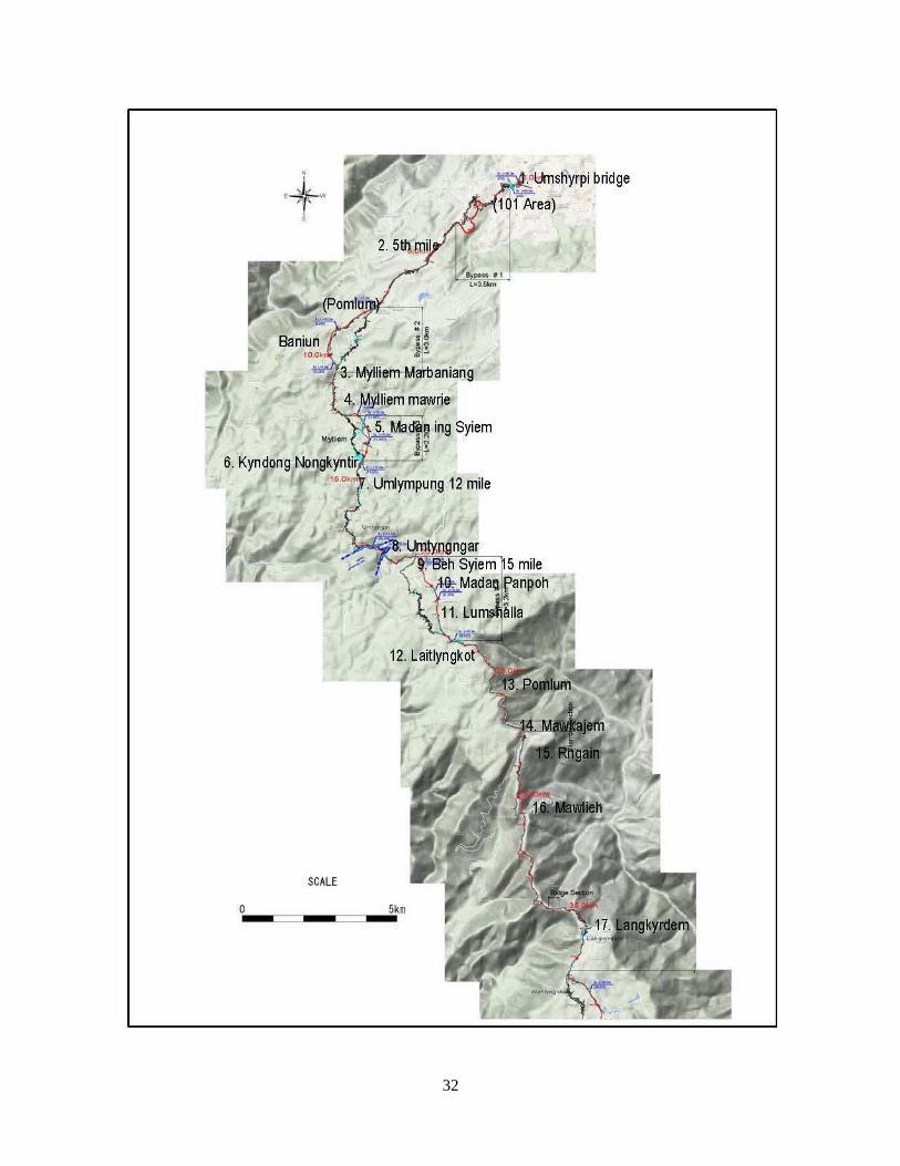
32
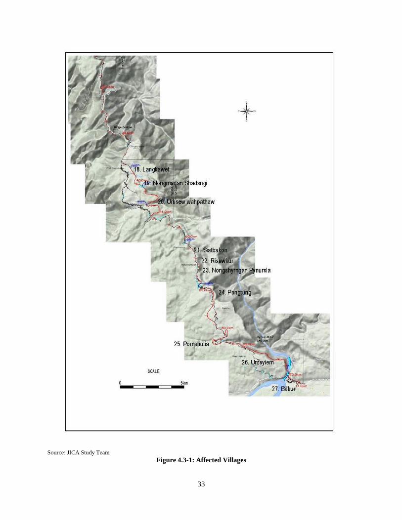
33
Source: JICA Study Team Figure 4.3-1: Affected Villages
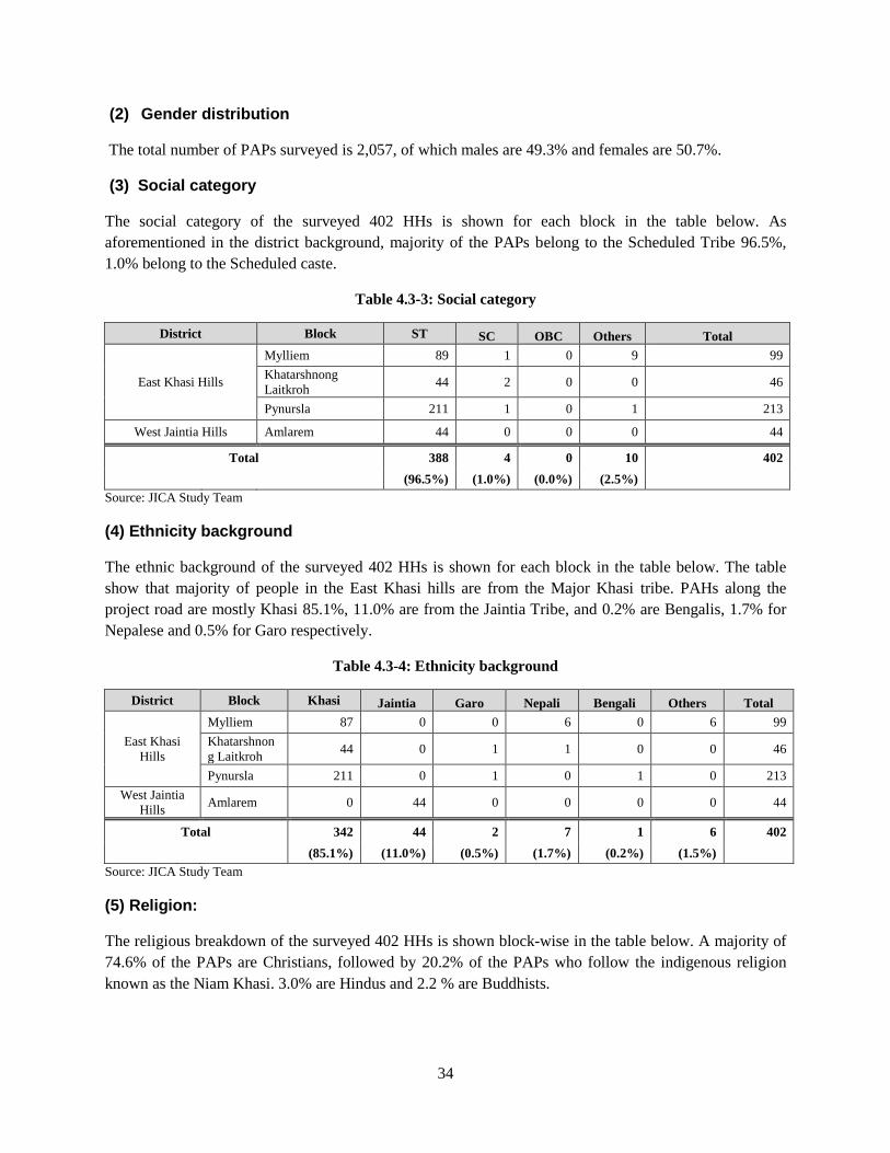
34
(2) Gender distribution
The total number of PAPs surveyed is 2,057, of which males are 49.3% and females are 50.7%.
(3) Social category
The social category of the surveyed 402 HHs is shown for each block in the table below. As
aforementioned in the district background, majority of the PAPs belong to the Scheduled Tribe 96.5%,
1.0% belong to the Scheduled caste.
Table 4.3-3: Social category
District Block ST SC OBC Others Total
East Khasi Hills
Mylliem 89 1 0 9 99
Khatarshnong
Laitkroh 44 2 0 0 46
Pynursla 211 1 0 1 213
West Jaintia Hills Amlarem 44 0 0 0 44
Total 388 4 0 10 402
(96.5%) (1.0%) (0.0%) (2.5%)
Source: JICA Study Team
(4) Ethnicity background
The ethnic background of the surveyed 402 HHs is shown for each block in the table below. The table
show that majority of people in the East Khasi hills are from the Major Khasi tribe. PAHs along the
project road are mostly Khasi 85.1%, 11.0% are from the Jaintia Tribe, and 0.2% are Bengalis, 1.7% for
Nepalese and 0.5% for Garo respectively.
Table 4.3-4: Ethnicity background
District Block Khasi Jaintia Garo Nepali Bengali Others Total
East Khasi
Hills
Mylliem 87 0 0 6 0 6 99
Khatarshnon
g Laitkroh 44 0 1 1 0 0 46
Pynursla 211 0 1 0 1 0 213
West Jaintia
Hills Amlarem 0 44 0 0 0 0 44
Total 342 44 2 7 1 6 402
(85.1%) (11.0%) (0.5%) (1.7%) (0.2%) (1.5%)
Source: JICA Study Team
(5) Religion:
The religious breakdown of the surveyed 402 HHs is shown block-wise in the table below. A majority of
74.6% of the PAPs are Christians, followed by 20.2% of the PAPs who follow the indigenous religion
known as the Niam Khasi. 3.0% are Hindus and 2.2 % are Buddhists.
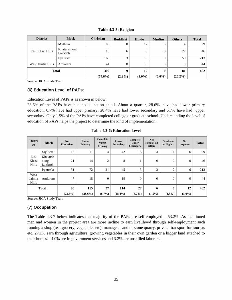
35
Table 4.3-5: Religion
District Block Christian Buddhist Hindu Muslim Others Total
East Khasi Hills
Mylliem 83 0 12 0 4 99
Khatarshnong
Laitkroh 13 6 0 0 27 46
Pynursla 160 3 0 0 50 213
West Jaintia Hills Amlarem 44 0 0 0 0 44
Total 300 9 12 0 81 402
(74.6%) (2.2%) (3.0%) (0.0%) (20.2%)
Source: JICA Study Team
(6) Education Level of PAPs:
Education Level of PAPs is as shown in below.
23.6% of the PAPs have had no education at all. About a quarter, 28.6%, have had lower primary
education, 6.7% have had upper primary, 28.4% have had lower secondary and 6.7% have had upper
secondary. Only 1.5% of the PAPs have completed college or graduate school. Understanding the level of
education of PAPs helps the project to determine the kind of implementation.
Table 4.3-6: Education Level
Distri
ct Block
No
Education
Lower
Primary
Complete
Upper
Primary
Lower
Secondary
Complete
Upper
Secondary
Not
complet-ed
college
Graduate
or Higher
No
response Total
East
Khasi
Hills
Mylliem 16 11 4 42 13 3 4 6 99
Khatarsh
nong
Laitkroh
21 14 2 8 1 0 0 0 46
Pynursla 51 72 21 45 13 3 2 6 213
West
Jaintia
Hills
Amlarem 7 18 0 19 0 0 0 0 44
Total 95 115 27 114 27 6 6 12 402
(23.6%) (28.6%) (6.7%) (28.4%) (6.7%) (1.5%) (1.5%) (3.0%)
Source: JICA Study Team
(7) Occupation
The Table 4.3-7 below indicates that majority of the PAPs are self-employed – 53.2%. As mentioned
men and women in the project area are more incline to earn livelihood through self-employment such
running a shop (tea, grocery, vegetables etc), manage a sand or stone quarry, private transport for tourists
etc. 27.1% earn through agriculture, growing vegetables in their own garden or a bigger land attached to
their homes. 4.0% are in government services and 3.2% are unskilled laborers.
36
Table 4.3-7: Occupation
Dist. Block
Agriculture/
Allied
Agriculture
Dairy
Household
/cottage
Industry
Self
Employed
Skilled
Profession
Unskilled
Labor
Private
Service
Gov.
Service
Other/ No
response Total
East
Khasi
Hills
Mylliem 9 0 2 65 2 1 0 11 9 99
Khatarshnon
g Laitkroh 11 1 2 22 1 3 0 1 5 46
Pynursla 70 1 2 103 0 9 3 4 21 213
West
Jaintia
Hills
Amlarem 19 0 0 24 0 0 0 0 1 44
Total 109 2 4 214 3 13 3 16 36 402
(27.1%) (0.5%) (1.5%) (53.2%) (0.8%) (3.2%) (0.8%) (4.0%) (8.9%)
Source: JICA Study Team
(8) Total monthly household income of H/H from all sources : Table 4.3-8 below indicates the total monthly income of the PAH. 12.7 % of the PAPs have a monthly
income that falls within Rs 7,001-9000/- followed by those earning between Rs 5,001 to 7,000. Only
0.7% earn a monthly income that is below Rs 1000/-, while 17.4% have a total monthly income that is
above Rs 21,000/-.
Table 4.3-8: Total monthly household income of H/H from all sources (INR/month)
Dist.t Block Below
1000
1001
-
3000
3001
-
5000
5001
-
7000
7001
-
9000
9001
-
11000
11000
-
13000
13001
-
15000
15001
-
17000
17001
-
19000
19001
-
21000
above
21000
No res-
ponse Total
East
Khasi
Hills
Mylliem 0 0 5 11 14 8 7 8 7 0 8 24 7 99
Khatarshn
ong
Laitkroh
0 1 14 8 9 4 2 2 1 0 1 4 0 46
Pynursla 3 3 22 26 24 20 6 7 11 20 26 32 13 213
West Jaintia
Hills
Amlarem 0 0 5 4 4 9 5 5 1 1 0 10 0 44
Total 3 4 46 49 51 41 20 22 20 21 35 70 20 402
(0.7%) (1.0%) (11.4%) (12.2%) (12.7%) (10.2%) (5.0%) (5.5%) (5.0%) (5.2%) (8.7%) (17.4%) (5.0%)
Source: JICA Study Team
(9) Number of employed members in a PAH.
Out of 2,057 PAPs, 39.3% are employed and 11.1% are unemployed, while 11.3% are involved in
housework.
37
Table 4.3-9: Number of employed members in a PAH
District Block Employed Unemployed Housework Students unknown Total
East Khasi Hills
Mylliem 160 51 47 168 0 426
Khatarshnong
Laitkroh 87 35 17 96 0 235
Pynursla 479 130 133 434 23 1,199
West Jaintia Hills Amlarem 84 13 35 66 0 197
Total 809 229 232 764 23 2,057
(39.3%) (11.1%) (11.3%) (37.1%) (1.1%)
Source: JICA Study Team
(10) Public amenities:
Table 4.3-10 indicates that 86.8 % of PAHs are connected to power supply. However it is learnt that the
supply of power is not regular and people continue keep traditional lanterns to light their homes. Hence, a
large number of people continue to use firewood to cook their food.
Toilets are available with 85.8% of the affected people.
Table 4.3-10: Public amenities
Public infra Available Not available No response
Electricity 86.8% 1.7% 11.5%
Toilets 85.8% 4.5% 9.7%
House condition - - -
Source: JICA Study Team
(11) Cooking fuel People in remote Meghalaya, and in reference to this area where the project will be implemented,
continue to use firewood and charcoal as a source of fuel for cooking and also for heating. Firewood is
still used as fuel for cooking. There are few people using gas for cooking fuel.
Shops that sell tea and local food are also more inclined to use charcoal or firewood as cooking fuel. One
of the common reasons for this trend, is the inconsistent supply of power supply in the area and the belief
that food and tea tastes much better when cooked slowly over firewood or charcoal.
(12) Water source
The community along the project area does not have a total house connection of water supply. Only A
few PAHs have the luxury of -direct to house water connection. The almost PAHs have to depend on
other alternatives of water supply which is mostly private supply stored in a tank within their compond
( water is bought from private suppliers , or the PAPs themselves collect the water from the source- river,
rock/hillocks.) Less than 20% the PAPs collect water from stand post (the community main source
through the hand pump or the community tap.)
38
(13) Livestock
About 30% of the PAPs own or rear livestock, which includes cows, pigs, poultry sheep and goats. It is
apparent that almost half the number of PAPs are continuing with traditional practices of rearing livestock
at home. The main animal reared by the PAP is the pig, the poultry, and cattle. These animals are reared
both for income generation purpose and also for own consumption. Livestock farming of the PAPs is not
very feasible, due to lack of space, capital and time, yet it continues because beside for own consumption,
livestock farming is a way of life to the tribal group in the State of Meghalaya.
(14) Health
Diseases such as diarrhea cold and flu seem to be the most common that people in the project area gets
affected from. A few had suffered from Leukemia. Both Government and private Hospitals are accessed
by the PAPs, depending upon the severity of the disease. Local traditional practitioners on various counts
are the primary referral where people feel convenient to go to because of availability and flexibility.
(15) Ownership of houses/ Land ownership:
The ownership of houses/shops indicates 81.1% are self-owned and 13.4% are staying on rent.
Majority is 37.8% HHs of private land out of 402 HHs, followed by 34.3% of village council pass.
Table 4.3-11: Ownership of Structure
District Block Owned Rented No response Total
East Khasi Hills Mylliem 52 27 3 82
Khatarshnong Laitkroh 39 5 1 45
Pynursla 124 3 12 136
West Jaintia Hills Amlarem 24 4 0 28
Total 236 39 16 291
(81.1%) (13.4%) (5.5%)
Source: JICA Study Team
Table 4.3-12: Land System
District Block
Private Land
with Land
Settlement
Certificates
Periodic
Patta
Home
Site
Village
Council
Pass
Gov. Land
(defence/
cantonment)
Others No
response Total
East Khasi
Hills
Mylliem 48 15 1 5 11 1 18 99
Khatarshnong Laitkroh
24 2 14 0 0 5 1 46
Pynursla 56 14 7 118 0 7 11 213
West
Jaintia Hills
Amlarem 24 2 0 15 0 0 3 44
Total 152 33 22 138 11 13 33 402
(37.8%) (8.2%) (5.5%) (34.3%) (2.8%) (3.2%) (8.2%)
Source: JICA Study Team
39
(16). Vulnerability:
17.9% of HHs are headed by a female. 21.6% of HH are headed by the persons over 55 years old. 13.2%
are BPL.
Table 4.3-13: Vulnerability
District Block Female HH HH above 55 Minority Below Poverty
Line
Total
Vulnerable
Total
HHs
East Khasi Hills
Mylliem 36 20 6 5 54 99
Khatarshnong
Laitkroh 3 11 1 15 26 46
Pynursla 28 42 1 28 85 213
West Jaintia Hills Amlarem 5 14 0 5 21 44
Total 72 87 8 53 171 402
(17.9%) (21.6%) (2.0%) (13.2%) (46.3%)
Source: JICA Study Team
4.3.3 Socio-economic status of villages in BP2 and BP5
Northern half of Riwmawniew Bypass (Bypass No.2) , the section overlapped with NH44E (Ch 7+700 to
Ch 9+100) , will be excluded from the Project component. Pynursla Bypass (Bypass No.5) might be
excluded from the Project component as the alignment has been not yet agreed with local residents.
Outline of socio-economic status of Pomlum located in Bypass No. 2, and Langkawet, Nongmadan
Shadsngi, Urksew Wahpathaw located in Bypass No.2 is as shown below.
Table 4.3-14: Socio-economic status of villages in BP2 and BP5
Distric
t
4.3.4 District
Block
4.3.5 Block
Village
4.3.6 Village
Locatio
n
4.3.7 Location
Schedule
d
Cast
Scheduled
Tribe
Literac
y
4.3.8 Literacy
Work
Populatio
n
4.3.9
Work
Agri-
cultur
e
HH
industr
y
Other
East
Khasi
Hills
Myllie
m
Pomlum BP2 0.6% 91.5% 80.5% 34.5% 18.4% 2.7% 78.9
%
Pynursl
a
Langkawet BP5 0.0% 100.0% 68.2% 31.0% 69.0% 0.0% 31.0
%
Nongmada
n Shadsngi
BP5 0.0% 100.0% 89.0% 37.3% 10.9% 0.6% 76.7
%
Urksew
Wahpatha
w
BP5 0.1% 99.8% 88.1% 32.7% 15.6% 2.7% 76.8
%
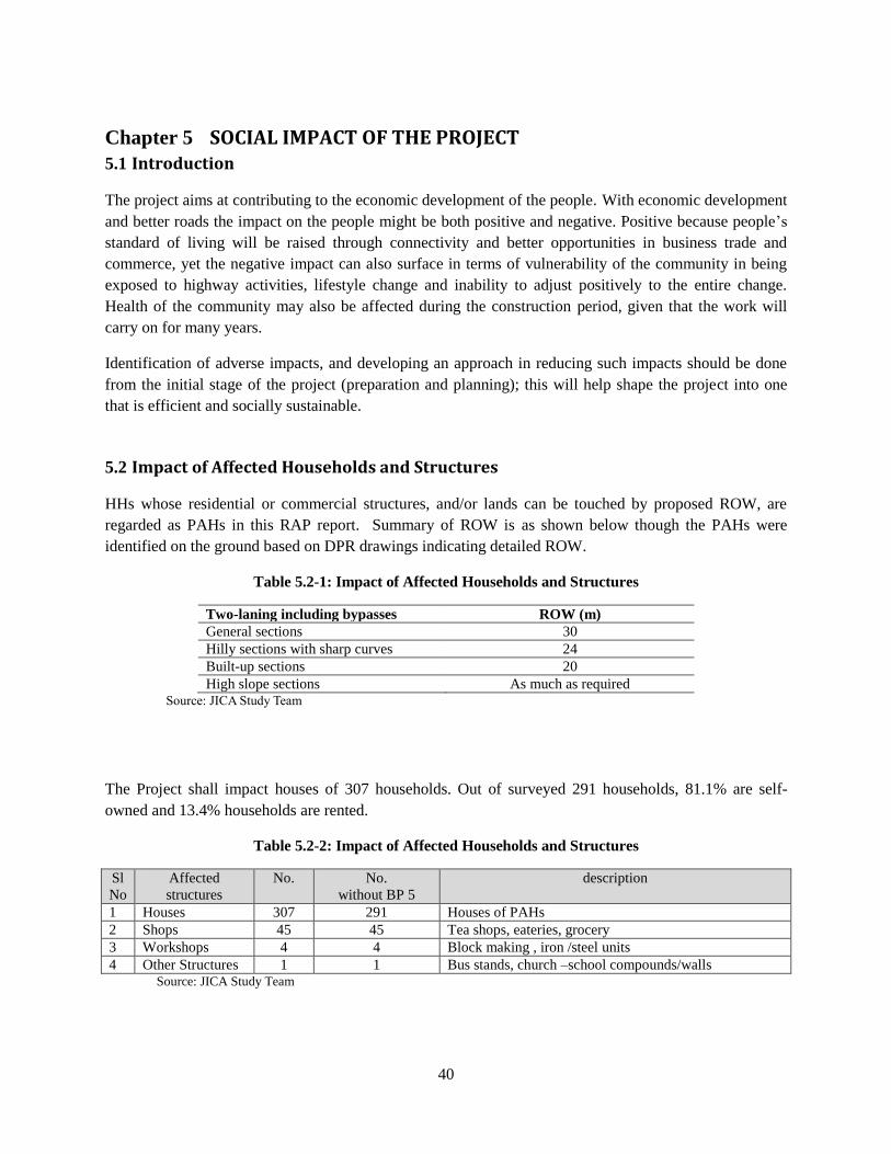
40
SOCIAL IMPACT OF THE PROJECT Chapter 5
Introduction 5.1
The project aims at contributing to the economic development of the people. With economic development
and better roads the impact on the people might be both positive and negative. Positive because people’s
standard of living will be raised through connectivity and better opportunities in business trade and
commerce, yet the negative impact can also surface in terms of vulnerability of the community in being
exposed to highway activities, lifestyle change and inability to adjust positively to the entire change.
Health of the community may also be affected during the construction period, given that the work will
carry on for many years.
Identification of adverse impacts, and developing an approach in reducing such impacts should be done
from the initial stage of the project (preparation and planning); this will help shape the project into one
that is efficient and socially sustainable.
Impact of Affected Households and Structures 5.2
HHs whose residential or commercial structures, and/or lands can be touched by proposed ROW, are
regarded as PAHs in this RAP report. Summary of ROW is as shown below though the PAHs were
identified on the ground based on DPR drawings indicating detailed ROW.
Table 5.2-1: Impact of Affected Households and Structures
Two-laning including bypasses ROW (m)
General sections 30
Hilly sections with sharp curves 24
Built-up sections 20
High slope sections As much as required Source: JICA Study Team
The Project shall impact houses of 307 households. Out of surveyed 291 households, 81.1% are self-
owned and 13.4% households are rented.
Table 5.2-2: Impact of Affected Households and Structures
Sl
No
Affected
structures
No. No.
without BP 5
description
1 Houses 307 291 Houses of PAHs
2 Shops 45 45 Tea shops, eateries, grocery
3 Workshops 4 4 Block making , iron /steel units
4 Other Structures 1 1 Bus stands, church –school compounds/walls Source: JICA Study Team
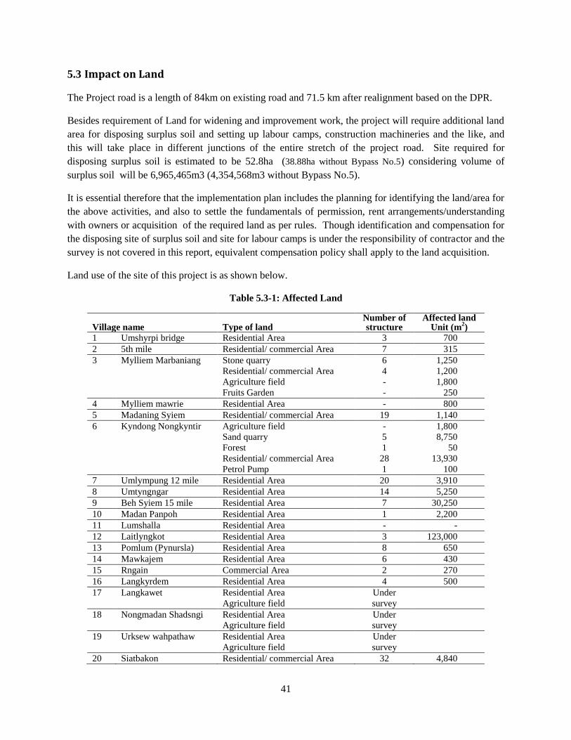
41
Impact on Land 5.3
The Project road is a length of 84km on existing road and 71.5 km after realignment based on the DPR.
Besides requirement of Land for widening and improvement work, the project will require additional land
area for disposing surplus soil and setting up labour camps, construction machineries and the like, and
this will take place in different junctions of the entire stretch of the project road. Site required for
disposing surplus soil is estimated to be 52.8ha (38.88ha without Bypass No.5) considering volume of
surplus soil will be 6,965,465m3 (4,354,568m3 without Bypass No.5).
It is essential therefore that the implementation plan includes the planning for identifying the land/area for
the above activities, and also to settle the fundamentals of permission, rent arrangements/understanding
with owners or acquisition of the required land as per rules. Though identification and compensation for
the disposing site of surplus soil and site for labour camps is under the responsibility of contractor and the
survey is not covered in this report, equivalent compensation policy shall apply to the land acquisition.
Land use of the site of this project is as shown below.
Table 5.3-1: Affected Land
Village name Type of land Number of structure
Affected land Unit (m
2)
1 Umshyrpi bridge Residential Area 3 700
2 5th mile Residential/ commercial Area 7 315
3 Mylliem Marbaniang Stone quarry
Residential/ commercial Area
Agriculture field
Fruits Garden
6
4
-
-
1,250
1,200
1,800
250
4 Mylliem mawrie Residential Area - 800
5 Madaning Syiem Residential/ commercial Area 19 1,140
6 Kyndong Nongkyntir Agriculture field
Sand quarry
Forest
Residential/ commercial Area
Petrol Pump
-
5
1
28
1
1,800
8,750
50
13,930
100
7 Umlympung 12 mile Residential Area 20 3,910
8 Umtyngngar Residential Area 14 5,250
9 Beh Syiem 15 mile Residential Area 7 30,250
10 Madan Panpoh Residential Area 1 2,200
11 Lumshalla Residential Area - -
12 Laitlyngkot Residential Area 3 123,000
13 Pomlum (Pynursla) Residential Area 8 650
14 Mawkajem Residential Area 6 430
15 Rngain Commercial Area 2 270
16 Langkyrdem Residential Area 4 500
17 Langkawet Residential Area
Agriculture field
Under
survey
18 Nongmadan Shadsngi Residential Area
Agriculture field
Under
survey
19 Urksew wahpathaw Residential Area
Agriculture field
Under
survey
20 Siatbakon Residential/ commercial Area 32 4,840
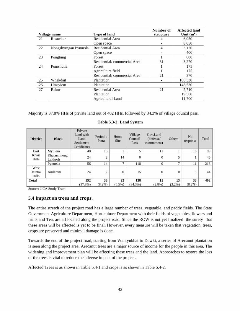
42
Village name Type of land Number of structure
Affected land Unit (m
2)
21 Risawkur Residential Area
Open space
4
-
6,050
8,650
22 Nongshyrngan Pynursla Residential Area
Open space
4
-
3,120
400
23 Pongtung Forest
Residential/ commercial Area
1
31
600
3,270
24 Pomshutia Forest
Agriculture field
Residential/ commercial Area
1
1
21
175
175
370
25 Whakdait Plantation - 180,330
26 Umsyiem Plantation - 148,530
27 Bakur Residential Area
Plantation
Agricultural Land
21 5,710
19,500
11,700
Majority is 37.8% HHs of private land out of 402 HHs, followed by 34.3% of village council pass.
Table 5.3-2: Land System
District Block
Private
Land with
Land
Settlement
Certificates
Periodic
Patta
Home
Site
Village
Council
Pass
Gov.Land
(defense/
cantonment)
Others No
response Total
East
Khasi
Hills
Mylliem 48 15 1 5 11 1 18 99
Khatarshnong
Laitkroh 24 2 14 0 0 5 1 46
Pynursla 56 14 7 118 0 7 11 213
West
Jaintia
Hills Amlarem 24 2 0 15 0 0 3 44
Total 152 33 22 138 11 13 33 402
(37.8%) (8.2%) (5.5%) (34.3%) (2.8%) (3.2%) (8.2%)
Source: JICA Study Team
Impact on trees and crops. 5.4
The entire stretch of the project road has a large number of trees, vegetable, and paddy fields. The State
Government Agriculture Department, Horticulture Department with their fields of vegetables, flowers and
fruits and Tea, are all located along the project road. Since the ROW is not yet finalized the surety that
these areas will be affected is yet to be final. However, every measure will be taken that vegetation, trees,
crops are preserved and minimal damage is done.
Towards the end of the project road, starting from Wahlynkhat to Dawki, a series of Arecanut plantation
is seen along the project area. Arecanut trees are a major source of income for the people in this area. The
widening and improvement plan will be affecting these trees and the land. Approaches to restore the loss
of the trees is vital to reduce the adverse impact of the project.
Affected Trees is as shown in Table 5.4-1 and crops is as shown in Table 5.4-2.
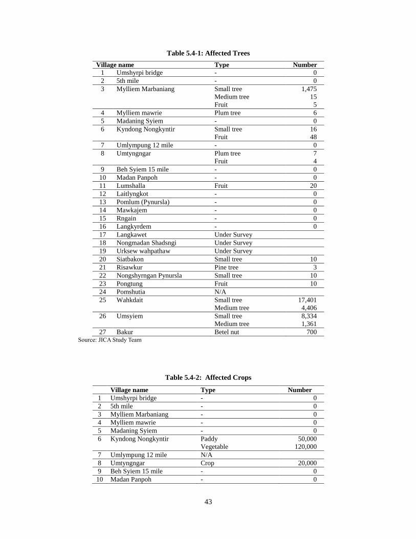
43
Table 5.4-1: Affected Trees
Village name Type Number
1 Umshyrpi bridge - 0
2 5th mile - 0
3 Mylliem Marbaniang Small tree
Medium tree
Fruit
1,475
15
5
4 Mylliem mawrie Plum tree 6
5 Madaning Syiem - 0
6 Kyndong Nongkyntir Small tree
Fruit
16
48
7 Umlympung 12 mile - 0
8 Umtyngngar Plum tree
Fruit
7
4
9 Beh Syiem 15 mile - 0
10 Madan Panpoh - 0
11 Lumshalla Fruit 20
12 Laitlyngkot - 0
13 Pomlum (Pynursla) - 0
14 Mawkajem - 0
15 Rngain - 0
16 Langkyrdem - 0
17 Langkawet Under Survey
18 Nongmadan Shadsngi Under Survey
19 Urksew wahpathaw Under Survey
20 Siatbakon Small tree 10
21 Risawkur Pine tree 3
22 Nongshyrngan Pynursla Small tree 10
23 Pongtung Fruit 10
24 Pomshutia N/A
25 Wahkdait Small tree
Medium tree
17,401
4,406
26 Umsyiem Small tree
Medium tree
8,334
1,361
27 Bakur Betel nut 700 Source: JICA Study Team
Table 5.4-2: Affected Crops
Village name Type Number
1 Umshyrpi bridge - 0
2 5th mile - 0
3 Mylliem Marbaniang - 0
4 Mylliem mawrie - 0
5 Madaning Syiem - 0
6 Kyndong Nongkyntir Paddy
Vegetable
50,000
120,000
7 Umlympung 12 mile N/A
8 Umtyngngar Crop 20,000
9 Beh Syiem 15 mile - 0
10 Madan Panpoh - 0
44
Village name Type Number
11 Lumshalla Crop 20,000
12 Laitlyngkot - 0
13 Pomlum (Pynursla) - 0
14 Mawkajem - 0
15 Rngain - 0
16 Langkyrdem - 0
17 Langkawet Under Survey
18 Nongmadan Shadsngi Under Survey
19 Urksew wahpathaw Under Survey
20 Siatbakon Pumpkin
Vegetable
20,000
120,000
21 Risawkur Crop 108,000
22 Nongshyrngan Pynursla Crop 20,000
23 Pongtung Crop 120,000
24 Pomshutia Crop -
25 Wahkdait Betel nut 6,370,000
26 Umsyiem Betel nut 4,050,000
27 Bakur Betel nut 1,982,000 Source: JICA Study Team
Social Impacts 5.5
5.5.1 Involuntary Resettlement
As per the preliminary ROW design, the project will affect structures of 313 households (307 with houses,
45 with shops, 4 with workshops and 1 with other structures, where some households are overlapped).
The public structures of school and church, resort etc, shall be only partially affected in terms of land and
not in terms of building. The total number of people with their structures affected is approximately 1,500
though some of the households will not be subject to eternal resettlement.
5.5.2 Land Use
The project will lead to significant-scale change in land use especially on bypass sections. Moreover,
development of resettlement site to accommodate relocated households and construction of spoil bank is
likely to cause changes in land use pattern, potentially affecting existing agricultural and plantation
activities.
For sections where NH40 passes through community forest*, jhum area and plantation, engineering work
should be scheduled in a way that minimizes disruption of access to such areas by local people. At the
same time, proper management of effluent and soil erosion shall be carried out to avoid negative impact
on such resources.
*“Community forest” means the forest which belongs to single village/council or several group of
villages/councils and can be categorized into three types; a) village forest, b) protected forest or “Adong”,
the forest to be more protected than usual village forest and c) sacred forest, the forest protected based
on peoples’ belief. Sacred forest would not be affected by this Project as described in 5.5.10.
45
5.5.3 Local Economy and Livelihood.
One of the major outcome from the project will be the increased business ventures and opportunities that
the area will be exposed to. In terms of tourism, social events and increased trade and commerce with
neighboring villages and the State as a whole. The people along the project road especially towards the
end, are very enterprising and it is expected that the project will be taken advantage of very positively.
While the project overall will have significant positive impacts on the local and regional economy, the
better transport network may put some groups at risk at least in the short and medium-term.
5.5.4 General, Regional/City Plans
The project will create new opportunities for village and district-level development planning. In particular,
the construction of spoil bank will create large area of flat land where such surface is a scarce commodity.
The development of spoil bank, therefore, should be coordinated with the village/district’s development
plan so that the land will benefit the community. Similarly, development of resettlement site should be
well coordinated with village development plan to ensure proper supply of basic utilities and integration
of new sites with the existing village area.
5.5.5 Social Institutions and local decision making institutions
Meghalaya is a state predominantly inhabited by the Scheduled Tribe. The traditional leaders/Headmen,
the Durbar Shnong and chieftains, must be involved in decision making process of the project form the
Planning stage. Their support and influence can help make the project be executed smoothly with reduced
impediments. The activities of RAP and R&R should be built on existing social institutions; the local
people are the best guide and have the expertise to guide the project based on their traditions and cultures.
To minimize potential disturbance and avoid the risk of conflicts, however, the resettlement will be
planned within the village where relocation takes place.
5.5.6 Social infrastructure and services
The Shillong-Dawki road is the connecting road not only to the people along the area, but is also the
connecting road that is being used every day by people from Shillong who attend work/Office in various
blocks and sub divisions. The road also serves as the connecting link for school and college going
children in the periphery of the Shillong (BP 1 and 2) who attend school in the main part of Shillong. The
construction period will affect the aforementioned activities greatly; hence preparations must be made
before implementation period to minimize the adverse effect. Discussions and assistance can be taken
with District Authorities and link with the traffic police. Any construction activity that may require road
blockade, the community must be made aware at least 24 hours in advance.
46
Noise pollution will be at the highest especially for those who reside in the junctions where all the
machinery are kept. Noise Guards should be erected to minimize sound and also to reduce air pollution in
the homes of thelocal residents.
5.5.7 Unequal Distribution of Benefit and Damage and Local Conflicts of Interest
Roadside location offers critical advantages for local businesses (tea stalls, restaurant, petty shops).
Resettlement from roadside to inner part of the village may significantly undermine the viability of these
businesses, and therefore, business owners to be affected may be worse off compared with farmers to be
relocated. Likewise, allocation of plot in resettlement site may become a source of conflicts among
affected households who wish to be relocated to more advantageous plots. Sound arbitration and conflict
resolution mechanism by local leaders should be in place for smooth implementation of RAP and R&R
activity.
5.5.8 Water Usage, Water Rights, and Communal Rights
The Khasi tribal community which inhabit the major segement of NH 40 from Shillong to Dawki falling
within East Khasi Hills District and in certain segments of NH 40 falling within West Jaintia Hills District,
particularly in proposed Bypass 6&7, are inhabited by the Pnars or Jaintia tribes. Both the communities
have maintained a close symbiotic relationship with the environment since time immemorial and whose
ethno-cultural traits have been greatly influenced by the natural surroundings. Like any other tribal group,
Khasis and Jaintias have a very close affinity to nature. Forest which is an important component of nature
is intricately linked to the daily life of both the tribes.
Water sources, which are mostly located within forest and vegetation, since the tree and all varieties of
forest cover act as catchment for recharging the aquifers and replenishing ground water level as sources of
water supply to water sources including natural springs and small rivulets, traditional systems of
conserving and sustaining all such sources have been practised for generations by both the tribes. This
tradition continues even today.
Communal Rights: Over 93% of forest area within Meghalaya fall under the jurisdiction of the
Autonomous District Councils and governed by The United Khasi-Jaintia Hills Autonomous
District(Management and Control of Forests)Act, 1958.
In this act too as per provision Section 3 – Classification of forest (b) (iii) there is a specific
categorization/type – Law –adong and Law-shnong which defines : These are village forests hitherto
reserved by the villagers themselves for conserving water, etc for the use of the villages and managed by
the Sirdars or headmen with the help of village durbar.
Further under category Green Block – b(v) – These are forests belonging to an individual family or clan
or just clans and raj lands declared as Green Block by Government for aesthetic beauty and water supply
of the town of Shillong nd its suburbs and also forests that may be so declared by rules under this Act.
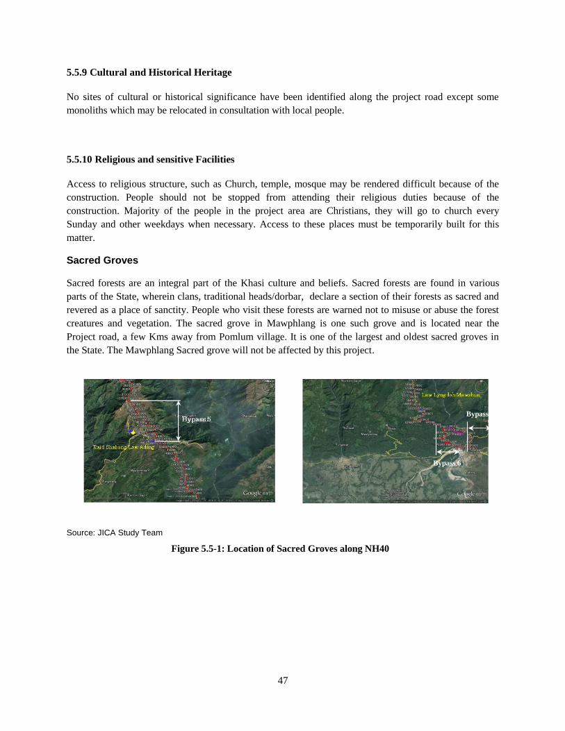
47
5.5.9 Cultural and Historical Heritage
No sites of cultural or historical significance have been identified along the project road except some
monoliths which may be relocated in consultation with local people.
5.5.10 Religious and sensitive Facilities
Access to religious structure, such as Church, temple, mosque may be rendered difficult because of the
construction. People should not be stopped from attending their religious duties because of the
construction. Majority of the people in the project area are Christians, they will go to church every
Sunday and other weekdays when necessary. Access to these places must be temporarily built for this
matter.
Sacred Groves
Sacred forests are an integral part of the Khasi culture and beliefs. Sacred forests are found in various
parts of the State, wherein clans, traditional heads/dorbar, declare a section of their forests as sacred and
revered as a place of sanctity. People who visit these forests are warned not to misuse or abuse the forest
creatures and vegetation. The sacred grove in Mawphlang is one such grove and is located near the
Project road, a few Kms away from Pomlum village. It is one of the largest and oldest sacred groves in
the State. The Mawphlang Sacred grove will not be affected by this project.
Source: JICA Study Team
Figure 5.5-1: Location of Sacred Groves along NH40
Bypass 7
Bypass 6
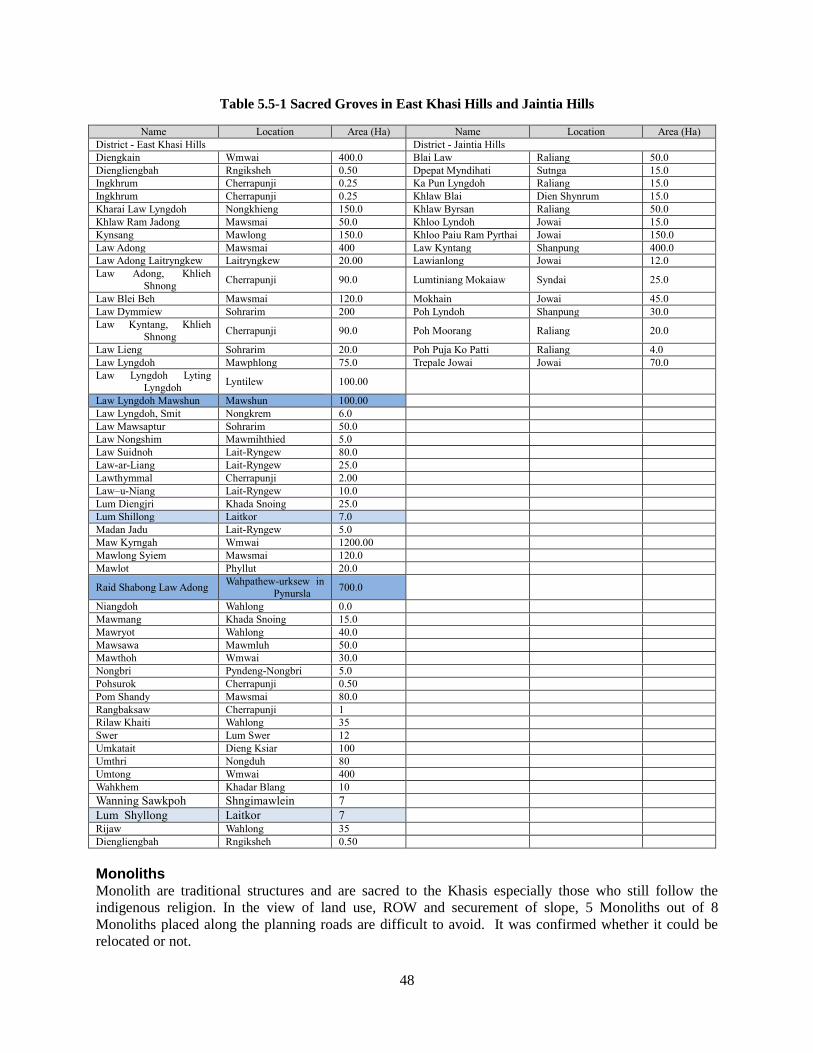
48
Table 5.5-1 Sacred Groves in East Khasi Hills and Jaintia Hills
Name Location Area (Ha) Name Location Area (Ha)
District - East Khasi Hills District - Jaintia Hills
Diengkain Wmwai 400.0 Blai Law Raliang 50.0
Diengliengbah Rngiksheh 0.50 Dpepat Myndihati Sutnga 15.0
Ingkhrum Cherrapunji 0.25 Ka Pun Lyngdoh Raliang 15.0
Ingkhrum Cherrapunji 0.25 Khlaw Blai Dien Shynrum 15.0
Kharai Law Lyngdoh Nongkhieng 150.0 Khlaw Byrsan Raliang 50.0
Khlaw Ram Jadong Mawsmai 50.0 Khloo Lyndoh Jowai 15.0
Kynsang Mawlong 150.0 Khloo Paiu Ram Pyrthai Jowai 150.0
Law Adong Mawsmai 400 Law Kyntang Shanpung 400.0
Law Adong Laitryngkew Laitryngkew 20.00 Lawianlong Jowai 12.0
Law Adong, Khlieh
Shnong Cherrapunji 90.0 Lumtiniang Mokaiaw Syndai 25.0
Law Blei Beh Mawsmai 120.0 Mokhain Jowai 45.0
Law Dymmiew Sohrarim 200 Poh Lyndoh Shanpung 30.0
Law Kyntang, Khlieh
Shnong Cherrapunji 90.0 Poh Moorang Raliang 20.0
Law Lieng Sohrarim 20.0 Poh Puja Ko Patti Raliang 4.0
Law Lyngdoh Mawphlong 75.0 Trepale Jowai Jowai 70.0
Law Lyngdoh Lyting
Lyngdoh Lyntilew 100.00
Law Lyngdoh Mawshun Mawshun 100.00
Law Lyngdoh, Smit Nongkrem 6.0
Law Mawsaptur Sohrarim 50.0
Law Nongshim Mawmihthied 5.0
Law Suidnoh Lait-Ryngew 80.0
Law-ar-Liang Lait-Ryngew 25.0
Lawthymmal Cherrapunji 2.00
Law–u-Niang Lait-Ryngew 10.0
Lum Diengjri Khada Snoing 25.0
Lum Shillong Laitkor 7.0
Madan Jadu Lait-Ryngew 5.0
Maw Kyrngah Wmwai 1200.00
Mawlong Syiem Mawsmai 120.0
Mawlot Phyllut 20.0
Raid Shabong Law Adong Wahpathew-urksew in
Pynursla 700.0
Niangdoh Wahlong 0.0
Mawmang Khada Snoing 15.0
Mawryot Wahlong 40.0
Mawsawa Mawmluh 50.0
Mawthoh Wmwai 30.0
Nongbri Pyndeng-Nongbri 5.0
Pohsurok Cherrapunji 0.50
Pom Shandy Mawsmai 80.0
Rangbaksaw Cherrapunji 1
Rilaw Khaiti Wahlong 35
Swer Lum Swer 12
Umkatait Dieng Ksiar 100
Umthri Nongduh 80
Umtong Wmwai 400
Wahkhem Khadar Blang 10
Wanning Sawkpoh Shngimawlein 7
Lum Shyllong Laitkor 7
Rijaw Wahlong 35
Diengliengbah Rngiksheh 0.50
Monoliths Monolith are traditional structures and are sacred to the Khasis especially those who still follow the
indigenous religion. In the view of land use, ROW and securement of slope, 5 Monoliths out of 8
Monoliths placed along the planning roads are difficult to avoid. It was confirmed whether it could be
relocated or not.
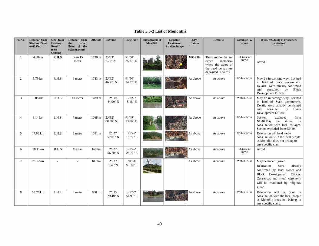
49
Table 5.5-2 List of Monoliths
Sl. No. Distance from
Starting Point
(0.00 Km)
Side from
Existing
Road
from
Shillong
Distance from
the Center
Point of the
existing Road
Altitude Latitude Longitude Photographs of
Monolith
Monolith
location on
Satellite Image
GPS
Datum
Remarks within ROW
or not
If yes, feasibility of relocation/
protection
1 4.88km R.H.S 14 to 15
meter 1739 m 25˚33'
6.27" N
91˚50'
35.87" E
WGS 84 These monoliths are
either memorial
where the ashes of
the dead person are deposited in cairns.
Outside of
ROW Avoid
2 5.79 km R.H.S 6 meter 1783 m 25˚32'
46.72" N
91˚50'
14.87" E
As above As above Within ROW May be in carriage way. Located
in land of State government.
Details were already confirmed and consulted by Block
Development Officer.
3 6.06 km R.H.S 10 meter 1789 m 25˚32'
44.99" N
91˚50'
5.18" E
As above As above Within ROW May be in carriage way. Located
in land of State government.
Details were already confirmed and consulted by Block
Development Officer
4 8.14 km L.H.S 7 meter 1768 m 25˚32'
00.00" N
91˚49'
13.80" E
As above As above Within ROW Section excluded from
NH40.May be shifted in
consultation with local villages.
Section excluded from NH40.
5 17.88 km R.H.S 8 meter 1691 m 25˚27'
57.01" N
91˚49'
18.70" E
As above As above Within ROW Relocation will be done in
consultation with the local people as Monolith does not belong to
any specific clan.
6 18.11km R.H.S Median 1687m 25˚27'
56.70" N
91˚49'
25.70" E
As above As above Outside of
ROW Avoid
7 21.52km - - 1839m 25˚27'
0.40"N
91˚50
'45.68"E
As above As above Within ROW May be under flyover.
Relocation were already
confirmed by land owner and
Block Development Officer.
Consensus and ritual ceremony
will be examined by religious
group.
8 53.75 km L.H.S 8 meter 830 m 25˚15'
29.48" N
91˚56'
54.93" E
As above As above Within ROW Relocation will be done in
consultation with the local people
as Monolith does not belong to
any specific clans.
48
5.5.11 Poor people
People from BPL or poor people in general must be considered when making R&R activity and R AP. It is
noted that poor people are less exposed big development project and hence may feel intimidated and unable
to voice concern, grievances and suggestions. Measures can be taken to ensure the poor are included and their
grievances heard and redressed.
5.5.12 Indigenous people and ethnic minorities
Meghalaya is a State predominantly inhabited by the Tribal People. Majority of Meghalayans are Scheduled
Tribe as per Constitution of India. The project area also have majority of the PAPs as Khasi, with few Garo
and Bengali. Exclusion of Scheduled Tribe in this project does not arise. However other elements of
indigenous people preservation need to be held, such as inclusion in decision making process, and grievance
redress.
49
STAKEHOLDER CONSULTATION Chapter 6
Overview 6.1
The involvement of the communities in the project area is significant for the project implementation in terms
of transparent and democratic decision-making. People’s participation from the planning stage is hence a vital
ingredient for a project that is efficient and effective. This project has ensured that communities along the
project area are involved from the beginning, stakeholders meeting were held at key venues of the project
road.
The purpose of the stakeholder consultation was to inform people about the project, listen and consider their
issues and suggestions. Potential project affected persons, local community, relevant departments attended
these consultations.
Method of Stakeholders consultation 6.2
The people were informed through phone and official letters from a local NGO, the North East Educational
and Development Society (NEEDS). All participants were given a platform to raise questions and give
suggestions. The consultations used the local language which is Khasi, the brochure which contains
information about the project was translated and presented in Khasi
The key subjects discussed in these consultations include:
Information about the project – including the socio economic survey.
Possibility of resettlement, resettlement policy-assistance, compensation, schedule and
grievance mechanism.
While most stakeholders have no objections to the project implementation and the survey, there were a few
who raised objections and refused to cooperate. Towards the end of the survey, one village, village
Siatbakhon with over 60 affected households, decided to cooperate and allowed the survey to take place, this
was an impediment to the flow of the survey, wherein analysis and tabulations had to be postponed till the
survey was completed in this village.
1st Round consultation with Communities: 6.3
The North East Educational and Development Society (NEEDS) visited the villages under the project to
inform about the project and seek support and consent for the survey. The details of all the meetings are
summarized in Table 6.3-1.
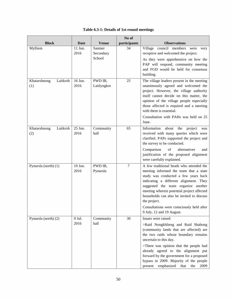
50
Table 6.3-1: Details of 1st-round meetings
Block Date Venue
No of
participants Observations
Mylliem 11 Jun.
2016
Sanmer
Secondary
School
34 Village council members were very
receptive and welcomed the project.
As they were apprehensive on how the
PAP will respond, community meeting
and FGD would be held for consensus
building.
Khatarshnong Laitkroh
(1)
16 Jun.
2016
PWD IB,
Laitlyngkot
25 The village leaders present in the meeting
unanimously agreed and welcomed the
project. However, the village authority
itself cannot decide on this matter, the
opinion of the village people especially
those affected is required and a meeting
with them is essential.
Consultation with PAHs was held on 25
June.
Khatarshnong Laitkroh
(2)
25 Jun.
2016
Community
hall
65 Information about the project was
received with many queries which were
clarified. PAPs supported the project and
the survey to be conducted.
Comparison of alternatives and
justification of the proposed alignment
were carefully explained.
Pynursla (north) (1) 10 Jun.
2016
PWD IB,
Pynursla
7 A few traditional heads who attended the
meeting informed the team that a state
study was conducted a few years back
indicating a different alignment. They
suggested the team organize another
meeting wherein potential project affected
households can also be invited to discuss
the project.
Consultations were consciously held after
9 July, 12 and 19 August.
Pynursla (north) (2) 9 Jul.
2016
Community
hall
30 Issues were raised:
>Raid Nongkhlieng and Raid Shabong
(community lands that are affected) are
the two raids whose boundary remains
uncertain to this day.
>There was opinion that the people had
already agreed to the alignment put
forward by the government for a proposed
bypass in 2009. Majority of the people
present emphasized that the 2009
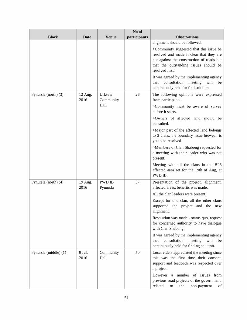
51
Block Date Venue
No of
participants Observations
alignment should be followed.
>Community suggested that this issue be
resolved and made it clear that they are
not against the construction of roads but
that the outstanding issues should be
resolved first.
It was agreed by the implementing agency
that consultation meeting will be
continuously held for find solution.
Pynursla (north) (3) 12 Aug.
2016
Urksew
Community
Hall
26 The following opinions were expressed
from participants.
>Community must be aware of survey
before it starts.
>Owners of affected land should be
consulted.
>Major part of the affected land belongs
to 2 clans, the boundary issue between is
yet to be resolved.
>Members of Clan Shabong requested for
a meeting with their leader who was not
present.
Meeting with all the clans in the BP5
affected area set for the 19th of Aug, at
PWD IB.
Pynursla (north) (4) 19 Aug.
2016
PWD IB
Pynursla
37 Presentation of the project, alignment,
affected areas, benefits was made.
All the clan leaders were present.
Except for one clan, all the other clans
supported the project and the new
alignment.
Resolution was made - status quo, request
for concerned authority to have dialogue
with Clan Shabong.
It was agreed by the implementing agency
that consultation meeting will be
continuously held for finding solution.
Pynursla (middle) (1) 9 Jul.
2016
Community
Hall
50 Local elders appreciated the meeting since
this was the first time their consent,
support and feedback was respected over
a project.
However a number of issues from
previous road projects of the government,
related to the non-payment of
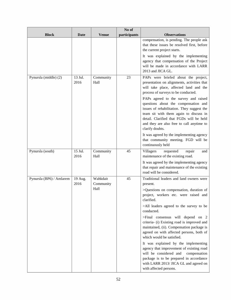
52
Block Date Venue
No of
participants Observations
compensation, is pending. The people ask
that these issues be resolved first, before
the current project starts.
It was explained by the implementing
agency that compensation of the Project
will be made in accordance with LARR
2013 and JICA GL.
Pynursla (middle) (2) 13 Jul.
2016
Community
Hall
23 PAPs were briefed about the project,
presentation on alignments, activities that
will take place, affected land and the
process of surveys to be conducted.
PAPs agreed to the survey and raised
questions about the compensation and
issues of rehabilitation. They suggest the
team sit with them again to discuss in
detail. Clarified that FGDs will be held
and they are also free to call anytime to
clarify doubts.
It was agreed by the implementing agency
that community meeting. FGD will be
continuously held
Pynursla (south) 15 Jul.
2016
Community
Hall
45 Villagers requested repair and
maintenance of the existing road.
It was agreed by the implementing agency
that repair and maintenance of the existing
road will be considered.
Pynursla (BP6) / Amlarem 19 Aug.
2016
Wahkdait
Community
Hall
45 Traditional leaders and land owners were
present.
>Questions on compensation, duration of
project, workers etc. were raised and
clarified.
>All leaders agreed to the survey to be
conducted.
>Final consensus will depend on 2
criteria- (i) Existing road is improved and
maintained, (ii). Compensation package is
agreed on with affected persons, both of
which would be satisfied.
It was explained by the implementing
agency that improvement of existing road
will be considered and compensation
package is to be prepared in accordance
with LARR 2013/ JICA GL and agreed on
with affected persons.
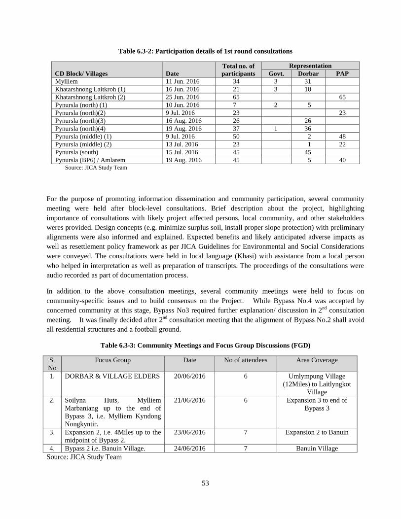
53
Table 6.3-2: Participation details of 1st round consultations
CD Block/ Villages Date
Total no. of
participants
Representation
Govt. Dorbar PAP
Mylliem 11 Jun. 2016 34 3 31
Khatarshnong Laitkroh (1) 16 Jun. 2016 21 3 18
Khatarshnong Laitkroh (2) 25 Jun. 2016 65 65
Pynursla (north) (1) 10 Jun. 2016 7 2 5
Pynursla (north)(2) 9 Jul. 2016 23 23
Pynursla (north)(3) 16 Aug. 2016 26 26
Pynursla (north)(4) 19 Aug. 2016 37 1 36
Pynursla (middle) (1) 9 Jul. 2016 50 2 48
Pynursla (middle) (2) 13 Jul. 2016 23 1 22
Pynursla (south) 15 Jul. 2016 45 45
Pynursla (BP6) / Amlarem 19 Aug. 2016 45 5 40 Source: JICA Study Team
For the purpose of promoting information dissemination and community participation, several community
meeting were held after block-level consultations. Brief description about the project, highlighting
importance of consultations with likely project affected persons, local community, and other stakeholders
weres provided. Design concepts (e.g. minimize surplus soil, install proper slope protection) with preliminary
alignments were also informed and explained. Expected benefits and likely anticipated adverse impacts as
well as resettlement policy framework as per JICA Guidelines for Environmental and Social Considerations
were conveyed. The consultations were held in local language (Khasi) with assistance from a local person
who helped in interpretation as well as preparation of transcripts. The proceedings of the consultations were
audio recorded as part of documentation process.
In addition to the above consultation meetings, several community meetings were held to focus on
community-specific issues and to build consensus on the Project. While Bypass No.4 was accepted by
concerned community at this stage, Bypass No3 required further explanation/ discussion in 2nd
consultation
meeting. It was finally decided after 2nd
consultation meeting that the alignment of Bypass No.2 shall avoid
all residential structures and a football ground.
Table 6.3-3: Community Meetings and Focus Group Discussions (FGD)
S.
No
Focus Group Date No of attendees Area Coverage
1. DORBAR & VILLAGE ELDERS 20/06/2016 6 Umlympung Village
(12Miles) to Laitlyngkot
Village
2. Soilyna Huts, Mylliem
Marbaniang up to the end of
Bypass 3, i.e. Mylliem Kyndong
Nongkyntir.
21/06/2016 6 Expansion 3 to end of
Bypass 3
3. Expansion 2, i.e. 4Miles up to the
midpoint of Bypass 2.
23/06/2016 7 Expansion 2 to Banuin
4. Bypass 2 i.e. Banuin Village. 24/06/2016 7 Banuin Village
Source: JICA Study Team
54
2nd Round Consultation with Communities 6.4
The second round consultation with communities was to share the result of the socio economic survey and to
discuss with PAPs on the comprehensive composition of resettlement and compensation.
Table 6.4-1: Details of 2nd
Round Meetings
Block Date Venue No of
parti-
cipants
Observations
Mylliem/ Khatarshnong
Laitkroh/ Pynursla/ Amlarem
5 Nov,
2016
Sanmer secondary
School
149 Concern for impact on paddy fields at
BP was presented. Explained the
impact can be minimized by using
box culvert and ensuring irrigation.
Also concern on business at detoured
villages was presented. NHIDCL
agreed that they will build temporary
structure for business within ROW of
new bypass.
Primary health center will be directed
affected at Dawki. It will be rebuilt
whose cost will be borne by NHIDCL
and old structure will be demolished
only after operation of new building.
Explained livelihood support
available for affected persons.
Pynursla/ Amlarem 12 Dec,
2016
Wahkdait
Community Hall
91 Explained existing road will be
repaired at the section of BP6&7.
Answering to question about
compensation policy, it was
explained that it will follow LARR
2013 and also JICA guideline in case
that the project is funded by JICA.
Answering to question about
dumping on roadside, it was
explained that appropriate locations
would be selected not to disturb
residents.
Answering to determination of
PAHs, it was explained that it would
be done through joint inspection by
Deputy Commissioner and
preparation of land owners.
The economic benefits to the area
was highlighted including tourism
potential with a new bridge at
Dawki.
Attendees expressed their keenness
that the project is started at the
earliest.
Source: JICA Study Team
55
Table 6.4-2: Participation details of 2nd
Round Meetings
CD Block/ Villages Date Total no of
participants
Representation
Govt Dorbar PAP
Mylliem/ Khatarshnong Laitkroh/
Pynursla/ Amlarem
2016/11/5 149 3 14 132
Pynursla/ Amlarem 2016/12/5 91 7 83
Source: JICA Study Team
Supplemental Consultation Meetings 6.5
For solving concerns regarding alignments, some re-alignment was re-examined. Accordingly, supplemental
meetings were held for Bypass No.2 and No. 5.
Table 6.5-1: Details of All Meetings
Village Date Venue No of
parti-
cipants
Observations
Mylliem/ Banium 19/5/17 Office
chamber of
the Deputy
Commission
er, East
Khasi Hills,
Shillong
10 Regarding Bypass No. 2, the realigned
route was proposed by NHIDCL/DPR
consultants slightly to Right Hand Side for
minimizing impact on HHs and lands.
The matter of BP-II has been elaborated to
the DC/EE PWD NH/Local
Headman/Local Villagers and it has been
decided to safeguard the proposed football
ground. Accordingly the consultant has
been asked to shift the alignment slightly
towards right of the proposed alignment.
The consultant has agreed to modify the
alignment. Hence the issue of Bypass No.2
is resolved.
Pynursla/ Wahlyngkhat,
Uksew
19/5/17 Office
chamber of
the Deputy
Commission
er, East
Khasi Hills,
Shillong
17 Regarding Bypass No. 5, it has been
proposed by DC, East Khasi Hills to go
with existing alignment. since the
Sordor/Headmen are not agreed to go with
proposed alignment of Bypass No. 5.
The issue of Bypass No.5 needs further
examination.
Source: JICA Study Team
Table 6.5-2: Participation Details of Supplemental Consultation Meetings
CD Block/ Villages Date Total no of
participants
Representation
Govt Dorbar PAP
Mylliem/ Banium 19/5/2017 10 4 1 5
Pynursla/ Wahlyngkhat, Uksew 19/5/2017 17 4 3 10
56
Information Disclosure 6.6
The Socio Economic report will be posted in the websites of the NHIDCL and JICA. The same will be shared
with the community, especially the local leaders/traditional heads and the PAHs.
Umjapung 12
th mile- PAPa Laitlyngkot- Traditional leaders
Urksew - Traditional leaders 12
th mile PAPs and Traditional leaders
Consultation with Traditional Heads of clans in Pynursla
Figure 6.6-1: 1st Stakeholders/community Meetings
57
2nd
Stakeholder Meetings at Sanmer secondary School
2nd
Stakeholder Meetings at Wahkdait
Figure 6.6-2: 2nd Stakeholders/community Meetings
58
RESETTLEMENT POLICY Chapter 7
Objective of Resettlement Policy Framework 7.1
The resettlement policy of the project is prepared according to the principles of the R& R policy of the GOI a
in line with the requirements of JICA guidelines and policies; the ADB safeguard policy 2009 is also referred
to, based on the experience of previous RAP prepared by ADB in the State. Meghalaya follows a strict Land
system management through its State Act- Meghalaya transfer of Land Regulation Act 1971, which was
amended in 2010 ( Meghalaya Transfer of Land Regulation Act 2010) and received assent by the President in
2012. The act however does not have specific rules on land acquisition which needed when big development
projects are implemented.
In appreciating this verity, the policy framework for this project can realize the following:
The resettlement policy of similar projects in Meghalaya – (a).Road upgradation (Shillong-
Nongstoin- Tura) Project, 2 laning of Shillong Nongstoin NG 44 and Nongstoin-Tura road under
phase A of SARDP-NE. (b). Jorabad-Shillong NH 40 road project (4 laning of Jorabad Shillong
section) under the SARDP-NE.
Strengthen the capacity of the various institutions relevant to the project especially those
implementing the project from the Government side, in terms of comprehension and practical
execution of RAP and livelihood restoration.
Collate all the successful RAPs of similar projects in the State and build upon the State previous
experiences and learnings.
Establish a grievance redressal Mechanism that will ensure that the issues of project affected
people are heard and addressed, resulting in a fair and justified RAP.
The policy framework stresses on the following key values:
The affected Community is involved from the initial phase; through community and stakeholder
meetings, FGDs, that informs the people about the project and their views are noted. Information
about compensation, land acquisition, loss of livelihood is shared in the preparation stage.
The consent of the community, especially the PAPs is compulsory for initiation of the survey and the
project at large.
Inclusion is accentuate with the involvement of vulnerable and marginalized groups such as women,
minority groups and others wherever present.
When displacement in inevitable, people affected will be assisted in measures that will better their
current status of living without having to bear any cost. The socio economic conditions of the PAPs
must improve after project implementation.
Involuntary settlement should be avoided or minimized as far as possible. Caution to affect any
Religious and traditional structures , habitations, sanctuaries will be taken, through alternate routes,
if not possible, all customary measures adopted by the community to remove such structures will be
respected and assisted at the relevant cost.
Relocation site could be found, with assistance from community if available, basically within the
community where the household belongs. If not available, assistance shall be made through District
Collector under the responsibility of Implementation Agency.
Payment of compensation and assistance to PAPs will be ensured before the civil work of the project
starts.
59
All land acquisition will be carried out after issuance of notifications for harvesting of crops.
Child labour will not be involved .
Though identification, compensation and acquisition for the disposing site of surplus soil and
site for labour camps is under the responsibility of contractor and the survey is not covered in
this report, equivalent compensation policy shall apply to the land acquisition.
Women workers will be provided with gender friendly facilities on project site, and be paid
equal wages for equal volume of work.
Health Education focusing on HIV, STIs at the project sites, labour camps, will be compulsory
when the civil work starts.
Entitlement Matrix: 7.2
The Entitlement Matrix has been developed in accordance with the principles adopted and analysis of initial
identification of project impacts. The Entitlement Matrix recognizes and lists various types of losses
associated with the project and provides the basic tools and guidelines for preparation of compensation and
resettlement packages.
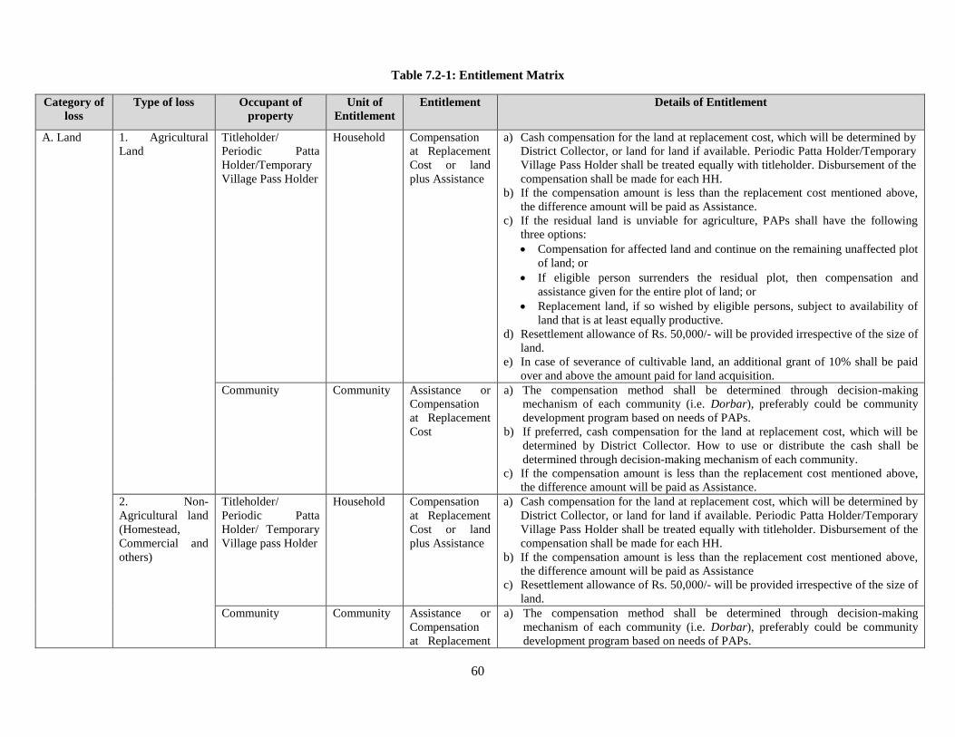
60
Table 7.2-1: Entitlement Matrix
Category of
loss
Type of loss Occupant of
property
Unit of
Entitlement
Entitlement Details of Entitlement
A. Land 1. Agricultural
Land
Titleholder/
Periodic Patta
Holder/Temporary
Village Pass Holder
Household Compensation
at Replacement
Cost or land
plus Assistance
a) Cash compensation for the land at replacement cost, which will be determined by
District Collector, or land for land if available. Periodic Patta Holder/Temporary
Village Pass Holder shall be treated equally with titleholder. Disbursement of the
compensation shall be made for each HH.
b) If the compensation amount is less than the replacement cost mentioned above,
the difference amount will be paid as Assistance.
c) If the residual land is unviable for agriculture, PAPs shall have the following
three options:
Compensation for affected land and continue on the remaining unaffected plot
of land; or
If eligible person surrenders the residual plot, then compensation and
assistance given for the entire plot of land; or
Replacement land, if so wished by eligible persons, subject to availability of
land that is at least equally productive.
d) Resettlement allowance of Rs. 50,000/- will be provided irrespective of the size of
land.
e) In case of severance of cultivable land, an additional grant of 10% shall be paid
over and above the amount paid for land acquisition.
Community Community Assistance or
Compensation
at Replacement
Cost
a) The compensation method shall be determined through decision-making
mechanism of each community (i.e. Dorbar), preferably could be community
development program based on needs of PAPs.
b) If preferred, cash compensation for the land at replacement cost, which will be
determined by District Collector. How to use or distribute the cash shall be
determined through decision-making mechanism of each community.
c) If the compensation amount is less than the replacement cost mentioned above,
the difference amount will be paid as Assistance.
2. Non-
Agricultural land
(Homestead,
Commercial and
others)
Titleholder/
Periodic Patta
Holder/ Temporary
Village pass Holder
Household Compensation
at Replacement
Cost or land
plus Assistance
a) Cash compensation for the land at replacement cost, which will be determined by
District Collector, or land for land if available. Periodic Patta Holder/Temporary
Village Pass Holder shall be treated equally with titleholder. Disbursement of the
compensation shall be made for each HH.
b) If the compensation amount is less than the replacement cost mentioned above,
the difference amount will be paid as Assistance
c) Resettlement allowance of Rs. 50,000/- will be provided irrespective of the size of
land.
Community Community Assistance or
Compensation
at Replacement
a) The compensation method shall be determined through decision-making
mechanism of each community (i.e. Dorbar), preferably could be community
development program based on needs of PAPs.
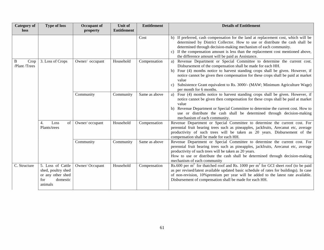
61
Category of
loss
Type of loss Occupant of
property
Unit of
Entitlement
Entitlement Details of Entitlement
Cost b) If preferred, cash compensation for the land at replacement cost, which will be
determined by District Collector. How to use or distribute the cash shall be
determined through decision-making mechanism of each community.
c) If the compensation amount is less than the replacement cost mentioned above,
the difference amount will be paid as Assistance.
B Crop
/Plant /Trees
3. Loss of Crops Owner/ occupant Household Compensation a) Revenue Department or Special Committee to determine the current cost.
Disbursement of the compensation shall be made for each HH.
b) Four (4) months notice to harvest standing crops shall be given. However, if
notice cannot be given then compensation for these crops shall be paid at market
value
c) Subsistence Grant equivalent to Rs. 3000/- (MAW; Minimum Agriculture Wage)
per month for 6 months.
Community Community Same as above a) Four (4) months notice to harvest standing crops shall be given. However, if
notice cannot be given then compensation for these crops shall be paid at market
value
b) Revenue Department or Special Committee to determine the current cost. How to
use or distribute the cash shall be determined through decision-making
mechanism of each community.
4. Loss of
Plants/trees
Owner/ occupant Household Compensation Revenue Department or Special Committee to determine the current cost. For
perennial fruit bearing trees such as pineapples, jackfruits, Arecanut etc, average
productivity of such trees will be taken as 20 years. Disbursement of the
compensation shall be made for each HH.
Community Community Same as above Revenue Department or Special Committee to determine the current cost. For
perennial fruit bearing trees such as pineapples, jackfruits, Arecanut etc, average
productivity of such trees will be taken as 20 years.
How to use or distribute the cash shall be determined through decision-making
mechanism of each community
C. Structure 5. Loss of Cattle
shed, poultry shed
or any other shed
for domestic
animals
Owner/ Occupant Household Compensation Rs.600 per m2
for thatched roof and Rs. 1000 per m2 for GCI sheet roof (to be paid
as per revised/latest available updated basic schedule of rates for buildings). In case
of non-revision, 10%premium per year will be added to the latest rate available.
Disbursement of compensation shall be made for each HH.
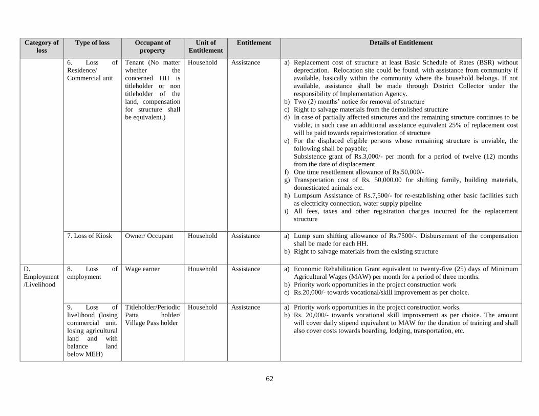
62
Category of
loss
Type of loss Occupant of
property
Unit of
Entitlement
Entitlement Details of Entitlement
6. Loss of
Residence/
Commercial unit
Tenant (No matter
whether the
concerned HH is
titleholder or non
titleholder of the
land, compensation
for structure shall
be equivalent.)
Household Assistance a) Replacement cost of structure at least Basic Schedule of Rates (BSR) without
depreciation. Relocation site could be found, with assistance from community if
available, basically within the community where the household belongs. If not
available, assistance shall be made through District Collector under the
responsibility of Implementation Agency.
b) Two (2) months’ notice for removal of structure
c) Right to salvage materials from the demolished structure
d) In case of partially affected structures and the remaining structure continues to be
viable, in such case an additional assistance equivalent 25% of replacement cost
will be paid towards repair/restoration of structure
e) For the displaced eligible persons whose remaining structure is unviable, the
following shall be payable;
Subsistence grant of Rs.3,000/- per month for a period of twelve (12) months
from the date of displacement
f) One time resettlement allowance of Rs.50,000/-
g) Transportation cost of Rs. 50,000.00 for shifting family, building materials,
domesticated animals etc.
h) Lumpsum Assistance of Rs.7,500/- for re-establishing other basic facilities such
as electricity connection, water supply pipeline
i) All fees, taxes and other registration charges incurred for the replacement
structure
7. Loss of Kiosk Owner/ Occupant Household Assistance a) Lump sum shifting allowance of Rs.7500/-. Disbursement of the compensation
shall be made for each HH.
b) Right to salvage materials from the existing structure
D.
Employment
/Livelihood
8. Loss of
employment
Wage earner Household Assistance a) Economic Rehabilitation Grant equivalent to twenty-five (25) days of Minimum
Agricultural Wages (MAW) per month for a period of three months.
b) Priority work opportunities in the project construction work
c) Rs.20,000/- towards vocational/skill improvement as per choice.
9. Loss of
livelihood (losing
commercial unit.
losing agricultural
land and with
balance land
below MEH)
Titleholder/Periodic
Patta holder/
Village Pass holder
Household Assistance a) Priority work opportunities in the project construction works.
b) Rs. 20,000/- towards vocational skill improvement as per choice. The amount
will cover daily stipend equivalent to MAW for the duration of training and shall
also cover costs towards boarding, lodging, transportation, etc.
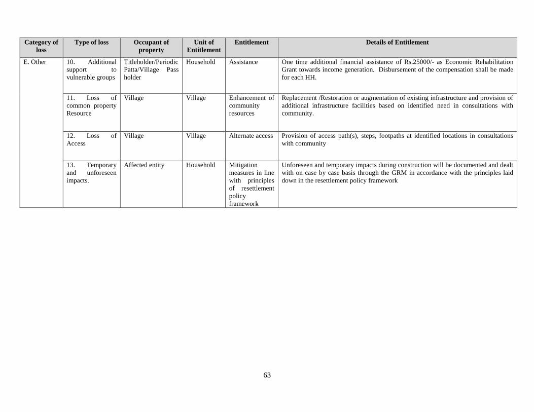
63
Category of
loss
Type of loss Occupant of
property
Unit of
Entitlement
Entitlement Details of Entitlement
E. Other 10. Additional
support to
vulnerable groups
Titleholder/Periodic
Patta/Village Pass
holder
Household Assistance One time additional financial assistance of Rs.25000/- as Economic Rehabilitation
Grant towards income generation. Disbursement of the compensation shall be made
for each HH.
11. Loss of
common property
Resource
Village Village Enhancement of
community
resources
Replacement /Restoration or augmentation of existing infrastructure and provision of
additional infrastructure facilities based on identified need in consultations with
community.
12. Loss of
Access
Village Village Alternate access Provision of access path(s), steps, footpaths at identified locations in consultations
with community
13. Temporary
and unforeseen
impacts.
Affected entity Household Mitigation
measures in line
with principles
of resettlement
policy
framework
Unforeseen and temporary impacts during construction will be documented and dealt
with on case by case basis through the GRM in accordance with the principles laid
down in the resettlement policy framework
64
Methods of Assessing Replacement Cost 7.3
The methods for assessing replacement cost is discussed as follows
The value of compensation is determined by the District Collector, considering the Country Act, policies of
JICA and the State Act where necessary and also the recent sales and acquisition in similar land and projects.
Estimating the market rate may prove difficult especially since the State is only recently experienced in land
acquisition on highways. For provisional estimate of RAP budget the official rate plus the premium for rural
land and 100% Solarium has been used as per LARR 2013, which means that the value of compensation is
four times the Official rate.
The official rate in India is usually lower than the current rate. Similarly in Meghalaya there have been
instances where PAPs were unhappy with the rate stated by the Government. The ultimate authority to decide
on the compensation lies on the DC; however the PIU has the influence to confirm whether the four times
the official rate is adequate enough. It is vital, that thorough exercises are conducted with the stakeholders
wherein the replacement cost can be agreed upon. The gap between the amount determined by DC and the
actual replacement cost will be paid as assistance.
The Basic Schedule Rate (BSR) is the tool that will determine the replacement value of
buildings/houses/immovable assets. The BSR recognized is the one applicable during the year on which the
compensation is paid, without depreciation. If the structure is considered unsafe the entire structure can be
rendered affected and compensation paid accordingly. For plants and trees the compensation will also be
paid as per the BSR of that year when compensation is paid.
Grievance Redress Mechanism 7.4
In order to provide an accessible mechanism to the affected people, community and any stakeholder(s) to
raise their issues and grievances as well as concerns, a GRM will be established within the project ambit. The
fundamental objectives of GRM are to resolve any land acquisition disputes in consultation with the
aggrieved party to facilitate smooth implementation of the project. Another important objective is to
democratize the development process at the local level and to establish accountability to the stakeholders.
The scope of GRM :
Consider only those grievances that has linkages to or bearing on the project
Review, consider and resolve grievances related to land acquisition aspects of the project
received by the different forums devised for GRM;
Resolve grievances within a specified period set out in the document;
Arrive at decisions through consensus. Any decision made by the GRM must be within the
purview of project framework and entitlements;
Require a minimum three (3) members to form the quorum for the meeting at various levels.
The frequency of meeting may increase or decrease depending on the number grievances
received;
If needed, may undertake field visits to verify and review the issues, dispute or other
relevant matters.
The following is the structure of the GRM:
65
Village/block level- involves physical verification, certification on grievances related to
inaccurate measurements, damage to structures, crops etc during construction. The RAP
supporting NGO under the implementing agency, as the focal point of GRM, will carry out
the verification and certification. Village councils/Dorbar/headmen will also support the
implementing agency, in the presence of the aggrieved PAP.
Time taken for the above process should be for 7 – 10 days counting from the day the
grievance is received.
A District Level Committee Grievance Redress Committee (GRC) will be formed by the
project authority and will comprise of Project Director, Official from NHIDCL, PWD,
Deputy Commissioner of East Khasi Hills and West Jaintia Hills, Officer from
KHADC/JHADC and the implementing agency. PAPs should give their grievances in
writing to the GRC; the Implementing agency will guide and assist the aggrieved PAP in
his/her case. GRC will respond to the grievance in 7 days.
The GRC should meet once in 15 days or more , depending on availability of cases/ issues.
Grievances submitted to the GRC will be redressed within 30 days from the day the
grievance was received.
GRC may not deal with any matters pending in the court of law, however that does not stop
the aggrieved party to approach the Court, if he/she is not satisfied with the decision of the
GRC.
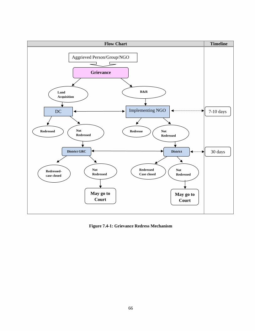
66
Flow Chart Timeline
Figure 7.4-1: Grievance Redress Mechanism
30 days
Aggrieved Person/Group/NGO
Implementing NGO
Redressed Redresse
d
May go to
Court
District GRC District
GRC
Redressed-
case closed
R&R
Grievance
DC
Not
Redressed
Redressed
Case closed
Not
Redressed
Not
Redressed
May go to
Court
7-10 days
Not
Redressed
Land
Acquisition
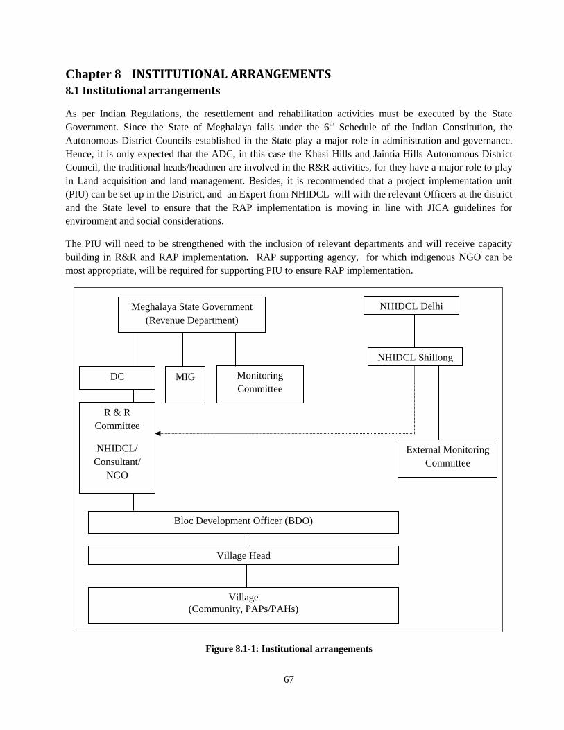
67
INSTITUTIONAL ARRANGEMENTS Chapter 8
Institutional arrangements 8.1
As per Indian Regulations, the resettlement and rehabilitation activities must be executed by the State
Government. Since the State of Meghalaya falls under the 6th Schedule of the Indian Constitution, the
Autonomous District Councils established in the State play a major role in administration and governance.
Hence, it is only expected that the ADC, in this case the Khasi Hills and Jaintia Hills Autonomous District
Council, the traditional heads/headmen are involved in the R&R activities, for they have a major role to play
in Land acquisition and land management. Besides, it is recommended that a project implementation unit
(PIU) can be set up in the District, and an Expert from NHIDCL will with the relevant Officers at the district
and the State level to ensure that the RAP implementation is moving in line with JICA guidelines for
environment and social considerations.
The PIU will need to be strengthened with the inclusion of relevant departments and will receive capacity
building in R&R and RAP implementation. RAP supporting agency, for which indigenous NGO can be
most appropriate, will be required for supporting PIU to ensure RAP implementation.
Figure 8.1-1: Institutional arrangements
Monitoring
Committee
DC MIG
Meghalaya State Government
(Revenue Department)
NHIDCL Delhi
Village Head
External Monitoring
Committee
Bloc Development Officer (BDO)
Village
(Community, PAPs/PAHs)
R & R
Committee
NHIDCL/
Consultant/
NGO
NHIDCL Shillong
68
Monitoring and Evaluation. 8.2
Monitoring and evaluation are critical for building a strong, evidence base documentation surrounding the
project; it is a tool for identifying and documenting successful programmes and approaches and tracking
progress toward common indicators across related projects. Monitoring and evaluation forms the basis of
strengthening understanding around the many multi-layered factors underlying a project. This project all the
more needs to apply strong monitoring mechanisms since it is a project which deals with infrastructure
development and involuntary settlement. RAP implementation issues can be resolved effectively when the
project has a system of check and balances thereby resulting in good management.
Evaluation allows the project to go through periodic assessments to examine impacts and sustainability; it
especially assist the project in realizing its achievement index, and review its current approach and strategies
to better the outcome of the project. Monitoring and evaluation are tools that are indispensable in the RAP
implementation for it ensures the performance and fulfillment of the project objectives.
For monitoring of livelihood rehabilitation of PAHs, data on relocation site of PAHs shall be traced using
identification number in coordination with DC. The data shall be handed over to Monitoring NGO so that
the NGO can monitor their rehabilitation progress.
8.2.1 Monitoring and Evaluation Activities:
The project can adopt two types of monitoring, the internal monitoring and the external monitoring and
evaluation.
Internal Monitoring:
It will be carried out by the PIU, PWD with assistance from the RAP implementation Agency. The PIU and
PWD will also engage and external agency (third party) to undertake monitoring at different stages of the
project, preferably biannually and evaluation at the mid- and end – term . The monitoring and evaluation will
be desk review of documentation and field based accompanied with focus group discussions with the
community, stakeholders and the implementation team.
The objectives of internal monitoring is
(i) To measure progress against the RAP implementation plan;
(ii) To Confirm if all entitlements agreed upon are delivered to PAPs;
(iii) To Identify critical issues that stall the project, or that are hurting the people, and suggest corrective
actions;
(iv) To Monitor the efficiency of the GRM; and
(v) To Appraise the satisfaction of PAPs over the activities and implantation of the project.
Key activities include:
i. Liaison with district collector to collate up-to-date information on land acquisition progress such as
agreement signing, compensation disbursement, RAP funds milestones and disbursement, land areas
under construction, land areas reinstated and the like;
ii. Review of grievance register and basic analysis of grievance types, numbers, and closures;
iii. Field visits to review corrective actions and verify complaints made.
iv. FGDs with PAPs and key informants and community stakeholders in general
v. Report preparation.
69
External Monitoring:
Independent consultants can be External Monitoring Agency. Terms of Reference of the External
Monitoring Agency is shown in Appendix 5. The fundamental objective of external monitoring is as
follows:
To assess the overall compliance of RAP in the project.
To assess the extent of the livelihood restoration effort of affected communities; whether their
quality of life is enhanced.
To authenticate the measures taken for restoration of livelihood of affected communities .
The key activities for external monitoring include:
i. Review internal monitoring procedures, documentation and reporting, to ascertain whether these
are conducted in compliance with RAP;
ii. Identify any non compliance or any unresolved/pending issue from the existing monitoring
records;
iii. Review grievance records for evidence of significant non-compliance or recurrent poor
performance in resettlement implementation;
iv. Discussion with NGO, DC, PIU and other entities involved in land acquisition, compensation
disbursement and livelihood restoration to review progress and analyze challenges;
v. Survey affected households and enterprises to gauge the extent to which project affected
people’s standards of living and livelihood have been restored or enhanced as a result of the
project;
vi. Assess the overall compliance with RAP requirements and JICA Guidelines; and
vii. Prepare a summary compliance report for NHIDCL on the progress of RAP implementation,
also stating all critical issues and the corrective actions required.
Non-Governmental Organization for Implementation of RP. 8.3
A Non-Governmental Organization can be one of the stakeholders in the entire project cycle with primary
responsibility of facilitating the implementation of RAP and help NHIDCL in mitigating the adverse impacts
of the project. This necessarily requires the selected NGO to only work with PAPs but also interface between
the local communities of the project area and the NIHDCL. Simultaneously the NGO will function as a link
between the NHIDCL, the Government, the District Administration and relevant government agencies and
Autonomous District Councils. The NGOs will be responsible for the development of a comprehensive
livelihood system and facilitate PAPs to take advantage of the options available.
The scope of work of the NGO is discussed briefly as follows:
Develop rapport with the Project authority, project staff as well as with the District
Administration/DC. This will be achieved through regular meetings and attending reviews
carried out by the Project.
Assist in ensuring compliance with the safety, health and hygiene norms; gender mainstreaming
and actions proposed for HIV/AIDS and Child labour awareness/prevention campaign, .
70
Report to the project office at district/State level on a monthly basis. The report should include
physical and financial progress both in terms of quantitative and qualitative reporting.
The report should prominently feature the problems and issues addressed and tackled with the
PAPs and the solutions found. The report should have a separate chapter covering thegender
issues, their problems and what has been done (within the framework of the RAP)to ensure their
participation in decision making as well as the options made available forthem to access
economic opportunities, marketing and credit. The report should clearlyinclude the number of
field units made by the NGO’s staff and the outcome of consultationwith the people.
The NGO shall ensure that PAF’s representatives are nominated in the Grievance Redress
Committee (GRC) and also a suitable person from its own staff to be a member of the GRC. Give
awareness on the availability of GRC and the grievance redress procedures.
Undertake a public information campaign at the commencement of the project as well as continuing
through project implementation to inform the affected communities of
i. The need for land acquisition
ii. The reasons and need for eviction of displaced households; and
iii. The likely consequences of the project on the community’s livelihood
iv. Proposed mitigation measures.
Thus the NGOs shall establish rapport with the PAPs, consult them, and provide them information about the
respective entitlements as proposed under the RAP besides assisting the project in all aspects related to
implementation.
.
71
GENDER Chapter 9
Introduction 9.1
The women in Meghalaya may fare differently from the women in other patriarchal societies, in that their
community bestows in them the custodianship of ancestral property and the lineage of the clan passing
through them. Much of the land in the project area is own by women by virtue of inheritance; however it
should also be mentioned here that the decision to sell the land will fall entirely in the decision of the Clan,
which is govern by the male elders (maternal uncle /brothers). The misconception that a Khasi woman is the
owner of land/property should be clarified with the fact that the majority in a Khasi community do not own
enough land to hand down to other daughters in the family, while the youngest is the one who inherits the
custodianship, the others are usually left without land.
The man in a matrilineal society is not insignificant at all, he is the decision maker and the provider. This
study shows that men and women make joint decisions in the immediate family matters; the women rarely
has a voice once outside the home; Traditional managing bodies like the dorbar, the village executive council,
the traditional head of the village, the clan, are all headed by men and the executive members have a majority
of men.
It is thus imperative, that development efforts or projects need to realize this vulnerable factor of women,
(even in a matrilineal society)and ensure that they are involved and consulted in the key activities of the
project.
Project potential impact: 9.2
To ensure that the community benefit fully from investments in large development projects, special
consideration should be given to any sector which promotes and/or facilitates the participation of women, the
upgrading of their skills and the development of their productive potential. A failure to consult women early
in project preparation can result in non-use of facilities and to women being by-passed in later stages.
Khasi women in the project area are mostly involved in agricultural work, house work and managing small
tea shops. It is observed that women are enterprising and hard working in bringing in income to the family
and are always doing additional work for extra wages.
The positive impact the project will have on women is the broadening of business activities in trade and
commerce, women and men in majority of the affected areas are interested and adept to managing their own
business even if it’s a small one. However there is inevitability of negative impacts, in that the relocation may
affect the women social relationships, adjustments in running a household in a different setting with lesser
earnings, reduction in land and assets. All this can result in the women opting for involuntary work to
supplement income, which could lead to vulnerabilities that may affect her social, economic, physical and
emotional health.
The RAP of the project will keep in mind this factor during implementation and consider the overall well-
being of both genders and strategize a mechanism that is conducive for women to plan, participate and grow.
72
Improvement in Project Preparation and Implementation 9.3
Attempts to involve women through official structures or general assemblies are problematic. Women are
often excluded or marginalized from formal political institutions. It is often unacceptable or difficult for
women to express their opinions in public. Specific strategies are needed to facilitate women’s participation.
Women themselves have insights about how to work around male dominated power structures. Women’s
representation at higher levels is needed to make grassroots participation more effective. Early consultation
with men, especially community leaders, is important to promote positive attitudes towards women’s
participation. Men may resist women taking on new roles initially, but once the benefits have been
demonstrated, their attitudes often change. Practical measures are needed to ensure women’s participation in
planning meetings. Few measures are to taken to initiate the process of gender inclusion in the project;
Field teams of the RAP implementing agency should have one or two women as investigator.
Women are invited to all the stakeholders and community meetings and are consulted regularly
on the process of the project.
Authority in charge of disbursement of compensation should ensure that women PAPs, receive
compensation in their name, the implementing agency can assist by helping them open bank
accounts and have identity cards registered/recognized by the government.
Assistance can be provided to women in getting support and capacity building in an alternative
livelihood.
Their involvement and consultation should be considered and integrated into the monitoring and
evaluation process of the project.
Equity in Construction Activities. 9.4
Equal wage for equal volume of work should be followed in all construction sites. It is inevitable that while
the construction work will require skilled workers that can be obtained from outside the State or within, the
unskilled workforce is usually obtained from the local area, usually from the areas nearby the construction
sites. Construction sites should adhere to social compliances regarding, health, safety and management in
term of considering both the needs of the men and women workforce. It is vital that women workers be
encouraged and that construction sites be women conducive, with separate facilities for toilets and baths,
living arrangements and a safe place/room to keep their young children while they are working. It is also
important to note, that the construction site is women friendly, not only when women workers are employed,
but also when (in rare cases) the male workers stay in the labour site along with their families. In such
instances, separate facilities should also be arranged for the male workers family.
Monitoring and evaluation team should be aware about the presence of women workers and make a
checklist that indicate compliance of all gender safeguards. Equal wages must be paid for equal volume of
work
73
Measures for Controlling STD and HIV/AIDS: 9.5
It is a fact that HIV/AIDS and STIs can go uncontrolled in areas where moving population such as the
Truckers and Migrant Laborers are present. The National AIDS Control Organization has also identified
Truckers and Migrant Laborers to be high risk groups which means that such groups are vulnerable to get
infected and also spread the infection of HIV and STI. Several programmes are in place to address the
activities of these groups so that HIV and STI is contained and not allowed to spread. Such programmes also
provide free treatment for STIs and HIV which allows the worker to become better and more likely to take
care of him/herself.
The project area is predominantly in East Khasi Hills where various intervention programmes to reduce HIV
and STIs are already in place through the State Health Department. Most of the Primary Health Centres and
Health Sub centres along the project road can serve as the referral centres that Construction workers can
access and benefit from. The Implementing agency can also contact the Meghalaya AIDS Control Society,
which is section of the State Department of Health, and identify a local NGO working on HIV prevention to
support in HIV/AIDS and STI awareness and sensitization to the Communities along the project area and the
Construction Workers.
74
INDIGENOUS PEOPLE Chapter 10
Introduction 10.1
10.1.1 Background
The Project located entirely in East Khasi Hills District and West Jaintia Hills District of Meghalaya State,
inhabited by Khasi and Jaintia with a few Garo, deemed to be Scheduled Tribes in Indian Constitution. With
reference to World Bank’s Operational Policy 4.10, they are not necessarily considered to be Indigenous
Peoples; however, elements of Indigenous People Plan (IPP) are considered in RAP. Accordingly, it is
decided to undertake a social assessment to evaluate the project’s potential positive and adverse effects on the
Scheduled Tribes, and to examine project alternatives where adverse effects may be significant.
10.1.2 Requirement and Objectives of IPP Study
The Project require to ensure that Scheduled Tribes present in, or with collective attachment to, the project
area are fully consulted about, and have opportunities to actively participate in, project design and the
determination of project implementation arrangements. The scope and scale of consultation, as well as
subsequent project planning and documentation processes, have been commensurate with the scope and scale
of potential project risks and impacts as they may affect Scheduled Tribes.
It is also require to assess the nature and degree of the expected direct and indirect economic, social, cultural
(including cultural heritage), and environmental impacts on Scheduled Tribes who are present in, or have
collective attachment to, the project area.
The primary objective for consideration of IPP elements is to empower project affected tribal communities
along the NH-40 directly so that they will be able to take advantage of the opportunities for improvement of
their livelihoods. The plan will include a) social empowerment b) economic empowerment c) partnership
development and d) project management.
Social Empowerment: the objective of this component is to empower road side affected tribal communities,
create sustainable institutions so that they manage common activities around microfinance, livelihoods and
natural resource management.
Economic Empowerment: the objective of this component is to develop the capacity of affected tribal
communities to plan and provide funds to them to undertake various economic initiatives and common public
good activities.
Partnership Development: the objective of this component is to partner with various service providers,
resource institutions and public and private sector organisations to bring resources such as finance,
technology, and marketing into the project so that the identified targeted groups and organisations will able to
improve their livelihoods.
Project Management: the component will facilitate various governance, implementation, coordination,
learning and quality enhancement efforts in the project.
75
10.1.3 Rehabilitation measures considered for improved and Sustainable Livelihoods
Land-based livelihoods
The aim of the focus group discussion and case studies is to get a rapid assessment of the current situation of
the road side Scheduled Tribes, the agricultural production systems and practices they use and the challenges
that face them in pursuing their livelihoods.
Wage-based livelihoods
The aim of study is to identify how to engage Scheduled Tribes in temporary income-generating
opportunities which will serve multiple recovery objectives. In addition to providing regular wages to meet
household needs and rebuild productive assets, the study is focused on temporary employment which can
help alleviate the psychosocial effects of long term reliance on outside assistance. Two common ways of
creating employment opportunities are cash for work (CFW) initiatives and public works employment
schemes. It is necessary to understand current status of wage based livelihoods in project area.
Enterprise-based livelihoods
Small enterprise development has become an increasingly appealing alternative for all the stakeholders
involved in rural development. Enterprise-based diversification looks attractive because of its alleged
capacity to promote more sustainable rural livelihoods. Established and nascent entrepreneurs and artisans
may benefit from credit or training (business planning, marketing, inventory, and quality control) to expand
their business and generate local employment. To start up small enterprise development, the study is more
focused on understanding current status and requirements of enterprise – based livelihoods.
10.1.4 Scope of the Study
The social assessment subject to undertaking is the social structure, value system and their assessment in
relation to the potential positive and adverse effects specifically addressed are not limited to but including the
following:
Gathering of baseline information on the social structure, value system, demography, political
characteristics including Clan System, the land and territories that they have traditionally owned or
customarily used or occupied, and the natural resources on which they depend;
The customary rights of the Scheduled Tribes, both individual and collective, pertaining to lands or
territories they traditionally owned, or customarily used or occupied, and where access to natural
resources is vital to the sustainability of their cultures and livelihoods;
The needs to protect such lands and resources against illegal intrusion or encroachment by others;
The cultural and spiritual values that the Scheduled Tribes attribute to such lands and resources such as
“Sacred Forest”, “Monolith” and others if any;
Tribal Peoples’ natural resources management practices and the long-term sustainability of such
practices;
76
Identification of the key project stakeholders and determination of potential adverse impacts for
analysis of the relative vulnerability of, and risks to, the affected Scheduled Tribes’ communities given
their distinct circumstances and close ties to Khasi Hill and its natural resources, as well as their lack of
access to opportunities relative to other social groups in Meghalaya State of in India;
Assessment, based on free, prior, and informed consultation, of the affected Scheduled Tribes’
communities and each clan within the project area of NH-40, in terms of the potential adverse and
positive effects induced on them by the project;
Identification and evaluation, based on free, prior, and informed consultation with the affected
Scheduled Tribes’ communities, of measures necessary to avoid adverse effects, or if such measures
are not feasible, identify measures to minimize, mitigate, or compensate for such effects, and to ensure
that the Scheduled Tribes receive culturally appropriate benefits under the project;
Review or identification, on a scale appropriate to the project, of the legal and institutional framework
applicable to Scheduled Tribes.
10.1.5 The Approach
In cases where resettlement affects the income-earning capacity of the displaced families of Scheduled Tribes,
compensation alone does not guarantee the restoration or improvement of their living standards, therefore it is
recommended to undertake resettlement as a sustainable development initiative, that is, an initiative that leads
to an improved standard of living for Scheduled Tribe.
10.1.6 Methodology and Tools
(1) Methodology
Three-pronged methodology has been used for social assessment of Tribal Peoples:
a) Desk Review / study: of various relevant Acts, reports, government programs and other documents.
b) Qualitative Study: application of various PRA (Participatory Rural Appraisal) technics / tools, Focus
Group Discussion / Community Consultation / Open Forum with all stakeholders,
c) Quantitative Study: special case studies (Sample Method) of agriculture cultivators, women groups
(Self Help Groups), small scale entrepreneurs like road side shop keepers etc.
This assessment has primarily been conducted using qualitative methods however wherever essential the
assessment has also done quantitative data analysis;
The qualitative methods has been involved multiple stakeholders’ consultation including Government
officials at district / Block level, members of District Council, heads of village (Clan), CBOs / NGOs (if
any) and members of affected communities;
Following Table 10.1-1 presents tools and methods applied for the Study
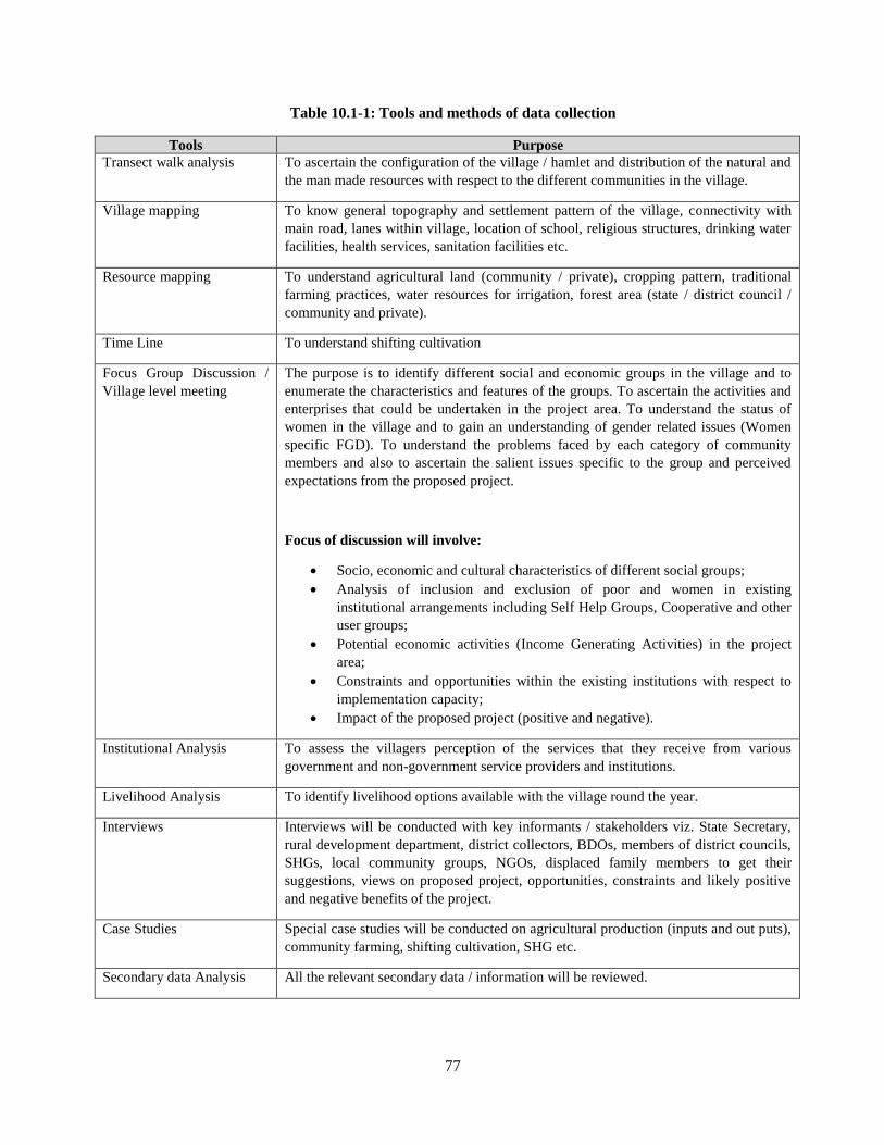
77
Table 10.1-1: Tools and methods of data collection
Tools Purpose
Transect walk analysis To ascertain the configuration of the village / hamlet and distribution of the natural and
the man made resources with respect to the different communities in the village.
Village mapping To know general topography and settlement pattern of the village, connectivity with
main road, lanes within village, location of school, religious structures, drinking water
facilities, health services, sanitation facilities etc.
Resource mapping To understand agricultural land (community / private), cropping pattern, traditional
farming practices, water resources for irrigation, forest area (state / district council /
community and private).
Time Line To understand shifting cultivation
Focus Group Discussion /
Village level meeting
The purpose is to identify different social and economic groups in the village and to
enumerate the characteristics and features of the groups. To ascertain the activities and
enterprises that could be undertaken in the project area. To understand the status of
women in the village and to gain an understanding of gender related issues (Women
specific FGD). To understand the problems faced by each category of community
members and also to ascertain the salient issues specific to the group and perceived
expectations from the proposed project.
Focus of discussion will involve:
Socio, economic and cultural characteristics of different social groups;
Analysis of inclusion and exclusion of poor and women in existing
institutional arrangements including Self Help Groups, Cooperative and other
user groups;
Potential economic activities (Income Generating Activities) in the project
area;
Constraints and opportunities within the existing institutions with respect to
implementation capacity;
Impact of the proposed project (positive and negative).
Institutional Analysis To assess the villagers perception of the services that they receive from various
government and non-government service providers and institutions.
Livelihood Analysis To identify livelihood options available with the village round the year.
Interviews Interviews will be conducted with key informants / stakeholders viz. State Secretary,
rural development department, district collectors, BDOs, members of district councils,
SHGs, local community groups, NGOs, displaced family members to get their
suggestions, views on proposed project, opportunities, constraints and likely positive
and negative benefits of the project.
Case Studies Special case studies will be conducted on agricultural production (inputs and out puts),
community farming, shifting cultivation, SHG etc.
Secondary data Analysis All the relevant secondary data / information will be reviewed.
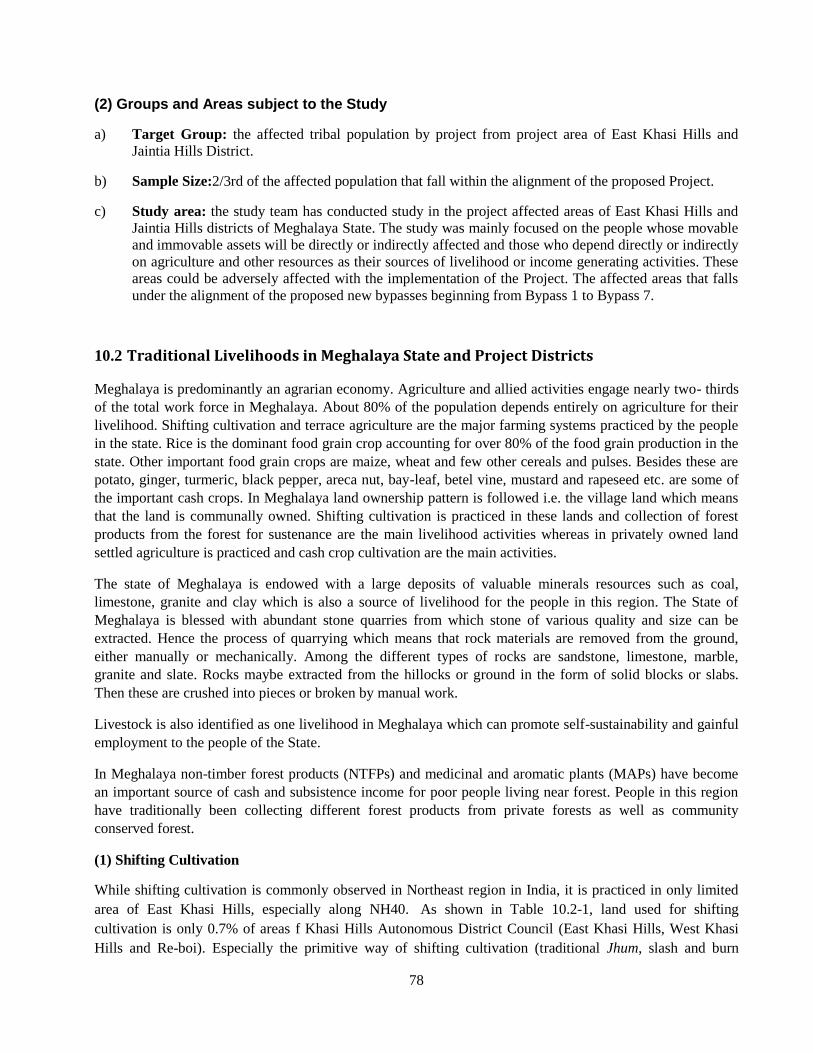
78
(2) Groups and Areas subject to the Study
a) Target Group: the affected tribal population by project from project area of East Khasi Hills and
Jaintia Hills District.
b) Sample Size:2/3rd of the affected population that fall within the alignment of the proposed Project.
c) Study area: the study team has conducted study in the project affected areas of East Khasi Hills and
Jaintia Hills districts of Meghalaya State. The study was mainly focused on the people whose movable
and immovable assets will be directly or indirectly affected and those who depend directly or indirectly
on agriculture and other resources as their sources of livelihood or income generating activities. These
areas could be adversely affected with the implementation of the Project. The affected areas that falls
under the alignment of the proposed new bypasses beginning from Bypass 1 to Bypass 7.
Traditional Livelihoods in Meghalaya State and Project Districts 10.2
Meghalaya is predominantly an agrarian economy. Agriculture and allied activities engage nearly two- thirds
of the total work force in Meghalaya. About 80% of the population depends entirely on agriculture for their
livelihood. Shifting cultivation and terrace agriculture are the major farming systems practiced by the people
in the state. Rice is the dominant food grain crop accounting for over 80% of the food grain production in the
state. Other important food grain crops are maize, wheat and few other cereals and pulses. Besides these are
potato, ginger, turmeric, black pepper, areca nut, bay-leaf, betel vine, mustard and rapeseed etc. are some of
the important cash crops. In Meghalaya land ownership pattern is followed i.e. the village land which means
that the land is communally owned. Shifting cultivation is practiced in these lands and collection of forest
products from the forest for sustenance are the main livelihood activities whereas in privately owned land
settled agriculture is practiced and cash crop cultivation are the main activities.
The state of Meghalaya is endowed with a large deposits of valuable minerals resources such as coal,
limestone, granite and clay which is also a source of livelihood for the people in this region. The State of
Meghalaya is blessed with abundant stone quarries from which stone of various quality and size can be
extracted. Hence the process of quarrying which means that rock materials are removed from the ground,
either manually or mechanically. Among the different types of rocks are sandstone, limestone, marble,
granite and slate. Rocks maybe extracted from the hillocks or ground in the form of solid blocks or slabs.
Then these are crushed into pieces or broken by manual work.
Livestock is also identified as one livelihood in Meghalaya which can promote self-sustainability and gainful
employment to the people of the State.
In Meghalaya non-timber forest products (NTFPs) and medicinal and aromatic plants (MAPs) have become
an important source of cash and subsistence income for poor people living near forest. People in this region
have traditionally been collecting different forest products from private forests as well as community
conserved forest.
(1) Shifting Cultivation
While shifting cultivation is commonly observed in Northeast region in India, it is practiced in only limited
area of East Khasi Hills, especially along NH40. As shown in Table 10.2-1, land used for shifting
cultivation is only 0.7% of areas f Khasi Hills Autonomous District Council (East Khasi Hills, West Khasi
Hills and Re-boi). Especially the primitive way of shifting cultivation (traditional Jhum, slash and burn
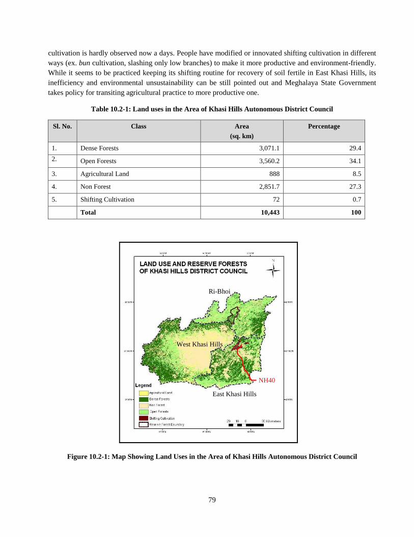
79
cultivation is hardly observed now a days. People have modified or innovated shifting cultivation in different
ways (ex. bun cultivation, slashing only low branches) to make it more productive and environment-friendly.
While it seems to be practiced keeping its shifting routine for recovery of soil fertile in East Khasi Hills, its
inefficiency and environmental unsustainability can be still pointed out and Meghalaya State Government
takes policy for transiting agricultural practice to more productive one.
Table 10.2-1: Land uses in the Area of Khasi Hills Autonomous District Council
Sl. No. Class Area
(sq. km)
Percentage
1. Dense Forests 3,071.1 29.4
2. Open Forests 3,560.2 34.1
3. Agricultural Land 888 8.5
4. Non Forest 2,851.7 27.3
5. Shifting Cultivation 72 0.7
Total 10,443 100
Figure 10.2-1: Map Showing Land Uses in the Area of Khasi Hills Autonomous District Council
Ri-Bhoi
West Khasi Hills
East Khasi Hills
NH40
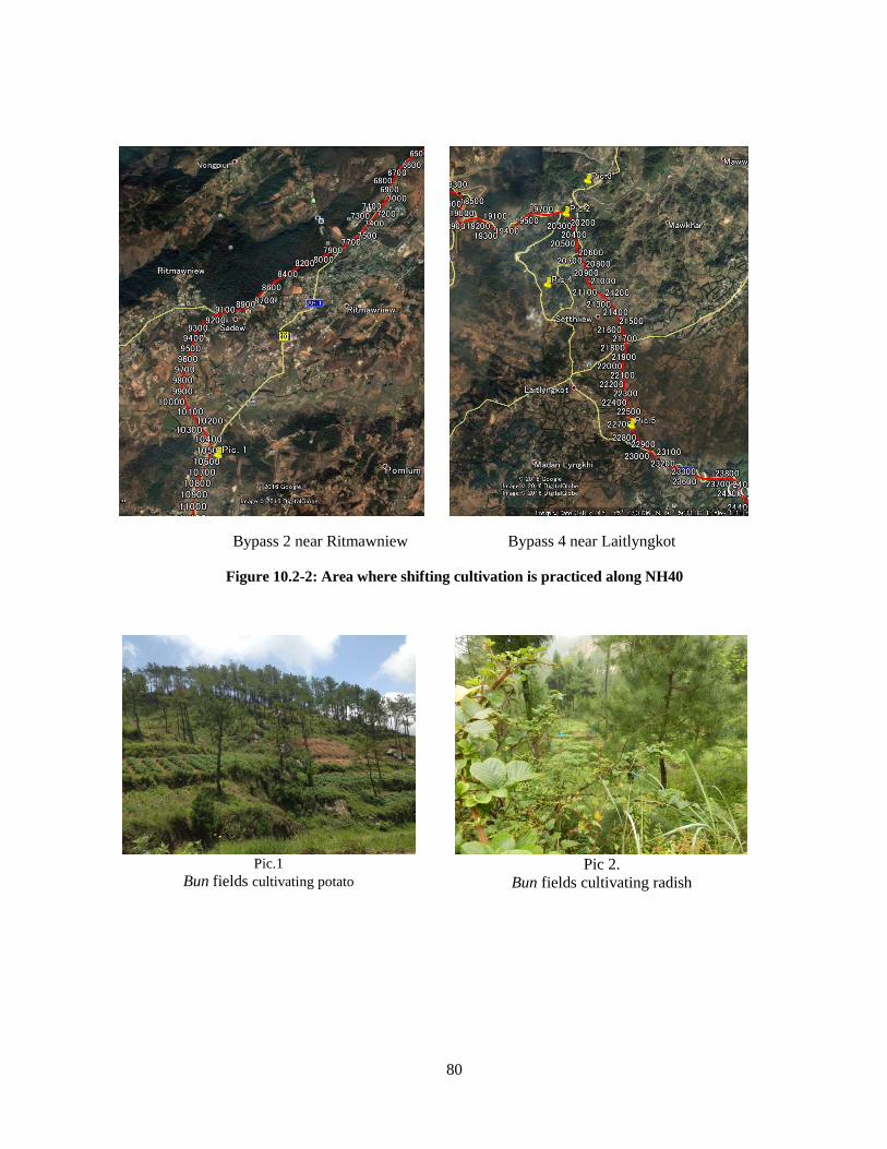
80
Bypass 2 near Ritmawniew Bypass 4 near Laitlyngkot
Figure 10.2-2: Area where shifting cultivation is practiced along NH40
Pic.1
Bun fields cultivating potato
Pic 2.
Bun fields cultivating radish
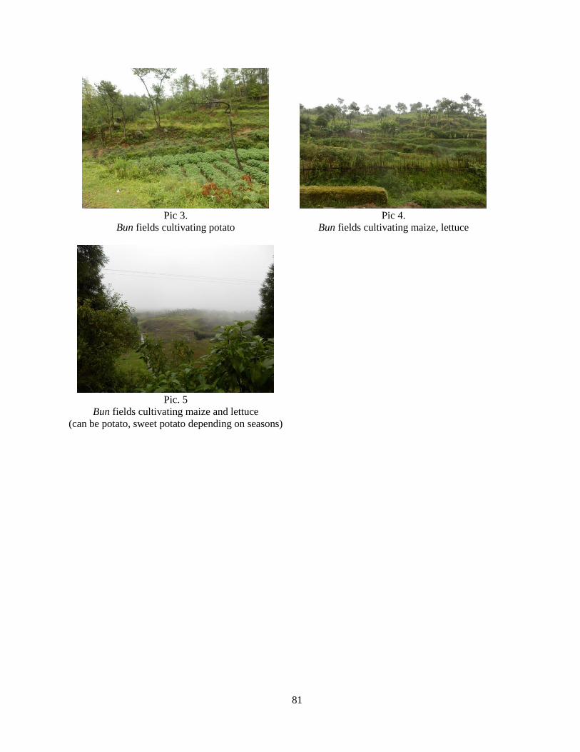
81
Pic 3.
Bun fields cultivating potato
Pic 4.
Bun fields cultivating maize, lettuce
Pic. 5
Bun fields cultivating maize and lettuce
(can be potato, sweet potato depending on seasons)
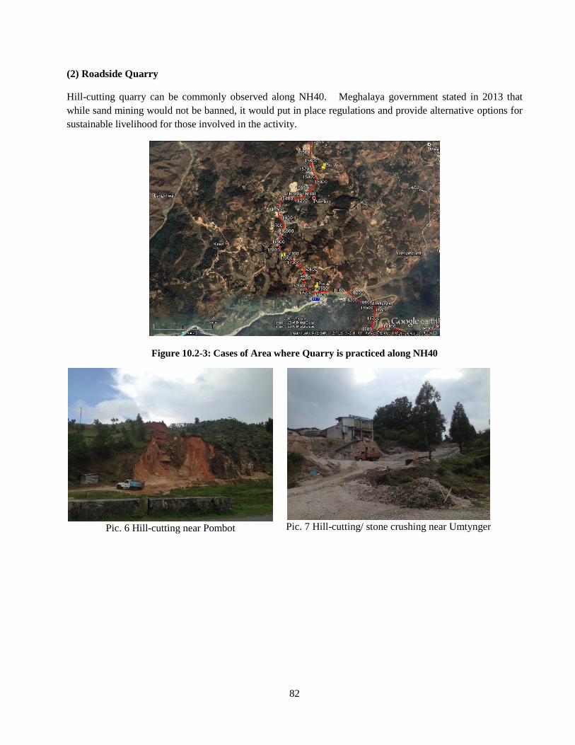
82
(2) Roadside Quarry
Hill-cutting quarry can be commonly observed along NH40. Meghalaya government stated in 2013 that
while sand mining would not be banned, it would put in place regulations and provide alternative options for
sustainable livelihood for those involved in the activity.
Figure 10.2-3: Cases of Area where Quarry is practiced along NH40
Pic. 6 Hill-cutting near Pombot
Pic. 7 Hill-cutting/ stone crushing near Umtynger
83
Public Consultation 10.3
The NGO - Tynrai Foundation conducted the first round of extensive consultation at community / village
level in the project area during August and September 2016. Community level consultation (Focus Group
Discussion and Interviews) were held with targeted beneficiaries and the primary stakeholders of the project
in 6 villages across the 2 districts of project area. These consultation included women, youth, BPL House
Holds, Self Help Group members, and the farmers. The consultation meetings also involved tribal and other
customary village leaders, members of village councils. The consultations were free, in local language, and
conducted with prior information disseminated through consultation team. The consultation indicated strong
demand and broad community support for livelihood interventions.
Table 10.3-1: Village wise consultation profile
Village Date/Time Location No. of Participant
(Male/Female)
MylliemRngi 6/09/2016 Community Hall of the Village 5 (Male-1, Female-4)
Umlympung 06/09/2016
Community Hall of the Village 33 (Male-11, Female-22)
Siatbakon 7/09/2016 Community Hall of the Village 33 (Male-10, Female-23)
Nongshyrngan 09/09/2016 Community Hall of the Village 29 (Male-12, Female-17)
Bakur 09/09/2016 Community Hall of the Village 18 (Male-8, Female-10)
Mylliem Madan
Iing Syiem
10/09/2016
Community Hall of the Village 19 (Male-2, Female-17)
10.3.1 Village wise FGD Findings
Following Table 10.3-2presents findings from village level Focus Group Discussion
Table 10.3-2: Focus Group Discussion Findings
Name of Village Findings from FGD/Meetings/Interaction
MylliemRngi [General]
Almost all the respondents are engaged in farming and do not have other
alternative livelihoods.
[Issues]
Existing traditional irrigation system will be disturbed due to the new road
alignment which will affect cultivated lands and production.
[Institutions for income generations/ alternative livelihoods]
The Mahatma Gandhi National Rural Employment Guarantee Scheme is
implemented in this village and provides jobs at least for 50 to 100 days in a year.
MylliemMadanIingSyiem [General]
The main income generating activities in this village come from agriculture and
small enterprises such as tea stalls, vegetable vendors, small grocery shops and car
washing centres.
[Issues]
The main constraints faced by the people of this village are the acquisition of
private land and have concerns over the compensatory mechanisms.
84
Short term benefits are the employment opportunities such as employment in road
construction; make shift stalls and related activities.
[Institutions for income generations/ alternative livelihoods]
There are existing women Self Help Groups (SHGs) that mainly assist members
during special events that happen in the village. These SHGs do not take any
financial help from other sources.
The schemes that are available in this village are those of the PWD and
MGNREGS
There is no existing or functioning NGO and no other schemes or
trainings/capacity building have taken place in this village according to the
Communtiy.
Umlympung [Issues]
The main concern of the Community is the impact of livelihood sincewith the
coming of the proposed Project as most of them have the community members are
engaged in small scale enterprises (Tea stalls/food stalls along the existing roa
[Institutions for income generations/ alternative livelihoods]
Schemes present are, the Mahatma Gandhi National Rural Employment Guarantee
Scheme which is availed by many of the villagers here providing 100 days of work
at Rs 163/- daily wage.
The village was also to avail MLA scheme for development of this village.
Siatbakon [General]
The main income generating activities in this village come from broom cultivation
and small scale enterprises.
[Institutions for income generations/ alternative livelihoods]
There is no existing or functioning NGO and no other schemes or
trainings/capacity building have taken place in this village
The only government scheme that is available in this village is the MGNREGS
scheme.
Nongshyrngan [General]
There are no Sacred Forests that are affected, no traditional land practice; however
one Stone Monument (Monolith) which is present in the village will be affected.
About the medicinal plant there was one Garden owned by the 4 clans.
[Institutions for income generations/ alternative livelihoods]
The NGOs that was MRDS (Meghalaya Rural Development scheme). MRDS
(Meghalaya Rural Development society) is the only project that was functioning
till 2012 providing Livelihood Opportunity such as Mushroom Cultivation they
also provide seeds to the farmers for cultivation.
The scheme that is implemented is only MGNREGS
Bakur [General]
There is no culturally important facets like the Sacred Forests or Monoliths.
[Institutions for income generations/ alternative livelihoods]
There were a number of organisations that were known to the villagers, but
currently defunct and not active. Presently there are a number of pressure groups
such as WJYC (West Jaintia Youth Council), KSU (Khasi Students Union), HNYF
(Hynniewtrep National Youth Federation), and Women Organizations working in
these areas. These groups are not government sponsored therefore making them
illegible to implement any scheme(s) in the designated areas.
These pressure groups however act as a monitoring body of the people in those
areas by keeping a check on the existing government activities.
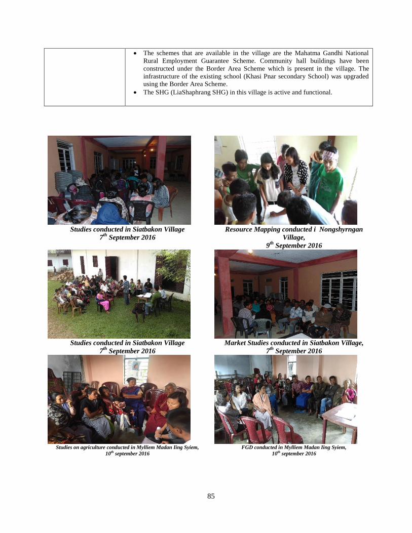
85
The schemes that are available in the village are the Mahatma Gandhi National
Rural Employment Guarantee Scheme. Community hall buildings have been
constructed under the Border Area Scheme which is present in the village. The
infrastructure of the existing school (Khasi Pnar secondary School) was upgraded
using the Border Area Scheme.
The SHG (LiaShaphrang SHG) in this village is active and functional.
Studies conducted in Siatbakon Village
7th
September 2016
Resource Mapping conducted i Nongshyrngan
Village,
9th
September 2016
Studies conducted in Siatbakon Village
7th
September 2016
Market Studies conducted in Siatbakon Village,
7th
September 2016
Studies on agriculture conducted in Mylliem Madan Iing Syiem,
10th september 2016 FGD conducted in Mylliem Madan Iing Syiem,
10th september 2016
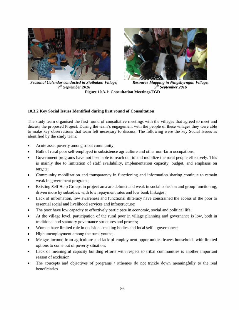
86
Seasonal Calendar conducted in Siatbakon Village,
7th
September 2016
Resource Mapping in Ningshyrngan Village,
9th
September 2016
Figure 10.3-1: Consultation Meetings/FGD
10.3.2 Key Social Issues Identified during first round of Consultation
The study team organised the first round of consultative meetings with the villages that agreed to meet and
discuss the proposed Project. During the team’s engagement with the people of these villages they were able
to make key observations that team felt necessary to discuss. The following were the key Social Issues as
identified by the study team:
Acute asset poverty among tribal community;
Bulk of rural poor self-employed in subsistence agriculture and other non-farm occupations;
Government programs have not been able to reach out to and mobilize the rural people effectively. This
is mainly due to limitation of staff availability, implementation capacity, budget, and emphasis on
targets;
Community mobilization and transparency in functioning and information sharing continue to remain
weak in government programs;
Existing Self Help Groups in project area are defunct and weak in social cohesion and group functioning,
driven more by subsidies, with low repayment rates and low bank linkages;
Lack of information, low awareness and functional illiteracy have constrained the access of the poor to
essential social and livelihood services and infrastructure;
The poor have low capacity to effectively participate in economic, social and political life;
At the village level, participation of the rural poor in village planning and governance is low, both in
traditional and statutory governance structures and process;
Women have limited role in decision - making bodies and local self – governance;
High unemployment among the rural youths;
Meagre income from agriculture and lack of employment opportunities leaves households with limited
options to come out of poverty situation;
Lack of meaningful capacity building efforts with respect to tribal communities is another important
reason of exclusion;
The concepts and objectives of programs / schemes do not trickle down meaningfully to the real
beneficiaries.
87
Market, Distribution and Processing of Agricultural / Non – Agricultural Produces 10.4
10.4.1 Background
There are two kinds of rural market places, i.e., (i) periodic (primary) market places occurring with eight days
rotation are majority; these are big and large-scale markets as well as small markets (depending on the
location) composed of farmers, traders, middle men, small retail traders, and have a mix of permanent
(established), temporary (un-established), and road side shops, and (ii) daily market places, located nearby in
the area but are small-sized market places with retailers providing wide variety of products to meet daily
necessities. The latter do not exist in all parts of all the districts as there are only ten or more places that have
this kind of rural market in the state.
10.4.2 Management System of Markets
The management system of markets differs in areas except for two regulated markets managed directly by the
Meghalaya Agricultural Marketing Board (MAMB).
Khasi Hills: Most of the rural markets are under the Syiem and his Durbar who have the right to collect a
customary toll called “Ka Musur” and “Ka Bainguh Syiem” for all types of commercial goods, including
Certificate of Origin (CO) on forest for all forest products at any revenue station authorised by the Syiem and
Durbar. It is preferred that the right to collect customary toll and market toll, as far as practicable, be done
through public auction as may be decided by the Syiem and Durbar.
Garo Hills: The rural markets along with toll gates in Garo Region are managed by the Garo Hills
Autonomous District Council (GHADC). The markets are leased annually or for a five-year term (depending
on the term of the ruling party) by inviting bids. GHADC receives money from the lessee of which 10% is
retained by GHADC, and the rest goes to the concerned Nokma and his Durbar.
Jaintia Hills: The market system in Jaintia Hills is governed by the United Khasi-Jaintia Hills Autonomous
District Council (JHADC) Act, 1959. However, there are nine markets directly under JHADC, five private
markets under JHADC control, and eight religious/ Elaka markets run by respective Daloi’s of that Elaka.
The revenue collected from the markets under JHADC control comes in full to JHADC. For private markets
which are under JHADC control, JHADC receives 50% of the gross income of all private markets. For the
markets under 100% control of Daloi of Elaka (s), 100% revenue is retained by Daloi of the Elaka and his
Durbar.
The rural markets in Meghalaya and Project Districts generally perform three functions, viz, (i) selling of
local produce within the area, (ii) assembly of local products for selling to other areas, and (iii) retailing of
wholesale lots from other areas in the local area. The selling of local produce to traders and consumers is the
predominant activity in these markets. Here farmers represent the biggest group either as sellers or as buyers.
At times, farmers retail their produce and become traders also. Besides, goods that are not produced locally,
are brought by smaller and occasional traders to retail to the local population. These markets, through their
interconnections, are the farmer's main connection point with both inter- and intra-regional marketing system.
The condition of such connection is restricted and localised to certain specific areas due to geophysical
conditions as well as condition of infrastructure facilities.
88
10.4.3 Market Study of Project Area
Market Study was conducted in the Project area out market systems, condition of existing markets, turn over,
distribution rout and characteristics of distribution system, international trade with Bangladesh etc.
The main wholesale market that is situated in between this bypass is at Pynursla village. Other markets are
Bara bazaar in the main city of Shillong and also in Dawki village (border of Bangladesh) which act as a
wholesale market as it is a border area where export of goods to Jowai and Bangladesh occurs. From this
study, it shows that the market system in this area is not well defined as almost the entire marketing system is
unorganized and exists in the form of traditional ‘Haats’ and weekly ‘bazaars’.
The weekly bazaars in this area occur twice a week at Pynursla and Dawki, once a week at Laitlyngkot and
Iewwahlyngkhat and whereas in Shillong, which is the main market for many of the villages in this bypass,
the market is an everyday affair. All these markets serve as a means of exchanging goods for the people from
rural areas and urban areas. This renders the job of determining the commodity-wise and district-wise
marketable surplus very difficult. The situation is further compounded by the fact that a chain of middle-men
(person or company that connects buyers with sellers) operate as transporters and traders between the farm-
gate and the markets within the state as well as outside including the markets in neighbouring Bangladesh.
The problems that exist in the market system in Meghalaya are that, the farmers do not have a proper storage
room for raw materials in which they have to sell their products at low prices, also there is competition over
raw materials within the local markets leading to fluctuation of prices, but no small cottage industries to
convert the raw materials into finished products. Only with the existence of small cottage industries will the
farmers be able to convert the raw materials into different kinds of produce and this will in turn have an
impact in the overall market system in Meghalaya as well as in the whole of Northeast India.
The State Agricultural Produce Marketing Act was enacted in the year 1980 and the State Agricultural
Marketing Board was set up in 1983, to develop marketing infrastructural facilities and to provide marketing
support to the farmers in the State. In the year 1991, with the assistance of the Centre for Agricultural
Marketing, Government of India located at Jaipur, detailed survey was conducted and a project profile for
development of marketing infrastructure in Meghalaya was prepared. Accordingly, it was proposed to set up
secondary markets in each District in the State which are called Wholesale Regulated Market. Thus, land was
made available at Mawiong in the East Khasi-Hills District, Garobadha in the West Garo Hills District and
William nagar in the East Garo Hills District.
10.4.4 Market system:
It is a process of networks of buyers, sellers and other actors that come together to trade in a given product or
service. The participants in a market system include direct market players:-
i) Producers: A producer is someone who creates and supplies goods or services;
ii) Buyers: A buyer is one who engages in the purchase or acquisition of a part or the entire business
organization;
iii) Consumers: A consumer is a person (or group) who pays to consume the goods and/or services
produced by a seller.
89
10.4.5 Marketing Channels:
Agricultural produce is normally channeled through the following types of market:
a) Rural Primary Markets: In rural markets, trade is characterized by direct sales of small quantities of
produce by producers to village traders and by sales by retailers to rural consumers. Rural markets
form part of a trade network and are normally arranged on a periodic basis on specific weekdays, and
are commonly organized at a central place in a village or district centre or beside the village’s access
road. In some instances, provincial and district-level markets also serve this function, as well as
providing an assembly function (i.e. assembling produce in larger quantities for onward sale to outside
buyers).
b) Assembly Markets: Larger rural markets are found where greater quantities of produce are traded,
either by the producers themselves or by traders. These “assembly” markets (often combined with local
rural markets), are normally situated on main highways, or near to ferries and other local transport
nodes. Produce is predominantly bought by traders or collection agents on their own behalf or on
behalf of urban wholesalers.
c) Wholesale Markets: Terminal wholesale and semi-wholesale markets are located within or near major
cities. These markets may be supplied by purchasing or assembly centres in the rural areas or directly
from farms, either by traders or by large farmers. Transactions are predominantly handled by traders
although many wholesale markets incorporate “farmers’ markets” where farmers can sell directly to
retailers. Some markets also allow traders to sell to retailers “off the back of the truck”.
d) Retail Markets: These are markets directly serving consumers and are found in main urban areas,
such as provincial, town and city centers. Although primarily retail, they may have some semi-
wholesale functions, particularly if they allow farmers to trade. In that case, they are often called
farmers’ markets.
e) Other Marketing Channels: Channels other than markets often exist, particularly in the case of
horticultural produce. These include on-farm sales, where collectors purchase the produce (usually
under contracts between the producers and distributors) and arrange transport to wholesale outlets,
packing houses or supermarkets. The extent to which this is done depends primarily on the general
state of development of the economy and the demands of consumers.
10.4.6 Findings of Market Study
To understand market situation, a study was conducted in the project area. The study was mainly focused on:
1. To understand the economic status of the farmers and shopkeepers within project area; and
2. To find out the flow of the marketing system/market service provided by the farmer.
A questionnaire was used as a tool of data / information collection. Followings are the key findings of the
study:
• Most of the respondents (86%) are females whereas 14% are male which show that the women are
more engaged in daily activities;
90
• Most of the respondents (57%) have passed their schooling till high school whereas around 43% have
cleared only up to class 5th;
• Around 86% of the respondents have families comprising of 8-10 member and 14% of the respondents
have families with 5-7 members which is still a big family by modern standards. This shows that
people in this area do not give any importance to family planning which is an important factor to take
into account with regards to socio-economic aspect;
• Among the respondents, 57% are depend on farming as a primary occupation and 43% depend on local
businesses such as animal husbandry, car wash services, stone quarries as secondary occupation;
• Most of the houses of the respondents who will be affected along the Bypass are pucca houses
constituting of about 57% and kutcha houses around 43%;
• Among the respondents, 29% of the respondents have their own land for agriculture, 57% have their
own shops on their own lands and 14% of the respondents have rented out shops along the ROW;
• Around 75% of the respondents travel to Shillong market for acquiring goods whereas 25% go to 7th
mile market for the same;
• With regards to owning land, 57% use the land for cultivation, 29% cultivate the land for own
consumption and the remaining 14% lease out the land to others;
• Around 71% of the respondents carry their products from the fields to the main road by themselves
since they have their lands close to or just by the roadside and around 21% depend on hired labourers
to carry their goods to the main road;
• Among these respondents, 14% earn a montly income ranging between ₹ 5,000-10,000, another 14%
earn between ₹ 25,000-30,000, 29% earn more than ₹ 30,000 and 43% of the respondents however do
not keep any record of their earnings and savings;
• On a weekly basis, 43% of the respondents spend around ₹ 350 on their goods, another 43% spend ₹
200 and the remaining 14% spend ₹ 450;
• Among the respondents, 43% of the respondent sell their product in the village itself, 43% in Shillong
market and 14% in 7th Mile market depending on the quantity of the products;
• The time of the year when the production is less for 14 % of the respondents is during the month of
Jan-Feb since it is the sowing season and the rest of the 86% of the respondents do not keep records;
please clarify.
• All the respondents say that they do not have bargaining power when it comes to buying or selling their
products in the market because the prices are all fixed by the middlemen in the market place;
• There is no association or welfare group in the village to look after their grief or interest;
• Around 71% of the respondents say that there is no Self Help Group in the village while 29% do not
have any knowledge about the existence of any SHG;
• All the women play a major role in income generating activities since they are directly involved in the
exchange of goods in the market, the sowing and reaping process in the agricultural fields as well;
• All the land used for settlement, for cultivation or for other business purposes belongs entirely to the
women respondents;
• Around 86% of the respondents say that there is a need for training/building capacity for the women of
the region, whereas the remaining 14% says that the training will be of little or no help at all since they
will not have time to attend such trainings;
91
• Almost 57% of the respondents expressed that fluctuation in prices of goods do not affect them at all
since they also have their secondary occupations to support them, whereas the other 43% say that price
fluctuation does affect them since they have no other alternative sources of income;
• Among the respondents 43% feel that the presence of middlemen affect their income and the flow of
money from the producer to the consumer and vice versa whereas the 57% of the respondent say that it
does not affect them at all;
• Among the respondents, 57% say that changes in the climate does affect their daily activities because
the crops are affected and the other 43% says that it does not affect their daily activities;
• Around 57% of the respondents have to pay taxes to the custodian of the market normally the Syiem of
Mylliem while selling their goods in the Shillong market only. Whereas the rest do not have to pay any
tax as they sell their product in their own village or other nearby market;
• Among the respondents, around 57% face the problem of monopoly in the market while 43% say that it
does not affect them as they are not solely dependent on only one market;
• Around 29% of the respondents say that the reason for change in the system of market in last five years
is due to lack of labour, 29% say it is due to competition with other local markets, 28% say that it is
due to income patterns, while 14% say it is due to loss of income caused by the intrusion of outsiders
coming into the same market.
10.4.7 Suggestions and Recommendations
In the different interviews with the respondents, they have mentioned that there is no association or group of
people that work or look after the welfare or interest of these different groups of people in the different
villages within project area. Therefore it was suggested by the people if the government could provide
mechanisms that can help or that can look into such issues.
Opinions of the Project Affected Persons (PAP) about the Project- A positive response from them
altogether was received for the project. However compensation must be given to them based on the proper
valuation of their assets especially their lands, Residential and Commercial structures and other assets.
92
Livelihood Frameworks 10.5
Participatory identification and selection of affected beneficiaries, individually or collectively;
Targeting of excluded and vulnerable areas and communities;
Regular informed consultations and information dissemination in the project area;
Focused information and communication campaign in project area;
Social mobilization of identified affected HH and beneficiaries;
Representation of women, youth and other tribal households in livelihood programs;
Participatory planning for livelihoods, community infrastructure and natural resource management;
Community based Grievance Redress System, linked to customary systems of conflict and grievance
resolution;
Targeted planning and allocation of economic and livelihoods assistance;
Sensitization and capacity building of project staff and partners
10.5.1 Gender Strategy
Participation of women would be key factor in implementing social inclusion while the Study focuses on
women’s mobilization and empowerment as a core intervention and strategy, it would need an additional
actions to address the gender inequities in project area, especially those related to identification of women
headed households, women’s lack of information, participation in decision-making etc. The gender strategy
will be based on:
Exclusive women’s SHGs promoted based on affinity;
Targeted identification and mobilization of women – headed households, widows, destitute and deserted
women;
Orientation and training of project staff on gender issue in project area;
Gender sensitization;
Training / capacity building on women’s leadership;
Ensuring women’s participation and representation in planning and implementation of livelihoods plan;
Convergence of other programs and schemes for women.
10.5.2 Identified Alternative Livelihoods
The identification, selection and development of income generating activities intended for the
villages along the NH-40 must be deemed as important if the proposed Project is to be implemented. If
households and enterprises are to be displaced, they would need adequate resources to fall back on in times of
need and this means finding alternative methods of income generation. Livelihoods are made up of skills,
technologies, organisations and finances that are built up over time for people to make a living and have a
good quality of life. Listed below is some of the alternative livelihood options identified based on the
diversity of resources, skills and technologies they are able to access.
Agricultural diversification: it means intensifying inputs like labour etc in one small piece of land
instead of a huge area of land and incorporate new technology with their traditional methods of
farming;
93
Rural livelihood diversification: the process by which rural families construct a diverse portfolio of
activities and social support capabilities in order to survive and improve their standard of living. The
determinants and effects of diversification in the areas of poverty, income distribution, farm output and
gender are examined;
Government intervention for livelihood options;
Temporary livelihood options in the form of daily wage especially for the landless people;
Promoting Apiculture (bee- keeping) apiculture can play a vital role in the livelihood promotion of the
farmers in Meghalaya;
Training in agro processing activities refers manufacturing the raw materials and intermediate products
derived from the agricultural sector. Agro processing industry thus means transforming products
originating from agriculture, forestry and fishery;
Training in embroidery and tailoring this can also be another form of alternative livelihood for the
people in the affected areas especially the women.
Eco-Tourism is another important livelihood option that can be looked into. Eco-Tourism directed
towards exotic natural environments, intended to support conservation efforts ad observe wildlife. It is
possible to develop eco-tourist spots within East Khasi Hills and West Jaintia Hills in Meghalaya due
to its scenic beauty. There are waterfalls such as Byrdaw Falls (Pomshutia), Elephant Falls (near
Pomlum) which are tourist attractions that fall within the NH-40. There are also a few areas used for
camping sites and other outdoor activities near Dawki (Shnongpdeng being one of the major tourist
attraction spots) which contribute to the tourism of Meghalaya. Such tourist spots and areas can be
identified and developed to bring in more tourists to the state of Meghalaya. On the hindsight, careful
steps must be taken to not overburden the already existing tourist spots which will result in pollution
and huge amount of Footfalls. The villagers of these areas can be taken into confidence with multiple
consultations to identify such areas to boost the village economy and also provide an alternative
livelihood option for them.
10.5.3 Linkage with Meghalaya State Rural Livelihoods Mission
As per the guidelines of National Rural Livelihood Mission (NRLM), the Government of Meghalaya has
formed a state society in the name - Meghalaya State Rural Livelihoods Society (MSRLS). The society is
registered under the Meghalaya Society Registration Act XII of 1983 and was designated as the Nodal
Agency for implementing NRLM in the state. The basic purpose of forming this society is to put in place a
dedicated and sensitive support structure from the State level down to the sub-district level which will focus
on building strong and self-managed institution of the poor at different levels. This will provide the poor a
platform for collective action based on self-help and mutual cooperation, build linkages with mainstream
financial institutions and Government departments to address the multi-faceted dimensions of rural poverty.
The study will focus more on understanding the mission and linking it with project affected area beneficiaries.
Apart from this mission, the study will also concentrate on various State Government schemes appropriate in
the project affected area, these are
Chief minister’s rural development fund (CMRDF);
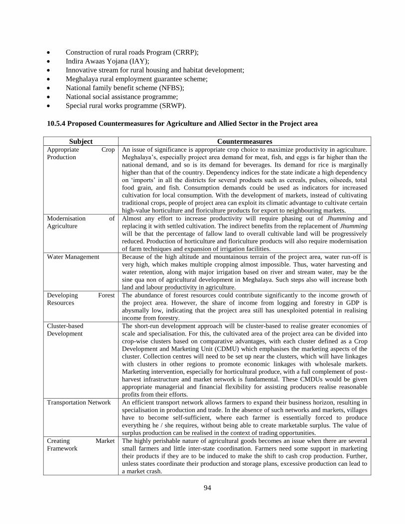
94
Construction of rural roads Program (CRRP);
Indira Awaas Yojana (IAY);
Innovative stream for rural housing and habitat development;
Meghalaya rural employment guarantee scheme;
National family benefit scheme (NFBS);
National social assistance programme;
Special rural works programme (SRWP).
10.5.4 Proposed Countermeasures for Agriculture and Allied Sector in the Project area
Subject Countermeasures Appropriate Crop
Production
An issue of significance is appropriate crop choice to maximize productivity in agriculture.
Meghalaya’s, especially project area demand for meat, fish, and eggs is far higher than the
national demand, and so is its demand for beverages. Its demand for rice is marginally
higher than that of the country. Dependency indices for the state indicate a high dependency
on ‘imports’ in all the districts for several products such as cereals, pulses, oilseeds, total
food grain, and fish. Consumption demands could be used as indicators for increased
cultivation for local consumption. With the development of markets, instead of cultivating
traditional crops, people of project area can exploit its climatic advantage to cultivate certain
high-value horticulture and floriculture products for export to neighbouring markets.
Modernisation of
Agriculture
Almost any effort to increase productivity will require phasing out of Jhumming and
replacing it with settled cultivation. The indirect benefits from the replacement of Jhumming
will be that the percentage of fallow land to overall cultivable land will be progressively
reduced. Production of horticulture and floriculture products will also require modernisation
of farm techniques and expansion of irrigation facilities.
Water Management Because of the high altitude and mountainous terrain of the project area, water run-off is
very high, which makes multiple cropping almost impossible. Thus, water harvesting and
water retention, along with major irrigation based on river and stream water, may be the
sine qua non of agricultural development in Meghalaya. Such steps also will increase both
land and labour productivity in agriculture.
Developing Forest
Resources
The abundance of forest resources could contribute significantly to the income growth of
the project area. However, the share of income from logging and forestry in GDP is
abysmally low, indicating that the project area still has unexploited potential in realising
income from forestry.
Cluster-based
Development
The short-run development approach will be cluster-based to realise greater economies of
scale and specialisation. For this, the cultivated area of the project area can be divided into
crop-wise clusters based on comparative advantages, with each cluster defined as a Crop
Development and Marketing Unit (CDMU) which emphasises the marketing aspects of the
cluster. Collection centres will need to be set up near the clusters, which will have linkages
with clusters in other regions to promote economic linkages with wholesale markets.
Marketing intervention, especially for horticultural produce, with a full complement of post-
harvest infrastructure and market network is fundamental. These CMDUs would be given
appropriate managerial and financial flexibility for assisting producers realise reasonable
profits from their efforts.
Transportation Network An efficient transport network allows farmers to expand their business horizon, resulting in
specialisation in production and trade. In the absence of such networks and markets, villages
have to become self-sufficient, where each farmer is essentially forced to produce
everything he / she requires, without being able to create marketable surplus. The value of
surplus production can be realised in the context of trading opportunities.
Creating Market
Framework
The highly perishable nature of agricultural goods becomes an issue when there are several
small farmers and little inter-state coordination. Farmers need some support in marketing
their products if they are to be induced to make the shift to cash crop production. Further,
unless states coordinate their production and storage plans, excessive production can lead to
a market crash.
95
Agro-based Industry There is a link between productivity, trade, and urbanisation. The rate of urbanisation
crucially depends upon the rate of industrialisation. Thus, in order to increase labour
productivity in the project districts, one should focus on creating agro-based industrial
clusters in project districts having strong forward and backward linkages. The success of
such agro-based industrialisation will depend upon (i) the creation of markets and (ii)
efficient and reliable transport connectivity. The important initiatives in this regard will
have to include a thrust on improving the value chains. The private sector will have to play a
crucial role in making investments not only in agro-based industries but also in building the
infrastructure for improving the value chain through public-private partnerships (PPP).
Source: Meghalaya Vision 2030
In the project area where over half the population is below the poverty line, harnessing water is at the heart of
alleviating poverty by providing livelihood opportunities to the rural poor. The Government of Meghalaya
has launched a programme called ‘Integrated Basin Development and Livelihood Promotion (IBDLP)’. The
thrust areas of the IBDLP include integrated water resources management, creation of small multipurpose
reservoirs (SMRs), and generating water-centric livelihoods such as fisheries and aqua tourism. The objective
is not only to capture surface run-off and water along the drainage lines and reduce erosion but also to
formulate a water policy and aim at better river governance. The SMRs will be used for various productive
purposes like aquaculture, drinking water supply, mini-hydro irrigation, aesthetic value, tourism, and eco-
system promotion. Considerable investments are supposed to be made in this flagship programme. Therefore,
it is recommended to link affected people those who are interested in water resource management in their
fields with IBDLP.
10.5.5 Integrated Basin Development and Livelihood Promotion Programme (IBDLP)
The Integrated Basin Development and Livelihood Programme (IBDLP) was launched in April 2012 as a
flagship programme co-terminus with the State’s 12th Plan. The program aims to put Meghalaya on a higher
growth trajectory during this plan period and improve the quality of life and well-being of all its citizens.
As the program has an ambitious, challenging and ideal concept, it presumes every individual of the state to
produce anything for the market as an entrepreneur. The program plans to concentrate all resources to support
such individuals and foster real entrepreneurs who can manage their business by themselves.
The Meghalaya Institute of Entrepreneurship (MIE) has been set up as the nodal institution to facilitate the
setting up of entrepreneurs under the IBDLP. Followings are focus areas of MIE:
Training basic skills of managing enterprises in case of enterprises linked to agriculture. In general,
training provided by agriculture-related departments is technical in nature, not so much focusing on the
business. MIE emphasizes on looking at the agriculture value chain, and tries to fill up the gaps like
those related to post-harvest and packaging. As there is limited business orientation amongst people
involved in agriculture, it is quite challenging to provide training in agriculture sector-related enterprises;
On demand, MIE offers training services to line departments that include training of beneficiaries and
officials. Most of the training for the officials is on development orientation of the importance of
marketing;
96
MIE considers that there are four priority groups of participants, i.e., Priority 1: Ready for business;
Priority 2: Need exposure and training; Priority 3: Need detailed support; Priority 4; Persons not
knowing what to do. MIE is more focused on imparting training to the Priority 4 group of participants, as
its focus is bottom up approach;
10.5.6 Farmers Organizations and Livelihoods
Overview
Cooperatives of various types, self-help groups (SHG), farmers’ clubs, farmer’s producers organisations,
growers association, fisheries groups, and water users’ association (WUA) for irrigation have been formed in
Meghalaya. SHGs are now being promoted by Meghalaya State Rural Livelihood Society (MSRLS under
NRLM) and other SHG support organisations.
Cooperatives
The number of cooperatives in Meghalaya has grown in the past ten years. Around 1,410 cooperatives are
registered and engaged in various activities including agriculture, dairy, fisheries, horticulture, and marketing.
Out of the total, 360 multipurpose cooperatives and 172 primary agriculture credit societies are functional.
Twenty-five cooperatives are engaged in marketing of agricultural and horticultural produces. Maximum
numbers of the cooperatives have been formed in East Khasi Hills District accounting for 293 cooperatives or
20.8% of the total number of cooperatives in the state. There are 89 women cooperatives, of which 16
cooperatives are not functioning.
It is recommended that the respective project affected people should be linked with respective cooperative in
the project area.
Self Help Groups (SHGs)
SHGs in Meghalaya are formed under the auspices of Swarnajayanti Gram Swarojgar Yojna (SGSY) and
other projects/schemes like north eastern region community resource management project (NERCORMP).
NABARD is also promoting SHGs through 13 SHG promoting institutions and organised 1,779 SHGs so far.
However, due to the lack of the integrated monitoring system of the status of the SHGs, the Survey Team was
unable to understand the overall condition of the SHGs in the state. Meghalaya State Rural Livelihood
Society is in the process of reorganising SHGs formed under SGSY and organising new ones and also
establishing MIS to monitor the status.
Some of the SHGs formed under the integrated watershed management project (IWMP) and NERCORMP
are engaged in income generation activities of vegetable cultivation, processing food, making vermin
compost, handicraft making, processing non timber forest products (NTFPs), etc.
97
As of 31st March 2014, 3,075 SHGs in Meghalaya have outstanding loans amounting to Rs. 126.82 million.
In the case of SHG bank linkages, the transaction cost for accessing financial and other support services is
high because of the terrain and limited presence of service providers. The outreach of banks and other
financial institutions is poor in the remote areas. Many of the borrowers become defaulters not because they
do not want to make the repayment but due to the cost and time required to reach the bank. They have to
travel quite far and spend time and money to come to the bank for repayment.
It is therefore recommended to focus on non-functional SHGs to make them functional and formation of new
SHGs of project affected women groups in the project area.
10.5.7 Issues and Possible Counter Measures
In order to achieve the agricultural development in the project area, all the allied sectors contributing to the
food production are to be developed by strategic interventions based on the existing production systems in
each sector. The result of SWOT analysis and recommendation of countermeasures are as follows.
98
REHABILITATION PLAN Chapter 11
Rehabilitation Plan 11.1
The rehabilitation plan should consider the present socio-economic status of the PAPs. The survey conducted
as such reflects this information and helps in formulating a plan that considers the peoples current way of life
and how a new environment can better their standard of living. A key objective of RAP is to enhance the
livelihood of PAPs and ensure that their resettlement is not sinking their quality of life. Rehabilitation is to be
developed and implemented by the State Government; inputs and feedback from relevant
stakeholder/communities must be incorporated in the plan through a series of discussions and workshops. The
plan should be outlined within the framework of the policies and guidelines of JICA and the State/Country
policy.
The following will benefit from Rehabilitation Plan in this project;
- Agricultural Land affected by the project, PAPs working at sand and quarrying
- Residents whose occupation affected directly (resettlement) or indirectly (decreasing income by
construction of bypass) by the project.
It shall be noted here that Rehabilitation Plan in this report is still a proposal, and Resettlement and
Rehabilitation Plan will be drafted by each DC followed by Social Impact Assessment Procedures.
Accordingly, information presented in Chapter 10 and suggestions in Chapter 11 should be considered by
DCs. Implementation of R&R plan is responsibilities of DCs and NHIDCL, with support of Implementing
NGOs.
Measure 1. Job Training
Purpose: - Train for earning by new occupation
Countermeasure: -Survey the applicants and their demand for new occupation.
-Based on possibility of project, market and advice from Experts, consider
contents of job training.
-Programs of seminar or practice for job training
-Provide the opportunity of job training
Measure 2. Provide and enhance the chance of Employment
Purpose: -Increase the production of existing agriculture and quarrying etc.
Countermeasure: -Based on survey of household livelihood and opinion of PAPs, consider measures
to provide and enhance.
-Consider according to expert’s advice based on possibility of project and market
-Consider reduction of individual expense, such as leased land or group purchase in
case of land expansion
Measure 3. Financial Support
Purpose: -Better economic situation after resettlement
Countermeasure: -Establishment of Microfinance (Low / Non interest)
-Subsidy
99
Measure 4. Employment in short term
Purpose: -Make opportunity of short term employment in relocated place until getting stable
income by the main job.
Countermeasure: -Make opportunity of short term employment
The following points can be taken as reference:-
a).Skill gap assessment in the project area:
It is possible that the PAPs may have potentials and innate skills that could raise their income, but may not
be aware or is challenged in proceeding forward with the skill due to reasons of poverty or capacity- eg in
marketing, production and sustenance. The State can explore possibility of conducting a Skill mapping in the
area, which does have to be exhaustive, but basic enough to provide the project with appropriate and result
oriented trainings and programmes. The assessment should also provide information on the marketability of
such skills if PAPs have capacity in the area.
b).Cottage industries:
Handloom and Handicraft, are part and parcel of Meghalaya’s various tribes, The Khasi and Jaintia Tribes are
very attune to this art form, with many households in the rural areas practicing it as a hobby or simply to
provide for the needs in the house eg, bamboo stools, baskets for storage, mats for sleeping, shawls and wrap
around (used by women). While this art form had been promoted as an income generation activity and as a
flourishing business for a few, majority of the Khasis in the project area are yet to take this forward as a
livelihood skill. The Implementation agency can identify such potential skills as an alternative means of
livelihood and utilize the available assistance from the State for scaling up this scheme.
c).Skill development linkages and small business initiation-
Implementing agency can create or establish linkages between PAP and available schemes and assistance
with various State Government Departments such as Agriculture, Horticulture, and Sericulture. Widen the
linkage by also involving Private organizations that are credible and that can provide trainings and
handholding to the PAPs in the initial stages. Meghalaya has many Skills development initiatives that are
both private and government. A Resource directory of these institutes and societies can be collated and
shared with PAPs. It is significant that the list must have genuine, credible organizations that will assist and
not mislead the PAPs.
100
Agriculture and Horticulture Production
Agricultural Production
1. Increase in cropping intensity by introduction of short duration high yielding varieties by replacing the
existing long duration local varieties followed by cultivation of other crops like oilseed, pulses, wheat.
2. Proper nutrient management practices along with crop protection measures to be under taken to increase
production and productivity of crops.
3. Maximum utilization of available water sources for irrigation purpose and creation of extensive rain
water harvest structures to reduce the runoff loss and soil erosion.
4. Farm mechanisation, wherever possible, in order to meet the agricultural labour demand and to reduce
the time required for agricultural operations.
Horticulture
1. Natural advantages such as topography, climatic conditions are to be best utilized by cultivating wide
range of horticultural crops like fruits, flowers, spices, medicinal and aromatic plants. Exotic crops like
strawberry having very high demand in local, domestic and international markets can accelerate the
enhancement of farmers' income.
2. Promotion and commercialisation of horticulture by means of value addition through Common Interest
Groups (CIGs) or SHGs.
3. The protection of existing forest areas through awareness programmes and planting of fast growing
species of fruit trees in Jhum areas. To release the pressure on existing forests, cultivation should be
encouraged in waste land and other marginal lands.
4. Development of high value and specialised tissue culture laboratories to enhance food production
capacity and benefit farmers by supplying the required quality seedlings for horticultural crops.
Animal Husbandry and Dairy Farming
Animal Husbandry
1. Development of piggery and poultry including small ruminants for meat production and dairy cattle for
milk by encouraging revived and improved backyard farming.
2. Encouragement to each household in the rural area for rearing three nos. of pig, 50 nos. of poultry birds,
and one dairy cow in every 10 household.
3. Implementation of programmes such as, induction of quality dairy cattle, community cattle rearing, rural
dairy farming, and artificial insemination.
4. Establishment of Dairy co-operatives/CIGs/SHGs for easy marketing
5. Establishment of small scale milk product processing industries for value addition
6. Improvement of technical dissemination network from Departmental farm to individual farms
7. Consolidating the existing livestock and poultry breeding farms, so as to evolve suitable crossbred in
sufficient numbers from departmental farms for breeding and propagation.
8. Establishment of piggery clusters composed of core breeding farm and satellite fattening pig farms
9. Intensification of fodder development. Fodder stock and grass land reserve in all districts such as hay
and silage making units to meet the requirement of fodder in lean period are to be set up.
101
Consolidating entire animal health care programme.
Fishery
1. In order to increase fish production in the State low lying area to be brought under aquaculture
2. Paddy cum fish culture to be encouraged in low lying paddy fields
3. Emphasis to be given for demand driven timely supply of quality fish fingerlings
4. Specialized transport vehicles for transportation of fish to the distant markets
Production of quality nutrition rich fish feeds to cater to the needs of fish farmers.
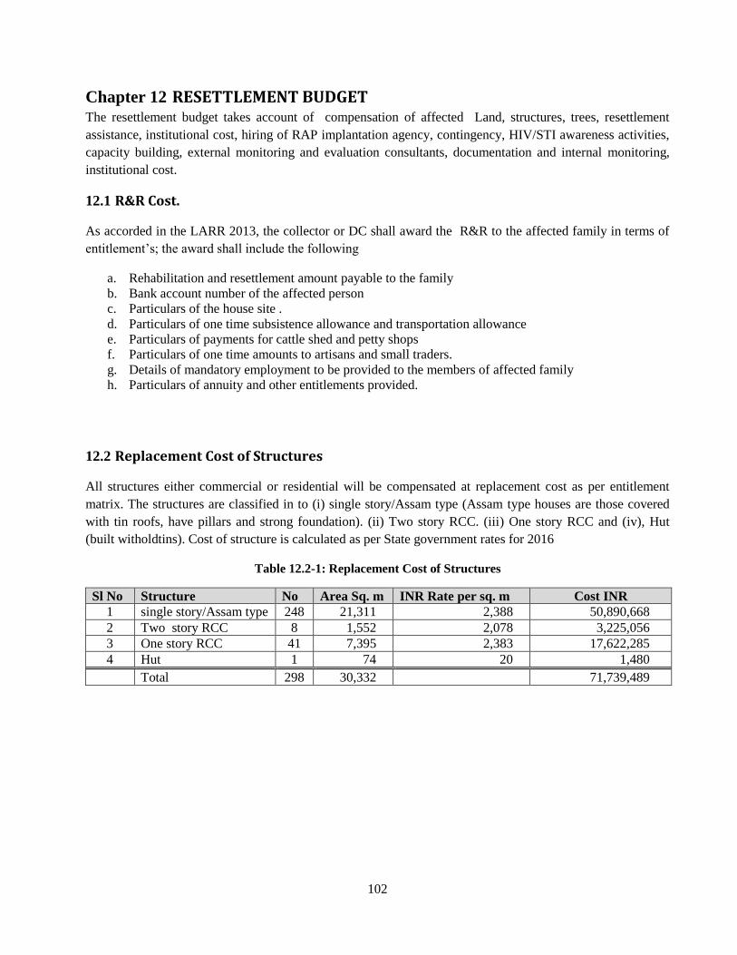
102
RESETTLEMENT BUDGET Chapter 12
The resettlement budget takes account of compensation of affected Land, structures, trees, resettlement
assistance, institutional cost, hiring of RAP implantation agency, contingency, HIV/STI awareness activities,
capacity building, external monitoring and evaluation consultants, documentation and internal monitoring,
institutional cost.
R&R Cost. 12.1
As accorded in the LARR 2013, the collector or DC shall award the R&R to the affected family in terms of
entitlement’s; the award shall include the following
a. Rehabilitation and resettlement amount payable to the family
b. Bank account number of the affected person
c. Particulars of the house site .
d. Particulars of one time subsistence allowance and transportation allowance
e. Particulars of payments for cattle shed and petty shops
f. Particulars of one time amounts to artisans and small traders.
g. Details of mandatory employment to be provided to the members of affected family
h. Particulars of annuity and other entitlements provided.
Replacement Cost of Structures 12.2
All structures either commercial or residential will be compensated at replacement cost as per entitlement
matrix. The structures are classified in to (i) single story/Assam type (Assam type houses are those covered
with tin roofs, have pillars and strong foundation). (ii) Two story RCC. (iii) One story RCC and (iv), Hut
(built witholdtins). Cost of structure is calculated as per State government rates for 2016
Table 12.2-1: Replacement Cost of Structures
Sl No Structure No Area Sq. m INR Rate per sq. m Cost INR
1 single story/Assam type 248 21,311 2,388 50,890,668
2 Two story RCC 8 1,552 2,078 3,225,056
3 One story RCC 41 7,395 2,383 17,622,285
4 Hut 1 74 20 1,480
Total 298 30,332 71,739,489
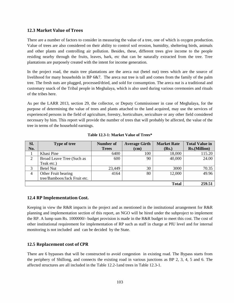
103
Market Value of Trees 12.3
There are a number of factors to consider in measuring the value of a tree, one of which is oxygen production.
Value of trees are also considered on their ability to control soil erosion, humidity, sheltering birds, animals
and other plants and controlling air pollution. Besides, these, different trees give income to the people
residing nearby through the fruits, leaves, bark, etc that can be naturally extracted from the tree. Tree
plantations are purposely created with the intent for income generation.
In the project road, the main tree plantations are the areca nut (betel nut) trees which are the source of
livelihood for many households in BP 6&7. The areca nut tree is tall and comes from the family of the palm
tree. The fresh nuts are plugged, processed/dried, and sold for consumption. The areca nut is a traditional and
customary snack of the Tribal people in Meghalaya, which is also used during various ceremonies and rituals
of the tribes here.
As per the LARR 2013, section 29, the collector, or Deputy Commissioner in case of Meghalaya, for the
purpose of determining the value of trees and plants attached to the land acquired, may use the services of
experienced persons in the field of agriculture, forestry, horticulture, sericulture or any other field considered
necessary by him. This report will provide the number of trees that will probably be affected, the value of the
tree in terms of the household earnings.
Table 12.3-1: Market Value of Trees*
Sl.
No.
Type of tree Number of
Trees
Average Girth
(cm)
Market Rate
(Rs.)
Total Value in
Rs.(Million)
1 Khasi Pine 6400 100 18,000 115.20
2 Broad Leave Tree (Such as
Teak etc.)
600 90 40,000 24.00
3 Betel Nut 23,449 30 3000 70.35
4 Other Fruit bearing
tree/Bamboos/Jack Fruit etc.
4164 80 12,000 49.96
Total 259.51
RP Implementation Cost. 12.4
Keeping in view the R&R impacts in the project and as mentioned in the institutional arrangement for R&R
planning and implementation section of this report, an NGO will be hired under the subproject to implement
the RP. A lump sum Rs. 1000000/- budget provision is made in the R&R budget to meet this cost. The cost of
other institutional requirement for implementation of RP such as staff in charge at PIU level and for internal
monitoring is not included and can be decided by the State.
Replacement cost of CPR 12.5
There are 6 bypasses that will be constructed to avoid congestion in existing road. The Bypass starts from
the periphery of Shillong, and connects the existing road in various junctions as BP 2, 3, 4, 5 and 6. The
affected structures are all included in the Table 12.2-1and trees in Table 12.3-1.
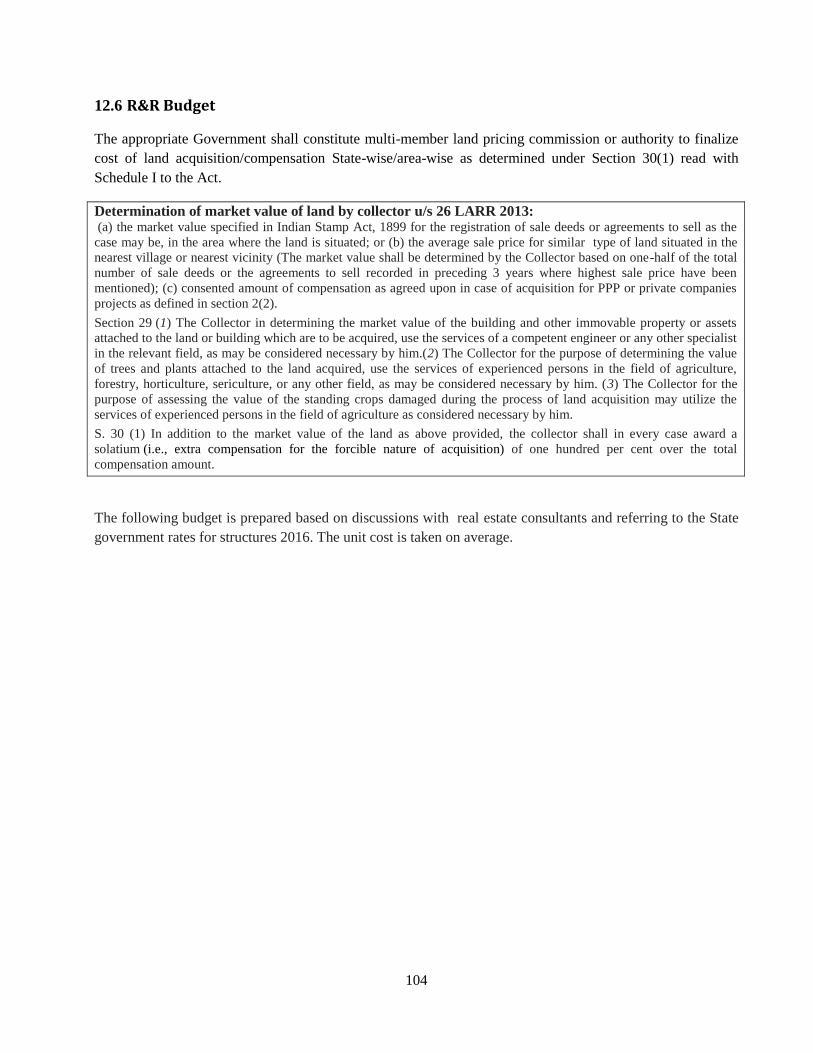
104
R&R Budget 12.6
The appropriate Government shall constitute multi-member land pricing commission or authority to finalize
cost of land acquisition/compensation State-wise/area-wise as determined under Section 30(1) read with
Schedule I to the Act.
Determination of market value of land by collector u/s 26 LARR 2013: (a) the market value specified in Indian Stamp Act, 1899 for the registration of sale deeds or agreements to sell as the
case may be, in the area where the land is situated; or (b) the average sale price for similar type of land situated in the
nearest village or nearest vicinity (The market value shall be determined by the Collector based on one-half of the total
number of sale deeds or the agreements to sell recorded in preceding 3 years where highest sale price have been
mentioned); (c) consented amount of compensation as agreed upon in case of acquisition for PPP or private companies
projects as defined in section 2(2).
Section 29 (1) The Collector in determining the market value of the building and other immovable property or assets
attached to the land or building which are to be acquired, use the services of a competent engineer or any other specialist
in the relevant field, as may be considered necessary by him.(2) The Collector for the purpose of determining the value
of trees and plants attached to the land acquired, use the services of experienced persons in the field of agriculture,
forestry, horticulture, sericulture, or any other field, as may be considered necessary by him. (3) The Collector for the
purpose of assessing the value of the standing crops damaged during the process of land acquisition may utilize the
services of experienced persons in the field of agriculture as considered necessary by him.
S. 30 (1) In addition to the market value of the land as above provided, the collector shall in every case award a
solatium (i.e., extra compensation for the forcible nature of acquisition) of one hundred per cent over the total
compensation amount.
The following budget is prepared based on discussions with real estate consultants and referring to the State
government rates for structures 2016. The unit cost is taken on average.
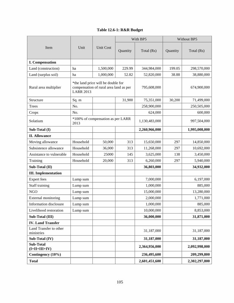
105
Table 12.6-1: R&R Budget
Item Unit Unit Cost
With BP5 Without BP5
Quantity Total (Rs) Quantity Total (Rs)
I. Compensation
Land (construction) ha 1,500,000 229.99 344,984,000 199.05 298,570,000
Land (surplus soil) ha 1,000,000 52.82 52,820,000 38.88 38,880,000
Rural area multiplier
*the land price will be double for
compensation of rural area land as per
LARR 2013
795,608,000
674,900,000
Structure Sq. m
31,900 75,351,000 30,200 71,499,000
Trees No.
258,900,000
250,505,000
Crops No.
624,000
600,000
Solatium *100% of compensation as per LARR
2013 1,130,483,000
997,504,000
Sub-Total (I)
2,260,966,000
1,995,008,000
II. Allowance
Moving allowance Household 50,000 313 15,650,000 297 14,850,000
Subsistence allowance Household 36,000 313 11,268,000 297 10,692,000
Assistance to vulnerable Household 25000 145 3,625,000 138 3,450,000
Training Household 20,000 313 6,260,000 297 5,940,000
Sub-Total (II)
36,803,000
34,932,000
III. Implementation
Expert fees Lump sum
7,000,000
6,197,000
Staff training Lump sum
1,000,000
885,000
NGO Lump sum
15,000,000
13,280,000
External monitoring Lump sum
2,000,000
1,771,000
Information disclosure Lump sum
1,000,000
885,000
Livelihood restoration Lump sum
10,000,000
8,853,000
Sub-Total (III)
36,000,000
31,871,000
IV. Land Transfer
Land Transfer to other
ministries 31,187,000
31,187,000
Sub-Total (IV)
31,187,000
31,187,000
Sub-Total
(I+II+III+IV) 2,364,956,000
2,092,998,000
Contingency (10%)
236,495,600
209,299,800
Total
2,601,451,600
2,302,297,800
106
RESETTLEMENT SCHEDULE Chapter 13
Introduction 13.1
The schedule is provisional, uncertain climatic conditions of the project area must be considered. A major
part of the project area is known for heavy rains, fog and mist that surface randomly at any time , making
driving and walking unsafe. Desk reviews, planning meetings and other documentation work can be done
during such times and the project should be aware and prepared of sudden weather change and adapt
strategies that will minimize loss of working hours.
Schedule for project implementation 13.2
Implementation of RAP mainly consists of compensation to be paid for land, affected structures;
Rehabilitation and Resettlement activities. The civil works contract for each sub-project will be awarded
when compensations are disbursed to entitled persons and minimum 80% of the land taken over by the
Government. Completion schedule will involve continuous coordination among the project management units
and the various other involved departments and agencies.
Schedule for Resettlement Action Plan 13.3
Consensus from concerned residents or agencies is planning to be obtained as following schedules.
As for 101 Area of Widening section 1, NHIDCL needs to obtain an official letter from MoD for
certifying their “No Objection” against land transfer.
As for Aire Force Area of Widening section 2, NHIDCL needs to obtain an official letter from Eastern Air
Command for certifying their “No Objection” against land transfer.
As for Bypass 2, DPR consultants has already prepared realignment considering objection against the
proposed alignment from local residents. NHIDCL reached agreement with concerned local residents
regarding the re-aligned route through public consultation meetings on 19 May, 2017.
As for Bypass 6&7, NHIDCL reached agreement with concerned local residents for the proposed
alignment and relocation of the PHC through public consultation meetings in coordination with the
Deputy Commissioner of West Jaintia Hills District and conducted Joint Inspection on 20th May, 2017.
NHIDCL needs to reach agreement with Border Security Force (BSF) under Ministry of Home Affairs
regarding the proposed alignment as well.
R&R Implementation Schedule 13.4
The R& R implementation schedule is as follows
The R& R implementation schedule will follow the below key activity4:
4 Refer to LARR 2013 chapter ii (B),chapter iv Chapter vi,
107
i. State Government shall by notification appoint in respect of the project, an Officer not below the
rank of joint Collector or Additional Collector or Deputy Collector or equivalent Official of Revenue
Department to be the Administrator for Rehabilitation and Resettlement.
ii. The Administrator for R&R , with a view to enable him to function efficiently , will be provided
with such powers, duties and responsibilities as prescribed by the appropriate Government ;and also
be provided with Office infrastructure and be assisted by Officers and staff who shall be subordinate
to him as the appropriate Government may decide.
iii. The State Government shall also appoint an Officer of the rank of Commissioner or secretary for
R&R who will be responsible for supervising the formulation of R&R schemes or plans and the
proper implementation of the same. He/She will also be responsible for the post –implementation
social Audit.
iv. Under the Chairmanship of the Administrator of R&R, the State Government shall constitute a
Committee called the Rehabilitation and Resettlement Committee. The members of such a committee
may consist as provided by the LARR 2013 section vi clause 45 (2).
v. A notification to the effect of the project affected land will be published in the Official gazette, two
daily newspapers, of which one is of the regional language, in the respective village Dorbar Office,
the office of the District Collector and the Sub divisional magistrate; uploaded in the Official
website of the government and in the affected villages.
vi. Immediately after issuance of the notification , the Autonomous Disrict councils shall be informed of
the notification issued at a meeting called especially for the purpose.
vii. Appraisal of Social Impact Assessment Report by Expert Group. The appropriate government will
ensure that the Social Impact assessment be evaluated by an expert group (consisting of members as
prescribed in the LARR 2013 chapter II Clause 7 (2).
viii. Update the list of PAP through Detailed Measurement Survey DMC.
ix. Conduct a survey and undertake census of the affected families- Inventory of affected properties
and assets estimation.
Phase of Resettlement and Rehabilitation To summarize, the proposed R&R activities are divided in to three broad categories based on the stages of
work and process of implementation. The details of activities involved in these three phases, i.e. Project
Preparation Phase, RP Implementation phase, Monitoring and Evaluation period :
(a).Project Preparation Phase
The major activities to be performed in this period include establishment of PMU and PIU at project
and level .
108
Appointment of NGO and establishment of GRC etc.
The information campaign & community consultation will be a process initiated from this stage and
will go on till the end of the project. Information dissemination through consultations, community
meetings using brochures/leaflets that inform about the resettlement policy, entitlements and any
necessary information deem fit for the project effectiveness. The language of the dissemination must
be in the regional language.
(b). RP Implementation Phase
After the project preparation phase the next stage is implementation of RP which includes issue
compensation of award by EA; payment of all eligible assistance; relocation of PAPs; initiation of
economic rehabilitation measures; site preparation for delivering the site to contractors for
construction and finally starting civil work.
(c). Monitoring and Evaluation Period
As mentioned earlier the internal monitoring will be the responsibility of PMU, PIU and
implementing NGO and will start early during the project when implementation of RP starts and will
continue till the complementation of the project. The independent monitoring and evaluation will be
the responsibility of an external agency to be hired for the Project.
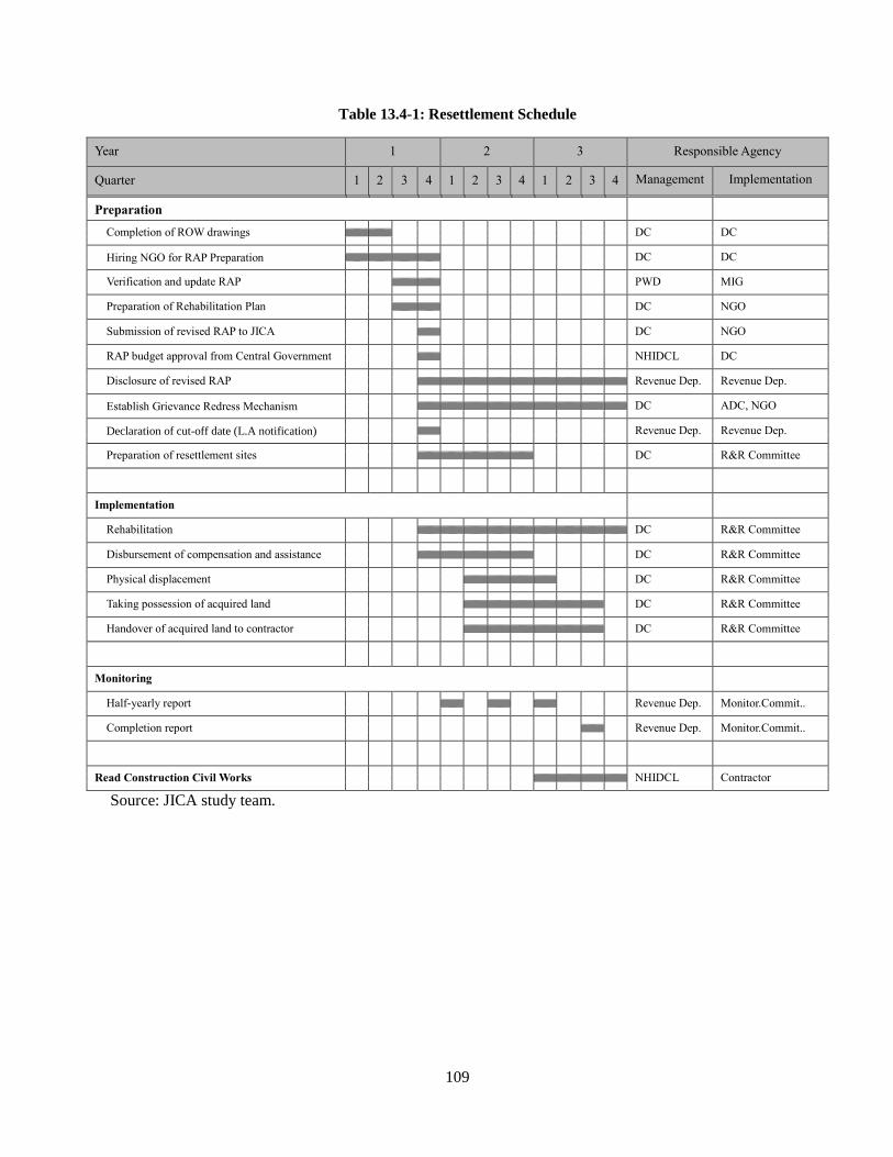
109
Table 13.4-1: Resettlement Schedule
Year 1 2 3 Responsible Agency
Quarter 1 2 3 4 1 2 3 4 1 2 3 4 Management
Implementation
Preparation
Completion of ROW drawings DC DC
Hiring NGO for RAP Preparation DC DC
Verification and update RAP PWD MIG
Preparation of Rehabilitation Plan DC NGO
Submission of revised RAP to JICA DC NGO
RAP budget approval from Central Government NHIDCL DC
Disclosure of revised RAP Revenue Dep. Revenue Dep.
Establish Grievance Redress Mechanism DC ADC, NGO
Declaration of cut-off date (L.A notification) Revenue Dep. Revenue Dep.
Preparation of resettlement sites DC R&R Committee
Implementation
Rehabilitation DC R&R Committee
Disbursement of compensation and assistance DC R&R Committee
Physical displacement DC R&R Committee
Taking possession of acquired land DC R&R Committee
Handover of acquired land to contractor DC R&R Committee
Monitoring
Half-yearly report Revenue Dep. Monitor.Commit..
Completion report Revenue Dep. Monitor.Commit..
Read Construction Civil Works NHIDCL Contractor
Source: JICA study team.

Appendices
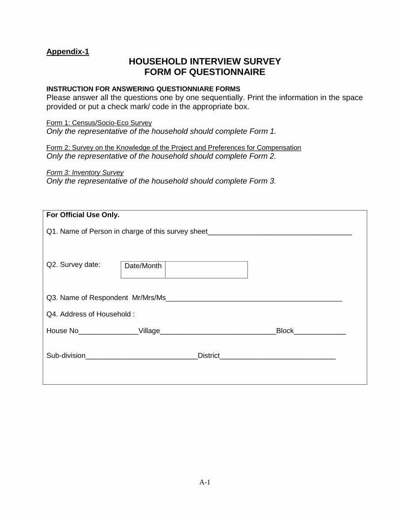
A-1
Appendix-1
HOUSEHOLD INTERVIEW SURVEY FORM OF QUESTIONNAIRE
INSTRUCTION FOR ANSWERING QUESTIONNIARE FORMS
Please answer all the questions one by one sequentially. Print the information in the space provided or put a check mark/ code in the appropriate box. Form 1: Census/Socio-Eco Survey
Only the representative of the household should complete Form 1. Form 2: Survey on the Knowledge of the Project and Preferences for Compensation
Only the representative of the household should complete Form 2. Form 3: Inventory Survey
Only the representative of the household should complete Form 3.
For Official Use Only. Q1. Name of Person in charge of this survey sheet____________________________________ Q2. Survey date: Q3. Name of Respondent Mr/Mrs/Ms____________________________________________ Q4. Address of Household : House No_______________Village_____________________________Block_____________ Sub-division____________________________District_____________________________
Date/Month
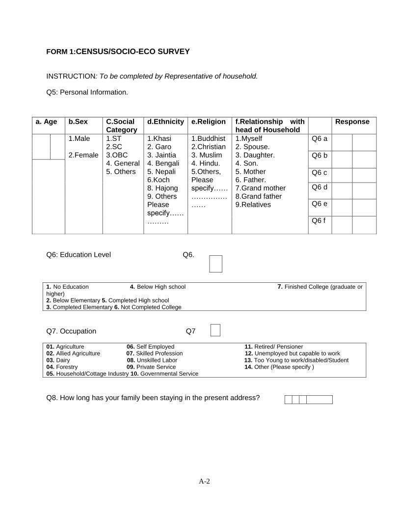
A-2
FORM 1:CENSUS/SOCIO-ECO SURVEY
INSTRUCTION: To be completed by Representative of household.
Q5: Personal Information.
Q6: Education Level Q6.
1. No Education 4. Below High school 7. Finished College (graduate or
higher) 2. Below Elementary 5. Completed High school 3. Completed Elementary 6. Not Completed College
Q7. Occupation Q7
01. Agriculture 06. Self Employed 11. Retired/ Pensioner 02. Allied Agriculture 07. Skilled Profession 12. Unemployed but capable to work 03. Dairy 08. Unskilled Labor 13. Too Young to work/disabled/Student 04. Forestry 09. Private Service 14. Other (Please specify ) 05. Household/Cottage Industry 10. Governmental Service
Q8. How long has your family been staying in the present address?
a. Age b.Sex C.Social Category
d.Ethnicity e.Religion f.Relationship with head of Household
Response
1.Male 2.Female
1.ST 2.SC 3.OBC 4. General 5. Others
1.Khasi 2. Garo 3. Jaintia 4. Bengali 5. Nepali 6.Koch 8. Hajong 9. Others Please specify……………
1.Buddhist 2.Christian 3. Muslim 4. Hindu. 5.Others, Please specify………………………
1.Myself 2. Spouse. 3. Daughter. 4. Son. 5. Mother 6. Father. 7.Grand mother 8.Grand father 9.Relatives
Q6 a
Q6 b
Q6 c
Q6 d
Q6 e
Q6 f
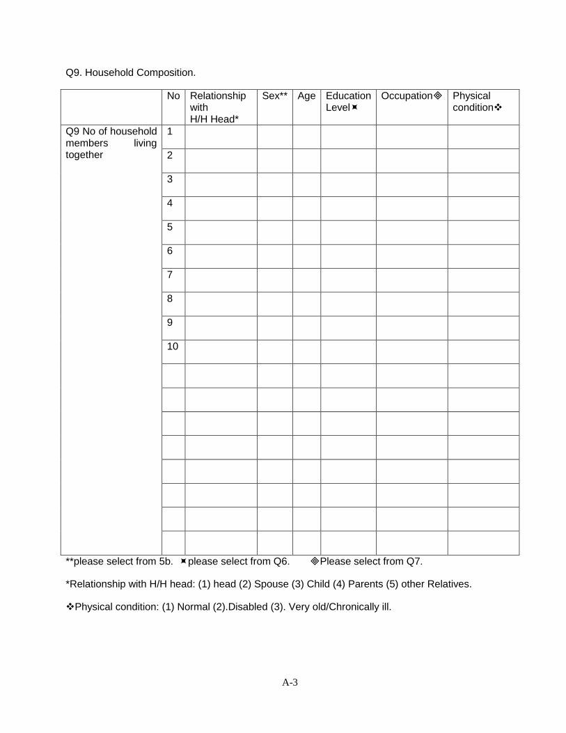
A-3
Q9. Household Composition.
No Relationship with H/H Head*
Sex** Age Education Level
Occupation Physical condition
Q9 No of household members living together
1
2
3
4
5
6
7
8
9
10
**please select from 5b. please select from Q6. Please select from Q7.
*Relationship with H/H head: (1) head (2) Spouse (3) Child (4) Parents (5) other Relatives.
Physical condition: (1) Normal (2).Disabled (3). Very old/Chronically ill.
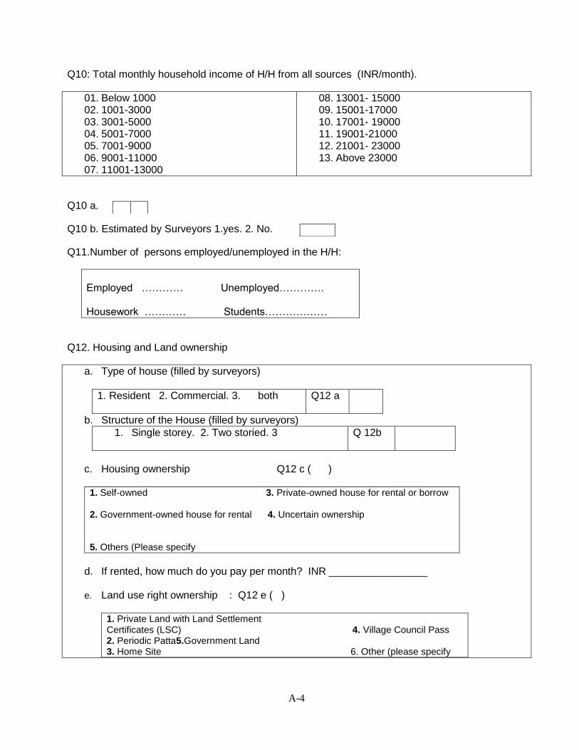
A-4
Q10: Total monthly household income of H/H from all sources (INR/month).
01. Below 1000 02. 1001-3000 03. 3001-5000 04. 5001-7000 05. 7001-9000 06. 9001-11000 07. 11001-13000
08. 13001- 15000 09. 15001-17000 10. 17001- 19000 11. 19001-21000 12. 21001- 23000 13. Above 23000
Q10 a.
Q10 b. Estimated by Surveyors 1.yes. 2. No.
Q11.Number of persons employed/unemployed in the H/H:
Employed ………… Unemployed…………. Housework ………… Students………………
Q12. Housing and Land ownership
a. Type of house (filled by surveyors)
1. Resident 2. Commercial. 3. both
Q12 a
b. Structure of the House (filled by surveyors)
1. Single storey. 2. Two storied. 3 Q 12b
c. Housing ownership Q12 c ( )
1. Self-owned 3. Private-owned house for rental or borrow 2. Government-owned house for rental 4. Uncertain ownership 5. Others (Please specify
d. If rented, how much do you pay per month? INR _________________
e. Land use right ownership : Q12 e ( )
1. Private Land with Land Settlement Certificates (LSC) 4. Village Council Pass 2. Periodic Patta5.Government Land 3. Home Site 6. Other (please specify
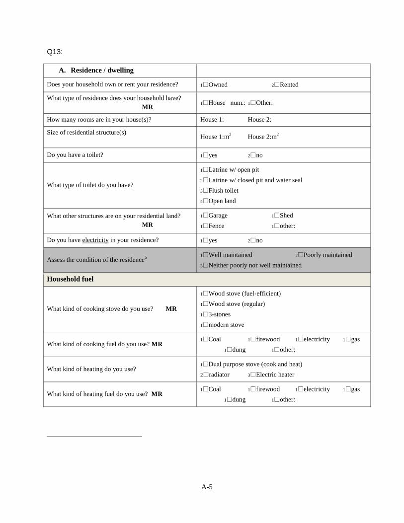
A-5
Q13:
A. Residence / dwelling
Does your household own or rent your residence? 1Owned 2Rented
What type of residence does your household have?
MR 1House num.: 1Other:
How many rooms are in your house(s)? House 1: House 2:
Size of residential structure(s)
House 1: m
2 House 2: m
2
Do you have a toilet? 1yes 2no
What type of toilet do you have?
1Latrine w/ open pit
2Latrine w/ closed pit and water seal
3Flush toilet
4Open land
What other structures are on your residential land?
MR
1Garage 1Shed
1Fence 1other:
Do you have electricity in your residence? 1yes 2no
Assess the condition of the residence5
1Well maintained 2Poorly maintained
3Neither poorly nor well maintained
Household fuel
What kind of cooking stove do you use? MR
1Wood stove (fuel-efficient)
1Wood stove (regular)
13-stones
1modern stove
What kind of cooking fuel do you use? MR 1Coal 1firewood 1electricity 1gas
1dung 1other:
What kind of heating do you use? 1Dual purpose stove (cook and heat)
2radiator 3Electric heater
What kind of heating fuel do you use? MR 1Coal 1firewood 1electricity 1gas
1dung 1other:
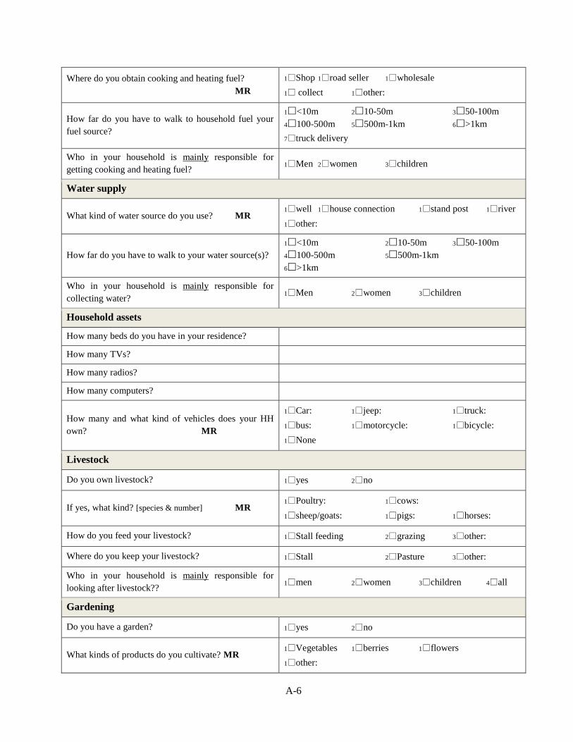
A-6
Where do you obtain cooking and heating fuel?
MR
1Shop 1road seller 1wholesale
1 collect 1other:
How far do you have to walk to household fuel your
fuel source?
1<10m 210-50m 350-100m
4100-500m 5500m-1km 6>1km
7truck delivery
Who in your household is mainly responsible for
getting cooking and heating fuel? 1Men 2women 3children
Water supply
What kind of water source do you use? MR 1well 1house connection 1stand post 1river
1other:
How far do you have to walk to your water source(s)?
1<10m 210-50m 350-100m
4100-500m 5500m-1km
6>1km
Who in your household is mainly responsible for
collecting water? 1Men 2women 3children
Household assets
How many beds do you have in your residence?
How many TVs?
How many radios?
How many computers?
How many and what kind of vehicles does your HH
own? MR
1Car: 1jeep: 1truck:
1bus: 1motorcycle: 1bicycle:
1None
Livestock
Do you own livestock? 1yes 2no
If yes, what kind? [species & number] MR 1Poultry: 1cows:
1sheep/goats: 1pigs: 1horses:
How do you feed your livestock? 1Stall feeding 2grazing 3other:
Where do you keep your livestock? 1Stall 2Pasture 3other:
Who in your household is mainly responsible for
looking after livestock?? 1men 2women 3children 4all
Gardening
Do you have a garden? 1yes 2no
What kinds of products do you cultivate? MR 1Vegetables 1berries 1flowers
1other:

A-7
Who in your household is mainly responsible for
cultivating your garden? 1Men 2women 3children 4all
Health and nutrition
What are the most common diseases your household
suffers from? MR
1 diarrhea 1 cold/flu
1heart disease 1jaundice
1 cancer 1 tuberculosis
1 leukemia 1joint pains
1 blood pressure
1 other:_____________________
Where do you seek medical help? MR
1Government hospitals
1Private hospitals
1Private doctor
1Traditional medical practitioner
1Shaman
1home remedies
1other:
How far is the health service you use? 1<1km 21-5km 3>5km
Do you have enough food for your household every
day? 1yes 2no
How many meals do you usually have per day? 11 22 33 44
Transport
How does your family travel to work and school?
MR
1walking 1bus 1bicycle
1motorcycle 1car
1other:
How long does it take?
Adults:
Children:
How much per month does it cost? INR:
Gender relations
What are primary tasks of women? 1Household work 2Earning income
3Other:
What are the primary tasks of men? 1Household work 2Earning income
3Other:
Who in your households makes decisions regarding
home related matters?
1Men 2women 3joint
4separately
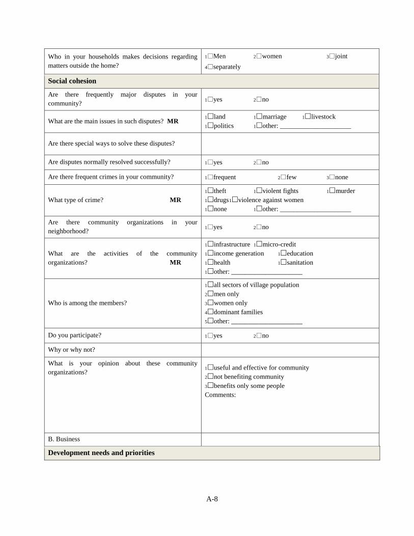
A-8
Who in your households makes decisions regarding
matters outside the home?
1Men 2women 3joint
4separately
Social cohesion
Are there frequently major disputes in your
community? 1yes 2no
What are the main issues in such disputes? MR 1land 1marriage 1livestock
1politics 1other: _____________________
Are there special ways to solve these disputes?
Are disputes normally resolved successfully? 1yes 2no
Are there frequent crimes in your community? 1frequent 2few 3none
What type of crime? MR
1theft 1violent fights 1murder
1drugs 1violence against women
1none 1other: _____________________
Are there community organizations in your
neighborhood? 1yes 2no
What are the activities of the community
organizations? MR
1infrastructure 1micro-credit
1income generation 1education
1health 1sanitation
1other: _____________________
Who is among the members?
1all sectors of village population
2men only
3women only
4dominant families
5other: _____________________
Do you participate? 1yes 2no
Why or why not?
What is your opinion about these community
organizations?
1useful and effective for community
2not benefiting community
3benefits only some people
Comments:
B. Business
Development needs and priorities
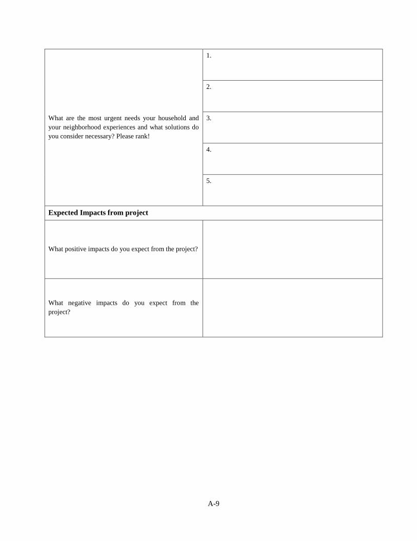
A-9
What are the most urgent needs your household and
your neighborhood experiences and what solutions do
you consider necessary? Please rank!
1.
2.
3.
4.
5.
Expected Impacts from project
What positive impacts do you expect from the project?
What negative impacts do you expect from the
project?
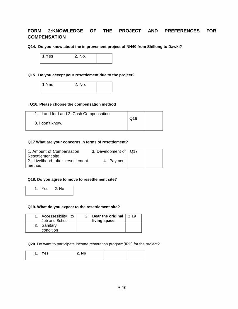
A-10
FORM 2:KNOWLEDGE OF THE PROJECT AND PREFERENCES FOR
COMPENSATION
Q14. Do you know about the improvement project of NH40 from Shillong to Dawki?
1.Yes 2. No.
Q15. Do you accept your resettlement due to the project?
1.Yes 2. No.
. Q16. Please choose the compensation method
1. Land for Land 2. Cash Compensation 3. I don’t know.
Q16
Q17 What are your concerns in terms of resettlement?
1. Amount of Compensation 3. Development of Resettlement site 2. Livelihood after resettlement 4. Payment method
Q17
Q18. Do you agree to move to resettlement site?
1. Yes 2. No
Q19. What do you expect to the resettlement site?
1. Accessesibility to Job and School
2. Bear the original living space.
Q 19
3. Sanitary condition
Q20. Do want to participate income restoration program(IRP) for the project?
1. Yes 2. No
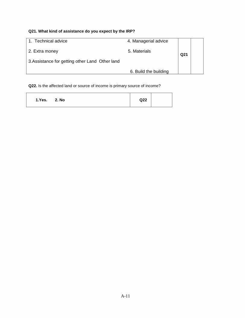
A-11
Q21. What kind of assistance do you expect by the IRP?
1. Technical advice 4. Managerial advice 2. Extra money 5. Materials 3.Assistance for getting other Land Other land 6. Build the building
Q21
Q22. Is the affected land or source of income is primary source of income?
1.Yes. 2. No
Q22
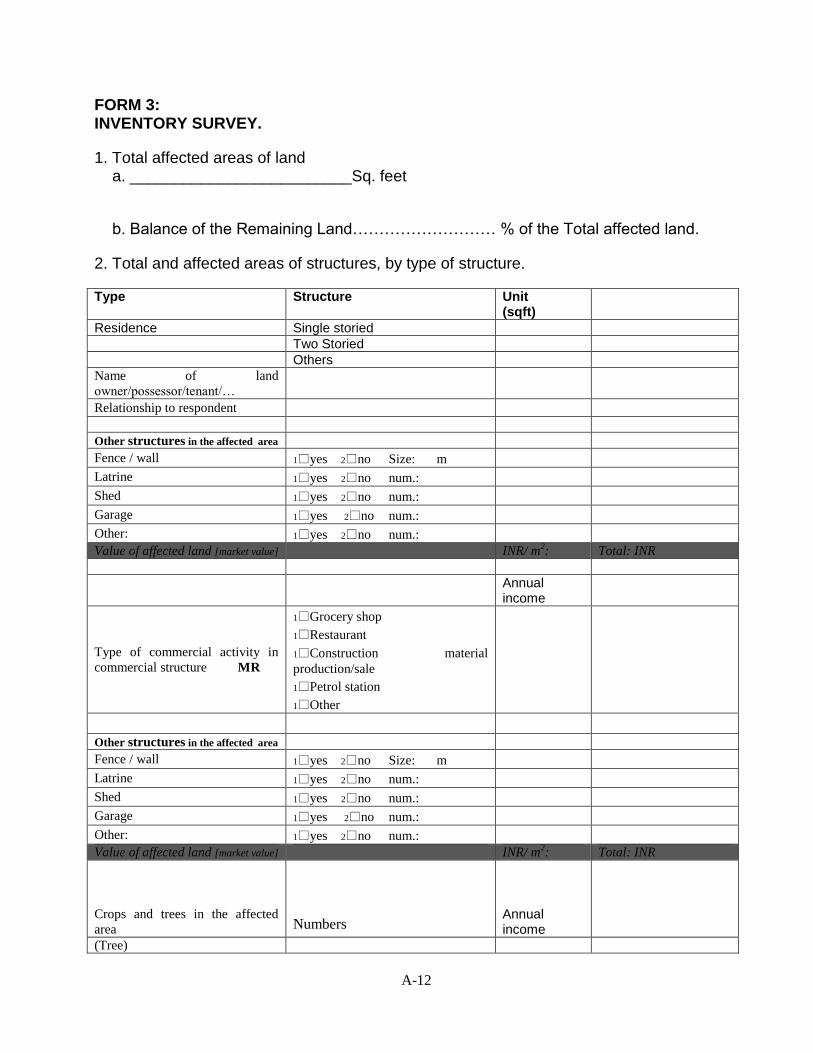
A-12
FORM 3: INVENTORY SURVEY.
1. Total affected areas of land a. _________________________Sq. feet
b. Balance of the Remaining Land……………………… % of the Total affected land.
2. Total and affected areas of structures, by type of structure.
Type Structure Unit (sqft)
Residence Single storied
Two Storied
Others
Name of land
owner/possessor/tenant/…
Relationship to respondent
Other structures in the affected area
Fence / wall 1yes 2no Size: m
Latrine 1yes 2no num.:
Shed 1yes 2no num.:
Garage 1yes 2no num.:
Other: 1yes 2no num.:
Value of affected land [market value] INR/ m2: Total: INR
Annual income
Type of commercial activity in
commercial structure MR
1Grocery shop
1Restaurant
1Construction material
production/sale
1Petrol station
1Other
Other structures in the affected area
Fence / wall 1yes 2no Size: m
Latrine 1yes 2no num.:
Shed 1yes 2no num.:
Garage 1yes 2no num.:
Other: 1yes 2no num.:
Value of affected land [market value] INR/ m2: Total: INR
Crops and trees in the affected
area
Numbers
Annual income
(Tree)
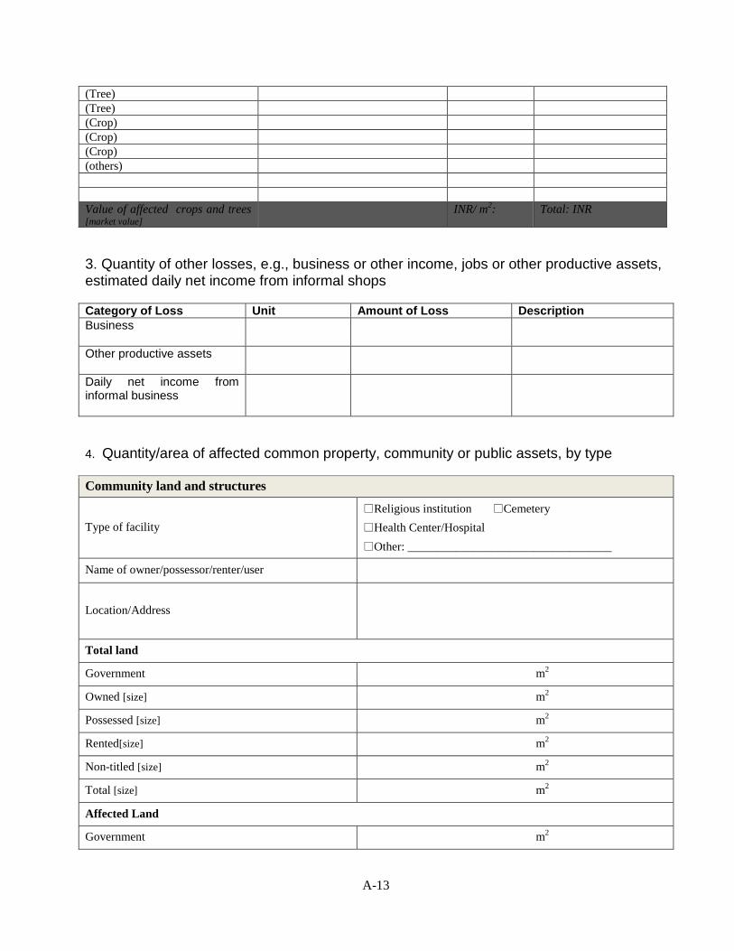
A-13
(Tree)
(Tree)
(Crop)
(Crop)
(Crop)
(others)
Value of affected crops and trees [market value]
INR/ m
2: Total: INR
3. Quantity of other losses, e.g., business or other income, jobs or other productive assets, estimated daily net income from informal shops
Category of Loss Unit Amount of Loss Description
Business
Other productive assets
Daily net income from informal business
4. Quantity/area of affected common property, community or public assets, by type
Community land and structures
Type of facility
Religious institution Cemetery
Health Center/Hospital
Other: __________________________________
Name of owner/possessor/renter/user
Location/Address
Total land
Government m2
Owned [size] m2
Possessed [size] m2
Rented[size] m2
Non-titled [size] m2
Total [size] m2
Affected Land
Government m2
A-14
Owned [size] m2
Possessed [size] m2
Rented[size] m2
Non-titled [size] m2
Total [size] m2
Value of affected land [market value] INR/ m2: Total: INR
Total Structures 1yes 2no
House 1yes 2no Size: m
Fence / wall 1yes 2no Size: m
Latrine 1yes 2no num.:
Shed 1yes 2no num.:
Garage 1yes 2no num.:
Other: 1yes 2no num.:
Affected structures 1yes 2no
House
1 num.: size: m2
Proportion of house affected: %
Can be rebuilt on land? 1yes 2no
Valueof affected structures
[market value] INR/ m
2: Total: INR
Fence / wall
1yes 2no
can be moved m from ROW
Size: m
Value of affected fence/wall [market value] INR/ m: Total: INR
Community Latrine 1yes 2no
Value of affected Latrine [market value] INR/ m2: Total: INR
Community Shed 1yes 2no
Value of affected Shed [market value] INR/ m2: Total: INR
Other 1yes 2no
Value of affected other structure
[market value] INR/ m
2: Total: INR
Cemetery
Need to move graves 1yes 2no
Num. to be moved Num.:

A-15
Comments
A-16
Appendix-2: Signature of the Attendees on Stakeholders Consultation
1st round consultation in Pynursla (Bypass 5) (10 June, 2016)
1st round consultation in Pynursla (north, Bypass 5) (9 July, 2016)
A-17
1st round consultation in Pynursla (south) (9 July, 2016)
A-18
1st round consultation in Pynursla (north, Bypass 5) (12 August, 2016)
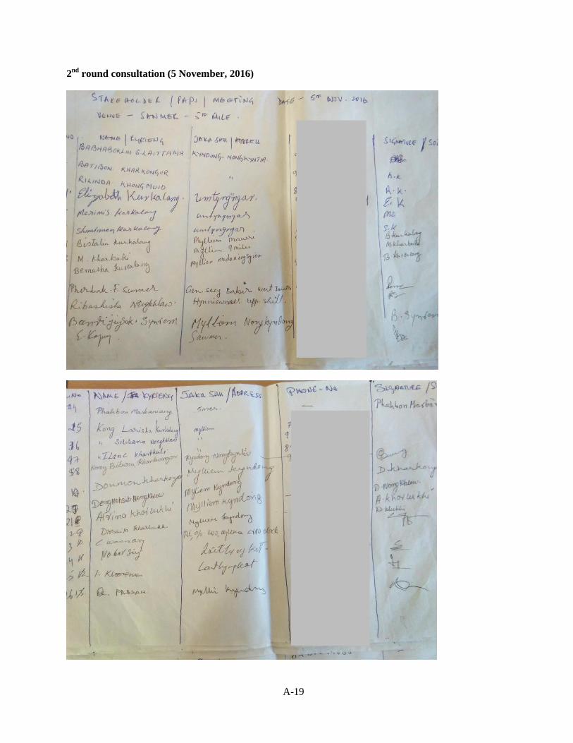
A-19
2nd
round consultation (5 November, 2016)
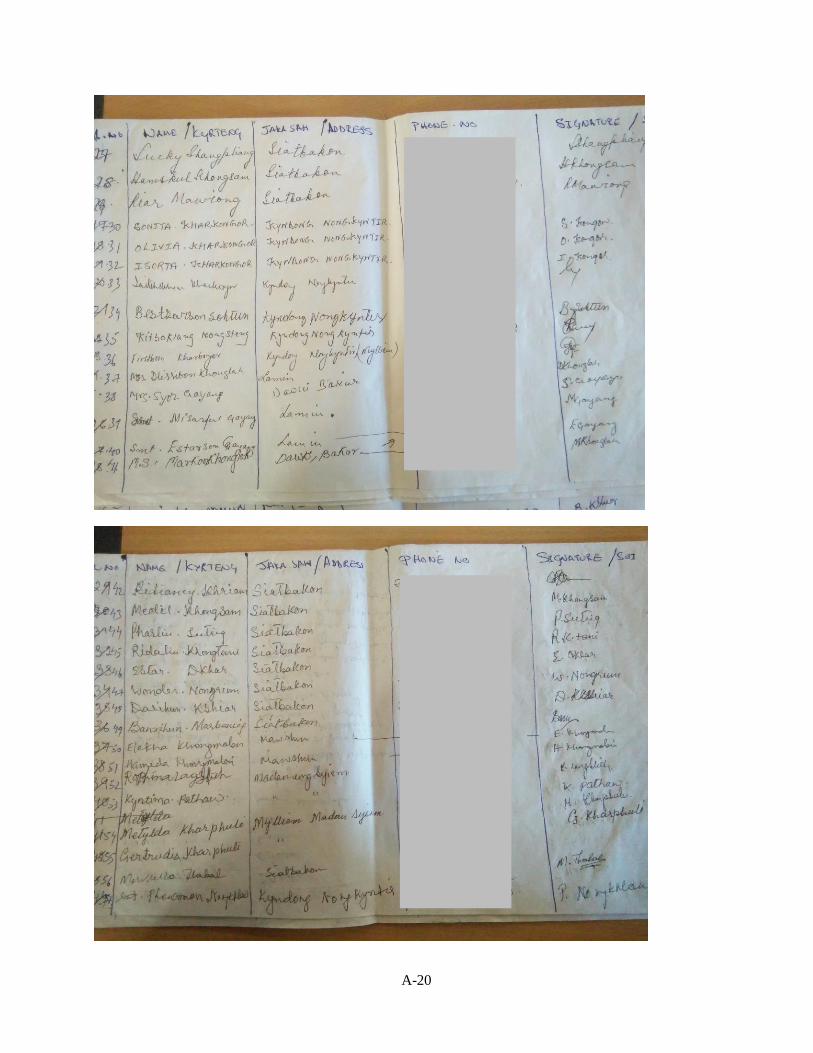
A-20
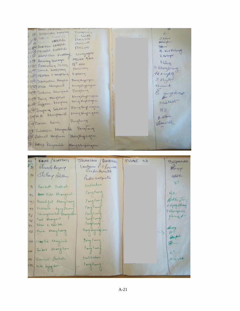
A-21
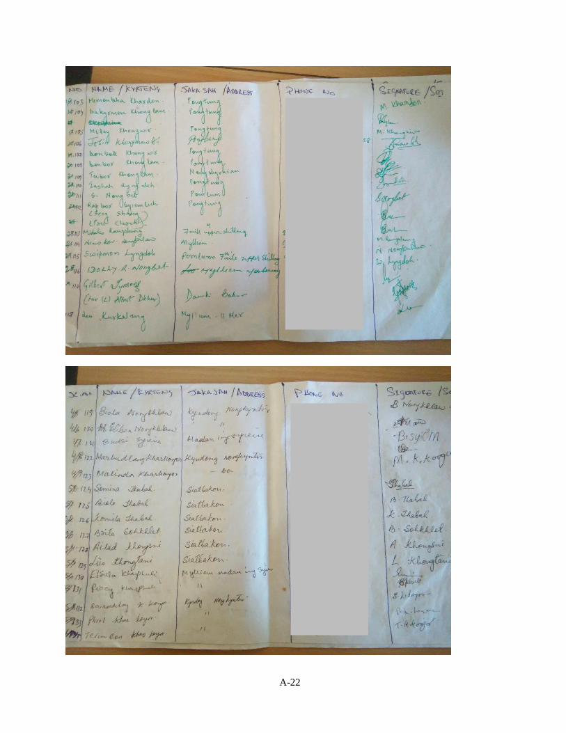
A-22
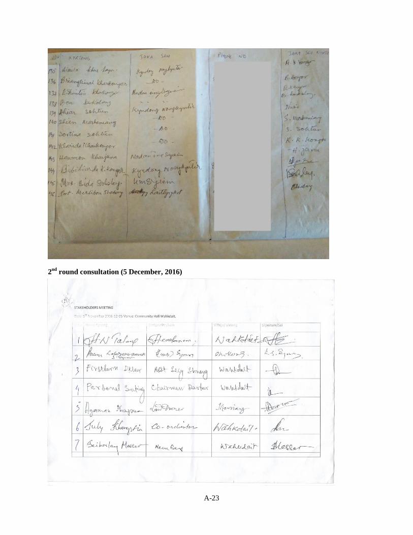
A-23
2nd
round consultation (5 December, 2016)
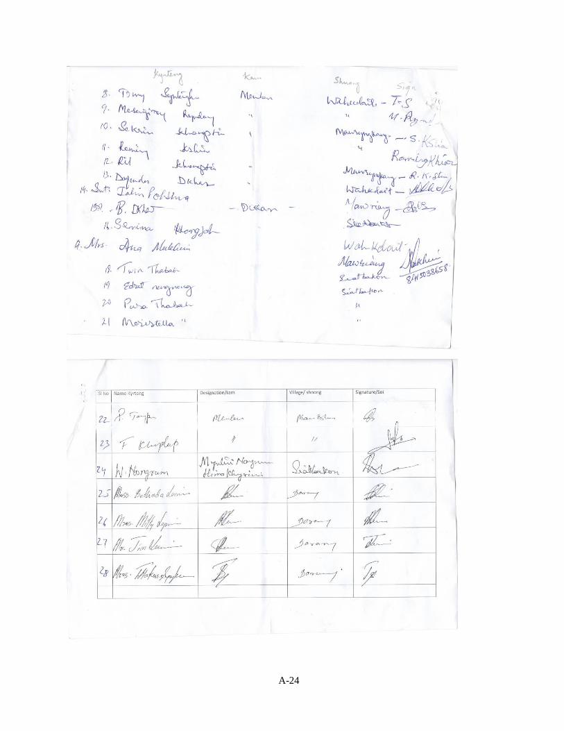
A-24
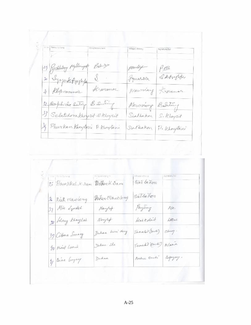
A-25
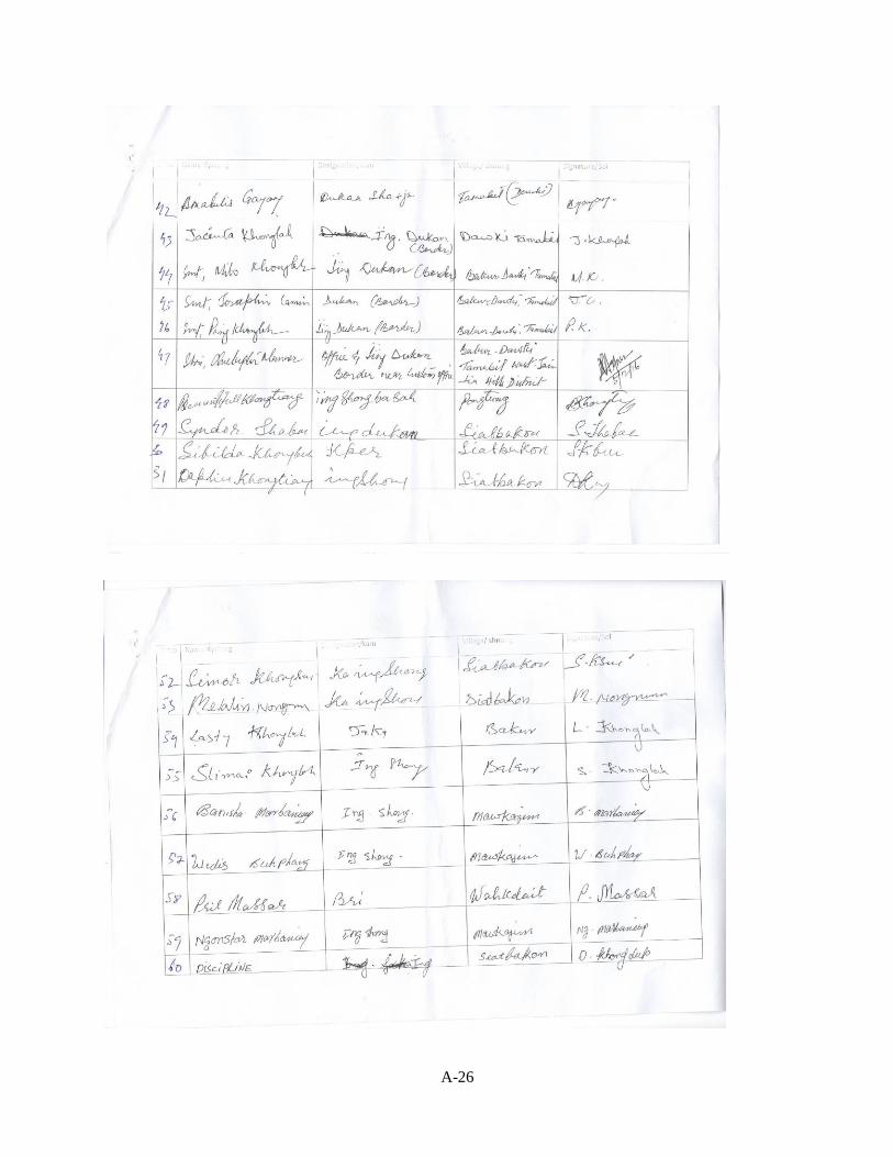
A-26
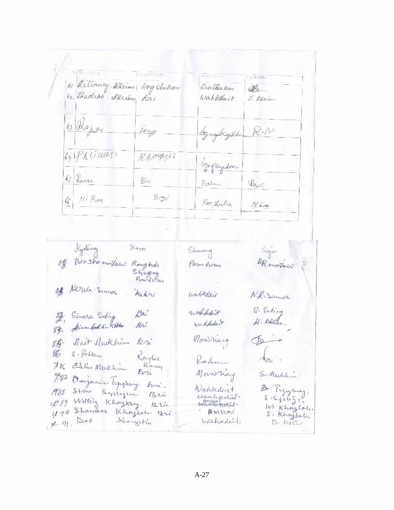
A-27
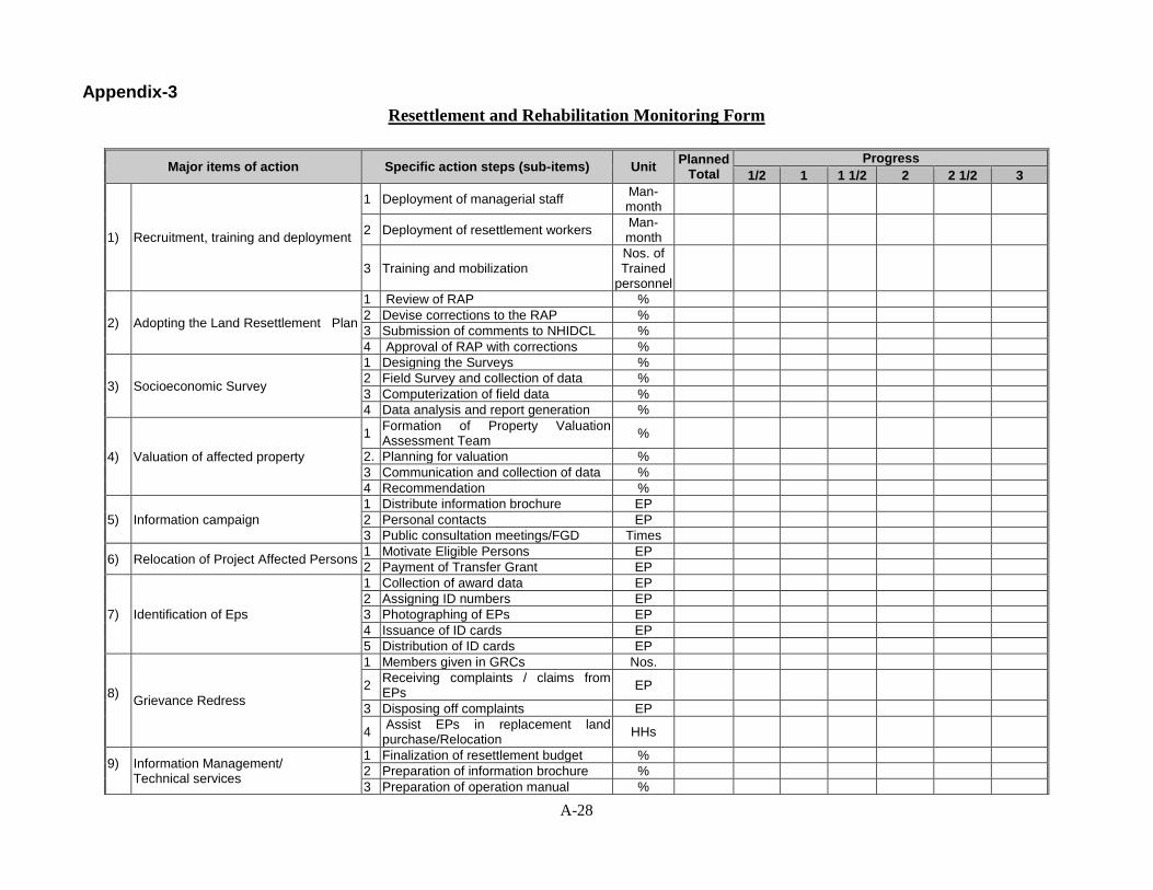
A-28
Appendix-3
Resettlement and Rehabilitation Monitoring Form
Major items of action Specific action steps (sub-items) Unit Planned
Total
Progress
1/2 1 1 1/2 2 2 1/2 3
1) Recruitment, training and deployment
1 Deployment of managerial staff Man-month
2 Deployment of resettlement workers Man-month
3 Training and mobilization Nos. of Trained
personnel
2) Adopting the Land Resettlement Plan
1 Review of RAP %
2 Devise corrections to the RAP %
3 Submission of comments to NHIDCL %
4 Approval of RAP with corrections %
3) Socioeconomic Survey
1 Designing the Surveys %
2 Field Survey and collection of data %
3 Computerization of field data %
4 Data analysis and report generation %
4) Valuation of affected property
1 Formation of Property Valuation Assessment Team
%
2. Planning for valuation %
3 Communication and collection of data %
4 Recommendation %
5) Information campaign
1 Distribute information brochure EP
2 Personal contacts EP
3 Public consultation meetings/FGD Times
6) Relocation of Project Affected Persons 1 Motivate Eligible Persons EP
2 Payment of Transfer Grant EP
7) Identification of Eps
1 Collection of award data EP
2 Assigning ID numbers EP
3 Photographing of EPs EP
4 Issuance of ID cards EP
5 Distribution of ID cards EP
8)
Grievance Redress
1 Members given in GRCs Nos.
2 Receiving complaints / claims from EPs
EP
3 Disposing off complaints EP
4 Assist EPs in replacement land purchase/Relocation
HHs
9)
Information Management/ Technical services
1 Finalization of resettlement budget %
2 Preparation of information brochure %
3 Preparation of operation manual %
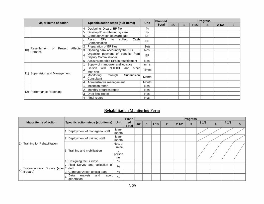
A-29
Major items of action Specific action steps (sub-items) Unit Planned
Total
Progress
1/2 1 1 1/2 2 2 1/2 3
4 Designing ID card, EP file %
5 Develop ID numbering system %
6 Computerization of award data EP
10) Resettlement of Project Affected Persons.
1 Assist EPs to collect Cash Compensation
EP
2 Preparation of EP files Sets
3 Opening bank account by the EPs Nos.
4 Organize payment of benefits from Deputy Commissioner
EP
5 Assist vulnerable EPs in resettlement Nos.
11) Supervision and Management
1 Supply of manpower and logistics mms
2 Liaison with NHIDCL and other agencies
Times
3 Monitoring through Supervision Consultant
Month
4 Administrative management Month
12) Performance Reporting
1 Inception report Nos.
2 Monthly progress report Nos.
3 Draft final report Nos.
4 Final report Nos.
Rehabilitation Monitoring Form
Major items of action Specific action steps (sub-items) Unit Plann
ed Total
Progress
1/2 1 1 1/2 2 2 1/2 3 3 1/2
4 4 1/2
5
1) Training for Rehabilitation
1 Deployment of managerial staff Man-month
2 Deployment of training staff Man-month
3 Training and mobilization
Nos. of Traine
d person
nel
2) Socioeconomic Survey (after 5 years)
1 Designing the Surveys %
2 Field Survey and collection of data
%
3 Computerization of field data %
4 Data analysis and report generation
%
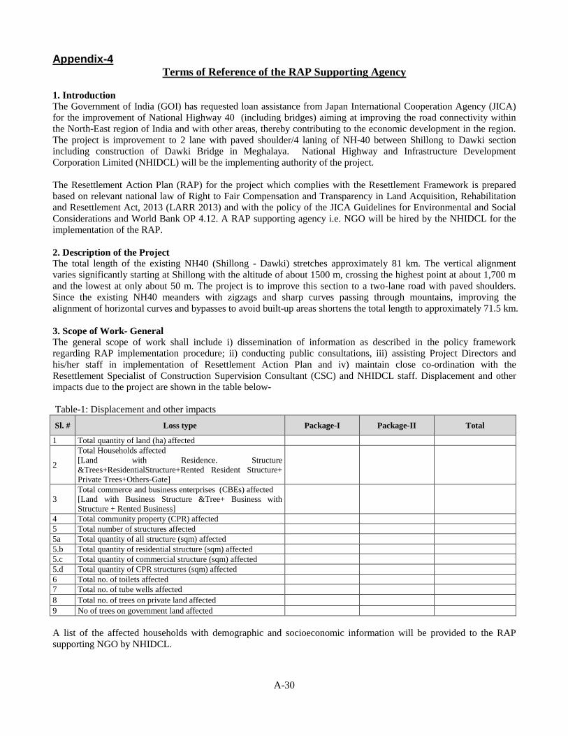
A-30
Appendix-4 Terms of Reference of the RAP Supporting Agency
1. Introduction
The Government of India (GOI) has requested loan assistance from Japan International Cooperation Agency (JICA)
for the improvement of National Highway 40 (including bridges) aiming at improving the road connectivity within
the North-East region of India and with other areas, thereby contributing to the economic development in the region.
The project is improvement to 2 lane with paved shoulder/4 laning of NH-40 between Shillong to Dawki section
including construction of Dawki Bridge in Meghalaya. National Highway and Infrastructure Development
Corporation Limited (NHIDCL) will be the implementing authority of the project.
The Resettlement Action Plan (RAP) for the project which complies with the Resettlement Framework is prepared
based on relevant national law of Right to Fair Compensation and Transparency in Land Acquisition, Rehabilitation
and Resettlement Act, 2013 (LARR 2013) and with the policy of the JICA Guidelines for Environmental and Social
Considerations and World Bank OP 4.12. A RAP supporting agency i.e. NGO will be hired by the NHIDCL for the
implementation of the RAP.
2. Description of the Project The total length of the existing NH40 (Shillong - Dawki) stretches approximately 81 km. The vertical alignment
varies significantly starting at Shillong with the altitude of about 1500 m, crossing the highest point at about 1,700 m
and the lowest at only about 50 m. The project is to improve this section to a two-lane road with paved shoulders.
Since the existing NH40 meanders with zigzags and sharp curves passing through mountains, improving the
alignment of horizontal curves and bypasses to avoid built-up areas shortens the total length to approximately 71.5 km.
3. Scope of Work- General
The general scope of work shall include i) dissemination of information as described in the policy framework
regarding RAP implementation procedure; ii) conducting public consultations, iii) assisting Project Directors and
his/her staff in implementation of Resettlement Action Plan and iv) maintain close co-ordination with the
Resettlement Specialist of Construction Supervision Consultant (CSC) and NHIDCL staff. Displacement and other
impacts due to the project are shown in the table below-
Table-1: Displacement and other impacts
Sl. # Loss type Package-I Package-II Total
1 Total quantity of land (ha) affected
2
Total Households affected
[Land with Residence. Structure
&Trees+ResidentialStructure+Rented Resident Structure+
Private Trees+Others-Gate]
3
Total commerce and business enterprises (CBEs) affected
[Land with Business Structure &Tree+ Business with
Structure + Rented Business]
4 Total community property (CPR) affected
5 Total number of structures affected
5a Total quantity of all structure (sqm) affected
5.b Total quantity of residential structure (sqm) affected
5.c Total quantity of commercial structure (sqm) affected
5.d Total quantity of CPR structures (sqm) affected
6 Total no. of toilets affected
7 Total no. of tube wells affected
8 Total no. of trees on private land affected
9 No of trees on government land affected
A list of the affected households with demographic and socioeconomic information will be provided to the RAP
supporting NGO by NHIDCL.
A-31
Key implementation issues in the delivery of the tasks includes: (i) consultation and stakeholder participation; (ii)
dissemination of relevant information; (iii) assisting executing agency (NHIDCL) in payment of compensation and
other resettlement grants (iv) assisting affected persons (APs) in the process of resettlement.
4. Scope of Work- Specific Tasks
4.1 Information Campaign: The consultant will design, plan and implement an information campaign in the
affected areas to facilitate the implementation of RAP. The campaign would include measures such as distribution of
information booklets, leaflets, notices and other materials among the APs, carrying out community meetings, public
announcements and any other measures necessary to provide information to all APs in the project area. The CSC will
assist the APs during pre and post relocation period. The NGO staff will also assist APs, where necessary, in
preparing grievance redress cases for consideration by the Grievance Redress Committee (GRC). Assistance to
NHIDCL in payment of Resettlement Benefits to APs. The selected NGO will be responsible to assist NHIDCL in
processing entitlements for the APs and making payment of resettlement benefits to them. The NGO will compile and
process data and develop & operate a menu driven computerized Management Information System (MIS) for
preparation of entitled persons file and entitlement card for Entitled Person (EP).
4.2 Identification of Entitled Persons: Consult census/survey data and prepare final list of affected households,
commercial business enterprises and community establishment now staying within the Right of Way (ROW) from the
list.
4.3 Assistance to APs during relocation: The NGO will assist the APs during pre and post relocation period in close
coordination with Rehabilitation and Resettlement Committee and NHIDCL
4.4 Assistance to NHIDCL in Payment of Resettlement Benefits to APs: The selected NGO will assist NHIDCL in
processing entitlements for the APs and making payment of resettlement benefits to them. The Agency will compile
and process data and develop & operate a menu driven computerized Management Information System (MIS). The
NGO will prepare EP’s files with type and quantity wise losses and Entitlement Card (EC) mentioning amount of
compensation/benefits for each of the EPs and prepare Indent mentioning category wise amount of compensation
/benefits. The indent would be approved by the Project Director before making payment. The NGO will prepare
payment debit voucher on behalf of NHIDCL and assist NHIDCL in preparing Measurement Book.
5. RAP Implementation Schedule and Tasks The implementation of the RAP is scheduled to start from July 2017 and expected to be completed by December 2019.
The NGO will be deployed for a period of 30 months and will be responsible to implement all resettlement activities
stated in the TOR. The Project Director, in consultation with the RS of the CSC will provide time schedule as per the
requirement of the resettlement program. The NGO will assist NHIDCL but not necessarily limited to the following:
5.1 Information Campaign and RAP Disclosure: The NGO will carry out consultation regarding policies and options
and collection of legal documents required to claim compensation. Property owners require being advised/helped to
gather all required documents. The affected people will be made aware of the GRC procedures for disputes over
claims.
5.2 Disbursement of Compensation: Payment of compensation to titled and non-titled owners will be processed and
paid by NHIDCL through Deputy Commissioner (DC) with assistance from the RS of the CSC. The Resettlement
Specialist will supervise and monitor the process and the NGO will keep record of the payments and report to the
NHIDCL on monthly basis.
5.3 Notice for Encumbrance Free: Written notice will be given to individual affected persons at completion of
payment of all compensation/entitlement from NHIDCL. The NHIDCL will keep records of issuance date of notice
for making ROW encumbrance free signed by both NHIDCL and EPs.
5.4 Taking-over and handing-over sites: The NGO will assist NHIDCL take-over acquired land from DC office and
then hand-over to contractors. Contractors will move into sites the day following expiration of the encumbrance free
notice.
A-32
6. Major Activities to be performed by NGO
The selected NGO will assist NHIDCL in implementing successfully all stipulations agreed in the RAP entirety, fairly
and transparently. In this context, the major functions to be performed by the NGO are:
A: Information dissemination and feedback:
(i) Ensure dissemination of the project and resettlement policy related information to the project-affected persons and
others (community groups, local administration, etc.) that might be considered instrumental in the effective and
transparent implementation of the RAP. Even though the RAP recommends some dissemination mechanisms, the
NGO can suggest more in the process of its implementation and would gather information and disseminate it upward
to the project authority.
(ii) During implementation of the project, extensive consultation and collaboration with key stakeholders on a
continued basis is planned. The selected NGO will be required to assist NHIDCL in organizing such consultation
programs and facilitate consultation with local government representatives, local leaders, etc.
B. Assisting APs in resettlement process:
(i) The main purpose is to make the APs and EPs aware of the project goals, importance, GRC procedures,
compensation entitlement and receiving procedures, etc. Some of the major activities are: (a) Inform the EPs about the
documents required for claiming compensation from DC office & resettlement benefit from NHIDCL (b) checking
with the APs to make sure that they have all the required documents to claim compensation from DC and NHIDCL
(c) whether or not there are usufruct rights of others on the properties within ROW and informing the people with
such rights about the compensation policies.
(ii) Inform the AP households, especially the vulnerable ones, about the “compensation in cash and/or kind” option
stipulated in the RAP and ensure fulfillment of the choices made by them.
(iii) Counseling and helping the households, whose previous incomes have been seriously affected, to find alternative
source of income.
C. Grievances redress procedure
The selected NGO will play vital role in the grievance redress process. The most important preconditions for doing
this with maximum effectiveness are that the NGO will build personal rapport and confidence with the APs and will
be fully aware of all socioeconomic problems/issues arising from the project. Among other things, the NGO will:
(i) Ensure that the APs are fully aware of the grievance redress procedure and the process of bringing their complaints
to the GRC.
(ii) Assist the APs in any usual manner (e.g., preparing applications, accompanying them to the hearing and
explaining the grievance to the GRC and the like) to bring the complaints to the committee.
(iii) Impartially investigate the veracity of the complaints and try to settle them amicably, fairly and transparently
before they go to the redress committee or the courts of law.
(iv) For more focused work in this area, the NGO will prepare a list of problem cases in implementation of RAP. In
doing so, the NGO will pay special attention to the problems and needs of the vulnerable APs and recommend to the
NHIDCL with probable mitigation measures.
D. Information management
The selected NGO will collect computerized Census and Socio Economic Survey data related to the pre-acquisition
condition of the AP households and the nature and magnitude of all categories of losses as well as the compensation
thereof determined by NHIDCL. All essential information will have to be generated by using one or more menu-
driven MIS. Among other things, the NGO will:
(i) Collect information on Cash Compensation from the DC office and prepare statement for assessing additional
payment on the basis of quantity of affected properties.
(ii) Collect and computerize all information related to different types of payments and additional supports provided to
the EP and update the EP file and EC.
(iii) Prepare ‘entitlement card’ for the individual EPs as per their types of losses and the amount of compensation due
for each type of loss from legal title and the amount of additional compensation/resettlement benefits if any, to be paid
by NHIDCL through NGO.
A-33
(iv) Record and maintain details of the issues/disputes causing delay in the disbursement/receipt of compensation and
the persons involved in them, including the cases brought to the courts of law, if there is any.
(v) Document information on the cases, with reasons, brought to and resolved by the GRC, with decisions going in
favor of or against the complainants.
(vi) Collect and maintain relocation information on the homestead losers by categories of EP households such as legal
owners, squatters, tenants and others.
E. Progress reports
The RAP requires that all APs are paid the stipulated compensations/entitlements before they are evicted from the
properties and/or construction work begins. The selected NGO will provide NHIDCL weekly report on the progress in
RAP implementation, including any issue that might be hindering progress, separately for each bridge. The report will
be brief consisting of both quantitative and qualitative information on:
(i) The NGO in its report should reflect the status of total number of EPs identified by DC for compensation and
progress of payment in a particular period and resettlement benefits paid against DC’s payment and other benefits as
per RAP policy by zones and EP categories.
(ii) Number of focus groups formed and meeting held with the affected persons with issues discussed.
(iii) Number of vulnerable affected households male headed and female headed have received cheques and be
deployed in project civil works according to their eligibility.
(iv) Number of cases received by the Grievance Redress Committee indicating the types of grievance made in favor of
or against the complainants.
(v) Any other issues that are relevant to implementing the policies stipulated in the RAP.
7. Staff requirements
The NGO is free to determine the number of members to be working in the team. A bar chart shall indicate the
proposed timing of their input. The team members shall meet the following criteria:
(i) The Team Leader (Resettlement Specialist) is the spokesman for the NGO. He/she shall hold Masters in Social
Science and have at least 15 years of relevant experience in implementation of RAP, report writing etc. He/she shall
have conducted at least 5 trainings/ workshops in Resettlement Issues, and must be fluent in English.
(ii) The Deputy Team Leader (Resettlement Expert) will assist Team Leader in RAP Implementation process. He shall
hold Masters in Social Science and have at least 10 years of relevant experience in implementation of RAP. He shall
have conducted at least 5 trainings/ workshops in Resettlement Issues, and must be fluent in English.
(iii) MIS specialist shall hold a degree in Statistics/Mathematics/Computer Science having more than 10 years of
relevant experience in Resettlement tools (EP/EC), and be fluent in English.
(iv) Gender and livelihood development specialist will have at least masters in any discipline with 7 years experience
in the relevant field.
(v) Area Manager shall hold Masters in Social Science and have at least 5 years of relevant experience in
implementation of RAP. He shall have conducted at least 3 trainings/ workshops in Resettlement Issues, and must be
fluent in English.
(vi) Enumerators shall be graduates with at least two years relevant experience
A. NGO selection criteria:
The NGO should have registration with concerned Authorities and experience in implementation of Resettlement
Action Plan. The NGO will be selected through quality and cost based selection method.
B. Implementation arrangements
The NGO has to keep office near the concerned locality (more than one in each zone) during the time of
implementation of the RAP in order to ease contact with the APs, the cost of which will be specified in the budget.
The NGO will make its own transport arrangements, which will be reflected in the budget.
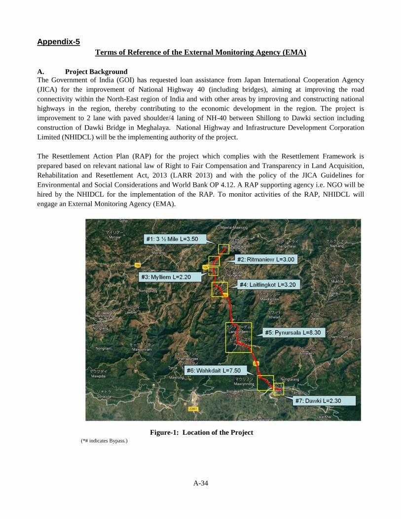
A-34
Appendix-5
Terms of Reference of the External Monitoring Agency (EMA)
A. Project Background
The Government of India (GOI) has requested loan assistance from Japan International Cooperation Agency
(JICA) for the improvement of National Highway 40 (including bridges), aiming at improving the road
connectivity within the North-East region of India and with other areas by improving and constructing national
highways in the region, thereby contributing to the economic development in the region. The project is
improvement to 2 lane with paved shoulder/4 laning of NH-40 between Shillong to Dawki section including
construction of Dawki Bridge in Meghalaya. National Highway and Infrastructure Development Corporation
Limited (NHIDCL) will be the implementing authority of the project.
The Resettlement Action Plan (RAP) for the project which complies with the Resettlement Framework is
prepared based on relevant national law of Right to Fair Compensation and Transparency in Land Acquisition,
Rehabilitation and Resettlement Act, 2013 (LARR 2013) and with the policy of the JICA Guidelines for
Environmental and Social Considerations and World Bank OP 4.12. A RAP supporting agency i.e. NGO will be
hired by the NHIDCL for the implementation of the RAP. To monitor activities of the RAP, NHIDCL will
engage an External Monitoring Agency (EMA).
Figure-1: Location of the Project
(*# indicates Bypass.)
A-35
B. Key Objective of External Monitoring
Monitoring involves the collection and analysis of data on resettlement activities with the applying accruing
information. Monitoring allows project participants to keep track of resettlement activities, to determine whether
resettlement objectives are being achieved, and to make whatever changes are necessary to improve resettlement
performance.
Evaluation is an assessment of resettlement performance and results in light of stated the objectives. Evaluation
for purposes of the RAP is proposed to include a participatory component allowing the project participants to
comment on their experience of the project. To be successful, monitoring and evaluation begins with clear
resettlement design followed by identification and elaboration of appropriate criteria and indicators.
Indicators and Means for Verification
Indicators form the key elements of any monitoring and evaluation system. Indicators also make possible the
comparison of inputs with the completion of outputs and achievement of objectives and goals, thus providing the
basis for performance evaluation. Four categories of indicators have been formulated to facilitate monitoring of
Progress, Outputs, Effects, Impacts and Compliance in implementing the resettlement.
Effect Monitoring
This will be used to measure the extent to which the immediate objectives have been achieved and give an idea
of the results emanating from implementing the RAP e.g., percentage of APs now accessing better housing or
improved livelihoods on account of being successfully resettled.
Impact Monitoring
This is the process through which, assessment of the overall achievement of the resettlement goal will be made.
Specifically, this is the system that will generate data to gauge success towards implementation of this RAP in
terms of impact of the resettlement on the APs. The basis for impact monitoring is the baseline social-economic
survey data against which the wellbeing of APs will be compared.
The Independent External Monitoring Agency (EMA) will review implementation process as per set policies in
the RAP and assess the achievement of resettlement objectives, the changes in living standards and livelihoods,
restoration of the economic and social base of the affected people, the effectiveness, impact and sustainability of
entitlements, the need for further mitigation measures if any, and to learn strategic lessons for future policy
formulation and planning.
Scope of Work
The scope of work of the Independent EMA will include the following tasks:
(1) To review and verify the progress in land acquisition/resettlement implementation of the Project and
whether they have been followed as provided in the RAP.
(2) Provide a summary of whether involuntary resettlement was implemented (a) in accordance with the RAP,
and (b) in accordance with the stated policy.
(3) Verify expenditure & adequacy of budget for resettlement activities.
(4) Describe any outstanding actions that are required to bring the resettlement activities in line with RAP.
Describe further mitigation measures needed to meet the needs of any affected person or families judged
and/or perceiving themselves to be worse off as a result of the Project. Provide a timetable and define
budget requirements for these supplementary mitigation measures.
(5) Describe any lessons learned that might be useful in developing the new national resettlement policy and
legal/institutional framework for involuntary resettlement.
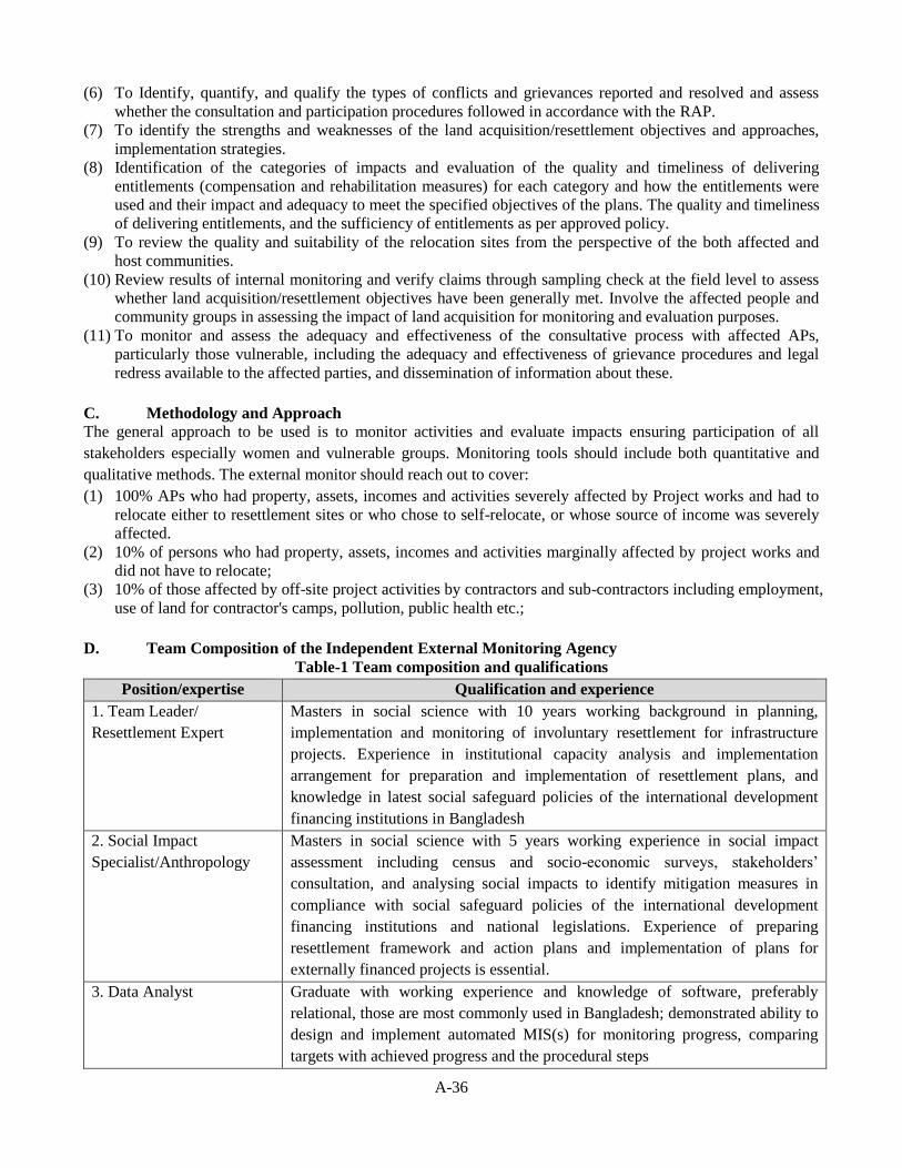
A-36
(6) To Identify, quantify, and qualify the types of conflicts and grievances reported and resolved and assess
whether the consultation and participation procedures followed in accordance with the RAP.
(7) To identify the strengths and weaknesses of the land acquisition/resettlement objectives and approaches,
implementation strategies.
(8) Identification of the categories of impacts and evaluation of the quality and timeliness of delivering
entitlements (compensation and rehabilitation measures) for each category and how the entitlements were
used and their impact and adequacy to meet the specified objectives of the plans. The quality and timeliness
of delivering entitlements, and the sufficiency of entitlements as per approved policy.
(9) To review the quality and suitability of the relocation sites from the perspective of the both affected and
host communities.
(10) Review results of internal monitoring and verify claims through sampling check at the field level to assess
whether land acquisition/resettlement objectives have been generally met. Involve the affected people and
community groups in assessing the impact of land acquisition for monitoring and evaluation purposes.
(11) To monitor and assess the adequacy and effectiveness of the consultative process with affected APs,
particularly those vulnerable, including the adequacy and effectiveness of grievance procedures and legal
redress available to the affected parties, and dissemination of information about these.
C. Methodology and Approach
The general approach to be used is to monitor activities and evaluate impacts ensuring participation of all
stakeholders especially women and vulnerable groups. Monitoring tools should include both quantitative and
qualitative methods. The external monitor should reach out to cover:
(1) 100% APs who had property, assets, incomes and activities severely affected by Project works and had to
relocate either to resettlement sites or who chose to self-relocate, or whose source of income was severely
affected.
(2) 10% of persons who had property, assets, incomes and activities marginally affected by project works and
did not have to relocate;
(3) 10% of those affected by off-site project activities by contractors and sub-contractors including employment,
use of land for contractor's camps, pollution, public health etc.;
D. Team Composition of the Independent External Monitoring Agency
Table-1 Team composition and qualifications
Position/expertise Qualification and experience
1. Team Leader/
Resettlement Expert
Masters in social science with 10 years working background in planning,
implementation and monitoring of involuntary resettlement for infrastructure
projects. Experience in institutional capacity analysis and implementation
arrangement for preparation and implementation of resettlement plans, and
knowledge in latest social safeguard policies of the international development
financing institutions in Bangladesh
2. Social Impact
Specialist/Anthropology
Masters in social science with 5 years working experience in social impact
assessment including census and socio-economic surveys, stakeholders’
consultation, and analysing social impacts to identify mitigation measures in
compliance with social safeguard policies of the international development
financing institutions and national legislations. Experience of preparing
resettlement framework and action plans and implementation of plans for
externally financed projects is essential.
3. Data Analyst Graduate with working experience and knowledge of software, preferably
relational, those are most commonly used in Bangladesh; demonstrated ability to
design and implement automated MIS(s) for monitoring progress, comparing
targets with achieved progress and the procedural steps
A-37
E. Time Frame and Reporting
External monitoring of the RAP will be undertaken alongside that of other project components. EMA will take
place as follows:
Post Project Monitoring:
In order to determine final impacts of the resettlement activity, a final evaluation cum an impact assessment will
be undertaken 6 months after conclusion of resettlement to evaluate whether the intended objectives were
realised. For this, suitable baseline indicators related to income, assets, land ownership, expenditure pattern of
key activities, housing conditions, access to basic amenities, demographic characteristics, indebtedness, etc. will
be applied.
The monitoring reports should be submitted to NHIDCL. An evaluation report at the end of the project should be
submitted to the NHIDCL and concerned parties with critical analysis of the achievement of the program and
performance of NHIDCL and Rehabilitation & Resettlement Committee.
The external monitors will provide monitoring and evaluation report covering the following aspects:
Whether the resettlement activities have been completed as planned and budgeted;
The extent to which the specific objectives and the expected outcomes/results have been achieved and the
factors affecting their achievement or non-achievement;
The extent to which the overall objective of the Resettlement Plan, pre project or improved social and
economic status, livelihood status, have been achieved and the reasons for achievement / non achievement;
Major areas of improvement and key risk factors;
Major lessons learnt; and
Recommendations.
Formats for collection and presentation of monitoring data will be designed in consultation with NHIDCL,
consultant’s resettlement specialist.
F. Qualification of the Independent External Monitoring Agency
The I-EMA will have at least 5 years of experience in resettlement policy analysis and implementation of
resettlement plans. Further, work experience and familiarity with all aspects of resettlement operations would be
desirable. NGOs, Consulting Firms having requisite capacity and experience as follows can qualify for services
of and external monitor for the project.
(1) NGOs, Consulting firms duly registered with GOI agencies or a department of any recognized university is eligible.
(2) The applicant should have prior experience in social surveys in land based infrastructure projects and
preparation of Resettlement Action Plan (RAP) as per guidelines on involuntary resettlement of any of the
JICA, ADB and World Bank.
(3) The applicant should have extensive experience in implementation and monitoring of resettlement plans, including the preparation of implementation tools.
(4) The applicant should be able to produce evidences of monitoring using tools such as computerized Management Information System with set criteria for measuring achievement.
(5) The applicant should have adequate manpower with capacity and expertise in the field of planning,
implementation and monitoring of involuntary resettlement projects as per donor's guidelines.
End