preparing for the storm: preserving water resources with ... · stressed aquatic ecosystems lose...
TRANSCRIPT

P o l i c y S t u d y N o . 2 7 5
Preparing for the Storm: Preserving Water Resources with Stormwater Utilities
BY BARRETT P. WALKER
Executive Summary
ommon practices for protecting water resources often fail to maintain either good water quality or healthy ecosystems. This failure is not due to a failure to control pollutant releases of sewage and industrial effluent so much as it is due to altered hydrology caused by the handling of stormwater runoff. Numerous studies link uncontrolled stormwater runoff from areas with impervious surface
exceeding 10 percent to a rapid decline in water quality and stream health. Streams draining residential suburbs with typically high levels of impermeable surface experience two to five times the stream-channel enlargement of areas with less impermeable surface, endure increased flooding, are prone to low flow during droughts, and are biologically nonsupporting. Traditionally, public entities have managed urban water resources using what might be characterized as a civil engineering, or technocratic approach that treats stormwater as a waste product of development. But the hydrologic cycle is too complex to respond predictably to such a rigid, narrow approach. Moreover, this approach reinforces, or even encourages, land-use practices that can substantially disrupt the hydrological cycle. Responsibility for stormwater management is generally dispersed between various government agencies and departments. Stormwater systems are rarely built to handle runoff from anticipated future development. Inadequate design coupled with a lack of funds for maintenance often force managers to react to problems such as poor water quality and flooding with short-term, piecemeal solutions. A number of political jurisdictions scattered across America are implementing innovative approaches to stormwater management. One such approach is the creation of user-fee based stormwater utilities to improve urban watershed and stormwater management. Case studies show that communities adopting this form of
C

management can produce better water quality, healthier urban ecosystems, and improved quality of life. Such systems link the decisions of people who impact stormwater flows to the stormwater management system directly through a fee system linked to usage and impacts. The cost-based, user-fee-funded stormwater utility encourages the recognition of stormwater as a resource, not simply as an event to be managed. The utility concept focuses management in a single organization, which can be public, private, or some combination thereof. Creation of a utility allows for dedicated infrastructure and management funding, with fees tied to impacts. The approach enables development of comprehensive preventative and enhancement programs. New federal requirements for stormwater permits affecting smaller cities and court-mandated enforcement of the Clean Water Act on a watershed basis are spurring many municipalities to consider the user-fee concept for dedicated funding of improved stormwater management. Over 350 stormwater utilities have been formed nationwide, most in the last decade. Stormwater utilities can provide an equitable means for many communities to fund improvements in water quality and reduce flood damage. However, achieving the goal of swimmable and fishable waters stated in the Federal Clean Water Act may eventually require additional steps such as comprehensive water resource management that combines water supply, sanitary sewage, stormwater drainage, and wildlife protection under a watershed-scale integrated water utility. Three case studies illustrate the experiences of cities that have established stormwater utilities. Stormwater utilities can encourage development that uses natural hydrological cycles to maintain water quality and flourishing ecosystems. Bellevue, Washington, which established one of the first stormwater utilities in the nation, demonstrates that designing “with nature” can reduce the negative impact of impervious surfaces on aquatic systems, while creating highly desirable neighborhoods. Charlotte, North Carolina shows that stormwater controls can be retrofitted to already-developed neighborhoods through bioengineering of retention ponds and other steps such as stream-habitat improvements. Atlanta’s experience is more mixed, showing how the technocratic approach to water management is unsustainable, and a case history of mistakes to avoid in establishing a stormwater utility. Rather than adopting growth boundaries or other regulatory approaches that put broad areas of private land off-limits to development, this study recommends that a market-based approach integrating economic and ecosystem needs could be implemented based on the following principles: 1. Implement cost-based user fees that equitably assign the cost of services, with customers creating the
greatest impact paying the highest fee. A user-fee-based stormwater utility could set charges based on the amount of impervious surface area. Stormwater utilities could also reduce fees for on-site stormwater control, superior pollutant control, and protection of sensitive areas such as wetlands. User fees give land developers, builders, and property owners an incentive to minimize environmental impacts. User fees can also pay for mitigation of the negative impacts of development. In addition, user fees can lessen dependence on property taxes, which weaken the linkage between costs and benefits.
2. Operate the stormwater utility using adaptive management. Adaptive management is defined as a process for improving resource management incrementally as managers and scientists learn from new experience and scientific findings. This process is in contrast to the more rigid civil engineering or technocratic approach traditionally used by public entities for managing water resources. Like other

systems in nature, the hydrologic cycle, which recycles earth’s water, is dynamic, adapting to change through feedback loops that work to restore equilibrium. The cost-based, user-fee rate structure establishes a feedback loop between impacts on the natural system, and the fees charged to maintain nature’s services for recycling clean water. Performance is measured by evaluating stormwater damage to property and the health of the aquatic system.
3. Reduce wasteful administrative conflicts through comprehensive water resource management at the local level by combining water supply, sanitary sewage, stormwater drainage, and wildlife protection under an integrated water utility that could be privately managed (or even privately owned).
4. Purchase and preserve land with a high ecosystem value. Watersheds threatened with new development should be surveyed to classify the land according to its ecosystem value. Land with a high ecosystem value could be purchased and preserved by a regional stormwater or water resource utility, following a strategy of pollution prevention that could ultimately be less expensive and result in a more livable community.
This study recommends that a market-based approach integrating economic and ecosystem needs could be implemented
5. Reward owners of environmentally sensitive property, such as wetlands and vegetated stream buffers, who minimize disturbance. This can be approached in three ways: reduced fees, reduced property taxes, and the purchase of conservation easements that confer tax benefits. Where the ecosystem value of the land does not merit purchase but there is still a need to reduce disturbance, facilitating private stewardship in this manner provides a flexible alternative.
6. Phase out or sharply restrict repeated claims on federal flood insurance. By paying property owners who repeatedly sustain flood damage, federal flood insurance has encouraged development on flood-prone, ecologically valuable land. During phase-out, payouts could be used to relocate people who are flooded to less flood-prone areas, rather than to fund rebuilding.
7. Where practicable, replace federally managed efforts to control nature through public works projects such as construction of dams, levees, and dredging, with prevention-oriented watershed management.
8. Make zoning and stormwater codes more flexible and effective by implementing performance-based measures tied to improvements in ecosystem health and reductions in flood damage.
9. Address the issue of landscape fragmentation—the need for a connected network of riparian corridors—by fostering public-private partnerships that combine private funding with federal funds redirected away from federal public works projects and toward support of regional river-basin initiatives.
10. Improve service and control costs by contracting with private companies for services where feasible.

Pol icy Study No. 275
Table of Contents INTRODUCTION............................................................................................................... 1 A. The Technocratic Approach is Limited...................................................................................................... 2 B. The Problem Is Widespread...................................................................................................................... 7 C. Urbanization Causes Increasing Impacts............................................................................................... 12 D. The Economic Importance of the Hydrologic Cycle Is Ignored............................................................. 21
PROTECTING WATERSHEDS .......................................................................................... 24 A. Market-based Ecosystem Management................................................................................................... 26 B. The Stormwater Utility ........................................................................................................................... 27
KEY POLICY CHALLENGES .............................................................................................. 33 A. Taking a Watershed View........................................................................................................................ 33 B. Disentangling Stormwater Management from Sewage Treatment......................................................... 35 C. Obtaining Interstate Cooperation.......................................................................................................... 35 D. Fostering Community-based Watershed Protection............................................................................... 37
NEW MARKET APPROACHES IN ACTION....................................................................... 38 A. Bellevue, Washington: User Fees Tied to Impervious Surface................................................................ 38 B. Charlotte: User Fees, Rewards, and Private Contracting ........................................................................ 41 C. Atlanta: When Is a Fee a Tax? ................................................................................................................. 42 D. Druid Hills, Atlanta: A Market-inspired Alternative ............................................................................... 44
IMPLICATIONS FOR THE FUTURE.................................................................................. 48 A. Watershed-management Organizations, User Fees, and Privatization ......................................................... 48 B. Effluent Trading and Stormwater Utilities.............................................................................................. 51
ABOUT THE AUTHOR..................................................................................................... 53
OTHER RELEVANT RPPI POLICY STUDIES...................................................................... 53

PREPARING FOR THE STORM 1
P a r t 1
Introduction
ities rely upon a clean supply of fresh water for their economic health, yet the expansion of urbanized areas can threaten this vital resource. Until recently, urban growth was seldom constrained by a shortage of clean water because high-quality supplies were relatively abundant in most areas of the United States. But “water wars,” originally limited to the arid West, now erupt even in the humid
Southeast, as municipalities and states wage legal battles over access to the remaining unspoiled water sources. Traditionally, public entities have managed urban water resources, using what might be characterized as a civil engineering or technocratic approach. But the hydrologic cycle is too complex to respond predictably to such a rigid, narrow approach. Moreover, this approach reinforces, or even encourages, land-use development practices that can substantially disrupt the hydrological cycle. Under the traditional approach:
Land slated for development (either infill or new development) is bulldozed to remove vegetation and the site is leveled, destroying the site’s ability to intercept rainfall and detain it while it soaks into the ground and recharges groundwater. After development, impervious rooftops and pavement often block groundwater recharge and result in rapid surface runoff.
Underground storm drains are installed that dump runoff into nearby streams in an effort to drain road runoff and reduce development-induced local flooding, But this water, sped through pipes, enters stream channels at unnaturally high flow rates, eroding stream channels and degrading aquatic ecosystems.
Dams are often constructed to form storage reservoirs to compensate for the resulting loss in natural storage capacity from depleted groundwater and filled wetlands and to offset increased downstream flooding.
A number of adverse impacts occur as the result of these traditional development practices:
Erosion from new development sites, followed by erosion from urban-induced stream-channel enlargement, damages urban infrastructure and fills reservoirs with sediment, shortening their life and further degrading water quality.
Impervious surfaces act as collecting surfaces for pollutants between rainfalls. When rain does fall, the accumulated fallout from air pollution, leaked motor oil, heavy-metal particles, pesticides, fertilizers, pet wastes, road salt, and other substances are concentrated in a first flush of contamination that washes into streams and lakes, causing significant harm to the stream’s ecosystem.
Urban development practices that clear-cut land raise summer temperatures and lower dissolved oxygen in streams, stressing aquatic ecosystems. Removal of the tree canopy also increases runoff of stormwater and sediment, and the higher temperatures of urban heat islands can increase smog formation, stressing humans and natural systems.
C

2 RPPI
Stressed aquatic ecosystems lose the ability to maintain flow equilibrium and assimilate wastes, often leading to political demands for disaster relief, construction of ever-more expensive flood-control structures, drinking water reservoirs, and pollution-treatment plants.
The combination of these impacts undermines the hydrologic cycle required for ecosystem health and human well-being. Although specific conditions vary based on local development patterns and hydrology, most of the East and an increasing area of the West are affected. Dealing with these negative impacts creates huge costs as communities age.
A. The Technocratic Approach is Limited Atlanta provides an example of how the current technocratic approach to water management is unsustainable. The Chattahoochee River, by far the largest source of water to Metro Atlanta, was dammed north of the city during the 1950s, forming Lake Sidney Lanier. Water released by the dam supplies drinking water to more than three million Atlantans. In response to widespread concerns that development in the watershed surrounding the lake was leading to siltation and water quality problems, a $2-million study was commissioned. Released in 1997, the study estimated it would be only 15 years before silt and other pollution from unchecked growth would kill the fish in the lake.1 A second reservoir northwest of the city is Lake Allatoona on the Etowah River. A pipeline was proposed to transfer water from Lake Allatoona to Lake Lanier in order to meet Atlanta’s growing needs.2 But due to rapid development and its smaller size, Lake Allatoona is filling with silt even faster than Lake Lanier. A study on Allatoona concluded the lake might be unable to support fish within 10 years.3 Although strong opposition makes it almost certain the project will never be built, it illustrates the type of planning characteristic of the technocratic approach that emphasizes large public works projects to store, transport, and treat water, rather than protection of water at its source. Such failures cause significant environmental damage and can impose significant costs on municipalities. An example of these costs is provided by one of the 10 counties in the Metro Atlanta area. Cobb County, which draws water from Lake Allatoona, reported a $300,000 increase in the cost of treatment chemicals in 1999 out of a $4-million budget.4 Although increasing treatment costs for drinking water are only a tiny fraction of the full cost of damages that accrue from such failed management practices, the Allatoona example is a useful reference point. Although poorly treated sewage and other types of pollution are major causes of urban water-quality impairment, the key condition limiting the recovery of urban streams in most locations is altered hydrology, including stormwater runoff. A number of studies link uncontrolled stormwater runoff from areas with impervious surface exceeding 10 percent to a rapid decline in water quality and stream health. Streams draining areas with 25 to 30 percent
1 Stacy Shelton, “Lake Lanier: Pollution, Growth Still a Threat,” The Atlanta Journal-Constitution, February 5, 2000, p. C1-C2. 2 Chris Reinolds, “Barr: No Allatoona Pipeline to Atlanta,” The Atlanta Journal-Constitution, December 14, 1999, p. D10. 3 Stacy Shelton, “Lake Lanier: Pollution, Growth Still a Threat,” The Atlanta Journal-Constitution, February 5, 2000, p. C1-C2. 4 Chris Reinolds, “High Pollution Levels Threaten Lake Allatoona,” The Atlanta Journal-Constitution, February 5, 2000, p. F1.

PREPARING FOR THE STORM 3
impervious cover, typical of residential suburbs, experience stream channel enlargement from two to five times, increased flooding, and reduced biological-support functions.5 For example, historic Druid Hills in metropolitan Atlanta serves as the site for a paired watershed study in which two nearby catchments, nearly identical except for different levels of impervious cover, were intensively studied over time to assess comparative conditions and impacts.6 Figure 1 shows a bird’s-eye view of the two catchments. The catchment in Fernbank Forest, an urban forest preserve, serves as the reference watershed. Impervious surface area in the Fernbank Forest watershed was measured at only five percent. The other watershed in the comparison, with 19 percent impervious cover, is a residential neighborhood surrounding Olmsted-designed Deepdene Park.
Figure 1: Aerial View of Paired Watershed Study Sites in Atlanta
Source: Illustration and data by Author, aerial photos DeKalb County, GA.
The two watersheds shown in Figure 1 are nearly identical except for the amount of impervious surface area associated with residential development. Fernbank, with 5 percent impervious area, was drained by a healthy stream that exhibited few signs of erosion. Deepdene, at 19 percent impervious area, had an unhealthy stream scoured by surges of stormwater from surrounding roads. During dry weather, the stream draining Deepdene had less base flow than the stream draining Fernbank.
5 Deb Caraco, Rich Claytor, et al., Rapid Watershed Planning Handbook: A Comprehensive Guide for Managing Urbanizing
Watersheds (Ellicott City Maryland: Center for Watershed Protection, October 1998). 6 A catchment, or watershed, is an area which traps rainfall, and guides it to a particular body of water, such as a lake, river, or reservoir.
4 RPPI
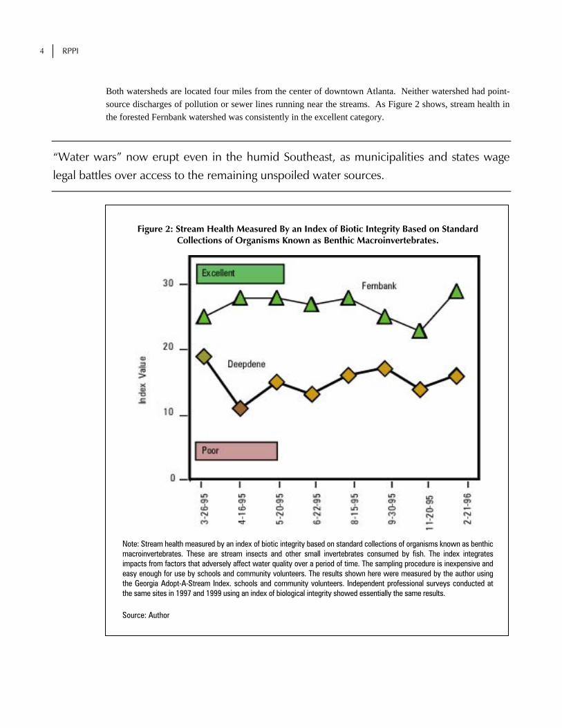
Both watersheds are located four miles from the center of downtown Atlanta. Neither watershed had point-source discharges of pollution or sewer lines running near the streams. As Figure 2 shows, stream health in the forested Fernbank watershed was consistently in the excellent category.
“Water wars” now erupt even in the humid Southeast, as municipalities and states wage legal battles over access to the remaining unspoiled water sources.
Figure 2: Stream Health Measured By an Index of Biotic Integrity Based on Standard Collections of Organisms Known as Benthic Macroinvertebrates.
Note: Stream health measured by an index of biotic integrity based on standard collections of organisms known as benthic macroinvertebrates. These are stream insects and other small invertebrates consumed by fish. The index integrates impacts from factors that adversely affect water quality over a period of time. The sampling procedure is inexpensive and easy enough for use by schools and community volunteers. The results shown here were measured by the author using the Georgia Adopt-A-Stream Index. schools and community volunteers. Independent professional surveys conducted at the same sites in 1997 and 1999 using an index of biological integrity showed essentially the same results.
Source: Author

PREPARING FOR THE STORM 5
Even though the headwaters showed some early signs of erosion from surface flow of stormwater off paved areas bordering the watershed, most of the stream looked healthy, with vegetated banks as shown in Figure 3. Note that in Fernbank, none of the paved areas drained directly into the stream.
A number of studies link uncontrolled stormwater runoff from areas with impervious surface exceeding 10 percent to a rapid decline in water quality and stream health.
Figure 3: Stream Draining the Fernbank Watershed
Source: Photo by Author
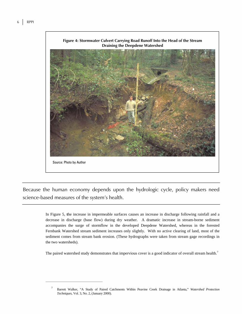
By comparison, as Figure 4 shows, the stream draining the lightly developed residential neighborhood surrounding Deepdene Park was badly eroded by stormwater discharged from road-drainage culverts. Its biotic health was fair on average, varying from poor following a storm event to good after a long period of favorable weather. The impaired condition of the Deepdene stream was best explained by changes in stream flow and sediment loading, as shown in Figure 5, caused by stormwater runoff from impervious surfaces.
6 RPPI
Figure 4: Stormwater Culvert Carrying Road Runoff Into the Head of the Stream Draining the Deepdene Watershed
Source: Photo by Author
Because the human economy depends upon the hydrologic cycle, policy makers need science-based measures of the system’s health.
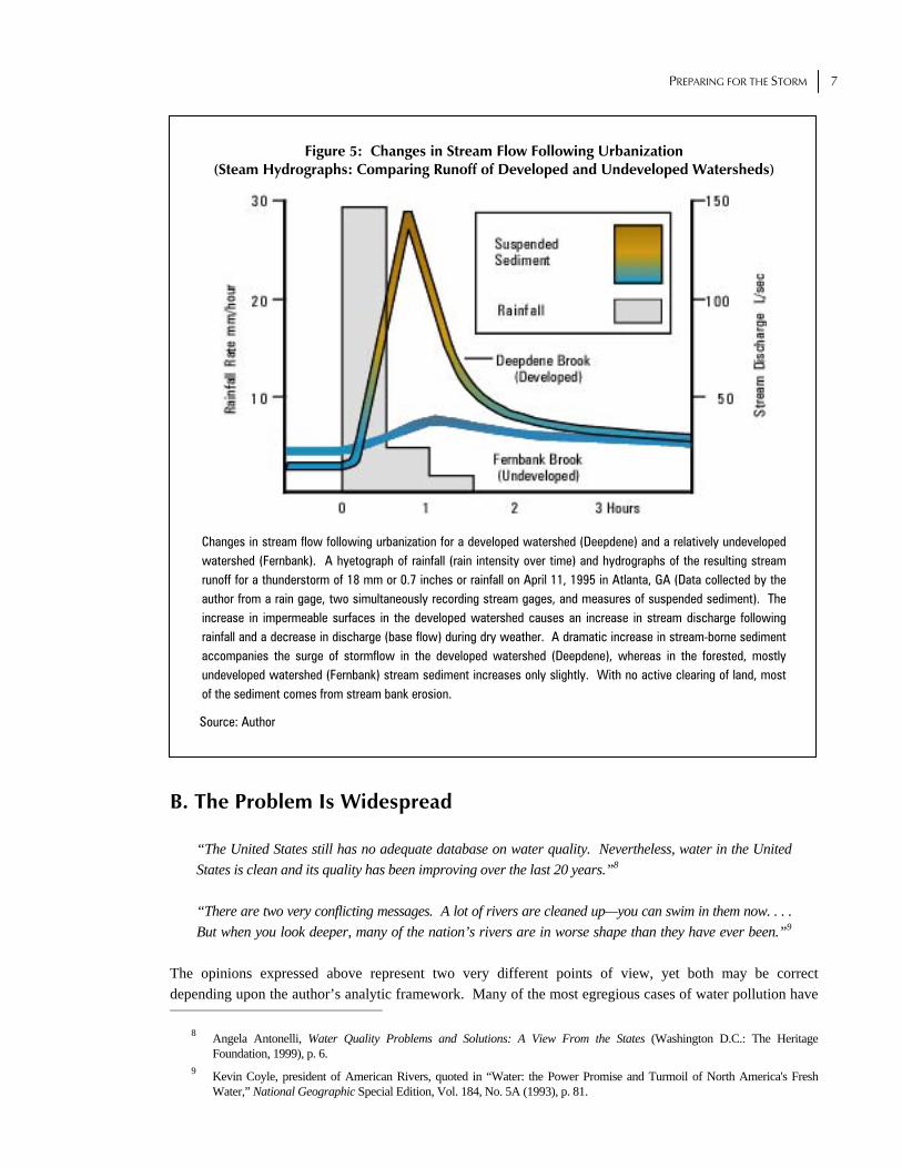
In Figure 5, the increase in impermeable surfaces causes an increase in discharge following rainfall and a decrease in discharge (base flow) during dry weather. A dramatic increase in stream-borne sediment accompanies the surge of stormflow in the developed Deepdene Watershed, whereas in the forested Fernbank Watershed stream sediment increases only slightly. With no active clearing of land, most of the sediment comes from stream bank erosion. (These hydrographs were taken from stream gage recordings in the two watersheds). The paired watershed study demonstrates that impervious cover is a good indicator of overall stream health.7
7 Barrett Walker, “A Study of Paired Catchments Within Peavine Creek Drainage in Atlanta,” Watershed Protection Techniques, Vol. 3, No. 2, (January 2000).
PREPARING FOR THE STORM 7
Figure 5: Changes in Stream Flow Following Urbanization (Steam Hydrographs: Comparing Runoff of Developed and Undeveloped Watersheds)
Changes in stream flow following urbanization for a developed watershed (Deepdene) and a relatively undeveloped watershed (Fernbank). A hyetograph of rainfall (rain intensity over time) and hydrographs of the resulting stream runoff for a thunderstorm of 18 mm or 0.7 inches or rainfall on April 11, 1995 in Atlanta, GA (Data collected by the author from a rain gage, two simultaneously recording stream gages, and measures of suspended sediment). The increase in impermeable surfaces in the developed watershed causes an increase in stream discharge following rainfall and a decrease in discharge (base flow) during dry weather. A dramatic increase in stream-borne sediment accompanies the surge of stormflow in the developed watershed (Deepdene), whereas in the forested, mostly undeveloped watershed (Fernbank) stream sediment increases only slightly. With no active clearing of land, most of the sediment comes from stream bank erosion.
Source: Author
B. The Problem Is Widespread
“The United States still has no adequate database on water quality. Nevertheless, water in the United States is clean and its quality has been improving over the last 20 years.”8 “There are two very conflicting messages. A lot of rivers are cleaned up—you can swim in them now. . . . But when you look deeper, many of the nation’s rivers are in worse shape than they have ever been.”9
The opinions expressed above represent two very different points of view, yet both may be correct depending upon the author’s analytic framework. Many of the most egregious cases of water pollution have
8 Angela Antonelli, Water Quality Problems and Solutions: A View From the States (Washington D.C.: The Heritage Foundation, 1999), p. 6.
9 Kevin Coyle, president of American Rivers, quoted in “Water: the Power Promise and Turmoil of North America's Fresh Water,” National Geographic Special Edition, Vol. 184, No. 5A (1993), p. 81.

8 RPPI
been cleaned up—the Cuyahoga River in Cleveland that caught fire in 1969 will almost certainly never catch fire again. Yet scientific evidence supports the view that many of the nation’s surface waters are losing their ability to support life.10 As described later in this report, stream health is particularly poor within and downstream from urban areas. Currently available data help illuminate the nature of this water-quality problem. Table 1 shows National water quality data compiled by the U.S. Environmental Protection Agency (EPA) from reports submitted by the states based on meeting so-called designated uses, as required by the 1972 federal Clean Water Act. Designated uses include fishing, swimming, and drinking.
Table 1: Status of the Nation’s Surface-water Quality, 1988-1994 Item Rivers Lakes1 Estuaries
'88 '90 '92 '94 '88 '90' '92 '94 '88 '90 '92 '94
Percent of total water
Water systems assessed 29 36 18 17 41 47 46 42 72 75 74 78
Percent of assessed water
Meeting designated uses Supporting 70 69 62 64 74 60 56 63 89 67 68 63 Partially supporting 20 21 25 22 17 19 35 28 8 25 23 27 Not supporting 10 10 13 14 10 21 9 9 3 8 9 9
Clean Water Act goal of fishable Meeting 86 80 66 69 95 70 69 69 97 77 78 70 Not meeting 11 19 34 31 5 30 31 31 3 23 22 30 Not attainable 3 1 - - - 0 - - 0 - 0 0
Clean Water Act goal of swimmable Meeting 85 75 71 77 96 82 77 81 92 88 83 85 Not meeting 11 15 20 23 4 18 22 19 1 12 17 15 Not attainable 4 10 9 - - - - - 7 - 0 -
Notes: - = Less than one percent of assessed waters 1 Excluding Great Lakes Sources include USDA, ERS, based on Environmental Protection Agency National Water Quality Inventories, 1988, 1990, 1992, 1994.
Source: United States Department of Agriculture, USDA Handbook, No. 712 (Washington, D.C., July 1997). A major problem with state data is that methods for collection and analysis are not subject to uniform quality-control procedures. This does not mean that quality control is completely lacking, but the procedures vary. The sites selected for testing may also bias the results since there is no nationwide randomized sampling procedure. Nonetheless, very different impressions of water quality can be conveyed using the same source.11 Someone promoting the view that water quality is not a problem could accurately state that only 14 percent of America’s rivers surveyed in 1994 did not meet their designated uses. Although accurate, the statement is misleading. It does not mention that only a small portion (17 percent) of river miles were surveyed or that many of the river miles were only partially supporting (22 percent), which means that the waters met their designated use only part of the time and were therefore impaired. On the other hand, someone promoting the view that water quality is a problem could accurately state: “All that can be said with certainty is that 11
10 U.S. Environmental Protection Agency, Office of Policy, Planning and Evaluation, Summary of State Biological Assessment Programs for Streams and Rivers (Washington, D.C., February 1996).
11 U.S. Department of Agriculture, ERS Agricultural Handbook, No. 712 (Washington, D.C., July 1997), Table 2.2.1.

PREPARING FOR THE STORM 9
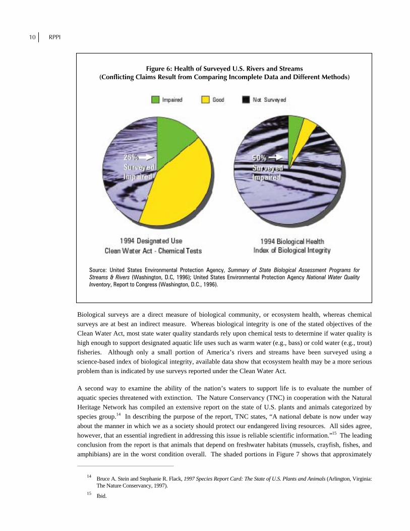
percent of our river miles were not impaired in 1994.” This statement is accurate but misleading because it implies that 89 percent of rivers are unhealthy. Because the human economy depends upon the hydrologic cycle, policy makers need science-based measures of the system’s health. The cycle consists of a combination of physical and biological processes. Due to the complexities of atmospheric circulation, measuring the physical component is fraught with as many difficulties as those facing climate-change researchers addressing the question of global warming. A more feasible and less controversial approach is to measure the biological component of the system as reflected by the health of aquatic organisms. This increasingly applied approach uses science-based indices of biotic integrity. During the last decade, 30 states plus the District of Columbia began surveying waters using measures of ecosystem health. Although completed surveys cover only a tenth of all surface waters, half the waters surveyed are biologically impaired.12 More extensive surveys are available for water meeting designated-use categories (fishing, swimming, and drinking) and for aquatic species threatened with extinction. Designated-use surveys have been reported by states for half of all United States surface waters. According to the U.S. Environmental Protection Agency (EPA), the surveys show that 40 percent of surveyed waters are impaired and that 50 percent of impaired rivers are affected by urban and construction sources of stormwater runoff.13 Although aquatic-use surveys are the most complete surveys available, they are incomplete indicators of aquatic health. The surveys are based primarily on a series of physical, chemical, and bacterial tests. Because the tests are generally spot checks, not continuous measurements, they frequently miss events (such as post-storm pollutant spikes, or sewage spills) that can kill entire communities of higher aquatic organisms (and sicken humans). Chemical surveys that are complete enough to screen for the thousands of possible contaminants are prohibitively expensive. Hence, more affordable, less complete surveys are the norm. By comparison, sensitive biological surveys are relatively inexpensive and are considered by many experts to better reflect the cumulative impacts of altered hydrology, habitat loss, and chemical toxins. Figure 6 shows rivers and streams surveyed for meeting both designated use categories and biological health. Thirty states plus the District of Columbia and the Ohio River Valley Sanitation Commission have numeric data of sufficient quantity to be confident in the determination of biological integrity. The designated use category refers to water quality objectives, or uses, established by states under the Clean Water Act for the protection of fisheries (aquatic life designated uses). Since most states rely on chemical standards to represent conditions that protect aquatic life, the results can be quite different from those obtained by direct biological sampling. These data are for perennial rivers and streams flowing throughout the year and exclude nonperennial stream miles. Figure 6 compares two surveys on the health of U.S. rivers and perennial streams. (Lakes, reservoirs, and estuaries are not included in this comparison.) The same group of 32 states and territories reported both surveys in the same year. The left chart displays the percentage of rivers and streams that supported, or failed to support their designated use category. The right chart displays the percentage of rivers and streams considered impaired or good based on an index of biological integrity.
12 U.S. Environmental Protection Agency, Summary of State Biological Assessment Programs for Streams and Rivers. 13 U.S. Environmental Protection Agency, Office of Water, Storm Water Phase II Proposed Rule: An Overview, Fact Sheet 833-
F-99-001 (Washington D.C., April 1999), p. 1.
10 RPPI
Figure 6: Health of Surveyed U.S. Rivers and Streams (Conflicting Claims Result from Comparing Incomplete Data and Different Methods)
Source: United States Environmental Protection Agency, Summary of State Biological Assessment Programs for Streams & Rivers (Washington, D.C, 1996); United States Environmental Protection Agency National Water Quality Inventory, Report to Congress (Washington, D.C., 1996).
Biological surveys are a direct measure of biological community, or ecosystem health, whereas chemical surveys are at best an indirect measure. Whereas biological integrity is one of the stated objectives of the Clean Water Act, most state water quality standards rely upon chemical tests to determine if water quality is high enough to support designated aquatic life uses such as warm water (e.g., bass) or cold water (e.g., trout) fisheries. Although only a small portion of America’s rivers and streams have been surveyed using a science-based index of biological integrity, available data show that ecosystem health may be a more serious problem than is indicated by use surveys reported under the Clean Water Act. A second way to examine the ability of the nation’s waters to support life is to evaluate the number of aquatic species threatened with extinction. The Nature Conservancy (TNC) in cooperation with the Natural Heritage Network has compiled an extensive report on the state of U.S. plants and animals categorized by species group.14 In describing the purpose of the report, TNC states, “A national debate is now under way about the manner in which we as a society should protect our endangered living resources. All sides agree, however, that an essential ingredient in addressing this issue is reliable scientific information.”15 The leading conclusion from the report is that animals that depend on freshwater habitats (mussels, crayfish, fishes, and amphibians) are in the worst condition overall. The shaded portions in Figure 7 shows that approximately
14 Bruce A. Stein and Stephanie R. Flack, 1997 Species Report Card: The State of U.S. Plants and Animals (Arlington, Virginia: The Nature Conservancy, 1997).
15 Ibid.

PREPARING FOR THE STORM 11
half of freshwater aquatic species groups are extinct, imperiled, or vulnerable to extinction. (Though the reasons are unclear, amphibians, a group that inhabits both freshwater and terrestrial habitats, have 40 percent of species threatened with extinction.) Why should we care about the possible loss of freshwater species when so many of them are seldom seen? In addition to their value as a genetic resource, their role in the food chain, and their aesthetic value, many of the aquatic organisms play an important role in keeping waterways healthy for human use. Freshwater mussels, one of the least noticed and most threatened species groups, are mollusks that live on the bottom and feed by filtering minute organisms from the surrounding water. Mussels remove suspended particles that bacteria attach to and keep the water clear. Mussels are vulnerable to extinction because they are long lived (some species up to 50 years or more), and susceptible to suffocation by sediment and poisoning by chemicals at relatively low concentrations.
Figure 7: Threatened United States Species Groups (Classified by the Nature Conservancy as Vulnerable, Imperiled, or Extinct (1997))
Source: Bruce A. Stein and Stephanie R. Flack, 1997 Species Report Card: The State of U.S. Plants and Animals (Arlington, Virginia: The Nature Conservancy, 1997).
In recognition of the value of mollusks in cleaning up polluted coastal waters, Jacksonville, North Carolina announced a plan to clean up Wilson Bay, contaminated by the discharge of treated sewage effluent, by restocking it with more than a million clams, oysters, and mussels. The town’s spokesperson noted that a single oyster could filter 50 gallons of water in a day. The plan also includes a proposal to restock depleted

12 RPPI
populations of sturgeon, which formerly supported a commercial fishery. The goal of the project is to “kick start” the natural processes that once cleansed the now-sullied waters.16
C. Urbanization Causes Increasing Impacts Urbanization can damage water quality out of proportion to the actual rate of development because impervious surface area in many regions now reaches or exceeds the biological threshold of 10 percent at which runoff begins to exceed natural “processing” capacity. A growing body of scientific evidence indicates a direct link between impervious cover and stream health.17 Thus, impervious cover in a watershed is a good indicator of the overall health of streams that feed rivers and lakes. Where impervious cover exceeds 5 percent, stream health begins to decline in some regions.18 As Figure 8 shows, with more than 10 percent impervious cover, stream health may be biologically impaired. At 25 percent cover, streams can be non-supporting. Nutrient loading and other types of pollution also increase in proportion to the impervious surface area in a watershed.19
Figure 8: Impervious Cover vs. Stream Health
Source: Adapted from Deb Caraco, Rich Claytor, et al., Rapid Watershed Planning Handbook: A Comprehensive Guide for Managing Urbanizing Watersheds (Ellicott City Maryland: Center for Watershed Protection, October 1998).
16 Jerry Allegood, “N.C. City May Employ Mollusks to Clean Water,” The Atlanta Journal-Constitution, December 13,
1998, p. C11. 17 City of Olympia Public Works Department, Impervious Surface Reduction Study (Olympia, Washington, May 1995). 18 Christopher W. May, Richard R. Horner, et al. “Effects of Urbanization on Small Streams in the Puget Sound Lowland
Ecoregion,” Watershed Protection Techniques vol. 2, no. 4 (June 1997). 19 Caraco, Claytor, et al., Rapid Watershed Planning Handbook.

PREPARING FOR THE STORM 13
In Figure 8, impervious cover in a watershed can be used to project the current and future quality of streams. Evidence suggests that larger bodies of water such as lakes, reservoirs, and estuaries are linked to the health of tributary streams. Healthy streams are in equilibrium and contain diverse communities of fish and aquatic insects. Impacted streams have unstable banks, increased levels of fecal bacteria and pollutants, are more prone to flooding, and have lower biodiversity. Nonsupporting streams are conduits for stormwater. Urban development, which is often accompanied by marked increases in impervious surface, covers about five percent of the land area in the United States. East of the Mississippi, the median amount of development—the mid-point when states are ranked by their degree of development—is almost 10 percent. Figure 9 shows the percentage of land in the United States that is developed by Hydrologic Unit. Hydrologic units are used by the U. S. Geological Survey to catalogue watersheds.
Figure 9: Percentage of U.S. Land Developed, By Watershed
Source: U. S. Department of Agriculture web site: www.nhq.nrcs.usda.gov/cgi-bin/kmusser/mapgif.pl? mapid=5089
But regional developmental densities are only part of the story. As Figure 10 shows, the type of development is also important. At the low end of the scale, residential development on estate lots covers 12 to 20 percent of the land with impervious surfaces. At the high end of the scale, shopping-center development results in over 90 percent imperviousness.20 At all levels of development, most of the impervious cover is in roads and parking lots.
20 Chester L. Arnold and James Gibbons, “Impervious Surface Coverage: The Emergence of a Key Environmental Indicator,”
Journal of the American Planning Association, vol. 62, no. 2 (Spring 1996, pp. 247-258).

14 RPPI
Figure 10: Impervious Cover as a Function of Contemporary Land Use
Source: Adapted from Chester L. Arnold, Jr. and C. James Gibbons, “Impervious Surface Coverage: the Emergence of a Key Environmental Indicator,” Journal of the American Planning Association, vol. 62, no. 2 (Spring, 1996), pp. 243-258.
Approximately 40 times more fresh water is stored in aquifers than is visible on the surface as streams, rivers, and lakes
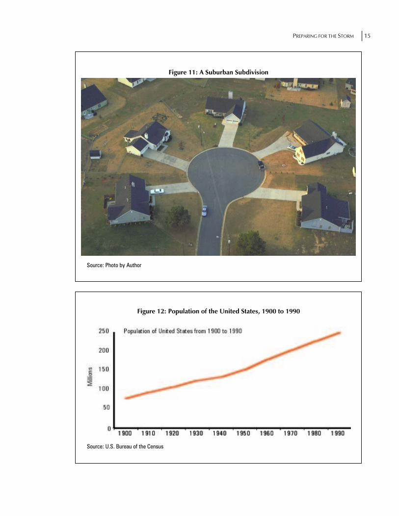
As Figure 11 shows, a suburban subdivision and associated roads can dominate the landscape, leaving little room for natural ecosystems that are part of the hydrologic cycle. Although no nationwide measurement of total imperviousness is available, its rate of increase warrants attention. Three trends underlie the increase in impervious surface area:
1. The U.S. population continues to grow at a rate of 20 million people per decade, a rate illustrated graphically in Figure 12. The increased population has been accommodated in housing with impervious rooftops. Assuming that housing has increased in proportion to the population since the turn of the century, this accounts for a 250 percent increase.
2. People have moved to cities where much of the surface area is paved, and concentrated runoff becomes a problem. As Figure 13 shows, the population was 40 percent urban at the start of the 20th century, increasing to 75 percent by the close of the century. In the South, where urbanization lagged behind the rest of the United States, the trend is even more striking.
3. Meanwhile, as Figure 14 illustrates, surfaced road-miles have increased 2,300 percent since 1900. The total increase in impervious surface in the 20th century is probably much greater, because many roads built after World War II are multilane roads, and parking lots have expanded to accommodate rapid growth in vehicular traffic.
PREPARING FOR THE STORM 15
Figure 11: A Suburban Subdivision
Source: Photo by Author
Figure 12: Population of the United States, 1900 to 1990
Source: U.S. Bureau of the Census

16 RPPI
Figure 13: Urban Population for Unites States and South, 1900 to 1990
Source: U.S. Bureau of the Census
Figure 14: Surfaced Road Miles – An Indicator of Imperviousness
Source: Compiled with U.S. Department of Commerce and U.S. Department of Transportation Data
Notes:
1. Data covers rural and urban road miles from 1904 to 1990.
2. Includes soil-surfaced roads as well as slag, gravel, stone, bituminous, or concrete surfaces.
3. Background photos for Figures 13 and 14 are from Nova Development Corporation (818) 591-9600, clip art CD Art Mania 12,000.
PREPARING FOR THE STORM 17
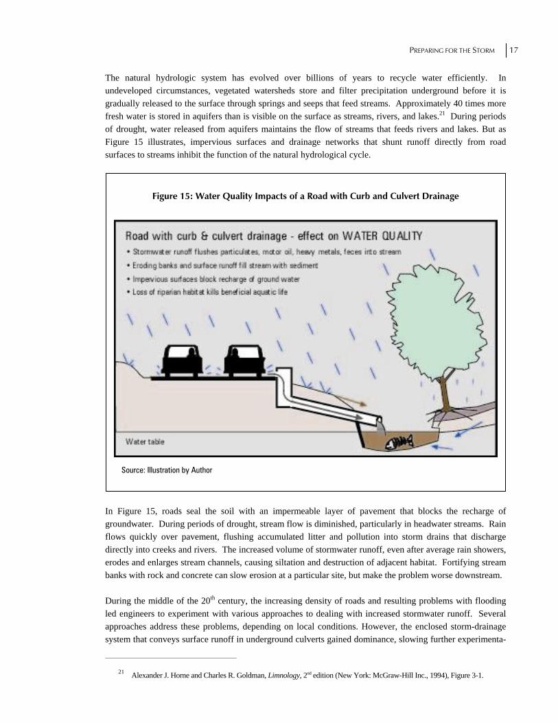
The natural hydrologic system has evolved over billions of years to recycle water efficiently. In undeveloped circumstances, vegetated watersheds store and filter precipitation underground before it is gradually released to the surface through springs and seeps that feed streams. Approximately 40 times more fresh water is stored in aquifers than is visible on the surface as streams, rivers, and lakes.21 During periods of drought, water released from aquifers maintains the flow of streams that feeds rivers and lakes. But as Figure 15 illustrates, impervious surfaces and drainage networks that shunt runoff directly from road surfaces to streams inhibit the function of the natural hydrological cycle.
Figure 15: Water Quality Impacts of a Road with Curb and Culvert Drainage
Source: Illustration by Author In Figure 15, roads seal the soil with an impermeable layer of pavement that blocks the recharge of groundwater. During periods of drought, stream flow is diminished, particularly in headwater streams. Rain flows quickly over pavement, flushing accumulated litter and pollution into storm drains that discharge directly into creeks and rivers. The increased volume of stormwater runoff, even after average rain showers, erodes and enlarges stream channels, causing siltation and destruction of adjacent habitat. Fortifying stream banks with rock and concrete can slow erosion at a particular site, but make the problem worse downstream. During the middle of the 20th century, the increasing density of roads and resulting problems with flooding led engineers to experiment with various approaches to dealing with increased stormwater runoff. Several approaches address these problems, depending on local conditions. However, the enclosed storm-drainage system that conveys surface runoff in underground culverts gained dominance, slowing further experimenta-
21 Alexander J. Horne and Charles R. Goldman, Limnology, 2nd edition (New York: McGraw-Hill Inc., 1994), Figure 3-1.

18 RPPI
tion for decades. Yet infrastructure managers discovered that speeding runoff from roads into creeks often caused flooding downstream. In an effort to reduce flooding, municipalities began requiring in the 1970s that developers install detention basins to hold back peak flow from major storms. Where the basin discharges through its outlet, the peak flow is reduced, but the downstream effect of detention depends upon how the basin’s discharge combines with the flow of other tributaries. In some watersheds, detention delays outflow from developed sites so that it overlaps onto the peak flow in the main stem, contributing to a higher combined flow.22 This problem with peak-flow detention was not foreseen, because the design standards were never tested for performance on a watershed basis, nor were the standards developed to protect streams or reduce pollution. The U.S. Geological Survey conducted a landmark study on the effects of urbanization on stream channels in suburban Washington, D.C. beginning in the early 1950s. It showed that a surge of sediment enters streams when land is opened for construction. Less recognized is the long-term effect of increased runoff from paved roads, rooftops, and parking lots. The increase in impermeable area results in an increased volume of runoff, which is rapidly conveyed by storm drains into streams. The development-induced surge of runoff from each storm erodes stream channels, draining the area, gradually enlarging the channels, and depositing sediment downstream.23 Over a period of 20 years the effect is dramatic. At the 25 to 30 percent impervious cover typical of many developed areas, stream channels experience two to five times stream channel enlargement.24 In addition to these effects of impervious surfaces, drainage networks dispose of stormwater as a waste product. Most of the pollutants that settle on the surface of roads wash off in a concentrated surge with the first flush of rainfall. With scouring, erosion, and pollution following every rain event, stream channels become biologically non-supporting extensions of the storm sewer system, requiring intensive treatment of water withdrawals for miles downstream. Since development is often concentrated along stream corridors, channel enlargement can result in extensive property damage. Cities face high costs as sanitary sewers and storm sewers are undermined by and leak into streams and rivers.25 Figure 16 graphically illustrates the destructive potential of development-induced stream channel enlargement. The problem is much more severe in older cities where sewer lines leak into storm drainage systems and streams. An indication of the extent of this problem is the growth of an industry that contracts with municipalities to line the interior of leaking sewer pipes. According to the president of one such company, Evanco Underground Services, “If a sewer line is over 25 years old, it is likely to be leaking.”26 In the past, cities dealt with problems of bank erosion and channel enlargement by burying headwater streams in underground culverts and constraining larger tributaries in concrete or stone-lined channels.
22 Bruce K. Ferguson, Introduction to Stormwater: Concept, Purpose, Design (New York: John Wiley & Sons, 1998), p. 162. 23 Luna B. Leopold, “A View of the River” (Cambridge Massachusetts: Harvard University Press, 1994), p. 165. 24 Caraco, Claytor, et al., Rapid Watershed Planning Handbook. 25 Alan Thomas, “U.S. Rehabilitation Projects, TV Inspection and Data Evaluation,” Journal of the International Society for
Trenchless Technology (August 1996), p.5. Obtaining cost estimates for infrastructure repairs, especially repairs to leaking sewer lines, is difficult since affected cities do not want to invite lawsuits by reporting on water pollution caused by leaking sewage. One city that did inspect its sewer lines is Houston, where 13 million feet of pipe was reportedly inspected utilizing 70-80 trucks operating remote-controlled TV cameras supplied by contractors from across the United States. At least half of the pipe that was inspected was scheduled for rehabilitation.
26 Telephone interview with Bruce Rau, President, Evanco Underground Services, Greenville South Carolina, www.evancous. com., August 12, 1999.

PREPARING FOR THE STORM 19
Some urban areas continue to bury and channelize streams despite widespread recognition that the practice worsens flooding and exports polluted water to communities downstream.
Figure 16: Destructive Potential of Development-Induced Stream Channel Enlargement
Source: Photo by Author
Pollution in urban streams is a very real problem. Point-source, or end-of-pipe discharges require a permit, but many illicit discharges from small pipes remain undetected. Surveys conducted through stream walks and storm sewer inspections can frequently uncover these illicit discharges and get them stopped through a program of enforcement. Numerous small or diffuse discharges are termed non-point pollution. Sources include particulate fallout from air pollution; fertilizers and pesticides applied to lawns; oil, antifreeze, and brake dust from vehicular traffic; pet feces on sidewalks and roadsides; and detergents and other chemicals from commercial activities. All of these substances are washed into streams by stormwater runoff. Chemical spills from industrial and commercial vehicle accidents can also discharge large quantities of pollution directly into storm drains that empty into streams. Effective stormwater management includes spill prevention and source-reduction programs that encourage proper disposal or recycling of potential pollutants. Though pollution remains a problem, it is important to look at the underlying conditions leading to urban water-quality impairment. Many of the point-source discharges from industrial sites have been greatly reduced through market-driven technological changes and requirements of the federal Clean Water Act. What remains are the far more numerous and harder-to-control nonpoint-sources of pollution. The greatest source of urban nonpoint pollution is runoff from impervious surfaces. Typically, three-fourths of the pollution loading in urban streams is from stormwater runoff. According to the Nationwide Urban Runoff

20 RPPI
study conducted by the EPA, the decline in urban stream health is best explained by a combination of altered hydrology and pollutant loading.27 In parts of some older cities, sewage and storm drains are combined; causing stormwater mixed with sewage to overflow as aging systems become overburdened. Figure 17 illustrates such a system.
Figure 17: Diagram Showing the Effect of Combined Sewer Overflow on Water Quality
Source: Diagram by Author In Figure 17, combined sewer systems mix stormwater and untreated sewage in the same system of collection pipes. During dry weather, sewage and small amounts of runoff entering the stormwater system (from car washing, for example) flow to the wastewater treatment plant. However, during wet weather, the capacity of the system is exceeded, and stormwater mixed with sewage overflows directly into creeks at points called Combined Sewer Overflows (CSOs). Combined sewers, leaking sewer lines, and illicit connections add to the problem of stormwater runoff. The organisms that inhabit a healthy stream can tolerate a certain amount of stress while the stream purifies itself of pollutants. The ability of streams to absorb low levels of pollution and recover is known as assimilative capacity. Certain organisms that colonize streams can actually break down pollutants into less harmful substances, in effect making the streams natural water-pollution treatment areas. This concept is used as a legal rationale for issuing effluent-discharge permits. Some discharge is permitted as long as enough miles of free-flowing stream or river exist below discharge points for water quality to return to
27 U.S. Environmental Protection Agency, Water Planning Division, Office of Water Program Operations, Office of Water,
Final Report of the Nationwide Urban Runoff Program (Washington, D.C.: 1983).

PREPARING FOR THE STORM 21
acceptable levels. However, when streams are stressed beyond their ability to adapt, either through excessive pollution loading, channelization, loss of riparian habitat, or changes in flow, assimilative capacity decreases, and the stream enters a spiral of decline.
D. The Economic Importance of the Hydrologic Cycle Is Ignored A root cause of current water problems is land-use development patterns and water-management systems that disrupt the Earth’s natural hydrological cycle. Solar energy powers this vast cycle that recharges aquifers, streams, and lakes. In Figure 18, solar energy powers the hydrologic cycle that recharges aquifers, streams, and lakes. The cycle operates through the interaction of physical and biological processes. Despite the abundance of water on Earth, very little is fresh. Water is distributed approximately as follows: oceans, 97.1 percent; ice, 2.25 percent; groundwater 0.6 percent; lakes (fresh and brackish) 0.015 percent; atmosphere, 0.001 percent; rivers, 0.0001 percent. The largest supply of fresh water is in the form of subsurface aquifers recharged through the process of infiltration of rainwater. But as Figure 19 illustrates, urban development that results in substantial impervious surface can disrupt the cycle by replacing complex ecosystems adapted to the efficient recycling of water with impervious rooftops and pavement. Impervious surfaces block the recharge of groundwater, causing rainfall to rapidly run off into streams. Keeping rain (stormwater) on the surface instead of letting it soak into the ground depletes groundwater supplies upon which many communities depend for drinking water. When groundwater recharge is blocked, water tables drop, contributing to springs and streams going dry in the summer. Impervious surfaces, especially roads, also accumulate pollutants that are washed off in a concentrated surge with the first flush of rainfall. Replacement of natural vegetation with pavement also markedly raises the summer temperature of cities, reducing personal comfort, increasing the use of air conditioning (which increases air pollution), and further damaging the natural system of water recycling.
Pollution in urban streams is a very real problem. Point-source, or end-of-pipe discharges require a permit, but many illicit discharges from small pipes remain undetected.
In Figure 19, urbanization alters all parts of the hydrologic balance. Urban development begins disrupting the hydrologic cycle by replacing complex ecosystems that have evolved to infiltrate precipitation into the ground where it is stored and gradually released, with impervious surfaces that block groundwater recharge and increase runoff. The engineered system of surface storage, created by damming streams and rivers, is losing capacity as sediment eroded by increased runoff fills reservoirs, shortening their useful life. The rapid runoff of stormwater into urban streams erodes their channels, causing the streams to deepen and widen. Stream-channel enlargement damages urban infrastructure by undermining bridges and sewer lines, collapsing structures, and eroding property. Increased runoff from impervious surfaces also results in an increase in damaging floods. Sediment eroded during the construction phase of new development, and later from enlarging stream channels, smothers aquatic life and accumulates downstream in water supply and flood-control reservoirs. The total cost of disruption to the hydrological cycle and resulting damage to urban infrastructure has not been calculated, but is likely to be very large.

22 RPPI
Figure 18: Earth’s Hydrologic Cycle
Source: Illustration by Author
Figure 19: Hydrologic Cycle Altered by Urban Development

PREPARING FOR THE STORM 23
Source: Illustrated by Author

24 RPPI
P a r t 2
Protecting Watersheds
hree main approaches have emerged for addressing the negative impacts of development dominated by impervious land surfaces:
The avoidance approach attempts to prevent development from happening by setting urban-growth boundaries, either through federal or state growth-management laws, or through local zoning codes. Outside the growth boundaries, development density is severely restricted; inside, additional develop-ment creates ever-higher densities.
The standard technocratic approach treats each development independently, using standard water-management techniques developed piecemeal to control stormwater without regard for the impacts that might affect the watershed as a whole.
A whole-watershed approach encourages cooperative management between public agencies and resource users within natural drainage basins. Community-based watershed initiatives springing up across the nation are creating demonstration projects for effective watershed management, but short-term funding through contributions and grants remains a major stumbling block to widespread adoption.
While the latter approach seems likely to produce the greatest level of surface-water protection, watershed management can in many cases benefit from long-term funding linked to infrastructure usage and user impacts on watershed health. One way to balance the need for a dynamic economy with the need to protect essential ecosystem “services” is to adopt user fees that reflect the costs of addressing stormwater runoff and pollution impacts. Urban development is often concentrated around rivers, lakes, wetlands, and coastal estuaries—areas that contribute most to the functioning of the hydrologic cycle. Fees that reflect such costs could discourage development of high-impact areas and could encourage development patterns that make better use of natural hydrological cycles. Unlike current funding of fragmented water utilities through tax revenue, user fees can create incentives to minimize harmful impacts and maintain development within the resource capacity of a given watershed. User fees create a positive feedback loop between costs and benefits. Compared to tax-based regulatory management, user-fee funding is more likely to be economically efficient and respond to the dynamic nature of both real estate markets and ecosystems. Moreover, user fee-funded utilities are less prone to political manipulation and better able to raise funds needed for long-term planning and maintenance. New federal requirements for stormwater permits affecting smaller cities and court-mandated enforcement of the Clean Water Act on a watershed basis are spurring many municipalities to consider the user-fee concept
T
PREPARING FOR THE STORM 25
for funding improved stormwater management. Over 350 stormwater utilities have been formed nationwide, most within the last decade.28 Widespread concern over the consequences of traditional engineering approaches to land development is leading to a search for alternatives. Public debate has focused on the issue of density. In a 1998 RPPI publication, The Sprawling of America: In Defense of the Dynamic City, Samuel Staley writes: “The debate over sprawl is driven primarily by general concern that low-density residential development threatens farmland and open space, increases public-service costs, encourages people and wealth to leave central cities, and degrades the environment.”29 Proponents of high-density development argue that concentrating development within urban-growth boundaries will leave surrounding open space for farms and protect environmental quality. Dozens of cities and counties have passed urban-growth boundaries to contain development. When the North American continent was settled, waterways served as the main avenues of commerce. In order to provide equal access and defensible boundaries, dividing lines for states, counties, and municipalities were drawn down the middle of rivers, streams, and lakes. Over time, the practice of dividing surface waters between competing jurisdictions likely encouraged depletion, pollution, and waste. Another impediment to watershed management is the regulatory overlap that has developed between agencies at all levels of government. At the federal level, water resources are addressed by a multitude of agencies including, among others, the U.S. Army Corps of Engineers, Bureau of Reclamation, Environmental Protection Agency, Federal Energy Regulatory Commission, Natural Resource Conservation Service, and the Fish and Wildlife Service. At the municipal level, water management is generally divided between separate departments for drinking water, roads and drainage, sewers, and parks and recreation. Fragmented management creates a need for interagency cooperation. In various places around the country, however, watershed resource-management initiatives seek to establish cooperative alliances between politically defined resource-management units based on state, county, municipal, tribal borders, or private property.30 Watershed-based ecosystem management replaces centralized one-size-fits-all decision making with more decentralized decisionmaking within natural drainage basins. The interdependence of watersheds with headwater tributaries feeding creeks, rivers, lakes, and estuaries makes watersheds the appropriate level of analysis for water resources. After all, political boundaries seldom coincide with watershed boundaries. A user-fee utility approach creates a context in which watershed management and impact costs become an integral part of development decision making. Market-based approaches can offer a superior alternative to regulatory prescriptions because they help foster private-sector innovation, they create incentives for developers to work with “nature,” and they provide revenue streams to fund needed infrastructure. Druid Hills, planned by landscape architect Frederick Law Olmsted, Sr., is instructive because, although it involved local land-use planning, the project was entirely a product of private enterprise. If it were conceived today, the same suburban design could not be built
28 Brant Keller, Director Public Works and Stormwater Department, city of Griffin, Georgia, interview with author, August 9, 1999.
29 Samuel R. Staley, The Sprawling of America: In Defense of the Dynamic City, Policy Study No. 251 (Los Angeles: Reason Public Policy Institute, 1999).
30 Michael Harrington and Christopher A. Hartwell, Rivers Among Us: Local Watershed Preservation and Resource Management in the Western United States, Policy Study No. 259 (Los Angeles: Reason Public Policy Institute, June 1999).

26 RPPI
because it conflicts with numerous zoning and stormwater codes imposed by local government. These same code provisions, dictating things like minimum-road widths and housing density, have been widely adopted throughout the nation. The result is that regulations intended to protect homebuyers from intrusive development have often had the unintended consequence of discouraging environmentally friendly designs adapted to local conditions.
A. Market-based Ecosystem Management Rather than adopting growth boundaries or other regulatory approaches that restrict development of broad areas of private land, a market-based approach to protecting surface waters that integrates economic and ecosystem needs could be implemented based on the following principles:
Implement cost-based user fees that equitably assign the cost of services with customers so those creating the greatest impact pay the highest fee. A user-fee-based stormwater utility could set charges based on the amount of impervious surface area. Stormwater utilities could also reduce fees for on-site stormwater control, superior pollutant control, and protection of sensitive areas such as wetlands. User fees give land developers, builders, and property owners an incentive to minimize environmental impacts. User fees can also pay for mitigation of the negative impacts of development. In addition, user fees can lessen dependence on property taxes, which weaken the linkage between costs and benefits.
Survey watersheds threatened with development to classify the land according to its ecosystem value. Stormwater utilities can fund the purchase of land with a high ecosystem value following the strategy of pollution prevention and could be less expensive and result in healthier communities than the alternative of controlling pollution through the construction of additional treatment plants.
Reward owners of environmentally sensitive property, such as wetlands and vegetated stream buffers, who minimize disturbance. This can be approached in three ways: reduced fees, reduced property taxes, and the purchase of conservation easements that confer tax benefits. The Bellevue stormwater utility has set an example by exempting private wetlands from stormwater fees. Property taxes represent a much larger expense to landowners; reducing or eliminating them on qualifying properties would have a much greater impact on landowner’s decisions, but changing local tax assessments can be difficult. A more practical approach is for stormwater utilities to fund the purchase of conservation easements from private landowners. A conservation easement is a deed restriction that allows the owner to maintain title while preventing further development or subdivision of ecologically valuable land. Conservation easements can also confer sizable tax benefits to the landowner. Where the ecosystem value of the land may not merit purchase, but there is still a need to reduce disturbance, private stewardship may provide a less costly and more flexible alternative.
• Phase out federal flood insurance for repeat claims and replace it with watershed-based flood management. Federal flood insurance was established to provide relief during disasters for markets that private insurers considered too risky. However, by paying property owners who repeatedly sustain flood damage, federal flood insurance has encouraged development on flood-prone, ecologically valuable land. The program should be phased out by paying people whose property has been flooded to move to less flood-prone areas.
• Make zoning and stormwater codes more flexible and effective by implementing performance-based measures tied to improvements in ecosystem health and reductions in flood damage. The adoption of flexible codes will represent a significant shift in how government agencies operate and will require the re-education of the review staff at most municipalities in the principles of adaptive

PREPARING FOR THE STORM 27
management. For such a proposal to be effective it is important that sound use of scientific information infuses performance-based measures. Lacey, Washington passed an ordinance aimed at limiting impervious surfaces by revising building codes, the first such ordinance in the United States.31
• Reduce wasteful administrative conflicts through comprehensive water-resource management at the local level by combining water supply, sanitary sewage, stormwater drainage and wildlife protection into an integrated water utility (privately managed or even privately owned).
• Address the issue of landscape fragmentation—the need for a connected network of riparian corridors—by finding private or private-public partnerships to support regional river-basin initiatives.32
• Improve service and control costs by contracting with private companies for services that cannot be performed efficiently by government.
Unlike current funding of fragmented water utilities through tax revenue, user fees can create incentives to minimize harmful impacts and maintain development within the resource capacity of a given watershed.
B. The Stormwater Utility Traditional stormwater management treats stormwater as a waste product of urban development.33 Responsibility for stormwater management is generally dispersed between various government agencies and departments, fragmenting stormwater management efforts and creating jurisdictional conflicts.34 Existing programs often suffer from inadequate funding, forcing managers to react to problems such as flooding with short-term, piecemeal solutions. Stormwater systems are rarely built to handle runoff from anticipated future development, often resulting in flooding and a loss of water quality to receiving waters. Citizen demand for an effective response to a crisis is credited for the formation of the stormwater utility concept. In Louisville, Kentucky the impetus for more effective stormwater management was a flood that inundated 60 percent of the city. In an effort to avoid a repeat of the disaster, a countywide drainage utility was established to consolidate local programs in 1986.35 In Tulsa, Oklahoma the precipitating event was a powerful thunderstorm that dumped 15 inches of rain on the city in 1984, killing 14 residents and destroying 80 city vehicles and pieces of equipment. Today, growing citizen demand for effective action dealing with
31 "Washington Towns Plan Test of Zone-Runoff Building Techniques," The Reinvention Report, Oct. 20, 1999. 32 For example, the Trust for Public Land and the Nature Conservancy has received a $25 million grant from the Woodruff
Foundation to purchase a corridor of land along the Chattahoochee River. However, to complete the project, federal and local governments may have to match the private funds.
33 Less well recognized is the role stormwater drainage plays in water pollution from agricultural fields. Drained wetlands and flood plain fields are often underlain by a system of underground pipes and separated by ditches. Those drainage systems discharge runoff loaded with fertilizers and pesticides directly into surface waters.
34 Hector J. Cyre, President, Water Resource Associates Inc., presentation at Sustainable Development Conference, The Civic Center, Atlanta, GA, August 20, 1999.
35 G.R. Garner, et al., User-Fee-Funded Stormwater Utility (Marietta, Georgia: Ogden Corporation, May 1997).

28 RPPI
environmental problems related to urban infrastructure is prompting many more communities to consider the stormwater utility concept illustrated in Figure 20.
Figure 20: Virtuous Cycle of the Stormwater Utility
Source: Illustration by Author Some officials may initially be uncomfortable with the stormwater utility concept because it relies on a feedback mechanism rather than a linear planning process. However, the complex, changing nature of environmental systems makes them ill suited to traditional management, leading to failure and frustration. Many experts, including the EPA, are recommending adaptive management that is responsive to the dynamic nature of both markets and ecosystems. Adaptive management is a process for improving resource management incrementally as managers and scientists learn from new experience and scientific findings. Formation of a stormwater utility begins with the development of a strategy for improving service and proceeds with programs to finance the basic mission and collect data on all aspects of the system, including impacts. Development of a utility generally requires three parallel tracks of activity. These include: 1) a program track, 2) a finance track, and 3) a database track. Development of a user-fee rate structure is an iterative process. Desired improvements defined under the program track translate into a rate structure through the finance track, which in turn requires information generated through the database track. A feedback loop between the tracks indicates when the desired rate structure is too expensive to develop or maintain or the data are insufficient to support it.36 Affordable consulting services are available for setting up and managing a stormwater utility.
36 Andrew J. Reese, Steps in the Development of a Stormwater Utility (Marietta, Georgia: Ogden Corporation, May 1997).

PREPARING FOR THE STORM 29
A key element of the stormwater utility concept is the development of a database that enables managers to overlay complex features of the built and natural environments. Geographic Information Systems (GIS), store layers of data on topography, vegetation, hydrology, geology, property parcels, roads, sewer lines, and drainage systems, and register the data on a common cartographic coordinate system.
Figure 21: Geographic Information Systems
Source: Adapted by Author from an illustration by Edward O. Wilson in The Diversity of Life (Boston, Mass: Harvard University Press, 1992).
In Figure 21, Geographic Information Systems combine information on human, physical, and biological environments by joining layered electronic data sets. GIS offers a tool for managing the landscape in a way that protects both property rights and ecosystems. For billing purposes, managers can use the system to calculate impervious surface area from aerial photographs overlaid with individual property parcels. They can also tag stream-monitoring results obtained in the field to specific map locations or calculate the potential for flooding created by a proposed

30 RPPI
development site. Technology now makes it much easier to work with nature. A stormwater utility can fund the application of GIS technology at the local level. The user-fee-funded stormwater utility provides functional recognition of stormwater as a resource. The utility concept focuses management in a single organization, which can be public, private, or some combination thereof. Creation of a utility allows for dedicated infrastructure and management funding, with fees tied to impacts. The approach enables development of comprehensive preventative and enhancement programs.37 Stormwater runoff in already-developed communities has been successfully treated by retrofitting ponds into low places in the terrain. One such project, on Weaton Branch in suburban Maryland north of Washington, D.C., has improved the health of a stream impacted by run off from a shopping mall. There, a group of ponds was designed to intercept runoff before entering a near-by stream.
Figure 22: Stormwater Pond on Weaton Branch
Source: Photo by Author
This stormwater pond on Weaton Branch, north of Washington D.C., controls runoff from a highly impervious area surrounding a shopping mall. The pond is designed to deepen following a rainfall, then slowly release the detained water over a two-day period. Stormwater facilities built to work with nature can become neighborhood amenities. In a typical pond, the outfall structure is designed so that it holds a pool of permanent water. During rainstorms, additional stormwater accumulates in the pond. The outfall structure then gradually releases the
37 Cyre, presentation at Sustainable Development Conference.

PREPARING FOR THE STORM 31
stored water into a receiving stream. This design combines two techniques, retention of a permanent pool, with extended detention of stormflow. By supporting a permanent, balanced ecosystem, insect pests are controlled while at the same time treating the first flush of runoff. Other design features that improve the effectiveness of stormwater ponds include forebays that capture sediment and trash, fringing wetlands, and a bordering canopy of trees.
Many municipalities currently require developers to install peak-flow detention basins. In some areas of the country these older facilities with limited effectiveness can be converted for extended detention of stormwater. Extended detention impounds stormwater, then gradually releases it over a period of one to three days. When combined with tree planting and stream-bank stabilization, this approach has the potential to improve water quality in existing communities that have limited space for more natural stormwater controls.
The user-fee-funded stormwater utility provides functional recognition of stormwater as a resource.
Structural stormwater controls that mimic natural systems are only part of the response to restoring streams and healthy communities. One of the most important steps is urban reforestation. However, far too many cities consider a token planting of trees within small holes cut into the pavement to be urban reforestation. In order to mature, trees generally need planting strips between paved areas eight-feet wide. The approach taken by urban planner Frederick Law Olmsted in Druid Hills, where homes and roads were constructed without knocking the forest down, offers an even more desirable alternative. A forest is an evolved ecosystem including permeable topsoil that functions as part of the hydrologic cycle. Restoring an urban forest means planting a variety of tree species that support wildlife, such as insectivorous birds. Within the aquatic environment, roots stabilize stream banks, while leaves and organic matter shed by trees adjacent to the stream form an integral part of the aquatic food chain. In addition to numerous other benefits, such as lowering air-conditioning costs and attenuating urban noise, restoring a canopy of trees reduces stormwater runoff by intercepting up to a quarter-inch of rainfall before it hits the pavement. One of the success stories of pollution control at the federal level is a reduction in the use of toxic heavy metals. The Nationwide Urban Runoff Program (NURP), a comprehensive set of studies conducted by the EPA on the causes of urban water pollution, identified heavy metals as the priority pollutants of greatest concern.38 Heavy metals washed into stormwater eventually enter water supplies of communities downstream. Heavy metals are a particular hazard because they persist in the environment for a long time and accumulate in greater concentrations in shellfish that feed by filtering particles from the water and in predators, such as fish, near the top of the food chain. The heavy metal of greatest concern in the 1983 Nationwide Urban Runoff Studies was lead. Lead accumulates on pavement as fallout from air pollution and leaches from painted surfaces. Rainfall flushes accumulated lead particles into stormwater entering aquatic systems. By 1988, regulation by the EPA had almost eliminated lead from paint and gasoline. Subsequently, the concentration of lead in the environment
38 U.S. Environmental Protection Agency, Water Planning Division, Office of Water Program Operations, Office of Water,
Final Report of the Nationwide Urban Runoff Program (Washington, D.C.: 1983).

32 RPPI
has dropped by 89 percent. Use of lead was reduced after medical research established severe developmental consequences, particularly mental retardation in small children.39 Although NURP focused on chemical contamination as a cause of poor water quality, a major finding of the study was that loss of habitat from the physical impact of stormwater-induced erosion and sedimentation often had a more deleterious effect on water quality than chemical contamination. Subsequent studies linked the amount of impervious surface area in a watershed to altered hydrology and the cascade of secondary effects including stream bank erosion, sedimentation, and pollutant transport. Stormwater utilities are well suited to addressing the major cause of water quality impairment at the local watershed level.
39 Tom Tietenberg, Environmental and Natural Resource Economics (New York, NY: Harper Collins Publishers, 1992), p. 455,
469.

PREPARING FOR THE STORM 33
P a r t 3
Key Policy Challenges
n considering development of water utilities, several environmental and logistical challenges warrant attention. These include challenges of addressing interstate and interregional issues, the importance of moving toward a systemwide approach, and the distinctive aspects of stormwater relative to sewage and other “wastes.”
A. Taking a Watershed View To be fully effective, watershed protection should begin in the headwaters and progress downstream. Protecting water at its source is often preferable to removing pollution once it enters a water supply. In practice, this requires local, decentralized decisionmaking. The EPA has estimated that over 3.5 million miles of streams and rivers exist in the United States.40 Given the enormity and complexity of the task, keeping America’s waters healthy will require a local effort. Contrary to popular perception, headwaters of a river are not simply in some distant place in the mountains where a particular spring bubbles up from the ground. This view derives in part from famous stories of explorers searching for the source of great rivers in unknown places. In reality, as Figure 23 illustrates, tributary streams typically originate all along the divide of high ground that rims a watershed and separates it from other adjacent watersheds. The example used is for the Apalachicola-Chattahoochee-Flint (ACF) River Basin, site of a major legal dispute that will be discussed shortly in a case study of Metropolitan Atlanta. The ACF System supplies water to, and receives waste from, large areas of Georgia, Alabama, and Florida. Although the system first begins flowing in the mountains of North Georgia, all of the tributary streams contribute to the system’s flow, including the highly impervious watersheds draining urbanized Atlanta. In Figure 23, watersheds nest one inside another as illustrated by this set of watersheds from a case study of Atlanta. Large watersheds drained by rivers or river systems are called basins. Tributaries within a larger watershed are usually called subwatersheds. Although the size of watersheds roughly corresponds to that of political jurisdictions from the state down to the county and municipal level, the boundaries rarely coincide, greatly complicating management.
40 U.S. Environmental Protection Agency, The Quality of Our Nation’s Water (Washington, D.C., Document EPA841-s-97-001, April 1998), p. 7.
I

34 RPPI
Figure 23: Watershed Management Units vs. Political Jurisdictions
Source: Illustration by Author A river system has a branching pattern much like a tree; there is usually one main trunk with dozens of branches and thousands of twigs. Each of the twigs is equivalent to a small headwater stream with its own small sub-watershed nested inside a branch tributary watershed, which is nested in turn inside the main river basin. In terms of watershed management, this means that protecting water at its source will necessarily involve many individuals and communities protecting small streams throughout the watershed. Watershed protection beginning in the headwaters not only improves water quality for others downstream, it also makes the communities themselves better places to live. Ideally, river basin management should be combined with management at the local watershed level (as discussed later, regarding Florida’s Water Management Districts). Headwater streams are emphasized here because the predominant technocratic approach to water management relies on the construction of large public works projects to store, filter, and regulate the flow of water downstream when it could be more cost effective and ecologically sound to first protect water at its source. Previous generations could generally count on streams to purify themselves as they flowed through the countryside. With high levels of imperviousness now covering many regions of the United States, polluted streams never have a chance to recover. User-fee-funded stormwater utilities provide a way to fund watershed improvements that offset runoff and pollution accompanying population growth.

PREPARING FOR THE STORM 35
B. Disentangling Stormwater Management from Sewage Treatment Stormwater is fundamentally different than sewage. Treating sewage in treatment plants is often effective and efficient. Except for densely developed urban centers and certain toxic sites, treating stormwater in treatment plants is inefficient and hard to justify. Sewage is a concentrated effluent that flows constantly from collection pipes. Sewage-treatment plants use cultures of bacteria that digest human waste in giant tanks. To a great extent, sewage treatment is a biological process concentrated in a small space using pumps and aeration to keep bacteria working at a high level of efficiency. By contrast, stormwater runoff is very dilute, but there is much more of it. Unlike sewage, the volume, composition, and temperature of stormwater change radically over time. Since stormwater flow varies from almost none during dry weather to a sudden flood following a rainstorm, building enough treatment-plant capacity to remove the contamination contained in even the first flush of runoff becomes prohibitively expensive. An alternative is to restore the hydrologic cycle that recycles water by controlling runoff from impervious surfaces and reducing pollution at its source. This means either reducing the amount of impervious surface area below 10 percent (impractical in most urban areas) or treating runoff by infiltrating it in the ground and detaining it in ponds and wetlands for an extended period of time. This approach of designing drainage systems to work with nature is often termed bioengineering. Pollution reduction and spill prevention programs can be combined with bioengineering to reduce polluting materials at the source (source reduction). By protecting the natural assimilative capacity of groundwater recharge zones, streams, rivers, lakes, and estuaries, the small amount of pollution that does escape can be broken down by microorganisms in the soil or in the aquatic environment.
C. Obtaining Interstate Cooperation One of the limitations of any watershed management effort is that most river basins flow between states. Consider North Florida, which shares river basins with the neighboring states of Georgia and Alabama. A river system flowing between the states has great importance to the regional economy. Known as the Apalachicola-Chattahoochee-Flint (ACF) River Basin, the system originates in North Georgia, where it supplies water to, and is greatly influenced by runoff from, Metropolitan Atlanta. As Figure 24 illustrates, after passing through Atlanta, the Chattahoochee (the longest river in the system) forms the border between Georgia and Alabama. The river system is vitally important to the economy of North Florida because, following the decline in the health of Chesapeake Bay, it feeds the most-productive seafood estuary on the entire East Coast. Interspersed throughout the ACF System are 15 major dams that back up the rivers into a series of reservoirs. Flows within the system are managed through water releases controlled by the United States Army Corps of Engineers. The protracted legal battle known regionally as the “water wars” began over Atlanta’s demand for additional water from rivers shared with Alabama and Florida. The battle began in the drought years of the 1980s when Atlanta faced serious water shortages, leading to conflicts over the allocation of limited supplies from the Chattahoochee and other rivers. The conflicts came to a head in 1990 when the State of Alabama sued the Army Corps of Engineers in federal court to block the allocation of additional water to municipalities within the Metro Atlanta region. When Florida joined the dispute, the press dubbed it the “tri-state water wars.” The suit was prompted by a plan pushed by the Atlanta Regional Commission to double Metropolitan

36 RPPI
Atlanta’s permitted withdrawals by the year 2010. Atlanta leaders believed the water was needed to meet residential and industrial growth.41 In 1992, the disputing parties reached an agreement to stay the suit pending an ongoing $13.5 million comprehensive study of water demands, resources, and management strategy. Currently, the parties are continuing to negotiate in order to avoid having the case go to the U.S. Supreme Court. The “tri-state water war” is being fought over the quantity of water allocated from a finite natural resource. According to U.S. Rep. Bob Barr (R-Ga.), “It would be one of the most complex cases ever before the court. It could be tied up in the court for years, and the court could put a moratorium on new uses of water, the economic loss to Georgia could be in the billions of dollars.”42 Additional, separate disputes underway involve issues affecting water quality. amenable
Figure 24: Water Management in the ACF Drainage Basin
Source: Illustration by Author, Data from U.S. Army Corps of Engineers 1996 (www.nacc.usgcrp.gov/sectors/ water/draft-report/figure3.html#Figure3), Photo courtesy of United States Geologic Survey, Atlanta Office.
The water wars and other lawsuits reveal the difficulties of resolving resource conflicts through adversarial means. Eugene Odum, often referred to as the father of ecosystem ecology, has pointed out that when resources are abundant, competition between species is a winning strategy. However, as ecosystems mature
41 Robert Montgomery, Living Waters: A Special Report on an American River for Clean Water Inc. (Montgomery Alabama:
B.A.S.S. Inc., 1991). 42 Quoted in Charles Seabrook, “Tri-State Water War Rages Again,” The Atlanta Journal-Constitution, May 24, 1999, p. E2.
PREPARING FOR THE STORM 37
and resources become limited, cooperation provides species with an adaptive advantage.43 Use of market institutions also provides a means of avoiding conflict by effectively allocating and managing scarce resources.
D. Fostering Community-based Watershed Protection In other parts of the nation, local communities are spearheading watershed protection efforts. People are more likely to take action and make sacrifices to protect a local stream or lake than they are to embrace an abstract idea such as environmental protection. Hydrologic and ecological interactions over a large scale suggest that watershed programs should proceed at the scale of river basins. However, watershed programs on a broad, regional scale face significant political and institutional barriers. The larger the watershed, the greater the challenges in coordinating multiple individuals and municipal, county, state, and federal agencies. Large-scale programs risk opposition from local government officials who fear loss of control over land use, economic, or environmental policies. In contrast, local politicians who ignore community-based watershed-protection efforts risk being replaced in the next election. Watershed programs initiated out of Washington, D.C. are almost certain to arouse local suspicions; locally initiated programs are less threatening, and they enable decision makers to tap into the “local knowledge” of those that own or use the relevant water and land resources. The hydrologic cycle is a matrix of interlinked components consisting of headwater catchments nested within larger-scale watersheds and river basins connected by a continuous stream of flowing water. The cycle, a complex, adaptive system, operates without central control, not unlike the distributed system of computers that form the Internet and move streams of information. Like the Internet, the emergence of community-based watershed initiatives springing up across the nation represents a new phenomenon based on citizen response to local needs and conditions. Given the opportunity, local watershed groups may organize over time into larger-scale networks more closely aligned with regional resource boundaries. Community-based watershed initiatives are already creating demonstration projects for effective watershed management. Unlike narrowly focused regulatory management, which levies sanctions for noncompliance, watershed initiatives emphasize flexibility, problem solving, and a balancing of competing interests and goals. To date, community groups have been funded mainly by a combination of short-term government and private grants.44 Where watershed boundaries closely approximate political boundaries, local governments have also participated in watershed initiatives funded by a combination of grants and tax revenue. Water withdrawal and discharge permit fees could provide funding for state planning and enforcement at the river basin level. Unlike taxes, water use fees can be made proportional to management costs and impacts. To achieve its potential, long-term funding for watershed management should establish positive feedback loops that link user impacts to watershed health. The next section describes such a program for dedicated, long-term funding of watershed management that grew out of a community-based effort and is now being expanded to encompass comprehensive water-resource management at the countywide level.
43 Eugene P. Odum, How to Prosper in a World of Limited Resources (Atlanta, Georgia: University of Georgia, transcript of the
1990 Ferdinand Phinizy Lecture, 1991). 44 Harrington and Hartwell, Rivers Among Us.
38 RPPI
P a r t 4
New Market Approaches in Action
A. Bellevue, Washington: User Fees Tied to Impervious Surface Bellevue, Washington has adopted the type of feedback-loop approach described above.45 Concerned that land development was destroying the very qualities that attracted residents to the city, some citizens worked with their local government to study the problem. They identified stormwater runoff from impervious surfaces and loss of ecosystem function as key problems. Because the city’s political boundary nearly coincided with the natural watersheds, Bellevue was able to address the problems locally. In 1974, the city established a cost-based, user-fee-funded stormwater utility. The utility applied fees that charged property owners based on the amount of impervious surface. An advanced Geographic Information System (GIS) is now utilized for ecosystem management that overlays elements of the built environment (such as property parcels) with elements of the natural environment (such as wetlands). Despite one of the highest fee structures in the nation, property values and approval ratings for the utility remain high because the fees are linked to specific watershed management and impact-abatement needs. Many consider Bellevue to be an urban oasis where tree-shaded streams still support trout, flood damage is minimal, and surface streets remain relatively uncongested. Bellevue’s stormwater utility has been elevated to department status and is now cooperating with surrounding King County for more comprehensive water-resource management that will combine water supply, sanitary sewage, stormwater drainage, and wildlife protection. Bellevue is a suburb of Seattle located between the shores of Lake Washington and Lake Sammamish.46 In addition to rediscovering the linkage between watershed protection and a healthy community, the city developed an institutional framework for maintaining the integrity of the system over time. Bellevue enacted one of the first user-fee-funded stormwater utilities in the nation. Unlike most stormwater utilities formed to deal with flooding, Bellevue’s program was the result of citizen concern over the impacts of emerging land-development patterns. The city council appointed several of the citizens to a committee to examine the problem. Initially, the committee examined erosion and sedimentation resulting from development practices that damaged stream channels used by spawning salmon. Recognizing that stormwater was causing the erosion, the committee recommended that the city establish both an erosion-control ordinance and a stormwater-management program. At the same time, the state of
45 Site visit by author in 1997, Utilities Department, City of Bellevue, Washington. 46 Bellevue has a population of 110,000. The utility department has determined that most of the city exceeds 30 percent
imperviousness.

PREPARING FOR THE STORM 39
Washington passed an amendment to existing legislation permitting stormwater management to be funded using a system of cost-based user fees. Acting on the committee’s recommendation, the Bellevue City Council established a stormwater utility in 1974 as a division of the Department of Public Works. The mission of the drainage utility was to “manage the storm and surface water system of Bellevue, to maintain a hydrologic balance, to prevent property damage, and to protect water quality; for the safety and enjoyment of citizens and the preservation and enhancement of wildlife habitat.” The service charge is based on a graduated scale for the size of the property measured in square feet and the amount of development determined by percent impervious surface. A “very heavily developed” property is assessed about three times more than an “undeveloped” property of the same size. There is no charge for wetlands.47 A typical residential homeowner pays about $100 per year.48 As the city improves its GIS mapping and data-retrieval system, it plans to refine the graduated fee structure to better reflect impacts. Unlike taxes, which exempt government, user fees treat government property the same as private property. Moreover, the fees are tied to the costs of watershed management and impacts associated with individual properties.
Figure 25: Private Berry Growers Show Off Their Crop
Source: Photo by Author
47 City of Bellevue Ordinance No. 5115. 48 Rick Watson, Operations Manager, Utilities Department, Environmental Division, Bellevue Washington, interview with
author, August 3, 1999. This is the portion of the total utilities bill attributable to stormwater.

40 RPPI
Using the collected fees, the utility began an aggressive maintenance program to catch up with neglected repairs and began acquiring key properties deemed important for the protection of water quality and wildlife habitat. Over time, hundreds of small-scale neighborhood-control facilities were constructed to moderate and cleanse stormwater runoff from impervious surfaces. These facilities resemble ponds and temporary wetlands. Figure 25 shows a seasonal wetland acquired by the stormwater utility that was leased to a private farmer for blueberry production. By minimizing pesticide applications, the wetland does double-duty growing berries and enhancing water quality. Residents can pay a small fee to pick their own berries or buy them by the quart. Despite its rural appearance, the farm and wetland are surrounded by urban Bellevue. The wetland is a successful example of private management of public land. Public information programs featured previously unnoticed streams winding through the town. Visitors to Bellevue immediately notice that city streams are identified by signs—like the one in Figure 26—just like city streets signs.
A demonstration project was begun featuring stream protection in cooperation with local citizens and state agencies. As the environ-mental orientation of the program grew, schools incorporated stream monitoring into their curriculum of study. Since its founding, the Bellevue program has evolved to adopt a watershed approach that combines controls on runoff from impervious surfaces with protection of the natural drainage system of streams and wetlands. Maintenance practices have been altered to emphasize prevention. Despite the urban character of the community, water quality remains high enough to support several species of salmon and trout. Recent storms have proven the value of stormwater controls, stream protection, and wetlands in preventing property damage from flooding. The stormwater utility was eventually elevated to department status and is now cooperating with surrounding King County to apply a watershed approach to comprehensive water-resource management. Bellevue’s program is innovative because it uses a rate structure that charges property owners in proportion to the impact of individual developments on the health of the natural hydrologic cycle. Like other systems
Figure 26: Signage Identifies Vulnerable Waterways in Bellevue
Source: Photo by Author

PREPARING FOR THE STORM 41
in nature, the hydrologic cycle is dynamic, adapting to change through feedback loops that work to restore equilibrium. The user-fee rate structure establishes a feedback loop between impacts on the natural system, as measured through impervious surface area and uncontrolled runoff. Performance is measured by evaluating stormwater damage to property and the health of the aquatic system. In other cities, stormwater services are typically combined with road maintenance and funded from property taxes or general revenue. Repairs are usually performed on a piecemeal basis as a second priority to the department’s main responsibility of building and maintaining roads. Responsibility for regulating development and drainage is often divided between different departments and political jurisdictions with the result that drainage systems become overburdened with increased flow as areas develop. The result is often crisis management as aging systems collapse, and erosion and floods destroy property. The user fee charged by stormwater utilities provides an incentive for better long-term maintenance. When property damage occurs due to flooding, ratepayers in Bellevue know where to call for service. Unlike general tax revenues that can be reappropriated based on political whim, user fees must be spent for a designated purpose. In 1998 Bellevue hired a private contractor to conduct a performance survey of its utility customers.49 Despite one of the highest service fees in the nation, the ratings were favorable. The highest overall complaint with utility service (including water, sewer, garbage/recycling, drainage, and wildlife) was 9 percent of respondents saying fees were too high. When asked to rate the protection of fish and other wildlife, 44 percent of respondents said that the utility should do more even if that meant higher bills. The Bellevue Drainage Service was rated by 66 percent as good or excellent; 23 percent were neutral or “didn’t know,” while 12 percent rated the service as poor or very poor. Bellevue’s location was ideal for the establishment of a stormwater utility, because the city’s political boundary closely coincides with the natural watersheds that drain it. Sandwiched between two lakes, the short streams in Bellevue drain directly into receiving bodies valued by city residents for multiple uses including recreation and scenic views. Discharges entering a city stream quickly end up in a lake valued by residents, making watershed protection a high priority.
B. Charlotte: User Fees, Rewards, and Private Contracting Charlotte, North Carolina’s experience demonstrates that it is possible to retrofit stormwater controls to already developed neighborhoods through bioengineering of retention ponds, stream-habitat improvements, and other measures. Charlotte and surrounding Mecklenberg County jointly manage stormwater services utilizing an advanced GIS system that can be accessed by citizens through an internet web site.50 Charlotte employs a user-fee based stormwater utility and has applied many of the techniques learned in Bellevue but adapted to local conditions. Unlike Bellevue, which began protecting streams before the city was densely developed, Charlotte’s drainage system was badly neglected and its streams were impaired when the utility was established in 1993. The city is now in the process of catching up with maintenance while initiating a stream rehabilitation plan that includes testing and water-quality modeling, rehabilitation of eroded stream
49 GMA Research Corp., “Bellevue Utilities Performance Measurement Survey: Summary Report,” prepared for City of Bellevue Department of Planning and Community Development (Washington: Bellevue: July 1998).
50 www.co.mecklenberg.nc.us/cogis/overview.htm.

42 RPPI
channels, protection of stream buffers, and retrofitting of stormwater-control ponds. Charlotte requires that developers of new subdivisions keep construction out of stream buffers and rewards those developers who exceed minimum land-use performance standards through a program of density credits. Charlotte controls costs while maintaining quality by contracting with private companies for almost all the utility’s operations and maintenance requirements.51
C. Atlanta: When Is a Fee a Tax? Metropolitan Atlanta has rapidly developed with minimal control of stormwater or protection of ecologically significant natural areas. Thus, Olmsted’s design is a rare exception to Atlanta’s current pattern of development. As recently as 20 years ago, residents of Atlanta proudly proclaimed their hometown to be an urban forest. Today, Metro Atlanta’s average driving distance is the longest in the nation, as the area has experienced substantial development over broad areas.52 Summer temperatures measured downtown and at the airport have risen 6-12 °F over the past two decades, as compared to surrounding forested countryside.53 The city has faced one of the largest fines ever assessed under the Clean Water Act.54 In contrast to Bellevue’s and Charlotte’s successes in forming stormwater utilities, Atlanta provides an example of how not to form a stormwater utility. Created in 1999, Atlanta’s new stormwater utility was overturned in court months after its creation. The court found that the utility was funded by a tax disguised as a user fee. A true user fee is dedicated to specific improvements whereas Atlanta’s fee was found to be similar to a tax used for general purposes. Atlanta’s situation exemplifies the severe water problems of a rapidly growing metropolitan area in the rainy Southeast.55 Unlike a number of other cities in the United States, Atlanta has no geographic barriers to expansion. However, a finite supply of clean water is looming as a barrier to future development. Atlanta is at the center of a bitter water war with neighboring states over water rights. A series of legal battles have also been fought over deteriorating water quality. One reason for Atlanta’s water woes is that the city is located inland, relatively close to the headwaters of the Chattahoochee River, its major supply river. Development along tributary streams is impairing the health of the river. Like a number of other cities, Atlanta obtains its water from upstream reservoirs that are being silted up and polluted. Even larger loadings of urban runoff and an overburdened sewage system are contaminating reservoirs downstream from Atlanta. A watershed study funded by the city showed that stormwater runoff and alterations in stream hydrology are responsible for three-fourths of the pollution loading. The same study found that almost all of Atlanta’s streams were biologically impaired.56 In past years Atlanta ignored its impact on downstream water users until state and federal fines forced it to act. Thus far, the city’s response has been a
51 Interview with Jeb Blackwell, Division Head, Engineering and Property Management, Stormwater Services, Charlotte, North Carolina, August 13, 1999.
52 Daniel Pedersen, Vern E. Smith, and Jerry Adler, “Sprawling, Sprawling,” Newsweek, July 19, 1999, p. 26. 53 Charles Seabrook, “Scalping of the Land Makes Atlantans Hot: Satellite data show rapid clear-cutting,” The Atlanta Journal-
Constitution, February 19, 1999, p. 1. 54 Julie B. Harrison, “Atlanta Will Pay Larger Pollution Fine,” The Atlanta Journal-Constitution, July 30, 1999, p. D1. 55 Metro Atlanta has a population of three million and receives approximately 50 inches of rainfall per year. 56 City of Atlanta Department of Public Works Division of Wastewater Services, Impacts Assessment (East & West Watersheds),
Metro Atlanta Urban Watersheds Initiative (Atlanta Georgia: CH2M Hill Corporation, September 1998).

PREPARING FOR THE STORM 43
narrow focus on controlling stormwater pollution through the construction of treatment plants, while largely ignoring evidence on the multiple benefits of pollution prevention through watershed protection.
Figure 27: One of Atlanta’s Stormwater Treatment Plants
Source: Photo by Author Figure 27 shows a technocratic approach to water management. A stormwater treatment facility under construction in Piedmont Park in Atlanta uses mechanical screens to remove coarse debris and chlorination to kill bacteria. The photograph in Figure 27 shows Clear Creek being buried in a box culvert. A subsequent analysis by the EPA questioned the plant’s effectiveness. Facing increasing pressure to clean up its rivers and streams, Atlanta began the Metro Atlanta Urban Watersheds Initiative (MAUWI) in early 1996. The goals of the initiative were to: 1) determine the current conditions of creeks and rivers, 2) identify the source and effects of pollutants on the health of waterways, and 3) devise a plan for improving water quality. A community-based committee of watershed stakeholders was appointed to guide the process. In late 1998 consultants performing the MAUWI studies issued their report containing the following conclusions:
Almost all of Atlanta’s streams were moderately to severely impaired;
The main cause of both biotic and nonbiotic stream impairment was altered hydrology resulting from high levels of impervious surface;
Stormwater contributed approximately three-fourths of the pollutant loading in Atlanta streams.57
57 Ibid.

44 RPPI
The initiative also estimated the costs to improve the health of Atlanta’s streams and provided initial discussions on the concept of a stormwater utility. The citizen-based steering committee recommended continuation of the watershed program, but funding was not renewed, and the program was terminated. In January 1999, the City of Atlanta initiated a stormwater utility when it began sending out bills to property owners. Unlike Bellevue, which charges a user fee based on impervious surface area, Atlanta’s stormwater utility calculated its charge based on the square footage and use of each property. Three months later, in response to a suit filed by the Fulton County Taxpayers Association, a Fulton County judge ordered Atlanta to stop collecting stormwater fees and to return more than $3 million already collected. In September, Atlanta’s stormwater utility was overturned in court because it is similar to a tax used to raise money for general purposes. The city did not satisfy the court that the funds were dedicated to stormwater and water quality improvements.58 A successful cost-based, user-fee-funded stormwater utility in the City of Griffin, just south of Atlanta, has established a legal precedent and has demonstrated that the concept will work in Georgia if the user-fee is applied to dedicated funding of stormwater improvements. When forming a cost-based, user-fee-funded stormwater utility, citizen involvement is essential. Atlanta began appropriately enough by funding a watershed initiative with citizen involvement but then disbanded the effort, creating mistrust. Rather than charge fees based on actual costs of watershed management and impacts, the city implemented a fee structure that was never adequately explained. Rather than use a system open to public review, the fee structure was suspected of funding unrelated politically favored projects. The Fulton County Taxpayers Association introduced documents in court showing that the “fee” would collect almost $10 million instead of $2 million per year projected by the city. 59 Despite the overwhelming need for stormwater improvement, officials could not account for where millions of dollars would be spent.
D. Druid Hills, Atlanta: A Market-inspired Alternative In Atlanta, an area designed at the turn-of-the-century by the great landscape architect Frederick Law Olmsted, Jr. shows how an attractive, economically successful suburban community can be designed to work with nature. This pioneering subdivision, commissioned by innovative Atlanta developer Joel Hurt, was conceived as an “ideal residential suburb.”60 Druid Hills incorporates features for controlling stormwater, protecting stream buffers, and avoiding disturbance to the land. Early in his career, Olmsted developed closed storm drains for conveying runoff directly from streets to rivers. Druid Hills, Olmsted’s last great work, incorporated elements gained from Olmsted’s years of experience. Olmsted designed an advanced system of drainage that integrated well with the natural environment. A century old, Druid Hills is a unique showcase for ecologically sound design, demonstrating that watershed protection can create a desirable neighborhood with high property values. As the debate over environmental impacts of urban and suburban development intensifies, Olmsted’s historic design of Druid Hills provides a unique example of a suburban plan that blended a healthy natural environment with an economically successful community. He used a combination of design elements to
58 Carlos Campos and Julie B. Hairston, “Altlanta’s Storm Fee Voided,” The Atlanta Journal-Constitution, September 29, 1999, p.1.
59 Carlos Campos, “Judge Stops Atlanta from Collecting Storm Water Fee,” The Atlanta-Journal Constitution, March 13, 1999, p. C1.
60 Pamphlet printed by the Druid Hills Civic Association, Atlanta, Georgia, 1990.

PREPARING FOR THE STORM 45
protect the natural ecosystem while simultaneously, as Figure 28 shows, making the community an aesthetically pleasing place to live.
Figure 28: A Street Design of Frederick Law Olmsted, Jr.
Source: Photo by Author
When forming a cost-based, user-fee-funded stormwater utility, citizen involvement is essential.
Figure 29 shows details of Olmsted’s design. A stream buffer of greenways was created through the use of three design principles. First, he located roads so they followed the contours of the land and avoided stream crossings. In an early proposal, Olmsted wrote of “roads of moderate grace and curves, avoiding any great disturbance of the natural topography.”61 Second, homes were sited in order to create minimal disturbance to the canopy of trees and to provide for natural regeneration where trees had been cut. Third, building was confined to high ground, away from flood plains.
61 Ibid.

46 RPPI
Figure 29: Planning Diagram Reflecting Olmsted Design Elements
Source: Detail of elevation plan for Ponce de Leon Parkway, 1902. Photo courtesy of the Olmsted Parks Society, Atlanta, Georgia.
Olmsted also designed for the control of stormwater runoff from roads using a system of grass swales and open, stone-lined gutters that allowed the first flush of runoff to soak back into the ground. Olmsted also planned for a series of lakes or ponds that, had they been built, would have retained stormwater runoff from subsequent upstream development. Figure 30 shows a picture of Frederick Law Olmsted, Jr., superimposed on a map showing a portion of the development, as he’d planned it. Figure 30 is a section from the 1905 General Plan for Druid Hills showing the Ponce de Leon parkway, bridge crossing, lake and protected forest around the headwater stream in Deepdene Park. After the death of Frederick Law Olmsted Sr., the design of some elements, such as the lakes and bridge were dropped. Road widenings and infill development, beginning with the expiration of protective covenants in the 1960s, eventually resulted in increased stormwater runoff, erosion, and flooding. Olmsted’s design seems to have protected the health of Druid Hills streams until road widenings and infill development (following the expiration of protective covenants) led to an increase in impervious surface area. Over time, drainage systems using vegetated and stone-lined swales deteriorated due to a lack of maintenance or were paved over and replaced with closed storm drains, which in turn are beginning to deteriorate. Channelization, leaking sewer lines, and pollution discharges also contributed to the decline of stream health.62
62 Barrett P. Walker, Community-Based Urban Watershed Protection: A Case Study for Atlanta Georgia (Athens, Georgia: University of Georgia Master’s thesis, 1996).

PREPARING FOR THE STORM 47
Figure 30: Development Plan of Frederick Law Olmsted, Jr.
Source: Detail of General Plan for Druid Hills, 1905. Photo courtesy of the Olmsted Parks Society, Atlanta, Georgia. Despite the success of Olmsted’s pioneering design, an institutional framework was not established to maintain the drainage network or to keep new development in balance with the capacity of the natural system. Even though his design was mostly watershed-based, the subdivision boundary did not include small headwater streams that were later developed with high levels of imperviousness. Over time, building codes and zoning restrictions actually created barriers to developments that worked with the natural hydrological cycle. Although there is no institutional framework for managing stormwater as a resource, three recent developments portend well for the future. One is the establishment of a historic district encompassing Druid Hills that may encourage subsequent development efforts to emulate the Olmsted approach. The second is the founding of a local watershed group with representatives from various stakeholder organizations. Known as the Peavine Watershed Alliance, the group is producing educational materials that encourage a cooperative approach to watershed protection. The third is the establishment of a stormwater utility in the City of Decatur that covers a portion of the Peavine Watershed in which Druid Hills is located. (The watershed is divided between the political jurisdictions of the cities Atlanta and Decatur).

48 RPPI
P a r t 5
Implications for the Future
recent survey of newspapers around the United States showed extensive coverage of urban and suburban “sprawl.” There seem to be just as many opinions on how to address challenges posed by urban and suburban development, as there are problems.63 Rather than addressing the host of land-development issues in isolation, a holistic watershed approach encourages cooperative management
between public agencies, landowners, and others within natural drainage basins affected by its management. Key barriers to effective action include political fragmentation and a lack of long-term funding. A user-fee funded stormwater utility can reduce these barriers in several ways. First, a user fee provides secure watershed management funding. Through its linkage of fees to watershed management costs and impacts, it creates a funding source that also helps establish incentives for private-sector initiatives to reduce watershed impacts. Second, creation of a stormwater (or comprehensive water management) utility can provide a cross-jurisdictional organization (for example, by creating it through joint-powers agreements among neighboring municipalities) that targets an entire watershed.
A. Watershed-management Organizations, User Fees, and Privatization Florida has created five water-management districts to provide management of water issues at the river-basin level. Watershed-based, ecosystem management is also being increasingly applied to medium and small watersheds at the county and municipal level, funded through stormwater utilities. Florida leads the nation with these kinds of programs, with at least 84 local governments having established stormwater utilities. Of those responding to a recent questionnaire about the structure of their stormwater utilities, most were funded by user fees.64 Florida’s model is not ideal, but its approach could be tailored to a more market-based system. Currently, Florida funds its five water management districts through a number of sources, with the two largest sources being a water-management lands trust fund and ad valorem taxes on property. These sources meet the test for providing relatively stable funding, but the portion from tax revenues is not proportional to use, management costs, or impacts.65 Moreover, past experience with the management of other infrastructure programs indicates that privatization may be a preferred option.66 Water withdrawal and discharge permit
63 Larry Conley and Richard Hallman, “Sprawl is a Hot Issue, and Everyone Has an Opinion,” The Atlanta-Journal Constitution, July 26, 1999, p E6.
64 Brant Keller, Director City of Griffin Stormwater Department, City of Griffin, Georgia, interview with author, August 9, 1999, quoting Florida Association of Stormwater Utilities, 1997 member survey. 82 percent of 53 utilities responding charged user fees.
65 Terry Pride, Senior Governmental Analyst, Florida Governor’s Office, interview with author, August 19, 1999. 66 Wade Hudson ed., Annual Privatization Report, 2000 (Los Angeles: Reason Public Policy Institute, May 2000).
A

PREPARING FOR THE STORM 49
fees could provide funding for state planning and enforcement at the river basin level. Unlike taxes, water-use fees can be made proportional to management costs and impacts. Stormwater (or watershed) utilities are prime candidates for either private management or private ownership and operation because they provide a user-fee-funded service. Computer technology makes it easier to apply a property-rights approach to watershed management. GIS software, combined with improved satellite and aerial imagery, is bringing down the cost of calculating impervious surface area for individual properties. Today, affordable technology and consulting services enable almost any community to set up a stormwater utility. Across the nation community-based watershed initiatives are bringing public agencies, property owners, and users of watershed resources to the same table. Where governments have failed to respond, community initiatives have stepped in. Most of these efforts rely on short-term funding from grants and contributions. More of the groups should consider the example set by Bellevue, which was prompted to launch one of the first stormwater utilities in the nation as a result of a community-watershed initiative. Beaufort County, South Carolina, which contains the resort town of Hilton Head, has addressed the funding dilemma by obtaining a $250,000 grant to develop a Special Area Management Plan. Located on the coast, residents were becoming concerned that runoff from development would increase flooding and damage the seafood and tourist industries supporting their local economy.67 The grant will help pay a consulting firm to design a user-fee-based stormwater utility following a watershed approach for flood reduction and water-quality improvement. Studies in Atlanta and other cities by American Forests link deforestation and increases in impervious surface area to dramatic increases in summer temperatures and increased stormwater runoff. Figure 31, a graphic found on the American Forests web site, shows the vegetation and heat-island trends in the metropolitan Atlanta area. Other studies show that attempts to control adverse land-use impacts through mandated density requirements may actually worsen both air and water quality. Randal O’Toole showed that increasing population density is associated with worsening air quality as measured by EPA non-attainment designations.68 Rather than pursue regulations that force developers to increase density, policy makers could adopt user fees based on the costs of watershed management associated with development patterns. User fees create a positive feedback loop between costs and benefits. Unlike the currently accepted practice of funding government services through tax revenue, user fees give ratepayers an incentive to minimize harmful impacts. The case study of Bellevue shows how user fees have been used to protect the health of the community despite substantial population growth and land development over the last three decades. Charlotte provides an example of a user-fee-funded stormwater utility that keeps costs down and quality up by contracting with private companies for most operations and maintenance requirements.
67 Chris Eversmann, Director, Public Works, Beaufort County, South Carolina, interview with author, August 5, 1999. 68 Randal O’Toole, ISTEA: A Poisonous Brew for American Cities, Policy Analysis no. 287 (Washington DC: Cato Institute,
November 1997), Table 2.
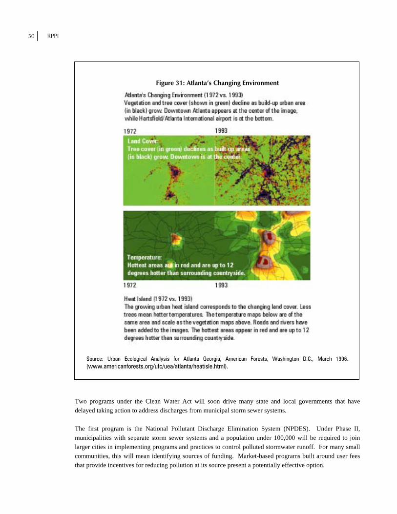
50 RPPI
Figure 31: Atlanta’s Changing Environment
Source: Urban Ecological Analysis for Atlanta Georgia, American Forests, Washington D.C., March 1996. (www.americanforests.org/ufc/uea/atlanta/heatisle.html).
Two programs under the Clean Water Act will soon drive many state and local governments that have delayed taking action to address discharges from municipal storm sewer systems. The first program is the National Pollutant Discharge Elimination System (NPDES). Under Phase II, municipalities with separate storm sewer systems and a population under 100,000 will be required to join larger cities in implementing programs and practices to control polluted stormwater runoff. For many small communities, this will mean identifying sources of funding. Market-based programs built around user fees that provide incentives for reducing pollution at its source present a potentially effective option.
PREPARING FOR THE STORM 51
The second program will attempt to better assess the health of watersheds beginning at the scale of river basins and to develop detailed plans and set timetables to reduce pollutant loads so that unhealthy water bodies can recover. Lawsuits filed in at least 30 states pushing the EPA to enforce provisions of the Clean Water Act have turned attention to the Total Maximum Daily Load (TMDL) program, which essentially requires that unhealthy water bodies be identified and cleaned up. In 16 states, EPA is under court order to establish schedules for clean up if the states do not do so themselves.69 In August 1999, the EPA announced a proposed rule requiring for the first time that all states take a watershed approach to identify impaired waters and submit a schedule for cleaning them up.70 Many adverse watershed impacts come from urban stormwater and agricultural runoff rather than industrial discharges. However one views the merits of the EPA rules and the TMDL requirements, they are creating a context in which local governments have heightened their attention to stormwater and watershed management concerns.
B. Effluent Trading and Stormwater Utilities Within this context, some localities have begun to introduce effluent trading. This approach is similar to emissions-trading programs for air pollution. The first such program applied to water pollution within a river was initiated in 1989 in the Tar-Pamlico River Basin in North Carolina.71 Now the adjoining Neuse River Basin is also adopting effluent trading. Both rivers feed into the Pamlico Sound Estuary. Studies show that nutrient-enriched runoff from farms and cities is causing algal blooms and fish kills. Recently, nutrient enrichment was implicated in outbreaks of toxin-producing microorganisms known as Pfisteria. In 1997, an agreement was reached to reduce nitrogen loading from the rivers entering Pamlico Sound by 30 percent within five years. Effluent trading provides a more economically efficient way to reach a pollution-reduction goal than the use of one-size-fits-all regulation. For example, a leading source of nitrogen is sewage effluent. Since treatment plants vary in their removal efficiency, the most efficient plant in the Neuse Basin can remove nitrogen at a cost of $0.14 per pound, while removal at the least efficient plant costs $27.00 per pound.72 Under the effluent-trading scheme, the community with the least efficient plant can pay those communities able to increase their level of nitrogen removal beyond the required level. The result is pollution reductions at far less cost than through increased treatment at their existing plants. Effluent trading may also result in a much faster reduction in pollution through existing plants than would result if communities with inefficient plants have to build new ones. If goals are not met through effluent trading, the partners in the Tar-Pamlico trading agreement have agreed to abide by a uniform regulation. As point sources of pollution are reduced, effluent trading could be a boon to stormwater utilities that can reduce nonpoint pollution at relatively low cost. The prospect of effluent trading may reinforce incentives of stormwater utilities (public or private) to work with landowners to develop and maintain properties in ways that minimize pollution and watershed damage.
69 U.S. Environmental Protection Agency, Total Maximum Daily Load Program, www.epa.gov/OWOW/tmdl/index.html. 70 “EPA Rule Puts More Burden on States to Clean Waterways,” The Atlanta Journal-Constitution, August 15,1999, p. B2 71 David W. Riggs, Market Incentives for Water Quality: A Case Study of the Tar-Pamlico River Basin, North Carolina
(Clemson, South Carolina: Center for Policy Studies, Property Rights Project December, 1993). 72 David Moreau, Chair Department of City and Regional Planning, UNC at Chapel Hill, Presentation at Sustainable
Development Conference (Atlanta, Georgia: Civic Center, August 20, 1999).

52 RPPI
Unless development patterns change, urban stormwater runoff problems will persist and likely increase. One reason suburban development with large road networks and paved spaces has been so dominant is that, until recently, watershed management costs were not incorporated into the cost of building urban/suburban communities. As communities continue to grow, those that adopt user-fee funded stormwater utilities will be able to fund necessary infrastructure and encourage low-impact development. An estimated 350 municipalities around the nation now have some form of fee-based utility. Most of these utilities have been formed in the last decade.73 The trend toward ecosystem-based watershed management combined with implementation of market-based funding mechanisms offers high potential to reduce pollution, improve the health of water systems, and generate development patterns that work with natural hydrological cycles and natural vegetation and topography. The end result will be an improved environment, market-based land development, and dynamic local economies.
73 Brant Keller, Director, city of Griffin Stormwater Department, city of Griffin, Georgia, interview with author, August 9, 1999.
PREPARING FOR THE STORM 53
About the Author
arrett Walker’s interest in ecology and environmental protection led him to leave the world of small business in the early 1990s to pursue a Masters degree in ecology and sustainable development from the University of Georgia Institute of Ecology. Barrett’s Masters thesis examined community-based urban watershed protection, focusing on Atlanta, Georgia as a case study. Subsequent to his
graduation, Barrett chaired the Metropolitan Atlanta Watershed Initiative in 1998. Barrett writes and speaks extensively about surface and ground water protection, and serves as a trustee of the Alex Walker Foundation, which promotes free-market approaches to address economic imbalances.
Other Relevant RPPI Policy Studies
Alexander Volokh, Lynn Scarlett, and Scott Bush, Race to the Top: The Innovative Face of State Environmental Management, Policy Study No. 239 (Los Angeles: Reason Public Policy Institute, February 1998). Christopher A. Hartwell, Simplify, Simplify: Alternative Permitting at the State Level, Policy Study No. 253 (Reason Public Policy Institute, February 1999). Michael Harrington and Christopher A. Hartwell, Rivers Among Us: Local Watershed Preservation and Resource Management in the Western United States, Policy Study No. 259 (Reason Public Policy Institute, June 1999).
B