present victor w. henderson jack r. stevens marty v ... · pdf filethe call of the roll...
TRANSCRIPT

MINUTES OF A MEETING OF THE BOARD OF DIRECTORS OFTARRANT REGIONAL WATER DISTRICT
HELD ON THE 21st DAY OF JULY 2015 AT 9:30 A.M.
The call of the roll disclosed the presence of the Directors as follows:
PresentVictor W. Henderson
Jack R. StevensMarty V. Leonard
Jim LaneMary Kelleher
Also present were Jim Oliver, Alan Thomas, Dan Buhman, Darrel Andrews,
Darrell Beason, Steve Christian, Linda Christie, Wesley Cleveland, Randall Cocke, J. D.
Granger, Tina Hendon, Rachel Ickert, Nancy King, David Marshall, Sandy Newby,
Wayne Owen, Kirk Thomas and Louie Verreault.
Also in attendance were George Christie, General Counsel for Tarrant Regional
Water District (Water District); Ethel Steele, Hal Ray, Mike Atchley, and Jeremy Harmon
of Pope, Hardwicke, Christie, Schell, Kelly & Ray LLP; Dudley Brown of Save Eagle
Mountain Lake; Don McDaniel of TMG Imaging; Bill Mullican and Doug Varner of CDM
Smith; Dick Fish of Lake Country POA; Denis QuaIls from the City of Dallas Water
Utilities; Bill Paxton of Trinity River Communications — JV; David Medanich of First
Southwest; Stefan Schuster of MWH; Greg Welch of CH2M Hill; Christine Jacoby of JQ
Infrastructure; Andra Beatty; Coy Veach of Freese and Nichols; Bill Pembroke of
Parsons; and Van Kelley of Intera.
President Henderson convened the meeting with the assurance from
management that all requirements of the ‘open meetings” laws had been met.

1.
All present were given the opportunity to join in reciting the Pledge of Allegiance.
2.
On a motion made by Director Stevens and seconded by Director Leonard, the
Directors voted unanimously to approve the minutes from the meeting held on June 16,
2015. It was accordingly ordered that these minutes be placed in the permanent files of
the Tarrant Regional Water District.
3.
With the recommendation of management, Director Henderson moved to
approve the acceptance of a contribution in the amount of $35,000 from Andrews
Distributing for sponsorship of Fort Worth’s Fourth. Director Lane seconded the motion
and the vote in favor was unanimous.
4.
With the recommendation of management, Director Leonard moved to approve a
contract with CDM Smith in the amount of $348,245 for a Business Case Evaluation of
Aquifer Storage and Recovery (ASR). Funding for this contract is included in the Bond
Fund. Director Kelleher seconded the motion and the vote in favor was unanimous.
5.
With the recommendation of management, Director Leonard moved to approve
the Contractor’s Resolution on Authorized Representative as requested by the Texas
Water Development Board as part of their process for SWIFT funding. This assurance
declares that Sandy Newby and Ed Weaver with be the District’s authorized
representatives to act on behalf of Tarrant Regional Water District. Director Lane

seconded the motion and the vote in favor was unanimous.
6.
With the recommendation of management, Director Stevens moved to approve
the Contractor’s Act of Assurance as requested by the Texas Water Development
Board as part of their process for SWIFT funding. This assurance declares that the
District will construct the Integrated Pipeline Project, for which it will receive SWIFT
funding. Director Lane seconded the motion and the vote in favor was unanimous.
7.
With the recommendation of management, Director Kelleher moved to approve a
contract with Whitmore and Sons, Inc. in the amount of $74,494.32 to provide services
for construction of educational demonstration landscaping on the District’s Fort Worth
campus. Funding for this contract is included in the FY 2015 General Fund Budget.
Director Lane seconded the motion and the vote in favor was unanimous.
8.
With the recommendation of management, Director Lane moved to approve a
contract with TMI Coatings, Inc. in the amount of $323,800 for the refurbishing of the
Richland-Chambers spillway stop logs. Funding for this contract is included in the FY
2015 Revenue Fund Budget. Director Leonard seconded the motion and the vote in
favor was unanimous.
9.
With the recommendation of management, Director Stevens moved to approve a
contract with the University of Texas at Arlington in the not to exceed amount of
$1 ,051 ,676 for a seismic evaluation of Eagle Mountain Lake Dam. This is anticipated to

be a three-year study. Funding for this contract is included in the Bond Fund. Director
Kelleher seconded the motion and the vote in favor was unanimous.
10.
With the recommendation of management, Director Leonard moved to approve a
contract with CH2M Hill in the amount of $3,044,922 for Operational Information and
Operations Manuals for the Integrated Pipeline Project. Funding for this contract is
included in the Bond Fund. Director Stevens seconded the motion and the vote in favor
was unanimous.
11.
With the recommendation of management, Director Stevens moved to approve a
contract amendment with CDM Smith in the not to exceed amount of $944,251 to
produce final design and construction contract documents and Bid and Construction
Phase Services for the Pressure Reduction/Control Station that connects the Integrated
Pipeline into the Kennedale Balancing Reservoir. Funding for this amendment is
included in the Bond Fund. Director Lane seconded the motion and the vote in favor
was unanimous.
12.
With the recommendation of management, Director Lane moved to approve a
Change Order with Garney Construction Company in the not to exceed amount of
$646,888.66 to add construction improvements to CR NE 190 and electrical
improvements associated with the access road from CR NE 190 to the interconnect
facility. Payment for work under the Change Order will be based on unit pricing.
Funding for this Change Order is included in the Bond Fund. Director Kelleher

seconded the motion and the vote in favor was unanimous.
13.
With the recommendation of management, Director Lane moved to approve a
contract amendment with HDR Engineering, Inc. in the amount of $425,527 for Cathodic
Protection Systems engineering services for Bid Phase of Section 14 Pipeline and
Construction Phase of the S2x12 Interconnect, Section 14 Pipeline, and Section 15.2
Pipeline of the Integrated Pipeline Project. Funding for this amendment is included in
the Bond Fund. Director Leonard seconded the motion and the vote in favor was
unanimous.
14.
Staff Updates• Update on System Status• Update on Water Quality Sampling• National Water Quality Initiative Video
15.
There were no persons from the general public requesting the opportunity to
address the Board of Directors.
The Board of Directors recessed for a break from 11:30 a.m. to 11:40 a.m.
16.
The presiding officer next called an executive session at 11:40 a.m. under
V.T.C.A., Government Code, Section 551 .071 to consult with legal counsel on a matter
in which the duty of counsel under the Texas Disciplinary Rules of Professional Conduct
clearly conflicts with Chapter 551, Texas Government Code, and to conduct a private
consultation with attorneys regarding pending or contemplated litigation (Monty Bennett
v. Tarrant Regional Water District, Cause No. 153-264899-13, in the 1 53rd District Court
of Tarrant County, Texas, Cause No. 02-13-00354-CV, in the Second Court of Appeals,
Fort Worth, Texas and Cause No. 15-0030 in the Supreme Court of Texas; Tarrant
Regional Water District v. Lazy WDistrictNo. 1, eta!., Cause No. 2014C-0144 in the 3d
District Court of Henderson County, Texas, Cause No. 12-14-00329-CV in the Twelfth
Court of Appeals, Tyler, Texas and Cause No. 15-0117 in the Supreme Court of Texas;
White House Cemetery Association v. Jasper and Evelyn Stevens and Tarrant Regional
Water District, Cause No. 08001-CCL-15, in the County Court at Law No. I of
Henderson County, Texas); and under Section 551.072 to deliberate the purchase,
exchange, lease or value of real property. Upon completion of the executive session at
11:54 a.m., the President reopened the meeting.
17.
With the recommendation of management, Director Stevens moved to grant
authority to acquire permanent easement interests in, over, under, and across the
following described property for the public use and purpose of construction and
operation of the IPL Project by purchase or, if negotiations to acquire the property by
purchase are unsuccessful, by the use of the power of eminent domain. The motion
was made in the form provided by Chapter 2206, Texas Government Code, and
indicated that it intended to apply to all the units of real property described below.
Funding for this acquisition is included in the Bond Fund.
IPL Parcel 335 A permanent easement interest in, over and across a 16.016-(Reed) acre tract of land situated in the A. Ferguson Survey, Abstract
Number 350, and the W. Lockwood Survey, Abstract Number647, Ellis County, Texas, and being more particularlydescribed as a portion of that certain 338.582-acre tract ofland conveyed to Reed Land Management Ltd. by instrumentrecorded in Volume 2010, Page 1095, Official PublicRecords, Ellis County, Texas, such tract being further

described in the survey plat for Parcel 335 attached hereto.An appraisal prepared by an independent, qualified realestate appraiser using standard accepted valuationtechniques established the amount of $78,916 as justcompensation for the above-described property.
IPL Parcel 512 A permanent easement interest in, over and across a 6.317-(Blalock) acre tract of land situated in the Louis Powell Survey,
Abstract Number 663, Navarro County, Texas, and beingmore particularly described as a portion of that certain80.000-acre tract conveyed to Kerry Blalock by deedrecorded in Instrument Number 00002396, Official PublicRecords, Navarro County, Texas, such tract being furtherdescribed in the survey plat for Parcel 512 attached hereto.An appraisal prepared by an independent, qualified realestate appraiser using standard accepted valuationtechniques established the amount of $45,919 as justcompensation for the above-described property.
IPL Parcel 513 A permanent easement interest in, over and across a(Galliford) 12.348-acre tract of land situated in the Louis Powell Survey,
Abstract Number 663, Navarro County, Texas, and beingmore particularly described as a portion of that certain210.738-acre tract conveyed to William T. Galliford andSharron Hill Galliford by deed recorded in InstrumentNumber 00007647, Official Public Records, Navarro County,Texas, such tract being further described in the survey platlor Parcel 513 attached hereto. An appraisal prepared by anindependent, qualified real estate appraiser using standardaccepted valuation techniques established the amount of$98,571 as just compensation for the above-describedproperty.

Parcel 335Integrated Pipeline Project
Page 1 of5
EXHIBIT “A”Property Description
Being 16.016-acres (697,678 square feet) of land situated in the A. Ferguson Survey, AbstractNumber 350 and the W. Lockwood Survey, Abstract Number 647, Ellis County, Texas, andmore particularly that certain 338.582 acre tract of land conveyed to Reed Land ManagementLtd., by instrument recorded in Volume 2010, Page 1095, Official Public Records, Ellis County,Texas, (O.P.R.E.C.T.), and being further described as follows:
COMMENCING at 1/2 inch iron rod found for the northwest corner of said tract of landconveyed to Reed Land Management Ltd., said 1/2 inch iron rod being an interior corner in thesouth line of that certain tract of land conveyed to Lu Ann Aday, by instrument recorded inVolume 2513, Page 517, O.P.R.E.C.T., said 1/2 inch iron rod being an interior eli corner in thenorth line of said Abstract Number 647, said 1/2 inch iron rod also being the most southerlysouthwest corner of the J. Roberts Survey, Abstract Number 909;
THENCE South 13 degrees 10 minutes 24 seconds East, along the common line of said ReedLand Management Ltd. tract and said Aday tract, a distance of 179.81 feet to a 5/8 inch iron rodwith cap stamped “GORRONDONA” set for the POINT OF BEGINNING (N:6,813,966.774,E:2,461,335.004), said 5/8 inch iron rod with cap stamped “GORRONDONA” also being in OldMaypearl Road (+1- 17’ asphalt pavement) (no deed of record found);
(1) THENCE South 72 degrees 39 minutes 26 seconds East, a distance of 4727.87 feet to a 5/8 inchiron rod with cap stamped “GORRONDONA” set for corner;
(2) THENCE South 57 degrees 02 minutes 23 seconds East, a distance of 33.08 feet to a 5/8 inchiron rod with cap stamped “GORRONDONA” set for corner in the southerly line of said ReedLand Management Ltd. tract, said 5/8 inch iron rod with cap stamped “GORRONDONA” beingin the northerly line of that certain tract of land described as Tract IV conveyed to YanceyCunningham family, LP., by instrument recorded in Volume 2273, Page 941, O.P.R.E.C.T.;
(3) THENCE South 61 degrees 01 minutes 59 seconds West, along the common line of said ReedLand Management Ltd. tract and said Yancey-Cunningham Family, LP. tract, passing at adistance of 5.69 feet, a 1/2 inch iron rod found for reference, in all, a total distance of 195.13 feetto a 5/8 inch iron rod with cap stamped “GORRONDONA” set for corner, from which a 1/2 inchiron rod found for an angIe point in the southerly line of said Reed Land Management Ltd. tractbears South 61 degrees 01 minutes 59 seconds West, a distance of 860.06 feet, said 1/2 inch ironrod being an angle point in the northerly line of said Yancey-Cunningham Family, LP. tract;
(4) THENCE North 72 degrees 39 minutes 26 seconds West, a distance of 4536.53 feet to a 5/8inch iron rod with cap stamped “GORRONDONA” set for corner in the westerly line of saidReed Land Management Ltd. tract, said 5/8 inch iron rod with cap stamped “GORRONDONA”being in the southerly line of said Aday tract, said 5/8 inch iron rod with cap stamped“GORRONDONA” also being in said Old Maypearl Road;
EXHIBIT A-i

Parcel 335Integrated Pipeline Project
Page 2 of 5
(5) THENCE North 13 degrees 10 minutes 24 seconds West, along the common line of said ReedLand Management Ltd. tract and said Aday tract, and with said Old Maypearl Road, a distanceof 174.12 feet to the POINT OF BEGINNiNG and containing 16.016-acres (697,678 squarefeet) of land, more or less.
NOTE: Basis of bearing is the Texas State Plane Coordinate System, North Central Zone (4202) NorthAmerican Datum (NAD83)(2007) with all distances adjusted to surface by project combined scalefactor 0.999946003 0.
NOTE: Plat to accompany this legal description.
I do certif’ on this 17th day of August, 2012, to Ellis County Abstract and Title Company, Stewart TitleGuaranty Company, Tarrant Regional Water District, that a survey was made on the ground as per the fieldnotes shown on this survey and is true and correct according to the standards of the Texas Society ofProfessional Surveyors Standards and Specifications for a Category 2, Condition IV Survey, and accurate as tothe boundaries and areas of the subject property and the size, location and type of buildings and improvements,if any, and shows the location of all visible easements and rights-of-way and the rights-of-way, easements andother matters of record as listed in Schedule B of the Commitment for Title issued by Stewart Title GuarantyCompany, with an effective date of August 8, 2012, issued date of August 20, 2012 GF # 1207088 affecting thesubject property and listed in Exhibit “A-i” attached hereto.
Except as shown on the survey: (i) there are no visible encroachments upon the subject property byvisible improvements on adjacent property, (ii) there are no visible encroachments on adjacent property,streets or alleys by any visible improvements on the subject property, and (iii) there are no visibleconflicts or discrepancies.
This survey substantially complies with the current Texas Society of Professional Surveyors Standards andSpecifications for a Category 2, Condition IV Survey
R stered Profession Land SurveyorTexas Registration No. 5254
Dated:
_________

-
g.
‘-‘ NM. FOUND
\\
\NOTE: KNOWN UNDERGROUND UTILITIES SHOWN ARE
QUALITY LEVEL 9 AND D SUE (08/20/2012)NOTE: LEGAL DESCRIPTION TO ACCOMPANY THIS PLAT
GORRONDONA &ASSOCIATES, INc.
7524 JACI< NEWELL BLVD SOUTHFORT WORTH, TEXAS 76118PHONE (817)496—1 424FAX (617)496—1768
PRO] NO:
EXHIBIT “A”PARCEL 335
J. ROBERTS SURVEYABSTRACT 909
PC PARCEL 333CU ANN AI3AY
VOLUME 2513, PAGE 517O.P.R.E.C.T.
\
LEGEND• = MARKER FOUND AS NOTED
o = 5/8” IRS WITH CAPSTAMPED “GORRONDONA”
= POWER POLE
-I-
\
1
13’10’24 E179.81’
REED LAND MANAGEMENT LTD.VOLUME 2010, PAGE 1095
O.P.R.E.C.T.CALLED 338.582 ACRES
\‘
—-- \N 13’1O’24” W’
174.12’ /SEE /
DETAIL
\
\\
DETAIL “A”NOT TO SCALE
PARCEL 33516.016 AC.
697,678 SQ. FT.
N
W. LOCKWOOD SURVEYABSTRACT 647
•
•
“I.
I.UU
(I)
UUU)
N
400
tJ
A. FERGUSON SURVEYABSTRACT 350
400 200 0
GRAPHIC SCALE IN FEETI” = 400
SCALE; 1” 400’DATE: 09—24—2012DRAWN BY: CACHECKED BY: JBREViSED DAlE: 0—16—2012
EXHIBIT “A’SEGMENT 14, PARCEL 335
REED LAND MANAGEMENT LTD.
INTEGRATED PIPELINE PROJECT
BASIS OF BEARING IS THE TEXAS STATE PLANE COORDINATESYSTEM, NORTH CENTRAL ZONE (4202) NORTH AMERICAN DATUM -. r —
(NAD83)(2007) WITH ALL DISTANCES ADJUSTED TO SURFACE BY “ ‘-‘ 3PRO.JECT COMBINED SCALE FACTOR 0.9999460030

EXHIBIT “A” LEGENDPARCEL 335
MARKER FOUND AS NOTED
o = 5/8” IRS WITH CAPSTAMPED “GORRONDONA”
= POWER POLE
-77’
\\
REED LAND MANAGEMENT LTD.VOLUME 2010, PAGE 1095
O.P.R.E.C.T.CALLED 338.582 ACRES
W. LOCKWOOD SURVEYABSTRACT 647
\\
W. STEWARTABSTRACT
SURVEY956
7
FENcE LINE
/PARCEL 33516.016 AC.
,697,678 SQ. FT. —
\
\\
NICK HESTER AND KAYLA 0. HESTERVOLUME 2083, PAGE 2251
O.P.R.E.C.T.
I& —I —
—I
‘H
9
WATER VALVE E LINE
IRL PARCEL 338ALVA C. CALVERT. JR.
AND SUZANNE I. CALVERTVOLUME 2161. PAGE 1739
OP. R.E.C.T.
DETAIL “B”NOT TO SCALE
A. FERGUSON SURVEYABSTRACT 350
BUENA SISTA-BETHEL SPECIAl.U1JTY DISTRICTWATER LINE
LEVEL 0 SUE
S 5T02’23” E33.08’
-7
-7
1/2’ IRV.
7
w195.13’
7
PC PARCEL 339REMAINDER OFSECOND TRACT
JAMES HARRY HITT, TRUSTEE OFTHE FANNIE HITT ESTATE TRUST
VOLUME 2413, PACE 1609O.P.R.E.C.T.
IPL PARCEL 337TRACT IV
YANCEY—CUNNINGHAU FAMILY, CR.VOLUME 2273, PAGE 941
O.P.R.E.C.T.
S 61’O1’59”195.1 3\
NOTE: KNOWN UNDERGROUND UTILITIES SHOWN AREQUALITY LEVEL B AND D SUE (08/20/2012)
NOTE: LEGAL DESCRIPTION TO ACCOMPANY THIS PLAT
N
400
CORRONDONA &ASSOGIATES, INC.
7524 .ACK NEWELL BLVD. SOUTHFORT WORTH, TEXAS 16118PHONE (81 7)496—1424FAX (817)496—1768
200
SHEET TITLE
PRO] NO:
GRAPHIC SCALE IN1” = 400’
FEET
SCALE: 1 400DAlE: 09—24—2012DRAWN BY: CACHECKED BY: lBREVISED DATE: 10—15—2012
EXHIBIT “A”SEGMENT 4, PARCEL 335
REED LAND MANAGEMENT LTD.
PROJECTINTEGRATED PIPELINE PROJECT
BASIS OF BEARING IS THE TEXAS STATE PLANE COORDINATESYSTEM. NORTH CENTRAL ZONE (4202) NORTH AMERICAN DATUM(NAD83)(2007) WITH ALL DISTANCES ADJUSTED TO SURFACE BYPROJECT COMBINED SCALE FACTOR 0.9999460030

Parcel 512Integrated Pipeline Project
Page 1 of5
EXHIBIT “A”Property Description
Being 6.3 17 acres (275,181 square feet) of land situated in the Louis Powell Survey, AbstractNumber 663, Navarro County, Texas and more particularly that certain 80.000 acre tractconveyed to Kerry Blalock by deed recorded in Instrument Number 00002396, Official PublicRecords, Navarro County, Texas (O.P.R.N.C.T.), and being further described as follows:
COMMENCING at the most Southerly corner of said Blalock tract, being in the Northwesterlyline of that certain tract of land conveyed to Randall 3. Bancroft and wife, Karen A. Bancroft bydeed recorded in Volume 1452, Page 771, Deed Records, Navarro County, Texas (D.R.N.C.T.),and Volume 1575, Page 741, D.R.N.C.T., being in County Road NE 3130, variable width right-of-way (No Deed of Record Found) from which a found 3.’8 inch iron rod bears N 31%5’28” W,a distance of 3 1.28 feet;
THENCE N 32°07’38” W, departing said County Road NE 3130 and along the Southwesterlytine of said Btalock tract, a distance of 1,957.51 feet to the most Westerly corner of said Blalocktract, being in the Southeasterly line of that certain tract of land conveyed to Wittiam Alan Payneand spouse, Vicki Lee Payne by deed recorded in Volume 1493, Page 222, D.R.N.C.T., andbeing in the Northwesterly line of said Louis Powell Survey and the Southeasterly line of theR.H. Matthews Survey, Abstract Number 586;
THENCE N 57°28’26” E, along the Northwesterly line of said Blalock tract and said LouisPowell Survey and the Southeasterly line of said Payne tract and said R.H. Matthews Survey, adistance of 567.81 feet to a set 5/8 inch iron rod with TranSystems cap for the most Westerlycorner and POINT OF BEGINNING of the tract herein described (N: 6,764,606.699,E: 2,657,232.879 Grid);
(1) THENCE N 572$’26” E, continuing along the Northwesterly line of said Blalock tract and saidLouis Powell Survey and the Southeasterly tine of said Payne tract and said R.H. MatthewsSurvey, and along the Westerly line of the tract herein described, a distance of 272.65 feet to aset 5/8 inch iron rod with TranSystems cap for the Northwesterly corner of the tract hereindescribed;
(2) THENCE N 8605’0l” E, departing the Northwesterly line of said Blalock tract and said LouisPowell Survey and the Southeasterly line of said Payne tract and said R.H. Matthews Survey andatong the Northerly line of the tract herein described, a distance of 198.29 feet to a set 5/8 inchiron rod with TranSystems cap for an angle point;
(3) THENCE S 79°50’18” E, continuing along the Northerly line of the tract herein described, adistance of6l8.55 feet to a set 5/8 inch iron rod with TranSystems cap for an angle point;
(4) THENCE S 70°35’ II” E, continuing along the Northerly line of the tract herein described, adistance of 315.06 feet to a set 5/8 inch iron rod with TranSystems cap for an angle point;
EXHIBIT A-2

Parcel 512Integrated Pipeline Project
Page 2 of 5
(5) THENCE $ 6259’ I 8” E, continuing along the Northerly line of the tract herein described, adistance of 372.31 feet to a set 5/8 inch iron rod with TranSystems cap for the point ofintersection with the Northeasterly line of said Blalock tract and the Southwesterly line of thatcertain tract of land conveyed to William T. Gatliford and wife, Sharron Hill Galliford by deedrecorded in Instrument Number 00007647, Official Public Records, Navarro County, Texas(O.P.R.N.C.T.), and being the Northeasterly corner of the tract herein described;
(6) THENCE S 3ldl9?0l E, along the Northeasterly tine of said Blalock tract and theSouthwesterly line of said Galliford tract and along the Easterly line of the tract herein described,a distance of 228.93 feet to a set 5/8 inch iron rod with TranSystems cap for the Southeasterlycorner of the tract herein described;
(7) THENCE N 85°02’ 14” W, departing the Northeasterly tine of said Btalock tract and theSouthwesterly line of said Galliford tract along the Southerly line of the tract herein described, adistance of 62.20 feet to a set 5/8 inch iron rod with TranSystems cap for an angle point;
(8) THENCE N $3°09’Sl” W, continuing along the Southerly line of the tract herein described, adistance of 62.20 feet to a set 5/8 inch iron rod with TranSystems cap for an angle point;
(9) THENCE N 62°59’ 18” W, continuing along the Southerly line of the tract herein described, adistance of 440.15 feet to a set 5/8 inch iron rod with TranSystems cap for an angle point;
(10) THENCE N 70°35’ll W, continuing along the Southerly line of the tract herein described, adistance of 290.76 feet to a set 5/8 inch iron rod with TranSystems cap for an angle point;
(11) THENCE N 79°50’ 18 W, continuing along the Southerly line of the tract herein described, adistance of 591.47 feet to a set 5/8 inch iron rod with TranSystems cap for an angle point;
(12) THENCE N 89°20’52” W, continuing along the Southerly line of the tract herein described, adistance of4l2.14 feet to the POINT OF BEGINNING, containing 6.317 acres (275,181 squarefeet) of land, more or less.

Parcel 512Integrated Pipeline Project
Page 3 of 5
NOTE: Basis of bearing is the Texas State Plane Coordinate System, North Central Zone (4202),North American Datum 1983 (NAD $3)(2007) with all distances adjusted to surface by projectcombined scale factor of 0.9999460030.
NOTE: Plat to accompany this legal description.
I do certify on this 19th day of February, 2015, to Corsicana Title & Abstract Company, LLC,Commonwealth Land Title Insurance Company and Tarrant Regional Water District, that asurvey was made on the ground as per the field notes shown on this survey and is true andcorrect according to the standards of the Texas Society of Professional Surveyors Standards andSpecifications for a Category 2, Condition IV Survey, and accurate as to the boundaries andareas of the subject property and the size, location and type of buildings and improvements, ifany, and shows the location of all visible easements and rights-of-way and the rights-of-way,easements and other matters of record as listed in Schedule B of the Commitment for Title issuedby Commonwealth Land Title Insurance Company, ‘with an effective date of January 15, 2015,issued date of January 26, 2015, GF # CTI2-1 138-C affecting the subject property and listed inExhibit “A-I” attached hereto.
Except as shown on the survey: (1) there are no visible encroachments upon the subject propertyby visible improvements on adjacent property, (ii) there are no visible encroachments onadjacent property, streets or alleys by any visible improvements on the subject property, and (iii)there are no visible conflicts or discrepancies.
This survey substantially complies with the current Texas Society of Professional SurveyorsStandards and Specifications for a Category 2, Condition IV Survey.
Richard R. DorrRegistered Professional Land SurveyorTexas Registration Number 4780
Dated: 02/i9It

R. H. MATTHEWSSURVEY
ABSTRACT 586
(PC PARCEL 5(0WILLIAU ALAN PAYNE AND SPOUSE.
VICKI LEE PAYNEVOl.. 1493. PG. 222
D.R.N.C.T
EXHIBIT “A”PARCEL 512
0 = SET 5/8w IRON ROD WITH CAPSTAMPED TRANSYSTEMS’ (U.O.N.)
.irn>500 WEST SEVENTH STREETSUITE 1100FORT WORTH, TX 76102(617) 339’8950 (TEL)(817) 336•2247 (FAX)
\
\
//
KERRY BLALOCKINST. #00002396
0. P. R. N.C.T.CALLED 80.000 ACRES
PARCEL6.317
275,161
512AC.
SO. FT.
-.‘
_•.4
P.O.C.3/8 (PF EARS —N31’15’28 31_
LOUIS POWELLSURVEY
ABSTRACT 663(PC PARCEL 920
RANDAl.C 6. BANCROFT AND WIFE,KAREN k BANCROFTVOL 1452. PG. 771
D.R.NC.1.VOL 1575. PG. 741
D.R.N.C.T.
LEGEND
NOTES:KNOWN UNDERGROUND UTILITIES SHOWN ARE QUALITY LEVEL B SUE — (11—15—2012)(U.O.N.) INDICATES UNLESS OTHERWISE NOTED
N
• = MARKER FOUND AS NOTED 300
NOTE: LEGAL DESCRIPTION TO ACCOMPANY THIS PLAT.
150
PRINTED ON:
2/19/2015937:34
0
SHEET TITLE
300
GRAPHIC SCALE Hi FEET1” 300
EXHIBIT “A”SEGMENT 17, PARCEL
KERRY BLALOCK512

Parcel 513Integrated Pipeline Project
Page 1 of7
EXHIBIT “A”Property Description
Being 12.345 acres (537,895 square feet) of land situated in the Louis Powell Survey, AbstractNumber 663, Navarro County, Texas and more particularly that certain 210.738 acre tractconveyed to William T. Galliford and wife, Sharron Hill Galliford, by deed recorded inInstrument Number 00007647, Official Public Records, Navarro County, Texas (O.P.R.N.C.T.),and being further described as follows:
COMMENCING at a 1/2 inch iron rod found for the most southerly Southeasterly corner ofsaid 2 10.738 acre tract, being in the Southwesterly line of that certain tract of land conveyed toRoy Lynn Jenkins, Jr. by deed recorded in Instrument Number 00001584, O.P.R.N.C.T. andbeing in the Southeasterly line of said Louis Powell Survey and the Northwesterly line of theSamuel A. Ross Survey, Abstract Number 710;
THENCE N 33°10’39” W, along the Southerly line of said Galliford tract and the Southwesterlyline of said Jenkins tract, a distance of 278.72 feet to a set 518 inch iron rod with TranSystemscap set for the Southeasterly corner and POINT OF BEGINNING of the tract herein described(N: 6,763,416.531, Es 2,662,012.913 Grid);
(1) THENCE N 84°59’22” W, departing the Southerly line of said Galliford tract and theSouthwesterly line of said Jenkins tract and along the Southerly line of the tract herein described,a distance of 455.23 feet to a set 5/8 inch iron rod with TranSystems cap for an angle point;
(2) THENCE N 79°58’39” W, continuing along the Southerly line of the tract herein described, adistance of480.33 feet to a set 5/8 inch iron rod with TranSystems cap for an angle point;
(3) THENCE N 65°41 ‘05” W, continuing along the Southerly line of the tract herein described, adistance of 954.21 feet to a set 518 inch iron rod with TranSystems cap for an angle point;
(4) THENCE N 51 °23 ‘27” W, continuing along the Southerly line of the tract herein described, adistance of 447.37 feet to a set 5/8 inch iron rod with TranSystems cap for an angle point;
(5) THENCE S $5°21 ‘38” W, continuing along the Southerly line of the tract herein described, adistance of 463.75 feet to a set 5/8 inch iron rod with TranSystems cap for an angle point;
(6) THENCE N 87°56’27” W, continuing along the Southerly line of the tract herein described, adistance of 388.28 feet to a set 5/8 inch iron rod with TranSystems cap for the point ofintersection with the Southwesterly line of said Galliford tract and the Northeasterly line of thatcertain tract of land conveyed to Kerry Blalock by deed recorded in Instrument Number00002396, O.P.R.N.C.T., also being the Southwesterty corner of the tract herein described;
(7) THENCE N 31°19’Ol” W, along the Southwesterly line of said Galliford tract and theNortheasterly line of said Blalock tract and the Westerly line of the tract herein described, adistance of 228.93 feet to a set 5/8 inch iron rod with TranSystems cap for the Northwesterlycorner of the tract herein described;
EXHIBIT A-3
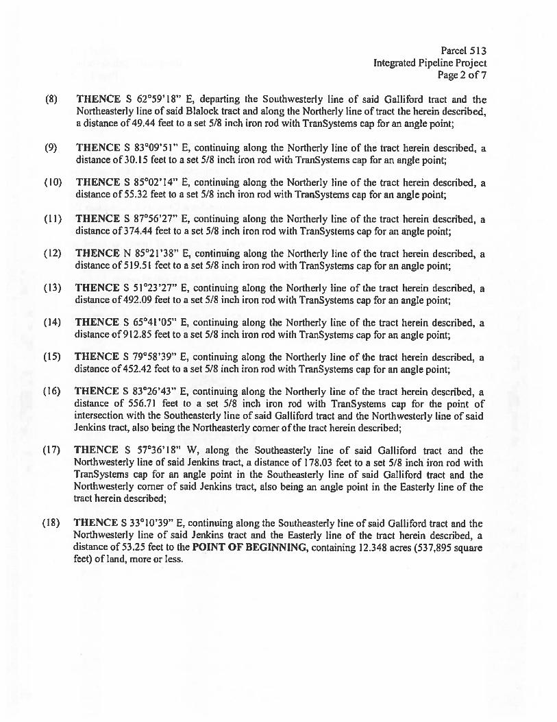
Parcel 513Integrated Pipeline Project
Page 2 of 7
(8) THENCE S 62°59’18” E, departing the Southwesterly line of said Galliford tract and theNortheasterly line of said Blalock tract and along the Northerly line of tract the herein described,a distance of 49.44 feet to a set 5/8 inch iron rod with TranSystems cap for an angle point;
(9) THENCE S 83°09’51” E, continuing along the Northerly line of the tract herein described, adistance of 30.15 feet to a set 5/8 inch iron rod with TranSystems cap for an angle point;
(10) THENCE S 85°02’14” E, continuing along the Northerly line of the tract herein described, adistance of 55.32 feet to a set 5/8 inch iron rod with TranSystems cap for an angle point;
(11) THENCE S 87°56’27” E, continuing along the Northerly line of the tract herein described, adistance of 374.44 feet to a set 5/8 inch iron rod with TranSystems cap for an angle point;
(12) THENCE N $5°2l’38” E, continuing along the Northerly line of the tract herein described, adistance of 519.51 feet to a set 5/8 inch iron rod with TranSystems cap for an angle point;
(13) THENCE S 51°23’27” E, continuing atong the Northerly line of the tract herein described, adistance of 492.09 feet to a set 5/8 inch iron rod with TranSystems cap for an angle point;
(14) THENCE S 65°41’05” E, continuing along the Northerly tine of the tract herein described, adistance of 912.85 feet to a set 5/8 inch iron rod with TranSystems cap for an angle point;
(15) THENCE S 79°58’39” E, continuing along the Northerly line of the tract herein described, adistance of 452.42 feet to a set 5.18 inch iron rod with TranSystems cap for an angle point;
(16) THENCE S 83°26’43” E, continuing along the Northerly line of the tract herein described, adistance of 556.71 feet to a set 5/8 inch iron rod with TranSystems cap for the point ofintersection with the Southeasterly line of said Gatliford tract and the Northwesterly line of saidJenkins tract, also being the Northeasterly comet of the tract herein described;
(17) THENCE S 5736’l8” W, along the Southeasterty line of said Galliford tract and theNorthwesterly line of said Jenkins tract, a distance of 178.03 feet to a set 5/8 inch iron rod withTranSystems cap for an angle point in the Southeasterly line of said Galliford tract and theNorthwesterly corner of said Jenkins tract, also being an angle point in the Easterly line of thetract herein described;
(18) THENCE S 33°10’39” E, continuing along the Southeasterly line of said Galliford tract and theNorthwesterly line of said Jenkins tract and the Easterly line of the tract herein described, adistance of 53.25 feet to the POINT OF BEGINNING, containing 12.348 acres (537,895 squarefeet) of land, mote or less.
Parcel 5t3tntegrated Pipeline Project
Page3 of7
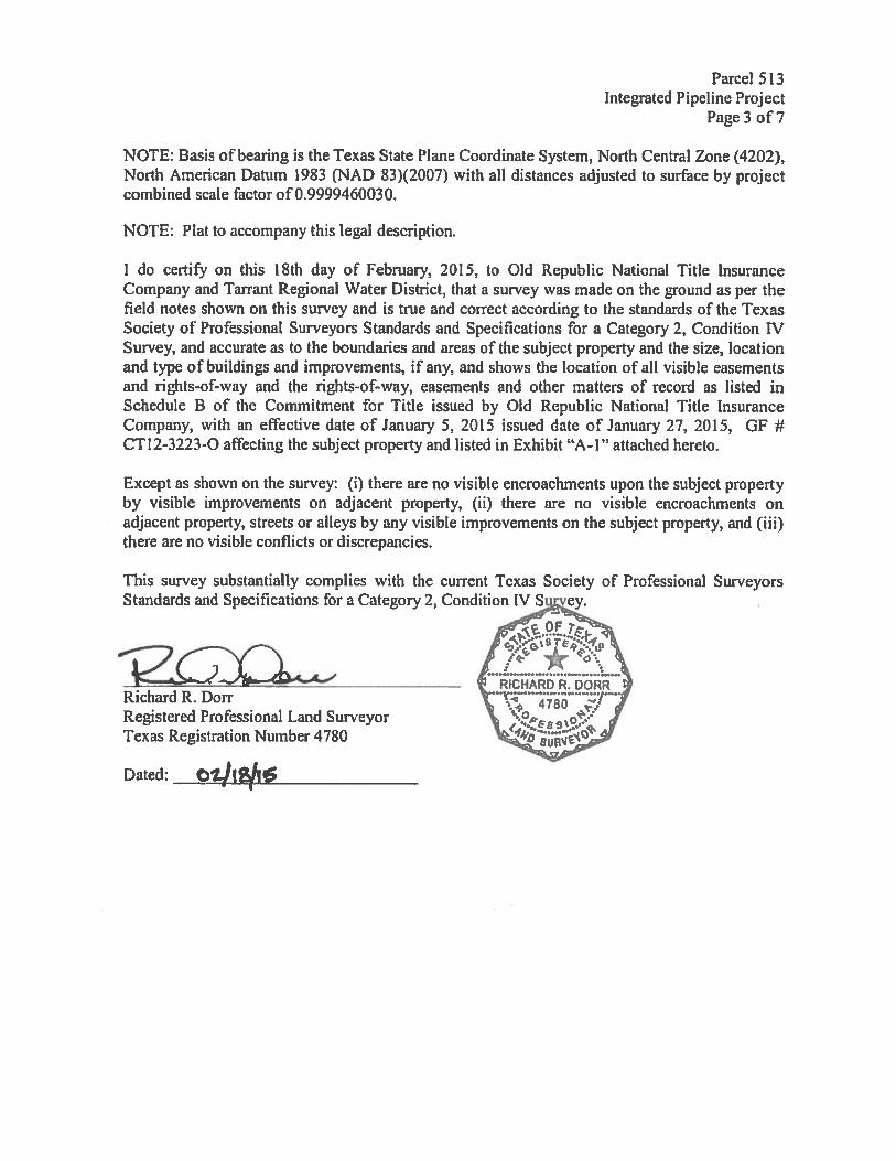
NOTE: Basis of bearing is the Texas State Plane Coordinate System, North Central Zone (4202),North American Datum 1983 (NAD $3)(2007) with all distances adjusted to surface by projectcombined scale factor of 0.9999460030.
NOTE: PIat to accompany this legal description.
I do certify on this 18th day of February, 2015, to Old Republic National Title InsuranceCompany and Tarrant Regional Water District, that a survey was made on the ground as per thefield notes shown on this survey and is true and correct according to the standards of the TexasSociety of Professional Surveyors Standards and Specifications for a Category 2, Condition IVSurvey, and accurate as to the boundaries and areas of the subject property and the size, locationand type of buildings and improvements, if any, and shows the location of all visible easementsand rights-of-way and the rights-of-way, easements and other matters of record as listed inSchedule B of the Commitment for Title issued by Old Republic National Title InsuranceCompany, with an effective date of January 5, 2015 issued date of January 27, 2015, Gf #CTI2-3223-O affecting the subject property and listed in Exhibit “A-I” attached hereto.
Except as shown on the survey: (i) there are no visible encroachments upon the subject propertyby visible improvements on adjacent property, (ii) there are no visible encroachments onadjacent property, streets or alleys by any visible improvements on the subject property, and (iii)there are no visible conflicts or discrepancies.
This survey substantially complies with the current Texas Society of Professional SurveyorsStandards and Specifications for a Category 2, Condition IV Survey.
Richard R. DorrRegistered Professional Land SurveyorTexas Registration Number 4780
Dated:
______________

LEGEND• = MARKER FOUND AS NOTED
O = SET 5/8” IRON ROD WITH CAPSTAMPED TRANSYSTEMS” C u.O.N.)
= POWER POLE
EXHIBIT “A”PARCEL 513
LOUIS POWELL SURVEYABSTRACT 663
LINE TABLE
\
BEARING DISTANCE[T 5625918”E 49.44’L2 583”09’51”E 30.15’C3 585’02’14”EL4 S5736’18W 178.03’C S33’1O39”E 5125’
\
\
WILLIAM T. GALLIFORD AND WIFE.SHARRON HILL GALLIFORD
INST. # 000076470. P.R. N.C.T.
CALLED 210.738 ACRES
‘ MIGUEL MATAABSTRACT
SURVEY601
\
‘L PARCEL 512KERRY 81.M.OCK
INST. 000002396O.P.R.N.C.T.
\S85’2 1 ‘38”W\ 463.75’
411/411456/512
S
S65’4 1 ‘O”E912.85
\
mucTu
—
0NCC (01.9)—
\
N411/236—’
PARCEL 513—12.348 AC.
537,895 SQ. FT.
—
IRON STAXE-4
5/8. IRF
7’411/234 / (P1 PARCEL 514
‘v N “ \ ROY LYNN JENKINS. JR./ ‘. —— ‘ INST. I 00001584
TEXAS POWER & LIGHT COMFANY—J N,.>’ O.P.R.N.C.T.
100’ WIDE EASEMENT —ç VOL 411, PG. 234 —
5/8 VOL. 411, PG. 236. 5/8” IRF VOL. 411, PG. 236 —
- VOL 411. PG. 41t —
— -VOL 456, PG. 512 7’
- 1/2” IRF 0.R.N.C.T. —
NOTES: s/8 IRF ,,
KNOWN UNDERGROUND UTILITIES SHOWNARE QUALIW LEVEL B SUE — 11—13—2012fu.0.N.) INDICATES UNLESS OTHERWISE NOTED - SAMUEL A. ROSS SURVEY
ABSTRACT 710
N
IranJ
600
PRINTED ON:2/16/20 IS8:37:31
NOTE: LEGAL DESCRIPTION T( ACCOMPANY THIS PLAT.
SHEET TITLE
300 0 600
500 WEST SEVENTH STRfETSLATE 1100FORT WORTh, TX 76102(817) 3396950 (TEL)(617) 335-2247 (FAX)
FIRM PEG. NO. 100383-00
GRAPHIC SCALE IN FEET1’ 600
EXHIBIT “A’SEGMENT 17, PARCEL 513
WILLIAM T. GALLIFORD AND WIFE,SHARRON HILL GALLIFORD
INTEGRATED PIPELINE PROJECT
In addition, R. Steve Christian and the staff of TRWD are authorized to initiate
eminent domain proceedings, to take all steps which may be reasonably necessary to
complete the acquisition of the above-described properties, to pay all customary,
reasonable and necessary closing and related costs, to deposit the amount of the
special commissioners’ award into the registry of the court in any eminent domain
proceeding, and to appeal any such award. Director Lane seconded the motion and the
vote in favor passed, with Directors Henderson, Leonard, Stevens, and Lane voting in
favor, and Director Kelleher voting against.
18.
With the recommendation of management, Director Leonard moved to grant
authority to acquire permanent easement interests, as set forth below, in, over, under,
and across the following described properties for the public use and purpose of
construction and operation of the Integrated Pipeline Project. Funding for these
acquisitions is included in the Bond Fund.
IPL Parcel 657 A permanent easement interest across a 5.000-acre tract of(Smith) land situated in the John Albright Survey, Abstract Number
16, Henderson County, Texas, and being part of thosecalled 23.5-acre, 13.5-acre, and 18-acre tracts of landdescribed by deed to Samuel C. and Mary Smith recordedby Volume 1787, Page 210, Deed Records, HendersonCounty, Texas, and further described by Last Will andTestament of Jack W. Smith, recorded in by Instrument No.174-2012, District Court Records Henderson County Texas,and being further described in the survey plat for Parcel 657attached hereto for the appraised value of $12,600.
IPL Parcel 665 A permanent easement interest across a 2.190-acre tract of(McElree) land situated in the John Albright Survey, Abstract Number
16, Henderson County, Texas, being part of that called10.379-acre tract described by deed to David M. and DebraMcElree recorded in Volume 1638, Page 137, DeedRecords, Henderson County, Texas, and being further

described in the survey plat for Parcel 665 attached heretofor the appraised value of $54,021.
IPL Parcel 683 A permanent easement interest across a 15.356-acre tract(Ryon Trust) of land situated in the Santos Sylvester Survey, Abstract
Number 694, Henderson County, Texas, and being moreparticularly described as a portion of that certain remainderof 60 acres conveyed to J.E. Ryon, Jr. or Elizabeth L. Ryon,Trustees for the J.E. & EL. Ryon Living Trust, dated June3, 1997, by deed recorded in Volume 1772, Page 93, DeedRecords of Henderson County, Texas, and a portion of thatcertain 160.05-acre tract conveyed to J.E. Ryon, Jr. orElizabeth L. Ryon, Trustees for the J.E. & E.L. Ryon LivingTrust, dated June 3, 1997, by deed recorded in Volume1772, Page 98, Deed Records of Henderson County,Texas, and being further described in the survey plat forParcel 683 attached hereto for the negotiated purchaseprice of $178,000.
IPL Parcel 698.1 & Permanent easement interests across a 6.047-acre tract of698.2 land (698.1) and a 10.053-acre tract of land (698.2), such(Alders) tracts being situated in the F. Brown Survey, Abstract
Number 81, in the W. Francher Survey, Abstract Number224, and in the S. Jones Survey, Abstract Number 961,Henderson County, Texas, said 6.047-acre tract beingmore particularly described as a portion of that certain 92.7-acre tract described as First Tract and that certain 160-acretract described as Third Tract, and the said 10.053-acretract being more particularly described as a portion of thatcertain 160-acre tract described as Third Tract and aportion of that certain 641.5-acre tract described asSeventh Tract as conveyed to Richard W. and JohnyceAlders, Trustees of the Richard and Johnyce Alders Trust,by instrument recorded in Volume 2311, Page 14,Henderson County Real Property Records, and asconveyed to Charles A. Alders or Jo Ann Alders, Trusteesfor the Alders Living Trust, dated July 30, 1990, byinstrument recorded in Volume 2142, Page 773, HendersonCounty Real Property Records, and being further describedin the survey plats for Parcels 698.1 and 698.2 attachedhereto for the negotiated purchase price of $237,500.
IPL Parcel 893 A permanent easement interest across a 1 .567-acre tract of(White) land out of the John Williams Survey, Abstract Number 877,
Navarro County, Texas, and being more particularlydescribed as a portion of that certain 10.13-acre tract of

land conveyed to Joe L. and Velma B. White by deedrecorded in Volume 1410, Page 803, Deed Records,Navarro County, Texas, and being further described in thesurvey plat for Parcel 893 attached hereto for thenegotiated purchase price of $28,750.
IPL Parcel 730 A permanent easement interest across a 6.828-acre tract of(Edwards) land situated in the Thomas Hanna Survey, Abstract
Number 304, Henderson County, Texas, and being moreparticularly described as a portion of that certain 121.5-acretract of land conveyed by instrument recorded in Volume1926, Page 628, Official Public Records, HendersonCounty, Texas, and being further described in the surveyplat for Parcel 730 attached hereto for the negotiatedpurchase price of $35,000.
IPL Parcel 731 A permanent easement interest across a 2.334-acre tract of(Montgomery) land situated in the Philip Jackson Survey, Abstract Number
392, Henderson County, Texas, and being more particularlydescribed as a portion of that certain 15.827-acre tractconveyed to Monte and Lisa Montgomery described as“Tract 2” in the instrument recorded in Volume 2278, Page600, Official Public Records, Henderson County, Texas,and being further described in the survey plat for Parcel 731attached hereto for the appraised value of $1 1,553.
IPL Parcel 1130 A permanent easement interest across a 9.442-acre tract of(Fitzhugh) land situated in the Philip Jackson Survey, Abstract Number
392, Henderson County, Texas, and being more particularlydescribed as a portion of that certain 77.019-acre tractconveyed to Larry H. and Karen K. Fitzhugh by instrumentrecorded in Volume 2100, Page 862, Official PublicRecords, Henderson County, Texas, and being furtherdescribed in the survey plat for Parcel 1130 attached heretofor the appraised value of $54,989.
IPL Parcel 719 A permanent easement interest across a 5.680-acre tract of(Gary) land situated in the J.H. Stirman Survey, Abstract Number
711, Henderson County, Texas, and being more particularlydescribed as a portion of that certain 76.5-acre tractconveyed to Jan Gary by instrument recorded in Volume1253, Page 480, Deed Records, Henderson, County,Texas, and being further described in the survey plat forParcel 719 attached hereto for the negotiated purchaseprice of $37,795.70.

IPL Parcel 721 A permanent easement interest across an 8.095-acre tract(Gary) of land situated in the Moses Cavitt Survey, Abstract
Number 149, Henderson County, Texas, and being moreparticularly described as a portion of that certain 187-acretract conveyed to Alton Gary by instrument recorded inVolume 874, Page 428, Deed Records, Henderson County,Texas, of which 1/2 interest was conveyed to Jan Gary byinstrument recorded in Volume 2283, Page 133, said DeedRecords and 1/2 interest was retained by the Alton GaryEstate, and being further described in the survey plat forParcel 721 attached hereto for the negotiated purchaseprice of $53,865.67.
IPL Parcel 1123 A permanent easement interest across a 7.146-acre tract of(Gary) land situated in the D.M. Morgan Survey, Abstract Number
557, Henderson County, Texas, and being more particularlydescribed as a portion of that certain 104.043-acre tract ofland conveyed to Ann Gary by instrument recorded inDocument Number 2014-00006770, Official PublicRecords, Henderson County, Texas, and being furtherdescribed in the survey plat for Parcel 1123 attached heretofor the negotiated purchase price of $47,550.90.
IPL Parcel 1131 A permanent easement interest across a 4.433-acre tract of(Gary) land situated in the D.M. Morgan Survey, Abstract Number
557, and the Lucy J. Vaughn Survey, Abstract Number 788,Henderson County, Texas, and being more particularlydescribed as a portion of that certain 50-acre tractconveyed to Alton and Ann Gary by instrument recorded inVolume 579, Page 35, Deed Records, Henderson County,Texas, of which 1/2 interest was conveyed to Jan Gary byinstrument recorded in Volume 2283, Page 133, said DeedRecords, and being further described in the survey plat forParcel 1131 attached hereto for the negotiated purchaseprice of $29,498.05.
IPL Parcel 1132 A permanent easement interest across a 10.620-acre tract(Gary) of land situated in the T.W. Frizzell Survey, Abstract
Number 237, and the D. Pilkington Survey, AbstractNumber 622, Henderson County, Texas, and being moreparticularly described as a portion of that certain 81 .5-acreFirst Tract and 7.5-acre Second Tract conveyed to Ann andAlton Gary by instrument recorded in Volume 1253, Page483, Deed Records, Henderson County, Texas, and beingfurther described in the survey plat for Parcel 1132 attachedhereto for the negotiated purchase price of $176,289.68.

Parcel 657Integrated Pipeline Project
Page 1 of6
Exhibit “A”Property Description
Being 5.000 acres (217,798 square feet) of land situated in the John Aibright Survey,Abstract Number 16, Henderson County, Texas and being part of that called 23.5-acre,that called 13.5-acre and that called 18-acre tracts of land described by Warranty Deedwith Vendor’s Lien to Samuel C. Smith and wife, Mary Smith (undivided interest),recorded by Volume 1787, Page 210, 1)ced Records, Henderson County, Texas(D.R.I1.C.T.) and further described by Last Will and Testament of Jack W. Smith,recorded by Instrument No. 174-20 12, I)istrict Court Records Henderson County Texas(D.C.R.H.C.T.), being a part of those parcels included by Quitelaim Deed with retainedLife Estate to Melanie Ann Boehm (Life hstate retained by Betty Jane Smith)(undivided interest) recorded by Document No. 201 2-00017253, D.R.H.C.T. and beingfurther described as follows:
COMMENCING, at a 8-inch wooden fence post found for the northwesterly corner ofthat called 50-acre tract of land described by Exhibit C — Third Tract, Tract 1, Volume1787, Page 210, D.R.H.C.T., the southwesterly corner of that called 190 acres describedby file Number 134-82 to Walter Louis Jackson, Sr. recorded by Volume 72, Page 47,(D.R.K.C.T.), and to W.W. Jackson, recorded by Volume 411, Page 106, D.R.H.C.T.;
THENCE, N 33°10’44” E, with the westerly line of said Jackson tract and the easterlyline of the 13.5 acre and 23.5 acre Smith tracts, a distance of 121.44 feet to a 1/2-inchiron rod with “PACHECO KOCI C’ cap set for the POINT OF BEGINNING
(N: 6,749,156.667, E: 2,742,040.189 Grid);
(1) THENCE, N 89°48’26” W, a distance of 1,448.91 feet to a 1/2-inch iron rod with“PACHECO KOCH” cap set on the westerly line of said 18 acre Smith tract and theeasterly line of that called Second I’ract described by Warranty Deed to Melvin B.Crouch and wife Barbara Crouch, recorded by Volume 423, Page 45, and Volume 697,Page 590, D.R.C1.C.T.;
(2) THENCE, N 3301044!! E with the line common to said Crouch tract and said Smithtract, a distance of 179.21 feet to a 1/2-inch iron rod with “PACHECO KOCH” cap set;
(3) THENCE, S 89°48’26” E, a distance of 1,448.91 feet to a 1/2-inch iron rod with“PACHECO KOCH” cap set on the aforesaid east line of the Jackson tract and the eastline of the Smith tract;

Parcel 657Integrated Pipeline Project
Page 2 of 6
(4) THENCE, S 33°lO’44” W with said common line, a distance of 179.21 feet to thePOINT OF BEGINNING and containing 5.000 acres (217,798 square feet) of land.
NOTE: Basis of bearing is the Texas State Plane Coordinate System, North CentralZone (4202), North American Datum 1983 (NAD 83)(2007) with all distancesadjusted to surface by project combined scale factor of 0.9999804020.
NOTE: Plat to accompany this legal description.
NOTE: All 1/2-inch iron rods set have a yellow cap stamped “PACHECO KOCH”
I do certify on this 30th day of May, 2014, to Fidelity National TitLe InsuranceCompany, Attorney’s Title Co Of I [enderson County and Tarrant Regional WaterDistrict, that a survey was made on the ground as per the field notes shown on thissurvey and is true and correct according to the standards of the Texas Society ofProfessional Surveyors Standards and Specifications for a Category 2, Condition IVSurvey, and accurate as to the boundaries and areas of the subject property and the size,location and type of buildings and improvements, if any, and shows the location of allvisible easements and rights-of-way and the rights-of-way, easements and other mattersof record as listed in Schedule B of the Commitment for Title issued by FidelityNational TitLe Insurance Company, with an effective date of January 3, 2014, issued dateof January 13, 2014 GF # 13-621-DD affecting the subject property and listed in Exhibit“A-i” attached hereto.
Except as shown on the survey: (i) there are no visible encroachments upon the subjectproperty by visible improvements on adjacent property, (ii) there are no visibleencroachments on adjacent property, streets or alleys by any visible improvements onthe subject property, and (iii) there are no visible conflicts or discrepancies.
.ies with the current Texas Society of Professionalions for a Category 2, Condition IV Survey.
TX Reg. Engineering Finn f-469TX Reg. Surveying Firm LS-100080-00
This surveySurveyors St
(
Dated:

N
LUC)
ft
LULUif)
-7.
-j
T
LEGI.ND
SURVEY EXHHBIT “A”16 RARCEL 657/ PARCEL 657
SAMUEL C. SMITH AND W!EE, MARY SMI1H(UNDIVIDED INTEREST)/ VOL. 1787, PC 210
D.R.H.C 1.LAST WILL & IESEAMENT OF JACK W. SMI’H
INST NO. 1/4—2012R.P.R.H.C .1.
MELANIE ANN BOEHM(LII-L L.SIAI[ RETAINED IBY BEFIY SIANE SMITH)(UNDIVIDED INTEREST)
DCC NO. 2O12—O0O 7253P P.R. H. C . f.
CAlLED 23—1/2 AC
?ARC[ %7AMU I C. S[aflhl I ANI)
WiLl., MARY SMIIH(I)NUIV)Ft) IN I [REST)VIL. 1 77, PG. 210
0.R.H.C ,T.LA ‘VII L & ‘I SIAMENT 7
OF IAC K VL MtONI NO. ‘ 74—2012
l.C .1.ME LANIE ANN B .‘ic I
(LIFE E5!A1[ REIAINtOBY H Fil/ JAN’MIi H)(oNCE/mED INIERES I)
DCC NO. 201% —00<) 1 725.5RP.R.HC ,T.
CA! I ED 13—1/2 AC
HINt S ON
‘1’’
JOHN ALB RIGHTABSTRACT
/
/50’ DELH CAS PIPELINEC ON’ORATJON EASEMENTVOL 655. PG6T2DRHCT
50
an
100
GRAPHIC SCALE IN FEET1” = 100
276 80’
59’a 66’
____________
N:6.:: A,5J;
PARCEL 6575.000 AC.
217798 SQ.FT.
/
7
14.24’
N ‘lO64’E1:1.44’
/
PC PARCI.L 658WALLR LOUI’ JAC KSOE, SR
FILE NO, I S4—82VOLUME 1%, 5AOC 41
OR I C I51W, JACKSON
FIRSI IRACTCIUt.’E ti’. PAGE 106
r.rc I
• iit.<[R FOUNt) AS NOR U
o = 1/2—INC H EI fO’)wf’ICIIiC0 KoiOt.A% SEI(UNiL 5’-. 011 I[ Wi
2
1 ‘,
,.-,
-
‘Sc)
s__I.‘q -
-1,,,,
I-lUFF K ‘) Ii’ UI D PGvOJND UTIUTIF ‘-1 Ufl6AR QIJL 1’ CV’ 6 UL — 2/08/201NOTE. LEGAL GESCRIPIION TO ACCOAiPANY THIS PIAT
N 0:0) /
Pacheco KochSS • FOTWOtS . HOUSTON
8350 N. CENTRAL EXPWY., SUITE 1000DALLAS. TEXAS 75206
PH. 972.2353031 FAX 9T2.23TX BEG. ENGINEERING FIRM F469TX REG. SURVEYING FIRM LS-100080
SHEET TITLE EXHIB IT “A”SEGMENT 19—2, PARCEL 657
SAMUEL C. SMITH AND WIFE, MARY SMITH,LAST WILL & TESTAMENT OF JACR W. SMITH
AND MELANIE ANN BOEHM (LIFE ESTATERETAINED BY BETTY JANE SMITH)
PROJECTINTEGRATED PIPELINE PROJECT
BASIS OF BEARING IS THE TEXAS STAlE PLANE COORDINATESYStEM, NORTH CENTRAL ZONE (4202) NORTH AMER[CAN DATUM(NAD83)( 2007) WITH ALL DISTANCES ADJUStED TO SURFACE BY -
PROJECT COMBINED SCALE FACTOR 0 9999804020

HO0
ft
HOHOu-I
HOz
I0
UCD<ft
UUU]
HOz-J
TUH
50 0 100
JOHN ALBRIGHT SURVEY EXHIBIT “A” ‘‘ NABSTRACT 16 PARCE. 657
PARCEL 657 PARCEL 657—<
SAMUEL C. SMITH AND SAMUEL C. SMITH AND
WIfE, MARY SMT WIFE, MARY SMITH
(UNDIVIDED INTEREST) (UNDIVIDED INTEREST) °‘o..
VOL. 1787, PG. 210 VOL. 1767, PC. 210
D.R.H.C.T. D.R.H.C.T.
LAST WILL & TESTAMENT CAST WILL & TESTAMENT
OF JACK W. SMITH OF JACK W. SMITH
INST NO. 1 74—2012 INST NO. 174—2012 100
R.P.R.H.C.T. R.P.R.H.C.T.
MELANIE ANN BOEHM MELANIE ANN BOEHM(uTE ESTATE RETAINED (_IFE ESTATE RETAINED
BY BEJY JANE SMITH) 9Y BETTY JANE SMITH)
(UNDIVIDED INTEREST) (UNDIVIDED INTEREST)
DOC NO 2012-00017253 DOC NO. 2012—00017253
R.P.R.H.C.1. R.P,R.H.C.T.
— CALLED 18 AC. S8948’26/
827.92’ — —
\ PARCEL 657
\ 5.000 AC. /\ 217,798 SOFT. 7
\ 877 92 7 ,?/— —
— N8948’%U”w1446.9,>/
—
66’
50° DELHI GAS PIPELINE / / /CORPORATION EASEMENTVOL 655. PC 632
DRHCT_%./
GRAPHIC SCALE IN FEET10
- 76.80’
/7//
//,/E CL N D / /20’ %C’.I 3RW.K COMPANY
• MARKER FOU’.D AS NOTEDVOL ,NO5. P’ I 30
o = 1/2—INCH IRON RODW/”PACHECO NOCH”CAP SET(UNLESS OTHERWISE N: CCI))
PARCEL 657SAMUEL C. SMITH AND
WIFE, MARY SMITH(UNDIVIDED NTERESI)VOL. 1787, PC. 210
D.R.H.C .1.LAST WILL & TESTAMENT
OF JACK W. SMITHINST NO. 1/4—2012
R.P.R.H.C 1.MELANIE ANN BOEHM
(LIFE ESTATL RETAINEDBY BETTY JANE SMITH)(UNDIVIDED NTER[ST)
DOC NO. 2012—00017253R. P.R. I1.C
CALLED 13—1/2 AC.
NOTE: KNOWN UNDERGROUND UTILITIES SHOWNARE QUALITY LEVEL 8 SUE — 2/08/2013NOTE: LEGAL I’TIfN 10 ACCOMPANY THIS PA1
RRISTLIJ ON.
Pacheco Koch• )WO,rH •
5350 N. CENTRAL EXPWY., SUITE 1000DALLAS, TEXAS 75206
PH. 972.235.3031 FAX 972.23595TX REG. ENGINEERING FIRM F469TX REG. SURVEYING FIRM CS-i 00050-00
SHEET TITLE EXH I B IT “A”SEGMENT 19—2, PARCEL 657
SAMUEL C. SMITH AND WIFE, MARY SMITH,LAST WILL & TESTAMENT OF JACK W. SMITH
AND MELANIE ANN BOEHM (LIFE ESTATERETAINED BY BETTY JANE SMITH)
PROJECTINTEGRATED PIPELINE PROJECT
BASIS OF BEARING IS THE TEXAS STATE PLANE COORDINATESYSTEM. NORTH CENTRAL ZONE (4202) NORTH AMERICAN DATUMfNAD83)(2.0O7) WITH ALL DISTANCES ADJUSTED TO SURFACE BYPROJECT COMBINED SCALE FACTOR 0.9999804020

/
IROM ROD WOUND
69461
H CFND• = MARKER FOUND AS NOTED
o = 1/2—IN(H IRON RODw/”PAC HEC 0 800 H”CAP SET(UNLESS OTHERWISE NOILD)
T’A’. El h7SWUEL C. /UEI AND
MAr”’MlT’ ItUN.L1IVL)L) iNTEREST)\fQI ¶ , 7 T)
. 2 if)D.R.ii C .1.
IASI WIl & TEiA’/iN1O JA( V. ‘MitHIN1 N) 174—2012
R P P EC .TMELANIE ANN BOEHV
(LIFE [STArr R[AINEDBTM RETTY JANE SMITH)
(uNDIvIDL U NTEREST)DOC NO 2012—00017253
R P.R H.C I.CALLE[) 13 ACRES
NOTE K NOWN UNDERGROU ND UTI LIlIES SHOWNARE QUALITY LEVc B SUE — 2/08/203TD)TI LIGAI JESORIP[ION TO ACCOMPANY THIS PIAT
SHE- I TITLE EXHIB IT “A”SEGMENT 19—2, PARCEL 657
SAMUEL C. SMITH AND WIFE, MARY SMITH,LAST WILL & TESTAMENT OF JACK W. SMITH
AND MELANIE ANN BOEHM (LIFE ESTATERETAINED BY BETTY JANE SMITH)
PROJEC IINTEGRATED PIPELINE PROJECT
BASIS OF BEARING IS THE TEXAS S1AIL PlANE COORDINATESYSTEM, NORTH CEWRAL ZONE (4202) nORTH AMERICAN DATUM(NAD83)(2007) WITH ALL DIStANCES ADJUSTED 10 SURFACE BYPROJECT COMBINED SCALE FAG bR 09999804020
JOHN ALBRIGHT SURVEYABSTRACT 16
EXHIBIT “A”PARCEL 657 /
N
/
170 GO 0IPL PARC EL 071
MELVIN C CROUCH AND WIFE.BARBARA CROUCH
SECOND TRACTVOL 423, G 45
VCL 697, PC 590DRHC 1
4 EUSIENERGYILAINTERANCE
‘
GROUP
I 00
GRAPHIC SCALE IN tEt1” 170’
PARCEL 6575.000 AC.
217,798 SQ.FT.
827.92’
_______ _______
N6948’26’W 4.1891’ — —
4‘O’ AC IAL II NIT IC C OI,IPA1 ITPPCI1IE AF’JEITVfl ZOO,. ‘N’, 1030 C H C
P
I.]CT)
z
C-)I
50’ DELHI GAS PIPELINECORPORAtION EASEMENT
VOL. 655, PG 6320 R H,C T _%%\ ,/
Pacheco Koch• FORtWCT. • HOU1O
6350 N. CENTRAL EXPWY., SUITEDALLAS. TEXAS 75206
PH. 972.235.3031 FAX 972.235.bTX REG. ENGINEERING FIRM F-469TX REG. SURVEYING FIRM LS-I00080-
PC 5 OF 6

Parcel 665Integrated Pipeline Project
Page 1 of4
Exhibit “A”Property Description
Being a 2.190 acre (95,389 square foot) tract of land situated in the John Aibright Survey, AbstractNumber 16, Henderson County, Texas, being part of that called 10.379 acre tract described byWarranty Deed to David M. McElree and wife, Debra McElree recorded in Volume 1638, Page 137,Deed Records, Henderson County Texas (D.R.H.C.T.), and being further described as follows:
COMMENCING at a 1/2-inch iron rod found in the easterly line of said 10.379 acre tract, same beingthe westerly right of way line of Farm to Market Highway 2636 (FM 2636, a variable width right-of-way, no deed found), said point being the easterly end of a called 10 foot offset in said right of way lineas described in said Warranty Deed;
THENCE S 00°53’40” E, with the line common to said right of way line and the easterly line of said10.379 acre tract, a distance of 95.34 feet to a set 1/2-inch iron rod with “PACHECO KOCH” cap forthe POINT Of BEGINNING (N: 6,747,027.390, E: 2,749,914.074 Grid);
(1) THENCE S 00°53’40” E, continuing with the line common to said right of way line and the easterlyline of said 10.379 acre tract, a distance of 4.66 feet to a set 1/2-inch iron rod with “PACHECOKOCH” cap;
(2) THENCE S 09°43’26” W, continuing with said common line, a distance of 101.80 feet to a found Iinch pipe for the southeasterly corner of said 10.3 79 acre tract, same being the northeasterly corner ofthat called 66.715 acre tract described by Warranty Deed to frank Blanchard, and Mersini 1.Blanchard, as recorded in Volume 2886, Page 329, D.R.H.C.T.,;
(3) THENCE S 66°49’07” W, departing said right of way line and with the line common to said 10.379acre tract and said 66.715 acre tract, a distance of 100.04 feet to a set 1/2-inch iron rod with“PACHECO KOCH” cap;
(4) THENCE N 86°55’59” W, a distance of 647.88 feet to a set 1/2-inch iron rod with “PACHECOKOCH” cap on the northerly line of said 10.379 acre tract, same being the southerly line of a called10.316 acre tract described by Deed to Reda Lee Matthews as recorded in Volume 1470, Page 275,D.R.H.C.T.;
(5) THENCE N 54°07’07’ E, with the line common to said 10.379 acre tract and said 10.3 16 acre tract, adistance of 238.62 feet to a set 1/2-inch iron rod with “PACHECO KOCH” cap;
(6) THENCE S 86°55’59” F, a distance of 563.50 feet to the POINT OF BEGINNING, containing 2.190acres (95,389 square feet) of land, more or less.

Parcel 665Integrated Pipeline Project
Page 2 of 4
NOTE: Basis of bearing is the Texas State Plane Coordinate System. North Central Zone (4202), NorthAmerican Datum 1983 (NAD 83)(2007) with all distances adjusted to surface by projectcombined scale factor of 0.9999804020.
NOTE: Plat to accompany this legal description.
NOTE: All 1/2-inch iron rods set have a yellow cap stamped “PACHECO KOCH”
I certify on this 8th day of October, 2014, to fidelity National Title Insurance Company, Attorney’sTitle of 1-lenderson County and Tarrant Regional Water District, that a survey was made on the groundas per the field notes shown on this survey and is true and correct according to the standards of theTexas Society of Professional Surveyors Standards and Specifications for a Category 2, Condition IVSurvey, and accurate as to the boundaries and areas of the subject property and the size, location andtype of buildings and improvements, if any, and shows the location of all visible easements and rights-of-way and the rights-of-way, easements and other matters of record as listed in Schedule B of theCommitment for Title issued by fidelity National Title Insurance Company, with an effective date ofAugust 22, 2014, issued date of August 28, 2014, Of # 14-528-DD affecting the subject property andlisted in Exhibit “A-I” attached hereto.
Except as shown on the survey: (i) there are no visible encroachments upon the subject property byvisible improvements on adjacent property, (ii) there are no visible encroachments on adjacentproperty, streets or alleys by any visible improvements on the subject property, and (iii) there are novisible conflicts or discrepancies.
This survey substantially complies with the current Texas Society of Professional Surveyors Standardsand for a Category 2, Condition IV Survey.
Texas Registration No. 1942$350 N. Central Expwy., Suite 1000(972) 235-3031
Engineers, Inc.Dallas,Texas Reg. Surveying firm LS-100080-00
Dated: icJ’ 1

/ 114.3O’
/ 94.71’’/
636.13’
NOTE: NO KNOWN UNDERGROUND ]TILITIES — 10/11/2012NOTE: LEGAL DESCRIPTION TO ACCOMPANY THIS PLAT.
SHEET TITLE
JOHN ALBRIGHT SURVEYABSTRACT 16
EXHIBIT “A”PARCEL 665
/ 10•00’N
PL PARCEL 661AMANDA LEIGH, JAMES RANDEL.
AND CLINTON JOAN WEARS(LIFE ESTATE RETAINED
BY JOYCE J. AND JERRY C WEARS)INST NO 2012—00003637
R.P.R HC.T
/
GEORGE ALDRICH NSURVEY
ABSTRACT 18 I
200 100 0 200
1 19.73’’IPL PARC EL 664
/ REDA LEE MATTHEWSVOL. 1470, PC 275
,/ D.R.H C.T
‘DAVID M. MCELREE AND 7WIFE, DEBRA MCELREE -
VOL. 1638, PC. 137D.R.H.C.T. -
/ CALLED 10.379 ACRES—
— 27.64’
GRAPHIC SCALE IN FEET1” • 200’
139.25’
/‘
—
148.80’10.00’
1/2 IRONROD FOUND
//
/
7
ROD FOUND
/...,‘PARCEL 665
7 2.190 AC.95,389 SQ.FT
]
IPL PARCEL 667CHARLES P. NORW000 AND
SOO’53’40”EPC. 831
O.R,H,C .T. (
/I
/-
- —‘--— ,. L--’-., — —
— — ‘- -- 59 W
I
20’TUEC EASEMENTVOL. 1726, PG. 334
__
DAVID M. MCELREE AND- - WIFE, DEBRA MCELREE
VOL. 1638, PC. 137D.R.H.C .T.
LEGEND CALLED 10.379 ACRES
• = MARKER FOUND AS NOTED
o = 1/2—INCH IRON RODW/”PACHECO KOCH”C4 SET(UNLESS OTHERWISE NOTED)
= POWER POLE
FARM TO MARKEI HIGHWAY 2636VARIABLE RICHT—OF—WA’i WIDTH(NO DEED OF RECORD FOUND)
R= 613.69’ /L= 319.89’—
IPL PARCEL 666FRANk BLANCHARD ANDMERSINI I. BLANCHARD
VOL. 2886, PG. 329DR.H CT.
CALLED 66715 ACRES
Pacheco KochDLA FOTWOTh, • HOUTC
8350 N. CENTRAL EXPWY., SUITE 1000DALLAS, TEXAS 75206
PH. 972.235.3031 FAX 972.235,9TX REG. ENGINEERING FIRM F469TX REG. SURVEYING FIRM LS-100080-
EXHIBIT “A”SEGMENT 19—2, PARCEL 665
DAVID M. MCELREE AND WIFE, DEBRA MCELREE
PROJECTINTEGRATED PIPELINE PROJECT
BASIS OF BEARING IS THE TEXAS STATE PLANE COORDINATESYSTEM. NORTH CENTRAL ZONE (4202) NORTH AMERICAN DATUM(NAD83)(2007) WITH ALL DISTANCES ADJUSTED TO SURFACE BY S.
PROJECT COMBINED SCALE FACTOR 0.9999804020

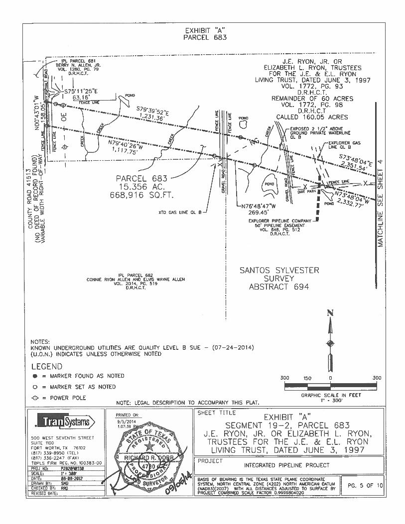
Parcel 683Integrated Pipeline Project
Page 1 of 10
EXHIBIT “A”Property Description
Being 15.356 acres (668,916 square feet) of land situated in the Santos Sylvester Survey,Abstract Number 694, Henderson County, Texas, and more particularly that certain remainder of60 acres conveyed to J.E. Ryon, Jr. or Elizabeth L. Ryon, Trustees for the J.E. & E.L. RyonLiving Trust, dated June 3, 1997 by deed recorded in Volume 1772, Page 93, Deed Records ofHenderson County, Texas (D.R.H.C.T.) and that certain 160.05 acre tract conveyed to J.E. Ryon,Jr. or Elizabeth L. Ryon, Trustees for the J.E. & E.L. Ryon Living Trust, dated June 3, 1997 bydeed recorded in Volume 1772, Page 98, D.R.H.C.T., and being further described as follows:
COMMENCING at the Northwesterly corner of that certain tract of land conveyed to Veterans’Land Board of the State of Texas by deed recorded in Volume 839, Page 410, D.R.H.C.T., beingin the Easterly line of said Ryon Living Trust tract and being in the Easterly line of said SantosSylvester Survey and the Westerly line of the Samuel Moss Survey, Abstract Number 477, fromwhich a found 1/2 inch iron rod bears S 79°25’14” E, 2.41 feet;
THENCE $ 00°44’50” E, along the Westerly line of said Veterans’ Land Board of the State ofTexas tract and the Easterly line of said Ryon Living Trust tract, and along the Westerly line ofsaid Samuel Moss Survey and the Easterly line of said Santos Sylvester Survey, a distance of529.31 feet to a set 5/8 inch iron rod with TranSystems cap for the Northeasterly corner andPOINT OF BEGINNING of the tract herein described (N: 6,743,737.368, E: 2,769,582.766Grid);
(1) THENCE S 00°44’50” E, continuing along the Westerly line of said Veterans’ Land Board ofthe State of Texas tract and the Easterly line of said Ryon Living Trust tract, and the Westerlyline of said Samuel Moss Survey and the Easterly line of said Santos Sylvester Survey and alongthe Easterly line of the tract herein described, a distance of 152.58 feet to a set 5/8 inch iron rodwith TranSystems cap for the Southeasterly corner of the tract herein described;
(2) THENCE N 89°22’23” W, departing the Westerly line of said Veterans’ Land Board of theState of Texas tract and the Easterly line of said Ryon Living Trust tract, and the Westerly line ofsaid Samuel Moss Survey and the Easterly line of said Santos Sylvester Survey and along theSoutherly line of the tract herein described, a distance of 63.40 feet to a set 5/8 inch iron rod withTranSystems cap for an angle point;
(3) THENCE S 85°19’26” W, continuing along the Southerly line of the tract herein described, adistance of 316.66 feet to a set 5/8 inch iron rod with TranSystems cap for an angle point;
(4) THENCE S 79°51’l4” W, continuing along the Southerly line of the tract herein described, adistance of 176.55 feet to a set 5/8 inch iron rod with TranSystems cap for an angle point;
(5) THENCE N $8°01 ‘39” W, continuing along the Southerly line of the tract herein described, adistance of 136.85 feet to a set 5/8 inch iron rod with TranSystems cap for an angle point;
(6) THENCE N 73°48’04” W, continuing along the Southerly line of the tract herein described, adistance of 2,332.77 feet to a set 5/8 inch iron rod with TranSystems cap for an angle point;

Parcel 683Integrated Pipeline Project
Page 2 of 10
(7) THENCE N 76°48’47” W, continuing along the Southerly line of the tract herein described, adistance of 269.45 feet to a set 5/8 inch iron rod with TranSystems cap for an angle point;
(8) THENCE N 79°40’26” W, continuing along the Southerly line of the tract herein described, adistance of 1,117.75. feet to a set 5/8 inch iron rod with TranSystems cap in the Westerly line ofsaid Ryon Living Trust tract and the Easterly line of that certain tract of land conveyed to BerryN. Allen, Jr. by deed recorded in Volume 1280, Page 79, D.R.H.C.T. and being within CountyRoad 41513, No Deed of Record found (variable width right-of-way), being the Southwesterlycorner of the tract herein described;
(9) THENCE N 00°43’Ol” W, along the Westerly line of said Ryon Living Trust tract and theEasterly line of said Allen tract within County Road 41513 and along the Westerly line of thetract herein described, a distance of 158.05 feet to a set 5/8 inch iron rod with TrauSystems capfor the Northwesterly corner of the tract herein described;
(10) THENCE 5 75° 11 ‘25” E, departing the Westerly line of said Ryon Living Trust tract and theEasterly line of said Allen tract and said County Road 41513 and along the Northerly line of thetract herein described, distance of 63.16 feet to a set 5/8 inch iron rod with TranSystems cap foran angle point;
(11) THENCE S 79°39’52” E, continuing along the Northerly line of the tract herein described, adistance of 1,231.36 feet to a set 5/8 inch iron rod with TranSystems cap for an angle point;
(12) THENCE S 73°48’04” E, continuing along the Northerly line of the tract herein described, adistance of 2,351.54 feet to a set 5/8 inch iron rod with TranSystems cap for an angle point;
(13) THENCE S 84°13’52” E, continuing along the Northerly line of the tract herein described, adistance of 153.01 feet to a set 5/8 inch iron rod with TranSystems cap for an angle point;
(14) THENCE N 89°40’4l” E, continuing along the Northerly line of the tract herein described, adistance of 142.49 feet to a set 5/8 inch iron rod with TranSystems cap for an angle point;
(15) THENCE N 79°07’43” E, continuing along the Northerly line of the tract herein described, adistance of 177.98 feet to a set 5/8 inch iron rod with TranSysterns cap for an angle point;
(16) THENCE N 88°31’lO” E, continuing along the Northerly line of the tract herein described, adistance of 291.67 feet to the POINT OF BEGINNING, containing 15.356 acres (668,916square feet) of land, more or less.

Parcel 683Integrated Pipeline Project
Page 3 of 10
NOTE: Basis of bearing is the Texas State Plane Coordinate System, North Central Zone (4202),North American Datum 1983 (NAD 83)(2007) with all distances adjusted to surface by projectcombined scale factor of 0.9999804020.
NOTE: Plat to accompany this legal description.
I do certify on this 5th day of September, 2014, to Attorney’s Title Company of HendersonCounty, Fidelity National Title Insurance Company and Tarrant Regional Water District, that asurvey was made on the ground as per the field notes shown on this survey and is true andcorrect according to the standards of the Texas Society of Professional Surveyors Standards andSpecifications for a Category 2, Condition IV Survey, and accurate as to the boundaries andareas of the subject property and the size, location and type of buildings and improvements, ifany, and shows the location of all visible easements and rights-of-way and the rights-of-way,easements and other matters of record as listed in Schedule B of the Commitment for Title issuedby Fidelity National Title Insurance Company, with an effective date of August 3, 2012, issueddate of August 14, 2012, Gf # 12-476-DD affecting the subject property and listed in Exhibit“A-I” attached hereto.
Except as shown on the survey: (i) there are no visible encroachments upon the subject propertyby visible improvements on adjacent property, (ii) there are no visible encroachments onadjacent property, streets or alleys by any visible improvements on the subject property, and (iii)there are no visible conflicts or discrepancies.
This survey substantially complies with the current Texas Society of Professional SurveyorsStandards and Specifications for a Category 2, Condition IV Survey.
Richard R. DorrRegistered Professional Land SurveyorTexas Registration Number 4780 60
Dated:___________________

N
NOTES:UNDERGROUND UTILITIES SHOWN ARE QUALITY LEVEL B SUE — (07—24—2014)(U.O.N.) INDICATES UNLESS OTHERWISE NOTED
LEGEND• = MARKER FOUND AS NOTED 300 150 0 300
o = MARKER SET AS NOTED IGRAPHIC SCALE IN FEET
1” • 300
SHEET TITLEEXHIBIT “A”
SEGMENT 19—2, PARCEL 683J.E. RYON, JR. OR ELIZABETH L. RYON,TRUSTEES FOR THE J.E. & E.L. RYON
LIVING TRUST, DATED JUNE 3, 1997PRDJECT
INTEGRATED PIPELINE PROJECT
BASIS OF BEARING IS THE TEXAS STATE PLANE COORDINATESYSTEM, NORTH CENTRAL ZONE (4202) NORTH AMERICAN DATUM 4 OF 1 0(NAO83)(2007) WITH ALL DISTANCES ADJUSTED TO SURFACE BYPROJECT COMBINED SCALE FACTOR 0.9999804020
EXHIBIT “A”PARCEL 683
SANTOS SYLVESTERSURVEY
ABSTRACT 694 J. E. RYON, JR. ORELIZABETH L. RYON,
TRUSTEES FOR THE J.E. & E.L.RYON LIVING TRUST, DATED JUNE 3, 1997
VOL. 1772, PG. 93D . R .H .C.T.
REMAINDER OF 60 ACRESVOL. 1772, PG. 98
D.R.H.C.TCALLED 160.05 ACRES
SAMUEL MOSS—SURVEY
ABSTRACT 477
/
UNE /
BEARS S79’25’14
vy
IP
PARCEL 683 —
15.356 AC.668,916 SQ.FT. N
2
S7951’14”W176.55’
IPL PARCEL 685JOHN WILLIAM VJLLAGRAN
AND WIFE. JEANENE V1LLAGRANVOL. 1268, PG. 612
D.R.H.C.T.
-& = POWER POLENOTE: LEGAL DESCRIPTION TO ACCOMPANY THIS PLAT.
•ysmsms500 WEST SEVENTH STREETSUITE 1100FORT WORTH, TX 76102(817) 339-8950 (TEL)(817) 336-2247 (FAX)
3:
a
0-0z
• = MARKER FOUND AS NOTED
o = MARKER SET AS NOTED
= POWER POLE
300 150 0 300
EXHIBIT “A”
PARCEL 683
PONDIS7.1 1’25”E
6116’FENCE
__: PC PARCEL 681BERRY N. ALLEN, JR.
J.E. RYON, JR. OR
VOL. 1280, PG. 79 ELIZABETH L. RYON, TRUSTEES
I I••-•- FOR THE J.E. & E.L. RYON
LIVING TRUST. DATED JUNE 3 1997VOL. 1772. PG. 93
D.R.H.C.T.
____
REMAINDER OF 60 ACRESVOL. 1772, PG. 98
D.R.H.C.TCALLED 160.05 ACRESPOND
SQ. FT.
jC
DLOLE. I
—
— tz .-
- coc.,
Oci::ix
U>- 0-
3:
D w wo
cjO
Cix
EXPOSED 2 1/2” ABOVEGROUND PRIVATE WATERLINE01. B
PARCEL
1 5.356
668,916
XTO GAS LINE OL B IEXPLORER PIPELINE COMPANY 1
5O PIPELINE EASEMENTVOL. 648. PG. 512
0. R.H.C .1.
IPL PARCEL 682CONNIE RYON ALLEN AND ELVIS WAYNE ALLEN
VOL. 2014. PG. 519D.R.H.C.T.
wz
-JIU
SANTOS SYLVESTER
SURVEY
ABSTRACT 694
LEGEND
NOTES:
KNOWN UNDERGROUND UTILITIES ARE QUALITY LEVEL B SUE — (07—24—2014)
(U.O.N.) INDICATES UNLESS OTHERWISE NOTED
N
NOTE: LEGAL DESCRIPTION TO ACCOMPANY THIS PLAT.
GRAPHIC SCALE IN FEET1 300
SHEET TITLEPRINTED ON:EXHIBIT “A”•• .ii13yste’ 9/5/2014
SEGMENT 19—2, PARCEL 6831 0739 P
500 WEST SEVENTH STREETTRUSTEES FOR THE J.E. & E.L. RYON
cjb’
J.E. RYON, JR. OR ELIZABETH L. RYON,
SUITE 1100
I * LIVING TRUST, DATED JUNE 3, 1997FORT WORTH, TX 761021817) 339-8950 (TEL)1817) 336-2247 (FAX) , PROJECT
INTEGRATED PIPELINE PROJECTPROJ NO: P200330TBPLS FIRM REC. NO. 100383-00
BASIS OF BEARING IS THE TEXAS STATE PLANE COORDINATE ISCALE: V’ 30WDATE: 08-08-2012
5 OF 10DRAWN BY: SNO * SYSTEM. NORTH CENTRAL ZONE (4202) NORTH AMERICAN DATUM ICHECKED BY: RRD (NAD83(2O07 WITH ALL DISTANCES ADJUSTED TO SURFACE BY I
ROJEC’1 COUINED SCALE FACTOR O.ggggBo4o2o IREVISED DATE:

Parcel 698.1Integrated Pipeline Project
Page I of7
EXHIBIT “A”Property Description
Being 6.047-acres (263,413 square feet) of land situated in the F. Brown Survey, AbstractNumber 81 and in the W. Francher Survey, Abstract Number 224, Henderson County, Texas,and more particularly that certain 92.7 acre tract described as First Tract and that certain 160 acretract described as Third Tract conveyed to Richard W. Alders and Johnyce Alders, in Trust, asTrustees of the Richard and Johnyce Alders Trust (undivided 1/2 interest), by instrumentrecorded in Volume 2311, Page 14, Henderson County Real Property Records, (I-LC.R.P.R.), andbeing more particularly described in Volume 632, Page 637, Henderson County Deed Records,(H.C.D.R.), and being that certain 92.7 acre tract described as First Tract and that certain 160acre tract described as Third Tract conveyed to Charles A. Alders orJo Ann Alders, Trustees forthe Alders Living Trust, dated July 30, 7990 (undivided 1/2 interest), by instrument recorded inVolume 2142, Page 773, H.C.R.P.R., and being more particularly described in said Volume 632,Page 637, and being further described as follows:
COMMENCING at a rock found for the northeast corner of that certain tract described asSecond Tract conveyed to Warren Hendry, by instrument recorded in Volume 241, Page 362,H.C.D.R., said rock being the most easterly southeast corner of that certain tract described asThird Tract conveyed to Triple S Ranch, Inc., by instrument recorded in Filing No. 13485600with the Texas Secretary of State Office, and being further described by instrument recorded inVolume 500, Page 418, H.C.D.R., said rock being in the west line of that certain tract conveyedto Gregory William Jackson and Gina Gentry Jackson, by instrument recorded in DocumentNumber 201 0-00008334, Henderson County Real Property Records, (H.C.R.P.R.), said rock alsobeing in the east line of said Abstract Number 81, said rock also being in the west line of saidAbstract Number 224, from which a 1 inch metal post found for reference bears North 01 degree37 minutes 43 seconds West, a distance of 408.52 feet;
THENCE South 00 degrees 47 minutes 27 seconds West, along the common line of said Hendrytract, said Jackson tract, said Abstract Number $1, and said Abstract Number 224, a distance of672.22 feet to a point for the southeast corner of said Flendry tract, said point being the northeastcorner of said First Tract;
THENCE South 64 degrees 02 minutes 27 seconds West, along the common line of said Hendrytract and said First Tract, a distance of 733.33 feet to a point for the southwest cornet of saidHendry tract, said point being the northwest corner of said First Tract, said point also being themost easterly corner of that certain tract conveyed to Triple S Ranch, Inc., by instrumentrecorded in Volume 806, Page 894, H.C.D.R., and being further described in Volume 155, Page184, H.C.D.R.;
THENCE South 16 minutes 02 minutes 27 seconds West, along the common line of said TripleS. Ranch, Inc. tract and said first Tract, a distance of 337.84 feet to a 5/8 inch iron rod with capstamped “GORRONDONA” set for the POINT OF BEGINNING (N:6,740,569.795,E:2,7$l ,723.876 Grid);
Parcel 698.1Integrated Pipeline Project
Page 2 of 7
(1) THENCE South 75 degrees 08 minutes 54 seconds East, a distance of 322.2$ feet to a 5/8 inchiron rod with cap stamped “GORRONDONA” set for corner;
(2) THENCE South 78 degrees 39 minutes 47 seconds East, a distance of 460.60 feet to a 5/8 inchiron rod with cap stamped “GORRONDONA” set for corner;
(3) THENCE South 85 degrees 41 minutes 53 seconds East, a distance of 460.38 feet to a 5/8 inchiron rod with cap stamped “GORRONDONA” set for corner;
(4) THENCE South $9 degrees 12 minutes 5% seconds East, a distance of 480.20 feet to a 5/8 inchiron rod with cap stamped “GORRONDONA” set for corner in the northwesterly right-of-waytine of F.M. Highway 753 (an 80’ right-of-way) (no deed of record found), from which a 1 inchiron pipe found for an interior corner of that certain tract described as Tract One conveyed toMill Run Farms, Inc., a Texas corporation, by instrument recorded in Volume 1180, Page 187,H.C.R.P.R. bears North 81 degrees 48 minutes 22 seconds East (radial bearing), a distance of2905.37 feet, said 1 inch iron pipe being the southeast corner of the R.H.& H.T. Alders Survey,Abstract Number 1225, Henderson County, Texas, said 1 inch iron pipe being the southwestcorner of the G. Reeves Survey, Abstract Number 928, Henderson County, Texas, said 1 inchiron pipe being in the north line of the S. Jones Survey, Abstract Number 961, HendersonCounty, Texas;
(5) THENCE South 39 degrees 39 minutes 54 seconds West, along the northwesterly right-of-wayline of said F.M. Highway 753, a distance of 192.63 feet to a 5/8 inch iron rod with cap stamped“GORRONDONA” set for corner;
(6) THENCE North 89 degrees 13 minutes 15 seconds West, a distance of 637.75 feet to a 5/8 inchiron rod with cap stamped “GORRONDONA” set for corner;
(7) THENCE North $1 degrees 53 minutes 55 seconds West, a distance of 436.42 feet to a 5/2 inchiron rod with cap stamped “GORRONDONA” set for corner;
(8) THENCE North 75 degrees 37 minutes 40 seconds West, a distance of 570.84 feet to a 5/8 inchiron rod with cap stamped “GORRONDONA” set for corner in the northwesterly line of saidFirst Tract, said point being in the southeasterly line of said Triple S. Ranch, Inc. tract;
(9) THENCE North 16 degrees 02 minutes 27 seconds East, along the common line of said FirstTract and said Triple S. Ranch, Inc. tract, a distance of 156.79 feet to the POINT OfBEGINNING and containing 6.047-acres (263,413 square feet) of land, more or less.
Parcel 698.]Integrated Pipeline Project
Page 3 of7
NOTE: Basis of bearing is the Texas State Plane Coordinate System, North Central Zone (4202) NorthAmerican Datum (NAD83)(2007) with all distances adjusted to surface by project combinedscale factor 0.9999804020.
NOTE: Plat to accompany this legal description.
I do certify on this 13th day of September, 2013, to Attorney’s Title Co Of Henderson County, FidelityNational Title Insurance Company, Tarrant Regional Water District, that a survey was made on theground as per the field notes shown on this survey and is true and correct according to the standards ofthe Texas Society of Professional Surveyors Standards and Specifications for a Category 2, ConditionIV Survey, and accurate as to the boundaries and areas of the subject property and the size, location andtype of buildings and improvements, if any, and shows the location of all visible easements and rights-of-way and the rights-of-way, easements and other matters of record as listed in Schedule B of theCommitment for Title issued by Fidelity National Titte Insurance Company, with an effective date ofFebruary 20, 2013, issued date of February 26, 2013 GF # 12-71 1-DD affecting the subject property andlisted in Exhibit “A-I” attached hereto.
Except as shown on the survey: (1) there are no visible encroachments upon the subject property byvisible improvements on adjacent property, (ii) there are no visible encroachments on adjacent property,streets or alleys by any visible improvements on the subject property, and (iii) there are no visibleconflicts or discrepancies.
This survey substantially complies with the current Texas Society of Professional Surveyors Standardsand Specifications for a Category 2, Condition IV Survey.
-________
Chris T. AbbottRegistered Professional Land SurveyorTexas Registration No. 6407
/ /Dated: —

PC PARCEL 694 ‘1”‘ —
TRPtE S RANCH, NC SVOLUME 806. PAGE 894 O —
H.CDRFURTHER DESCRIBED IN ‘
VOLUME 155, PAGE 184 VH C OP.
S 16’02’27” W337.84 J S 75’08’54” E
P.0.B. / 322,28’PARCEL 696 1
N6 740 569 795 -‘ 78’39’E 2.78’,72387 ‘e—._4664” E
N 16’0227” E J156.79’ I 7’5’3’.,
t’s.\ J7O.6 WN
436.4
RICHARD W. ALDERS AND/ JOHNYC E ALDERS, IN TRUST.
AS TRUSTEES OF THERICHARD AND JOHNYCE ALDERS TRUST
/ (UNDIVIDED 1/2 INTEREST)VOLUME 2311. PAGE 14, H.C..P.R.
C HARLES A. ALDERS OR 10 ANN ALDERS,TRUSTEES FOR THE ALDERS LMNG TRUST1
DATED JULY 30, 1990(UNDIVIDED 1/2 INTEREST)
VOLUME 2142, PAGE 773, H.C.R.P.R.BEING FURTHER DESCRIBED
AS FIRST TRACTVOLUME 632, PAGE 637, H.C.D.R. /
REMAINDER CF /1’CALLED 92.7 ACRES 1/I
KNOWN UNDERGROUND UT.LmES SHOWNARE QUALITY LEVEL B SUE (02/15/2013)LEGAL DESCRIPTION TO ACCOMPANY THIS PLAT
GORRONDONA &ASSOCiATES, INC.
‘L4 JACK NLWEZ.L BLVD SOUTHrOll V,CfOH, TEXAS 76118P IO’L 8 1)4%—I 4241AX I81?)4G6—li6I
P5:11 Kr’
-S 3939’54” W192.63’
UVRtD SPRINT tAlELEVEL 9 SUE
RICHARD W. ALDERS AND-’]OHNYCE ALDERS, IN TRUST.
AS TRUSTEES OF THEHARD AND JOHNYCE ALDERS TRUST
(UNDMDED 1/2 INTEREST)VOLUME 2311, PAGE 14, H.C..P.R.
C HARLES A ALDERS ORJO ANN ALDERS,
TRUSTEES FOR THE ALDERS LMNG TRUSDATED JULY 30, 1990
(UNDMDED 1/2 INTEREST)VOLUME 2142, PAGE 773, H.C.R.P.R.
BEING FURTHER DESCRIBEDAS THIRD TRACT
VOLUME 632, PAGE 637. H.C.D.R.REMAINDER OF
CALLED 160 ACRES400 200 0
FOUNDI’ METAL POST
F’.1
C
P1. PARCEL £94THIRD TRACT
TRIPLE S RANCH, INCCLING NUMBER
13495600TEXAS SECRETARt’OF STATE OFCCE
FR’HER DESCIBED INVOLUME 500. PAGE 418
NC DR
EXHIBIT “A”PARCEL 698.1
zr.o.c.
D ROCK
‘ F.
LEGEND• = MARKER FOUND AS NOTED
o = 5/8” IRS WITH CAPSTAMPED GORPONDQNA”
G= POWER POLE
BROWN SURVEYABSTRACT 81
\SECOND TRACT
WARREN HENORYVOLUME 241. PAGE 362
H COP.
DETAIL A”NOT TO SCALE
F’.
CC
W. FRANC HER SURVEYABSTRACT 224
FL PARCEL 697GREGORY W:CL!AM JACKSONAND ONA GENTRY JACKSON
DOCUMENT TAO 2010—00008334H C .R PR
/ ‘E’I’:E . NE
\
PARC EL6.047
263,413
696.1AC.SQ.FT.
S 85’4’,3” E
N8
I
rT’IET lNF.
/
NOTE:
NOTE:
N
400
GNAPHIC SCALE IN FLEE1’ 405’
SCALE I = 400’DATE 09—13—2013TINAWN iv: CACNEC%EO eY. cREVISED DATE 09—24—201.1 - —
SHEET TITt.EXHIBIT “A” SEGMENT 19—2,
PARC EL 698.1RICHARD W. ALDERS
AND JOHNYCE ALDERS TRUSTEESCHARLES A. ALOERS
OR JO ANN ALDERS, TRUSTEESPROJECT
INTEGRATED PIPELINE PROJECT
BASIS OF BEAR HG IS THE TEXAS STATE PLANE COORDINATES’YSTEM NORTH CENTRAL ZONE (4202) NORTH AMERICAN DATUM(NAD3Sf2OO7) WITH AL OISTANCES AOJUSTED TO SURFACEPROJECT COMB ‘NED SCALE FACTOR 0 9999804020

IPL PARCEL 6962RICHARD W. ALDERS AND ICHNYCE ALDERS,
N TRUSt, AS TRUSTEES OF 1HRICHARD AND JONNYCE ALDERS TRUST
(UNDiVIDED 1/2 INTEREST)VOLUME 2311, PACE 14
HC.R,P PCHARLES A. AS..DERS OR JO ANN ALDERS.TRUSTEES FOR THE ACERS LyING TRUST.
DATED JULY 30. 1Q90(]NDVIOED 1/2 INTEREST)VOLUME 2142. PACE 773
H CR.P.RBEING FURTHER DESCRED AS T,-LRD TRACT
VCLUME 632, PACE 637H C.D P
REMANDER OFCALLED 160 ACRES
IPL PARCEL 6982R.C HARD W ALDERS
AND JONNYCE ALDERS,IN TRUST. AS TRUSTEES
OF THE RICHARD ANDJONNYCE ALOERS TRUST(JNDUI’DED 1/2 INTEREST)YO.IJUE 2311. PAGE 14
HCRPR.CHARSS A ALDERS OR
JO ANN ALDERS.TRUSTEES FOR THE
ALDERS LIVING TRUST.DATED JULY 3D, 1990
(UNDIVIDED 1/2 UTEREST)VOLUME 2142, PASE 773
H C P PRDEING FURThER DESCRIBED
AS STTENTH TRACT
_______
VOLUME 632, PAGE 637H.C OR,
REMAINDER OFCALLED 641.5 ACRES
S. JONES SURVEYABSTRACT 961
LEGEND• = MARKER FOUND AS NOTED
4C0 20-0 0
N
GORRONDONA &ASSOCIATES, INC.7524 JACN NEWW. BLVD. SOUTHFORT WO’H, TEXAS 76118PIlr)NE (81 ?)4cT6—1424fAX (817)498—1168
(RAPHC SDA.E III FEET1” 400’
EXHBIT “A”PARCEL 698.1
R.H. & H.TALDERS
• SURVEYAB STRAC T
1225— — — — — — — — * — — — — — 1/2’ SCUARE
IRON BAR
o = 5/8” IRS WITH CAPSTAMPED GORRONDONA
e- = POWER POLE
C. REEVES SURVEYABSTRACT 928
W. FRANC HER SURVEY
STRACT
224
UiUi
UI
UiUiUI
‘PP 91JR,tV c1u.
/WATER
P1. PARCEL 702TRACT ONE
MILL RUN rA.Rus. INC.,A TEXAS CORPORATON
VOLUME uSC, PAGE 187H C,R P.R
NOTE; KNOWN UNDERGROUND UTILITIES SHOWNARE QUALITY LEVEL B SUE (02/15/2013)
NOTE: LEGAL DESCRIPTION TO ACCOMPANY THIS P).AT
PROJ NO. P207090320SCALE 1’ 400’BATE. 09—13—2013CRAN BY. CAtHSC1CED BY. ]CREVISED DATE 09—24—2013
E.HE El TIT..E
EXHIB IT “A” SEGMENT 1 9—2,PARCEL 698.1
RtC HARD W. ALDERSAND JOHNYCE ALDERS TRUSTEES
CHARLES A. ALóERSOR JO ANN ALDERS, TRUSTEES
PROJECTINTEGRATED P’PELINE PROJECT
BASIS OF BEARFIG 15 THE TEXAS STATE PLANE COORONATESYSTEM. NORTH CENTRAL ZONE (4202) NORTH AMERICAN OATUU(NAD83)(2007) wiTh ALL DISTANCES ADJUSTED TO SURFAE y 3.
PRO.JECT COMBINED SCALE FACTOR 09999804020

Parcel 698.2Integrated Pipeline Project
Page 1 of5
EXHIBIT A”Property Description
Being 10.053-acres (437,915 square feet) of land situated in the W. Francher Survey, AbstractNumber 224 and in the S. Jones Survey, Abstract No. 961, Henderson County, Texas, and moreparticularly that certain 160 acre tract described as Third Tract and that certain 641.5 acre tractdescribed as Seventh Tract conveyed to Richard W. Alders and Johnyce Alders, in Trust, asTrustees of the Richard and Johnyce Alders Trust (undivided 1/2 interest), by instrumentrecorded in Volume 2311, Page 14, Henderson County Real Property Records, (H.C.R.?.R.), andbeing more particularly described in Volume 632, Page 637, Henderson County Deed Records,(H.C.D.R.), and being that certain 160 acre tract described as Third Tract and that certain 641.5acre tract described as Seventh Tract conveyed to Charles A. Alders or J0 Ann Alders, Trusteesfor the Alders Living Trust, dated July 30, 1990 (undivided 1/2 interest), by instrument recordedin Volume 2142, Page 773, H.C.R.P.R., and being more particularly described in said Volume632, Page 637, and being further described as follows:
COMMENCING at a 1 inch iron pipe found for an interior corner of that certain tract describedas Tract One conveyed to Mill Run Farms, Inc., a Texas corporation, by instrument recorded inVolume 1180, Page 187, H.C.R.P.R., said 1 inch iron pipe being in the most northerly north lineof said Alders tract, said 1 inch iron pipe being the southeast corner of the R.H.& H.T. AldersSurvey, Abstract Number 1225, Henderson County, Texas, said 1 inch iron rod being thesouthwest corner of the G. Reeves Survey, Abstract Number 928, Henderson County, Texas, said1 inch iron pipe also being in the north line of said Abstract Number 961;
THENCE South 09 degrees 33 minutes 02 seconds East, along the westerly tine of said TractOne, a distance of 460.96 feet to a 5/8 inch iron rod with cap stamped “GORRONDONA” set forthe POINT OF BEGINNING (N:6,740,315.047, E:2,7$6,378.344 Grid);
(1) THENCE South 09 degrees 33 minutes 02 seconds East, along the westerly line of said TractOne, a distance of 152.08 feet to a 5/8 inch iron rod with cap stamped “GORRONDONA” set forcorner, from which a 1/2 inch iron rod found for an angle point in the westerly line of said TractOne bears South 09 degrees 33 minutes 02 seconds East, a distance of 788.32 feet;
(2) THENCE North 89 degrees 13 minutes 15 seconds West, a distance of 2997.89 feet to a 5/8inch iron rod with cap stamped “GORRONDONA” set for corner in the southeasterly right-of-way line of F.M. Highway 753 (an $0’ right-of-way) (no deed of record found);
(3) THENCE North 39 degrees 39 minutes 54 seconds East, with the southeasterly right-of-way lineof said F.M. Highway 753, a distance of 192.62 feet to a 5/8 inch iron rod with cap stamped“GORRONDONA” set for corner;
(4) THENCE South $9 degrees 12 minutes 52 seconds East, a distance of 2849.71 feet to thePOINT OF BEGINNING and containing 10.053-acres (437,915 square feet) of land, more orless.

Parcel 698.2Integrated Pipeline Project
Page 2 of 5
NOTE: Basis of bearing is the Texas State Plane Coordinate System, North Central Zone (4202) NorthAmerican Datum (NAD83)(2007) with all distances adjusted to surface by project combinedscale factor 0.9999804020.
NOTE: Plat to accompany this legal description.
I do certify on this 13th day of September, 2013, to Attorney’s Title Co Of Henderson County, fidelityNational Title Insurance Company, Tarrant Regional Water District, that a survey was made on theground as per the field notes shown on this survey and is true and correct according to the standards ofthe Texas Society of Professional Surveyors Standards and Specifications for a Category 2, ConditionIV Survey, and accurate as to the boundaries and areas of the subject property and the size, location andtype of buildings and improvements, if any, and shows the location of all visible easements and rights-of-way and the rights-of-way, easements and other matters of record as listed in Schedule B of theCommitment for Title issued by fidelity National Title Insurance Company, with an effective date offebruary 20,2013, issued date of February 26, 2013 GF # 12-71 l-DD affecting the subject property andtisted in Exhibit “A-i” attached hereto.
Except as shown on the survey: (1) there are no visible encroachments upon the subject property byvisible improvements on adjacent property, (ii) there are no visible encroachments on adjacent property,streets or alleys by any visible improvements on the subject property, and (iii) there are no visibleconflicts or discrepancies.
This survey substantially complies with the current Texas Society of Professional Surveyors Standardsand Specifications for a Category 2, Condition IV Survey.
-
________
Chris T. Abbott
____________
Registered Professional Land Surveyor CHRiS I. ABBOUTexas Registration No. 6407 640?
0Dated: / / SUP

W. FRANC HER SURVEYABSTRACT 224
IRL PARCEL 697 1//.’ ?‘GREGORY WILLIAM JACKSON / t. 4 0AND GINA GENTRY JACKSON /
DOCUMENT NO. 2010 00008334 /H.CR.P.R. ,. 6,
W. FRANCHER SURVEY1 / ABSTRACT 224
PARCEL 698.2N 3939’54” E / ENCE INE\ / 1 0.053 AC.
192.62’ ‘ 437,915 SQ.E.BURIED SPRINT CUE
LEVEL B SUE
S 89’12’52’ E 2549,71’
DETAIL “A”
a a S — a a —is. .e.., S — R nasa
/ N 69’13’15” W 2997,89’
RICHARD W. ALDERS AND JOHNYCE ALDERS,IN TRUST, AS TRUSTEES OF THE
RICHARD AND JOHNYCE ALDERS TRUST‘e , (UNDIVIDED 1 /2 INTEREST)
VOLUME 2311. PACE 14, H.C.R.P.R.CHARLES A. ALDERS OR JO ANN ALDERS,TRUSTEES FOR THE ALDERS LIVING TRUST,
DATED JULY 30, 1990(UNDIVIDED 1/2 INTEREST)
VOLUME 2142, PACE 773, H.C.R.P.R.BEING FURTHER DESCRIBED AS THIRD TRACT
VOLUME 632, PACE 637, H.C.D.R.REMAIN:)ER OF
CALED 160 ACRES
SLIWtY4N
— DETML “A” RICHARD W. ALDERS AND JORNYCE ALDERS,NOT W SCALE IN TRUST, AS TRUSTEES OF THE
RCHARD AND JOHNYCE ALDERS TRUST(UNDIVIDED 1/2 INTEREST)
VOLUME 2311, PAGE 14, H.C.R.P.R.CHARLES A. ALDERS OR JO ANN ALDERS,TRUSTEES FOR THE ALDERS LIVING TRUST,
)ATEO JULY 30, 1990(UNDIVIDED 1/2 INTEREST)
VOLUME 2142, PAGE 773, H.C.R.P.R.BEING FURTHER DESCR6ED AS SEVENTH TRACT
VOLUME 632, PAGE 637, H.C.D.R.REMAINDER OF
“ CALLED 641.5 ACRESNOTE: KNOWN UNDERGROUND UT CITIES SHOWN
ARE OUALITT LEVEL SUE (02/15/2013)NOTE: LEGAL DESCRIPTION O ACCOMPANY THIS PLA”
EXHBIT “A”PARCEL 698.2
LEGEND• = MARKER FOUND AS NOTED
o 5/8” IRS WITH CAPSTAMPED “GORRONDONA”
-0- = POWER POLE
.H. & H.T.1ALDERS I G. REEVESSURVEY SURVEY
ABSTRACTt ABSTRACT 9281225 I
to’ TRAIL
P.0.8.
•.n
PARCEL 6982N—6.740.3 15.047E2.756,378.344(GRID)
S 09’33’02” E152.08’
I I/Il PC PARCEL 702I IRACT ONE
MILL RUN FARMS, INC‘“
• A TEXAS CORPORATIONc”1 VOLUME 1180. PAGE 187
H.C P.1’ R.
1/2” PF
S. JONES SURVEYABSTRACT 961
500 250 0—------—-—-
GORRONDONA &ASSOCIATES, INC.
PR’TED G’.
CR l9/2C139 (iii CC
GRAPHIC SCALE IN FEET1” = 500
7524 JAck NE.WCIL BLVD SOUTHFORT WORTH, TEXAS /6118PHUNS (8: 7)496— 1 424FAX (817)496—1768
PROJ M) P202033flSCALE 1” S0ODATE 09—13—2013DRAWN ICY. CACHECXEI) BY; ICREWITD GATE Cg—l9—20u —
SHEET TIILEEXHIB T “A” SEGMENT 1 9—2,
PARCEL 698.2RC HARD W. ALDERS
AND JOHNYCE ALDERS TRUSTEESCHARLES A. ALOERS
OR JO ANN ALDERS, TRUSTEESPROJECT
NTEGRAIED PIPELINE PROJECT
BASIS OF BEARING S THE TEXAS STATE PLANE COORO NATESYStEM NORTH CENTRAL ZONE (4202) NORTH AMERICAN DATUMCNADB3S(2007) WITH ALL DISTANCES AOJUSTED TO SURFACE BY ‘- “
RROJECY COMB NED SCALE FACTOR 0.9999804020

Parcel 893Integrated Pipeline Project
Page 1 of5
EXHIBIT “A1’Property Description
Being 1.567 acres (68,252 square feet) of land out of the John Williams Survey, AbstractNumber 877, Navarro County, Texas, and more particularly that certain 10.13 acre tract of landconveyed to Joe L. White and wife, Velma B. White by deed recorded in Volume 1410, Page203, Deed Records, Navarro County, Texas (D.R.N.C.T.), and being further described asfollows:
COMMENCING at a 1/2 inch iron rod found for the Northwesterly corner of said White tractand being in the existing Southerly right-of-way line of SH 31, No Deed of Record Found (180’wide right-of-way);
THENCE N 78°53’15” E, along the Northerly line of said White tract and the existing Southerlyright-of-way line of said SH 31, a distance of 792.72 feet to a set 5/8 inch iron rod withTranSystems cap for the Northwesterly corner and POINT OF BEGINNING of the tract hereindescribed (N: 6,737,461.041, E: 2,663,851.847 Grid);
(1) THENCE N 78°53’15” 5, continuing along the Northerly line of said White tract and theexisting Southerly right-of-way line of said SH 31, a distance of 153.51 feet to a set 5/8 inch ironrod with TranSystems cap for the Northeasterly corner of the tract herein described;
(2) THENCE S 23°22’55” E, departing the Northerly line of said White tract and the existingSoutherly right-of-way line of said SH 31, and along the Easterly line of the tract hereindescribed, a distance of 15.33 feet to a set 5/8 inch iron rod with TranSystems cap for the pointof intersection with the Easterly line of said White tract and the Westerly line of County Road2240, No Deed of Record Found (variable width);
(3) THENCE S 2105812211 E, along the Easterly line of said White tract and the Westerly line ofsaid County Road 2240 and the Easterly line of the tract herein described, a distance of 110.83feet to a set 51$ inch iron rod with TranSystems cap for an angle point;
(4) THENCE S 19°12’20” E, departing the Easterly line of said White tract and the Westerly line ofsaid County Road 2240 and along the Easterly line of the tract herein described, a distance of328.80 feet to a set 5/8 inch iron rod with TranSystems cap for the point of intersection with theSoutherly line of said White tract and the Northerly right-of-way line of Union Pacific Railroad,No Deed of Record Found (100’ wide right-of-way), and being the Southeasterly corner of thetract herein described;
(5) THENCE S 78°58’59” W, along the Southerly line of said White tract and the existingNortherly right-of-way line of said Union Pacific Railroad, and along the Southerly line of thetract herein described, a distance of 151.55 feet to a set 58 inch iron rod with TranSystems capfor the Southwesterly corner of the tract herein described;

Parcel 893Integrated Pipeline Project
Page2 of 5
(6) THENCE N 19°12’16” W, departing the Southerly line of said White tract and the existingNortherly right-of-way line of said Union Pacific Railroad, and along the Westerty line of thetract herein described, a distance of 303.60 feet to a set 5!$ inch iron rod with TranSystems capfor an angle point;
(7) THENCE N 21°58’22” W, continuing along the Westerly line of the tract herein described, adistance of 105.36 feet to a set 5’8 inch iron rod with TranSystems cap for an angle point;
(8) THENCE N 23°22’55” W, continuing along the Westerly line of the tract herein described, adistance of 46.10 feet to the POINT OF BEGINNING, containing 1.567 acres (68,252 squarefeet) of land, more or less.

Parcel 893Integrated Pipeline Project
Page 3 of 5
NOTE:Basis of bearing is the Texas State Plane Coordinate System, North Central Zone (4202),North American Datum 1983 (NAD 83)(200?) with all distances adjusted to surface by projectcombined scale factor of 0.9999460030.
NOTE:Ptat to accompany this legal description.
I do certify on this 6th day of February, 2015 to WFG National Title Insurance Company, andTarrant Regional Water District, that a survey was made on the ground as per the field notesshown on this survey and is true and correct according to the standards of the Texas Society ofProfessional Surveyors Standards and Specifications for a Category 2, Condition IV Survey, andaccurate as to the boundaries and areas of the subject property and the size, location and type ofbuildings and improvements, if any, and shows the location of all visible easements and rights-of-way and the rights-of-way, easements and other matters of record as listed in Schedule B ofthe Commitment for Title issued by WFG National Title Insurance Company, with an effectivedate of August Ii, 2014, issued date of August 27, 2014, Gf #CTI3-7034-W affecting thesubject property and listed in Exhibit “A-I” attached hereto.
Except as shown on the survey: (i) there are no visible encroachments upon the subject propertyby visible improvements on adjacent property, (ii) there are no visible encroachments onadjacent property, streets or alleys by any visible improvements on the subject property, and (iii)there are no visible conflicts or discrepancies.
This survey substantially complies with the current Texas Society of Professional SurveyorsStandards and Specifications for a Category 2, Condition IV Survey.
Richard R. DorrRegistered Professional Land SurveyorTexas Registration Number 4780
Dated: O2fOcl.4

- 6.737A6TO4t 15 33
N/
£ — 2.563.851.647(GRID) —
—
:: N2Y22’5”W k 6cITYOFKERENScP\_--- P.O_c. 46.10
WATER LINE (DC 0)1’2”IRF
8 CITY OF KERENS,.. WATER LINE (OC 0)
JOE AND WIFE,PARCEL 893
VOL. 1410, PG. 803 1.567 AC. %,CALLED 1013 ACRES \68,252 SQ. FT.
\
/
\/ .\/ ‘.
/ JOHN WILLIAMS SURVEY
ABSTRACT 877
._.-AccC
N
O = MARKER FOUND AS NOTED
O SET 5/8” IRON ROD WITH CAPSTAMPED “TRANSYSTEMS” (U.O.N.)
-0-; POWER POLE
ELECTRIC BOX
-0— STREET SIGN
PRINTED ON SHEET TITLE
•1iystefl) 2/6/2015 EXHIBIT A‘
SEGMENT 16, PARCEL 893500 WEST SEVENTH STREET JOE L. WHITE AND WIFE,
FORT WORTH. TX 76102 ft VELMA B. WHITE(817) 339-8950 (TEL)(817) 336-2247 (FAX) R 0 R. 0 R PROJECTREG. NO. 100383-00
4 0 ! INTEGRATED PIPELINE PROJECTSCALE: I•:I•DATES I1-u8-2I5 tII BASIS OF BEARING IS THE TEXAS STATE PLANE COORDINATEORWN BY: SI. 0 SYSTEM. NORTH CENTRAL ZONE (4202) NORTH AMERICAN DATUM PG 4 OF 5ECVED BY: RRO (NADS3)(2007) WITH AU. DISTANCES ADJUSTED 10 SURFACE BYREVISED 0TE: PROJECT COUINED SCALE FACTOR 0.9999460030
11%To
DETAIL%—
NOTES:KNOWN UNDERGROUND UTILITIES SHOWN AREOUAUW LEVEL B & D SUE — (12—27—2012)(U.0.N.) INDICATES UNLESS OTHERWISE NOTED
LEGEND
MICAJAH AUTREY SURVEYABSTRACT 13
100 50 0
NOTE: LEGAL DESCRIPTION TO ACCOMPANY THIS PLAT.
190
GRAPHIC SCALE IN FEET1” l0O

Parcel 730Integrated Pipeline Project
Page 1 of4
EXHIBIT “A”Property Description
Being a 6.828 acre (297,415 square feet) tract of land situated in the Thomas Hanna Survey,Abstract Number 304, Henderson County, Texas and more particularly that certain 121.5 acretract of land conveyed to Genie Warren, Jr. by instrument recorded in Volume 1926, Page 628,Official Public Records, Henderson County, Texas and being more particularly described asfollows:
BEGINNING at a 5/8-inch iron rod set in the west line of said Warren tract and the east line of atract of land situated in said Hanna Survey conveyed to Lazy W. District No. 1 by instrumentrecorded in Document Number 20 13-00000420, said Official Public Records, from which a 3/8-inch iron rod found for the Northwest corner of said Warren tract and the east most Northeastcorner of a tract of land situated in said Hanna Survey conveyed to Beverly Wilson Smith byinstrument recorded in Volume 1491, Page 222, said Official Public Records bears N 01°19’57”W, a distance of 1,224.64 feet (said POINT OF BEGINNING having coordinates ofN: 6,733,285.974, E: 2,816,820.563 GRID);
(1) THENCE N 89°48’Ol” E, departing the common line of said Warren tract and said Lazy Wtract, over and across said Warren tract, a distance of 1,984.50 feet to a 5/8- inch iron rod set inthe east line of said Warren tract and the west line of a tract of land situated in the PhillipJackson Survey, Abstract Number 392, conveyed to Larry H. Fitzhugh and Karen K. Fitzhugh,husband and wife by instrument recorded in Volume 2100, Page 862, said Official PublicRecords, said 5/8-inch iron rod being within the margins of County Road 4515 (unknown width,no deed of record found);
(2) THENCE S 00°00’27” E, with the common line of said Warren tract and said Fitzhugh tract,within the margins of said County Road 4515, a distance of 150.00 feet to a 5/8-inch iron rod set,from which a 3/4-inch iron pipe found within the margins of said County Road 4515 for theSoutheast corner of said Warren tract bears S 00°00’27” E, a distance of 1,255.57 feet;
(3) THENCE S 89°48’Ol” W, departing the common line of said Warren tract and said Fitzhughtract, over and across said Warren tract, a distance of 1,981.03 feet to a 5/8-inch iron rod set inthe common line of said Warren tract and said Lazy W tract;
(4) THENCE N 01°19’57” W, with the common line of said Warren tract and said Lazy W tract, adistance of 150.03 feet to the POINT OF BEGINNING and containing 6.82$ acres (297,415)square feet) of land, more or less.

Parcel 730Integrated Pipeline Project
Page 2 of 4
NOTE: Basis of bearing is the Texas State Plane Coordinate System, North Central Zone (4202), NorthAmerican Datum 1983 (NAD 83)(2007) with all distances adjusted to surface by projectcombined scale factor of 0.9999804020.
NOTE: Plat to accompany this legal description.
NOTE: All 5/8-inch iron rods set have a yellow cap stamped “SAM INC.”
I do certify on this 30th day of April, 2014, to Attorney’s Title Company of Henderson County, fidelityNational Title Insurance Company and Tarrant RegionaL Water District, that a survey was made on theground as per the field notes shown on this survey and is true and correct according to the standards ofthe Texas Society of Professional Surveyors Standards and Specifications for a Category 2, ConditionIV Survey, and accurate as to the boundaries and areas of the subject property and the size, location andtype of buildings and improvements, if any, and shows the location of all visible easements and rights-of-way and the rights-of-way, easements and other matters of record as listed in Schedule B of theCommitment for Title issued by Fidelity National Title Insurance Company, with an effective date ofMay 6, 2014, issued date of May 13, 2014 GF # 14-293-DD affecting the subject property and listed inExhibit “A-i” attached hereto.
Except as shown on the survey: (1) there are no visible encroachments upon the subject property byvisible improvements on adjacent property, (ii) there are no visible encroachments on adjacent property,streets or alleys by any visible improvements on the subject property, and (iii) there are no visibleconflicts or discrepancies.
This survey substantially complies with the current Texas Society of Professional Surveyors Standardsand Specifications for a Category 2, Condition IV Survey.
Kevin WendellRegistered Professional Land SurveyorTexas Registration Number 5500
Dated: May 30. 2014

U, SURVEYUNE
,P.O.R.RF
BEVERLY WILSON SMITHVOL 1491, PG. 222
O.PR.H.C.T. NU,
a0z
FLE NAME: PARCEL 730.DGNPROJ NO: 032172 TRWD TASK 12SCALE: 1”•400’DATE: 05/22/2013DRAWN BY: CUCHECKED BY: 5KWREVISED DATE:
‘ IPL PARCEL 731‘‘MONIE MONTGOMERY and
LISA MONTGOMERYVOL. 2278. PG. 600
TRACT jII O.P.R.H..T.
>-w>
D
zr’)OH(no
oQ<F—
-J-J
0
PHILLIP JACKSON SURVEYABSTRACT 392
EXHIBIT “A”PARCEL 730
400’ 200 9 400’
GRAPHIC SCALE IN FEET1” • 400
N
THOMAS HANNA SURVEYABSTRACT 304
PARCEL 730P.0.8. 6.828 AC.N 6,733,285.974
4 C CTE; 2,816,820,563 297,4 i .1 I
‘N SEE DETAIL ‘AGRID
N89°48OV’EL- - — - — - - — - -
C’1-J
— — — — — — — a a — — a a — — — S a — 5 5 — 5 — — —
S89° 4801W 1,981.03’
IPL PARCEL 729LAZY W. DISTRICT NO. 1
INST. NO. 2013—000004200.P.R.H.C.T.
GENIE WARREN JRVOL 1926, PG 628
0.P.R.H.C.T.CALLED 121—1/2 AC. IR.
RICHEY AND HUSBANCKELLY RICHEY
INST. NO. 2010—000103430.P.R.H.C.T.
IPL PARCEL 1130LARRY H. FITZHUCH AND
KAREN K. FITZHUGH,HUSBAND AND WIFE
VOL. 2100, PG. 8620.P.R.H.C.T.
LINE TABLE
NO BEARING DISTANCELi S0000’27”E 150.00’L2 NOlig’57”w 150.03’
D
z
NIt,
U,
LEGEND
P.0.B. POINT OF BEGINNINGP.O.R. POINT OF REFERENCE
0.P.R.H.C.T. OFFICIAL PUBLIC RECORDSHENDERSON COUNTY, TEXAS
• = MARKER FOUND AS NOTED0 = 5/8” IRON ROD SET WITH
YELLOW CAP STAMPED “SAM INC.”= POWER POLE
CO. RD. 4515(16’ +1—)
SEE NOTE 1___
;3/4af
NOTE: LEGAL DESCRIPTION TO ACCOMPANY THIS FLAT.NOTE: KNOWN UNDERGROUND UTILITIES SHOWN AREQUALITY LEVEL (B & C) SUE — (01/08/2013)
NOTE 1: THE POTENTIAL PRESCRIPTIVE R.O.W. SHOWNHEREON WAS OBSERVED TO RE A TRAVELLED WAY INUSE BY THE PUBLIC. THE SURVEYOR HAS NO KNOWLEDGEOF A RECORDED DOCUMENT DEDICATING SAID ROAD.
LaEf,n gRtM.
7101 ENVOY COURTDALLAS, TEXAS 75267(216) 631—7888FAX: (214) 631-7103
SHEET TITLE
EXHIBIT “A”SEGMENT 19—1, PARCEL 730
GENIE WARREN, JR
PROJECTINTEGRATED PIPELINE PROJECT
BASIS OF BEARING IS THE TEXAS STATE PLANE COORDINATESYSTEM. NORTH CENTRAL ZONE (42021 NORTH AMERICAN DATUM PG 3 OF 4tNAD83)12007) WITH ALL DISTANCES ADJUSTED TO SURFACE BYPROJECT COMBINED SCALE FACTOR 0.9999804020

Parcel 731Integrated Pipeline Project
Page 1 of4
EXHIBIT “A”Property Description
Being a 2.334 acre (101,684 square feet) tract of land situated in the Philip Jackson Survey,Abstract Number 392, Henderson County, Texas and more particularly that certain 15.827 acretract conveyed to Monte Montgomery and Lisa Montgomery, described as “Tract #2” in theinstrument recorded in Volume 2278, Page 600, Official Public Records, Henderson County,Texas, (henceforth referred to as Montgomery Tract 2) and being more particularly described asfollows:
BEGINNING at a 5/8-inch iron rod set in the East line of said Montgomery Tract 2 and theWest line of a tract of land situated in said Jackson Survey, conveyed to fredrick L. Williamsand Donna Jo Williams by instrument recorded in Volume 1994, Page 354, said Official PublicRecords, Henderson County, Texas, from which a 1/2-inch iron rod found at an angle point inthe South most North line of said Williams tract bears the following courses and distances:N 02°1 8’42” W, with the common line of said Montgomery Tract 2 and said Williams tract, adistance of 20.85 feet to the Northeast corner of said Montgomery Tract 2 and the Southeastcorner of a tract of land situated in said Jackson Survey conveyed to said Monte Montgomeryand Lisa Montgomery, described as “Tract #1”, in the instrument recorded in said Volume 2278,Page 600, said Official Public Records, Henderson County, Texas, (henceforth referred to asMontgomery Tract 1); thence, N 02°18’56” W, continuing with the West line of said Williamstract and with the East line of said Montgomery Tract 1, a distance of 331.06 feet to a 1/2-inchiron rod found in the East line of said Montgomery Tract 1 for the West most Northwest cornerof said Williams tract, thence N 89°l4’08” E, a distance of 616.81 feet; said POINT OFBEGINNING having coordinates of N: 6,733,510.913, E: 2,822,182.788 GRID;
(1) THENCE S 02°18’42” H, with the common line of said Montgomery Tract 2 and said Williamstract, a distance of 158.94 feet to a 5/8-inch iron rod set;
(2) THENCE S 6$°22’48” W, departing the common line of said Montgomery Tract 2 and saidWilliams tract, over and across said Montgomery Tract 2, a distance of 540.58 feet to a 5/8-inchiron rod set;
(3) THENCE S 89°4$’Ol” W, continuing over and across said Montgomery Tract 2, a distance of160.05 feet to the approximate center of a creek, being in the West line of said MontgomeryTract 2 and the East line of a tract of land situated in said Jackson Survey conveyed to Larry H.Fitzhugh and Karen K. fitzhugh, husband and wife, by instrument recorded in Volume 2100,Page 862, said Official Public Records, Henderson County, Texas;
(4) THENCE N 27°12’02” B, with the common line of said Montgomery Tract 2 and said fitzhughtract, with the approximate centerline of said creek, a distance of 57.85 feet;
(5) THENCE N 02°41 ‘34” W, continuing with the common line of said Montgomery Tract 2 andsaid Fitzhugh tract, with the approximate centerline of said creek, a distance of 98.74 feet;
(6) THENCE N 89°48’Ol” B, departing the common line of said Montgomery Tract 2 and saidFitzhugh tract, over and across said Montgomery Tract 2, a distance of 109.35 feet to a 5/8-inchiron rod set;

Parcel 731Integrated Pipeline Project
Page 2 of 4
(7) THENCE N 68°22’48” E, continuing over and across said Montgomery Tract 2, a distance of564.76 feet to the POINT OF BEGINNING and containing 2.334 acres (101,684 square feet) ofland, more or less.
NOTE: Basis of bearing is the Texas State Plane Coordinate System, North Central Zone (4202), NorthAmerican Datum 1983 (NAD 83)(2007) with all distances adjusted to surface by projectcombined scale factor of 0.9999804020.
NOTE: Plat to accompany this legal description.
NOTE: All 5/8-inch iron rods set have a yellow cap stamped “SAM INC.”
I do certify on this 3rd day of February, 2015, to Attorney’s Title Company of Henderson County,Fidelity National Title Insurance Company and Tarrant Regional Water District, that a survey was madeon the ground as per the field notes shown on this survey and is true and correct according to thestandards of the Texas Society of Professional Surveyors Standards and Specifications for a Category 2,Condition IV Survey, and accurate as to the boundaries and areas of the subject property and the size,location and type of buildings and improvements, if any, and shows the location of all visible easementsand rights-of-way and the rights-of-way, casements and other matters of record as listed in Schedule Bof the Commitment for Title issued by Fidelity National Title Insurance Company, with an effective dateof January 8, 2015, issued date of January 16, 2015 GF # I 4-642-DD affecting the subject property andlisted in Exhibit “A- 1” attached hereto.
Except as shown on the survey: (i) there are no visible encroachments upon the subject property byvisible improvements on adjacent property, (ii) there are no visible encroachments on adjacent property,streets or alleys by any visible improvements on the subject property, and (iii) there are no visibleconflicts or discrepancies.
This survey substantially complies with the current Texas Society of Professional Surveyors Standardsand Specifications for a Category 2, Condition IV Survey.
Wendell‘Registered Professional Land SurveyorTexas Registration Number 5500
Dated: February 3. 2015

300’ 150’ 0 300’
IPL PARCEL 731MONTE MONTGOMERY AND USA MONTGOMERY
TRACT IlVOL. 2278. PG. 600
0. P. R .H .C .T.
PHILIP JACKSON SURVEYABSTRACT 392
PL PARCEL 1130 —
FITZHUGH AND KAREN K. FITZHUGH,HUSBAND AND WIFE
VOL. 2100, PG. 8620.P.R.H.C.I.
LEGEND
POINT OF BEGINNINGPOINT OF REFERENCE
OFFICIAL PUBLIC RECORDSHENDERSON COUNTY, TEXAS
• = MARKER FOUND AS NOTEDo = 5/8” IRON ROD SET WITH
YELLOW CAP STAMPED “SAM INC.”
EXHIBIT “A”PARCEL 731
P.O.R.‘r
LARRY H. PARCEL2.334
101,684
731AC.SQ.FT.
MONTE MONTGOMERY
LISA MONTGOMERYt TRACT 2
VOL. 2278, PG. 600O.P.R.H.C.T.
‘\\CAI.ED1 5.827 AC. TR.
NJ
GRAPHIC SCALE IN FEET1’ 300’ /
- N89’14’08”E 61&81’ -
P.0.R.I/2 IRF
P.0.8.N: 6,733,510.913E: 2,822,182.788GRID
IPL PARCEL 732FREDRICK C. WILLIAMS AND DONNA JO WILLIAMS
VOL. 1994, PG. 3540. P. P Fl CT.
-
ACCOMPANY THIS PLAT.UTILITIES SHOWN ARESUE (01/11/13).
-
ii
/LINE TABI.E
P.0.8.P.0.R.
0.P.R.H.C.T.
-—-
NO BEARING DISTANCELi N0218’42’W 20.85’L2 S02’18’42”E 158.94’L3 S89’4801”W 160.05’L4 N27’ 12’O2’E 57.85’L5 NQZ4I’34”W 98.74’L6 N89’48’01”E 109.35’
NOTE: LEGAL DESCRIPTION TONOTE: KNOWN UNDERGROUND
ARE QUALITY LEVEL (B)
PRINTED ON; SHEET TITLE0210212015I0*8’32 AM
7101 ENVOY COURTDALLAS. TEXAS 7521.7(211.) Es51—7888FAX (211.) 631-7103FIRM REGISTRATION No 10061.300
FILE NAME; PCEL73I.DGNPROJ NO: 032172 lEWD TASK 12SCALE 1”300OATE 02/02/2015DRAWN 85; CMCHECKED 8Y SKW
EXHIBIT “A”SEGMENT 19—1, PARCEL 731
MONTE MONTGOMERY ANDLISA MONTGOMERY
INTEGRATED PIPELINE PROJECT
OASIS OF BEARING IS THE TEXAS STATE PLANE COORDINATESYSTEM, NORTH CENTRAL ZONE (4202) NORTH AMERICAN DATUM pQ 3 OF 4CNAD83H2D07) WITH ALL DISTANCES ADJUSTED TO SURFACE BYPROJECT COMBINED SCALE FACTOR 0.9999804020REVISED DATE
Parcel 1130Integrated Pipeline Project
Page 1 of 6
EXHIBIT “A”Property Description
Being a 9.442 acre (411,316 square feet) tract of land situated in the Philip Jackson Survey,Abstract Number 392, Henderson County, Texas and more particularly that certain 77.019 acretract conveyed to Larry H. fitzhugh and Karen K. Fitzhugh, husband and wife by instrumentrecorded in Volume 2100, Page 862, Official Public Records, Henderson County, Texas, andbeing more particularly described as follows:
BEGINNING at a 5/8-inch iron rod set in the West line of said Fitzhugh tract and the East lineof tract of land situated in the Thomas Hanna Survey, Abstract Number 304 conveyed to GenieWarren, Jr. by instrument recorded in Volume 1926, Page 628, said Official Public Records,from which the Northwest corner of a tract of land situated in said Jackson Survey conveyed toDebra Richey and husband Kelly Richey by instrument recorded in Instrument Number2010-00010343, said Official Public Records and the Southwest corner of a tract of a landsituated in said Jackson Survey conveyed to Monte Montgomery and Lisa Montgomery,described as Tract 1 in the instrument recorded in Volume 2278, Page 600, said Official PublicRecords, bears N 00°00’27” W, at 212.74 feet, pass a 1/2-inch iron rod found for reference, inall, a distance of 214.47 feet; said POINT OF BEGINNING having coordinates ofN: 6,733,292.890 and E: 2,818,805.010 GRID;
(1) THENCE N 89°48’Ol” E, departing the common line of said Fitzhugh tract and said Warrentract, over and across said fitzhugh tract, a distance of 2,743.48 feet to a point in theapproximate centerline of a creek, being the East line of said Fitzhugh tract and the West line ofa tract of land situated in said Jackson Survey conveyed to said Monte Montgomery and LisaMontgomery, being described as Tract 2 in said instrument recorded in Volume 227$, Page 600,said Official Public Records;
(2) THENCE S 02°41 ‘34” F, with the approximate centerline of said creek and with the commonline of said Fitzhugh tract and said Montgomery Tract 2, a distance of 98.74 feet;
(3) THENCE S 27°12’02” W, continuing with the approximate centerline of said creek and with thecommon line of said Fitzhugh tract and said Montgomery Tract 2, a distance of 57.85 feet;
(4) THENCE $ 89°48’Ol” W, departing the common line of said Fitzhugh tract and saidMontgomery Tract 2, over and across said Fitzhugh tract, a distance of 2,721.65 feet to thecommon line of said Fitzhugh tract and said Warren tract, from which a 3/4-inch iron pipe foundfor the Southeast corner of said Warren tract bears S 00°00’27” E, a distance of 1,255.57 feet;
(5) THENCE N 00°00’27” W, with the common line of said Fitzhugh tract and said Warren tract,,a distance of 150.00 feet to the point of beginning and containing 9.442 acres (411,316 squarefeet) of land, more or less.

Parcel 1130Integrated Pipeline Project
Page 2 of 6
NOTE: Basis of bearing is the Texas State Plane Coordinate System, North Central Zone (4202), NorthAmerican Datum 1983 (NAD $3)(2007) with all distances adjusted to surface by projectcombined scale factor of 0.9999804020.
NOTE: Plat to accompany this legal description.
NOTE: All 5/8-inch iron rods set have a yellow cap stamped “SAM INC.”
I do certify on this 24th day of february, 2015, to Attorney’s Title Company of Henderson County,Fidelity National Title Insurance Company and Tarrant Regional Water District, that a survey was madeon the ground as per the field notes shown on this survey and is true and correct according to thestandards of the Texas Society of Professional Surveyors Standards and Specifications for a Category 2,Condition IV Survey, and accurate as to the boundaries and areas of the subject property and the size,location and type of buildings and improvements, if any, and shows the location of all visible easementsand rights-of-way and the rights-of-way, easements and other matters of record as listed in Schedule Bof the Commitment for Title issued by fidelity National Title Insurance Company, with an effective dateof January 23, 2015, issued date of February 10, 2015 GF # 15-04l-DD affecting the subject propertyand listed in Exhibit “A-I” attached hereto.
Except as shown on the survey: (i) there are no visible encroachments upon the subject property byvisible improvements on adjacent property, (ii) there are no visible encroachments on adjacent property,streets or alleys by any visible improvements on the subject property, and (iii) there are no visibleconflicts or discrepancies.
This survey substantially complies with the current Texas Society of Professional Surveyors Standardsand Specifications for a Category 2, Condition IV Survey.
7’Kevin WendellRegistered Professional Land SurveyorTexas Registration Number 5500
Dated: february 24. 2015

EXHIBIT “A”PARCEL 1130 N
N.T.S.
TEc4)J
1w qX ‘PC PARCEL 731MONTE MONTGOMERY AND LISA MONTGOMERY
>- TRACT #1VOL. 2278. PG. 600
O.P. R. H. C . T.U,
DEBRA RICHEY AND HUSBANDKELLY RICHEY
INST. NO. 20(0—00010343
IPL PARCEL 731• •MONIE MONTGOMERY AND
I PARCEL 11 30 LISA MONTGOMERY I9 44 A VOL. 2278, PG. 600
• .. tNS_. / O.P.R.H.C.T.
I 411,316 SQ.FT.iJ
LARRY H. FITZHUGH ANDKAREN K. FITZHUCHHUSBAND AND WIFE
VOL. 2100, PG. 862O.P.R.H.C.T.
—-—--—--t--—--—--—--—--—--
IPC PARCEL 730GENIE WARREN. JR.
VOL. 1926, PG. 6280.P.R.H.C.T.
1
4) 1
‘NS
lEGEND
P.08 POINT Of SEGINHINGP.0R POINT or REFERENCE
O.P.R H CT. OFFICIAL PUBLIC RECORDSHENDERSON COUNTY. TEXAS
• — MARKER FEND AS NOTEDo — 5/8 IRON BOO SET WITH
YELLOW CAP STAMPED 5AM INC
NOTE: LEGAL DESCRIRSOR 10 ACCOMPANY TOO PINTROTC: BROWN UNOERGBO.R4 USLTICS SNORN ARE
ARE DUALITY 10151 (8) SUE ITT/iT/IS
‘S
7101 ENVOY COURTDALLAS. TEXAS 75267(216) 631-7888FAX: (216) 631-7103FIRM REGISTRATION NO 0064300
032112 TRWD TASK 12
— SHEET TITLE EXHIBIT “A”SEGMENT 19—1, PARCEL 1130
LARRY H. FITZHUGH ANDKAREN K. FITZHUGHHUSBAND AND WIFE
PROJECTINTEGRATED PIPELINE PROJECT
BASIS OF BEARING IS THE TEXAS STATE PLANE COORDINATEI SYSTEM. NORTH CENTRAL ZONE (4202) NORTH AMERICAN DATUM or 3 nI tN*0831(2007) WITH ALL DISTANCES ADJUSTED TO SURFACE BYLPROJECT COMBINED SCALE FACTOR 0.9999804020

300 iso 0 300’
0EB RICHEY —
- / 1-,—,//AND HUSND CKELLY RICHEY ......--‘.
____0
NO. 2010—000103430.P.R.H.C.T.
/— —
— _N_894801” E / 2,743.4,’_
____
]
PARCEL 11309.442 AC.
411,316 SQ.FT.
NIf)
0 uA) C
LiJ
N
00.o
F
EXHIBIT “A”PARCEL 1130
z MONTEIPL PARCEL 731
MONTGOMERY AND LISA MONTGOMERYTRACT #1
VOL. 2278. G. 6000. P. R.H.CT.
GRAPHIC SCALE IN FEETI’ 300
N
- F
P.0.B.N: 6.733.292.890C: 2,818,805.010
GRID
N OO00’27”150.00
SEE DETAIL
IPL PARCEL 730GENIE WARREN, JR.
VOL. 1926. PG. 6280.P.R.H.C.T.
0a13w
LARRY H. FITZHUGH ANDKAREN K. FITZHUGHHUSBAND AND WIFE
VOL. 2100, PG. 662O.P.RH.C.T.
CALLED 75.019 AC. TR.
UJ0
w
-JIU
PHILIP JACKSON SURVEYABSTRACT 392
P.O.B.P.O.R.
O.P.R.H.C.T.
LEGEND
POINT OF BEGINNINGPOINT OF REFERENCE
OFFICIAL PUBLIC RECORDSHENDERSON COUNTY, TEXAS
• = MARKER FOUND AS NOTEDO = 5/8’ IRON ROD SET WITH
YELLOW CAP STAMPED ‘SAM INC.”
NOTE: LEGAL DESCRIPTION TO ACCOMPANY THIS PLAT.NOTE: KNOWN UNDERCROUND UTILITIES SHOWN AREOUALITY LEVEL (B & C) SUE — (01/11/2013)
7101 ENVOY COURTDALLAS. TEXAS 75267(216) 631—7888FAX (216) 631-7103FIRM REGISTRATION No 10064300
NOTE 1: THE POTENTIAL PRESCRIPTIVE R.O.W. SHOWNHEREON WAS OBSERVED TO BE A TRAVELLED WAY INUSE BY THE PUBLIC. THE SURVEYOR HAS NO KNOWLEDGEOF A RECORDED DOCUMENT DEDICATING SAID ROAD.
FILE NA)AE: PARCEL 1130.DGNPROJ NO’ 032172 IRWO TASK 12SCALE’ r’300’DATE: 02/24/15DRAWN BY CM)J-1ECKED 5Y: 5KW
REVISED DATE:
:SHEET TITLE
EXHIBIT “A”SEGMENT 19—1, PARCEL 1130
LARRY H. FITZHUGH ANDKAREN K. FITZHUGHHUSBAND AND WIFE
PROJECTINTEGRATED PIPELINE PROJECT
BASIS OF BEARING IS THE TEXAS STATE PLANE COORDINATESYSTEM, NORTH CENTRAL ZONE (4202) NORTH AMERICAN DATUM C AtNAO83)I2007) WITH ALL DISTANCES ADJUSTED TO SURFACE BYPROJECT COMBINED SCALE FACTOR 0.9999804020

PC PARCEL 731MONTE MONTGOMERY AND LISA MONTGOMERY
TRACT #1VOL 2278. PC. 600
0. P. R. H.C T.
PHILIP JACKSON SURVEYABSTRACT 392
- 84OE 743.48’
PARCEL 11309.442 AC.
411,316 SQ.FT.LARRY H. FITZHUCH AND
KAREN K. FITZHUGHHUSBAND AND WIFE
VOL. 2100, PG. 8620. P.R . H . C .T.
CALLED 75.019 AC. TR.
LINE TABLENO BEARING DISTANCELi S 02’41’34” E 98.74L2 S 2T12’02” W 57.85’
7101 ENVOY COURTDALLAS. TEXAS 75247fZ16) 631-7888FAX (216) 631-7103FIRM REGISTRATION No IOQôt.300
flLE NAME: PMCEC 1130.DCNPROJ NO: 032172 IRWO TASK 12SCALE V’300DATE: 0212412015DRAWN BY: CMLICKED BY: SI(WREVISED BAIt:
GRAPHIC SCALE IN FEET1” - 300
NOTE: LEGAL DESCRIPTION TO ACCOMPANY THIS PLAT.NOTE: KNOWN UNDERGROUND UTILITIES SHOWN ARE
ARE QUALITY LEVEL (B) SUE (01/11/13).
EXHIBIT “A”PARCEL 1130
300 150 0
w0
a
LJz-J
0
IPL PARCEL 731MONTE MONTGOMERY AND
LISA MONTGOMERYTRACT 2
VOL. 2276, PG. 6000. P. R. H .C .1.
N
300’
_ _--
Li
-
I
//
LEGEND
P.O.B. POINT OF BEGINNINGP.O.R. POINT OF REFERENCE
O.P.R.H.C.T. OFFICIAL PUBLIC RECORDSHENDERSON COUNTY, TEXAS
• = MARKER FOUND AS NOTEDo = 5/8” IRON ROD SET WITH
YELLOW CAP STAMPED “SAM INC.”
SHEET TITLE EXHIBIT “A”SEGMENT 19—1, PARCEL 1130
LARRY H. FITZHUGH ANDKAREN K. FITZHUGHHUSBAND AND WIFE
PROJECTINTEGRATED PIPELINE PROJECT
BASIS OF BEARING IS THE TEXAS STATE PLANE COORDINATESYSTEM. NORTH CENTRAL ZONE t4202) NORTH AMERICAN DATUM p’ 5 OF 6(NAO83)12007) WITH ALL DISTANCES ADJUSTED TO SURFACE BYPROJECT COMBINED SCALE FACTOR 0.9999804020

Parcel 719Integrated Pipeline Project
Page 1 of 6
EXHiBIT “A”Property Description
Being a 5.680 acre (247,433 square feet) tract of land sitttatcd in the J.H. Stirman Survey,Abstract Number 711, Henderson County, Texas and more particularly that certain 76.5 acretract conveyed to Jan Gary by instrument recorded in Volume 1253, Page 480, Deed Records,Henderson, County, Texas and being more particularly described as follows:
BEGINNING at a 5/8-inch iron rod set in the west line of said Jan Gary tract and the east line ofa tract of land situated in the M.B. McKeever Survey, Abstract Number 479, conveyed toKenneth Cook and Cynthia Cook by instrument recorded in Volume 2780, Page 20, OfficialPublic Records, said Henderson County, from which a point in the west line of a tract of landsituated in said Stirman Survey, conveyed to George F. and Martha Brown by instrumentrecorded in Volume 946, Page 311, said Deed Records for the Northeast corner of said Cooktract and the Southeast corner of a tract of land situated in said McKeever Survey, conveyed toAlton Gary, Ann Gary and Jan Gary by instrument recorded in Volume 1375, Page 893, saidDeed Records bears N 00°1$’22” W, a distance of 140.87 feet, from which a 3-inch iron pipefound for reference bears N 02°46’39” E, a distance of 28.71 feet, said POINT OfBEGiNNING having coordinates of N: 6,737,730.241, E: 2,801,622.930 GRID;
(1) THENCE S 36°45’44” E, departing the common line of said Jan Gary tract and said Cook tract,over and across said Jan Gary tract, a distance of 507.66 feet to a 5/8-inch iron rod set;
(2) THENCE S 46°40’21” F, continuing over and across said Jan Gary tract, a distance of 496.11feet to a 5/8-inch iron rod set;
(3) THENCE S 43°57’OS” E, continuing over and across said Jan Gary tract, a distance of 805.03feet to a 5/8-inch iron rod set in the South line of said Jan Gary tract and the North line of a tractof land situated in the Moses Cavitt Survey, Abstract Number 149, conveyed to Thomas V. Becket ux Linda S. Beck by instrument recorded in Volume 1121, Page 28, said Deed Records, fromwhich a point in the West line of a tract of land situated in said Cavitt Survey conveyed to AltonGary by instrument recorded in Volume 874, Page 428, said Deed Records, (of which one-halfinterest being conveyed to Jan Gary by instrument recorded in Volume 2283, Page 133, saidDeed Records and one-half interest retained by the Estate of Alton Gary) for the Southeastcorner of said Beck tract bears N $7°45’33 E, with the South line of said Jan Gary tract and theNorth line of said Beck tract, a distance of 15.8$ feet to a point in the South line of said Jan Garytract for the Northeast corner of said Beck tract and the Northwest corner of said Alton Garytract and $ 02°14’16” E, with the East line of said Beck tract and the West line of said AltonGary tract, a distance of 2,600.74 feet, from which a 1/2-inch iron rod found for reference bearsN $$°33’17”E, a distance of 11.54 feet;
(4) THENCE S $7°45’33” W with the common line of said Jan Gary tract and said Beck tract, adistance of 200.93 feet to a 5/8-inch iron rod set;
(5) THENCE N 43°57’05” W, departing the common line of said Jan Gary tract and said Becktract, over and across said Jan Gary tract, a distance of 669.87 feet to a 5/8-inch iron rod set;

Parcel 719Integrated Pipeline Project
Page 2 of 6
(6) THENCE N 46°40’21” W, continuing over and across said Jan Gary tract, a distance of 504.03feet to a 5/8-inch iron rod set;
(7) THENCE N 36°45’44” W, continuing over and across said Jan Gary tract, a distance of 317.05feet to a 5/8-inch iron rod set in the common line of said Jan Gary tract and said Cook tract;
(8) THENCE N 00° 18 ‘22” W, with the common line of said Jan Gary tract and said Cook tract, adistance of 252.44 feet to the POINT OF BEGINNING and containing 5.680 acres (247,433square feet) of land, more or less.
NOTE: Basis of bearing is the Texas State Plane Coordinate System, North Central Zone (4202), NorthAmerican Datum 1983 (NAD 83)(2007) with all distances adjusted to surface by projectcombined scale factor of 0.9999804020.
NOTE: Plat to accompany this legal description.
NOTE: All 5/8-inch iron rods set have a yellow cap stamped “SAM INC.”
I do certify on this 3111 day of April, 2014, to Attorney’s Title Company of Henderson County, FidelityNational Title Insurance Company and Tarrant Regional Water District, that a survey was made on theground as per the field notes shown on this survey and is true and correct according to the standards ofthe Texas Society of Professional Surveyors Standards and Specifications for a Category 2, ConditionIV Survey, and accurate as to the boundaries and areas of the subject property and the size, location andtype of buildings and improvements, if any, and shows the location of all visible easements and rights-of-way and the rights-of-way, easements and other matters of record as listed in Schedule B of theCommitment for Title issued by Fidelity National Title Insurance Company, with an effective date ofFebruary 11, 2014, issued date of February 18, 2014 GF # 14-086-DD affecting the subject property andlisted in Exhibit “A-i” attached hereto.
Except as shown on the survey: (i) there are no visible encroachments upon the subject property byvisible improvements on adjacent property, (ii) there are no visible encroachments on adjacent property,streets or alleys by any visible improvements on the subject property, and (iii) there are no visibleconflicts or discrepancies.
This survey substantially complies with the current Texas Society of Professional Surveyors Standardsand Specifications for a Category 2, Condition IV Survey.
WKevin WendellRegistered Professional Land SurveyorTexas Registration Number 5500
Dated: April 3. 2014

C 400’
t141& AI’i’ LicrMEW.(c
7101 ENVOY COURTDALLAS. TEXAS 75247(214) 631-7888FAX: (211.) 651-7103FIRM REGISTRATION NO. 101
BASIS OF BEARING IS THE TEXAS STATE PLANE COORDINATESYSTEM, NORTH CENTRAL ZONE (4202) NORTH AMERICAN I(NA083)(2007) WITH ALL DISTANCES ADJUSTED TO SURFPROJECT COMBINED SCALE FACTOR 0.9999804020
ALTON GARY, ANN GARY & JAN GARYVOL 1375, PG 893
4
EXHIBIT “A”PARCEL 719
400 200
GRAPHIC SCALE IN FEET
].H. STIRMAN SURVEY GEORGE F. & MARTHA BROWN1 400’VOL 946 PG 311
I
ABSTRACT 711 D.R.).C.T.
.1SEE DETAIL “A”
N00’18’22’W140.87’
P.0.B.N: 6,737,730.241
4 E: 2,801,622.930
_j S<,RID
I
JAN GARYVOL 1253, PG 480
D,R.H.C.T.SECOND TRACT
CALLED 80 AC. TR.(LESS 3.5 AC)
8L)
‘C
-J
00
UizzUi
PARCEL 719
Y—
5.680 AC.247)433 SQ.FT
___________
4,4
44
44.N87’45’33”E
;44.e.<.
15.88’
.-
\___ -
LINE TABLENO BEARING DISTANCELi S3645’44”E 507.66’L2 S87’45’33”W 200.93’L3 N3645’44”W 317.05’L4 N00’78’22”W 252.44’
SuRVEY LINE
Ui
>_w>
cn:
>0
wQoil)
c
IPL PARCEL 1082THOMAS V. BECK ET UX LINDA S. BECK
VOL 1121, PG 28D.R.H.C.T.
SURVEY UNE
VII P1
MOSES CAVITT SURVEYABSTRACT 149
IPC PARCEL 721A1.TON GARY
VOL 874, PG 428D.R.H.C.T.
( INTEREST TOJAN GARY
VOL 2283 PG 133D.R.H.C.T.
&INTEREST RETAINED BY
ALTON GARY ESTATE)
P.0.B.P.0.R.
D.R.H.C.T.
t
0. P.R.H . CT.
,,—N88’33’ 1 7”E
// 11.54’
I 1/2” IRF
.0
LEGENDPOINT OF BEGINNINGPOINT OF REFERENCEDEED RECORDS,HENDERSON COUNTY, TEXASOFFICIAL PUBLIC RECORDSHENDERSON COUNTY, TEXASMARKER FOUND AS NOTED5/8” IRON ROD SET WITH NOTE: LEGAL DESCRIPTION TO ACCOMPANY THIS PLAT.YELLOW CAP STAMPED “SAM INC.” NOTE: NO KNOWN UTILITIES FOUND 2/19/2013.
DETAILN.T.S.
SHEET TITLE
EXHIBIT “A”SEGMENT 19—2, PARCEL
JAN GARY719
INTEGRATED PIPELINE PROJECT

Parcel 721Integrated Pipeline Project
Page 1 of6
EXHIBIT “A”Property Description
Being an 8.095 acre (325,635 square feet) tract of land situated in the Moses Cavitt Survey,Abstract Number 149, Henderson County, Texas and more particularly that certain 187 acre tractconveyed to Alton Gary (henceforth referred to as Gary Tract 1) by instrument recorded inVolume 874, Page 428, Deed Records, Henderson County, Texas, (of which 1/2-interest wasconveyed to Jan Gary by instrument recorded in Volume 2283, Page 133, said Deed Records and1/2-interest was retained by the Alton Gary Estate) and being more particularly described asfollows:
BEGINNING at a 5/8-inch iron rod set in the West line of said Gary Tract I and the East line ofa tract of land situated in said Cavitt Survey, conveyed to Thomas V. Beck et ux Linda S. Beckby instrument recorded in Volume 1121, Page 28, said Deed Records, from which a point in theWest line of said Gary Tract I, for the Southeast corner of said Beck tract bears S 02°14’16” E, adistance of 2,357.49 feet, from which a 1/2-inch iron rod found for reference bearsN 88°33’17” F, a distance of 11 .54 feet, said POINT OF BEGINNING having coordinates ofN: 6,736,161.148, E: 2,802,871.733 GRID;
(1) THENCE N 02°14’16” W, with the common line of said Gary Tract I and said Beck tract, adistance of 225.43 feet to a 5/8-inch iron rod set;
(2) THENCE $ 43°57’05” E, departing the common line of said Gary Tract I and said Beck tract,over and across said Gary Tract I, a distance of 2,350.90 feet to a 5/8-inch iron rod set in thewest most east line of said Gary Tract I and the west most west line of a tract of land situated inthe D.M. Morgan Survey, Abstract Number 557 and the Lucy J. Vaughn Survey, AbstractNumber 788 conveyed to Alton Gary and wife, Ann Gary (henceforth referred to as Gary TractII) by instrument recorded in Volume 579, Page 35, said Deed Records, of which 1/2-interestwas conveyed to Jan Gary by instrument recorded in said Volume 2223, Page 133;
(3) THENCE S 02°14’16” F, with the common line of said Gary Tract I and said Gary Tract II, adistance of 225.43 feet to a 5/8-inch iron rod set from which the south most Southeast corner ofsaid Gary Tract I bears S 02°l4’16” E, a distance of 1,315.24 feet, from which a 2-inch iron pipefound for reference bears N 86°20’56” F, a distance of 15.75 feet;
(4) THENCE N 43°57’OS” W, departing the common line of said Gary Tract I and said Gary TractII, over and across said Gary Tract I, a distance of 2,350.90 feet to the POINT OFBEGINNING and containing 8.095 acres (325,635 square feet) of land, more or less.

Parcel 721Integrated Pipeline Project
Page 2 of 6
NOTE: Basis of bearing is the Texas State Plane Coordinate System, North Central Zone (4202), NorthAmerican Datum 1983 (NAD 83)(2007) with all distances adjusted to surface by projectcombined scale factor of 0.9999804020.
NOTE: Plat to accompany this legal description.
NOTE: All 5/8-inch iron rods set have a yellow cap stamped “SAM INC.”
I do certify on this 3rd day of April, 2014, to Attorney’s Title Company of Henderson County, FidelityNational Title Insurance Company and Tarrant Regional Water District, that a survey was made on theground as per the field notes shown on this survey and is true and correct according to the standards ofthe Texas Society of Professional Surveyors Standards and Specifications for a Category 2, ConditionIV Survey, and accurate as to the boundaries and areas of the subject property and the size, location andtype of buildings and improvements, if any, and shows the location of all visible easements and rights-of-way and the rights-of-way, easements and other matters of record as listed in Schedule B of theCommitment for Title issued by fidelity National Title Insurance Company, with an effective date ofFebruary 11, 2014, issued date of February 18, 2014 GF # 14-086-DD affecting the subject property andlisted in Exhibit “A-i” attached hereto.
Except as shown on the survey: (i) there arc no visible encroachments upon the subject property byvisible improvements on adjacent property, (ii) there are no visible encroachments on adjacent property,streets or alleys by any visible improvements on the subject property, and (iii) there are no visibleconflicts or discrepancies.
This survey substantially complies with the current Texas Society of Professional Surveyors Standardsand Specifications for a Category 2, Condition IV Survey.
‘Kevin Wendell1egisterec1 Professional Land SurveyorTexas Registration Number 5500
Dated: April 3, 2014

600 300’ 0 600
LINE TABLENO BEARING DISTANCELi NOZ14’16W 225.43’L2 SO2i4’16E 225.43’
IPL PARCEL 719JAN GARY
VOL 1253, PG 480SECOND TRACT
D.R.H.C.T.J.H. STIRMAN SURVEY GRAPHIC SCALE IN FEET
ABSTRACT 7111 -600’
- vYUNE -- -
P1 PARCEL 720- . - -
- I/2 UNDIVOED INTERESTJASPER J. STEVENS
o 8 .1 \ \.VOL 562 PG 229
I D.R.H.C.T.N: 6,736,161.)48” 4 I]2 UNOMOEO INTEREST
E: 2,802.871.733 L \ JASPER J. STtVENS, ond w)e EVELYN H. STEVENSVOL 562 PG 229
GRID
I \.. •D.R.H.C.T.
MOSES CAVIIT SURVEYABSTRACT 149i 4
4,’s;. \,\q.
>\ ‘C “
_________________________
‘9,
0,
__________________
9Q4\
REYIN
IPL PARCEL 1062 1 PARCEL 721444k
\THOMAS V. BECK ET UX
LINDA S. BECK 8.095 AC. ._—ç•
D.R.H.C.T. , IPL PARCEL 1131VOL 1)21. PG 26
325,635 SQ. FT. ALTON GARY AND WIFE ANN GARYVOL 579 PG 35
D.RI-1.C.T.CALLED 50 AC. TR.
()1 INTEREST TON ALTON GARY JAN GARY
I VOL 874, PG 428 VOL. 2283, PG. 133D.R.H.C.T.)
D.R.H.C.T.CALLED 187 AC. IR.
‘ _JN8833’ 1 7”EI 1 1.54’
O.R INTEREST TO JAN GARY D.M. MORGAN SURVEYVOL. 2283, PG. 133 CI
1/2 )RF O.R.H.C.T. . . ABSTRACT 557& d, FENC
I INTEREST IP PARCEL 1123RETAINED BY JOHN C. CARTER and SHIRLEY A. CARTERALTON GARY ESTATE) a VOL 1941 PG 507O.P.RJ-I.C.T.
ILUCY J VAUGHN SURVEY
FILE NAME PARCEL ?21.OGNPROJ NO: 032)72 IRWO TASK 12SCALE:OATE: 0511212014DRAWN BY: CMCHECKED BY; SKWREVISED DATE:
ABSTRACT 788
N82OEp15.75’
SHEET TITLE
EXHIBIT “A”SEGMENT 19—2, PARCEL 721
ALTO N GARY / JAN GARY
PROJECTINTEGRATED PIPELINE PROJECT
EXHIBIT “A”PARCEL 721 N
P.O.B.P.O.R.
D.R.H.C.T.
LEGEND
POINT OF BEGINNINGPOINT OF REFERENCEDEED RECORDS,HENDERSON COUNTY, TEXAS
O.P.R.H.C.T. OFFICIAL PUBLIC RECORDSHENDERSON COUNTY, TEXAS
• = MARKER FOUND AS NOTEDo — 5/8” IRON ROD SET WITH
YELLOW CAP STAMPED “SAM INC.
NOTE: LEGAL DESCRIPTION TO ACCOMPANY THIS PLAT.NOTE: NO KNOWN UTILITIES FOUND 2/18/2013.
7101 ENVOY COURTDALLAS, TEXAS 75247(2)1.) 631-7888FAX: (2)4) 631-7103FIRM REGISTRATION No 10064300
BASIS OF BEARING IS THE TEXAS STATE PLANE COORDINATESYSTEM. NORTH CENTRAL ZONE (4202) NORTH AMERICAN DATUM prtNAD83I12007) WITH ALL DISTANCES ADJUSTED TO SURFACE BYPROJECT COMBINED SCALE FACTOR 0.9999804020

Parcel 1123Integrated Pipeline Project
Page 1 of 6
EXHIBIT “A”Property Description
Being a 7.146 acre (311,263 square foot) tract of land situated in the D.M. Morgan Survey,Abstract Number 557, Henderson County, Texas and more particularly that certain 104.043 acretract of land conveyed to Ann Gary (henceforth referred to as Gary Tract I) by instrumentrecorded in Document Number 20 14-00006770, Official Public Records, Henderson County,Texas and being more particularly described as follows:
BEGINNING at a 5/8-inch iron rod set in the east line of said Gary Tract I for the Southwestcorner of a tract of land situated in the T.W. Frizzell Survey, Abstract Number 237 conveyed toAlton Gary (henceforth referred to as Gary Tract II) by instnunent recorded as the First Tract inVolume 1056, Page 579, Deed Records, Henderson County, Texas and the Northwest corner of atract of land situated in said Frizzell Survey conveyed to Ann Gary and Alton Gary (henceforthreferred to as Gary Tract Iii) by instrument recorded as the first Tract in Volume 1253, Page483, said Deed Records, from which a 1/2-inch iron rod found in the south line of a tract of landsituated in the W. Sims Survey, Abstract Number 712 conveyed to said Alton Gary byinstrument recorded as the Third Tract in said Volume 1056, Page 579, for the Northeast cornerof said Gary Tract 1 and the Northwest corner of said Gary Tract 11 bears N 01°40’08” W, adistance of 1,377.76 feet, (said POINT OF BEGINNING having coordinates ofN: 6,733,578.114, E: 2,807,358.331 GRID):
(1) THENCE $ 01°19’49” E, with the common line of said Gary Tract I and said Gary Tract 111, adistance of 149.97 feet to a 5/8-inch iron rod set;
(2) THENCE S 8$°04’37” W, departing the common line of said Gary Tract I and said Gary Tract111, over and across said Gary Tract I a distance of 999.55 feet to a 5/8-inch iron rod set.
(3) THENCE N 79°55’3$” W, continuing over and across said Gary Tract I, a distance of 493.74feet to a 5/8-inch iron rod set;
(4) THENCE N 67°56’07” W, continuing over and across said Gary Tract 1, a distance of 486.3$feet to a 5/8-inch iron rod set in the west line of said Gary Tract I and the east line of a tract ofland situated in said Morgan Survey and the Lucy J. Vaughn Survey, Abstract Number 788,conveyed to Alton Gary and wife, Ann Gary (henceforth referred to as Gary Tract IV) byinstrument recorded in Volume 579, Page 35, said Deed Records (of which 1/2-interest wasconveyed to Jan Gary by instrument recorded in Volume 2283, Page 133 said Deed Records);
(5) THENCE N 0l00421 W, with the common line of said Gary Tract I and said Gary Tract IV, adistance of 196.27 feet to a 5/8-inch iron rod sot, from which a 1/2-inch iron rod found in the eastline of said Gary Tract IV for an eli corner of a tract of land situated in said Morgan Survey andthe Moses Cavitt Survey, Abstract Number 149 conveyed to said Alton Gary by instrumentrecorded in Volume 874, Page 428, said Deed Records (of which 1/2-merest was conveyed tosaid Jan Gary by instrument recorded in said Volume 2283, Page 133) and the Northwest cornerof said Gary Tract I bears N 01°04’2l” W, a distance of 957.19 feet;

Parcel 1123Integrated Pipeline Project
Page 2 of 6
(6) THENCE S 55°56’36” E, departing the common line of said Gary Tract I and said Gary TractIV, over and across said Gary Tract I a distance of $8.80 feet to a 5/8-inch iron rod set;
(7) THENCE S 67°56’07” E, continuing over and across said Gary Tract I, a distance of 459.62 feetto a 5/8-inch iron rod set;
(8) THENCE S 79°55’38” E, continuing over and across said Gary Tract I, a distance of 459.62feet to a 5/8-inch iron rod set;
(9) THENCE S $8°55’16” E, continuing over and across said Gary Tract I, a distance of 229.97 feetto a 5/8-inch iron rod set;
(10) THENCE N 88°04’51” F, continuing over and across said Gary Tract I, a distance of 754.50feet to the POINT OF BEGINNING and containing 7.146 acres (311,263 square feet) of land,more or less.

Parcel 1123Integrated Pipeline Project
Page 3 of 6
NOTE: Basis of bearing is the Texas State Plane Coordinate System, North Central Zone (4202), NorthAmerican Datum 1983 (NAD 83)(2007) with all distances adjttsted to surface by projectcombined scale factor of 0.9999804020.
NOTE: Plat to accompany this legal description.
NOTE: All 5/8-inch iron rods set have a yellow cap stamped “SAM INC.”
I do certify on this 31St day of July, 2014, to Attorney’s Title Company of Henderson County, fidelityNational Title Insurance Company and Tanant Regional Water District, that a survey was made on theground as per the field notes shown on this survey and is true and correct according to the standards ofthe Texas Society of Professional Surveyors Standards and Specifications for a Category 2, ConditionIV Survey, and accurate as to the boundaries and areas of the subject property and the size, location andtype of buildings and improvements, if any, and shows the location of all visible easements and rights-of-way and the rights-of-way, easements and other matters of record as listed in Schedule B of theCommitment for Title isstied by fidelity National Title Insurance Company, with an effective date ofJuly 8, 2014, issued date of July 15, 2014 GF # 14-442-DD affecting the subject property and listed inExhibit “A-i” attached hereto.
Except as shown on the survey: (i) there are no visible encroachments upon the subject property byvisible improvements on adjacent property, (ii) there are no visible encroachments on adjacent property,streets or alleys by any visible improvements on the subject property, and (iii) there are no visibleconflicts or discrepancies.
This survey substantially complies with the current Texas Society of Professional Surveyors Standardsand Specifications for a Category 2, Condition IV Survey.
Sylevin Wendellaegisterecl Professional Land SurveyorTexas Registration Number 5500
Dated: July 31. 2014

600’ 300’ 0 600
>j
:re(3C) oc,0
IPL PARCEL 721ALTON GARY
VOL 874 PG 428O.R.H.C.T.
(SEE NOTE 3)
NO BEARING DISTANCELi SO1’19’49”E 14997’L2 N79’55’38”W 493.J4’L3 N6T56’OT’W 486.38’LT N0104’21”W 196.27’L5 S5556’36E 88.80’.& S6T56’07L 459.62’
S7955’38E 459.62’J S88’55’16E 229.97’
SURVEY LINE
LUaY J. VAGHN SUIRVEY N.ABSTR4CT 788j I
N. LOVEL SURVEY, ABSTRACT 448
JOHN I.. CARTER ondSHIRLEY A. CARTERVOL 1941 PG 507
0.P.R.k.C.T.
-
FRIZZELL SURVEYABSTRACT 237
LV0
P.0.3.Z N: 6,733,578.114
E: 2,807,358.331
N8804’51”E \ ,GRID
FENCE
S88’O4’37”W 999.55
IPL PARCEL 1132ANN GARY AND ALTON GARY
VOL 1253 PG 483D.R {C.T.
FIRS( TRACT
NOTE: LECAL DESCRIPTION TO ACCOMPANY THIS PLAT.NOTE: NO KNOWN UTILITIES FOUND 2/19/2013.NOTE 1: RUNWAY EASEMENT, VOL. 1941, PG. 541, OP.R.H.C.T.NOTE 2: V2—INTEREST TO JAN GARY, VOL. 2283, PG. 133, D.R.H.C.T.NOTE 3: 1/2—INTEREST TO JAN GARY, VOL. 2283, PG. 133, D.R,H.C.T.
s—INTEREST RETAINED BY ALTON GARY ESTATE.
— SHEET TITLE
EXHIBIT “A”SEGMENT 19—2, PARCEL 1123
ANN GARY
PROJECTINTEGRATED PIPELINE PROJECT
BASIS Ot BEARING IS THE TEXAS STATE PLANE COORDINATE 1SYSTEM. NORTH CENTRAL ZONE (4202) NORTH AMERICAN DATUM C 4 “FtNAD83)12007) WITH ALL DISTANCES ADJUSTED TO SURFACE BY
— PROJECT COMBINED SCALE FACTOR 0.9999804020
MOSES CAVITT SURVEYABSTRACT 149
EXHIBIT “A”PARCEL 1123
GRAPHIC SCALE IN FEETIPL PARCEL 722 1” • 600
VOL W. SIMS SURVEYp THIRD TRACT ABSTRACT 712
P.O.R. , - ..
I/2IRF Z
—--1/2 IRF
r.-’\ \ r
t T.W.
N
D.M. MORGAN SURVEYABSTRACT 557
ANN GARYINSTRUMENT No. 2014—00006770
O.P.R.H.C.T.\ CALLED 104.043 AC. IR.
\PARCEL
_— 7.146311,263
1123AC.SQ.FL
FENCE
IPL PARCEL 722ALTON GARY
VOL 1056, PG 579D.R.H.C.T.
FIRST TRACT
SEE NOTE 1
LINE TABL.E JOHN L. CARTER andSHIRLEY A. CARTERVOL 1941 PG 507
O.P.Ri-I.C.T.
, .—
P.O.B.P.O.R.
D.R.H.C.T.
I
SURVEY UNE 7
THIRD TRACT
NUGENT SURVEYABSTRACT 981
LEGEND
POINT OF BEGINNINGPOINT OF REFERENCEDEED RECORDS,
SURVEY UNE
HENDERSON COUNTY, TEXASO.P.R.H.C.T. OFFICIAL PUBLIC RECORDS
HENDERSON COUNTY, TEXAS• = MARKER FOUND AS NOTED0 = 5/8” IRON ROD SET WITH
YELLOW CAP STAMPED “SAM INC.”
SURVEY LINE , — . . — -
7101 ENVOY COURTDALLAS TEXAS 7527(2I) 631-7888FAX: (216) 631-7103FIRM REGISTRATION No
fl2179 TPWfl TAI( 12

Parcel 1131Integrated Pipeline Project
Page 1 of 6
EXHIBIT “A”Property Description
Being a 4.433 acre (193,081 square feet) tract of land situated in the D.M. Morgan Survey,Abstract Number 557 and the Lucy J. Vaughn Survey, Abstract Number 788, Henderson County,Texas and more particularly that certain 50 acre tract conveyed to Alton Gary and wife, AnnGary (henceforth referred to as Gary Tract I) by instrument recorded in Volume 579, Page 35,Deed Records, Henderson County, Texas, (of which 1/2 interest was conveyed to Jan Gary byinstrument recorded in Volume 2283, Page 133, said Deed Records) and being more particularlydescribed as follows:
BEGINNING at a 5/8-inch iron rod set in the East line of said Gary Tract 1 and the west line ofa tract of land situated in said Morgan Survey conveyed to John L. Carter and Shirley A. Carterby instrument recorded in Volume 1941, Page 507, Official Public Records, said HendersonCounty, from which a 1/2-inch iron rod found in the east line of said Gary Tract I for the westmost Northwest corner of said Carter tract bears N 01°04’21” W, a distance of 957.19 feet, saidPOINT Of BEGINNING having coordinates of N: 6,733,859.943, E: 2,805,422.30 1 GRID;
(1) THENCE S 01°04’21” E, with the common line of said Gary Tract I and said Carter tract, adistance of 196.27 feet to a 5/8-inch iron rod set;
(2) THENCE N 67°56’07” W, departing the common line of said Gary Tract I and said Carter tract,over and across said Gary Tract I, a distance of 7.2$ feet to a 5/8-inch iron rod set;
(3) THENCE N 55°56’36” W, continuing over and across said Gary Tract I, a distance of 493.66feet to a 5/8-inch iron rod set;
(4) THENCE N 43°57’OS” W, continuing over and across said Gary Tract I, a distance of 730.38feet to a 5/8-inch iron rod set in the west most west line of said Gary Tract I and the west mosteast line of a tract of land situated in the Moses Cavitt Survey, Abstract Number 149, saidHenderson County conveyed to said Alton Gary (henceforth referred to as Gary Tract II) byinstrument recorded in Volume 874, Page 428, said Deed Records, (of which 1/2 interest wasconveyed to Jan Gary by instrument recorded in said Volume 2283, Page 133 and 1/2 interestbeing retained by the Alton Gary Estate), from which the south most Southwest corner of saidGary Tract II bears $ 02°14’16” E, a distance of 1,315.24 feet, from which a 2-inch iron pipefound for reference bears N 86°20’56” E, a distance of 15.75 feet;
(5) THENCE N 02°14’16” W, with the common line of said Gary Tract land said Gary Tract II, adistance of 225.43 feet to a 5/8-inch iron rod set;
(6) ThENCE S 43°57’05” E, departing the common line of said Gary Tract I and said Gary TractIi, over and across said Gary Tract I, a distance of 651.83 feet to a 5/8-inch iron rod set;
(7) THENCE S 46°56’57” E, continuing over and across said Gary Tract I, a distance of 230.12 feetto a 5/8-inch iron rod set;

Parcel 1131Integrated Pipeline Project
Page 2 of 6
(8) THENCE S 55°56’36” E, continuing over and across said Gary Tract 1, a distance of 370.82feet to the POINT OF BEGINNING and containing 4.433 acres (193,081 square feet) of land,more or less.
NOTE: Basis of bearing is the Texas State Plane Coordinate System, North Central Zone (4202), NorthAmerican Datum 1983 (NAD 83)(2007) with all distances adjusted to surface by projectcombined scale factor of 0.9999804020.
NOTE: Plat to accompany this legal description.
NOTE: All 5/8-inch iron rods set have a yellow cap stamped “SAM iNC.”
1 do certify on this 3td day of April, 2014, to Attorney’s Title Company of Henderson County, FidelityNational Title Insurance Company and Tarrant Regional Water District, that a survey was made on theground as per the field notes shown on this survey and is true and correct according to the standards ofthe Texas Society of Professional Surveyors Standards and Specifications for a Category 2, ConditionIV Survey, and accurate as to the boundaries and areas of the subject property and the size, location andtype of buildings and improvements, if any, and shows the location of all visible easements and rights-of-way and the rights-of-way, easements and other matters of record as listed in Schedule B of theCommitment for Title issued by Fidelity National Title Insurance Company, with an effective date ofFebruary 11, 2014, issued date of February 18, 2014 GF # 14-086-DD affecting the subject property andlisted in Exhibit “A-i” attached hereto.
Except as shown on the survey; (i) there are no visible encroachments upon the subject property byvisible improvements on adjacent property, (ii) there are no visible encroachments on adjacent property,streets or. alleys by any visible improvements on the subject property, and (iii) there are no visibleconflicts or discrepancies.
This survey substantially complies with the current Texas Society of Professional Surveyors Standardsand Specifications for a Category 2, Condition IV Survey.
l(evin Wendell1.egistcred Professional Land SurveyorTexas Registration Number 5500
1<1 :c
Dated April 3 2014 -
2
c i
H

IPL PARCEL 721ALTON GARY
VOL 874, PG 428D.R.H.C.T.
f1 INTEREST TOJAN GARY
VOL. 2283. PG. 1330.R.R.C.T.
&113 INTEREST RETAINED
BY ALTON GARY ESTATE)
PARCEL4.433
193,081
J. VAUGHN SURVEY<ABSTRACT 788
600’ 300 0
II
IPL PARCEL 720-..l/2 UNOMOED INTEREST
JASPER 1. STEVENSVOL 562 PG 229
D.R.H.C.T.1/2 UNDMDED INTEREST
JASPER J. STEVENS. ond wIfe EVELYN H. STEVENSVOL 562 PG 229
D.R.H.C.T.
SURVEY557
IPL PARCEL 1123JOHN C. CARTER Grid SHIRLEY A. CARTER
VOL 1941 PG 507O.P.RJ-LC.T.
IPL PARCEL 719JAN GARY
VOL 1253. PG 480SECOND TRACT
D.R.H.C.T.
-
LINE
EXHIBIT “A”PARCEL 1131
J.H. STIRMAN SURVEY IABSTRACT 71
.1- - -
TABL E
GRAPHIC SCALE IN FEET1” 600’
1
NI
NO BEARING DISTANCELI S01’04’21”E 196.27’L2 N6T56’07”W 7.28’L3 N5556’36”W 493.66’L4 N43’57’05”W 730.38’L5 N02’14’16”W 225.43’t S4Y57’05”E 651.83’L7 S4656’57”E 230.12’‘[ S55’56’36”E 370.82’
600’
Cl
1’4 l’l
MOSES CAVITT SURVEYABSTRACT 149
‘ 1/2IRF
MORGAN1131 ABSTRACTAC.SQ.FT.
DETAIL “A”N.T.S. LUCY P.0.B.
N: 6,733,859,943E: 2,805,422.301GRID
rENCE- SEE DETAIL “A”
—------—-
LEGEND
P.O.B. POINT OF BEGINNINGP.O.R. POINT OF REFERENCE
D.R.H.C.T. DEED RECORDS,HENDERSON COUNTY, TEXAS
O.P.R.H.C.T. OFFICIAL PUBLIC RECORDSHENDERSON COUNTY, TEXAS
• = MARKER FOUND AS NOTEDO = 5/8” IRON ROD SET WITH
YELLOW CAP STAMPED “SAM INC.”
ALON
-- —-- —- - —--—-- P.0.R.\ 21PF“—N86’20’56”E
15.75’
GARY AND WIFE ANN GARYVOL 579, PG 35
D.R.H.C.T.CALLED 50 AC. IR.
(113 INTEREST TOJAN GARY
VOL. 2283. PG. 133D.R.H.C.T,)
NOTE: LEGAL DESCRIPTION TO ACCOMPANY THIS PLALNOTE: NO KNOWN UTILITIES FOUND 2/18/2013.
7101 ENVOY COURTDALLAS, TEXAS 75267(216) 631-7888FAX (216) 631-7103FIRM REGISTRATION NO. 10066300
032172 TRWD TASI< 12
SHEET TITLE
EXHIBIT “A”SEGMENT 19—2, PARCEL 1131
ALION GARY AND WIFE, ANN GARY /JAN GARY
PROJECTINTEGRATED PIPELINE PROJECT
BASIS OF BEARING IS THE TEXAS STATE PLANE COORDINATESYSTEM, NORTH CENTRAL ZONE (4202) NORTH AMERICAN DATUM PG 3 OF 6(NA083)t2007) WITH ALL DISTANCES ADJUSTED TO SURFACE BYPROJECT COMBINED SCALE FACtOR 0.9999804020

Parcel 1132Integrated Pipeline Project
Page 1 of 6
EXHIBIT “A”Property Description
Being a 10.620 acre (462,616 square feet) tract of land situated in the T.W. frizzell Survey,Abstract Number 237 and the D. Pilkington Survey, Abstract Number 622, Henderson County,Texas and more particularly that certain 81.5 acre First Tract and 7.5 acre Second Tractconveyed to Ann Gary and Alton Gary by instnirnent recorded in Volume 1253, Page 483, DeedRecords, Henderson County, Texas and being more particularly described as follows:
BEGINNING at a 5/8-inch iron rod set in the East line of a tract of land situated in the D.M.Morgan Survey, Abstract Number 557 conveyed to John L. Carter and Shirley A. Carter byinstrument recorded in Volume 1941, Page 507, Official Public Records, said HendersonCounty, for the Northwest corner of said First Tract and the Southwest corner of a tract of landsituated in the T.W. Frizzell Survey, Abstract Number 237 conveyed to Alton Gary byinstrument recorded as the First Tract in VoLume 1056, Page 579, said Deed Records, fromwhich a 1/2-inch iron rod found in the South line of a tract of land situated in the W. SimsSurvey, Abstract Number 712 conveyed to Alton Gary by instrument recorded as the Third Tractin said Volume 1056, Page 579, for the Northwest corner of said Alton Gary First Tract and theNortheast corner of said Carter tract bears N 01°40’08” W a distance of 1,377.76 feet, saidPOINT OF BEGINNING having coordinates of N: 6,733,578.114, E: 2,807,358.33 1 GRID;
(1) THENCE N 88°04’51” E, departing the East line of said Carter tract, with the common line ofsaid First Tract and said Alton Gary first Tract, 1,811.76 feet to a 5/8-inch iron rod set;
(2) THENCE S 85°39’28” E, departing the common line of said First Tract and said Alton GaryFirst Tract, over and across said First Tract, a distance of 153.54 feet to a 5/8-inch iron rod set;
(3) THENCE S 79°24’56” E, continuing over and across said First Tract and over and across saidSecond Tract, a distance of 1,119.58 feet to a 5/8-inch iron rod set in the Southeasterly line ofsaid Second Tract and the Northwesterly line of a tract of land situated in the A. Parks Survey,Abstract Number 607 conveyed to Jasper J. Stevens and wife, Evelyn H. Stevens by instrumentrecorded in Volume 275, Page 49, said Deed Records;
(4) THENCE S 27°04’44” W with the common line of said Second Tract and said Stevens tract, adistance of 156.44 feet to a 5/8-inch iron rod set;
(5) THENCE N 79°24’56” W, departing the common line of said Second Tract and said Stevenstract, over and across said Second Tract, a distance of 326.29 feet to a 5/8-inch iron rod set;
(6) THENCE N 79°20’ 16” W, continuing over and across said Second Tract and over and acrosssaid first Tract, a distance of 562.65 feet to a 5/8-inch iron rod set;
(7) THENCE N 85°45’36” W, continuing over and across said First Tract, a distance of 493.11 feetto a 5/8-inch iron rod set;
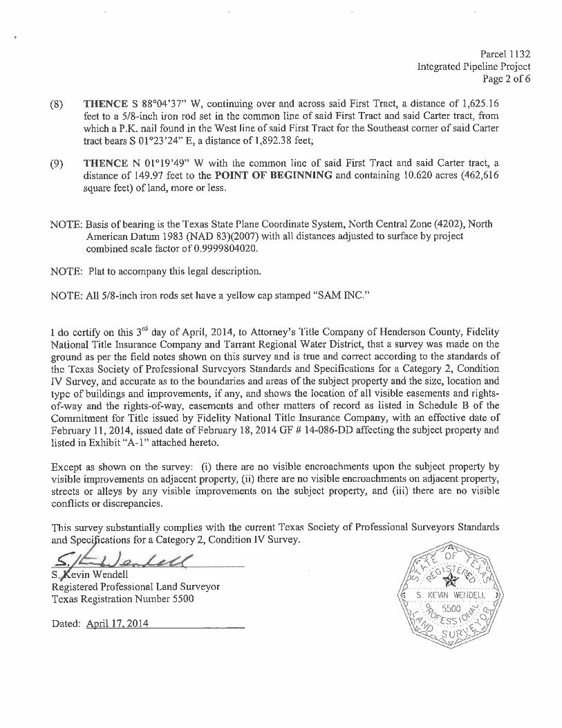
Parcel 1132Integrated Pipeline Project
Page 2 of 6
(8) THENCE S $$°04’37” W, continuing over and across said first Tract, a distance of 1,625.16feet to a 5/8-inch iron rod set in the common line of said First Tract and said Carter tract, fromwhich a P.K. nail found in the West line of said first Tract for the Southeast corner of said Cartertract bears S 01°23’24” E, a distance of 1,892.3$ feet;
(9) THENCE N 01°19’49” W with the common line of said First Tract and said Carter tract, adistance of 149.97 feet to the POINT OF BEGINNING and containing 10.620 acres (462,616square feet) of land, more or less.
NOTE: Basis of bearing is the Texas State Plane Coordinate System, North Central Zone (4202), NorthAmerican Datum 1983 (NAD 83)(2007) with all distances adjusted to surface by projectcombined scale factor of 0.9999804020.
NOTE: Plat to accompany this legal description.
NOTE: All 5/8-inch iron rods set have a yellow cap stamped “SAM iNC.”
1 do certify on this 3td day of April, 2014, to Attorney’s TitLe Company of Henderson County, fidelityNational Title Insurance Company and Tarrant Regional Water District, that a survey was made on theground as per the field notes shown on this survey and is true and correct according to the standards ofthe Texas Society of Professional Surveyors Standards and Specifications for a Category 2, ConditionIV Survey, and accurate as to the boundaries and areas of the subject property and the size, location andtype of buildings and improvements, if any, and shows the location of all visible easements and rights-of-way and the rights-of-way, easements and other matters of record as listed in Schedule B of theCommitment for Title issued by Fidelity National Title Insurance Company, with an effective date offebruary 11, 2014, issued date of February 18, 2014 GF # 14-086-DD affecting the subject property andlisted in Exhibit “A-i” attached hereto.
Except as shown on the survey: (1) there are no visible encroachments upon the subject property byvisible improvements on adjacent property, (ii) there are no visible encroachments on adjacent property,streets or alleys by any visible improvements on the subject property, and (iii) there are no visibleconflicts or discrepancies.
This survey substantially complies with the current Texas Society of Professional Surveyors Standardsand Speci ications for a Category 2, Condition IV Survey.
S.,Kevin WendellRegistered Professional lZand SurveyorTexas Registration Number 5500
OF\. .\‘Pi
‘‘ K-S KEi1 I
, 5t)(J -ì’
J -
Dated: April 17. 2014

PC PARCEL 722ALTON GARY
VOL 1056, PG 5790 RM.C,T.
THIkO TRACTP.O.R.
7%/2’IRr
EXHIBIT “A”
W. SIMS SURVEY PARCEL 1132
ABSTRACT 712
-.
.
600 300 0
GRARHIC SCALE IN FEET
-
600’
LU>
F.—
IRL PARCEL 722ALTON GARY
T.W. FRIZZELL SURVEYU) VOL 1056 PG 579
D.RJ-ICTN
a ABSTRACT 237 Z SECONDCI
aIPC PARCEL 722
a
ALTON GARYVOL 1056 PG 579
D.RI4C.Tb a FIRST tRACT
PARCEL 1132 a0.620 AC. 1
• — -
.E*_._.__
79 ‘
Z, N 33,578.11412,616 SQ.FT.a E: 2,807.358.331 46
N88’04’51”E 1,811 76’ F
_____
S88’04’37”W 1,625.16’
a
“®“1
IPL PARCEL 1119JASPER J. STEVENS AND WIFE,
EVELYN H STEVENSVOL. 275 PG. 49
D.R..C I.1ST TRACT
(SAVE & EXCEPT FM 1615 ROw)ANN GARY AND ALTON GARY
VOL 1253, PG 483DR.H.C.T.
FIRST TRACTCALLED 81.5 AC. TR.
0;a..I0;
cJ
IJwo;<00,5.
JzI
SEE
a..a
C”),0•’c0
Wa
C’,),
0’CR
NOTE 1
4SECOND TRACT
CALLED 7.5 AC. TR. H
P.O.R.P1< NAIL tOUND..,,\
A. PARKS SURVEYABSTRACT 607
LINE TABLE
s.iRVZY LINE ‘7
THIRD TRACTCALLED 44 AC. TR.
“‘ N. NUGENT SURVEYABSTRACT 981
SURVEY LINE
N. LOVEL SURVEYABSTRACT 448
P.O.B.P.O.R.
D.R.H.C.T.
LEGEND
POINT OF BEGINNINGPOINT OF REFERENCEDEED RECORDS.HENDERSON COUNTY, TEXAS
O.P.R.H.C.T. OFFICIAL PUBLIC RECORDSHENDERSON COUNTY, TEXAS
• = MARKER FOUND AS NOTEDO = 5/8 IRON ROD SET WITH
YELLOW CAP STAMPED “SAM INca
NO BEARING DISTANCELi S85.39*28aE 153.54’L2 S27’04’44”W 1 56.44’Li N7924’56”W 326.29kL4 N7920’16”W 562.65WL5 N8545’36”W 493.1 1’E N0119’49”W 149.97’
NOTE: LEGAL DESCRIPTION TO ACCOMPANY THIS PLAT.NOTE; NO KNOWN UTILITIES FOUND 2/18/2013.NOTE 1: LUCY J. VAUGHN SURVEY, ABSTRACT 788
7101 ENVOY COURTDALLAS. TEXAS 75247(214) 631-7888FAX: (216) 631-7103FIRM REGISTRATION No,
037177 TRWO TASK 17
SHEET TITLE
EXHIBIT “A”SEGMENT 19—2, PARCEL 1132
ANN GARY AND ALTON GARY
INTEGRATED PIPELINE PROJECT
BASIS OF BEARING IS THE TEXAS STATE PLANE COORDINATESYSTEM, NORTH CENTRAL ZONE (4202) NORTH AJ,IERICAN DATUM F(NAD83)t2007 WITH ALL DISTANCES ADJUSTED TO SURFACE BYPROJECT COMBINED SCALE FACTOR 0.9999804020

In addition, R. Steve Christian is granted authority to execute all documents
necessary to complete these transactions and to pay all reasonable and necessary
closing and related costs incurred with these acquisitions. Director Leonard seconded
the motion and the vote in favor was unanimous.
19.
There were no future agenda items approved.
20.
The next board meeting was scheduled for August 18, 2015.
21.
There being no further business before the Board of Directors, the meeting was
adjourned.
President Sectary