priority conservation areas and vision for biodiversity ... · priority conservation areas and...
TRANSCRIPT

LAKE MALAWI/NIASSA/NYASA ECOREGION CONSERVATION PROGRAMME
Priority Conservation Areas and Vision for Biodiversity Conservation
Comp
Jonas
Neil B
Michel
Steve
iled by:
Chafota,
urgess,
e Thieme
& Johnson
WWF SARPO
2005

Priority Conservation Areas and Vision for Buiduversity Conservation
TABLE OF CONTENTS Page Acknowledgements ……………………………………………………………………… iii
Summary ……………………………………………………………………….................. iv
List of Acronyms ………………………………………………………………………….. v 1. BACKGROUND …………………………………………………………………… 1 2. ECOREGIONAL PLANNING PROCESS .……………………………………….. 3 3. BIOLOGICAL VALUES …………………………………………………………… 4 3.1 Overview of the amphibians of the ecoregion ………………………………… 5 3.2 Overview of the reptiles of the ecoregion …………………………………….. 7 3.3 Overview of the birds of the ecoregion ……………………………………….. 7 3.4 Overview of the mammals of the ecoregion ………………………………….. 8 3.5 Overview of the invertebrates of the ecoregion ……………............................. 9 3.6 Overview of the macrophytes of the ecoregion ………………………………. 9 4. MAPPING THE CONSERVATION LANDSCAPE ………………………………. 10 5. IDENTIFICATION OF IMPORANT BIODIVERSITY AREAS ……………….… 11 6. THREATS TO THE LAKE ENVIRONMENT …………………………………... 17 7. OPPORTUNITIES FOR CONSERVATION AROUND THE LAKE …………….. 19 8. WHERE DO OPPORTUNITIES OUTWEIGH THREATS ……………………….. 19 9. FINAL PRIORITY CONSERVATION AREAS …………………………………… 24 10. PRIORITY CONSERVATION ACTIONS ……………………………………….... 27 11. WAY FORWARD ………………………………………………………………….. 28 12. REFERENCES ……………………………………………………………………… 28 Appendices Appendix IA Objectives Tree (Outline of log frame) …………………………… 31 Appendix IB Biodiversity conservation targets for Lake Malawi/Nyssa/ Niassa ecoregion ………………..……………………………….... 33 Appendix II Description of conservation priority areas ………………………... 38 Appendix III List of participants ....……………………………………………… 79 List of Tables Table 1: The riverine and lacustrine fishes of the Lake Malawi/Niassa/Nyssa system and the percentage endemicity. ………………………………………. 6
i

Priority Conservation Areas and Vision for Buiduversity Conservation
Table 2: Data layers produced by the different group work activities …………………. 14 Table 3: Scores used to make combined maps of threat and opportunity across the Lake
Malawi/Nyssa/Niassa ecoregion………………...…………………………….. 24 List of Figures Figure 1: The location of Malawi Niassa/Nyssa ………………………………………… 2 Figure 2: Diagrammatic representation of the ecoregion conservation process ………… 5 Figure 3: Map of Lake Malawi/Nyssa/Niassa ecoregion showing major rivers and Catchments ……………………………………………………………………. 13 Figure 4: Zones and localities of high fish biodiversity and endemism on Lake Malawi/Nyssa/Niassa ecoregion ……………………………………………… 15 Figure 5: Distribution of wetland associated species and localities of importance for each species on lake Malawi/Nyassa/Niassa ecoregion ………………….. 16 Figure 6: Combined priority areas for fish and wetland associated animals for the Freshwater systems of Lake Malawi/Nyassa/Niassa ecoregion ………………. 18 Figure 7: Map of Lake Malawi/Nyassa/Niassa ecoregion showing major sources of water inflow, sediments and nutrients. ……………………………………. 20 Figure 8: Distribution and types of threats from land based human activities on the
catchment areas of lake Malawi/Nyassa/Niassa ecoregion …………………… 21 Figure 9: Major areas of existing ad potential biodiversity conservation on Lake Malawi/Nyassa/Niassa ecoregion ……………………………………………. 22 Figure 10: Distribution and location of different types of inshore fisheries on Lake Malawi/Nyssa/Niassa and on the rivers ………………………………………. 23 Figure 11: Combined threats and conservation opportunities on Lake Malawi/ Nyssa/Niassa ecoregion ……………………………………………………….. 25 Figure 12: Final priority areas for biodiversity conservation in the Lake Malawi/ Nyssa/Niassa ecoregion ……………………………………………………….. 26
ii

Priority Conservation Areas and Vision for Buiduversity Conservation
ACKNOWLEDGEMENTS We would like to acknowledge the continued support provided by the riparian states governments: Malawi, Mozambique and Tanzania in all stages of the development of the Lake Malawi-Niassa-Nyssa Ecoregion Programme. A special word of thanks goes to all the individuals who contributed to the production of background papers presented and discussed at the workshop and these include Dr. David Cumming, Dr. Moses Banda, Lucy Scott, Tie ga Anada, Denis Landenburgue, Alex Bulirani and Brian Rashid. We would also like to thank all the participants who participated in the group work and plenary discussions. The workshop was framed around the technical expertise of WWF-US’s capable team comprising of Kate Newman, Neil Burgess, Tom Allnutt who guided the process and produced a range of GIS maps, often working through the night to meet workshop deadlines. For their dedication and commitment, we owe them a great debt of gratitude. Steve Johnson is also thanked for his professional facilitation in steering the workshop to meet its objectives. Dr. Moses Banda (Malawi), Dr. Ben Ngatunga (Tanzania) and Jose Halafo (Mozambique) made a valuable contribution in describing the priority conservation areas for their respective countries. Dr. Ribbink and his team provided information on the overview of the biodiversity resources of the lake. Finally, this workshop could not have been possible without funds provided by WWF-US.
iii

Priority Conservation Areas and Vision for Biodiversity Conservation
Summary Lake Malawi-Niassa-Nyssa is a large, long and narrow freshwater lake in southern Africa covering the territories of Tanzania, Malawi and Mozambique. It is the southernmost of the Western Rift Valley lakes located between 9o 30’ – 14o 40’S, 33o50’ – 33o36’E. The lake is the ninth largest in the world, the fourth deepest, and has a surface area of 31,000 km2. The lake depression consists of a series of grabens and half grabens, and this pattern of rift faulting results in the boundary of the lake varying from extensive plains, particularly in the south, to steep-sided mountains in the north. The lake’s catchment covers about 130,000 km2 and includes much of Malawi, the south-western corner of Tanzania and the north-western corner of Mozambique. Lake Malawi was formed millions of years ago as a part of the development of the Great Rift Valley system of Africa. It is termed an ‘ancient’ lake in global terms, and has a high biological importance. Internationally, the main significance of Lake Malawi-Niassa-Nyssa is in terms of it values for the conservation of species narrowly restricted to that lake. Lake Malawi is home to 15% of the world’s freshwater fish species, with more than 600 endemic species in total. The lake also lies within flyways of migratory birds that use the lake margins for feeding on their way between Africa and Europe. These biological values are the primary reason why WWF as a conservation organisation is interested in the management of the lake. At the national level the major importance of the lake is in terms of its fisheries productivity and to a lesser extent as a destination for tourists. Important facts about the fisheries are that the lake is the source of 50-60% of the total animal protein supply in Malawi; over 70% of Malawi’s population relies on Lake Malawi and its catchment for their daily survival needs and livelihoods; a total of 95% of all electricity in Malawi is generated from the outflow of Lake Malawi; and the lake is the venue for 60-70% of domestic and international eco-tourism in Malawi. There are a number of environmental concerns affecting the lake. Most important of these is that soil erosion is above the acceptable level of 12 tonnes per hectare per year (t/ha/yr) within all of the catchments that drain into the lake. This means that over the long term the composition and quality of the lake’s waters are likely to change, resulting in a reduction of fish biodiversity and a decline in the fisheries productivity. In addition to the high rates of erosion, overfishing has caused fish stocks to decline by 10,000 tons per year (t/yr) and per capita fish consumption is 50% of what it was 20 years ago. Further problems come from the fact that most people living around the lake are very poor. Thus, they have few, if any, alternatives to farming in ways that cause high levels of erosion or fishing at high rates of exploitation. Finally, the countries surrounding the lake, especially Malawi, have some of the highest rates of HIV/AIDS in the world, which have caused high rates of morbidity and mortality among professional staff that have lowered the outreach capacity of government and non-government organizations (NGOs) alike. Each of the three riparian states manages its portion of the lake according to national policies and strategies. Due to the shared nature of the resource, it is essential that some form of collaborative management of this common resource is developed.
iv
Priority Conservation Areas and Vision for Biodiversity Conservation
ACRONYMNS a.s.l. Above Sea Level ACORD Agency for Co-operation in Research and Development ADB African Development Bank BVCs Beach Village Committee CBD Convention on Biological Diversity CBNRM Community Based Natural Resources Management CBOs Community Based Organizations CIDA Canadian International Development Agency CITES Convention in International trade in Endangered Species of Wild Fauna
and Flora DANIDA Danish International Development Agency EIA Environmental Impact Assessment ELDP Evangelical Lutheran Development Programme FAO Food Agriculture Organisation GEF Global Environmental Facility GIS Geographic Information Systems HIV/AIDS Human Immunodeficiency Virus/Acquired Immunity Deficiency ID Identity IUCN International Union for the Conservation of Nature LMNN-ER Lake Malawi/Niassa/Nyssa Ecoregion MAFRI Malawi Fisheries Research Institute MASAF Malawi Social Action Fund MNN Malawi-Niassa-Nyssa NEAP National Environmental Action Plan NGO Non Governmental Organisations NORAD Norwegian Development Agency ODA Oversees Development Agency RAMSAR Convention on Wetlands SADC Southern Africa Development Community SEA South East Arm TAFIRI Tanzania Fisheries Research Institute UK United Kingdom UNDP United Nations Development Programme UNESCO United Nations Educational Scientific Organisation UNIMA University of Malawi VNRMC Village Natural Resources Management Committee WB World Bank WESM Wildlife and Environmental Society of Malawi WHO World Health Organisation WSM Wildlife Society of Malawi WWF World Wide Fund for Nature WWF-SARPO World Wide Fund for Nature – Southern Africa Region Programme
Office
v
Priority Conservation Areas and Vision for Biodiversity Conservation
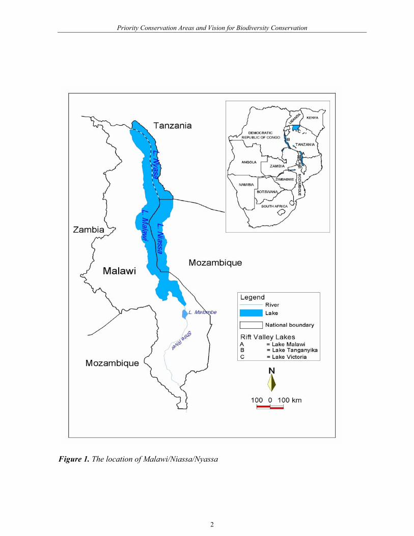
1. BACKGROUND World Wildlife Fund has adopted ecoregions as a strategic global conservation approach. Ecoregions are relatively large units of land or water, which are biologically distinct from their neighbours and that harbour characteristic sets of species communities, dynamics and environmental conditions. The Conservation Science Program of WWF-US has undertaken the task of defining terrestrial, freshwater and marine ecoregions of the world (Olson et al., 2001; Abell et al., in prep). An analysis of these ecoregions has resulted in the identification of a set of global conservation priorities in the terrestrial, freshwater, and marine realms. The priority ecoregions have been named the ‘Global-200’ ecoregions by WWF and they form one of the targets for conservation investment by the WWF network (Olson and Dinerstein, 1998). In Africa the most biologically outstanding freshwater Global-200 ecoregion (actually a collection of three smaller ecoregions) is the Rift Valley Lakes, comprising Lake Victoria, Lake Tanganyika and Lake Malawi/Niassa/Nyssa. The Rift Valley Lakes Global-200 Ecoregion has been assessed at the highest level of global biological importance, a fact which has also been recognised in other conservation assessments (e.g., Ribbink, 2000; Groombridge and Jenkins, 1998). Hence, the Rift Valley Lakes are a clear target for conservation investment by WWF and other conservation bodies. Lake Malawi-Niassa-Nyssa is the most biologically valuable lake in the Rift Valley Lakes Ecoregion, and is widely regarded as the most biologically important lake in the world. It is particularly important for its concentrations of endemic fish species and especially its cichlid species radiation. More than 600 and perhaps as many as 1000 fishes are endemic to the lake and the majority belong to one monophyletic species flock of cichlids (Myer, 1993; Ribbink, 2000; 2001a). At the higher estimations, this would mean that this lake of about 29,000 km2 holds more freshwater fish species than all of the freshwaters of North America and Canada combined (790 species described) (Page and Burr, 1991; Ribbink, 2000). The lake basin and its biodiversity are the products of millions of years of evolution. During that time a huge array of complex, interrelated physical and biological processes developed to sustain the system and its diversity. The species in the lake, especially the endemic fish are vulnerable to habitat change as they are specialists with small populations and a narrow distributional range. Lake Malawi-Niassa-Nyassa is shared between Malawi, Tanzania, and Mozambique (Figure 1). The Lake Malawi/Niassa/Nyassa ecoregion extends beyond the lake to encompass its drainage basin plus Lake Malombe to the south. The lake and ecoregion cover about 130,000 km2 and include much of Malawi, the south-western corner of Tanzania and the north western corner of Mozambique. Each of the three riparian states manages its own portion of the lake according to national policies and strategies. Increasing threats to the biodiversity in the lake from over-fishing and siltation resulting from land use dynamics and socio-economic processes in the surrounding catchments indicate that it is essential that some form of collaborative management of this common resource is developed as a matter of urgency.
1
Priority Conservation Areas and Vision for Biodiversity Conservation
Figure 1. The location of Malawi/Niassa/Nyassa
2

Priority Conservation Areas and Vision for Biodiversity Conservation
Millions of people from the three riparian states are dependent on the lake and its river systems for their livelihoods. The lake system provides fishery resources, water for domestic use, livestock, agriculture, hydropower generation and also provides opportunities for transport and tourism development. The fisheries of Lake Malawi-Niassa-Nyassa can be broadly divided into three primary categories: mechanised commercial, small scale (artisanal) and ornamental fisheries. As the case with most developing country fisheries, the small-scale sector predominates. The artisanal fisheries are open access and operate around the lake in the in-shore areas. Gill nets, hooks and lines, traps, seines (open water seines: chirimila and nkacha and beach seines: kambuzi and chambo) and scoop nets/ dip nets have been the main gears used. The artisanal fisheries contribute over 90% of the estimated total annual landings from the lake (35,000-55,000) tonnes and accounts for all landings (100%) in Tanzania (3000-5000 tonnes) and Mozambique (7,000-10,000 tonnes) and about 80% of the landings in Malawi (25,000-40,000). The mechanised commercial fisheries are capital intensive and use mainly trawling and purse seining (‘ring net’). The commercial vessels account for about 6,000 tonnes and are confined to the southern part of the lake. The ornamental fishery principally targets the live colour, attractive rock dwelling cichlids for the export market. Currently, there are five companies engaged in the aquarium fish trade, two based in Malawi and three in Tanzania. The operations of all but one are erratic. The total volume of export is not known but perhaps it is more than 70,000 individuals annually. The statistics from the Malawi sector indicate that about 50,000 individuals are exported annually. There is presently inadequate information on the value of the exported fishes from Lake Malawi-Niassa-Nyassa. Collection of live fish is carried out along the rocky shores of the lake and around the islands. Because of its exceptional regional and global biological importance, and emerging evidence of increasing threats to the biodiversity WWF has been working in the area since 1998. The main focus of this work has been to consult with the governments and local organisations, in order to identify threats to the lake and conservation opportunities, to develop a regional conservation plan and to reach an agreement on the collaborative mechanism to implement such a plan. This vision document aims to identify focal areas for conservation of the lake’s biodiversity and to determine and address the socio-economic factors that provide threats and opportunities for the conservation of the area in the long term. 2. ECOREGIONAL PLANNING PROCESS The WWF Ecoregion planning process aims to develop a long-term plan for the conservation of the most important areas for biodiversity conservation on the planet. The process involves a number of different stages, leading to implementation of conservation actions to improve the conservation situation on the ground in the ecoregion. The ecoregion conservation process is guided by the following principles: - a focus on biodiversity conservation; - the development of a clear long-term biodiversity vision; - implementation of a multidisciplinary approach; - the participation of all stakeholders and experts; - the formation of partnerships; - an adaptive management approach (i.e., learning and refining process as it develops); and - the recognition of the complexity and inherent political nature of conservation.
3

Priority Conservation Areas and Vision for Biodiversity Conservation
The different stages in the process are as follows (see Figure 2): - Reconnaissance Phase. The aim of this stage is to collect background information on the area and to start to develop relationships with important stakeholders who will be involved with later stages and in the implementation of the results of the work. The reconnaissance phase includes biological as well as socio-economic assessments. The focus of the biological assessment is to record the distribution of species and communities, and to register the ecological dynamics and processes in given landscapes that sustain species. The socio-economic assessment takes note of the current interactions and situations in an effort to determine future pressures and opportunities inside and outside the ecoregion. - Biodiversity Vision Stage. The aim of this stage is to develop a biodiversity vision for the ecoregion that can be used over the longer term. This stage also defines in more detail the biological values of the ecoregion and starts to assess the conservation actions that need to be taken to conserve these values in the longer term. - Situation Analysis. This stage involves a multi-disciplinary analysis of threats, opportunities, tradeoffs, and options. - Ecoregion Strategy and Action Plan. This part of the process develops the conservation targets and actions required to ensure the conservation of the biological values identified in the vision stage. These targets and actions can be worked into the format of project proposals and hence used to raise funds for implementation. At this stage the mechanisms for coordinating and managing the agreed work need to be defined and the work begun. - Implementation. The results of the strategy and action plan are implemented as a partnership between WWF and other stakeholders who have been involved in the planning process. Fundraising for implementation will inevitably form a major part of the work at this stage. 3. BIOLOGICAL VALUES The most outstanding biological feature of Lake Malawi/Niassa/Nyasa is the presence of large number of endemic fish species, with the lake having the highest number of endemics of any of the Rift Valley Lakes. Although fourteen families of fish are represented in the lake’s catchment (Table 3), the family Cichlidae dominates in terms of species richness. Formal scientific description and naming of many cichlids remains to be completed as professional systematists cannot keep pace with the rate at which new species are being discovered. It is certain that further new species of fish will be discovered as research continues. Lake Malawi also supports populations of mammals, birds, amphibians, reptiles and plants. None of these groups contain high rates of endemism in the lake, although there are also some endemic aquatic invertebrates.
4

Priority Conservation Areas and Vision for Biodiversity Conservation
Reconnaissance
Multi - disciplinary and rapid assessment of conservation needs and opportunities and key data gaps
Biological Assessment Socio-Economic Assessment
Biodiversity Vision Long - term vision for the ecoregions biodiversity
Situation Analysis Multi-disciplinary analysis of threats, opportunities, tradeoffs and options
Ecoregional Conservation Plan Conservation vision, goals, and the actions needed to achieve those goals, including protected areas, sustainable development, education and capacity building, and policy reform etc.
WWF Action Programme
International Donors Actions
National Government Actions
Local Government and Local Peoples Actions
Actions: - Projects - Coordination - Data provision - Policy reform - Etc
Monitoring and Evaluation: - Measure progress towards goals - Measure progress towards
objectives and outputs - Measure achievement of activities
Root Cause Analysis Examines the underlying causes of resource degradation
Figure 2. Diagrammatic representation of the ecoregion conservation process 3.1 Overview of the amphibians of the ecoregion Worldwide, Amphibia are in decline, usually as a consequence of habitat degradation or loss, but often for reasons that are not apparent. It is particularly perplexing that amphibians are disappearing from remote areas, untouched by humans (Blaustein & Wake 1990). The same could be occurring in the Lake Malawi/Niassa/Nyassa ecoregion, but too little is known about the Amphibia of the ecoregion to be able to detect such changes, or even species extinctions. A more thorough assessment of the Amphibia is necessary so that at least a baseline can be established.
5

Priority Conservation Areas and Vision for Biodiversity Conservation
Table 1. The riverine and lacustrine fishes of the Lake Malawi/Niassa/Nyassa system, and the percentage endemicity. Endemicity is lower in rivers than in the lake. All families in the lake also have riverine representatives, but not all riverine families have representatives in the lake (Data from the systematics team of the SADC/GEF Lake Malawi Biodiversity Project). R =present in rivers; L = present in lake.
Family Genera Species Endemic % 1. Protopteridae R 1 1 0 2. Anguillidae R&L 1 1 0 3. Mormyridae R&L 4 7 0 4. Salmonidae R 1 1 0 5. Characidae R&L 2 2 0 6. Cyprinidae R&L 5 26 38 7. Bagridae R&L 2 4 25 8. Amphilidae R 1 2 0 9. Clariidae R&L 2 17 71 10. Mochokidae R&L 2 3 33.3 11. Poeciliidae R&L 1 1 0 12. Aplocheilidae R 1 2 50 13. Mastacembelidae R&L 1 2 100 14. Cichlidae R&L TOTAL ENDEMICS
41
c. 750 c.768 species
99.5
Poynton & Broadley (1991) recognised 10 families, 25 genera and 101 species (including two undescribed species) of the Order Anura from the region. Their focus was almost exclusively in Malawi (where 80 species were found) and Mozambique (69 species). There are currently 51 species that are found in both Mozambique and Malawi. Eighteen species are found only in the Malawi/Mozambique surveys and not in surrounding countries, suggesting an endemicity of 23%. However, as the area within and beyond the ecoregion has been poorly surveyed, it is difficult to accurately assess the true degree of endemism. The number of species occurring in the basin on the Tanzanian side is uncertain at present. Those species occurring in the north-eastern parts of Tanzania, and also in Malawi and/or Mozambique are recorded on the assumption that they may be found in the intervening areas of the eastern side of the ecoregion (i.e. in the Tanzanian provinces within the lake basin). The review by Poynton & Broadley (1991) forms a useful baseline for comparison, and shows unambiguously the need for surveys of Amphibia, especially in the eastern part of the lake basin. The Order Apoda is represented by two species in the Family Caecilidae. There are no recorded species of Caudata (salamanders and newts) in the region. The conservation status of amphibian species of the region cannot be determined with any precision due to lack of adequate surveys and an inventory. It may be assumed that those species/sub-species thought to be endemic are likely to be under the most immediate threat (Ribbink 2001a). Little more is known about the amphibians of the ecoregion than has been described by Ribbink (2001a) in the reconnaissance report, and the need for biodiversity surveys was reiterated, especially along the Tanzanian and Mozambican coastlines.
6

Priority Conservation Areas and Vision for Biodiversity Conservation
3.2 Overview of the reptiles of the ecoregion Reptilia include the crocodile, lizards, skinks, snakes, turtles, tortoises and terrapins. Of these the crocodile, monitor lizard, terrapin and turtles are most closely associated with the freshwater habitats. Lake Malawi/Niassa/Nyssa does not have a truly amphibious snake, but many snakes do take to the water and swim, sometimes quite considerable distances. These swimmers include the python, mambas, cobras, and puff-adders. All told, 139 species of reptile are recorded from the region with most information being available from Malawi. The 139 species are representative of 22 families indicating that the phylogenetic diversity is considerable (Ribbink 2001a). Thirteen species are considered to be endemic to the region. The geographic range of endemicity is uncertain for most species, and must be extended by further surveys that enable distribution to be plotted more accurately. Very little is known about the conservation status of any of the reptiles either, and a priority activity should be an extension of the knowledge base for reptile biodiversity. In the interim, all endemic species should be treated as under conservation threat. In the State of the Environment Report for Malawi, Munthali (1998) reports that crocodile populations are in decline, mainly due to conflicts with people who use the same habitats. In addition to the crocodile, Munthali (1998) lists the following as threatened: Chamaeleo muelleri, Chamaeleo mlanjensis, Rhampholeon elatyceps, Platysaurus mitchelli, and Lygodactylus rex. However, distribution records suggest that several of these species may not be present in the ecoregion. No threatened reptile species are recorded from the eastern catchment of the lake. This may reflect a lack of study. Hopefully, the low human population density and lack of development there also means that reptile populations, including undiscovered ones, are intact (Ribbink 2001a). The paucity of knowledge of the reptiles and the need for biodiversity surveys is important. 3.3 Overview of the birds of the ecoregion Records for the eastern shores are poor and reliance has been placed on those obtained from Malawi. Benson & Benson (1977), and Newman, et al. (1992) give the bird count for Malawi at precisely 620 species. The most recent checklist (Dowsett-Lemaire and Dowsett, in press; from Duthie pers. comm.) gives 648 species from 78 families, comprising 456 residents, 94 intra-African migrants of regular occurrence, most of which probably breed in Malawi, and 77 regular and 12 vagrant Palaearctic species. As much of the ecoregion is in Malawi, and as many habitats are represented in Malawi, the tally of birds for the ecoregion is probably an underestimate, but not seriously so. It appears as though a checklist of birds for the Tanzanian and Mozambique catchments does not exist. Only the early studies of Vincent (1933, 1934, 1935, 1936) specifically cover birds north of the Zambezi (Ribbink 2001a). Over one third of all bird species in Malawi are considered to be uncommon or rare, and of long-term conservation concern (Newman et al. 1992), although for many of these species, little is known of their exact population status. As with the fishes, naturally rare species may not necessarily be threatened unless activities such as harvesting are making inroads into their population size. The species richness of the birds is only slightly lower than that of the fishes of the region. However, the fishes are represented by only 14 families, whereas 78 families represent the birds, indicating a broader diversity of birds at the higher taxonomic level. This comparison emphasises the dominance of the family Cichlidae, with its large species-flocks, in its contribution to species richness of fishes. Ninety-four birds in Malawi are restricted-range species, found in only one or a few biomes as used by the Endemic Bird Areas project of Birdlife International (Stattersfield et al. 1998). Nine species of bird that are listed in the
7
Priority Conservation Areas and Vision for Biodiversity Conservation
1996 Red List of Threatened Animals are known to occur in Malawi. However, many of the biome-restricted and endemic birds that are area-restricted may be considered to be under conservation threat since their distribution is now restricted to a small number of sites, and habitat degradation is leading to diminution of their habitat patches. Those species whose main distribution lies outside of existing large protected areas may be especially vulnerable to local extinction in the short term. Newman et al. (1992) show that a high proportion of the birds have strong affinities for aquatic habitats. Many of the birds associated with water are valuable ecological components and are attractive to ornithologists (Ribbink 2001a). During the team discussion, the paucity of knowledge of the birds and the need for biodiversity surveys was confirmed. No further qualifying information could be added to Ribbink’s 2001a reconnaissance report. 3.4 Overview of the mammals of the ecoregion It is not certain how many mammal species are to be found in the lake basin as the surveys on the eastern catchments are sparse and records are not easily found. The mammals of Mozambique were last reviewed by Smithers & Tello (1976), but little attention was paid to the regions of the Niassa Province that comprise the lake basin. In Mozambique, there are records for the Niassa Reserve (only 63 species are listed, which is probably the larger mammals only, of which three are on the verge of extinction), but no overview of mammal richness or diversity for the lake catchment is available. The best guide for the region stems from Malawi (Ansell & Dowsett 1988), where the most recent list of mammal species recorded for the country as a whole comprises 188 species from 37 families. This total excludes species of domestic mammals (livestock, equines and pets). Several of the mammals recorded on the list might not occur in the lake basin, these will be removed from the list for the ecoregion when their precise distribution is known. None of the mammals recorded in the lake basin is endemic to the ecoregion (Ribbink 2001a). Information on the conservation status of the mammals of Tanzania and Mozambique within the basin was not found. For Malawi, the State of the Environment Report on Biodiversity (Munthali 1998) indicates that all large mammals are in decline, and that the Black Rhinoceros is extinct (though three have been reintroduced), the Cape Hunting Dog is rare. Seven species of mammal listed in the 1996 IUCN Red List of Threatened Animals (Baillie and Groombridge 1996) occur in Malawi and are thus of special conservation concern. The 1994 National Environmental Action Plan (NEAP) (Government of Malawi 1994) lists five of these species as threatened in Malawi, along with six additional species: Blue monkey, Waterbuck, Puku, Sable, Suni, and Nyala, which are also considered to be threatened. Lion and the squirrel, Paraxerus palliatus, were not listed as endangered in Malawi in the 1994 NEAP, but are in serious decline. Duthie (pers. comm.) argues that trends indicate that mammals of 5 kg or more in Malawi are under considerable pressure from expansion of human activities and commensurate loss of habitat and that, outside of protected areas, there is little prospect for the long-term survival of any species. Smaller mammals (less than 5 kg) may persist even outside of protected areas, so long as patches of natural and semi-natural habitat remain as part of the landscape mosaic (Ribbink 2001a). The hippopotami and otters are probably the only mammals that have a true affinity for and dependence on water. Hippopotami are in decline in the ecoregion and if present trends continue they will be lost to the lake and its immediate environs. Fortunately, hippopotami are protected in the Liwonde National Park. A small population can be retained there and in the Lower Shire River, but it will be sad to lose these large mammals from the ecoregion. The conservation status of otters
8
Priority Conservation Areas and Vision for Biodiversity Conservation
is unknown, but it is clear that they are not common anywhere (Ribbink 2001a). There is therefore a need for biodiversity survey focussing on mammals. 3.5 Overview of the invertebrates of the ecoregion The precise number of invertebrate species in lake basin is not known. The total invertebrate species richness might be well in excess of the 8,000 species, including more than 7,000 insect species. The proportion of this estimated number, which spends all, or part of their life in water is uncertain (Ribbink 2001a). The invertebrates of the ecoregion, the two lakes and the rivers in particular, are extremely important components of the ecosystem being essential to many of the ecological and evolutionary processes. Most invertebrates are very poorly studied. Abdallah (2000) found a total of 78 taxa in the benthic “macroinvertebrate” community on the rocky shores of the southern part of the lake. The community was dominated by ostracods (50% of total density); water mites (Hydracarina) (21% of total density); chironomids (13% of total density and 60% of all insect larvae); and copepods, that together make up two-thirds of the total number of invertebrates recorded. This result agrees with the previous findings reported by Fryer (1959) from Nkhata Bay in the central part of the lake. In comparison with temperate lakes and other lakes in Africa, Abdallah found that the numerical abundance of invertebrates in Lake Malawi/Niassa/Nyssa is very low. He found that the distribution of the invertebrates was affected by depth, structural habitat, wave action and seasonality. His data would support analyses of alpha and beta diversity, showing strong distributional gradients in as little as five metres depth. All invertebrates except the molluscs decreased in abundance with depth (Abdallah pers. comm.). Molluscs are well represented in the basin with 172 species being recorded of which 47 species (27%) are endemic. Eight species are listed by IUCN as either Vulnerable (Bulinus nyassanus (Planorbidae); or Endangered [Bulinus succinoides (Planorbidae); Lanistes nasutus, L. nyssanus; L. solidus (Ampullaridae); and Bellamya ecclesi; B. jeffreysi; B. robertsoni (Viviparidae)]. However, the source of the data that led to the listing and the criteria used are unclear and need to be questioned, as some of these species do not seem to be endangered. For example, L. nyassanus is common and should therefore not be listed (Ribbink 2001a). 3.6 Overview of the macrophytes of the ecoregion Submerged macrophytes The distribution of these vegetated areas around the lake is unknown, but they are particularly vulnerable to being removed by seine netting. In addition, the vegetated areas are threatened by lakeshore settlements, notably the development of hotel and holiday resorts, which results in clearing of macrophytes on the fringes of the lake in order to create beaches. The habitat provides physical, structural and biological habitat for invertebrates, a large surface area for epiphytes, nursery grounds and refuges for fishes, as well as detritus. It is clear from the number of fishes (and perhaps other organisms too) that show close anatomical, behavioural and ecological adaptations to these vegetated areas that they represent the products of a long co-evolutionary association. The evolutionary association also reflects tight ecological interrelationships, suggesting that the vegetated areas represent a complex, but dynamic web of intricate activities. However, the ecological role and value of submerged macrophytes in the lake seems not to have been studied (Ribbink 2001a). The importance of submerged macrophytes was considered extremely high by all authors during the discussion
9

Priority Conservation Areas and Vision for Biodiversity Conservation
of aquatic habitats, even though quantitative information is lacking. The need for biodiversity surveys in vegetated regions was seen as a priority.
Emergent and floating macrophytes Fully documented analyses of the distribution, ecology and diversity of these plants along the fringes of the lake and the rivers that enter and leave the system have not been found. Nevertheless, the following picture does emerge. These plants are always in shallow fringe areas, along the lakeshore, in associated waters including rivers and swamps. They include the Phragmites mauritianus and Phragmites australis (reeds), Typha domingensis (bulrush), Cyperus papyrus (papyrus) and Vossia cuspidata (hippo-grass) stands. A characteristic of most aquatic plants is that they are able to grow and propagate very rapidly in the correct environment. In the case of the rooted emergent macrophytes (reeds, bulrushes, papyrus and hippo-grass) this rapid development and propagation results in dense, monospecific stands where conditions suit them. Within the centre of such stands no other macrophytic plants have an opportunity to succeed, but in the peripheral areas of these stands, habitats that suit other plants develop and mixed plant communities are found. Therefore the relationships of these rooted emergent macrophytes to other plants and to the physical environment can be instructive with respect to understanding biodiversity. A number of aquatic plant species are of conservation interest because of the threat they pose to natural ecosystems and species. Amongst the most significant to the aquatic environment are: Azolla nilotica (Azollaceae); Eichornia crassipes (Pontederiaceae); Myriophyllum aquaticaum (Haloragidaceae); Salvinia molesta (Salviniaceae) and Pistia stratiotes (Araceae) (Ribbink 2001a). It should be noted that species succession of vegetation in swamps and floodplains depends on seasonal inundation. In addition, anthropogenic influence on vegetation in these areas is enormous due to seasonal cultivation during low water level, especially evident along the shores of Lake Malombe and the Linthipe River. It is important that the impact of seasonal variation in water level and cultivation on emergent macrophytes is assessed. Algae The filamentous algae mat harbours a rich diversity of benthic fauna, including insect larvae, crustaceans (ostracods, copepods, and Caradina), and a myriad of other small invertebrates (Abdallah 2000). Nowadays it is recognised that the filamentous algae comprises at least 50 species, but their taxonomy is very poorly understood, as is their ecology. These certainly warrant a thorough assessment. The algal mat forms the mainstay of the communities of rocky habitats, being largely responsible for supporting the rich diversity of rock frequenting fishes. Trophic adaptations of fishes support a variety of feeding behaviours to utilise the algae. Some species pluck, mow or cut the filamentous species from the rock, ingesting and digesting it. Others (e.g. members of the genus Labeotropheus) ingest it, but do not digest it. These fishes collect the filamentous algae simply to obtain and digest the animals and unicellular algae that live among the filaments or grow on the filaments. Other fishes also feed on the epiphytes, but have numerous long-flexible teeth that are adapted to comb or brush them from the filaments (e.g. members of the genus Petrotilapia and the Pseudotropheus zebra species complex) (Ribbink 2001a). 4. MAPPING THE CONSERVATION LANDSCAPE Background information on the biological components of Lake Malawi was derived from the biophysical reconnaissance report (Ribbink, 2001a). Background information on socio-
10

Priority Conservation Areas and Vision for Biodiversity Conservation
economic processes was derived from the socio-economic reconnaissance report (Booth, 2000), updated using the compiled national stakeholder consultation reports (Johnson and Chafota, 2002). Technical working sessions at the October 2001 workshop involved group work activities designed to link biological and socio-economic factors to the long-term biodiversity vision and to define conservation targets and elements of the conservation strategy. The working session process involved the following basic steps: • Representation analysis: a spatial analysis of important biological and ecological
features as well as key socio-economic factors affecting biodiversity, was used to graphically represent important areas or elements for review.
• Amalgamation of important biological areas: the identification of areas where
known priority taxonomic and ecological-process layers overlap, in order to define important areas for biodiversity.
• Assessing socio-economic dynamics and factors: mapping of socio-economic
opportunities and threats across the Lake and the surrounding catchment, in order to produce better conservation recommendations
The participants at the workshop used the background information provided and added the collective expertise to refine our understanding of the biological and socio-economic issues for the lake and its catchments (Figure 3). A number of working groups were used to capture the assembled knowledge. A number of working groups were used to gather the data required to achieve these goals, as follows: a. Fish biodiversity b. Mammals, reptiles, amphibians and water birds c. Invertebrates and molluscs d. Limnology, hydrological processes, algae and vascular plants e. Socio economic processes The different working groups produced data which was transcribed into digital layers for GIS purposes, the components of which are shown in Table 2 and fully described in the following sections. These layers were developed and overlayed with each other in various configurations to provide composite perspectives for analysis. Each group was provided with specific guidelines for scoring the socio-economic, biological and ecological process parameters. 5. IDENTIICATION OF IMPORTANT BIODIVERSITY AREAS The biological working groups (see above) identified key biological areas in the Lake, drawing these onto large-scale paper maps and later, digitising it into a GIS system, capturing the information on these maps.
11

Priority Conservation Areas and Vision for Biodiversity Conservation
Fish biodiversity group This group concluded that the available data on the distribution of fish species in the lake was insufficient to allow the mapping of species distributions as a means of identifying those areas with the highest species richness or endemism. As a consequence, habitat types known to possess the highest fish endemism were used as a proxy to determine the most important zones in the lake for fish biodiversity. These habitat types were:
▪ the rocky islands jutting from the lake which are known centres of fish endemism; ▪ those river mouths of greatest importance for migratory (spawning) fishes; and ▪ those areas of the lake with water less than 50 m depth (considered to be the ‘shallow’
water) which have high rates of species turnover and endemism. More precise assessments of the most important areas for fish biodiversity could have been delineated if data on underwater substrate type had been available, rather than the current situation where substrate is only known for the coastal strip (Cooley, 2000). This is because the greatest concentration of endemic fish are known from rocky areas, followed by areas with underwater vegetation, and finally by areas with sandy or muddy substrate. This level of data was not available for inclusion in the working groups’ analysis. If a better ‘map of habitats’ were available which located these regions more precisely, they could be used to map out the likely areas of importance for the lake fishes. The deeper water pelagic fishery was regarded as important for the maintenance of the food productivity of the lake. However, this zone was not regarded as critically important for the conservation of biodiversity because the species found in the pelagic fisheries are largely common across the entire lake. Species associated with wetland habitats around the lake were also identified and mapped as a separate category. All the information on important habitats for the endemic fish was mapped and then digitised into ArcView GIS (Figure 4). These data layers were then made available for individual map production, or analysis in combination with other layers of data. Various layers of these maps were superimposed upon each other in ArcView and projected onto a large theatre cinema screen using a LCD-data projector. In this format it was possible to have all the participants of the workshop comment on the composite map, and refine the boundaries or add further data. This technique allowed the maps to be quickly and accurately modified and projected for successive sessions of analysis and critique. Other aquatic and wetland associated biodiversity
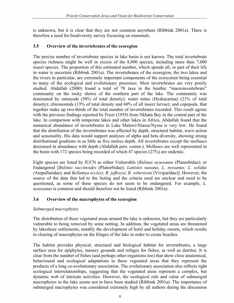
Mapping the centres of distribution for species of wetland associated biodiversity indicates areas or zones of the greatest importance for these species (Figure5). The most important regions are along the coastal strip of Mozambique and in southern Malawi.
12

Priority Conservation Areas and Vision for Biodiversity Conservation
Figure 3. Map of Lake Malawi/Nyasa/Niassa Ecoregion showing major rivers and
catchments.
13

Priority Conservation Areas and Vision for Biodiversity Conservation
Table 2: Data layers produced by the different group work activities
Description Data Layers Components Figure Biological Fish 4 Sensitive river mouth Islands 0-50 m depth contour Animal 5 Amphibians Benthos Cane rats Crocodiles Elephant Hippo Monitor lizards Otters Water birds Water buck Fish and Animal 6 Liminological/Process Process 7 Excess nutrient inflow Excess sediment inflow Excess water inflow Socio-economic Threat 8 Fire areas Tobacco areas Subsistence areas Deforestation areas Mining areas Opportunity 9 Existing bottom trawling Bottom trawling – opportunity Protected areas Potential protected areas Removal of translocated fish Existing CBNRM sites Potential CBNRM sites Existing tourism areas Potential tourism areas Potential irrigation areas Fishery 10 Beach seining areas Bottom trawling areas Gill netting areas Species translocation areas Wire fish traps Threats & Opportunities 11 Combined threats and
Opportunities Final Areas Final Area Expert identified areas 12 Associated catchment areas
14

Priority Conservation Areas and Vision for Biodiversity Conservation
Figure 4. Zones and localities of high fish biodiversity and endemism on Lake Malawi/Nyasa/Niassa Ecoregion.
15
Priority Conservation Areas and Vision for Biodiversity Conservation
.
Figure 5. Distribution of wetland associated species and localities of importance for each
species on Lake Malawi/Nyasa/Niassa Ecoregion.
16

Priority Conservation Areas and Vision for Biodiversity Conservation
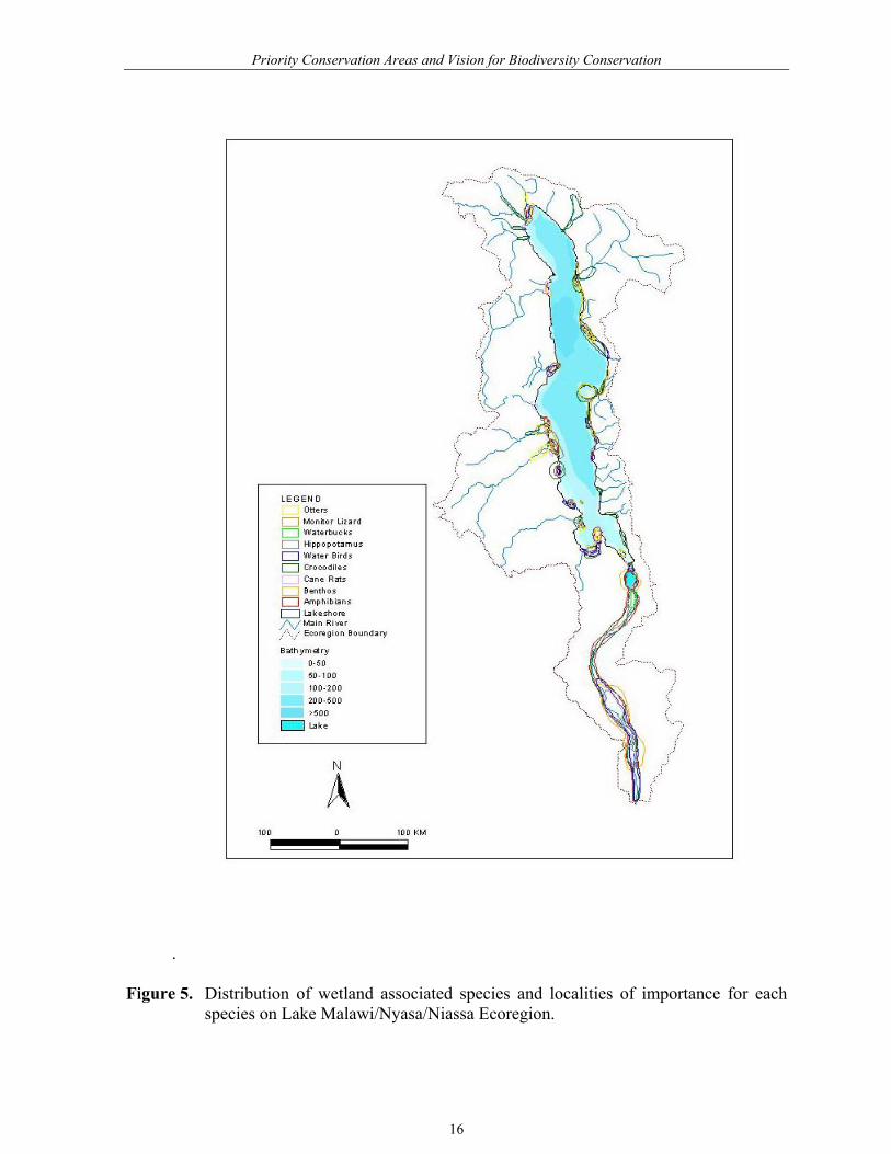
Most of the wetland-associated species are widely distributed in Africa, for example cane rat (Thryonomys swinderianus), waterbuck (Kobus ellipsiprymnus), and elephant (Loxodonta africana), and hence were regarded as much less important as the aquatic biodversity of the lake, especially the fishes. Consequently, when determining the overall biological priorities in the lake more weight was given to the zones identified for endemic fish species, than for the non-fish wetland-associated species. Lake Malawi/Niassa/Nyasa is recognised to be of global importance for its assemblage of endemic fish species, yet its wetland-associated assemblages of birds, mammals, reptiles and amphibians are only considered to be of regional significance. The biological data collected and assimilated in the workshop was therefore assessed in terms of the priority areas for the fish as one category, and for the wetland-associated species on the lake margins as another category. Combination of priorities for fish and wetland-associated species Due to their global importance, the zones of importance for endemic fish were more heavily weighted in the final analysis than were those for the associated wetland species. The three separate fish data layers (rocky islands, shallow waters, and river mouths) formed the basis of primary biological target areas identified here. The zones of maximum overlap for the various wetland associated birds, mammals, reptiles and amphibians provided some additional support to the identification of other important biodiversity areas around the lake (Figure 6). The combined biological map (Figure 6) shows the combined zones of biodiversity priority and hence where conservation investment should be focussed if the socio-economic threats and opportunities around the lake are not considered. It will be noted that these zones largely conform to the zones identified for endemic fish on their own, although the composite layers do increase the areas along the eastern lakeshore (Mozambique) and southern portions of Malawi. 6. THREATS TO THE LAKE ENVIRONMENT The socio-economic working group first produced a list of all potential threats to the long-term integrity of the lake ecosystem, biodiversity values and fishery productivity. This list was then prioritised to include only the five most important threats, which were then mapped (see Table 2). The most important threats coming from the land are those that result in enhanced run-off of sediment and nutrients into the lake causing eutrophication of the mesotrophic lake waters, thus allowing the growth of aquatic algae and invasive water plants. A hydrological and limnological working group identified those catchments from which highly nutrient and sediment-laden waters are entering the lake. Over time these inputs will alter the chemistry or condition of the lake’s water, encouraging algal blooms, increasing the incidence of sediment plumes, and encouraging invasion by plants such as water hyacinth. Such changes will affect the fish species composition, as the endemic fishes of the lake are adapted to clear and quite nutrient poor waters (Ribbink, 2001a) Of the seven catchments identified as depositing the largest volumes of sediment and nutrient into the lake, four are in Malawi, two are in Tanzania, and one is shared between Tanzania and Mozambique (Figure 7).
17
Priority Conservation Areas and Vision for Biodiversity Conservation
Figure 6. Combined priority areas for fish and wetland associated animals for the
freshwater systems of Lake Malawi/Nyasa/Niassa Ecoregion.
18
Priority Conservation Areas and Vision for Biodiversity Conservation
Many of these catchments contain significant levels of commercial tobacco growing and those in Tanzania are also found in steeper areas with higher rainfall, which enhances run-off into the lake. This provides a situation of combined siltation and nutrient loading. The most significant conservation threats to the lake, as indicated by overlaying all of the threat layers and producing an index of threat, are highest in those catchment areas with high levels of commercial agricultural activity on steep gradients. This therefore provides guidance on where conservation efforts need to be focused (Figure 8). Within the lake itself, the highest threat is found in the shallow waters of the southern part of the lake which has the largest expanse of shallow water combined with high numbers of endemic fish species. This area therefore also represents another clear focus for conservation attention.
7. OPPORTUNITIES FOR CONSERVATION AROUND THE LAKE The socio-economic working group also listed the major opportunities for biodiversity conservation of the lake. The list was then ranked in terms of its importance for preserving the biodiversity values of the lake, and these opportunities were mapped into ArcView GIS and were available for further analysis. A number of opportunities to enhance conservation of the Lake were identified. The most obvious of these involved some form of protection (either by state, or communally managed), or the possibility to develop or expand non-damaging or low-impact tourism initiatives (Figure 9). Other opportunities to assist the overall conservation of the Lake were identified as expanding or enhancing the off-shore fisheries which are regarded as under-exploited, to obtain greater harvests, and through this provide larger amounts of fish on local markets, effectively reducing the in-shore fisheries (Figure 10) which were regarded as overexploited. The use of lake water to irrigate farmland areas and hence reduce catchment run–off was also seen to be a possibility. Using the composite layers it was noted that that the greatest conservation opportunities are on the rivers on which the potamondromous fish species depend. This could be done by catchment management, especially the unspoilt rivers and catchments in Mozambique and Tanzania. Conservation of catchments is critical to maintaining the processes that support the terrestrial biodiversity, the riverine biodiversity and water quality may be maintained by reducing erosion and sedimentation.
8. WHERE DO OPPORTUNITIES OUTWEIGH THREATS The different map layers of socio-economic threat and socio-economic opportunity were first combined to produce a map showing consolidated zones of overall threats and opportunities across the ecoregion. Such a map allows us to look at those places where Opportunities outweigh threats and alternatively where threats outweigh opportunities. In a second step the threat and opportunity data were combined to develop a single spatial index of threat/opportunity for the biological values of the Lake Malawi/Niassa/Nyasa ecosystem. Each of the individually mapped threats and opportunities were assessed and ascribed scores to assist with the development of the overall index of relative threat vs. opportunity (Table 3).
19

Priority Conservation Areas and Vision for Biodiversity Conservation
Figure 7. Map of Lake Malawi/Nyasa/Niassa Ecoregion showing major sources of water inflow, sediments and nutrients.
20

Priority Conservation Areas and Vision for Biodiversity Conservation
Figure 8. Distribution and types of threats from land based human activities on the catchment areas of Lake Malawi/Nyassa/Niassa Ecoregion
21

Priority Conservation Areas and Vision for Biodiversity Conservation
Figure 9. Major areas of existing and potential biodiversity conservation on Lake Malawi/Nyasa/Niassa Ecoregion.
22
Priority Conservation Areas and Vision for Biodiversity Conservation
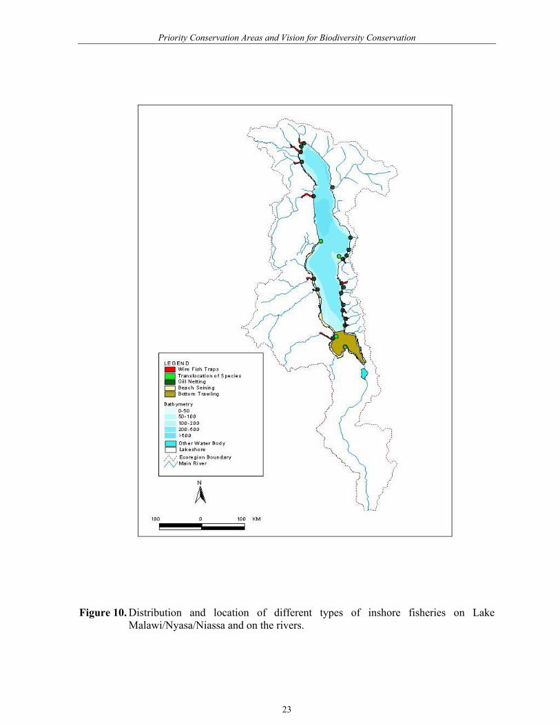
Figure 10. Distribution and location of different types of inshore fisheries on Lake
Malawi/Nyasa/Niassa and on the rivers.
23

Priority Conservation Areas and Vision for Biodiversity Conservation
The combination of the different data layers and the scores in Table 3 was made using ArcView Spatial Analyst GIS software. For ease of interpretation the final biological priorities were also mapped onto the same product so that threat and opportunity could be evaluated alongside biological importance. The combination of threats and opportunities mapped across the Lake Malawi/Niassa/Nyasa ecoregion shows some important trends (Figure 11). First, the major areas where threats overweigh opportunities are not on the lake or close to its margins. Instead, they are in some of the catchment areas of the lake where commercial tobacco farming and subsistence agriculture on steep slopes is causing significantly enhanced rates of nutrient and sediment run-off into the Lake Closer to the lake the opportunities for enhancing the conservation of the biological values tend to increase, particularly in a number of different zones. Areas of highest conservation opportunity are (a) in the southern part of the lake and (b) on the border between Tanzania and Mozambique and just to the south of this border within Mozambique. The southern end of the lake also has significant opportunities for enhanced conservation, particularly through the development of additional protected areas and further tourist development. Table 3: Scores used to make combined maps of threat and opportunity across the Lake
Malawi/Niassa/Nyasa ecoregion (positive scores are opportunities and negative scores are threats)
Main Attribute Issue Score
Threat Beach seining. -1 Bottom trawling -1 Deforestation -1 Fire -1 Gill netting. -1 Mining -1 Potential irrigation -1 Subsistence agriculture -2 Commercial tobacco -2 Translocated fish sites -2 Wire fish traps -1 Opportunities Existing CBNRM +2 Potential CBNRM +1 Existing protected area. +2 Potential protected area +1 Existing tourism +2 Potential tourism area +1
9. FINAL PRIORITY CONSERVATION AREAS We overlaid the combined threats and opportunities map with the biological values map and, in conjunction with expert knowledge, identified 20 priority conservation areas (Figure 12).
24

Priority Conservation Areas and Vision for Biodiversity Conservation
Conservation efforts will also have to be implemented well away from the lake itself by tackling gricultural and other land use issues.
Figure 11. Combined threats and conservation opportunities on Lake Malawi/Nyasa/Niassa Ecoregion.
25

Priority Conservation Areas and Vision for Biodiversity Conservation
.
Figure 12. Final priority areas for biodiversity conservation in the Lake Malawi/Nyasa/Niassa Ecoregion.
26

Priority Conservation Areas and Vision for Biodiversity Conservation
The workshop process concluded that the Lake Malawi-Niassa-Nyasa ecoregion is most threatened by the run-off from agricultural practices in southern Malawi and parts of Tanzania. This run-off, containing high sediment and/or nutrient loads is causing sediment plumes to spread into the lake and the nutrient-enriched water which is entering will over the long-term change the chemical composition of the waters of lake. This alone could damage key lake ecosystems and dramatically reduce biodiversity in these systems. In terms of fisheries, the most exploited section of the lake is at the southern and shallower end, where a combination of fishing pressures, eutrophication and fish translocations is causing some concerns to the fish biodiversity and the fisheries.
Conservation opportunities were also identified along the shores of Mozambique and Tanzania where populations of people are low and where there are still large areas of undisturbed coastal habitats and less exploited aquatic habitats. 10. PRIORITY CONSERVATION ACTIONS
The objectives for the ecoregion programme are:
• Conserve biodiversity of the lake by developing a network of protected areas (of varying forms) at village, district, national and tri-national levels.
• Promote sustainable use of biodiversity, particularly of fisheries, for the benefit of lake shore inhabitants and the ecoregion as a whole.
• Facilitate improved catchment management and land use to mitigate adverse downstream impacts on lake ecosystem processes.
• Build capacity and institutions at local, national and tri-national levels to conserve and manage natural resources in an integrated, adaptive coordinated manner across the ecoregion
Each objective is accompanied by a set of activities (with their associated inputs in the form of operational funds and equipment), which need to be carried out in order to achieve the objective. The objectives as stated are very broad but they are more clearly defined in operational terms by verifiable indicators that specify what will be accomplished in terms of quantity, quality, where, and when. These details are elaborated in a Logical Framework (this has still to be developed but see Objective Tree in Appendix 1a). The planning process undertaken with stakeholders around Lake Malawi developed a matrix of priority conservation actions. These actions, if implemented, would ensure the long-term survival of the biological values of the lake, and the fisheries productivity which supports the livelihoods of millions of poor people in the surrounding countries. The most important conservation actions for conserving the lake have been identified as follows:
27

Priority Conservation Areas and Vision for Biodiversity Conservation
1) Reduce eutrophication of the lake’s waters to levels that will not cause damaging changes to biodiversity and fisheries productivity.
2) Maintain stocks of river-breeding fish species above levels that could cause damaging
changes to biodiversity and fisheries productivity, especially in those rivers being impacted by eutrophication or inappropriate fishing practices.
3) Maintain populations of Mbuna fish species above levels that could cause damaging
changes to biodiversity and fisheries productivity, especially in those areas being impacted by eutrophication or inappropriate fishing practices.
4) Establish and maintain institutional mechanisms that facilitate collaboration and
cooperation amongst role-players who impact upon the use and management of lake based resources and habitats.
These conservation targets have been used to develop a matrix of strategies and actions that will assist the conservation of the lake Malawi-Niassa-Nyasa ecosystem in the longer term. The matrix is presented below (Appendix Ib). 11. WAY FORWARD 11.1 Initiate a consultative process to develop a Trilateral Agreement or Convention
leading to the formation of Trilateral Commission. 11.2 Develop a Conservation Action Plan for the ecoregion. 11.3 Facilitate the desigination of the entire lake as a Ramsar site by the three riparian
states in their respective territories. 11.4 Fundraise and implement the agreed project activities. 12. REFERENCES Abdallah, A.M. 2000. Nearshore benthic macroinvertebrates of Lake Malawi/Nyasa. (East
Africa). MSc Thesis in Biology, University of Waterloo
Abell, R. et al. In prep. Freshwater ecoregions of the world. WWF-US, Washington, DC, USA.
Ansell, W.F.H. and Dowsett, R.J. 1988. Mammals of Malawi: an annotated checklist and atlas. Trendrine Press, St. Ives
Baillie, J. and Groombridge, B. 1996. IUCN Red List of Threatened Animals. IUCN-The World Conservation Union, Geneva
Benson, C.W. and Benson, F.M. 1977. The birds of Malawi: a supplement to Newman's birds of Southern Africa. Montfort Press, Malawi
Bernacsek, G.M., A. Massinga and P. Contreras. 1983. Exploratory gillnetting in Lake
28

Priority Conservation Areas and Vision for Biodiversity Conservation
Niassa, Mozambique, with biological profiles of the main taxa caught. FAO/GPC/MOZ/006/SWE. Field Doc. (5). 129 p.
Blaustein, A.R. and Wake, D.B. 1990. Declining amphibians: a global phenomenon? Trends in Ecology and Evolution, 5:203-204
Booth, V. (2000) Lake Malawi/Niassa/Nyasa ecoregion: socio-economic reconnaissance. WWF, Harare, Zimbabwe.
Chafota J. (2001) Lake Malawi/Niassa/Nyassa Ecoregion: Report on the Reconnaissance
Workshop. WWF-SAPRO. Cooley, P.M. (2000) A Biodiversity Atlas for Lake Malawi/Nyasa/Niassa. SADC/GEF Lake
Malawi Biodiversity Conservation Project. CEOS Technical Report 7 – 1 – 00. Fryer, G. 1959. The trophic interrelationships and ecology of some littoral communities of
Lake Nyasa with special reference to the fishes, and a discussion of the evolution of a group of rock-frequenting Cichlidae. Proceedings of the Zoological Society of London, 132(2):153-281
Government of Malawi, Department of Research and Environmental Affairs 1994. Malawi National Environmental Action Plan. Department of Research and Environmental Affairs, Lilongwe, Malawi
Groombridge, B. and M. Jenkins. 1998. Freshwater biodiversity: a preliminary global assessment. WCMC Biodiversity Series 8. World Conservation Monitoring Centre, Cambridge, UK
Johnson, S. and Chafota, J. (2002) Consolidated report for national stakeholder consultative
workshops for Lake Malawi-Niassa-Nyasa. WWF Southern African Regional Programme Office, Harare, Zimbabwe.
Mkandawire, R.M. and S.K. Chimatiro. 1991. Fishermen, processors and traders on Likoma and Chizumulu Islands (unpublished). Munthali, S.M. 1998. Biological diversity. In: State of Environment Report for Malawi 1998.
Government of Malawi, Environmental Affairs Department, Lilongwe, Malawi.
Myer, A. (1993). Phylogenetic relationships and evolutionary processes in East African cichlid fishes. Trends in Ecology and Evolution, 8, 279-284.
Newman, K., Johnston-Stewart, N., and Medland, B. 1992. Birds of Malawi: a supplement to
Newman's birds of Southern Africa. Lakeside Publications, Halfway House, Southern Africa. Uniform title: Birds of southern Africa Series note: The third in a series of regional field guides
Olson, D.M., & Dinerstein, E. (1998). The Global 200: a representation approach to conserving the earth’s most biologically valuable ecoregions. Conservation Biology, 12, 502-515.
29

Priority Conservation Areas and Vision for Biodiversity Conservation
Olson, D.M., Dinerstein, E., Wikramanayake, E.D., Burgess, N.D., Powell, G.V.N., Underwood, E., D’Amico, J.A., Strand, H.E., Morrison, J.C., Loucks, C.J., Allnutt, T.F., Lamoreux, J.F., Ricketts, T.H., Itoua, I., Wettengel, W.W. & Kura, Y. (2001). A New Map of the World. Bioscience, 51, 933-938.
Page, L. M. & Burr, B.M. 1991. A field guide to freshwater fishes: North America north of
Mexico. Houghton Mifflin Co., New York, NY.
Poynton, J.C. and Broadley, D.G. 1991. Amphibia Zambesia ca: 5. Zoogeography. Annals of the Natal Museum, 32:221-277
Ribbink, A.J. 1992. Biodiversity and speciation of freshwater fishes with particular reference to African cichlids. In: Aquatic Ecology : Scale, Pattern and Process. P.S. Giller, A.G. Hildrew, and D.G. Raffaelli (editors). Blackwell Scientific Publications, Oxford
Ribbink, A.J. 2001a. Lake Malawi/Niassa/Nyasa Ecoregion: Biophysical Reconnaissance. WWF Southern African Regional Programme Office, Harare, Zimbabwe. 296p.
Ribbink, A.J. 2001b. Lake Malawi/Niassa/Nyasa: Biodiversity Hotspot, Food-basket and a
potential Transfrontier Conservation Area. Conservation International, Cape Town. Ribbink, A.J., Marsh, B.A., Marsh, A.C., Ribbink, A.C. and Sharp, B.J. 1983. A preliminary
survey of the cichlid fishes of rocky habitats in Lake Malawi. South African Journal of Zoology, 18(3):149-310.
SADC/GEF Lake Malawi/Nyasa/Niassa Biodiversity Conservation Project, Senga Bay. Pp.
29-69. Saket, M. 1994. Report on the Updating of the Exploratory National Forest Inventory.
FAO/UNDP, MOZ/92/013. 61p.
Smithers, R.H.N. and Tello, J.L.T.L. 1976.Checklist and atlas of the mammals of Mozambique. National museum of Southern Rhodesia. Museum memoir 9:1-147
Stattersfield, A.J., Crosby, M.J., Long, A.J. and Wege, D.C. 1998. Endemic bird areas of the
world: priorities for biodiversity conservation. Birdlife International, Cambridge, UK. Birdlife Conservation Series No 7
Vincent, J. 1933. The birds of northern Portugese East Africa. Ibis, 1933:611-652
Vincent, J. 1934. The birds of northern Portugese East Africa. Ibis, 1934:126-160, 300-340, 495-527, 757-799
Vincent, J. 1935. The birds of northern Portugese East Africa. Ibis, 1935:1-37, 355-397, 485-529, 707-762
Vincent, J. 1936. The birds of northern Portugese East Africa. Ibis, 1936:48-125
30

Priority Conservation Areas and Vision for Biodiversity Conservation
APPENDIX 1A OBJECTIVES TREE (OUTLINE OF A LOGFRAME)
Goal (Vision) : A clean, healthy and living lake where resources are being used in ways that improve and support human well being without reducing the natural capital of the system; a lake where the full range of biological diversity is being maintained; where catchment and atmospheric inputs to the lake are known and are not compromising its health; and, where the functional integrity and evolutionary capacity of the lake ecosystem is being maintained.
Purpose: • Conserve biodiversity of the lake by developing a network of protected areas at
village, district, national and tri-national levels. • Promote sustainable use of biodiversity, particularly of fisheries resources, for the
benefit of lake shore inhabitants and the ecoregion as a whole. • Facilitate improved catchment management and land use to mitigate adverse
downstream impacts on the structure and functioning of the lake ecosystem. • Build capacity and institutions at local, national and tri-lateral levels to conserve and
manage natural resources in an integrated, adaptive coordinated manner across the ecoregion
OUTPUTS: #1. Network of shoreline village, national and trans-boundary protected areas of various kinds that cover sites of critical importance extended.
#2. Integrated water management, conservation and sustainable use projects in selected catchments and the lake implemented.
#3. Development of policies, incentives and institutions that promote conservation and sustainable use of natural resources facilitated.
#4. The development of tri-lateral and national agreements and institutions to coordinate and integrate conservation and sustainable use of natural resources in the ecoregion supported
#5. Capacity at tri-national, national and local levels to implement ecoregion conservation supported
#6. Project management and coordination mechanisms in place and operational.
31
Priority Conservation Areas and Vision for Biodiversity Conservation
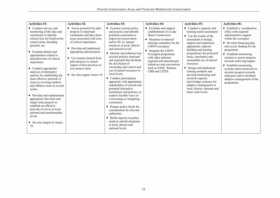
Activities #1: • Conduct surveys and monitoring of the lake and catchments to identify critical sites for biodiversity conservation, breeding grounds, etc.
• Examine threats and opportunities related to identified sites of critical importance.
• Conduct appropriate analyses of alternative options for establishing the most effective network of reserves covering onshore and offshore areas at several scales.
• Develop and implemented appropriate fast track and longer term projects to establish an effective network of rsrves at local, national and transboundary levels.
• See also targets in Annex 1b.
Activities #2: • Assess potential for pilot
projects in important catchments and lake shore areas associated with sires of critical importance.
• Develop and implement appropriate pilot projects
• Use lessons learned from pilot projects to extend impact of best practices to new project areas
• See also targets Annex 1b
Activities #3: • Examine current policy
and practice and identify potential constraints to improved conservation and/or SU of natural resources at local, district and national levels
• Identify and influence key sectoral policies (national and regional) that facilitate the devolution of ownership and control and use of natural resources to local levels.
• Conduct participatory appraisals with appropriate stakeholders of current and potential alternative institutions and policies, to explore feasible ways of overcoming or mitigating constraints.
• Prepare policy briefs for consideration by relevant authorities
• Build capacity in policy analysis and development at local, district and national levels.
Activities #4: • Facilitate and support
establishment of a Lake Basin Commission
• Maintain tri-national steering committee for the LMNN ecoregion
• Integrate the LMNN Ecoregion programme with other national, regional and international initiatives and conventions such as SADC, Ramsar, CBD and CITES.
Activities #5: • Conduct a capacity and
training needs assessment • Use the results of the
assessment to design, support and implement appropriate capacity building and training programmes for protected areas, sanctuaries and sustainable use of natural resources.
• Design and implement training modules and develop monitoring and research capacity (knowledge systems) for adaptive management at local, district, national and basin wide levels.
Activities #6: • Establish a coordination office with required administrative support within the ecoregion • Develop financing plan and secure funding for the programme • Establish monitoring systems to assess progress towards achieving targets. • Establish monitoring systems and/or protocols to monitor progress towards indicators and to facilitate adaptive management of the programme.
32
Priority Conservation Areas and Vision for Biodiversity Conservation
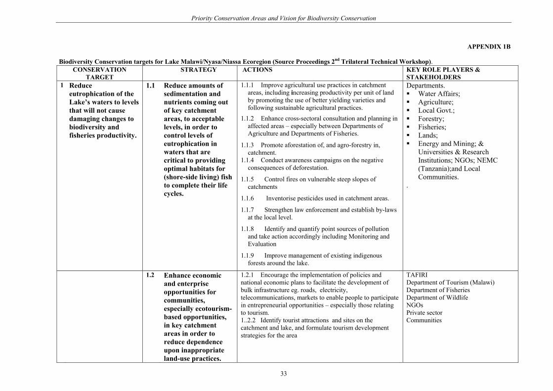
APPENDIX 1B Biodiversity Conservation targets for Lake Malawi/Nyasa/Niassa Ecoregion (Source Proceedings 2nd Trilateral Technical Workshop).
CONSERVATION TARGET
STRATEGY ACTIONS KEY ROLE PLAYERS & STAKEHOLDERS
1 Reduce eutrophication of the Lake’s waters to levels that will not cause damaging changes to biodiversity and fisheries productivity.
1.1 Reduce amounts of sedimentation and nutrients coming out of key catchment areas, to acceptable levels, in order to control levels of eutrophication in waters that are critical to providing optimal habitats for (shore-side living) fish to complete their life cycles.
1.1.1 Improve agricultural use practices in catchment areas, including increasing productivity per unit of land by promoting the use of better yielding varieties and following sustainable agricultural practices.
1.1.2 Enhance cross-sectoral consultation and planning in affected areas – especially between Departments of Agriculture and Departments of Fisheries.
1.1.3 Promote aforestation of, and agro-forestry in, catchment.
1.1.4 Conduct awareness campaigns on the negative consequences of deforestation.
1.1.5 Control fires on vulnerable steep slopes of catchments
1.1.6 Inventorise pesticides used in catchment areas.
1.1.7 Strengthen law enforcement and establish by-laws at the local level.
1.1.8 Identify and quantify point sources of pollution and take action accordingly including Monitoring and Evaluation
1.1.9 Improve management of existing indigenous forests around the lake.
Departments. Water Affairs; Agriculture; Local Govt.; Forestry; Fisheries; Lands; Energy and Mining; &
Universities & Research Institutions; NGOs; NEMC (Tanzania);and Local Communities.
.
1.2 Enhance economic and enterprise opportunities for communities, especially ecotourism-based opportunities, in key catchment areas in order to reduce dependence upon inappropriate land-use practices.
1.2.1 Encourage the implementation of policies and national economic plans to facilitate the development of bulk infrastructure eg. roads, electricity, telecommunications, markets to enable people to participate in entrepreneurial opportunities – especially those relating to tourism. 1..2.2 Identify tourist attractions and sites on the catchment and lake, and formulate tourism development strategies for the area
TAFIRI Department of Tourism (Malawi) Department of Fisheries Department of Wildlife NGOs Private sector Communities
33

Priority Conservation Areas and Vision for Biodiversity Conservation
CONSERVATION TARGET
STRATEGY ACTIONS KEY ROLE PLAYERS & STAKEHOLDERS
1.3 Enhance the participation of communities in the management of natural resources management.
1.3.1 Facilitate the establishment of CBNRM institutions and mechanisms that enable communities to participate in natural resource management decision-making processes. 1.3.2 Encourage the development of NRM related policies that enhance community tenure and proprietorship over land and natural resources
2 Maintain stocks of river-breeding fish species above levels that could cause damaging changes to biodiversity and fisheries productivity, especially in those rivers being impacted by eutrophication or inappropriate fishing practices.
2.1 Manage and controlfisheries and fishing practices in areas identified as being critical for breeding, or for completing life-cycles of river-breeding fish.
2.1.1 Identify key breeding sites, and areas or habitats critical to the completion of fish life cycles. 2.1.2 Determine and characterize fish stocks 2.1.3 Enforce fishing laws and regulations 2.1.4 Create awareness of the importance of the life-cycle of fish 2.1.5 Explore development of fish breeding and restocking projects 2.1.6 Control construction of weirs and traps 2.1.7 Control fishing at river mouths 2.1.8 Control river-bank cultivation. 2.1. 9 Establish and implement monitoring programmes.
TAFIRI / MAFRI Research Institutions Department of Fisheries Department of Wildlife Local Government Communities UNIMA (Mberu - Malawi) Bureau of Standards NRC
2.2 Establish multiple-use protected areas that incorporate habitats important to the completion of life cycles of those species of fish considered to be below viable population levels.
2.2.1 Each riparian state to identify, and designate at least two core areas as nationally important protected regions along their coastline, and implement plans to manage or enforce sustainable fishing practices in those areas. 2.2.2 All districts along the shoreline of all three riparian countries should identify at least one area for protection. 2.2.3 Identify species of fish below viable population levels 2.2.4 Identify key breeding sites, and areas or habitats critical to the completion of fish life cycles 2.2.5 Promulgate legislation to enable the establishment of multiple-use protected areas 2.2.6 Negotiate development of multiple-use protected areas with affected communities or stakeholders, including the development of relevant management institutions and coordination mechanisms 2.2.7 Staff and resource multiple-use protected areas.
District Authorities and communities TAFIRI / MAFRI Research Institutions Department of Fisheries Communities
34

Priority Conservation Areas and Vision for Biodiversity Conservation
CONSERVATION TARGET
STRATEGY ACTIONS KEY ROLE PLAYERS & STAKEHOLDERS
2.3 Support communityparticipation in the management of fisheries and key fish habitats.
2.3.1 Facilitate the establishment of community based institutions and mechanisms that enable communities to participate in the management and decision-making processes relating to river-breeding fish and the habitats that the fish are dependant upon. 2.3.2 Facilitate the establishment of community based schemes and markets that optimise the value of fish harvesting processes.
TAFIRI Department of Tourism (Malawi) Department of Fisheries Department of Wildlife NGOs Private sector. Communities
2.4 Facilitate the access of river-based communities to a broader range of economic and enterprise opportunities, especially ecotourism-based opportunities, in order to reduce dependence upon fish harvesting as a single livelihood strategy.
2.4.1 Encourage the development and implementation of policies and national economic plans that enable communities to access support and micro-financing for entrepreneurial activities and opportunities apart from fishing – especially those relating to tourism. 2.4.2 Identify alternative economic activities that are appropriate to communities that impact significantly upon river-breeding fish species and the habitats that the fish are dependant upon. 2.4.3 Identify tourist attractions and sites along river systems and in catchment areas.
2.5 Enhance knowledge,database and understanding of key watershed ecosystems and natural resources (including species/population inventories) as well as natural resources management and use processes.
2.5.1 Carry out ecological and socio-economic research on the lake and its catchment. 2.5.2 Carry out research to have base line data on biodiversity and limnology as well as other data/knowledge gaps. 2.5.3 Gather, store, analyse and disseminate information in a manageable form. 2.5.4 Establish an annual catch assessment programme 2.5.5 Implement research (EIA) on the impacts of the mining industry on the environment of the lake and its catchment.
TAFIRI Research Institutions Department of Fisheries Department of Wildlife Departments of Environmental Affairs Local Government Communities Universities NGOs
35

Priority Conservation Areas and Vision for Biodiversity Conservation
CONSERVATION TARGET
STRATEGY ACTIONS KEY ROLE PLAYERS & STAKEHOLDERS
1. Maintain populations of Mbuna fish species above levels that could cause damaging changes to biodiversity and fisheries productivity, especially in those areas being impacted by eutrophication or inappropriate fishing practices.
3.1 Manage and controlfisheries and fishing practices in areas identified as being critical for breeding, or for completing life-cycles of Mbuna fish species.
3.1.1 Identify key breeding sites, and areas or habitats critical to the completion of Mbuna fish life cycles. 3.1.2 Quantify and describe stocks available. 3.1.3 In consultation with communities and community authority structures, enforce fishing laws and regulations. 3.1.4 Create awareness of the biodiversity importance of the Mbuna species. 3.1.5 Explore development of fish breeding and restocking projects of those species known to be critically endangered. 3.1.6 Establish and implement monitoring programmes. 3.1.7 Control beach seining, and reinforce closed season. 3.1.8 Strengthen cooperation between Fisheries Department and community 3.1.9 Limit number of fishers through CBNRM processes. 3.1.10 Enforce regulations on translocation and extraction of fish species such as the ‘mbunas’ 3.1.11 Facilitate the establishment of CBNRM schemes which enhance enterprise development and optimise the value of fish harvesting processes. 3.1.12 Promote the use of recommended fishing gears and control fishing effort.
TAFIRI / MAFRI Research Institutions Department of Fisheries Department of Wildlife Local Government Communities UNIMA (Mberu - Malawi) NRC
3.2 Establish multiple-use protected areas that incorporate important habitats.
3.2.1 Identify key breeding sites, and areas or habitats critical to the completion of fish life cycles. 3.2.2 Create awareness about the negative impact of using beach seine nets. 3.2.3 Identify tourist attractions and sites on the catchment and lake.
36

Priority Conservation Areas and Vision for Biodiversity Conservation
3.3 Enhance knowledge,database and understanding of key ecosystems and natural resources (including species/population inventories) as well as natural resources management and use processes.
3.3.1 Carry out ecological and socio-economic research on the lake and its catchments on particular species 3.3.2 Carry out research to have base line data on biodiversity and limnology as well as other data/knowledge gaps. 3.3.3 Gather, store, analyse and disseminate information in a manageable form. 3.3.4 Establish an annual catch assessment programme 3.3.5 Establish a monitoring programme for ornamental fish trade.
TAFIRI Research Institutions Department of Fisheries Department of Wildlife Departments of Environmental Affairs Local Government Communities Universities NGOs
4 Establish and maintaininstitutional mechanisms that facilitate collaboration and cooperation amongst role-players who impact upon the use and management of lake based resources and habitats.
4.1 Develop tri-lateral, national and local forums that enable all LMNN stakeholders to participate in decision-making processes relating to the management and use of the lake, its natural resources and habitats.
4.1.1 Develop tri-lateral joint-management mechanisms for the collaborative management of LMNN. 4.1.2 Develop integrated plans for the collaborative, joint-management of LMNN. 4.1.3 Carry out joint research, planning and implementation of projects. 4.1.4 Carry out exchange visits and exchange of information. 4.1.5 Harmonise relevant legislation on natural resources management and use between involved countries.
TAFIRI MAFIRI Research Institutions Department of Fisheries Department of Wildlife Departments of Environmental Affairs Ministry of Foreign Affairs Communities Universities NGOs (International & Local)
4.2 Promote the participation of traditional authorities and CBNRM institutions in the use and management of the lake, its habitats and natural resources.
4.2.1 Engage with communities and traditional authorities, and work with them to link into existing social institutions or develop new ones, in order to facilitate the introduction of CBNRM into these processes.
4.3 Engage international NGOs and development agencies to facilitate collaboration and cooperation in the management and use of the lake, its habitats and natural resources.
4.3.1 Link with relevant NGOs, development agencies and regional governance mechanisms to establish protocols and memoranda-of-understanding. 4.3.2 Develop project proposals that promote enhanced management and use of the lake, its habitats and natural resources.
37
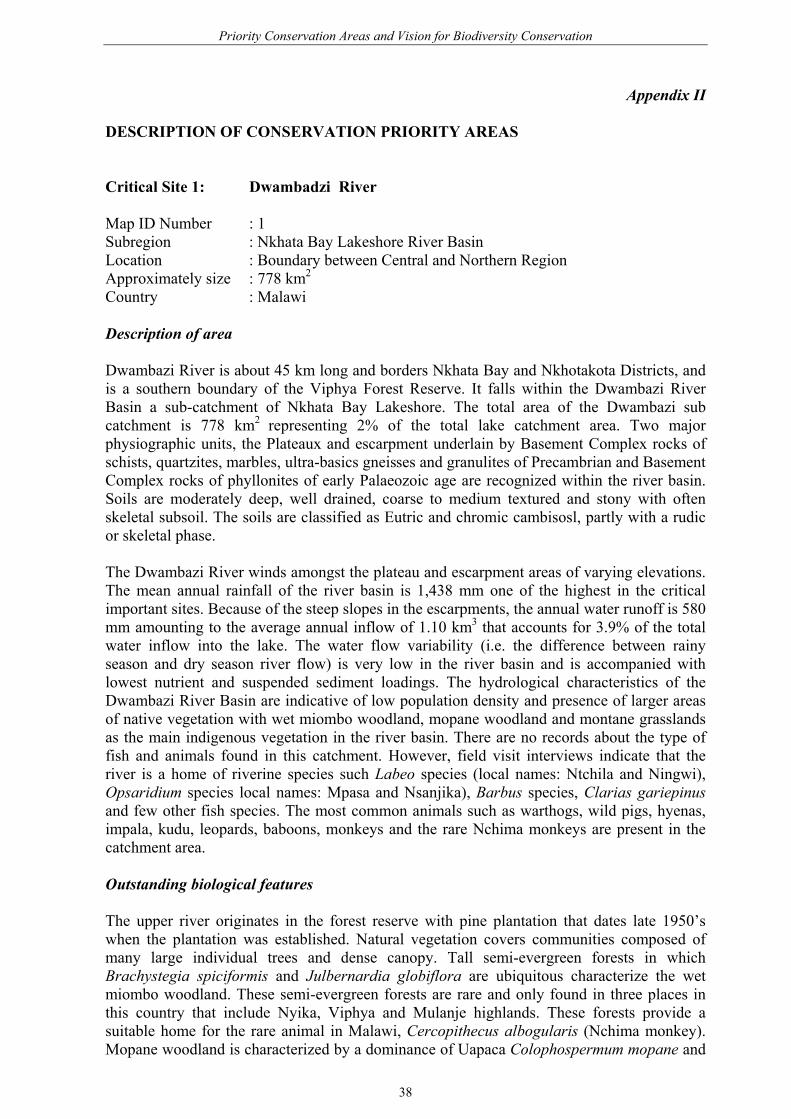
Priority Conservation Areas and Vision for Biodiversity Conservation
Appendix II DESCRIPTION OF CONSERVATION PRIORITY AREAS Critical Site 1: Dwambadzi River Map ID Number : 1 Subregion : Nkhata Bay Lakeshore River Basin Location : Boundary between Central and Northern Region Approximately size : 778 km2
Country : Malawi Description of area Dwambazi River is about 45 km long and borders Nkhata Bay and Nkhotakota Districts, and is a southern boundary of the Viphya Forest Reserve. It falls within the Dwambazi River Basin a sub-catchment of Nkhata Bay Lakeshore. The total area of the Dwambazi sub catchment is 778 km2 representing 2% of the total lake catchment area. Two major physiographic units, the Plateaux and escarpment underlain by Basement Complex rocks of schists, quartzites, marbles, ultra-basics gneisses and granulites of Precambrian and Basement Complex rocks of phyllonites of early Palaeozoic age are recognized within the river basin. Soils are moderately deep, well drained, coarse to medium textured and stony with often skeletal subsoil. The soils are classified as Eutric and chromic cambisosl, partly with a rudic or skeletal phase. The Dwambazi River winds amongst the plateau and escarpment areas of varying elevations. The mean annual rainfall of the river basin is 1,438 mm one of the highest in the critical important sites. Because of the steep slopes in the escarpments, the annual water runoff is 580 mm amounting to the average annual inflow of 1.10 km3 that accounts for 3.9% of the total water inflow into the lake. The water flow variability (i.e. the difference between rainy season and dry season river flow) is very low in the river basin and is accompanied with lowest nutrient and suspended sediment loadings. The hydrological characteristics of the Dwambazi River Basin are indicative of low population density and presence of larger areas of native vegetation with wet miombo woodland, mopane woodland and montane grasslands as the main indigenous vegetation in the river basin. There are no records about the type of fish and animals found in this catchment. However, field visit interviews indicate that the river is a home of riverine species such Labeo species (local names: Ntchila and Ningwi), Opsaridium species local names: Mpasa and Nsanjika), Barbus species, Clarias gariepinus and few other fish species. The most common animals such as warthogs, wild pigs, hyenas, impala, kudu, leopards, baboons, monkeys and the rare Nchima monkeys are present in the catchment area. Outstanding biological features The upper river originates in the forest reserve with pine plantation that dates late 1950’s when the plantation was established. Natural vegetation covers communities composed of many large individual trees and dense canopy. Tall semi-evergreen forests in which Brachystegia spiciformis and Julbernardia globiflora are ubiquitous characterize the wet miombo woodland. These semi-evergreen forests are rare and only found in three places in this country that include Nyika, Viphya and Mulanje highlands. These forests provide a suitable home for the rare animal in Malawi, Cercopithecus albogularis (Nchima monkey). Mopane woodland is characterized by a dominance of Uapaca Colophospermum mopane and
38

Priority Conservation Areas and Vision for Biodiversity Conservation
Pterocarpus angolensis. Other tree species include Terminalia sevucea, Afzelia quanzensis, Adenia microcephala and Pericopsis angolensis. The Dwambadzi River is a spawning and nursery area for potamodromous fish species such as Opsaridium and Labeo species.. The relatively undisturbed riverine environment contributes towards ensuring an adequate supply of clean water for spawning fish. Current conservation status The Dwambazi River Basin except the lower reaches is in the Forest Reserve designated to protect forests currently administered by the Department of Forest. Due to technical and financial constraints, the Forest reserve is not properly managed. The lower reaches of the basin, the lakeshore plain is a small area that is not in any formal conservation status. Current resource use Maize and cassava gardens and settlements occupy steep slopes in the escarpments and most the areas of the lakeshore plain of the Dwambazi River Basin while most of the catchment area is still in pristine condition representing probably one of the few areas in the country with minimum human disturbance. The forest plantation that is now commercially used for logging timber is found in the highlands where the river originates. Small-scale commercial fishery occurs in the lower areas of the Dwambazi River, and is pronounced at the mouth. Description of threats Deforestation, overfishing, uncontrolled bushfire, insufficient knowledge of importance of biodiversity, illegal hunting and the current clear felling of the plantations with the associated activities of heavy logging vehicles are a threat to the basin. Deforestation is caused by unplanned settlements on the steep slopes and cultivation on steep slopes of the escarpments and riverbanks. Deforestation, harvesting of the plantation without afforestation, bushfires and shifting cultivation all result in soil erosion thereby increasing runoff and siltation of the river channel. Because of siltation of the river channel flash floods in the lower reaches of the river are common during the rainy season. Reasons for definition/identification The Dwambazi River Basin is probably one of few river basins in the country with minimum human disturbance. Most of the catchment area is still in pristine condition with the exception of small areas in the escarpments and the lower reaches. However, its topographic areas of steep slopes with unstable soils make it vulnerable to erosion and irreversible degradation. Relevant conservation and management agencies • Forest Department Evangelical • Lutheran Development Programme (ELDP) • Environmental Society of Malawi (WESM) • Wildlife Clubs • Fisheries Department • Beach Village Committee (BVCs) • Ministry of Agriculture.
39

Priority Conservation Areas and Vision for Biodiversity Conservation
Recommendations for future conservation options Efforts should be made to maintain the existing protected areas in the catchment areas through strengthening law enforcement. Given the current ineffectiveness of enforcement, a joint function among government departments and resource user organizations is recommended. Public awareness and campaigns about the importance of natural resources, sustainable utilization of the natural resources, family planning and HIV/AIDS should run parallel to efforts of improving law enforcements. Critical Site 2: Kande-Chintheche Lakeshore Area Map ID Number : 2 Subregion : Nkhata Bay Lakeshore River Basin Location : Northern Region in Nkhata Bay District Approximately size : 54 km
Country : Malawi Description of the Kande-Chintheche Lakeshore area The Kande-Chintheche Lakeshore area is the coastal area South of Nkhata Bay District between Rivers Dwambadzi (site 1) and Luweya (site 2). It is about 54 km long consisting of a narrow flat area along the lakeshore, lying below the eastern scarp of South Viphya Hills. In some places, steep hillside cliffs drop directly into the lake leaving no land for settlement or agricultural activities. Kande-Chintheche coastal area has a similar geology, hydrology, climate pattern, vegetation cover and fauna characteristics to Dwambadzi Catchment area, as it is part of the river basin. More than 150 fish species endemic to lake belonging to rocky, benthic and pelagic communities are found in the shallow waters of the lake in the eastern part of the lakeshore plain area. Although there is lack of baseline quantifiable data on the area, this area is characterised by numerous streams that cause flash flooding in the narrow stretch of the lakeshore plain area. This area is very sensitive to any environmental disturbance be it caused by nature or human. Because of the topographic nature of the area, only scattered patches of land in the lakeshore plain are under cultivation. Outstanding biological features The semi-green forest dominated by Brachystegia spiciformis and Julbernardia globiflora are the prominent natural vegetation of the area, and the rare animal in the country, Cercopithecus albogularis (Nchima monkey) take refuge within the canopy. There are also scattered plantations of Pinus and Eucalyptus within the areas. The shallow waters of the lake found in the eastern part of the plan area harbours a diverse of more 150 fish species endemic to lake. The fish species belong to the three main communities, the pelagic, the benthic and the rocky. The pelagic community is dominated by the cyprinid Engraulicypris sardella, by small and large cichlids species of the genera Copadichromis, Oreochromis and Buccochromis, respectively and the rocky by the most colour Mbuna species. The Mbuna species are very territorial fish species and sensitive to any habitat degradation and vulnerable to overfishing. Similarly, the large cichlids of the genera Oreochromis and Buccochromis are prone to overfishing. The shallow waters along the coastal area provide feeding as well as spawning grounds for these species.
40

Priority Conservation Areas and Vision for Biodiversity Conservation
Current conservation status The escarpment areas are the zones that fall within the forest reserve and the lakeshore plain is not protected. Current resource use The lakeshore plain areas are under shifting cultivation for mainly cassava and maize. Private entrepreneurs use the lakeshore beaches for sand mining as well as for construction of lake resorts. A small-scale commercial fishery of the benthic fish communities that include potamodromous fish species is located in the shallow areas of the lake. Description of threats Natural events such as flash flooding, deforestation, settlements and cultivation on scarp slopes, and projects are great concerns in the escarpment zones. Although much of the scarps are under forest, there is heavy runoff in these areas and flash floods are very common during the rainy season. This is exacerbated by poor land husbandry and unplanned settlements accompanied by deforestation in the scarps areas adjacent to the lakeshore plain. Beach degradation through sand mining or cottage building promotes erosion along the coastal line. This in turn degrades suitable habitats for fish in shallow waters. The fisheries based on large fish species such as Oreochromis species are on the decline due to heavy fishing pressure. Projects such as road construction that involves digging and cutting some hills have destroyed the natural vegetation and increased soil erosion in the scarps. Reasons for definition/identification The Kande-Chintheche Lakeshore area like the Dwambadzi River Basin is probably one of few river basins in the country with minimum human disturbance. Most of the catchment area is still in pristine condition with the exception of small areas in the escarpments and the lower reaches. However, its topographic areas of steep slopes with unstable soils make it vulnerable to erosion and irreversible degradation. Relevant conservation and management agencies • Forest Department • Evangelical Lutheran Development Programme (ELDP) • Environmental Society of Malawi (WESM) • Wildlife Clubs • Fisheries Department • Beach Village Committee (BVCs) • Ministry of Agriculture. Recommendations for future conservation options Efforts should be made to maintain the existing protected areas in the catchment areas through strengthening law enforcement. Given the current ineffectiveness of enforcement, a joint function among government departments and resource user organizations is recommended. Public awareness and campaigns about the importance of natural resources, sustainable utilization of the natural resources, family planning and HIV/AIDS should run parallel to efforts of improving law enforcements. An under-exploited offshore fish stock gives an opportunity to reduce high fishing pressure on shallow water fish stocks. Promotion
41

Priority Conservation Areas and Vision for Biodiversity Conservation
or expansion of non-damaging or low-impact tourism initiatives provides as an alternative source of income to people that will reduce pressure on the natural resources. Critical Site 3: Bua River Map ID Number : 3 Subregion : Bua River Basin Location : Central Region in Nkhota kota District Approximately size : 10,700 km2
Country : Malawi Description of area Bua River is 255 km long. Rusa and Namitete rivers are its major tributaries. Its total catchment area is about 10,700 km2, which is the second largest lake catchment area in the country. The Bua Catchment area has four major physiographic zones at different elevations namely highlands, plateaux, escarpments and lakeshore plain. The highlands and plateaux are found at the highest elevation and the lakeshore plains at the lowest. The river basin originates from the highlands of the Mchinji Hills that border Malawi and Zambia in the West and are underlain by the Basement Complex rocks of the Pre-cambrian and Cambrian age, consisting mainly of charnockitic gneisses and granulites. The Basement Complex rocks, consisting mainly of schists, quartzites, marbles, ultra-basics gneisses and granulites rocks are found in plateau and escarpment zones. The lakeshore is underlain by Cenozoic Lake Sediments. There is a mosaic of soil types in the river basin. Deep soils good for agriculture are predominant in the highlands, which is evidenced by the continuing clearing of the highland vegetation. Loamy soils are prevalent in the cultivated Lilongwe-Kasungu plain situated on the plateau area before the escarpment zone in the Nkhota Kota Game Reserve. The plain areas on the plateau are the largest part of the river basin area and constitute about 45.7% of the total catchment area. Because of its fertile soils, much of this area is arable land with high pervasiveness of tobacco estates and maize farms. Moderately deep to deep, well drained, course to medium over medium to fine textured with skeletal subsoil in some places classified as Haplic Lixsols and Ferric Livisols are a common feature of the scarps. The lakeshore plain soils are mainly shallow to moderately deep, well drained, medium textured, brown to yellowish red and stony and are classified as Ferralic, Eutric or Chromic Cambisols or Haplic Lixisols, partly Rudic, Sketetic or Lithic phase. The annual mean rainfall of the basin is 1,032mm with the highest rains in the escarpment areas. The long-term annual runoff of the river is 100 mm and contributes 1.07 km3 of river flow water into Lake Malawi, which is equivalent to 3.7% of the total inflow into the lake from rivers. Bua River has the second highest water flow variability amongst the priority critical basins with a value of 8.2. The water flow variability is explained by high human population density with intense agriculture activities and historical pattern of deforestation in the catchment. Brachystegia woodlands, Acacia-Combretum woodlands and woodlands scrubs, thickets and parklands are the major natural vegetation type especially in the highlands, escarpments and lakeshore areas. Much of the flat areas on the plateau are treeless and covered by grass. Thirty-three fish species belonging to 9 families have been recorded in the Bua River Basin. There are 18 riverine species and 14 occurring in both riverine and lake environments. The family Cyprinidae (18 species) followed by Cichlidae (8 species) and Mormyridae (5 species) dominate the fish fauna. The common large animals that occur in the Bua River Basin are
42

Priority Conservation Areas and Vision for Biodiversity Conservation
confined mostly in the Nkhotakota Game Reserve due to overexploitation and destruction of wildlife habitats. Outstanding biological features The Bua River is the only river in the catchment and one of the rivers in the country that is an important spawning river for the potamodromous fish species Opsaridium microlepis and O. microcephalus. Other cyprinids species such Barbus johnstonii also use the same river as a spawning ground. Apart from fish, the river basin harbours other fauna that include grazers (e.g. buffaloes, sables, waterbucks, reedbucks and zebras), browsers (bushbucks, kudus and grysboks), mixed feeders (e.g. elephant, elands, bushpigs and warthogs) and carnivores (e.g. lions and leopards). The destruction to wildlife habitat has resulted into disappearance of these large animals in most of the basin areas and consequently these large animals are limited to the wildlife reserves area and their long–term survival outside protected areas is problematic due to human pressure. The indigenous evergreen forest in the upper reaches of the river basin and escarpment areas are under Forest Reserves. Brachystegia spiciformis and Julbernardia globiflora are the dominant species in the Mchinji Hills and scarps while Chrsophyllum gorungosanum is the principal tree in evergreen forest on the southern and eastern part of the upper slopes of the escarpments. There is very little vegetation remaining in the lakeshore plain areas and much of it consists of regrowth of previously cultivated or cut-over areas. There are remnants of woodland savanna of fertile lowlands comprising Cordyla africana, Sclerocarya birrea, Sterculia africana, Adansonia digitata, Tamarindus indica, Lonchocarpus capassa, Kigelia africana, Acacia albida and other Acacia species. There are extensive areas of Acacia albida, which have been left standing within cultivated areas. Patches of Terminalia woodland savanna are found on very sandy soils, which remain uncultivated and the dominant species is Terminalia sericea and associated trees including Uapaka kirkiana, Brachystegia boechmii and Parinari curatellifolia. Palm trees are common scattered throughout the area and pure sand of the Rafia palm (Pahia farinifera) occur in wet areas. The Bua River is also associated with swamps especially in the Lilongwe plain areas that are feeding grounds for domesticated animals such as cattle and hundreds of thousands of migrating waterfowl such white storks. Woodland in these marshes comprises Acacia, Combretum and Piliostigma species. Hyparrhenia species is the predominant grass flora in such areas. Current conservation status The lower courses of the Bua River, which comprise highlands and escarpment areas fall within the Nkhotakota Game Reserve that provides protection to wildlife such as elephants, lions, and flora such as Brachystegia woodland. The Forest Reserve protects the fragile upper areas (origins of the river) of the river basin, but the rest of the basin is not protected. However, the reserve’s protection regime is poorly enforced due to limited human as well as financial resources. Non-compliance with regulation has compounded the problem. Current resource use Almost all the plain areas on the plateau are under cultivation dominated by tobacco and maize estates. This land use pattern will remain as it is for the coming twenty years since agriculture is the main preoccupation of the rural communities. The lakeshore plain is also under cultivation for both subsistence and extensive purposes. A relatively large rice
43
Priority Conservation Areas and Vision for Biodiversity Conservation
irrigation scheme also exists in the lower reaches of the Bua River. A commercial fishery of the potamodromous Mpasa is located in the riverine environment but is more pronounced at the mouth of the river during rainy season. Description of threats Poor land husbandry and deforestation in the plateau and escarpment zones leading to soil erosion and siltation of the river is of major concern. Siltation buries important breeding and nursery fish habitats, especially for O. microlepis and O. microcephalus. Deforestation due shifting cultivation is rampart in the steep slopes of the scarps. Most of the river banks are under cultivation. Inorganic pollution from agricultural activities in the plains of the plateau areas is affecting the water quality. Overexploitation and illegal methods of fishing is prevalent at the river mouth especially when the fish migrate to spawning grounds in the rivers. Poisoning using katupe is a widespread. There is also heavy extraction of water from the river channel during dry season for irrigation in the lower parts of the river and this poses a threat to the survival of riverine species especially during low rainfall years. Currently, the catches of these migratory fishes have declined and fewer fish individuals migrate upriver to spawn. Poaching of wild animals poses a threat especially to large animals such as elephants, buffaloes, and eland whose populations are already declining. Reasons for definition/identification There are a number of protected areas in the Bua River Basin, which are designed to protect wildlife as well as indigenous vegetation. It is also an area where there is great promotion participatory natural resources management involving various stakeholders including the resource users (communities). Some heritage sites are found in the catchment. Relevant conservation and management agencies • Fisheries Department • Beach Village Committeess • National Parks and Wildlife Department • Forestry Department • Village Natural Resources Management Committees (VNRMCS) • Wildlife and Environmental Society of Malawi (WESM) • Ministry of Agriculture. Recommendations for future conservation options The existing protected areas and co-management initiatives should be maintained in the catchment area. Law enforcement through co-management should be strengthened for the protected areas. Public awareness and campaigns about the importance of natural resources, sustainable utilization of the natural resources, family planning and HIV/AIDS should be part and parcel of the existing co-management initiatives. Nkhotakota Wildlife Game Reserve, Rivers of the catchment and some heritage sites in the district offer a lot of game viewing, sport fishing, wilderness and safari camping sites thereby promoting eco-tourism industry. Promotion or expansion of non-damaging or low-impact tourism initiatives provides as an alternative source of income to people that will reduce pressure on the natural resources.
44
Priority Conservation Areas and Vision for Biodiversity Conservation
Critical Site 4: Domira Bay Map ID Number : 4 Subregion : Nkhota Kota Lakeshore area (Lake Malawi system) Location : Central Region in Nkhota Kota District Approximately size : 39 km
Country : Malawi Description of Domira Bay Domira Bay lies South of Nkhotakota Boma within the Nkhotakota Lakeshore plain. The coastline is about 39 km long with an extensive shallow water area of about 359 km2. Cenozoic Lake sediments underlie Domira Bay. The landscape soils are poorly to imperfectly drained with dark grey colour that are classified as Eutric and Mollic grey soils or Eutric vertisols. The coastal zone is composed of flat plain areas, which are under heavy cultivation due to high population density, although the nutrient status of most soils at present is low with widespread deficiencies of nitrogen and phosphorus. The mean annual rainfall is about 1399 mm and the water level in the bay is subject to Lake Malawi water level fluctuations. The lake level rises during the wet season and drops through the dry season, giving annual fluctuations of level between 0.4 to 1.8 m. There is very little natural vegetation remaining in the surrounding area of Domira Bay and much of it consists of re-growth of previously cultivated or cut-over areas. The coastline vegetation of this bay is dominated by stands of reeds and hippo-grass. The aquatic fauna consists of more than 60 fish species, hippopotamus, reptiles (crocodiles, lizards, chameleons, skinks, snakes, turtles and terrapins) and amphibians (e.g. frogs). The destruction of wildlife habitat has resulted into disappearance of large animals except hippopotamus leaving smaller animals such as rabbits, lizards, and velvet monkeys. Outstanding biological features The large abundance and diversity of fish in the bay is an important component of Domira Bay. More than 60 fish species are found in the bay and support the small-scale commercial fisheries, which is dominated by three Copadichromis species (local name: Utaka), Oreochromis species (local name: Chambo) and catfish (local names: Bombe and Kampango). Other potamodromous species such as Barbus euryostomus (kadyakolo), Labeo mesops (local name: Ntchila) and Labeo cyrindricus (local name: Ningwe) also occur in the bay. The bay is a breeding arena for Chambo. Domira Bay is also a potential area for trawl fishery. Hippopotamus are the only large animals in the bay and these live together with crocodiles. The remnants of savanna woodland of fertile lowlands consisting of Cordyla africana, Sclerocarya africana, Adansonia digitata, Tamarindus indica, Lonchocarpus capassa, Kigelia africana, Acacia albida, palm trees, mango trees and other Acacia species are prominent within the surrounding area. The swampy areas are dominated by rooted emergent macrophytes namely reeds (Phragmites) and papyrus (Cyperus papyrus). Rooted macrophytes with floating leaves (water lilies, Nymphaea peterslane), rooted submerged macrophytes (Potamogeton species) and free-floating macrophytes (Pista stratiotes and Salvinia species) are also a common feature in the sublittoral zone of the bay. Water hyacinth is also found amongst these aquatic weeds that affecting fishing.
45

Priority Conservation Areas and Vision for Biodiversity Conservation
Current conservation status None. Current resource use Small-scale commercial for benthic fish communities is located in shallow water areas. Description of threats Overfishing and shifting cultivation in the surrounding areas are the main threats to the bay. The large cichlids in particular Chambo have declined due to overfishing. Shifting cultivation is increasing soil erosion and siltation of the bay. Reasons for definition/identification There are large trawlable under-exploited fishing grounds, which can be exploited with a reasonable size vessel. The commencement of a trawl fishery will increase the landings around this area. Relevant conservation and management agencies Fisheries Department and BVCs. Recommendations for future conservation options A trawl fishery perhaps using pair trawlers should be promoted in the under-exploited waters. Enforcement of regulations through co-management initiatives focus on overcoming overfishing in shallow waters by reducing fishing effort and eradication of illegal fishing gears. Critical Site 5: Luweya River Map ID Number : 5 Subregion : Nkhata Bay Lakeshore area Location : Northern Region in Nkhata Bay District Approximately size : 2,420 km2
Country : Malawi Description of area The Luweya River is about 78 km long and has a total catchment area of 2,420 km2. Kajirirwe and Kakwewa are the major tributaries of Luweya River. Luweya River Basin is a sub-basin of the Nkhata Bay Lakeshore River Basin, which contains Luweya and Limphasa Rivers. The river basin has three physiographic units, the plateaux, escarpment and lakeshore plain. Schists, quartzites, marbles, ultra-basics gneisses and granulites rocks of the Basement Complex of Precambrian to phyllonites rocks of the Basement Complex of early Palaeozoic age underlie the plateaux and escarpments. Scattered coverings of Cretaceous sediments are found in the lakeshore plain. Soils are moderately deep, well drained, coarse to medium textured and stony with often skeletal subsoil. The soils are classified as Eutric and Chromic Cambisosl, partly with a Rudic or Skeletal phase.
46

Priority Conservation Areas and Vision for Biodiversity Conservation
The mean annual rainfall of Luweya River Basin is about 1438 mm one of the highest in the region. Luweya River arises from Viphya Plateau in Viphya Forest Reserve and then winds amongst the plateau and escarpments of varying elevations. Its annual water runoff of 480 mm amounts to an average annual inflow of 1.16 km3. This is the second largest inflow after Dwambadzi River Basin and this input accounts for 4.1% of the total water inflow into the lake. The flow is accompanied with low nutrient and suspended sediment loading. The high annual water runoff is due to the fact that the river meanders through steep slopes that have low population density and still contain larger areas of Brachystegia-Evergreen closed woodlands. The river basin supports a diverse riverine fish fauna that include Mpasa, Sanjika, Barbus species, Clarias gariepinus and a few other fish species. The most common animals are warthogs, wild pigs, hyenas, impala, kudu, leopards, baboons, and monkeys. The rare Nchima monkeys are also present in the catchment area. Outstanding biological features Like the Dwambadzi, the upper river originates in the Forest Reserve with a pine plantation that dates back late 1950s. Natural vegetation includes communities with tall semi-evergreen forests in which Brachystegia spiciformis and Julbernardia globiflora are ubiquitous. The forests provide a suitable home for the rare animal in Malawi, Cercopithecus albogularis (Nchima monkey). Luweya River is another important Mpasa and Sanjika river. It also harbours some fish fauna, including Pollimyrus castelnaui and Barbus bifrenatus, which are found only along the central and northern lakeshore. The river also has the highest population of crocodiles in the district. Current conservation status The Luweya River Basin except the lower reaches is in the Forest Reserve designated to protect forests currently administered by the Department of Forestry. Due to technical and financial constraints, the Forest Reserve is not properly managed. The lower reaches of the basin and the lakeshore plain cover a small area that is not in any formal conservation status. Current resource use Maize and cassava gardens and settlements occupy steep slopes in the escarpments and most of the lakeshore plain of the Luweya River Basin. However, most of the catchment area is still in pristine condition representing probably one of the few areas in the country with minimal human disturbance. The forest plantation that is now commercial and used for logging timber is found in the highlands where the river originates. A small-scale commercial fishery occurs in the lower areas of the Luweya River, and is pronounced at the mouth. Description of threats Deforestation, overfishing, uncontrolled bushfire, insufficient knowledge of the importance of biodiversity, illegal hunting and the current clear felling of the plantations with the associated activities of heavy logging vehicles are a threat to the basin. Deforestation is caused by unplanned settlements and cultivation on steep slopes of the escarpments and riverbanks. Deforestation, harvesting of the plantation without afforestation, bushfires and shifting cultivation all result in soil erosion thereby increasing runoff and siltation of the river channel. Because of siltation of the river channel flash floods in the lower reaches of the river are common during the rainy season.
47

Priority Conservation Areas and Vision for Biodiversity Conservation
Reasons for definition/identification The Luweya River Basin like the Dwambadzi River Basin has minimal human disturbance. Most of the catchment area is still in pristine condition with the exception of small areas in the escarpments and the lower reaches. However, its steep slopes with unstable soils make it vulnerable to erosion and irreversible degradation. Relevant conservation and management agencies • Forestry Department • Evangelical Lutheran Development Programme (ELDP) • Environmental Society of Malawi (WESM) • Wildlife Clubs • Fisheries Department Beach Village Committee (BVCs) • Ministry of Agriculture. Recommendations for future conservation options Efforts should be made to maintain the existing protected areas in the catchment through strengthening law enforcement. Given the current ineffectiveness of enforcement, a joint function among government departments and resource user organizations is recommended. Public awareness and campaigns about the importance of natural resources, sustainable utilization of the natural resources, family planning and HIV/AIDS should run parallel to efforts of improving law enforcements. An under-exploited offshore fish stock gives an opportunity to reduce high fishing pressure on shallow water fish stocks. Promotion or expansion of non-damaging or low-impact tourism initiatives provides an alternative source of income to people that will reduce pressure on the natural resources. Critical Site 6: Dwangwa River Map ID Number : 6 Subregion : Dwangwa River Basin Location : Central Region in Nkhota Kota District Approximately size : 7,650 km2
Country : Malawi Description of Dwangwa catchment area The Dwangwa River is 175 km long with Mapasazi, Lingadzi and Chitete as its major tributaries. Its river basin is a regional one with a total catchment area of 7650 km2, the fourth largest lake catchment in Malawi. Three geomorphologic units; plateau, escarpment and lakeshore plain are found in the catchment of the river basin. Dwangwa River originates from plateau areas bordering Malawi and Zambia. It then meanders through an extensive flat area in the plateau zone in the northeastern direction and from here; the river passes through an escarpment with hilly steeply dissected topography and then falls to the lakeshore plain. It forms a northern boundary of Nkhota Kota Game Reserve within the escarpment and passes through Bana swamp before joining Lake Malawi. The plateau and escarpment are underlain by Basement Complex rocks of Precambrian and Cambrian age consisting mainly of schists, quartzites, marbles, ultra-basics gneisses and granulites while the lakeshore is underlain by Cenozoic Lake Sediments of colluvial and alluvial deposits. The soils found in the Dwangwa River Basin are shallow to only moderately deep, well drained, medium textured, and stony. They are classified as Chromic and Eutric Cambisols, Lithic and Rudic phase. Because of
48
Priority Conservation Areas and Vision for Biodiversity Conservation
these good soils most of the catchment area is under cultivation especially the plateau and lakeshore plain areas. Large tobacco and maize estates are found in both the plateau and lakeshore plains, and are now extending to the scarps. The mean annual rainfall of the river basin is about 902 mm, which is the lowest amongst the areas under consideration. Consequently, its annual water runoff is about 90 mm, which amounts to 0.69 km3 of water flowing into Lake Malawi and represents 2.4% of the total water inflow. The water flow variability within the basin is considered to be moderate, but its nutrient and sediment loading is one of the highest. This is attributed to more agricultural activity and deforestation, and greater population density within the catchment. Brachystegia–Evergreen closed woodlands are widespread on the plateau and in escarpment areas that are not under cultivation. Acacia-Combretum broad-leaved deciduous woodlands also occur in relatively small areas in the plateau zone. The indigenous vegetation in lakeshore plain areas consists of woodlands, thickets, scrubs and Terminalia woodlands. There is a diverse fish and large mammal fauna in the Dwangwa River Basin. The large animals are commonly found in protected areas because their habitats have been destroyed elsewhere. There are also a variety of wild birds. Outstanding biological features The Brachystegia woodlands are similar across various geomorphological units. However individual trees often found in the protected areas, Kasungu National Park and Nkhota kota Game Reserve are often larger with a denser canopy. Frequently occurring trees within Brachystegia–evergreen closed woodlands are Brachystegia spicifromis, B. boehmii and Julbernadia globiflora. Uapaka kirkiana, Pseudolachnostylia maprounifolia, Bauhinia thoniingii, Acacia abida and other Acacia species, Parinari curatellifolia, Combretum spp. and Commiphora spp are the dominant species in Acacia-Combretum woodlands. The lakeshore plain vegetation is dominated by woodland with an understorey of thicket growth and swampy species. A physiognomic type of vegetation where tall mature trees such as Adansonia and Pseudocadia occur within a dense thicket understorey of Commiphora species and others is a common feature. Other common species are Strychnos spp., Kigelia africana, Pericopsis angolensis, Pterocarpus angolensis, Lannea discolor, Dombeya rotundifolia, Ficus species, Diplorhynchus condylocarpon, Bridelia micrantha, Dichrostachys cinerea, Adenia cissampeloides, Landolphia species, Albizia versicolor and Vitex payos. The ground cover is usually dominated by Hyparrhenia grass. Terminalia sericea is the common species on Bana swamp. Kasungu National Park protects the upper reaches of the Dwangwa River and Nkhota kota Game Reserve the lower reaches, especially the south bank of the river. However, the upper reaches of the river cease flowing in the dry season and therefore the lower reaches are beneficial to fish fauna of the river. More than 30 fish species have been recorded in the lower reaches of the river, but the potamodromous fish species Opsaridium microlepis has not been recorded for the past three decades. Its current absence is probably due to habitat degradation because it used be present there. The Kasungu National Park and Nkhota kota Game Reserve are also home for several big animals such as elephants, lions, hippopotamus, zebra, warthog, reedbuck, roan, sable, hartebeest, buffalo and Nyala. Animals such as elephants have decline enormously in the last decade due to poaching for ivory. Animals found in the Nkhota kota Game Reserve also wander in the Dwangwa River Basin especially in the lower reaches where it borders the Game Reserve. There is also a small population of hippopotamus in Kasungu National Park.
49

Priority Conservation Areas and Vision for Biodiversity Conservation
Current conservation status The upper river catchment area is within the Kasungu National Park designated to protect wild animals and the south bank of lower reaches of Dwangwa falls within the Nkhota kota Game Reserve. The protected areas account for < 10% of the total river basin, which means that large expanses of the basin are not designated for conservation. Current resource use Subsistence and small-scale commercial fisheries occur in the Dwangwa River especially at the mouth of the river during the rainy season when fish migrate to the spawning grounds in the river. Most of the catchment area is under cultivation growing commercial and subsistence crops such as tobacco and maize. The largest tobacco farms are found on the plains of Kasungu and Lilongwe Districts. There is abstraction of water in the lower reaches of the river for irrigation during the dry season, particularly for the Dwangwa Sugar estate. Description of threats Agriculture, deforestation and bushfires result in soil erosion thereby increasing sedimentation in the river channel. Sedimentation is the major threat to the Dwangwa River basin. Pollutants including inorganic chemicals from the sugar factory also pose a threat to the environment. Reasons for definition/identification Dwangwa River Basin has two protected areas, Kasungu National Park and Nkhota kota Game Reserve designed to protect wildlife as well as indigenous vegetation. The mouth of river is also sanctioned as a sanctuary declared by community based organizations. It is also an area where participatory natural resources management involving various stakeholders including the resource users (communities) is occurring. Relevant conservation and management agencies • Fisheries Department • Beech Village Committees (BVCs) • National Parks and Wildlife Department • Forestry Department • Village Natural Resources Management Committees (VNRMCS) • Wildlife Society of Malawi (WESM) • Ministry of Agriculture • Dwangwa Sugar Plantation. Recommendations for future conservation options The existing protected areas and co-management initiatives should be maintained in the catchment area. Law enforcement through co-management should be strengthened for the protected areas. The sanctuary at the mouth of the river should be officially designated as a protected area and be increased to cover a large area that will be used as feeding as well as spawning grounds for shallow-water species. Public awareness and campaigns about the importance of natural resources, sustainable utilization of the natural resources, family planning and HIV/AIDS should be part and parcel of the existing co-management initiatives.
50

Priority Conservation Areas and Vision for Biodiversity Conservation
Critical Site 7: Lake Malombe Map ID Number : 7 Subregion : Shire River Basin Location : Southern Region in Mangochi District Approximately size : 390 km2
Country : Malawi Description of Lake Malombe Lake Malombe, lying between 14040’S and 35015’E, is the third largest lake in Malawi after Lakes Malawi and Chilwa. It is an impoundment of the Upper Shire River, which flows out of Lake Malawi and is located within the rift valley floor. Its distance from the outlet at the southern-most tip of Lake Malawi is about 16 km. The lake is 30 km long and 15 km wide covering a total surface area of about 390 km2 with a mean depth of 4m and a maximum depth of 6 m. Its climate regime is similar to that of the southern part of Lake Malawi, and the lake level is subjected to major fluctuations caused by climatic changes. It is believed that the lake did not exist during the first 35 years of this century and was mostly farmland. Relatively nutrient-rich waters from the southeast arm (SEA) of Lake Malawi feed the lake and further enrich the waters of Lake Malombe. The shallowness of the lake renders it susceptible to complete mixing by wind, and frequent recycling of nutrients from the sediments. The lake is therefore considered highly productive. Lake Malombe is surrounded by three sub-basins all located within the Shire River Basin with a total surface area of 18,945 km2. The total catchment area surrounding Lake Malombe is 3,387 km2; the first sub basin is along the right bank (from outlet of Lake Malombe to outlet of Lake Malawi) with a total surface of 525 km2, the second one along the left bank (from outlet of Lake Malawi to Likwenu) with a total surface of 1632 km2 and the third one along the right bank (from Rivi-Rivi to outlet of Lake Malombe) with a total surface area of 1,230 km2. Three geomorphological units are recognized in the surrounding areas of Lake Malombe; the hills, the escarpments and the Rift Valley floor. The lake is within the Rift Valley floor and is flanked by hills on the western sub-catchments and escarpments eastern sub-catchment. The hill and escarpment areas in the sub-catchments of Lake Malombe are extensions of hills found in Nankumba Peninsula hills and escarpments in the eastern part of the SEA. The Basement Complex rocks of Precambrian and Cambrian age consisting mainly of schists, quartzites, marbles, ultra-basics gneisses and granulites rocks are the rock type that underlain both the hilly and escarpment zones. Basement Complex rocks of early Palaeozic age of perthitic and nepheline syenites also occur in some parts of escarpment area. The Rift Valley however, consists of almost flat plains of lacustrine origin, partly covered by fluvial and colluvial deposits. Soils around the lake are very deep, imperfectly drained and medium to fine textured. They have compact and slowly permeable subsoils and are classified as Eutric Planosols and stagnic Luvisols, locally known as ‘mopanosols’. The lake has a mean annual rainfall of 902 mm and most of its surrounding plains are under cultivation with maize, pulses, groundnuts, cassava and cotton as the main crops. About one-third of the southeastern part of the basin is covered by Liwonde National Park. Swamp, woodland, scrubs, thickets and mopane woodlands surround Lake Malombe. Swamps surround the lake and the other types of vegetation occur after the swamps. Woodland, scrub and thicket are the dominant vegetation in the western sub-catchments and in the north-eastern areas of the lake. Scattered patches of mopane woodland parklands occur and are common in the south eastern part.
51

Priority Conservation Areas and Vision for Biodiversity Conservation
Lake Malombe harbours a variety of aquatic life such as fish, mammals, and birds. More than 47 species belonging to nine families; Cichlidae, Cyprinidae, Clariadae, Bagridae, Characidae, Mochokidae, Anguillidae, Mormyridae and Mastacembelidae; have been recorded in Lake Malombe, but the most important are cichlids, clariids and bagriids. There is a diverse bird fauna, but the commonly seen aquatic birds are fish eagles, grey-headed gulls, pelicans, open-billed stork and pied kingfisher. Mammals include hippopotamus and otters. Apart from these aquatic mammals, there is a diverse large animal fauna found in Liwonde National Park. Outstanding biological features Lake Malombe is a spawning arena for Oreochromis species. However, the habitat is currently heavily degraded. The seines have cleared the aquatic vegetation, which used to provide cover as well as source of food for fish. Siltation of the lake is on the increase due to deforestation in the neighbouring hills. The occurrence of flash floods on the inflowing streams is common during the rainy season. The lake bottom is muddy and molluscs are very conspicuous as they occur along almost all of the shoreline. Molluscs are taken from the bottom of the lake with fishing gear that scours the bottom and they are sold as part of the fish catch landing. Large mammals such as elephants, lions, leopards, bushbuck, sable antelope, impala and many others are also found in the Liwonde National Park situated in the eastern part of Lake Malombe. Animals such as zebras, eland, hartebeest and buffalo are believed to be locally extinct in the national park. The park also provides protection for hippopotamus, which are on the decline in other parts of the lake. Man is considered a threat to these aquatic animals in particular to hippopotamus. Conflicts between man and the hippopotamus arise when both use the same habitat. For instance, man could use the dambo land for winter crops while at the same time hippopotamus use the same piece of land as grazing land. The conservation of large animals that presently occur in the park needs no further emphasis. Swamps surround the lakeshore and typical swamp species include Phragmites australis (reeds), Typha domingensis (bulrush), Cyperus papyrus (papyrus), Vossia cuspidate (Hippo grass), Pennisetum purpureum and many others. These aquatic plants provide refuge for fish species and food for large mammals such as hippopotamus. Woodlands, thickets and shrubs form a physiognomic type of vegetation where tall mature trees stand within a dense of thicket of understorey vegetation. Brachystegia species are common trees with an understorey of Oxytenanthera abyssinica (bamboo) thickets on escarpments. Grasses including Hyparrhenia species and Themeda triandia also form the understorey in these areas. Common mature trees include Adansonia, Pseudocadia and Sterculia species whereas Commiphora species, Bauhinia tomentosa and Popowia obovata form the dense thicket understorey vegetation. Rare and endemic plants species such Acacia albida and Cordyla africana (wild mango) left standing within cultivated areas are found in the surrounding areas. Mopane woodland is dominated by Colophospermum mopane and frequently occurs on lithomorphic base rich soils. Current conservation status The southeastern part of Lake Malombe falls within the Liwonde National Park that was designated to protect wild animals. Fish, hippopotamus and other types of aquatic life that fall within the park are protected. The rest of the lake is not protected, but there are efforts to declare some parts of the lake as sanctuary areas to protect the breeding and nursery grounds of the most important commercial fish species, Chambo.
52
Priority Conservation Areas and Vision for Biodiversity Conservation
Current resource use The Lake Malombe fishery supports the livelihood of the riparian communities who depend mainly on fishing. The surrounding flat land is used for agriculture. Description of threats The main threats to the lake include depletion of fisheries resources, depletion of forest resources, environmental degradation, and water resource degradation. The Chambo fishery has collapsed in this lake and the Kambuzi fishery is on the decline because of overfishing. The hills are heavily deforested and the surrounding flat areas are heavily cultivated. Consequently, soil erosion is common in this area that has resulted in the siltation of inflowing rivers, causing frequent flash floods and sedimentation in the lake. The aquatic vegetation, which used to occur in the lake, has been cleared and the occurrence of molluscs is on the increase. Reasons for definition/identification Lake Malombe is a pilot for co-management initiatives in Malawi. Co-management was adopted in this country in 1993 in order to restore the Chambo fishery, the most important economic fish species in the country. All the lessons and experience about co-management are drawn from this area. Consequently, co-management has been adopted as a management tool for other fisheries in other water bodies. The eastern part of the lake is within the Liwonde National Park. Larger fish are only caught in this area of the national park and smaller fish in areas not under the national park. Aquatic weeds that give refuge to fish and also act as a source of food are common in the waters within the national park. Relevant conservation and management agencies • Fisheries Department • National Parks • Beech Village Committees (BVCs) • Malawi Social Action Fund (MASAF) • Village Natural Resources Management Committees (VNRMC) • Wildlife department • Forestry Department • Ministry of Agriculture. Recommendations for future conservation options A management plan to rehabilitate the Lake Malombe fishery, in particular the Chambo and Kambuzi fisheries, has been formulated. It includes the establishment of artificial reefs, designation of sanctuary areas and restocking programmes in order to bring the spawner biomass to biologically acceptable levels. The implementation of this plan is through co-management arrangements, but it has not been implemented due to limited financial resources. There is a need to find funds to implement the plan if the fisheries resources are to be protected. The Lake Malombe management plan however is limited in scope since it only focuses on fisheries. An integrated approach to conservation of Lake Malombe natural resources is imperative in view of the current environmental degradation of the area.
53

Priority Conservation Areas and Vision for Biodiversity Conservation
Critical Site 8: Likoma and Chidzumulu Islands Map ID Number : 8 Subregion : Lake Malawi Location : Northern Region in Nkhata Bay District Approximately size : 22 km2
Country : Malawi Description of Likoma and Chidzumulu Likoma and Chidzumulu are landmasses of 18.7 and 3.3 km2, respectively. The islands lie between latitude 130 30’S (Mkandawire and Chimatiro, 1991) and longitude 340 44’E and are surrounded by the waters of Lake Malawi. The topography is rocky and Basement Complex rocks of Lake Malawi granites of early Palaeozoic age underlie the islands. Very sandy soils and immature soils developed from sands of lacustrine origin classified as regosols occur in rocky areas. Because of poor soils, cassava and maize are grown in limited areas. The islanders depend on the mainland for their supplies of food. The islands have a similar rainfall pattern as that which occurs over the lake with a mean annual rainfall of over 1,549 mm. Baobab (Adansonia digitata), bamboo (Oxytenanthera abyssinica), fig tree and mango (Cordyla africana) are the predominant vegetation on these islands. Blue gum and Gmelina trees are commonly found in plantation woodlots. Fish, crocodiles and birds, all of which are concentrated along the coastal rocky area, primarily dominate the animal fauna. The trees on the rocky areas provide nesting habitat for aquatic birds and the shallow waters adjacent to rocky cliffs form foraging habitat for both fish and crocodiles. There are no large animals apart from monkeys. Outstanding biological features Three fish communities; the pelagic, benthic and rocky; are found in the waters surrounding the islands. Usipa (Engraulicypris sardella) is the dominant fish species of the pelagic community. The common fish species in the benthic communities are Utaka (Copadichromis species), Mcheni (Rhamphochromis species), Sanjika (Opsaridium microcephalus), Kadyakolo (Barbus euryostomus), Bombe (Bathyclarias species), Kampango (Barbus meridionalis), Chisawasawa (Lethrinops species) and Mukunga (Mastacembelus shiranus). There are more than 80 species of Mbuna species, the highly coloured, highly territorial and very specialized fish species of which 63% are endemic to islands. Utaka and Usipa are the most important commercial fish species around the islands. Birdlife include aquatic birds such as cormorants, kingfisher, and pelicans. Current Conservation Status None. Current resource use Small-scale commercial fisheries take place around the islands. Description of threats Overexploitation and cutting down of trees are the major threats in this area. The fisheries resources in the surrounding waters are depleted and, as a result, most fishermen migrate to places like Mbenje Island in Nkhota kota. Clearing of timber for building and firewood is on
54

Priority Conservation Areas and Vision for Biodiversity Conservation
the increase in the park. Most of the islands and hill sites are naked. Pollution caused from a possible oil spill of merchant and cargo vessels that frequent the island pose a threat to the environment.
Reasons for definition/identification Likoma and Chidzumulu Islands are tourism areas. They have some background in the promotion of the eco-tourism industry. Relevant conservation and management agencies • Fisheries Department • Beech Village Committees (BVCs) • Forestry Department • Village Natural Resources Management Committees (VNRMC) Recommendations for future conservation options Promotion or expansion of non-damaging or low-impact tourism initiatives as an alternative source of income to people should be encouraged. This will reduce pressure on the natural resources. Public awareness and campaigns about the importance of natural resources, sustainable utilization of the natural resources, family planning and HIV/AIDS should be part and parcel of the existing co-management initiatives. Critical Site 9: Luangua River Map ID Number : 9 Country : Mozambique Location This area is within the boundaries of Meponda Village in the south region of the lake. The southern boundary of the village is the border with Malawi. The geographical boundaries of that village are: Northern boundary: 13o 23’ 05” S, 34o 51’ 02” E Southern boundary: 13o 29’ 04” S, 34o 51’09” E Description of the area There are about 10 km of mixed shore structure, of which 28% are rocky, 56% sandy, and 16% are reefs. Luangua River forms the major river system covering a catchment area of about 565 square kilometers. This area, together with Metangula Village and Cóbuè Village in the central and northern regions respectively are the most populated along the Mozambican coast of Lake Niassa. Eighty percent of the population lives in these areas. Outstanding biological features Large numbers of potamodromous fishes (Labeo mesops and Opsaridium microcephalus), congregate in the river mouth for the breeding migrations upriver. The miombo woodlands, composed mainly of deciduous woody vegetation including Brachystegia spp. associated with Julbernardia globiflora, Burkea africana, Pterocarpus angolensis, and Bridelia micrantha, are dominant in the area (Saket 1994).
55

Priority Conservation Areas and Vision for Biodiversity Conservation
Current conservation status A few local conservation programs are emerging in Meponda Village. There is a community program of intercropping and planting of legumes for soil conservation being implemented. The fishermen are organized in association and they are benefiting from governmental programs related to fisheries development in the area. No specific rules for forest management are in place in this area. However, it is important to note that this area was devastated by civil war years ago. No pressure on natural resources took place between 1980 and 1995 until few years ago when the first signs of deforestation appeared. Efforts from the government to regulate the wood exploitation and hunting are slowly being put in place, but because the villagers are very poor it is being difficult to control the utilization of resources. Reason for definition Need for protection of potamodromous fishes and forest conservation. Current resource use Wood for fuel and house construction, charcoal production, fishing activities, agriculture for subsistence. Threats Changes in patterns of land use – village expansion, conversion of forest. In general the villages are expanding, as some farming areas within the village are being converted into new settlements. Relevant conservation management agencies • Provincial Directorate of Agriculture and Rural Development of Niassa, • Provincial Directorate of Environmental Affairs (DANIDA project), • Irish Government (Fishing Capacity and Fish commercialization Rehabilitation Project
for Lake Niassa), • SPAP-Fisheries Department, Critical Site 10: Luchemanje River Map ID Number : 10 Country : Mozambique Location This area occurs within the boundaries of Metangula Village. The northern boundary of Metangula is 12o 38' 06" S, 34o 47' 08" E and the southern boundary is 12o 57' 08" S, 34o 45' 08" E) Description of the area Near to a fishing village called Micuio, Luchemange River is the most important river system in Metangula. There is a bridge under construction over the Luchemanje River. The government of Niassa Province has plans to develop the area of Micuio and surrounding villages. A luxury lodge to attract tourist all over around the world will be constructed in that area.
56

Priority Conservation Areas and Vision for Biodiversity Conservation
Outstanding biological features The Luchemanje river mouth provides an important corridor for potamodromous fishes on their annual breeding migrations during the rainy season. These fish species include nchila (Labeo mesops), sanjika (Opsaridium microcephalus), and mpasa (Opsaridium microlepis). Current Conservation Status None Reason for definition Protection of potamodromous fishes Current resource use Artisanal fisheries. The most common fish species harvested include nchila (Labeo mesops), sanjika (Opsaridium microcephalus), kampango (Bagrus meredionalis), chambo (Oreochromis sp.), and Bathyclarias nyassae. Agriculture for subsistence in the river basin complements the fishing activities. The crop production includes maize, rice, cassava and vegetables. Threats Intensive gillnet fishing for cyprinids, particularly for potamodromous fishes. These species are caught through intensive gillnetting activity in the river mouth, traps and fence traps along the river. Combined these activities nearly block the river and thus, this fishery, more than in the case of any other lake fish, is in considerable danger of overfishing and consequent destruction of the stocks. Cultivation of marginal areas along the river catchment is also a problem in that area. Relevant conservation management agencies • IIP-Fisheries Research Institute Delegation • IDPPE-Small-scale Fisheries Development Agency • Districtal Directorate of Agriculture and Rural Development of Niassa • Provincial Directorate of Environmental Affairs and Maritime Administration. Critical Site 11: Mbenje Island Map ID Number : 11 Subregion : Lake Malawi Location : Central Region in Nkhota kota District Approximately size : 32 km2
Country : Malawi Description of Mbenje Island Mbenje Island is a landmass of a total area of about 32 km2 lying northeast of Domira Bay in Lake Malawi. The topography is similar to Likoma and Chidzumulu Islands (see Area 8) and a Basement Complex of igneous and metamorphic rocks of Precambrian to early Palaeozoic age underlies the Island. The soil type is skeletal soils that are stony and often shallow.
57

Priority Conservation Areas and Vision for Biodiversity Conservation
Brachystegia woodland is the predominant flora, but there are also scattered baobab, mango and palm trees on the island. Reeds are also found in some places between rocky shores. Planted trees include Gmelina. Fish, birds and reptiles form the majority of the island fauna. More than 60 demersal fish species were recorded in the 50-100 m water depth range. Reptiles include snakes, crocodiles and monitor lizards. The snakes found on the island are believed to be associated with spirits and non-poisonous. Therefore, it is a taboo to kill them. There is also a diverse birdlife that includes aquatic and migratory birds. There are no large animals on the island. Outstanding biological features There are numerous submerged rocky outcrops that act as feeding grounds for Utaka due to localized upwelling in the surrounding waters. Consequently, there is a small-scale fishery based on this species that occurs between May and November. During this period fishers are allowed to inhabit the island, but fishers are forbidden culturally to stay at the island during rainy season, i.e. between December and April. Unfortunately, enough this closed season imposed by the community has no biological meaning. It is believed that the spirits of the ancestors become angry during the rainy season and that this results in the death of many fishers. However, the cause of deaths has been scientifically tied to the outbreak of water borne diseases such as cholera and dysentery, which become widespread during the rainy season. The island becomes densely populated during the fishing season as fishers build temporary shelters. Fishers land and dry their catch on rocks on the island and traders who want to purchase fish go to the island. Because of this, other people also erect temporary moving groceries to supply fishers as well as fish traders with basic things such as flour and paraffin. Mbenje Island, like other islands in Lake Malawi, has a high diversity of the highly coloured, highly territorial and very specialized fish species, locally known as Mbuna. Twenty-nine percent of the Mbuna species that occur around the island are endemic. Additionally, the deep waters (> 100 m) are dominated by a benthic species, Lethrinops alba. The catch rates in this area are the reverse of the common pattern such that the catch rate in Domira Bay increases with increasing depth. The biomass found in deeper waters is typical of shallow water areas. Birds with strong affinities for the aquatic environment such as fish eagles, grey-headed gulls, pelicans, white-fronted cormorant and pied kingfisher also take refuge around the island. Current conservation status No formal conservation exists around the island. However, traditionally fishermen are not allowed to fish around the island during rainy season. The closure is attributed to cultural beliefs and the duration is marked by closing and opening ceremonies. Current resource use Small-scale commercial fisheries take place around the islands. Because of fishing, there is a proliferation of other small businesses. Description of threats Overexploitation and cutting down of trees are the major threats in this area. The shallow water catches are on the decline due to over harvesting. Clearing of timber for firewood to smoke fish during the fishing season is fast depleting the natural trees of the island.
58

Priority Conservation Areas and Vision for Biodiversity Conservation
Reasons for definition/identification Mbenje Island is the only place on Lake Malawi where a traditional management system termed as ‘community natural resource based management system’ is still being practiced for the management of the fisheries resources around an island. The user communities in this area have developed their own management objectives and strategies, and implement them without government interference. The community through cultural beliefs manages the fishery around this area. The fishers strongly comply with this closure declared by the traditional authority during the rainy season. In contrast, closed seasons elsewhere declared or enforcement by government agencies are not adhered to. Although the closed season is not tied to the protection of neither the spawning fish nor juveniles, it reduces fishing effort during rainy season. Relevant conservation and management agencies Fisheries Department. Recommendations for future conservation options Community-based natural resource management systems should be maintained and be promoted in neighbouring lakeshore areas to minimise enforcement costs. Such systems also act as catalysts for promotion of public awareness of the importance of natural resources. Critical Site 12: Nankhumba Peninsula Map ID Number : 12 Subregion : South West Lakeshore River Basin Location : Southern Region in Mangochi District Approximately size : 2,072 km2
Country : Malawi Description of Nankumba Peninsula The peninsula lies between 14002’S and 34053’E and its northern tip divides the southern end of Lake Malawi into South East and West Arms. The lake, lying within the African Great Rift Valley, forms a separate bio-geographical province. The Nankumba Peninsula is within the South West Lakeshore River Basin and consists of three sub-catchment areas: Lake Malawi outlet to Lisangadzi sub-catchment, Lisangadzi sub-catchment and Kabudira sub-catchment. The total catchment area is 2,072 km2 with Lisangadzi and Kabudira as the main rivers. Two physiographic units are recognized within the Nankumba Peninsula area; hills (> 7% slope) and lakeshore plain (0-6% slope). Basement Complex rocks of Precambrian and Cambrian age consisting mainly of undifferentiated biotite and hornblende gneisses and charnockitic gneisses and granulites of felsic to mafic composition with subordinate amphibolite facies rocks underlie the hills of the peninsula. A mosaic of soils that include arenic, Eutric-fersialic, Fluvic, Mopanic, Paralithic, Vertic and Eutric-ferralic soils occurs in the area. The basin has an annual mean rainfall of 851mm and the inflowing rivers are seasonal. Most of the land is under cultivation with maize, groundnuts, soya beans, pigeon peas, cassava and sweet potatoes being the main crops. Commercial crops that are grown in the area include burley, sun air and dark fired tobacco, chilies and cotton. Fruits such as bananas, oranges and mangoes occur in the vicinity.
59

Priority Conservation Areas and Vision for Biodiversity Conservation
Acacia-Combretum, Brachystegia and mopane woodlands occur in Nankumba Peninsula. Acacia-Combretum woodland is the dominant natural vegetation in the Nankumba Peninsula. Brachystegia woodland covers most steep granite hills with shallow soils and mixed savanna woodlands are common at low altitudes. Some pockets of the landscape below the eastern slopes of the hills harbour mopane woodland. Small, scattered cultivated areas occur between the hills. The animal fauna includes more than 200 fish species, a diverse number of large wildlife and both aquatic and migratory birds. Outstanding biological features The Lake Malawi National Park offers protection to flora and fauna within the Nankumba Peninsula. Natural trees once heavily forested the terrestrial areas of the park. Originally, baobab Adansonia digitata and several species of Ficus, Sterculia, Khaya and Albizia dominated the forest community. Through clearing of the forest, many woodland areas have been altered to shrubby vegetation and cultivation. Mountain acacia Brachystegia glaucescens and B. bussei are dominant species in the upper slopes and hills of Cape Maclear. B.boehmii-B. manga woodlands occur at higher elevations within the Phirilingwe Hills. Savanna woodlands occur on areas of low hills where soils tend to be shallow and stony and often contain species of the valley floor dominated by Combretum spp., Diplorhynchus condylocarpon, Pseudolachnostylia maprouneifolia, Terminalia sericea, Strychnos spinosa, Diospyros kirkii, Afzelia quanzensis, Sterculia quinqueloba and Acacia spp. Grasses include Hyparrhenia spp. and Themeda triandia. The underwater rocks are densely coated with algae, which sustains much of the large population of fish. The water adjacent to the peninsula contains more than 200 fish species and the fish of this part of the lake contains 30% of all known cichlid species. The Mbuna species, which show the highest remarkable degree of adaptation and speciation among the Cichlidae, are commonly found within 100 m from shore and more than 75% of these species are endemic to the peninsula area. The Mbuna are highly coloured, highly territorial and very specialized, and most species are mouth-brooders. Mammals in the peninsula include baboon chacma Paio ursinus, blue monkey Cercopithecus albogulais, velvet monkey C. aethiops, spotted hyena Crocuta crocuta, clawless otter Aonyx capensis, spotted-necked otter Lutra maculicollis, leopard Panthera pardus, rock hyrax Procavia capensis, yellow-spotted hyrax Heterohyrax brucei, occasional elephant Loxodonta africana (reported coming down to the lake between the Mwenya and Nkudzi Hills) bush pig Potamochoerus porcus, hippopotamus Hippopotamus amphibius, greater kudu Tragelaphus strepsiceros, bushbuck T. scriptus, zebra Equus burchelli, klipspringer Oreotragus oreotragus, impala Aepyceros melampus, grysbok Raphicerus melanotis and grey duiker Sylvicarpa grimmia. Birdlife is varied within the park and includes black eagle Aquila verreauxii, fish eagle Haliaeetus vocifer along the shoreline and many waders. The islands, especially Mumbo and Boadzulu, are important nesting sites for several thousand white-breasted cormorant Phalacrocorax lucidus. Current conservation status Lake Malawi National Park lies on and around the Nankumba Peninsula, the only lacustrine park in Africa that was established primarily to protect the very rich aquatic life of Lake Malawi. Several hundreds of the fish species that occur within the park are endemic and play a great role in the study of evolution by adaptive radiation comparable to that of the Galapagos Islands and their finches. Boadzulu Island, Mpande Island, Maleri Islands, Tumbi East and West Islands, Zimbabwe Rocks, Mumbo Island, Chinymwezi, Chinyankhazi, the
60

Priority Conservation Areas and Vision for Biodiversity Conservation
separate Mwenya Hills, Nkudzi Hills and Nkudzi Point at the eastern base of the peninsula and the aquatic zone extending 100m offshore of all these areas are part of the park. Current resource use Commercial fisheries take place in the park since more than 50% of the human population is dependent on fish as a source of income, employment and food. The park is also used for eco-tourism. Wood harvested from the forests is used as source of energy and the supply of wood need for smoking fish contributes greatly to deforestation. Small pockets of land within the park are under cultivation but the crops often fail because of the poor soils and, thus, people depend largely on fishing for their livelihoods. Description of threats Sedimentation and overexploitation of natural resources are the major threats in this area. Sediments from the steep hills erode into the lake largely due to agriculture, deforestation and bushfires in these areas. Clearing of timber for building, firewood, smoking fish and cultivation is on the increase in the park. It is estimated that one kilogram of wood is required to smoke one kilogram of fish. Bush fires also degrade habitat for wildlife. Most of the islands and hill sides are naked. Overexploitation of natural resources, in particular fish, in the park is a result of high human population densities. The lakeshore areas have high settlements and most of these people depend on fishing as their livelihood. Reasons for definition/identification Nankumba Peninsula is one of the areas with a diverse biodiversity that attract tourists in Malawi. Underwater observation of the coloured Mbuna is carried out around the rocky habitats and islands of the peninsula. Most of this biodiversity, especially the fish fauna, is endemic to the area. The peninsula also forms the only freshwater national park in the world that is declared as a United Nations Education Scientific Cultural Organisation (UNESCO) Natural World Heritage site aimed at conserving this unique biodiversity. The user communities are also engaged in natural resources management. Relevant conservation and management agencies • Fisheries Department • National Parks and Wildlife department • Wildlife Environmental Society of Malawi (WESM) • Beech Village Committees (BVCs) • Village Natural Resources Management Committees (VNRMCs) • WWF Finland • Forestry Department. Recommendations for future conservation options Expansion of non-damaging or low-impact eco-tourism should be promoted in this area as an alternative source of income instead of fisheries, agriculture and forestry. The fourth century Iron Age sites that are located within the area are also valuable assets of the park for the promotion of eco-tourism. Public awareness and campaigns about the importance of natural resources, sustainable utilization of natural resources, family planning and HIV/AIDS should be part and parcel of the existing co-management initiatives. The protected area should also be maintained and law enforcement strengthened through co-management initiatives.
61

Priority Conservation Areas and Vision for Biodiversity Conservation
Critical Site 13: Ngoo-Chigoma Map ID Number : 13 Country : Mozambique Location This area covers part of the central and northern regions of Lago District. The geographical boundaries are: Northern boundary: 11o 34’02” S, 34o 54’ 02” E Southern boundary: 12o 38’06” S, 34o 47’ 08” E Description of the area This area extends from north of N’tumba to south of Xuanga. It includes the sandy shores of Ponta Mala, the rocky shores of the M’bueca zone, and the sandy beaches of Xuanga in the south. It presents 74 km of sandy shoreline and 23 km of rocky shoreline. There are three major river systems in this area: Unga, Cóbuè and Fubue rivers. They cover a catchment area of approximately 1031.3 square kilometers. Outstanding biological features This area is rich in wildlife, including reptiles, large mammals, fish biodiversity and bird fauna. Large numbers of invertebrates, plants and microorganisms are also present in the area. Miombo woodlands, composed mainly of deciduous woody vegetation of Brachystegia spp. and Julbernardia globiflora, Burkea africana, Pterocarpus angolensis, Bridelia micrantha, are dominant in the area. However, there is not any formal checklist indicating the number of species. Even the fish diversity in the area is poorly known. Current conservation status None. However, a lodge is currently being built within this area, about 10 km south of Cóbuè, to provide a destination for tourists to explore the beaches and crystal clear water of the lake and the timeless beauty of the Niassa bush. Conservation measures need to be considered to protect the terrestrial and aquatic biodiversity of this area. Reason for definition Protection of wildlife and fish diversity Current resource use Fish harvest for subsistence is uncontrolled, although it does not reach levels of overexploitation. Timber exploitation is limited due to the absence of a good road infrastructure. Fire wood extraction and hunting of small animals is very common in the area. Agriculture for subsistence is also present in the area and includes cultivation of maize, cassava, rice, and legumes. Threats Population growth: This area has a permanent contact with Likoma Island of Malawi. The flux of population in and between these two areas is uncontrolled. Since the civil war ended
62

Priority Conservation Areas and Vision for Biodiversity Conservation
in Mozambique in 1992, many people from Malawi have settled in this part of Mozambique in order to explore areas for agriculture and fishing activities. Fishing activities: No restriction is placed on the number of nets permitted or the fishing intensity nor is there regulation on minimum mesh size. Deforestation: Deforestation for firewood and for clearing land for cultivation occurs in marginal areas every year, reducing the natural regeneration of the vegetation and lowering the number of species. Relevant conservation and management agencies ACORD Fisheries Project: It is a local NGO project aiming at community development through support to community based organizations, construction and rehabilitation of basic infrastructures, support to micro-projects/micro-credit schemes; support to improvement of fish handling and processing. Kuchinjinje Project: This is also a NGO program whose main objective is to promote social and cultural development within communities and to bring them education for women. It is being implemented in few selected villages along Ngoo Chigoma shore. Critical Site 14: North Rukuru River Map ID Number : 14 Subregion : North Rukuru River Basin Location : Northern Region in Mangochi District Approximately size : 2,091 km2
Country : Malawi Description of North Rukuru The North Rukuru River Basin is 125 km long and it forms a single river basin covering a total catchment area of 2091km2. The North Rukuru River passes through four geomorphologic units; highlands, plateau, escarpment and lakeshore plain. The river originates in the Nyika Highlands and flows through the high plateau, and then cuts across the Karonga escarpment and the lakeshore region to discharge into Lake Malawi. The highlands, plateau and escarpment are underlain by Basement Complex gneiss, igneous and metamorphic rocks of pre-Cambrian age. Gneisses of various compositions, but usually rich in hornblende and biotite, are by far the most dominant rock types. In some places syenite, cataclasites, mylonites, phyllonites and quartzites are found. Recent sandy colluvial and alluvial deposits overlie the lakeshore plain in the Rift Valley. The soils found in the Nyika highlands and plateaux are deep, medium to fine textured, well-drained and reddish brown to red in colour. These soils are classified as Lixisols, Luvisols, Cambisols and Regosols. In the escarpment zone, soils are shallow, gravelly and stony, medium to fine textured, well drained and reddish brown to brown in colour and are classified as Cambisols, Lixisols, Phaeozems, Luvisols and Regosols. The lakeshore plain soils are deep, variable in texture but dominantly medium to coarse, yellowish brown to grayish brown in colour and are well to poorly drained. Alkaline and slightly saline soils occur only in a few places. The lakeshore plain soils are classified as Eutric Fluvisols. The nutrient status of most soils presently under cultivation in the basin is low with widespread deficiencies of nitrogen and phosphorous.
63

Priority Conservation Areas and Vision for Biodiversity Conservation
The mean annual rainfall in the river basin is 970 mm with a runoff of 252 mm that amounts 0.47 km3 of river inflow water into Lake Malawi, representing 1.7% of the total water inflow from rivers. The water flow variability, nutrient and sediment loading are moderate which is indicative that the basin is moderately cultivated and deforested. Afromontane habitats and wet closed canopy Brachystegia (miombo) woodland types occur in this river basin. The afromontane is widespread in the higland and plateau zones and the wet miombo woodlands in the escarpment and lakeshore plain areas. Cultivation is most pronounced in escarpment and lakeshore plain areas with maize, rice, cotton, groundnuts, and beans as the main crops. There is a diverse fish and large mammal fauna. The National Park protects large mammals such as elephants, lions, hippopotamus, and wild pigs, in addition to a variety of wild birds. Outstanding biological features Montane grassland covers most of the Nyika highlands, plateau and escarpment zones, with evergreen forest remnants in protected areas, mostly at the heads of the watercourses. In the past, the whole area was almost certainly covered with forest, but fires have destroyed much of the forest remnants. The three main forest types are submontane Ocotea-Ficalhoa forest, submontane Entandrophragma forest and montane Juniperus forest. The grasslands of the Nyika and associated plateaux areas are dominated by Loudentia simplex, Trachypogon spicatus and exotheca abyssinica, associated with such species as Festuca schimperiana, Rendlia altera, Anthoxanthum species, Agrostis lanchrantha, Moncymbium ceresiforme and Hyparrhenia cymbarcia. A dense cover of coppice growth, a derived vegetation type forming part of a shifting cultivation cycle, is found over extensive areas of the mid-altitude plains and in places on the surrounding hills. The natural vegetation has completely disappeared and is replaced by a grass and herb layer where population pressure is high in the lakeshore plains. Most of the area in the lakeshore plain is under cultivation and only trees such as Acacia albida, Adansonia digitata, Sterculia africana, Sclerocarya birrea, Temnidus indica, kigelia africana, Hyphaene benguelensis and Ficus species have been left standing. Dense stands of Acacia species, mainly A. tortilis, A. nigrescens, Commiphora species, Dichrostachys cinerea and Combretum fragrans occur here. In the southern part of the lakeshore plain where rainfall is higher, there is an area of well developed moist Brachystegia woodland. The dominant species are B. spiciformis, B. longifolia, B.allenii, Uopaka kirkiana, U. nitida, Parinari curatellifolia and Combretum species. The grasses commonly found include Racloa pallulans, U. mosambicensis, Panicum maximum, Ischaemum afrum and Hyparrhenia spp. The North Rukuru River supports a fishery for Mpasa and provides suitable spawning grounds for Mpasa as there is always adequate water in the channel. The National Park protects large mammals, such as leopards, reedbuck, eland, klipspringer, and warthog, in addition to a variety of wild birds. Current conservation status The upper river catchment is within Nyika National Park, which was designated to protect wild animals. Large expanses of the basin do not lie within protected areas. Current resource use Nyika National Park offers a scenic view that attracts tourists to visit the park. Most of the lakeshore plain is under cultivation for commercial crops, of which cotton dominates.
64

Priority Conservation Areas and Vision for Biodiversity Conservation
Commercial fisheries for riverine fisheries occur at the mouth of the river, particularly during the rainy season when fish migrate to the spawning grounds in the river. Description of threats Agriculture, deforestation and bushfires, which result in soil erosion and increase sedimentation in the river channel, are the major threat to the North Rukuru River basin. Sedimentation will also lead to habitat degradation of the potamondromous fish species. Pollutants also pose a threat to the environment. Reasons for definition/identification North Rukuru Basin has Nyika National Park, which protects wildlife and native vegetation. Nyika Plateau, which falls within the protected area, is the source of much of northern Malawi’s water supply. Currently the Wovwe hydroelectric power plant depends on the same supply. By protecting the catchments of numerous streams and river, the park ensures that these rivers are perennial, thereby ensuring the survival of fish fauna in the lower reaches of these streams and rivers and the continued generation of hydroelectric power. The panoramic view and historical ancestral heritage sites offer opportunities for eco-tourism. Relevant conservation and management agencies • Fisheries Department • National Parks and Wildlife Department • Village Natural Resources Management Committees (VNRMCs) • Beech Village Committees (BVCs) • Forest Department • Ministry of Agriculture. Recommendations for future conservation options The protected area and community based organizations should be maintained and law enforcement strengthened through co-management arrangements. Promotion or expansion of non-damaging or low-impact tourism initiatives as an alternative source of income to people should be encouraged. This will reduce pressure on the natural resources. Public awareness and campaigns about the importance of natural resources, sustainable utilization of the natural resources, family planning and HIV/AIDS should be part and parcel of the existing co-management initiatives. Critical Site 15: Ruhuhu River Mouth Map ID Number : 15 Country : Tanzania Location information This is the largest river in the Tanzanian territorial waters that enter the lake along the north-eastern coast south of Manda. Its delta extends from the village of Manda to Ndumbi reef and is the largest of all the lake deltas. The delta contains side arms, which with their bulrushes and exuberant vegetation are paradise for birds, crocodiles and hippopotamus.
65

Priority Conservation Areas and Vision for Biodiversity Conservation
Outstanding biological features/biodiversity value Like the other deltas described in this document, is a habitat with a valuable ecological role. It is very important for the life of the lake as the river supplies the largest volume to the lake. The river is considered to have the largest catchment area of all rivers flowing into the lake. Paradoxically, it is the least studied river. Apart from the river being important for riverine fish, other resources are not documented and study of the resource diversity of Ruhuhu catchment is needed. Current conservation status None Current resource use and socio-economic value This is area is prone floods during the rainy season and there are very few permanent buildings. However, during the months of January to June there are high numbers of fishermen who migrate to the delta for the lucrative cyprinid fishery. The main economic activities are fishing in rivers and the lake, in addition to agriculture (cultivation of paddy, banana, maize and cassava). Description of threats The root cause of biodiversity threat in this and related habitats is poverty. Anadromous species are targeted as they congregate at river mouths in preparation for their spawning migration. These fishes are entirely dependent upon the cycle of dry and rainy seasons for their continued existence. The large number of fishermen setting their net across the river mouth calls for urgent measures to be taken to safeguard the river migrating species. Habitat degradation due to land based agricultural activities is also a major threat to the biodiversity of Ruhuhu River. River and, ultimately, lake contamination due to the build up of herbicides and pesticides from the tobacco, maize and coffee plantations upstream pose a threat to the biodiversity of the river and lake. There is also a potential threat due to the planned mining activity (gold and iron) due to take place in the near future in the Ruhuhu catchment Reasons for definitions/identification The main reason for identifying Ruhuhu as a critical site is because of its importance to the life of the lake. It has the largest catchment and contributes a large volume of the water inflow to the lake. There is very high fishing pressure targeting the migratory river species. Ruhuhu river mouth is also an area of heavy sediment loads. If sediment loads exceed the levels that species are naturally adapted to, then they can affect fish physiology and behaviour through gill abrasion, decreased visibility, destruction or loss of spawning grounds, reduced ability to find mates and impaired survival of eggs and young. Conservation and management agencies (government, CBOs, NGOs, Communities) Surrounding communities should be sensitised so that they see value attached to the biodiversity of the area and the basin in general and thus encouraged to play a leading role in the conservation and management process. There is a need for a massive environmental
66

Priority Conservation Areas and Vision for Biodiversity Conservation
awareness campaign that will mobilise people and resources within and outside the lake catchment to address effectively the need for sustainability and conservation. Recommendations for future conservation options Co-management with technical input from the government is now becoming a common conservation option but Community Based Organisations (CBOs) if formed from among the resource users and people around the area, may be a more practical and effective option. Critical Site 16: Linthipe River Basin Map ID Number : 16 Subregion : Linthipe River Basin Location : Central Region Salima district Approximately size : 8,560 km2
Country : Malawi Description of Linthipe River Basin The Linthipe River is 190 km long and has a basin of 8,560 km2. It is the second largest basin after Bua River Basin and its major tributary is the Lilongwe River. The Linthipe River passes through four geomorphologic units; highlands, plateau, escarpment and lakeshore plain. The upper reaches of the river basin lie in the Dzalanyama Ranges (Forest Reserves); these are the highlands that border Malawi and Mozambique. The river then meanders through the Lilongwe flat plains and escarpment that has hilly and steeply dissected topography. It then descends to the lakeshore plain and flows into the lake. Basement Complex Rocks of granites of early Palaeozoic underlie the highlands of Dzalanyama Hills. Basement Complex rocks of Precambrian and Cambrian age, consisting mainly of Charnockitic gneisses, granulites, schizts, quartizites, marbles and ultra-basic gneisses, underlie the plateau and escarpment and Cenozoic deposits the lakeshore plain. The soils are very variable; soils of upland vary from very shallow to very deep, well drained, yellowish brown to reddish brown, medium to fine textured, and slightly to medium acid outside the rift valley. These soils are classified as Haplic or Chromic Luvisols, Eutric or Chromic Cambisols and Haplic Lixisols. The soils in the lowlands are distinctly different from the uplands. The soils in these areas have mainly developed under the influence of groundwater or stagnant surface water. They are poorly to imperfectly drained with dark grey colour and classified as Eutric and Mollic greysolsmor Eutric Vertisols. The mean annual rainfall of the river basin is 964 mm with a runoff of 151 mm that amounts 1.24 km3 of river inflow water into Lake Malawi, representing 4.5% of the total water inflow from rivers. Its water flow variability, nutrient and sediment loading are the highest amongst the catchments under consideration, which is probably indicative of high population density, widespread agriculture and deforestation activities. Acacia-Combretum, dry miombo, wet miombo and afromontane and wet woodlands are the types of vegetation that occur in the Linthipe River Basin. The Acacia-Combretum and dry miombo woodland types are widespread in the river basin and the wet miombo woodlands are found in the upper reaches of the catchment in the Dzalanyama Ranges. The afromontane woodland is found in the higher mountains of Dedza. Most of the catchment area is under cultivation especially the plateau and lakeshore areas. Large tobacco and maize estates occur here and are extending into the escarpment zone. Other crops include cotton, groundnuts, and beans. There is a diverse fish and large mammal fauna found in this river basin. Most large
67

Priority Conservation Areas and Vision for Biodiversity Conservation
mammals such as elephant, buffalos, and lions are not found in the river basin because their suitable habitats have been destroyed by humans. Outstanding biological features There are Forest Reserves that offer protection to indigenous forest in the Linthipe River Basin. The Forest Reserve in the upper reaches of the catchment areas protects Acacia and Combretum and wet miombo woodlands. Acacia and Combretum woodland is dominated by Acacia and Combretum species associated with Cordyla africana, Sclerocarya africana, Adansonia digitata, Tamarindus indica, lonchocarpus capassa, Kigelia africana, Acacia albida and other Acacia species. Wet miombo woodland is composed of Brachystegia spiciformis. Brachystegia woodland is common in all areas except in the rift valley. The indigenous forest of dry miombo woodlands found in the escarpments and afromontane are also protected by Forest Reserves. The afromontane vegetation, consisting of a mosaic of moist evergreen forest and grasslands, is very rare in the country and confined to the higher mountains with high rainfall. Brachystegia spiciformis is the dominant species of such vegetation. Brachystegia spiciformis, B. boehmii and Julbernardia globiflora are the dominant vegetation of the dry miombo forest under protection. Plantations of Pinus and Eucalyptus are found in Dedza Mountain and Dzalanyama. Lilongwe Nature sanctuary situated in the heart of the city gives protection to both fish and animals. Thirteen fish species: Barbus cf. arcislongae, B. johnstoni, B. microtaenia, B. kerstenii, B. radiatus, B. paludinosus, B. trimaculatus, Labeo cylindricus, Astatotilapia callipterus, Borilius cf macrocephalus, Clarias gariepinus, Mastacembelus shiranus, Chilonglanis neumanni and Oreochromis shiranus shiranus have been recorded in Lingadzi River in the sanctuary area. Three species, B. macrotaenia, B. radiatus and B. cf. arcislongae are believed to have been accidentally transferred into Kamuzu Dam as they are only found in the lower reaches of the affluent rivers of Lake Malawi. Linthipe River is the breeding river for the potamodromous fish species Opsaridium microlepis. Most O. microlepis are caught in this river. Large mammals such as wild pigs, zebra, leopards, kudu, hyenas, warthogs are also found in the sanctuary. There are no records of birds, but numerous migrating birds are often observed in the river basin. Current conservation status The upper reaches of river catchment area and the escarpments are under Forest Reserves. A small area within the city of Lilongwe is designated as a sanctuary area. Large expanses of the basin are not under any protection. Current resource use Most of the catchment is under cultivation growing commercial crops especially tobacco. The largest tobacco farms are found on Lilongwe plains. Commercial fisheries for riverine fish occur at the mouth of the river especially during the rainy season when fish migrate to the spawning grounds in the river. Description of threats Agriculture, deforestation and bushfires resulting in soil erosion and increased sedimentation of the river channel are the major threats to the Linthipe River basin. Sedimentation also leads to habitat degradation of some important riverine fishes.
68

Priority Conservation Areas and Vision for Biodiversity Conservation
Reasons for definition/identification There are a number of protected areas within the Linthipe River Basin that are designated to protect indigenous forests. Since the Linthipe River Basin is the most degraded catchment area in the country due to anthropogenic activities, there is potential to designate parts of it as protected Forest Reserves. Relevant conservation and management agencies • Fisheries Department • Forestry Department • National Park and Wildlife Department. Recommendations for future conservation options An ntegrated management approach focusing on the catchment may be the solution to the sedimentation within the basin. The promotion of participatory natural resources management involving various stakeholders including the resource users (communities) is imperative in this area. This should be accompanied by public awareness and campaigns about the importance of natural resources, sustainable utilization of natural resources, family planning and HIV/AIDS should be part and parcel of the existing co-management initiatives. Critical Site 17: Songwe River Map ID Number : 17 Subregion : Songwe River Basin
Location : Northern Region Karonga District (Malawi)/Mbeya Region (Tanzania)
Approximately size : 4,060 km2
Countries : Malawi and Tanzania Description of Songwe River Basin The Songwe River is 165 km long with 140 km of this river being a frontier between Malawi and Tanzania and 25 km of the river occurring in Tanzania. Songwe River Basin falls within both the territories of Malawi and Tanzania. The total area of the Songwe basin is 4,060 km2 out of which 2,170 km2 is in Tanzania. The area that falls within Malawi is 1,890 km2. The Songwe River passes through three geomorphologic units; plateau, escarpment and lakeshore plain. It originates from and meanders through plateau areas and then flows through escarpment regions before cutting across the lakeshore plain to discharge into Lake Malawi. The plateau and escarpment are underlain by Basement Complex rocks of Precambrian and Cambrian age, consisting mainly of Charnockitic gneisses, granulites, schizts, quartizites, marbles and ultra-basic gneisses. Recent sandy colluvial and alluvial deposits overlie the lakeshore plain in the Rift Valley. The soils found in the highlands and plateaux areas are deep, medium to fine textured, well-drained and reddish brown to red in colour. These soils are classified as Lixisols, Luvisols, Cambisols and Regosols. In the escarpment zone, soils are shallow, gravelly and stony, medium to fine textured, well drained and reddish brown to brown in colour and are classified as Cambisols, Lixisols, Phaeozems, Luvisols and Regosols. The lakeshore plain soils are deep, variable texture but dominantly medium to coarse textured, yellowish brown to grayish brown in colour and are well to poorly drained. Alkaline and slightly saline soils occur only in a few places. The lakeshore plain soils are
69

Priority Conservation Areas and Vision for Biodiversity Conservation
classified as Eutric Fluvisols. The nutrient status of most soils presently under cultivation in the basin is low with widespread deficiencies of nitrogen and phosphorous. The mean annual rainfall in the river basin is 1601 mm with a runoff of 327 mm that amounts 1.75 km3 of river inflow into Lake Malawi, representing 6.1% of the total water inflow from rivers. It is the third river with the highest water flow variability, nutrient and sediment loadings, which is indicative that the basin is heavily cultivated and deforested. Indeed, most of the Songwe River Basin is densely populated and developed. Coffee and tobacco are the main cash crops grown in the upper areas of the river basin. Coffee is grown in Misuku Hills. Rice irrigation schemes are found in the lower reaches of the river basin. Maize, beans, groundnuts, cassava and millet crops are grown on subsistence levels in the river basin. Wet miombo forests, afromontane forests, swamp and swamp grasslands are indigenous vegetation in the Songwe River Basin. The wet miombo woodland types are widespread in the plateau and escarpment zones of the river basin. The afromontane forest is found in Misuku Hills in Chitipa. The permanent and seasonal swamps are found in the lower parts of the river basin. There is a diverse fish and large mammal species found in this river basin. Most large mammals such as elephant, buffalos, and lions no longer occur here because their suitable habitats have been destroyed by humans. Outstanding biological features Afromontane vegetation consisting of a mosaic of moist evergreen forest and grassland dominated by Brachystegia and Julbernardia is found around Misuku Hills. These afromontane forests are very rare in the country. Wet miombo woodland dominated by Brachystegia is widespread in all areas of the basin except in lower reaches. Permanent and seasonal swamps dominate the lower reaches of the basin. Permanent swamp areas are characterised by Cyperus species, Typha species, Vossia cuspidata, Pennisetum purpureum and Echinochloa pyramidalis. The seasonal swamp areas are typified by Hyparrhenia rufa, Setaria palustris, Panicum repens, Bothriochloa species, Cynodon species and Chloris gayana. Afromontane is the only type of woodland under Forest Reserve. There are also scattered small plantations dominated by Eucalyptus canvadulensis with some Senna, Gmelina, Toona and others. Most of these plantations are privately owned and were established as a source of fuel wood and poles. The Songwe River provides suitable spawning grounds for fish that migrate upstream to spawn such Mpasa (Opsaridium microlepis) Ningwi (Labeo cylindricus), Ngumbo (Barbus johnstonii) Kdyakolo (Barbus eurystomus) and Thamba (Barbus litamba), as there is always adequate water in the channel. It also supports a fishery for other fish that include Mlamba (Clarias gariepinus), Sanjika (O. microcephalus), Kampango (Barbus meridionalis), Mkunga (Mastacembelus species), Mphuta (Hippopotomyrus discorrhynchus), Matemba (Barbus species), Chambo (Orecohromis karongae) and Nkholokolo (Synodontis species). Large common mammals include leopards, reedbuck, eland, klipspringer, warthog, lions, hyenas, and monkeys. A variety of wild birds are also found in this area. Crocodiles are also common in the river basin. Current conservation status Large expanses of the river basin do not fall under any protected areas except the afromontane forests in Misuku Hills.
70

Priority Conservation Areas and Vision for Biodiversity Conservation
Current resource use Most of the river basin is under cultivation for both subsistence and commercial crops. Commercial fisheries for riverine fisher occur at the mouth of the river especially during the rainy season when fish migrate to their spawning grounds in the river. Description of threats Agriculture activities and deforestation are two major threats to the river basin. Poor farming practices including cultivation of steep slopes and along the banks of Songwe River, which is accompanied by deforestation and is on the increase due to population pressure. These activities result in soil erosion thereby increasing sedimentation in the river channel. Overgrazing due to overstocking also increases soil erosion. Sedimentation will also lead to habitat degradation of some important riverine fishes. Flooding during the rainy season that destroys crops, livestock and infrastructure is now a common phenomenon, which is a result of river siltation caused by soil erosion. There is also increased extraction of water from the river channel in the lower reaches of the river for irrigation. Reasons for definition/identification Like the Linthipe River Basin, there are a number of protected areas within the Songwe River Basin that are designated to protect indigenous forests. Since the Linthipe River Basin is the second most degraded catchment area in the country due to anthropogenic activities, there is potential to designate parts of it as protected Forest Reserves. Relevant conservation and management agencies • Fisheries Departments • Forestry Departments Recommendations for future conservation options An integrated management approach focusing on the basin may help mitigate threats. The promotion of participatory natural resources management involving various stakeholders including the resource users (communities) is imperative in this area. This should be accompanied by public awareness. Campaigns about the importance of natural resources, sustainable utilization of natural resources, family planning and HIV/AIDS should be part and parcel of the existing co-management initiatives. Critical Site 18: South East Arm Map ID Number : 18 Subregion : South East Arm of Lake Malawi Location : Southern Region Mangochi District Approximately size : 302 km2
Countries : Malawi and Mozambique Description of South East Arm
71

Priority Conservation Areas and Vision for Biodiversity Conservation
The South East Arm (SEA) lies within the Rift Valley and forms the outlet of Lake Malawi at its southern end. It is 80 km long, 30 km wide and has a maximum depth of 20m. The surface area of the SEA is 302 km2. Because of its shallowness, the SEA is the most productive part of Lake Malawi and accounts for 60% of the total fish landings on the lake. The SEA of Lake Malawi falls within two sub-drainage basins, the Southwest Lakeshore and Lisangadzi River Basins. The Lisangadzi River sub-basin is part of the Southern Lakeshore River Basins in the western part of the SEA covering an area of 1,259 km2. It consists of the Lisangadzi River system only and its description is already given in Area 12. Therefore, this description will mainly focus on the South East Lakeshore River sub-basin. The South East Lakeshore River sub-basin is located in the eastern part of the SEA and forms part of the Eastern Lakeshore River Basin, which extends to Mozambique. The river sub-basin in Malawi occupies 1,540 km2 and contains rivers that include Lusalumwe, Lungwena, Lugola, Lilole and some other streams. Three major geomorphological units are recognized in surrounding areas of the SEA, the plateau, escarpments and lakeshore. The North-west Namizimu Escarpment plateau zones that start south of Makanjila form a narrow strip of land, which runs parallel to the eastern shore of Lake Malawi. Basement Complex Rocks mainly of schists, quartzites, marbles, ultra-basic gneisses and granulites are developed in the northern tip of the escarpment and plateau, and Basement Complex Rocks mainly of charnockitic gneisses and granulites cover the rest of the escarpment. Slopes are moderate to steep (13-55%) and soils are shallow to moderately deep, well drained, gravel and medium textured and classified as Eutric and Chromic Cambisols (lithic phase). The deposits covering the lakeshore plain are mostly lacustrine origin, but alluvial floodplain deposits are common at the mouth of the rivers. The lacustrine deposits consist predominantly of fine buff or grey coloured silts with subordinate clays and shelly bands. The alluvial deposits contain a far higher percentage of clays. Dominant slopes are between 2-13% and a mosaic of soils is prevalent in the lakeshore plain. Soils that are moderately deep-to-deep, well-drained and medium textured and that are classified as Eutric Cambisols (rudic and /or skeletic phase) and Haplic Luvisols cover most the lakeshore plain area. Sand soils are scattered all along the shoreline. The largest development of sands is along the easterly trending shore section between Makanjila and Makanjila Point (Fort Maquire). These sands form dunes with slopes of up to 10% near the lake that extend inland. Soils are very deep, well drained and sandy and classified as Cambic Arenosols. Soils that are very deep, but varying in drainage, texture and other characteristics are mainly classified as Haplic Luvisols and Eutric Fluvisols and are common in Lakeshore Plain area that lies in the southern parts of the SEA (i.e south of Makanjila and western lakeshore south of Monkey Bay). Slopes of less than 2% dominate these areas. Patches of imperfectly drained, slowly permeable soils (mopanosols) and marshes also occur near the lake whereas well drained soils with more favourable physical properties are found on the slopes further away from the lakeshore. The mean annual rainfall in the river basin is 887 mm. Because of the good soils, the lakeshore plain is densely populated and extensively cultivated. Maize, pulses, groundnuts and cassava as the main crops. Cotton is grown on the western bank of SEA only. The indigenous vegetation in the sub-catchment areas show marked zonation and the distribution of communities reflects soil and drainage changes. The types of woodlands found on different geomorphophysical units are distinct from each other. Brachystegia and Acacia-Combretum woodlands are the dominant vegetation on the plateau areas and prominent hills. Woodland, scrubs and thickets are a common feature of the escarpment and lakeshore plain. The lakeshore is generally fringed by reedy swamps and marshes, which may be separated from the lake by low sand banks.
72

Priority Conservation Areas and Vision for Biodiversity Conservation
The SEA is the home of a variety of aquatic life such as fish, reptiles, amphibians, mammals and birds. It harbours over 300 fish species; ninety-five percent of which are endemic. Haplochromine cichlids are the most common fish group and the one that attains a high of degree endemicity. Various amphibians, including frogs and toads, and reptiles, including crocodile Crocodylus niloticus, monitor lizard Varanus niloticus, terrapins, turtles and some snakes such as African python Python sebae sebae are also found in the SEA. The mammal species include hippopotamus and otters. There is a diverse bird fauna, and the commonly seen fish eagles, grey-headed gulls, pelicans, open-billed stork, white-fronted cormorant and pied kingfisher show strong affinities for aquatic habitats. Outstanding biological features The vegetation types found in the plateau are dominated by Brachystegia species, Julbernardia globiflora, Acacia species, Combretum species and Piliostigma species. The communities dominated by Brachystegia species and Julbernardia globiflora can be referred to as dry miombo woodland whereas those dominated by Acacia species, Combretum species and Piliostigma as Acacia-Combretum woodland. Woodlands, thickets and shrubs are the native vegetation of the escarpment and lakeshore plain areas. The most striking feature of the escarpment and lakeshore plain is the regular occurrence of standard and thicket types, a physiognomic type where tall mature trees stand within dense thicket understorey vegetation. Brachystegia species are the common trees with an understorey of Oxytenanthera abyssinica (bamboo) thickets on escarpments. Grasses including Hyparrhenia species and Themeda triandia also form the understorey in these areas. Common mature trees in the lakeshore plain include Adansonia, Pseudocadia and Sterculia species while Commiphora species, Bauhinia tomentosa and Popowia obovata form the dense thicket understorey vegetation. Acacia polyacantha var. campylacantha, A. spirocarpa, A. nigrescens, Albizia harveyi and Dichrostachys cinerea form woodlands and thickets in wet places. Ricinodendron rautanenii and Terminalia sericea form woodlands on sandy soils and Pterocarpus antonesii, Fagara species and Grewia species with Acacia pennata and Acanthaceae form thickets and stands in lower rivers. Base-rich soils support Euphorbia ingens and Commiphora thicket and areas with a high water table give rise to Hyphaene ventricosa crinita and Borassus aethiopum palms. Colophospermum mopane woodland is also found in a considerable part of the lakeshore plain especially the southern tip of the SEA, which includes the Upper Shire River. It is either in almost pure stands or associated with a number of other trees and shrubs. In areas where termitaria have strong influence Dalbergia melanoxylon dominates the understorey, but in other places Albizia anthelmintica and Commiphora species are more common. Other species associated with mopane woodland in the lakeshore plain include Acacia nigrescens, Sclerocarya birrea, Adansonia digitata, Sterculia species and shrubs like Grewia species. Grass cover is spare consisting mostly of Setaria species and Aristida adscensionis. Reedy swamps and marshes found along the lakeshore line are dominated by rooted emergent macrophytes such as reeds (Phragmites), papyrus (Cyperus papyrus), bulrush (Typha domingensis) and hippo-grass (Vossia cuspidate). A succession pattern of aquatic macrophytes is also a common feature of some eulittoral areas of the lake especially in the eastern part of SEA and these are then succeeded by rooted macrophytes with floating leaves (water lilies, Nymphaea peterslane), rooted submerged macrophytes (Potamogeton species and Vallisnera species) and free-floating macrophytes (Pista stratiotes and Salvinia species) in the sublittoral. One hundred and twelve fish species have been recorded in the SEA. These fish species belong to seven families; the Cichlidae, Cyprinidae, Clariidae, Bagridae, Mochokidae, Anguillidae and Mormyridae. The family Cichlidae is represented by more than 102 species.
73

Priority Conservation Areas and Vision for Biodiversity Conservation
Three major communities are recognized according to habitat type, the rocky, demersal and pelagic communities. The small brightly coloured cichlids, collectively known locally as Mbuna dominate the rocky community, which is found in rocky habitats including the peripheral of the Boadzulu Island. These fish species are stenotopic and have a narrow natural distribution, many of them being restricted to tiny rock outcrops and some never venturing more than a metre from the rocky substratum. The demersal community is a complex one in which all families are present, but cichlids, clariids and bagrids are the most important groups. Within the demersal communities there are shallow and deep water species. Of great importance in shallow water are Oreochromis species (local name: Chambo), Copadichromis species (local name: Utaka) and small Lethrinops and Otopharynx species (local name: Kambuzi). Chambo, despite showing a declining trend in catches, is the most important economic fish species in the country and this region contains the main breeding and nursery area for the species. Medium to large Lethrinops species (local name: Chisawasawa) dominate the deep water demersal fisheries. Engraulicypris sardella (local name: Usipa) is the most abundant fish species in the pelagic environment. Mammals such as baboon chacma Paio ursinus, blue monkey Cercopithecus albogulais, velvet monkey C. aethiops, spotted hyena Crocuta crocuta, clawless otter Aonyx capensis, spotted-necked otter Lutra maculicollis, leopard Panthera pardus, rock hyrax Procavia capensis, yellow-spotted hyrax Heterohyrax brucei, occasional elephant Loxodonta africana, bush pig Potamochoerus porcus, hippopotamus Hippopotamus amphibius, greater kudu Tragelaphus strepsiceros, bushbuck T. scriptus, klipspringer Oreotragus oreotragus, impala Aepyceros melampus, grysbok Raphicerus melanotis grey duiker Sylvicarpa grimmia and lion Panthera leo are also found in this reserve. Fish eagles, grey-headed gulls, pelicans, open-billed stork, white-fronted cormorant and pied kingfisher are common aquatic birds and form a valuable ecological component of the SEA. The white-breasted cormorants, for instance, are one of the important predators on Lake Malawi and feeding studies on cormorants estimated that the 10,000 cormorants consume about 950 tonnes of fish per year. The islands, especially Mumbo and Boadzulu, are important nesting sites for several thousand white-breasted cormorant Phalacroocorax lucidus. Current conservation status The escarpment forms part of the Namizimu Forest Reserve, which was designated to protect the natural vegetation. Wildlife such as elephants, lions and many others find refuge in this Forest Reserve. Parts of the SEA, which include especially the lakeshore Boadzulu Island, Tumbi East Island, Chinymwezi, Chinyankhazi, Nkudzi Hills and Nkudzi Point at the eastern base of the peninsula and some of the aquatic zone extending 100m off-shore, are park areas. These areas offer protection to flora and fauna within the Nankumba Peninsula as described in site 12. Birdlife is varied within the catchment area includes black eagle Aquilaverreauxii, fish eagle Haliaeetus vocifer along the shoreline and many waders. Current resource use The SEA is the main fishing ground for both small and large commercial fisheries. Description of threats Overfishing of the fisheries resources is one of the major threats in SEA. The catch landings of fish have declined and the decline of Chambo is more prominent. The Chambo fishery used to support both small and large commercial fisheries. Currently, the ring net, once the
74

Priority Conservation Areas and Vision for Biodiversity Conservation
vibrant commercial fishery that used to target Chambo is no longer operational due to dwindling of Chambo catches. Eco-tourism, including the building of resorts, has compounded the problem by causing further degradation of key Chambo habitats. These developments are more prevalent in the western part of the lake and involve the clearing of vegetation along the shoreline. Pollution through sedimentation and sewage deposits as a result of increasing holiday resorts are of great concern in the SEA. The lakeshore plains are heavily cultivated and sedimentation is widespread. Reasons for definition/identification Some parts of the SEA, in particular some of the islands within the Lake Malawi National Park, offer protection to fish species and bird fauna. Co-management initiatives are also ongoing within the SEA. Relevant conservation and management agencies • Fisheries Department • National Parks • Malawi Beech Village Committees (BVCs) • Malawi Social Action Fund (MASAF) • Malawi Village Natural Resource Management Committee (VNRMC) • Wildlife departments • Forestry Departments • Ministries of Agriculture Recommendations for future conservation options The Chambo restoration strategy for the SEA has been formulated and it includes the establishment of artificial reefs and the designation of sanctuary areas. Potential areas for the establishment of sanctuaries are near Makanjila area and around Boadzulu Island. Like the Lake Malombe management plan, this strategy will be implemented through co-management arrangements, but it has not been implemented due to limited financial resources. There is a need to source finances to implement the plan if the fisheries resources are to be protected. This strategy is also limited in scope since it only focuses on fisheries. An integrated approach to conservation of SEA natural resources is imperative in view of the current environmental degradation of the area. Critical Site 19: Tanzania Islands of Lake Nyasa Map ID Number : 19 Country : Tanzania Location information One of the striking features of Lake Nyasa is the appearance of reefs south of Ruhuhu River where mountains are far from the lake and not as high as they appear north of Ruhuhu delta. Some of the reefs surface adjacent to small islands but some large islands have also been formed. All islands on the Tanzanian coast are uninhabited. Puulu Island is a small island close to the coast north of Liuli village. Several other small islands exist south of Liuli. Pomonda is a large 'sphinx shaped' large rock close to the shore at Liuli port. A well known island a few
75

Priority Conservation Areas and Vision for Biodiversity Conservation
kilometres south of Liuli is Hongi Island (Hongi is a 'double island famous for populations of Labidochromis "Hongi"). Mbahwa Island south of the Hongi Island is a small rock formation. The two largest islands in the Tanzanian territorial waters are Lundo and Ngukyo (also called Mbamba Bay). Biotopes around the large islands are diverse (from rocky or stony areas through mixed habitats to sandy areas in deeper waters). Outstanding biological features/biodiversity value Some endemic cichlid populations seem to have evolved in some of these islands (e.g. Ngukyo Island). The islands harbour colourful mouth-brooders that are unique in the entire world. Current conservation status The local government in Mbinga district, to whom management of all the Tanzanian islands belongs, loosely consider these islands as Natural Reserves but there is very weak enforcement. Current resource use and socio-economic value The large islands have been deforested for firewood and in order for local fishermen to build temporary huts. There are large numbers of aquarium fish; mainly the rock-frequenting 'mbuna'. The aquarium fish traders direct their fish harvesting effort primarily around and in the vicinity of the islands. Description of threats The ornamental fish trade has led to translocations of species and to the loss of the largest, most brightly coloured individuals; leaving the population with a disproportionate number of small, dull individuals. Islands that are located close to land suffer from sediments burying both the rocky and sandy demersal habitats, effectively terminating algal productivity and substantially reducing the area available for bottom feeding fish, particularly those that are dependent upon rock algae. Reasons for definitions/identification Since there is acute information gap, all the islands in the Tanzanian territorial waters can be considered as areas of uncertainty and therefore research and surveys need to be done. The presence of fishes that are unique in the entire world, justifies the identification of the islands as areas of outstanding biodiversity values and therefore of priority for conservation. Also, around the islands the water visibility is very good and ideal habitat for eco-tourism. Conservation and management agencies (government, CBOs, NGOs, Communities) Local governments and the communities living close to the islands should be jointly responsible for conservation of the islands, since they are the immediate and ultimate beneficiaries of the resources in the islands. Recommendations for future conservation options
76

Priority Conservation Areas and Vision for Biodiversity Conservation
The present Tanzania Marine Park Act treats all uninhabited marine islands in the territorial waters as Nature Reserve Habitats; such a law should be extended to recognise the freshwater islands. Critical Site 20: Chia Lagoon Map ID Number : 20 Subregion : Nkhota Kota Lakeshore River Basin Location : Central Region Nkhota Kota District Approximately size : 11.1 km2
Country : Malawi Description of Chia Lagoon Chia Lagoon is situated in the Central Region, 25 km south of Nkhota kota lakeshore. It is the fifth largest water body in the country covering a total area of 11.1 km2. It is 8 km long and 2 km wide with a maximum depth of about 17 m. The lagoon is connected to Lake Malawi through a 600 m long and 50 m wide man-made channel that was created in the late 1920’s. This connection led to the creation of the lagoon and an extensive small-scale commercial fishery. Two permanent rivers, Likoma and Lifuliza, flow into the lagoon and drain a catchment of 870 km2. Lifuliza River is the main flux and has its source in the Ntchisi Mountains, which form the escarpment zones of the lakeshore areas. Cenozoic Lake sediments underlie Chia lagoon in the rift valley, although its bottom structure is composed of a muddy or sandy mixture. The surrounding landscape soils are poorly to imperfectly drained with dark grey colour and are classified as Eutric and Mollic grey soils or Eutric vertisols. Most of this landscape is under cultivation due to high population density, although the nutrient status of most soils at present is low with widespread deficiencies of nitrogen and phosphorus. Mean annual rainfall is about 1275 mm and the water level in the lagoon is subject to Lake Malawi water level fluctuations since it is connected to the lake. The lagoon is infested with aquatic natural vegetation and savanna woodland is found in the surrounding areas. Twenty-four fish species belonging to 7 families (Characidae, Cyprinidae, Mormyridae, Cichlidae, Bagridae, Clariidae and Mochokidae) occur in the lagoon. Animals that are found in the area include hippopotamus, crocodiles and amphibians. Other large animals are not present due to habitat destruction. Outstanding biological features Two-thirds of the eulittoral zone of the lagoon is either under cultivation or used as pastureland while one third is covered in extensive swamps. The natural vegetation in the infralittoral zone is dominated by stands of reeds (Phragmites) and papyrus (Cyperus papyrus). The vegetation pattern illustrates a succession of aquatic macrophytes that is common in most aquatic ecosystems. Rooted emergent macrophytes dominated by reeds (Phragmites) and papyrus (Cyperus papyrus) are found in the fringes of the lagoon and these are then succeeded by rooted macrophytes with floating leaves (water lilies, Nymphaea peterslane), rooted submerged macrophytes (Potamogeton species) and free-floating macrophytes (Pista stratiotes and Salvinia species) in the sublittoral. The prominent terrestrial natural vegetation in the landscape of Chia lagoon include the savanna woodland of fertile lowlands consisting of Cordyla africana, Sclerocarya africana,
77

Priority Conservation Areas and Vision for Biodiversity Conservation
Adansonia digitata, Tamarindus indica, lonchocarpus capassa, Kigelia africana, Acacia albida and other Acacia species. The lagoon is a spawning and nursery arena for the major fish species as it provides a rich mosaic of habitats especially during flooding. During flooding, there is abundant living space and food; conditions that benefit the survival and growth of juvenile fish. Consequently, most fish species such as Oreochromis species, Clarias species and many others migrate from Lake Malawi to the lagoon to spawn. Juveniles of species such as O. microcephalus, Oreochromis species and many others have been recorded here. The three main species, Kambuzi (small benthic Lethrinops species), Barbus species and Oreochromis species dominate the Chia Lagoon fishery. Oreochromis species, the most economically important fish, dominated the catch in the previous years but it is on the decline and the catch is now dominated by the less economic important fish species, Kambuzi. There is a relatively large population of hippopotamus in the lagoon that needs protection. This ecosystem probably benefits from the immense input of allochthonus material that is deposited in the lagoon through these animals. An increase of farming activities along the shores of the lagoon may lead to conflicts between farmers and hippopotamus, which could cause their expulsion. There is also a very large population of crocodiles in the lagoon, which is a danger to the fishermen. The increased multiplication of crocodiles in the lagoon however, is associated with the establishment of the fisheries in the area. Current conservation status None. Current resource use Small scale commercial and subsistence fishing exist on the lagoon. Most of the landscape is used for farming or grazing land for domesticated animals. Description of threats Deforestation, farming in the surrounding areas, overfishing and land reclamation for pasture are the major threats to the lagoon. Reasons for definition/identification The management of the fisheries resources involves community based organizations (user communities). Relevant conservation and management agencies Fisheries Department. Recommendations for future conservation options A management plan for the lagoon should be put in place for sustainable utilization of the resources.
78

Priority Conservation Areas and Vision for Biodiversity Conservation
79

Priority Conservation Areas and Vision for Biodiversity Conservation
APPENDIX III LIST OF PARTICIPANTS SURNAME FIRST
NAME COUNTRY ORGANISATION POSITION ADDRESS PHONE FAX E-MAIL
Abdallah Amin Tanzania Board of Trustees for Marine Parks & Reserves
Senior Marine Conservation Warden (Planning)
P O Box 2462 Dar es Salaam
+255 22 215 0621 + 255 22 215 1613 [email protected]
Allnutt Tom USA WWF-US 1250 24th St. NW, Washington DC, 20037-1175
+1 202 778 952 +1 202 293 4800 [email protected]
Andrew Tim South Africa
Enviro-Fish Africa (Pty) Ltd Managing Director P.O. Box 94 Grahamstown, 6140
+27 46603 8415 [email protected]
Banda Moses Malawi Fisheries Department Head of Research P.O. Box 27 Monkey Bay
+265-587440 +265-587440 [email protected]
Bhima Roy Malawi Dept of National Parks & Wildlife Deputy Director (Research) P O Box 30131 Lilongwe 3 +265 774 059 +265 774 059 [email protected] Bulirani Alexander Malawi SADC/GEF Lake Malawi
Environment Management Project Project Manager P.O. Box 311
Salima +265-263432 +265-263151 [email protected]
Burgess Neil USA WWF-US 124 24th Street, Washington DC, USA
+1 202 778 9725 +1 202 293 9211 [email protected]
Bwathandi Philip Tanzania Tanzania Fisheries Research Institute Director General P O Box 9750 Dar es Salaam +265 22 2650 043 +255 22 2650 043 [email protected] Chafota Jonas Zimbabwe WWF – SARPO Programme Officer P.O. Box CY1409
Causeway Harare
+263-4-252533/4 +263-4-252533/4 [email protected]
Changadeya Wisdom Malawi M Biology & Ecology Research Unit Research Fellow P O Box 403 Zomba +265 525 829 +265 525 829 [email protected] Chikambi Rumisha Tanzania Marine Parks Reserves Manager P O Box 7565
Dar es Salaam +255 22 2150261 [email protected]
Chimatiro Sloans South Africa Department of Fisheries Deputy Director P O Box 94, Grahamstown 6140
+ 27 46 399 + 27 26 603 8415 [email protected]
Chipongwe Hastings Malawi Ministry of Natural Resources & Environmental Affairs
Planning Officer P Bag 350, Lilongwe 3 +265 789488 +265 788869 [email protected]
Chirwa Oscar Malawi Ministry of Transport & Public Works Marine Department
Senior Surveyor of Vessel P Bag A81 Lilongwe +265 75556 +265 756290 [email protected]
Chisara Peter Tanzania National Environment Management Council
Principal Environment Management Officer
P O Box 63154 Dar Es Salaam + 255 0741 240241 [email protected]
Chizyuka Hewitt Zimbabwe WWF SARPO Communications Officer P O Box CY 1409 Causeway Harare
+ 263 4 252533/4 + 263 4 252533 [email protected]
Cumming David Zimbabwe Consultant Consultant No. 19 Walmer Drive, Highlands, Harare
+ 263 4 776497
Donda Steve Malawi Department of Fisheries PFO P.O. Box 593 Lilongwe
+265-950035 +265-788312 [email protected]
Dudley Cornell Malawi University of Malawi, Chancellor College
Professor P O Box 280 Zomba [email protected]
Gallagher Brenda Malawi Centre for Social Research (CSR)
Research Fellow P O Box 278, Zomba +265 526622 +265 524478 [email protected]
Goeltenboth Philip USA WWF-US 1250 24th St. NW, Washington DC, 20037-1175
+1 202 778 952 +1 202 293 4800 Philipp. [email protected]
Gondwe M Malawi SADC/GEF Lake Malawi Environment Management Project
P.O. Box 311 Salima
+265-263432 +265-263151 [email protected]
Gora Loice Zimbabwe WWF – SARPO Secretary P.O. Box CY1409 Harare
+263-4-252533/4 +263-4-252533/4 [email protected]
Halafo Jose Mozambique Fisheries Research Institute Fisheries Priologist 389 Mow-tse-tung Avenue P O + 258 1 490307 + 258 1 492 112 [email protected]
+255 22 2110352
80

Priority Conservation Areas and Vision for Biodiversity Conservation
SURNAME FIRST NAME
COUNTRY ORGANISATION POSITION ADDRESS PHONE FAX E-MAIL
Box 4603 Maputo Jambo Collins Malawi Development Fisheries Office
Dept of Fisheries Divisional Fisheries Officer P O Box 47 +265 594211 +265 594 [email protected]
Johnson Steve Zimbabwe Resource Dynamics Africa Director 10 Lavenham Drive Bluff Hill, Harare
+263-4-331679 +263-4-331679 [email protected]
Kachinjika Orton M Malawi Department of Fisheries Chief Fisheries Research Officer
P O Box 593 Lilongwe +265 788511 +265 788582 [email protected]
Kafombata Dalitso Malawi Molecular Biology & Ecology Research Unit
Research Fellow P O Box 403 Zomba +265 525829 +265 525829 [email protected]
Kalowelamo Felix Malawi MEET Operations P O Box 3053 Blantyre +265 930894 / 620303
Kamanga Liveness Malawi Bunda College of Agriculture Lecturer P O Box 219 Lilongwe +265 277214 [email protected] Kanyerere Geoffrey Malawi Fisheries Research Station Research Officer (Stock
Assessment) P O Box 27 Monkey Bay Malawi
+265 587440 / + 265 587432
Likongwe Jeremy Malawi University of Malawi Head of Department P O Box 219 Lilongwe
+265 277214 +265 277214
Lopes Simeão Mozambique IDPPE National Director Av. Marginal Parcela 141/8 C.P. 2473 Maputo
258-1-496664 258-1-498812 [email protected]
Mukamuri R Zimbabwe WWF – SARPO P.O. Box CY1409 Harare
+263-4-252533/4 +263-4-252533/4
Makuwila Maurice Malawi Fisheries Department Fisheries Officer P O Box 593 Lilongwe +265 788070 +265 788712 [email protected] Manase Moffat Malawi Fisheries Research Unit, Fisheries
Dept Fisheries Research Officer P O Box 27 Monkey Bay +265 587440 [email protected]
Mapila Sam Malawi Fisheries Department Director of Fisheries P O Box 593 Lilongwe +265 788070 [email protected] Maseya Edith Malawi Ministry of Lands & Housing Chief Housing Officer
(Estate Management) P Bag 311 Lilongwe 3 +265 774766 +265 773720
Matiya Mary Malawi Fisheries Department P O Box 593 Lilongwe +265 788511 Mauambeta Daulos Malawi Wildlife & Environmental Society of
Malawi Executive Director P Bag 578 Limbe +265 643428 +265 643765 [email protected]
Mhango Chimwemwe
Malawi Biology Department ChancellorCollege
Lecturer P O Box 280 Zomba +265 524222 +265 524046 [email protected]
Mikuwa Misford Malawi Environmental Affairs Department Assistant Director of Environmental Affairs
P Bag 394 Lilongwe 3 +265 771111 +265 775279 +265 864010
+265 773379
Mkandawire Vincent AL
Malawi Japan International Cooperation Agency
Aid Coordinator P O Box 30321 Lilongwe 3 +265 771644 +265 771125 [email protected]
Mkondiwa George Malawi Ministry of Natural Resources and Environmental Affairs
Principal Secretary P Bag 350 Lilongwe +265 788789 +265 788689 [email protected]
Mlava John Malawi University of Malawi Lecturer in Natural Resource Management
P O Box 219 Lilongwe +265 277222 +265 277364 [email protected]
Mtambo Francis Malawi Ministry of Water Development Senior Hydrologist P Bag 390 Lilongwe +265 770344 +265 773737 [email protected] Munthali Simon Mozambique GEF TFCA Project Chief Technical Advisor CP 1406 Maputo + 258 8250 2929 + 258 1 460 060 [email protected] Muruthi Philip Kenya African Wildlife Foundation Chief Scientist P O Box 48177 Nairobi + 254 2 710 367 + 254 2 710 370 [email protected] Mussa John Malawi Department of Land Resources
Conservation Deputy Director P O Box 30291 Lilongwe +265 755048 +265 755354
Mwageni Hermann Tanzania WWF TPO Conservation Director P O Box 63117 Dar es Salaam +255 51 700077 [email protected] Nangoma David Malawi Mzuzu University Lecturer P Bag 201 Luwinga Mzuzu 2 +265 333722 [email protected] Newman Kate USA WWF-US 1250 24th St. NW, Washington +1 202 778 952 +1 202 293 4800 [email protected]
81

Priority Conservation Areas and Vision for Biodiversity Conservation
82
SURNAME FIRST NAME
COUNTRY ORGANISATION POSITION ADDRESS PHONE FAX E-MAIL
DC, 20037-1175 Ngatunga Ben Tanzania TAFIRI Senior Scientist P.O. Box 98
Kyela +255-25-2540432 [email protected]
Nyirenda Mackson Malawi Fisheries Department Training Officer P O Box 593 Lilongwe +265 788511 [email protected] Scott Lucy South Africa Enviro Fish Africa
Rhodes University Consultant P O Box 94 Grahamstown 6140 +27 82 879 5006 +27 46 822 4827 [email protected]
Shishira Elieho Tanzania University of Dar es Salaam Institute of Resource Assessment
Professor P O Box 35097 + 265 22 241 0144 + 265 22 241 0393 [email protected]
Rashidi Brian Malawi SADC IFSTCU Head P O Box 593 Lilongwe +265 788070 +265 788712 [email protected]