problems related to soil erosion and … related to soil erosion and sediment transport in the...
TRANSCRIPT

PROBLEMS RELATED TO SOIL EROSION AND SEDIMENT TRANSPORT IN THE ŞANLIURFA-HARRAN IRRIGATION SCHEME
Assoc. Prof. Dr. Yakup DARAMA Dr. M.A. HATİPOĞLU
Kemal SEYREK
State Hydraulic Works (DSI), Planning and Investigation Department
Assoc. Prof. Dr. M.A. KÖKPINAR State Hydraulic Works (DSI), Technical Research and Quality Control Department
Ankara, TURKEY
ABSTRACT
A study was made to determine the quantity of suspended sediment transport in the drainage channels of the Şanlıurfa and Harran plains by conducting periodic sediment and discharge measurements in the field. After the construction of the Atatürk Dam and the Şanlıurfa irrigation system, irrigation in the plains started and production of the agricultural goods quadrupled within a few years. Even though, agricultural production increased tremendously, problem of erosion of the fertile topsoil of the land and deposition and transport of this fertile soil in the drainage channels have been encountered in the Şanlıurfa and Harran plains. However, exces-sive amount of water supplied by farmers to irrigate the crop also washed the fertile topsoil in the field by surface runoff. This runoff caused by excess water deterio-rated the fertile cropland by washing out the topsoil. Furthermore, some portion of washed topsoil consisted of the mixture of clay, silt and fine sand started to fill the irrigation system by settling in the secondary drainage channels and thus reduced the effectiveness of drainage system.
To investigate the problem at the site, detailed field surveys launched and sus-pended sediment measurements have been performed at the main drainage channels of the Şanlıurfa-Harran plains. Analysis of those measurements showed that the yearly averaged sediment washed by the excessive amount of irrigation water from the soil surface of the Sanliurfa-Harran Plain and transported to Syria is about 670

BASIN WATER MANAGEMENT 539
tons/day. This problem was also investigated by using Geographical Information System (GIS) to assess the soil erosion and transport in the plain. In order to do this assessment, the drainage area of the Sanliurfa-Harran Plain was digitally generated using elevation model in Arcview-Hyrological modelling module. Automated sur-face drainage network was derived from digital elevation model and required correc-tions were made by comparison with the drainage network digitized from topog-raphical map, resulting in automated basin boundaries and sub-basins. Groundwater level map of the Harran-Şanlıurfa Plain was also derived by using observed groundwater levels data and GIS in order to delineate salinity problems increasing in the plain. Besides these analyses, observations and investigations indicated that the present irrigation scheme of the Şanlıurfa-Harran Plain should be converted to either droplet irrigation or sprinkle irrigation system.
Key words: Sediment Transport, Irrigation and Drainage System, Salinity, GIS, Harran Plain
1. INTRODUCTION
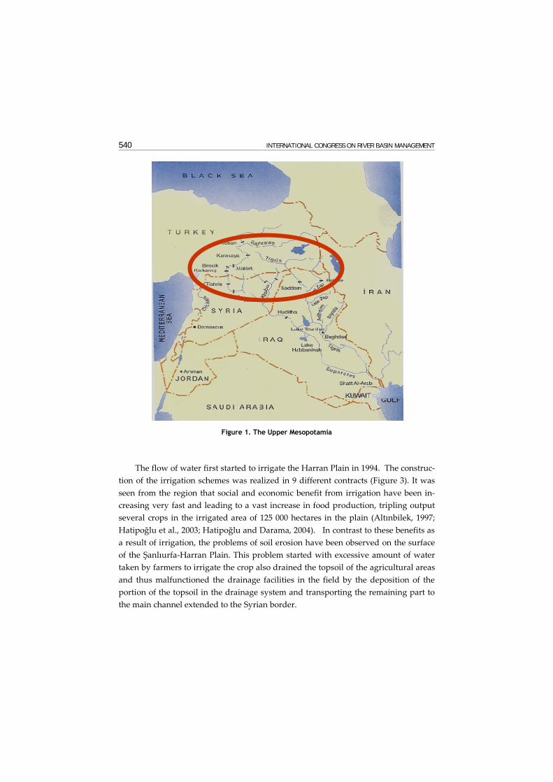
The Southeastern Anatolian Region is a part of the Upper Mesopotamia located between the Euphrates and the Tigris rivers (Fig 1) and this area known as the cradle of the ancient Mesopotamian Civilizations. Remnants of those ancient civilizations showed that intensive agricultural activities took place on the fertile and productive lands located between those rivers. Nowadays, the lands of the Upper Mesopotamia are subject to severe agricultural activities as the population has been increasing. Since the construction of the large reservoirs on the Euphrates and the Tigris rivers in Southeastern Anatolia known as GAP and other necessary infrastructure to regulate the rivers for providing sustainable water to downstream even in the driest periods, and also obtaining the most benefits for the prosperity of the people, 15 % of Tur-key’s economically viable hydropower has been produced annually and 12 % of the total irrigable area which is 1.82 million ha in the GAP region, has been in operation.
Within the context of one sub-project of the GAP project, (i.e. the Lower Euphra-tes Project), water from the Atatürk Dam reservoir is diverted to the Şanlıurfa-Harran Plains, through the Şanlıurfa Tunnel System designed (Figure 2) and con-structed for discharging 328 m3/s to irrigate 476 000 hectares of land (Hatipoğlu et al. , 2003) by gravity. The Şanlıurfa Tunnel system consisting of two parallel tunnels each 26.5 km long and 7.62 m in diameter, terminate with the Şanlıurfa Main Chan-nel near the city of Şanlıurfa. This main conveyance channel runs 4 km after the tun-nels outlet and then divided into two channels, one of which transports 124 m3/s to irrigate 150 000 hectares of land in the Şanlıurfa and Harran Plain by gravity.
540 INTERNATIONAL CONGRESS ON RIVER BASIN MANAGEMENT
Figure 1. The Upper Mesopotamia
The flow of water first started to irrigate the Harran Plain in 1994. The construc-tion of the irrigation schemes was realized in 9 different contracts (Figure 3). It was seen from the region that social and economic benefit from irrigation have been in-creasing very fast and leading to a vast increase in food production, tripling output several crops in the irrigated area of 125 000 hectares in the plain (Altınbilek, 1997; Hatipoğlu et al., 2003; Hatipoğlu and Darama, 2004). In contrast to these benefits as a result of irrigation, the problems of soil erosion have been observed on the surface of the Şanlıurfa-Harran Plain. This problem started with excessive amount of water taken by farmers to irrigate the crop also drained the topsoil of the agricultural areas and thus malfunctioned the drainage facilities in the field by the deposition of the portion of the topsoil in the drainage system and transporting the remaining part to the main channel extended to the Syrian border.

BASIN WATER MANAGEMENT 541
Figure 2. Location of the study area in GAP region (Hatipoğlu et al., 2003)
Figure 3. Harran plain irrigation schemes (Hatipoğlu et al., 2003)
In order to investigate these problems in the field, a research team was sent to the project site in 1997. Based on the observation and suggestion of this research team, intensive field study on determining the amount of sediment transported in the drainage channels at the project site was started by the staff of DSI 15th Regional Directorate in Sanlıurfa. This study focuses on the findings of the works conducted in the field between 1997 and 2002.
Ataturk Dam
Şanlıurfa Tunnels
Şanlıurfa-Harran Plain
SYRIA
542 INTERNATIONAL CONGRESS ON RIVER BASIN MANAGEMENT
2. Studies in the Project Site
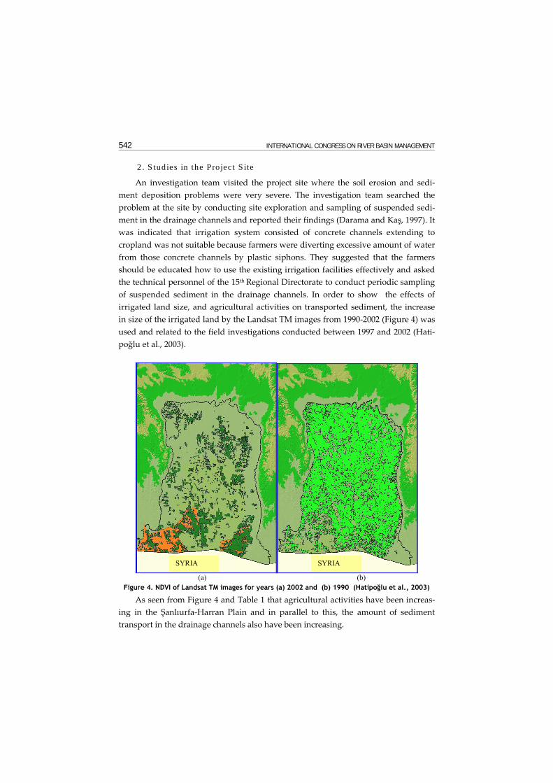
An investigation team visited the project site where the soil erosion and sedi-ment deposition problems were very severe. The investigation team searched the problem at the site by conducting site exploration and sampling of suspended sedi-ment in the drainage channels and reported their findings (Darama and Kaş, 1997). It was indicated that irrigation system consisted of concrete channels extending to cropland was not suitable because farmers were diverting excessive amount of water from those concrete channels by plastic siphons. They suggested that the farmers should be educated how to use the existing irrigation facilities effectively and asked the technical personnel of the 15th Regional Directorate to conduct periodic sampling of suspended sediment in the drainage channels. In order to show the effects of irrigated land size, and agricultural activities on transported sediment, the increase in size of the irrigated land by the Landsat TM images from 1990-2002 (Figure 4) was used and related to the field investigations conducted between 1997 and 2002 (Hati-poğlu et al., 2003).
(a) (b)
Figure 4. NDVI of Landsat TM images for years (a) 2002 and (b) 1990 (Hatipoğlu et al., 2003)
As seen from Figure 4 and Table 1 that agricultural activities have been increas-ing in the Şanlıurfa-Harran Plain and in parallel to this, the amount of sediment transport in the drainage channels also have been increasing.
SYRIA SYRIA
BASIN WATER MANAGEMENT 543
Table 1. Irrigated areas in the Şanlıurfa-Harran Plains between 1990 and 2002 (Hatipoğlu et al., 2003)
Year Irrigated Area (ha)
1990 29 950
1991 31 050
1996 37 100
2000 92 100
2001 102 510
2003 106 100
Table 1 shows that irrigation took place in the Sanliurfa-Harran Plain almost tri-
pled in size between 1996 and 2002 during which soil erosion problems in the project site was also observed.
2.1. Sampling of Suspended Sediment
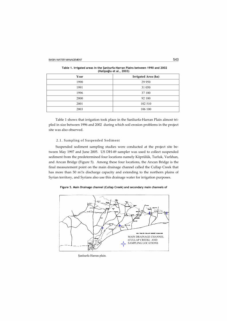
Suspended sediment sampling studies were conducted at the project site be-tween May 1997 and June 2005. US DH-49 sampler was used to collect suspended sediment from the predetermined four locations namely Köprülük, Turluk, Varlıhan, and Arıcan Bridge (Figure 5). Among these four locations, the Arıcan Bridge is the final measurement point on the main drainage channel called the Cullap Creek that has more than 50 m3/s discharge capacity and extending to the northern plains of Syrian territory, and Syrians also use this drainage water for irrigation purposes.
Figure 5. Main Drainage channel (Cullap Creek) and secondary main channels of
MAIN DRAINAGE CHANNEL (CULLAP CREEK) AND SAMPLING LOCATIONS
Şanlıurfa-Harran plain.
544 INTERNATIONAL CONGRESS ON RIVER BASIN MANAGEMENT
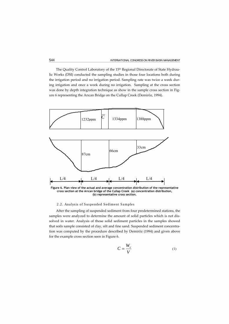
The Quality Control Laboratory of the 15th Regional Directorate of State Hydrau-lic Works (DSI) conducted the sampling studies in those four locations both during the irrigation period and no irrigation period. Sampling rate was twice a week dur-ing irrigation and once a week during no irrigation. Sampling at the cross section was done by depth integration technique as show in the sample cross section in Fig-ure 6 representing the Arıcan Bridge on the Cullap Creek (Demiröz, 1994).
87cm 66cm
33cm
L/4 L/4 L/4 L/4
1232ppm 1334ppm 1388ppmC
Figure 6. Plan view of the actual and average concentration distribution of the representative
cross section at the Arıcan bridge of the Cullap Creek (a) concentration distribution, (b) representative cross section.
2.2. Analysis of Suspended Sediment Samples
After the sampling of suspended sediment from four predetermined stations, the samples were analyzed to determine the amount of solid particles which is not dis-solved in water. Analysis of those solid sediment particles in the samples showed that soils sample consisted of clay, silt and fine sand. Suspended sediment concentra-tion was computed by the procedure described by Demiröz (1994) and given above for the example cross section seen in Figure 6.
VWC s= (1)

BASIN WATER MANAGEMENT 545
in which, Ws is the dry weight of the sediment in the sample, and V is the vol-ume of the sample. Concentration value seen in Figure 6 was computed by equation (1) and samples taken on May 27, 1997. At sampling day, the dry weight of the sedi-ment sample was 0.492 gr, and the volume of sample comprised of sediment and water was 400 cm3. Substituting these values in equation (1), one can compute C as 0.001232 gr/cm3 = 1232 ppm. Similar computations were done for the other two
depths, and the average concentration, C , for the cross section was computed from,
3
321 CCCC ++= (2)
in which, C1, C2, and C3 are the depth integrated concentration values at the ver-
tical depths in Figure 6. Substituting the computed concentration values in equation
(2), one can compute C = 1318 ppm = 1.318 kg/m3 and the total amount of sediment transported per day can be computed as CQWTS ∗= (3)
in which, Q is the total flow rate in the channel. Since the total flow rate on
sampling day was 4.739 m3/s, total amount of sediment transported, was computed as WTS = 539.7 tan/day. The computational procedure described above was per-formed for all the samples taken in the field between May 1997 and June 2005, and the result are presented in Table 2.
Table 2. Computed sediment discharge at the Arıcan Bridge station on the Cullap Creek
Year Sediment Transport Rate (ton/day)
1997 655.45 1998 740.30 1999 750.72 2000 782.59 2001 338.78 2002 880.79 2003 128.4 2004 660.10 2005 243.34
In this table the values for 1997, 1998, 1999 and 2000 are based on measurement done in 9 months, for 2001 is based on 12 months measurements and for 2002 is

546 INTERNATIONAL CONGRESS ON RIVER BASIN MANAGEMENT
based on 12 months, 2003 is based on 11 months, 2004 is based on 10 months and 2005 is based on 4 months measurements. The reason for low value of 2003 compared to the other years is because the duration of sampling was longer and the major por-tion of measurements might be performed during non irrigation period, thus the amount of transported sediment was lower in this year.
It was also determined from the analysis of the sampling charts that at the cross sections of the main drainage channel where the sampling was conducted, as the flow rates (Q) of the drainage channel increased the suspended sediment concentra-tions (C) also increased. It was observed and also stated that due to the excessive amount of water withdrawn from the irrigation canals to irrigate the crop in the field, increased the flow velocities in the farmer’s furrows. These high flow velocities in the field and in the drainage canals eroded the fertile topsoil in the field as well as transported the accumulated sediment in the unlined tertiary drainage ditches.
In order to show the salinity of the sample taken from the Arıcan Bridge cross section schematically shown in Fig. 6, the unit weight of the water sample should be computed. This can be done by
V
WW s−=γ (4)
In which, γ is the unit weight of the sample water, W is the total weight of the sample. Substituting the value of the weight of the sample and the dry weight of the sediment on that day, the unit weight of the water computed as γ = 1013.6 kg/m3. This value indicates that water sample contains some dissolved ions such as salt. This is an indication that salinity problem also existed in the plain because of ineffec-tive drainage.
2.3. Salinity Analysis with GIS
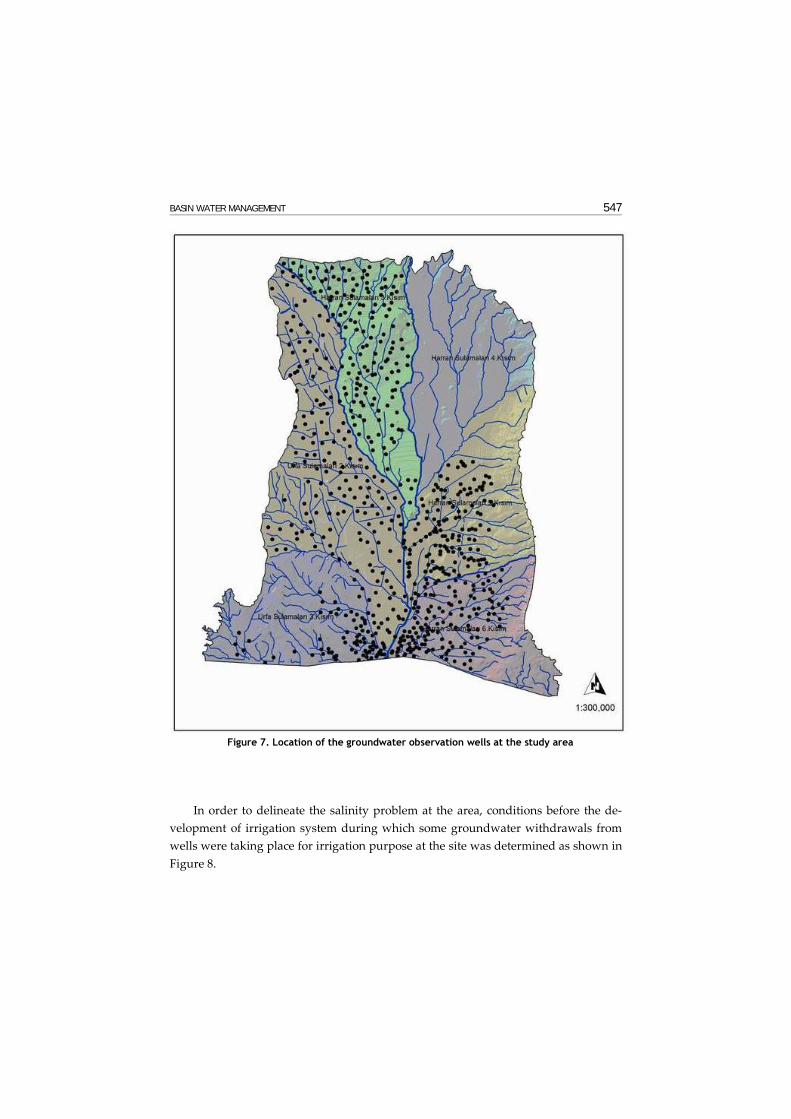
As indicated above, analysis of water samples taken from the sampling process at the site showed that salinity problems may exist at the site. In order to investigate this problem, groundwater levels at the observation wells shown in Figure 7 were measured during the irrigation periods to determine the effectives of the drainage system. Measured groundwater elevations at those wells covered the irrigation pe-riod between the year 2002 and 2004 and the results were evaluated and presented by using GIS.
BASIN WATER MANAGEMENT 547
Figure 7. Location of the groundwater observation wells at the study area
In order to delineate the salinity problem at the area, conditions before the de-velopment of irrigation system during which some groundwater withdrawals from wells were taking place for irrigation purpose at the site was determined as shown in Figure 8.

548 INTERNATIONAL CONGRESS ON RIVER BASIN MANAGEMENT
Figure 8. Salinity in the area before the development of irrigation scheme.
Figure 8 shows that even before the development of irrigation scheme at the Sanliurfa-Harran Plain, salinity existed at the south central portion of the area as shown with darker color in Figure 8. Thus it was necessary to determine whether the salinity problem expanded in the area due to ineffective irrigation and drainage system at the site.
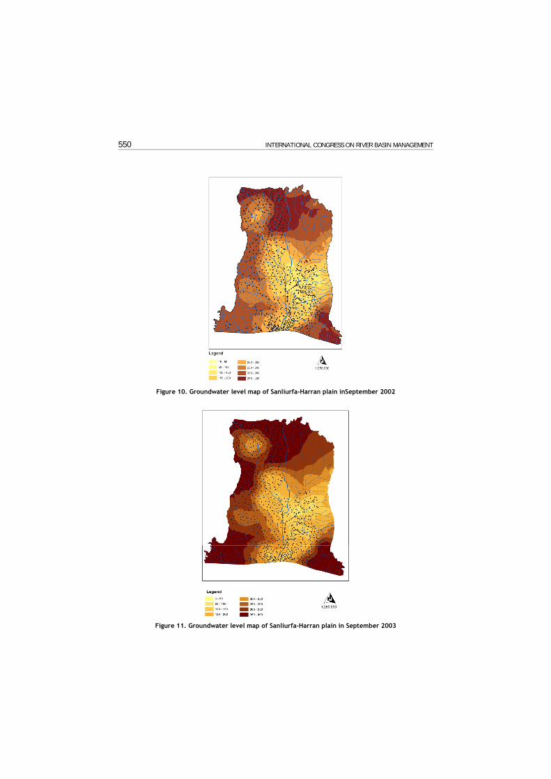
It is stated above that measured groundwater levels from the observation wells between year 2002 and 2004 during which the salinity problem was observed se-verely at the area (See Figure 9), were evaluated and graphically presented by using GIS as shown in Figures 10, 11, and 12. It can be seen from these figures that irrigat-ing the area by surface flooding not only filled the drainage canals with sediment and preventing the area from efficient drainage, but also increased groundwater levels. In these figures light colored areas shows where groundwater level is close to soil surface and it can be seen that as the surface irrigation continued during the irrigation period of 2002, 2003 and 2004, groundwater level in the area raised by the infiltration of excess irrigation water during those periods. Combination of this con-dition with insufficient drainage system of the area caused high evaporation and thus increased the salinity problem. Examination of Figures 10 to 12 reveals that major portion of the area is susceptible to salinity due to problems mentioned above.

BASIN WATER MANAGEMENT 549
Figure 9. Salinity problem determined at the study area
550 INTERNATIONAL CONGRESS ON RIVER BASIN MANAGEMENT
Figure 10. Groundwater level map of Sanliurfa-Harran plain inSeptember 2002
Figure 11. Groundwater level map of Sanliurfa-Harran plain in September 2003

BASIN WATER MANAGEMENT 551
Figure 12. Groundwater level map of Sanliurfa-Harran plain in September 2004
In order to determine which areas are more susceptible to salinity problem, in-formation for the crop pattern and maximum rooting depth of this crop was needed. According to the information obtained from DSI Investigation and Planning De-partment, for the past few years more than 85 percent of the area has been planted with cotton of which the crop maximum rooting depth is 120 cm. Furthermore, cot-ton requires much water during germination, growing and maturity period. Thus, the areas where groundwater levels are at this depth are assumed to be more suscep-tible to salinity. Using GIS the critical zone where groundwater level intersects with this rooting depth level was determined and the result is presented in Figure 13. This figure shows the area where groundwater level intersects the rooting depth of the crop and this condition causes the salinity. Result of the study of Özer and Demirel (2004) based on the studies of DSİ on site categorization and drainage prob-lems related to salinity, showed that areas shown in Figure 14 where salinity was determined. Comparison of Figure 14 with Figures 8 and 13 shows that the salinity problem in the Sanliurfa-Harran Plain is increasing due to insufficient drainage and the uncontrolled usage of irrigation return water at these areas.

552 INTERNATIONAL CONGRESS ON RIVER BASIN MANAGEMENT
Figure 13. Critical zone where groundwater level above 120 cm.
Figure 14. Salinity in the area after the development of irrigation scheme
(Özer and Demirel, 2004)

BASIN WATER MANAGEMENT 553
3. CONCLUSIONS
A study was done to determine the amount of sediment transported by the main irrigation drainage channel of the Şanlıurfa-Harran Plain since the operation of the Şanlıurfa tunnels diverted irrigation water from the Atatürk Dam. It was determined from the field investigations that this problem of erosion started with excessive amount of water supplied by farmers to irrigate the crop. This excessive amount of irrigation water by surface flooding also drained the top soil of the agricultural areas and thus malfunctioned the drainage facilities in the field by the deposition of the portion of the topsoil in the drainage system while transporting the remaining part to the main channel extended to the Syrian border. To investigate the problem at the site, detailed field surveys launched and suspended sediment measurements have been performed at the main drainage channels of the Şanlıurfa-Harran Plain. Analy-sis of those measurements showed that the yearly averaged sediment washed by the excessive amount of irrigation water from the soil surface of Şanlıurfa-Harran Plain and transported to Syria is about 670 tons/day. Analysis of the samples as well as investigations at the area also showed that salinity problem existed in the field as a result of inappropriate drainage system management and maintenance and this problem resulted in deposition of the portion of the fine sediment in the secondary drainage channels. Analysis of groundwater levels at the study area by using GIS together with the crop pattern rooting depth showed present irrigation practice in the area with inappropriate drainage system management and maintenance at southern part of the area increased the salinity at the site. Analysis of groundwater level data by using GIS also showed that if the present irrigation and drainage prac-tice continues the major portion of the area is susceptible to salinity problem.
REFERENCES Altınbilek, H.D. (1997). Water and Land Resources Development in Southeastern Turkey, Water
Resources Development, Volume 13, No: 3, pp. 311-332. Hatipoğlu, M. and Darama, Y. (2004). Hydro Schemes in Southeastern Anatolian Project (GAP),
Submitted to 6th International Congress on Advances in Civil Engineering, 6-8 October, Boga-zici University, Istanbul, Turkey
Darama, Y., Kaş, İ. (1997). Investigation of the Sediment Amount in the Secondary and Main Drainage Channels of Şanlıurfa-Harran Plain Irrigation System. Technical Report Publication No: HI-917, DSI, Technical Research and Quality Control Department, Ankara, Turkey (In Turkish)
Demiröz, E. (1994). Measurement of Sediment Load, Proceedings of Post Graduate Course in Sediment Transport Technology, Volume 2., page 13.1-13.48, Ankara, Turkey.
Hatipoğlu, M., K. Seyrek, and B. Boz. (2003). Monitoring of Irrigation Development in Şanlıurfa-Harran Plain Using Remote Sensing and Geographic Information Systems, Proceedings of the International Colloquium Series on Land Use/Cover Science and Applications on Studying Land Use Effects in Coastal Zones with Remote Sensing and GIS, pp. 394-404, August 13-16, Kemer-Antalya, Turkey.
Özer, N, and A.F. Demirel, 2004, Groundwater Level and Salinity Problems During the Operation Period of the Sanliurfa-Harran Plain, Research Report, DSI Investigation & Planning Dept.