programme (pep) 2021 prelims exclusive iasbaba's
TRANSCRIPT

IASBABA'SPRELIMS EXCLUSIVE
PROGRAMME (PEP) 2021
GEOGRAPHY DAILY TESTS
IASbaba’s Prelims Exclusive Program (PEP) Geography Test – 10 Solutions
2021
www.iasbaba.com Contact: 91691 91888 Page 1
Q.1) Solution (b) Statement Analysis:
Statement 1 Statement 2
Incorrect Correct
As per World Steel Association data, India became the second largest steel producer of crude steel after China in 2018 and 2019, by replacing Japan. India’s crude steel production in 2018 was 109.3 MT (increase of 7.7% from 101.5 MT in 2017).
Steel being a deregulated sector, the Government does not set any annual targets for steel production
Q.2) Solution (a) Basic Information: Coal is the most important and abundant fossil fuel in India. It accounts for 55% of the country's energy needs. The country's industrial heritage was built upon indigenous coal. Commercial primary energy consumption in India has grown by about 700% in the last four
decades. The current per capita commercial primary energy consumption in India is about 350
kgoe/year which is well below that of developed countries. Driven by the rising population, expanding economy and a quest for improved quality of
life, energy usage in India is expected to rise. Statement Analysis:
Statement 1 Statement 2 Statement 3
Correct Incorrect Incorrect
Coal is the most important and abundant fossil fuel in India. It accounts for 55% of the country's energy needs.
Top 5 States in terms of total coal reserves in India are: Jharkhand > Odisha > Chhattisgarh > West Bengal > Madhya Pradesh.
Recently India opened its coal sector for private players. India will now offer coal mines to private companies ‘only for commercial mining and sale purpose’, thereby moving away from the earlier regime of offering mines for captive use.
Q.3) Solution (d) Basic Information: As of January 2020, the total installed wind power capacity in India was 37.607 GW. India has the 4th largest installed capacity in wind power after China, U.S and Germany. India has high wind energy potential — 302 GW at 100 metres hub height and 695 GW at
120 metres according to National Institute of Wind Energy (NIWE).

IASbaba’s Prelims Exclusive Program (PEP) Geography Test – 10 Solutions
2021
www.iasbaba.com Contact: 91691 91888 Page 2
Tamil Nadu has the highest wind energy capacity followed by Gujarat, Maharashtra, Karnataka, Rajasthan and Andhra Pradesh.
In 2015, India announced an ambitious goal of installing 60 GW of wind energy by December 2022.
Wind energy sector in India is facing a grim future. Due to the stagnation in its very promising growth trajectory, the sector has virtually come to a standstill, with an annual installation of less than 1,500 MW in 2018.
Statement Analysis:
Statement 1 Statement 2
Incorrect Incorrect
India has the 4th largest installed capacity in wind power after China, U.S and Germany.
Tamil Nadu has the highest wind energy capacity followed by Gujarat, Maharashtra, Karnataka, Rajasthan and Andhra Pradesh.
Q.4) Solution (a) Basic Information: As per The National Waterways Act, 2016, 111 waterways have been declared as National Waterways (NWs) including the five existing NWs. Out of the 111 NWs, NW-1, 2, & 3 are already operational. Cargo, as well as passenger/cruise vessels, are plying on these waterways. List of national waterways:
National Waterways
Approximate Length (Km.)
State
National Waterway-1
1620 UP, Bihar, Jharkhand, West Bengal
National Waterway-2
891 Assam
National Waterway-3
365 Kerala
National Waterway-4
2890 Tamil Nadu, Andhra Pradesh, Telangana
National Waterway-5
588 Odisha, West Bengal
Q.5) Solution (c) Basic Information: The service sector activities can be divided into quaternary and quinary activities. Quaternary activities involve some of the following: the collection, production and

IASbaba’s Prelims Exclusive Program (PEP) Geography Test – 10 Solutions
2021
www.iasbaba.com Contact: 91691 91888 Page 3
dissemination of information or even the production of information. The Quaternary Sector along with the Tertiary Sector has replaced most of the primary and
secondary employment as the basis for economic growth. There are broadly four types of job. These are primary, secondary, tertiary and quaternary jobs.
Primary jobs involve getting raw materials from the natural environment e.g. Mining, farming and fishing.
Secondary jobs involve making things (manufacturing) e.g. making cars and steel. · Tertiary jobs involve providing a service e.g. teaching and nursing.
Quaternary jobs involve research and development. Q.6) Solution (d) Basic Information: The Atlantic Ocean is the second largest Ocean in the world. The coastline of Atlantic Ocean is highly indented. This irregular and indented coastline
provides ideal location for natural harbours and ports. From the point of view of commerce, it is the busiest Ocean.
Thriving Atlantic Rim economies is not related to the Natural harbours and ports. Atlantic Ocean is 'S' shaped. It is flanked by the North and South Americas on the western
side, and Europe and Africa on the eastern side Q.7) Solution (c) Basic Information: Kochchi Port, situated at the head of Vembanad Kayal, popularly known as the 'Queen of
the Arabian Sea', is also a natural harbour. This port has an advantageous location being close to the Suez-Colombo route. It caters to the needs of Kerala, southern-Karnataka and south western Tamil Nadu
Q.8) Solution (c) Basic Information: Industrial regions emerge when a number of industries locate close to each other and share the benefits of their closeness. They tend to concentrate on certain locations because of the favourable locational factors. India has several industrial regions like Mumbai- Pune cluster, Bangalore-Tamil Nadu
region, Hugli region, Ahmedabad-Baroda region, Chottanagpur industrial belt, Vishakhapatnam-Guntur belt, Gurgaon-Delhi-Meerut region and the Kollam Thiruvanathapuram industrial cluster.

IASbaba’s Prelims Exclusive Program (PEP) Geography Test – 10 Solutions
2021
www.iasbaba.com Contact: 91691 91888 Page 4
Q.9) Solution (a) Basic Information: Nomadic herding is a primitive form of subsistence activity. Here, cattles are used by herders for tools, transport, food and clothing. Different tribes moves with cattles in search of pastures both horizontally (across latitude) and vertically (across elevation) in search of pastures. Moving of tribes up the mountain during summers for pastures and subsequently coming
back to plains during winters is called as Transhumance. In tundra region, tribes moves from South to north in summers and north to south in
winters. In India Gaddis, Gujjars, Bakarwal and Bhotiyas in himalayan region are the nomadic
herding tribes who practice transhumance. Masai tribes of Nigeria, Their main activity was raising cattle, but the Maasai have also
been known for centuries as fearsome hunters and warriors. By the mid-19th century Maasai territory was at its largest, extending over pretty much the entirety of modern-day Kenya and half of Tanzania.
Q.10) Solution (a) Basic Information: Aman, Aus and Boro are rice varieties. Rice is usually sown thrice. Aman: This variety is sown in the rainy season (July-August) and harvested in winter. This is
mainly produced. Aus: Rice sown in summer along with the pre-monsoonal showers and harvested in
autumn. The quality of this rice is rough. Boro: Rice sown in winter and harvested in summer. This is also called spring rice. Q.11) Solution (d)

IASbaba’s Prelims Exclusive Program (PEP) Geography Test – 10 Solutions
2021
www.iasbaba.com Contact: 91691 91888 Page 5
Basic Information: It can be grown on a variety of soils, but alluvial clayey loam of the Indo-Gangetic plains are ideal for its growth. It is also grown in black soil in the South. It can grow in any type of soil as long as the soil can retain moisture. The soil should be rich in nitrogen, calcium and phosphorous. Sugarcane is a tropical plant, therefore, requires a year warm weather to reach maturity.
The areas having temperature of 20° to 26°C and an average rainfall of 75-100 cm are suitable for its cultivation.
Q.12) Solution (d) Basic Information: The major copper mines are the Khetri, Alwar copper belt in Rajasthan, Singhbhum copper belt in Jharkhand and Malanjkhand copper belt in Madhya Pradesh which are mined by HCL; Singhbhum belt is mined by M/s Indian Copper Complex. Q.13) Solution (a) Basic Information: Nonmetallic minerals are a special group of chemical elements from which no new product can be generated if they are melted. Nonmetallic minerals are, for example, sand, gravel, limestone, clay, and marble. The nonmetallic minerals industry is best known for the production of cement, ceramics,
glass, and lime products. Q.14) Solution (c) Basic Information: Dryland Farming is largely confined to the regions having annual rainfall less than 75 cms. These regions grow hardy and drought resistant crops such as ragi, bajra, moong, gram and guar (fodder crops) and practice various measures of soil moisture conservation and rain water harvesting Q.15) Solution (d) Basic Information: Sugarcane is a labour intensive crop. The crop is kept weed-free and irrigated frequently if there are no timely rain. Most of the crop is planted just before the hot season, a little earlier in the southern and eastern parts. Sugarcane is planted through following methods: Sett Method: New canes are usually planted by taking cuttings from old plants. These
cuttings, known as setts, quickly become established and after a few days buds sprout to form new stalks. Four to five stalks grow from cutting. The sugarcane takes anything from 8 months to a year to mature.
Ratooning: In this method, during the first harvest, the sugarcane is cut leaving a little bit of the stalk in the soil with the roots. The stalk soon puts out new shoots or ratoons. The second or any other successive crop obtained from the roots of the leftover crop is called
IASbaba’s Prelims Exclusive Program (PEP) Geography Test – 10 Solutions
2021
www.iasbaba.com Contact: 91691 91888 Page 6
Ratoon. Q.16) Solution (b) Statement Analysis:
Statement 1 Statement 2 Statement 3
Correct Correct Incorrect
Rocks of Vindhyan system are important source of building materials such as limestone, dolomite, marble etc.
Rocks of Gondwana system are source of 98% coal found in India. For eg: chotanagpur plateau
Rocks of Dharwar system are the oldest sedimentary rocks and important source of metallic minerals such as Iron, Gold and Manganese etc. Eg: Bellary Iron ore mines
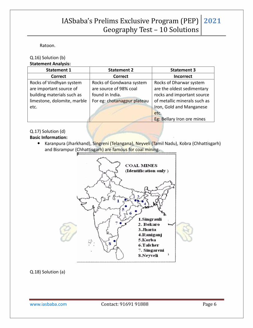
Q.17) Solution (d) Basic Information:
Karanpura (Jharkhand), Singreni (Telangana), Neyveli (Tamil Nadu), Kobra (Chhattisgarh) and Bisrampur (Chhattisgarh) are famous for coal mining.
Q.18) Solution (a)
IASbaba’s Prelims Exclusive Program (PEP) Geography Test – 10 Solutions
2021
www.iasbaba.com Contact: 91691 91888 Page 7
Statement Analysis:
Statement 1 Statement 2
Correct Incorrect
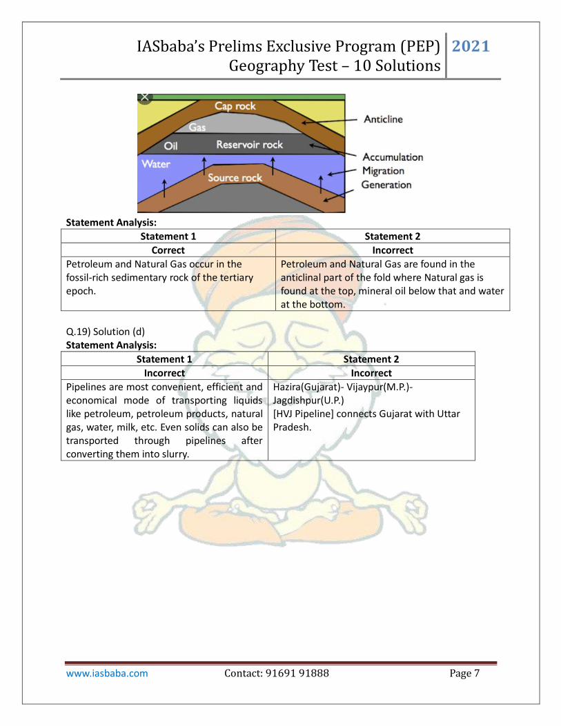
Petroleum and Natural Gas occur in the fossil-rich sedimentary rock of the tertiary epoch.
Petroleum and Natural Gas are found in the anticlinal part of the fold where Natural gas is found at the top, mineral oil below that and water at the bottom.
Q.19) Solution (d) Statement Analysis:
Statement 1 Statement 2
Incorrect Incorrect
Pipelines are most convenient, efficient and economical mode of transporting liquids like petroleum, petroleum products, natural gas, water, milk, etc. Even solids can also be transported through pipelines after converting them into slurry.
Hazira(Gujarat)- Vijaypur(M.P.)-Jagdishpur(U.P.) *HVJ Pipeline+ connects Gujarat with Uttar Pradesh.

IASbaba’s Prelims Exclusive Program (PEP) Geography Test – 10 Solutions
2021
www.iasbaba.com Contact: 91691 91888 Page 8
Q.20) Solution (d) Statement Analysis:
Statement 1 Statement 2
Incorrect Incorrect
India’s nuclear power plants contributed to less than 3% of the country’s electricity generation
Its share may further come down as other sources (Solar, wind energy) may generate more.
Q.21) Solution (d) Basic Information:
Brazil is the world’s largest exporter of coffee, and it used to be one of the largest exporters of cacao. Coffee estates in Brazil are called ‘Fazendas’ .
Rubber plantation is done in Equatorial rainforests of Amazon. Manaus in Brazil is the rubber collection center of Brazil. This is also the most inland port of the world.
Rosario and Buenos Aires have well developed slaughter houses called ‘Frigorificos’ Q.22) Solution (c) Basic Information:
IASbaba’s Prelims Exclusive Program (PEP) Geography Test – 10 Solutions
2021
www.iasbaba.com Contact: 91691 91888 Page 9
Lignite, which is also known as brown coal, is a lower grade coal. It contains about 45 to 55 per cent carbon. Lignite coal is mainly produced in two states, Tamil Nadu and Gujarat. Small lignite coal
fields are also found in Rajasthan and Jammu and Kashmir. Neyveli is the lignite field in Tamil Nadu which is located in South Arcol district. Neyveli is the largest lignite coal mine of India. This field supplies fuel for thermal power
generation in Tamil Nadu. Q.23) Solution (d) Basic Information: Thorium India has reserves of thorium in sufficient quantity as compared to other parts of world. The Atomic Minerals Directorate for Exploration and Research (AMD), a constituent unit of Department of Atomic Energy (DAE), has so far established 11.93 million tonnes of in situ resources Monazite (Thorium bearing mineral) in the country, which contains about 1.07 million tonnes of thorium Uranium and Thorium have got distinctive characteristics governing their utilisation in
nuclear reactors. Unlike uranium, thorium alone cannot be directly used as nuclear fuel in a reactor.
Utilisation of Thorium with either uranium or plutonium, without going through the second stage of Fast Breeder Reactors, to build sufficient inventory of plutonium first, will be counter- productive by limiting thorium utilisation to a very small fraction of the total available resources in the country.
Q.24) Solution (d) Basic Information:

IASbaba’s Prelims Exclusive Program (PEP) Geography Test – 10 Solutions
2021
www.iasbaba.com Contact: 91691 91888 Page 10
Q.25) Solution (c) Statement Analysis:
Statement 1 Statement 2 Statement 3
Correct Incorrect Correct
It is in Russia and it provides 11,220km navigable waterway and drains into Caspian Sea.
It connects the interior USA with Gulf of Mexico in the south.
It serves Eastern Europe. The Danube River rises in Black Forest and flows eastwards. It is navigable up to Taruna Severin.
Q.26) Solution (d) Basic Information: Pterocarpus santalinus (Red sanders) occurs in the forest formation which is classified as ”5A/C3 Southern Tropical Dry Deciduous Forests” as per Champion and Seth Classification and falls in the eco-terrestrial region IM1301 Deccan Thorn Scrub Forests and as well as IM0201 Central Deccan Plateau Dry Deciduous Forests. It is generally found at altitudes of 150 - 900 m. It grows on dry, hilly, often rocky ground,
and occasionally found on precipitous hill sides also. It prefers lateritic and gravelly soil and cannot tolerate water logging.
In natural habitat the tree experiences hot, dry climate with normal rainfall of 88-105 cm received from north-east and south-west monsoons.
Red Sanders has a highly restrictive distribution in the South Eastern portion of Indian peninsula to which it is endemic.
IASbaba’s Prelims Exclusive Program (PEP) Geography Test – 10 Solutions
2021
www.iasbaba.com Contact: 91691 91888 Page 11
The Palakonda and Seshachalam hill ranges of Cuddapah- Chittoor districts of the State of Andhra Pradesh are its principal geographical range which extends slightly into the neighbouring Anantapur, Kurnool, Prakasam and Nellore Districts of Andhra Pradesh. Sporadic wild populations occur in the adjoining districts of the neighbouring states of Tamil Nadu & Karnataka.
Red Sanders is said to be used in the making of oriental musical instruments like Shamisen, Koto and Erhu.
Q.27) Solution (d) Basic Information: Shale gas has abundant reserves around the world, which may be sufficient to meet the demand of clean energy for many years to come. Shale gas is found in unconventional reservoirs typically trapped in shale rock, having low permeability, originally deposited as clay and silt. This makes it more difficult and more expensive to extract because of high upfront costs. Shale gas is generally found at 2000 to 5000 meters below the earth’s surface unlike conventional natural gas – trapped in sandstone rock having high permeability and can be easily assessed to be produced by traditional vertical drilling, found at 1500 meters. The technique used for shale gas production requires first drilling a vertical well to the targeted rock followed by horizontal drilling exposing the well to more of producing shale. Statement Analysis:
Statement 1 Statement 2 Statement 3
Correct Correct Correct
In general gas is considered cleaner fuel than coal and oil
India has got technically recoverable shale gas of 96 trillion cubic feet. The recoverable reserves are identified in Cambay, Krishna – Godavari, Cauvery, Damodar Valley, Upper Assam, Pranahita – Godavari, Rajasthan and Vindhya Basins. The Oil and Natural Gas Corporation has drilled the first exploratory shale gas well in Jambusar near Vadodara, Gujarat, in Cambay basin during October 2013.
Hydraulic Fracturing or Fracking, is a process in which water, chemicals and sand are pumped at high pressure into the well to unlock the gas trapped in shale rocks by opening cracks or fractures in the rock and allowing gas to flow from shale into the well and onto the surface.
Q.28) Solution (b) Basic Information: Savanna Climate support a wide range of tropical crops. The newly independent states of
IASbaba’s Prelims Exclusive Program (PEP) Geography Test – 10 Solutions
2021
www.iasbaba.com Contact: 91691 91888 Page 12
Kenya, Uganda, Tanzania and Malawi have taken to large scale production of cotton. In West Africa, the commercial cultivation of ground nut, oil palm and cocoa have been extended into the savanna lands.
Climatically, tea belongs to the monsoon lands where high temperatures, long growing season and heavy rainfall help the growth of tea plants. A temperature of 21°C during the growing season of not less than eight months is ideal.
Q.29) Solution (c) Basic Information: Cotton is a "pure" raw material which does not lose weight in the manufacturing process. In iron and steel industries, iron ore and coal both are weight-losing raw materials. In sugar
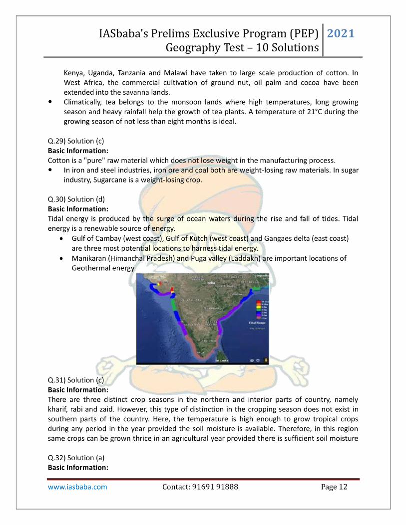
industry, Sugarcane is a weight-losing crop. Q.30) Solution (d) Basic Information: Tidal energy is produced by the surge of ocean waters during the rise and fall of tides. Tidal energy is a renewable source of energy.
Gulf of Cambay (west coast), Gulf of Kutch (west coast) and Gangaes delta (east coast) are three most potential locations to harness tidal energy.
Manikaran (Himanchal Pradesh) and Puga valley (Laddakh) are important locations of Geothermal energy.
Q.31) Solution (c) Basic Information: There are three distinct crop seasons in the northern and interior parts of country, namely kharif, rabi and zaid. However, this type of distinction in the cropping season does not exist in southern parts of the country. Here, the temperature is high enough to grow tropical crops during any period in the year provided the soil moisture is available. Therefore, in this region same crops can be grown thrice in an agricultural year provided there is sufficient soil moisture Q.32) Solution (a) Basic Information:
IASbaba’s Prelims Exclusive Program (PEP) Geography Test – 10 Solutions
2021
www.iasbaba.com Contact: 91691 91888 Page 13
Population ageing is a process by which the population of older people become proportionally higher: Statement Analysis:
Statement 1 Statement 2 Statement 3
Incorrect Incorrect Correct
population ageing is accompanied with low birth rate and low death rate
population ageing is not associated with Sex ratio
low birth rate leads to a condition where working population decreases and low death rate ensures that population of dependent older people increases
Q.33) Solution (d) Statement Analysis:
Statement 1 Statement 2 Statement 3
Correct Correct Correct
Dairy farming is both highly capital intensive as well as labour intensive. It involves capital investments in farm machinery, buildings, milk processing equipment etc. Labour is required to take proper care of animals
There is no off season during the year as in the case of crop raising.
Dairy products have a very short shelf life. So, nearby markets are an important requirement for the dairy farms to gain profits
Q.34) Solution (c) Basic Information: Mixed farming is a type of farming which involves both the growing of crops and the raising of livestock. This type of farming is practiced across Asia and in countries such as India, Malaysia, Indonesia, Afghanistan, South Africa, China, Central Europe, Canada, and Russia. Statement Analysis:
Statement 1 Statement 2
Correct Correct
To maintain the soil fertility, farmers practice crop rotation and inter cropping.
Mixed farming is found in the developed countries of North Western Europe, Eastern North America, parts of Eurasia and temperate latitudes of South America and Australia.
Q.35) Solution (d) Basic Information:
IASbaba’s Prelims Exclusive Program (PEP) Geography Test – 10 Solutions
2021
www.iasbaba.com Contact: 91691 91888 Page 14
There are various factors and conditions responsible for having different types of rural settlements in India. These include: 1. Physical features – nature of terrain, altitude, climate and availability of water. 2. Cultural and ethenic factors – social structure, caste and religion. 3. Security factors – defence against thefts and robberies. Clustered Settlements: Such settlements are generally found in fertile alluvial plains and in
the northeastern states. Sometimes, people live in compact village for security or defence reasons, such as in the Bundelkhand region of central India and in Nagaland.
Hameleted settlement: This segmentation of a large village is often motivated by social and ethnic factors. Such villages are more frequently found in the middle and lower Ganga plain, Chhattisgarh and lower valleys of the Himalayas.
Dispersed settlement: Extreme dispersion of settlement is often caused by extremely fragmented nature of the terrain and land resource base of habitable areas. Many areas of Meghalaya, Uttaranchal, Himachal Pradesh and Kerala have this type of settlement.
Q.36) Solution (c) Statement Analysis:
Statement 1 Statement 2 Statement 3
Incorrect Correct Correct
Brazil is largest producer of suger in the world. However, India is the largest producer of sugar including traditional cane sugar sweeteners, khandsari and Gur equivalent followed by Brazil.
Broadly, there are two distinct agro-climatic regions of sugarcane cultivation in India, viz., tropical and subtropical.
In India, the pricing of sugarcane is governed by the statutory provisions of the Sugarcane (Control) Order, 1966 issued under the Essential Commodities Act (ECA), 1955
Q.37) Solution (d) Basic Information: Fishes eat plankton. Phytoplankton require sunlight. They can develop well in continental shelves and shallow seas because of Sunlight penetration and minerals from coastal water. Planktons reproduce more in cooler waters Statement Analysis:
Statement 1 Statement 2 Statement 3 Statement 4
Correct Correct Correct Correct
The existence of extensive irregular coastline has favoured the
This region has extensive and shallow continental shelf that has
The convergence of the Warm and Cold currents has supported the
Upwelling of waters bring nutrient from sea bed which is important for

IASbaba’s Prelims Exclusive Program (PEP) Geography Test – 10 Solutions
2021
www.iasbaba.com Contact: 91691 91888 Page 15
development of fishing ports, occurrence of breeding places for fish due to the sheltered waters
supported the growth of enough plankton. This is so, because light can reach the sea beds.
creation of favourable conditions that give a hand to the growth of plankton and fish metabolism.
plankton as well as fishes
Q.38) Solution (b) Basic Information:
Water Source Percent of Total Water
Oceans, Seas and Bays 97.25
Ice caps and Glaciers 2.05
Groundwater 0.68
Lakes 0.01
Swamps 0.008
Soil Moisture 0.005
Atmosphere 0.001
Rivers and streams 0.0001
Biosphere 0.00004
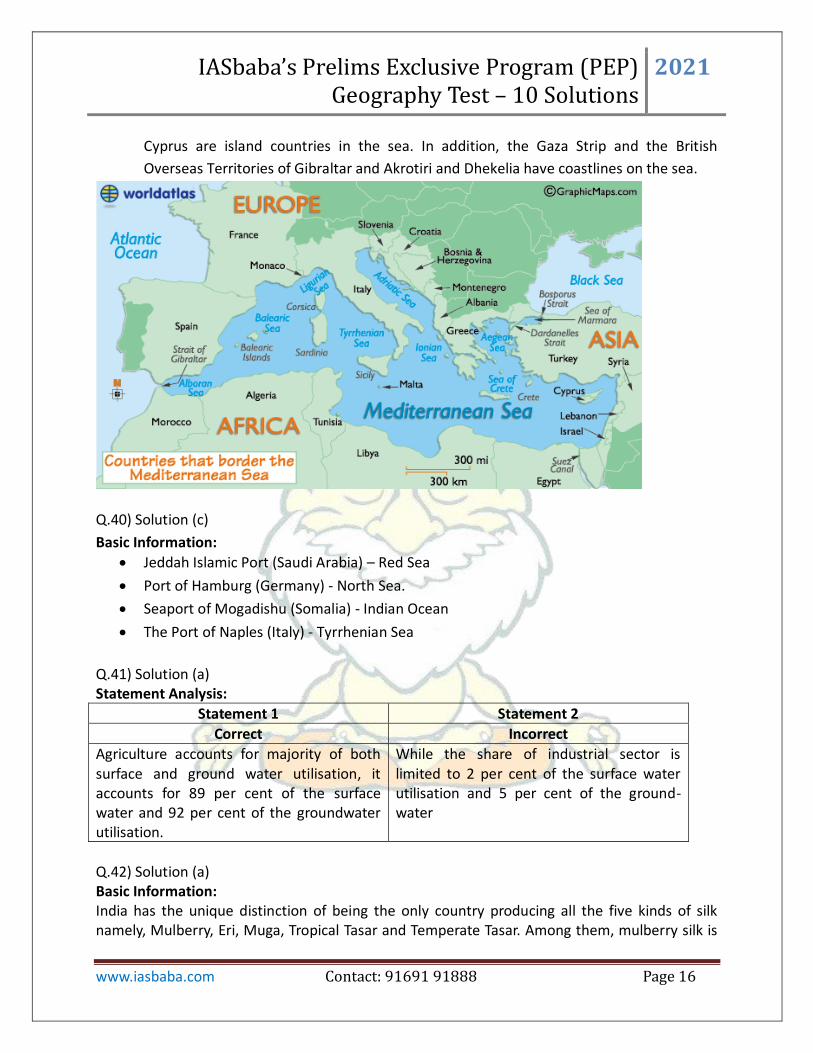
Q.39) Solution (d) Basic Information:
The Mediterranean Sea is a sea connected to the Atlantic Ocean, surrounded by the
Mediterranean Basin and almost completely enclosed by land: on the north by Southern
Europe and Anatolia, on the south by North Africa, and on the east by the Levant.
The countries surrounding the Mediterranean in clockwise order are Spain, France,
Monaco, Italy, Slovenia, Croatia, Bosnia and Herzegovina, Montenegro, Albania, Greece,
Turkey, Syria, Lebanon, Israel, Egypt, Libya, Tunisia, Algeria, and Morocco; Malta and
IASbaba’s Prelims Exclusive Program (PEP) Geography Test – 10 Solutions
2021
www.iasbaba.com Contact: 91691 91888 Page 16
Cyprus are island countries in the sea. In addition, the Gaza Strip and the British
Overseas Territories of Gibraltar and Akrotiri and Dhekelia have coastlines on the sea.
Q.40) Solution (c)
Basic Information:
Jeddah Islamic Port (Saudi Arabia) – Red Sea
Port of Hamburg (Germany) - North Sea.
Seaport of Mogadishu (Somalia) - Indian Ocean
The Port of Naples (Italy) - Tyrrhenian Sea
Q.41) Solution (a) Statement Analysis:
Statement 1 Statement 2
Correct Incorrect
Agriculture accounts for majority of both surface and ground water utilisation, it accounts for 89 per cent of the surface water and 92 per cent of the groundwater utilisation.
While the share of industrial sector is limited to 2 per cent of the surface water utilisation and 5 per cent of the ground-water
Q.42) Solution (a) Basic Information: India has the unique distinction of being the only country producing all the five kinds of silk namely, Mulberry, Eri, Muga, Tropical Tasar and Temperate Tasar. Among them, mulberry silk is

IASbaba’s Prelims Exclusive Program (PEP) Geography Test – 10 Solutions
2021
www.iasbaba.com Contact: 91691 91888 Page 17
the most popular variety, which contributes around 79% of the country's silk production. Of the total raw silk production is provisionally at 23,679 MT in 2012-13, Mulberry accounted for 79.0% (18715 MT), Eri 13.2 % (3116 MT), Tasar 7.3% (1729 MT) and Muga 0.5% (119 MT). Q.43) Solution (b) Basic Information:
Strait Connects Separates
Bab-el-Mandeb Red Sea to Gulf of Aden Yamen (Asia) from Djibouti & Eritrea
(Africa)
Bass strait Pacific Ocean (No other
water body) Tasmania from the Australian
mainland
Bering Strait Bering Sea (Pacific Ocean) to Chukchi Sea (Arctic Ocean)
Russia from Alaska (USA)
Bosphorus Strait Black Sea to Sea of
Marmara Asian Turkey from European Turkey
Cook Strait Pacific Ocean (No other
water body) North Island from South Islands of
New Zealand
Davis strait Baffin Bay to Atlantic Ocean Greenland from Nunavut (Canada's
Baffin Island)
Denmark strait Atlantic Ocean (No other
water body) Iceland from Greenland
Dover strait English Channel & North
Sea England from France
English Channel North Sea & Atlantic Ocean England from France
Florida Strait Gulf of Mexico to Atlantic
Ocean Florida (USA) from Cuba

IASbaba’s Prelims Exclusive Program (PEP) Geography Test – 10 Solutions
2021
www.iasbaba.com Contact: 91691 91888 Page 18
Gibraltar Strait Atlantic Ocean to
Mediterranean Sea Spain (Europe) from Morocco (Africa)
Hormuz strait Gulf of Oman to Persian Gulf UAE & Oman from Iran
Hudson strait Atlantic Ocean to Hudson
Bay Baffin Island from Quebec (in
Canada)
Magellan strait Pacific Ocean to Atlantic
Ocean
Mainland South America from north and Tierra del Fuego to the south
(South America)
Malacca Strait South China Sea to
Andaman Sea Malay Peninsula from Indonesian
island
Mozambique Strait Indian Ocean (No other
water body) Madagascar from Mozambique
Palk Strait Bay of Bengal to Gulf of
Mannar India from Sri Lanka
Sunda Strait Indian Ocean to Java Sea Islands of Java from Sumatra
(Indonesia)
Torres Strait Arafura Sea to Coral Sea
(Pacific Ocean) Australia from Papua New Guinea
Tsugaru Strait Sea of Japan (East Sea) to
Pacific Ocean Honshu from Hokkaido (Japan)
Yucatan Strait Gulf of Mexico to Caribbean
Sea Mexico from Cuba
100 Channel Bay of Bengal to Andaman
Sea Island of Little Andaman from Car
Nicobar Island (of India)
90 Channel Indian Ocean (No other
water body) Laccadive Islands of Kalpeni from
Suheli Par, and Maliku Atoll (of India)

IASbaba’s Prelims Exclusive Program (PEP) Geography Test – 10 Solutions
2021
www.iasbaba.com Contact: 91691 91888 Page 19
Q.44) Solution (a) Basic Information:
Major mines Countries
Grasberg Indonesian province of Papua
Muruntau Uzbekistan
Olampiada Russia
Kibali Democratic republic of Congo
Kalgoorlie Australia
Q.45) Solution (d) Basic Information:
Lake Victoria – Kenya, Uganda and Tanzania
Lake Tanganyika – Burundi, Democratic Republic of Congo, Zambia, and Tanzania
Lake Malawi - Malawi, Mozambique and Tanzania
Q.46) Solution (a) Basic Information: Polymetallic nodules, also known as manganese nodules, are potato-shaped, largely porous nodules found in abundance carpeting the sea floor of world oceans in deep sea. Besides manganese and iron, they contain nickel, copper, cobalt, lead etc which are of economic and
IASbaba’s Prelims Exclusive Program (PEP) Geography Test – 10 Solutions
2021
www.iasbaba.com Contact: 91691 91888 Page 20
strategic importance. Formed by slow precipitation of the metallic components from seawater. This is thought to produce nodules with similar iron and manganese content and a relatively high grade of nickel, copper and cobalt. Statement Analysis:
Statement 1 Statement 2 Statement 3
Incorrect Correct Incorrect
They are found in abundance carpeting the sea floor of world oceans in deep sea.
Besides manganese and iron, they contain nickel, copper, cobalt, lead etc which are of economic and strategic importance.
Mining is regulated by international sea bed authority (ISA)
Q.47) Solution (a) Basic Information:
Rare Earth Elements are a set of 17 chemical elements in the periodic table - the 15
lanthanides, plus scandium and yttrium, which tend to occur in the same ore deposits as
the lanthanides, and have similar chemical properties.
These elements are important in technologies of consumer electronics, computers and
networks, communications, clean energy, advanced transportation, healthcare,
environmental mitigation, and national defence, among others.
Statement Analysis:
Statement 1 Statement 2 Statement 3
Correct Correct Incorrect
The rare earth elements are all metals,
and the group is often referred to as
the "rare earth metals." These metals
have many similar properties, and that
often causes them to be found together
in geologic deposits. They are also
referred to as "rare earth oxides"
because many of them are typically sold
as oxide compounds.
China has
dominated rare
earths
production for a
number of
years. In 2019,
its domestic
output was
132,000 MT.
India’s current rare earths
production industry is far below
its potential. The country holds
almost 35 percent of the world’s
total beach sand mineral
deposits, which are significant
sources of rare earths, but 2019
rare earths production in India
was just 3,000 MT.
Q.48) Solution (c) Basic Information:
Largest viable uranium deposits are found in Australia, Kazakhstan, and Canada.
The Chu-Sarysu basin in central Kazakhstan; Olympic Dam and the Ranger mine in
Southern Australia are some of important mines in world.

IASbaba’s Prelims Exclusive Program (PEP) Geography Test – 10 Solutions
2021
www.iasbaba.com Contact: 91691 91888 Page 21
Athabasca Basin, Cigar Lake, McArthur River basin in Canada are other important
uranium mining sites.
High-grade deposits of uranium are found in the Athabasca Basin region of Canada.
The Athabasca Basin is a region in the Canadian Shield of northern Saskatchewan and
Alberta, Canada. It is best known as the world's leading source of high-grade uranium
and currently supplies about 20% of the world's uranium.
Q.49) Solution (a) Basic Information:
Chile has the most lithium reserves in the world but it is the second biggest producer of
lithium. While Australia was the largest lithium-producing country in the world in 2019
and it is second in terms of reserves.
Lithium reserves: Chile > Australia > Argentina > China > USA > Canada > Zimbabwe >
Brazil > Portugal.
Lithium production: Australia > Chile > China > Argentina > Zimbabwe > Portugal > Brazil
> USA.
Q.50) Solution (d) Statement Analysis:
Statement 1 Statement 2
Incorrect Incorrect
Industries based on perishable raw materials are located close to raw material sources.
Industries using weight-losing raw materials are located in the regions where raw materials are located and not where markets are located