project 6a maxwell irrigation district conjunctive use · pdf fileproject 6a maxwell...
TRANSCRIPT

RDD\ 012970048 ($ASQRDD1902658) 6A-1
PROJECT 6A
Maxwell Irrigation DistrictConjunctive Use Project
1. Project DescriptionProject Type: Conjunctive water management
Location: Colusa County
Proponent(s): Maxwell Irrigation District (MID or District)
Project Beneficiaries: MID, in- and out-of-basin users, environment, Delta
Total Project Components: Short-term components, development of District-ownedgroundwater well facilities
Potential Supply: 8,000 to 13,000 acre-feet per year (ac-ft/yr)
Cost: $2 million
Current Funding: $75,000 (authorized District cost-share)
Short-term Components: Test-hole drilling, evaluation and production well constructionand testing, groundwater monitoring
Potential Supply (by 2003): 8,000 to 13,000 ac-ft/yr
Cost: $2 million
Current Funding: $75,000 (authorized District cost-share)
Implementation Challenges: Public perception, coordination among public and privateentities, coordination between concurrent and similar regionalprojects, lack of sufficient groundwater data, water rightsimplications, environmental regulatory compliance, landacquisition, recharge basins
Key Agencies: MID, Colusa Basin counties, local landowners, U.S. Bureau ofReclamation (USBR), California Department of Water Resources(DWR), environmental interest groups, U.S. Fish and WildlifeService (USFWS), California Department of Fish and Game(CDFG), Sacramento-San Joaquin Delta

PROJECT 6AMAXWELL IRRIGATION DISTRICTCONJUNCTIVE USE PROJECT
6A-2 RDD\ 012970048 ($ASQRDD1902658)
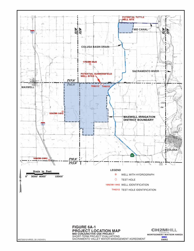
SummaryMaxwell Irrigation District is proposing a conjunctive water management project. Theproject would involve construction and operation of up to three new deep water wells for(1) reduction in surface water diversions, (2) improved reliability and availability of good-quality water to the District; (3) supplemental water for agriculturally induced wetlands;and (4) supply for Colusa Sub-basin lands during times of critical need. Each well would belocated adjacent to or in close proximity of the District’s existing conveyance canals. Shortlengths (less than 100 feet) of 16-inch smooth-wall pipe would be used, as needed, to conveywater from the wells to the existing canals. The water could then flow by gravity into theDistrict’s distribution system. This evaluation describes a short-term project that wouldyield approximately 8,000 acre-feet (ac-ft) of groundwater from the new wells during theirrigation season. It is assumed that an additional yield of approximately 5,000 ac-ft could bedeveloped to meet the wetland needs within the District and/or the adjacent DelevanNational Wildlife Refuge (NWR) in the fall of drier years. The project location and well sitesare illustrated on Figure 6A-1.
The District is located approximately 10 miles north of the City of Williams and approxi-mately 15 miles south of the City of Willows. The District boundaries are the Colusa Drainon the east, Maxwell Road on the north, and Two Mile Road on the west (Figure 6A-1). Thesouthern boundary is irregular and locally extends to Lurline Road. Glenn-Colusa IDsurrounds the District on the north, west, and south. A portion of the District’s northernboundary is shared with Delevan NWR. Sharing property boundaries with Delevan NWRgives the District opportunities to assist in providing environmental benefits. For instance,within the District, approximately 4,600 acres are planted with rice each year, and 1,500acres are permanent wetlands. This represents almost 90 percent of the entire District, whichprovides obvious and direct environmental benefit to the waterfowl migration in thePacific Flyway.
The majority of the District overlies the Stony Creek aquifer, which has excellent rechargecharacteristics. The District has already undertaken reconnaissance-level subsurface explor-ation to better understand and evaluate its ability to make use of this aquifer. Such investi-gations should be coordinated with other similar projects within the sub-basin so as toascertain a comprehensive understanding of system dynamics and determine possibleassociated impacts to the basin with regard to future groundwater development.Groundwater development of the Stony Creek aquifer is being considered by severaldistricts within the Colusa Sub-basin, including but not limited to Glenn-Colusa ID, Orland-Artois Water District, and Orland Unit.
Short-term ComponentThe proposed conjunctive use project would include the development of up to three deepwells (approximately 900 feet below ground surface (ft-bgs) that would pump approxi-mately 5,000 to 6,000 gallons per minute (gpm) each and would be located in close proxi-mity to the District’s existing conveyance canals. Each well would be constructed of 20-inchand 16-inch blank and 16-inch perforated casing. The perforated casing would consist oflouvered well screen. Use of louvered well screens would minimize the risk of beingdamaged during construction and well development. It would also allow for future re-development of the well using aggressive surging and bailing techniques. Each well would

PROJECT 6AMAXWELL IRRIGATION DISTRICT
CONJUNCTIVE USE PROJECT
RDD\ 012970048 ($ASQRDD1902658) 6A-3
be grouted and sealed to a depth of 270 ft-bgs to minimize the risk from infiltration ofsurface water into the subsurface.
Initially, the wells would be used primarily as a supplemental or back-up supply to theDistrict’s existing surface water supplies from the Sacramento River and its tributaries whensurface water supplies are curtailed. The project would improve the availability of a reliablesupply of good-quality water for the District’s 6,100 acres of permanent and agriculturallyinduced wetlands, reducing dependence on surface water diversions for this use. Inaddition, having groundwater wells available would provide the opportunity to supply8,000 to 13,000 ac-ft of groundwater to lands within the Colusa Sub-basin during times ofcritical need.
The District has an agreement with a landowner to develop up to two wells located alongthe District’s main east/west canal leading from the Sacramento River to the Colusa Drain(potential Tuttle well sites) in Section 9, Township 16 North and Range 2 West(Figure 6A-1).
Two additional potential well sites have been identified along the northern boundary of theDistrict’s main service area adjacent to Maxwell Road (potential Gunnersfield well sites).The Gunnersfield sites are adjacent to the District’s main delivery canal in Section 5,Township 16 North and Range 2 East. Test Holes 6312 and 6313 were drilled and logged atthese locations in 1993 to depths of 750 and 770 ft-bgs, respectively. Luhdorff & Scalmanini,Consulting Engineers conducted an evaluation of the sites and prepared a report for theDistrict (dated March 1995). The report indicates that adequate, reliable supply is availableto the District from the Stony Creek Aquifer. Use of these sites would be dependent upontheir acquisition from the landowner.
The District is in an ideal location to take advantage of available groundwater supplies toenhance conjunctive use and provide water for environmental benefits. These benefits couldcome as reduced diversions from the Sacramento River and/or increased supplies toDelevan NWR and improved water quality in the Colusa Drain. This project would providethe opportunity to realize these environmental benefits.
MonitoringQuestions that need to be addressed with regard to the impacts of implementingconjunctive use operations in close proximity to the Sacramento River and tributary streamsinclude, but are not limited to:
1. Would pumping intercept surface water from the river by directly inducing infiltrationin response to nearby groundwater pumping?
2. Would induced recharge occur, and if so, how, where, and when (e.g., purposefulartificial recharge vs. in-lieu recharge)?
3. How would the basin be managed within its perennial yield?
4. Would third-party impacts (e.g., groundwater-level impacts) result from operationsduring pumping cycles?

PROJECT 6AMAXWELL IRRIGATION DISTRICTCONJUNCTIVE USE PROJECT
6A-4 RDD\ 012970048 ($ASQRDD1902658)
Once construction is complete, the District would implement a program to collect, evaluate,and report data regarding water use, water quality, and the groundwater/surface waterinteraction of the project. The District intends to develop its monitoring program in conjunc-tion with its groundwater management plan. Detailed parameters of the monitoringprogram would be developed during program design and initial program administration.This is likely to occur concurrent with well design and construction.
The District plans to include the Colusa High School Environmental Science Academy(Academy) as an integral component of the program. The District would provide technicalassistance, training, and funding to the Academy to assure the continuation of a qualityprogram. The reason for involving the Academy is to provide the participants with avaluable hands-on educational program relating to both local and statewide conservationand environmental issues, while at the same time collecting the necessary data for evalua-tion by the District or its engineer of project impacts on groundwater levels, quality, andriver/ aquifer interaction.
The monitoring and reporting program could include the following data collection:
� Collecting static groundwater-level data each spring and fall (initially this could be morefrequently obtained).
� Collecting monthly electrical conductivity (EC) and temperature data from each well.
� Collecting monthly EC and temperature data in the canal upstream and downstream ofeach well when the wells are in use.
� Groundwater sampling at least once each year when the wells are in use (possibly morefrequently during initial stages of the project).
� Performing annual reconnaissance surveys to identify and evaluate any potentialimpacts, either positive or negative, resulting from the project. Should negative impactsbe discovered, the District would take steps to evaluate the extent of the impacts anddetermine how best to remedy or mitigate them. Preparing quarterly reports thatsummarize data collected and comparing them with historical data. The reports mightinclude maps, photographs, charts, or other reasonable means to clearly depict the data.
Long-term ComponentThere is no direct long-term component associated with this project. The results of thisproject could lead to further development of regional groundwater resources.
Hydrogeologic Evaluation
Hydrogeologic SettingThe easterly portion of Colusa County, in which the District is located, is part of theSacramento Basin, an extensive groundwater body. The principal geologic formations in theproject area consist of continental Tehama Formation sediments at depth overlain byQuaternary alluvium and flood basin deposits. Flood basin deposits consist chiefly of siltand clay deposited in low-lying areas adjacent to major streams during periods of highrunoff. Coarser-grained alluvial fan deposits, exposed to the west of the project, might

PROJECT 6AMAXWELL IRRIGATION DISTRICT
CONJUNCTIVE USE PROJECT
RDD\ 012970048 ($ASQRDD1902658) 6A-5
interfinger with these flood basin deposits in the project area. The Tehama Formationcontinental deposit, which outcrops in the hills west of the project, is chiefly a hetero-geneous mix of gravel, sand, silt, and clay, some cobbles and boulders, sandstone, breccia,and conglomerate. These deposits extend to the base of freshwater at a depth of about2,000 feet. The Quaternary flood basin deposits probably do not extend to more than 200 or250 feet below the surface within the District.
Groundwater within the upper 200 to 250 feet is generally unconfined. The flood basindeposits are saturated most of the year because they absorb water from rainfall and theoverflow of small creeks. Recharge to the underlying continental deposits occurs as directinfiltration of rainfall and surface water flows in their outcrop area west of the project andpossibly via discharge from adjacent alluvial fan deposits and other deep sources.
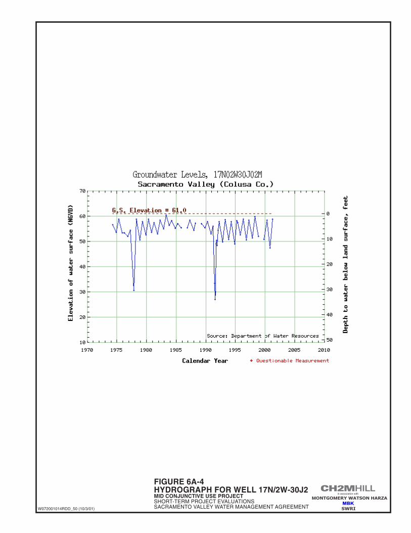
Available groundwater-level data in the general vicinity of the District (Figures 6A-2, 6A-3,and 6A-4) suggest that local pumping has caused minimal seasonal impacts and essentiallyno long-term impacts on groundwater levels and associated groundwater storage.Hydrographs of groundwater levels, plotted from the DWR online database, indicates thatseasonal fluctuations are generally on the order of less than 10 feet, and that there has beenno historical trend toward lowering groundwater levels that are not reflective of periodicregional drought conditions. Depth to groundwater in wells has generally been less than20 ft-bgs since about 1960. The locations of wells depicted on Figures 6A-2, 6A-3, and6A-4 hydrographs are shown on Figure 6A-1.
The sources of recharge identified above are of excellent quality for the purposes of irri-gation and wetland water supply. As indicated by historical observations from wells in thesurrounding area, the groundwater that would be pumped from these wells is also ofexcellent quality for the intended uses.
Hydrogeologic SuitabilityVarying amounts of groundwater were pumped for different purposes in the Town ofMaxwell area, mostly within the boundaries of the surrounding GCID during the years1992, 1994, 1995, 1996, and 1997. Throughout this time period, notably including the 1992and 1994 dry years when totals of 77,776 ac-ft and 52,152 ac-ft, respectively, were pumped,groundwater levels remained consistent with historical conditions (that is, minor seasonalfluctuations, but essentially no increasing or decreasing trend over time). Although themajority of this intermittent groundwater pumping occurred more to the north in GCID,some pumping at very high capacities also occurred in the Maxwell area. A review of thehistorical records indicates the pumping in this area has not caused a significant change ingroundwater levels or quality. Thus, even without purposeful artificial recharge, there iswidespread historical evidence that in-lieu recharge, particularly during periods of low tono pumping, has maintained an essentially constant or ”full” groundwater basin. This is abold statement…this is based on information from a couple of dry years separated by a wetyear and not a long-term drought condition. From these historical observations, it isassumed that MID’s proposed conjunctive use program of pumping and in-lieu recharge isboth technically feasible and unlikely to result in any substantial change in groundwaterconditions over those that have been experienced historically.

PROJECT 6AMAXWELL IRRIGATION DISTRICTCONJUNCTIVE USE PROJECT
6A-6 RDD\ 012970048 ($ASQRDD1902658)
Preliminary EvaluationsThe majority of wells in the vicinity of the planned District wells are constructed about 300to 400 ft-bgs; two wells are constructed to approximately 700 ft-bgs – a municipal well inMaxwell to the west of the District and an irrigation well about 2 ½ miles northwest of theDistrict. The District’s Gunnersfield test holes TH 6312 and TH 6313 were drilled and loggedto depths of 750 770 ft-bgs, respectively.
Thick aquifer materials exist between about 100 and 400 ft-bgs throughout the area east andnortheast of the District. These aquifer materials are highly transmissive and capable ofyielding significant volumes of groundwater to wells that develop from them. These samematerials thin significantly from east to west, and occur as relatively thin lenses at thelocations of the District’s test holes. For purposes of this summary, the aquifer materialsbetween 100 and 400 ft-bgs are called the shallow aquifer.
At both of the District’s Gunnersfield test hole sites, highly permeable aquifer materialswere encountered at depth of approximately 600 ft-bgs. Few wells are completed in thedeep aquifer near the planned District wells. The only deep wells with logs on file at DWRare the one municipal well at Maxwell, located about 5 miles west of the District’s test holesites, and one irrigation well, located about 2 ½ miles northwest of the District’s test holesites. For purposes of this summary, aquifer materials below a depth of about 400 ft-bgs arecalled the deep aquifer.
The distribution of the deep aquifer materials to the east and northeast is not known . Therehas been no groundwater exploration below about 400 ft-bgs. This is likely because wellscompleted to that depth have provided sufficient yields, and there has been no need to incurthe expense to explore for deeper aquifer materials.
Using the results of the Gunnersfield test hole evaluations for TH 6312 and TH 6313, preli-minary well designs have been prepared. Final well designs would be prepared upon thecompletion and evaluation of three new test holes that would be drilled to about1,000 ft-bgs. The preliminary design would include wells constructed to depths of about900 ft-bgs with multiple sections of well screen beginning at a depth of about 240 ft-bgs.Plans call for a 75-foot sanitary seal, 230 feet of annular seal, and 20-inch-diameter casingtransitioning to 16-inch-diameter casing with a slip joint at about 290 feet in. This preli-minary well design was used to obtain well construction costs. (The District is currentlyworking with a well driller to refine the well construction and equipping costs).
Preliminary Aquifer Response AnalysisEstimates of aquifer characteristics, derived from lithologic descriptions and shallow wellyields, indicate the transmissivity of the shallow aquifer is on the order of 150,000 gallonsper day per foot (gpd/ft) of aquifer width. The only available data on deep well yield fromthe Maxwell municipal well suggests that the transmissivity of the deep aquifer could be aslow as 12,000 to 15,000 gpd/ft. However, the nature of the deep aquifer materials at theDistrict’s test hole sites suggests that well yields should be closer to those of the shallowaquifer to the east-northeast, and not as low as to the west at Maxwell. Consequently, forpurposes of this summary, the transmissivity of the deep aquifer materials at the District’swell sites is estimated to be about 150,000 gpd/ft.

PROJECT 6AMAXWELL IRRIGATION DISTRICT
CONJUNCTIVE USE PROJECT
RDD\ 012970048 ($ASQRDD1902658) 6A-7
There are no data with which to estimate the storativity of the shallow or deep aquifermaterials in the Maxwell area. The lithology of the area suggests that the shallow materialsare likely to be semi-confined, and the deep materials are more likely confined. Forpurposes of this evaluation, aquifer storativity is assumed to be in the range of thoseconditions: 0.005 (semi-confined) to 0.0005 (confined).
As introduced above, the District’s planned wells would each be designed for pumpingcapacities up to 6,000 gpm; depending on aquifer characteristics and associated well yieldsin the area, it is desired that a minimum pumping capacity be 5,000 gpm per well. Since theDistrict plans to use the wells as a supplemental, or partial replacement, supply for aportion of its surface water deliveries from USBR, there are no defined water requirementsfor the wells in a conventional sense (i.e., the wells would discharge a planned annualvolume of water to irrigate a certain area). Rather, the wells would initially be used tosupplement or “replace,” as necessary, some of the District’s early season surface waterdiversions. The wells could be operated, during the irrigation season, as long as 60 daysduring April and May, or as long as 120 days from April through mid-August in any givenyear. In addition, the wells could be used to provide water in the fall of drier years for ricestraw decomposition and for wetland habitat both within the District and, if necessary,within Delevan NWR.
Distance drawdown and well interference computations were made using the theoreticalaquifer characteristics described above and a well field consisting of two wells spacedapproximately 1,500 feet apart. If each of the proposed wells located at the sites for TH 6312and TH 6313 were pumped at their design capacity of 6,000 gpm, the pumping water levelin each well would be about 134 ft-bgs after 120 days of pumping. Distance drawdowncalculations indicate that similarly constructed wells can be expected to experience about45 feet of interference drawdown at a radial distance of 1,000 feet, and about 20 feet of inter-ference drawdown 10,000 feet from the wells. However, once the future wells come online,an evaluation of the potential for groundwater/surface water interaction would be con-ducted. Furthermore, coordination with adjacent groundwater users would be needed toforecast the additional interference drawdown that would occur as a result of implementingcombined conjunctive use programs valleywide.
2. Potential Project Benefits/ BeneficiariesThis project would assure that a reliable supply of good-quality water would be available tosupport a diverse wetland community within the project area. Initially, this supply wouldbe used as a supplemental or back-up supply for the District’s surface water supplies.Therefore, the wells would be used, as needed, to assure a continuous supply to theDistrict’s 6,100 acres of permanent and agriculturally induced wetlands. In addition, thisproject would provide the opportunity to help meet the increasing water supply and waterquality demands of the District, Colusa Drain, Delevan NWR, Sacramento River, and Bay-Delta Estuary.
Local BenefitsLocal benefits of this project include a reliable supply of good-quality water to meet both theagricultural and wetland needs within the District, especially in times of shortages. In

PROJECT 6AMAXWELL IRRIGATION DISTRICTCONJUNCTIVE USE PROJECT
6A-8 RDD\ 012970048 ($ASQRDD1902658)
addition, the conjunctive use of water developed under this project would provide morereliable supplies for water users who rely on the water supply available in the Colusa Drain.This also could result in improved water quality in the Colusa Drain. The project could beexpanded in the future to provide water to the Delevan NWR while maintaining the supplyto meet the District’s needs.
Added Delta SupplyIn times of shortages in the Delta, the District could rely on the groundwater supplydeveloped under this project and forego some of its surface water supply. This remainingsurface water supply could then be made available to help meet Delta outflow and waterquality requirements as well as other Delta demands.
Water Quality ImprovementThis project would provide a supplemental supply of good-quality water, which could beused to maintain and improve water quality within the District as well as the Colusa Drain.This alone would benefit over 50,000 acres. In addition, this water supply could be used, ifnecessary, to improve water quality conditions within Delevan NWR. Water not diverted bythe District from the Sacramento River could be made available to meet water qualityrequirements downstream of the District’s point of a diversion and in the Delta.
3. Project CostsThe cost opinions shown, and any resulting conclusions on project financial or economicfeasibility or funding requirements, have been prepared for guidance in project evaluationfrom the information available at the time of the estimate. It is normally expected that costopinions of this type, an order-of-magnitude cost opinion, would be accurate within +50 to-30 percent. Project costs were developed at a conceptual level only, using data such as costcurves and comparisons with bid tabs and vendor quotes for similar projects. The costswere not based on detailed engineering design, site investigations, and other supportinginformation that would be required during subsequent evaluation efforts.
The final costs of the project and resulting feasibility will depend on actual labor andmaterial costs, competitive market conditions, actual site conditions, final project scope,implementation schedule, continuity of personnel and engineering, and other variablefactors. As a result, the final project costs will vary from the opinions presented here.Because of these factors, project feasibility, benefit/cost ratios, risks, and funding needsmust be carefully reviewed prior to making specific financial decisions or establishingproject budgets to help ensure proper project evaluation and adequate funding.
The capital costs for developing this program are estimated to be approximately $1,287,000as shown in Table 6A-1. The District’s Board of Directors has authorized the cost share at alevel of up to $75,000. The District’s share of the capital costs would be paid from its existingreserves. Future costs for operation of the project, maintenance of project facilities, andmonitoring and reporting would be paid by the District through its standby water avail-ability charges and water tolls. These future costs include the administration and moni-toring of the conjunctive use plan that is estimated to cost approximately $5,000 per year. Inaddition to the $75,000 cost share and annual O&M and monitoring costs, the District has
PROJECT 6AMAXWELL IRRIGATION DISTRICT
CONJUNCTIVE USE PROJECT
RDD\ 012970048 ($ASQRDD1902658) 6A-9
paid $20,000 towards securing the proposed Tuttle well site locations as well as approxi-mately $25,000 for the two Gunnersfield test wells and 1995 report. In addition, the Districtexpended approximately $650,000 to construct an inverted siphon under the Colusa BasinDrain to convey water from its Sacramento River pumping plant to the District’s main canal.Prior to completion of this project, water diverted from the Sacramento River was deliveredinto the Colusa Basin Drain at the Maxwell Dam near the northeast boundary of DelevanNWR. This water was then re-diverted from the Colusa Drain, into the District’s main canal,and on to the District’s service area. The siphon project allows the District to deliver high-quality Sacramento River water directly to its place of use without mixing it with waterfrom the Colusa Basin Drain. Groundwater pumped at the Tuttle sites would also beconveyed through the siphon to the remainder of the District’s service area. While notconstructed expressly for the purpose of conveying groundwater, the siphon project is animportant element in the District’s planned conjunctive use program.
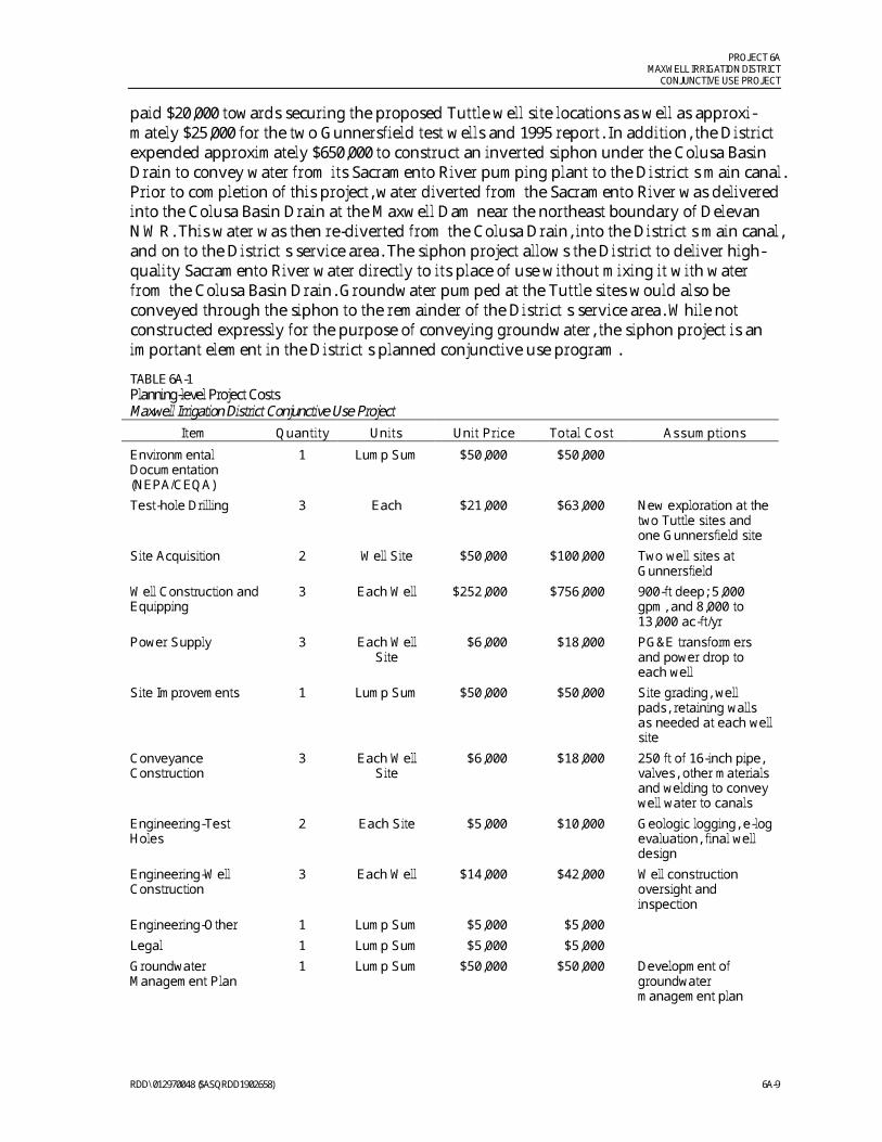
TABLE 6A-1Planning-level Project CostsMaxwell Irrigation District Conjunctive Use Project
Item Quantity Units Unit Price Total Cost Assumptions
EnvironmentalDocumentation(NEPA/CEQA)
1 Lump Sum $50,000 $50,000
Test-hole Drilling 3 Each $21,000 $63,000 New exploration at thetwo Tuttle sites andone Gunnersfield site
Site Acquisition 2 Well Site $50,000 $100,000 Two well sites atGunnersfield
Well Construction andEquipping
3 Each Well $252,000 $756,000 900-ft deep; 5,000gpm, and 8,000 to13,000 ac-ft/yr
Power Supply 3 Each WellSite
$6,000 $18,000 PG&E transformersand power drop toeach well
Site Improvements 1 Lump Sum $50,000 $50,000 Site grading, wellpads, retaining wallsas needed at each wellsite
ConveyanceConstruction
3 Each WellSite
$6,000 $18,000 250 ft of 16-inch pipe,valves, other materialsand welding to conveywell water to canals
Engineering-TestHoles
2 Each Site $5,000 $10,000 Geologic logging, e-logevaluation, final welldesign
Engineering-WellConstruction
3 Each Well $14,000 $42,000 Well constructionoversight andinspection
Engineering-Other 1 Lump Sum $5,000 $5,000
Legal 1 Lump Sum $5,000 $5,000
GroundwaterManagement Plan
1 Lump Sum $50,000 $50,000 Development ofgroundwatermanagement plan

PROJECT 6AMAXWELL IRRIGATION DISTRICTCONJUNCTIVE USE PROJECT
6A-10 RDD\ 012970048 ($ASQRDD1902658)
TABLE 6A-1Planning-level Project CostsMaxwell Irrigation District Conjunctive Use Project
Item Quantity Units Unit Price Total Cost Assumptions
Administration 1 Lump Sum $20,000 $20,000 Administer conjunctiveuse programdevelopment
Subtotal $1,187,000
Contingencies and Allowances (30% ) $356,100
Total Construction Costs $1,543,100
Environmental Mitigation (5%) $77,200
Engineering, Construction Management and Admin. (25%) $385,800
Total Initial Project Cost $2,006,100
NEPA/CEQA = National Environmental Policy Act/California Environmental Quality ActPG&E = Pacific Gas and Electric
4. Environmental IssuesThe project area is located in Colusa County between the Town of Maxwell on the west andthe Sacramento River on the east. As identified in a biological survey report prepared for theDistrict in 1997, the topography of the project area is typical of the Great Central Valley ofCalifornia, consisting primarily of flat and slightly undulating terrain with a 0 to 2 percentslope.
As noted in Section 2, this project is anticipated to provide benefits in the form of increasedwater supply, more flexible water management, and improved water quality – all of whichcould improve the greater Sacramento River ecosystem.
Project implementation would also result in impacts to the environment, notably throughthe artificial manipulation of groundwater levels. In some areas of the state, these types ofprojects have resulted in public concern and controversy, which tends to heighten scrutinyof the environmental effects of such projects. Efforts to address these concerns are noted inSection 5, Implementation Challenges. Construction-related impacts would also occur priorto project implementation. Construction-related impacts would be similar to other, commonconstruction projects that occur near seasonal drainages and waterways. It is likely that theappropriate level of environmental documentation necessary for this project would be anenvironmental impact statement/environmental impact report (EIS/EIR).
Implementation of the project would also require issuance of permits from variousregulatory agencies. Following is a summary of the likely permitting requirements.Additional permitting requirements may be identified pending further project refinement.
� State Water Resources Control Board—Applications for new water rights and changesin point of diversion would be required.
� Regional Water Quality Control Board—Large amounts of earthwork would berequired for the recharge basins. Depending upon project configuration and location,Water Quality Certification under the federal Clean Water Act may be required forconstruction.
PROJECT 6AMAXWELL IRRIGATION DISTRICT
CONJUNCTIVE USE PROJECT
RDD\ 012970048 ($ASQRDD1902658) 6A-11
� Federal and State Endangered Species Act—Consultation with state and federalresource agencies (e.g., USFWS, NMFS, CDFG) may be required to protect special-statusspecies and their habitat.
� U.S. Army Corps of Engineers—The project may affect wetland habitat and require apermit for discharge of dredged or fill material pursuant to Section 404 of the federalClean Water Act.
� State Lands Commission—The project would need to consult with State LandsCommission on the public agency lease/encroachment permitting for use of state lands.
� State Reclamation Board—The project may be subject to rules regarding encroachmentinto existing floodways.
� Federal Emergency Management Agency (FEMA)—Letters of map revision need to befiled with FEMA for projects that affect Flood Insurance Rate Maps.
� Advisory Council on Historic Preservation—Consultation under Section 106 of theNational Historic Preservation Act may be necessary if historical resources are affectedby construction of the project.
� California Department of Fish and Game—If alterations to streams or lakes arerequired as part of project implementation, a Streambed or Lakebed AlterationAgreement may be required.
� Local governments and special districts—Specific agreements for rights-of-way,encroachments, use permits, or other arrangements may need to be made with localentities in the vicinity of the project.
A draft CEQA environmental checklist has been prepared for this proposed project and isincluded as an attachment to this evaluation. The checklist provides a preliminary assess-ment of the environmental areas of concern, as well as areas that are not likely to be ofconcern, associated with this project. The checklist would be finalized as part of theenvironmental compliance required for project implementation.
5. Implementation ChallengesThe project implementation would occur in several incremental stages, each of which wouldhave significant challenges. Many of these challenges would be inherent to any project ofthis size and complexity. The following lists some of the implementation challengesanticipated to be associated with this project.
Public PerceptionLandowners have significant concern regarding possible groundwater overdraft. While theaquifer recharge aspects of this project may go a long way to alleviate these concerns,overdraft likely would remain a concern throughout the various stages of this project fromfeasibility analysis through construction and very likely continue thereafter. Monitoring andmodeling of groundwater levels would not only be an essential part of this project techni-cally, but also politically. Further, public concern accompanies any water delivery project

PROJECT 6AMAXWELL IRRIGATION DISTRICTCONJUNCTIVE USE PROJECT
6A-12 RDD\ 012970048 ($ASQRDD1902658)
during these water-tight times with regard to whom any project may or, just as importantly,may not benefit. As a result, many counties have passed ordinances and set numerousgroundwater management objectives. To that end, the county has set strict guidelines forsuch water management programs as water transfers that dictate the priority of transferstaking into consideration primarily the intended recipient of the water.
Coordination among Public and Private EntitiesStrong coordination would be required among local, state, and federal entities such asUSFWS, USBR, and DWR. The governmental agencies would have strong interestsassociated directly with the project and indirectly as it may affect other interests in the area.It is highly probable that because of the complexity and far-reaching implications of theproject that competing interest may arise. Reliable communication and integratedcoordination would be required to create a successful project.
Coordination between Concurrent ProjectsNumerous parties are examining similar projects throughout the valley. To optimize theeffectiveness of these projects, coordination between the endeavors would be required fromthe onset. The strongest motivation for such an effort is three-fold: (1) to avoid duplicationof effort and as a result efficiently utilize available funds, (2) to avoid the nullification ofproject benefits through competing projects, and perhaps most importantly, (3) to optimizethe benefits of these projects to the watershed.
Lack of Sufficient Groundwater DataIn many areas, there is limited groundwater information available, or the information that isavailable is unreliable.
Water Rights ImplicationsMaxwell ID’s water rights would have to be guaranteed and preserved. There is concernthat a “use it or lose it” mentality may become prevalent during the implementation of theconjunctive use program. Although the District would be expecting to decrease their annualsurface water diversions, it should not be assumed that they would be relinquishing acomparable amount to their water rights.
Environmental Regulatory ComplianceExtensive environmental documentation, surveying, monitoring, and permitting would berequired for this project. Habitat for known Endangered Species Act-listed species such asthe valley elderberry longhorn beetle and the giant garter snake is present within the projectarea. Project scheduling would have to reflect environmental regulatory requirementsincluding any limitation on windows of construction.
Land AcquisitionIt is probable that land would have to be acquired for the production wells, recharge basins,and conveyance systems. Some landowners may be resistant to the land purchases.

PROJECT 6AMAXWELL IRRIGATION DISTRICT
CONJUNCTIVE USE PROJECT
RDD\ 012970048 ($ASQRDD1902658) 6A-13
Recharge BasinsSiting of the recharge basins could be politically and environmentally challenging. The basinsiting would have to rely heavily on groundwater modeling results, public outreach, andclose coordination with environmental interest groups and government agencies(e.g., USFWS).
6. Implementation PlanAs shown graphically on Figure 6A-5, upon approval of the project and subsequent fundingagreements, the District would begin the preparation of the required environmental docu-mentation for the project. This process is expected to take up to 2 months to complete. Oncethe environmental documentation is complete, the District would drill two new test holesfor evaluation of the Tuttle well sites. The District would review the data from these testholes and compare them with the results of the two Gunnersfield test holes to determinewhich three of the four potential well sites would provide the greatest benefit for the project.Coincident with the drilling of the Tuttle test wells, the District would begin negotiationsregarding the acquisition of the Gunnersfield site or sites. It is estimated that the selection ofthe well sites would be completed within approximately 1 month of the completion of theenvironmental documentation.
After the three well sites have been selected, contracts would be let for the required siteimprovements including drilling and completion of the wells and conveyances, and PG&Ewould be contacted for the installation of the necessary equipment for the power supply ateach site. It is estimated the wells would be constructed, and all necessary tests would becompleted within 7 ½ months after the funding agreements have been signed.
������������������ �� ���
����������� ������ ��� ��������� ���������������� �������������������������������������������������������������� ������� ������� ����
!"�#$$%&!#'!%"�(!')
�
�
��
����������
��������������� ����
���������
�����������*�������
����������������*�������
������
������
������
� ���
����������
����������
������� ��
������ ������
� �����������������������������
� ����������������������
�������
� ����!��������
������� ������

������������������ + ���
����������"�� ������ ���������������������� ���������������� �������������������������������������������������������������� ������� ������� ����
!"�#$$%&!#'!%"�(!')

������������������ + ���
����������"�� ������ ���������������������� ���������������� �������������������������������������������������������������� ������� ������� ����
!"�#$$%&!#'!%"�(!')
������������������ + ���
����������"�� ������ �������������� ������� ���������������� �������������������������������������������������������������� ������� ������� ����
!"�#$$%&!#'!%"�(!')

������������������ �� ���
������������������"������������ ��������������� ���������������� �������������������������������������������������������������� ������� ������� ����
!"�#$$%&!#'!%"�(!')
�#$%&#$��'()#*'+$',&-��*./+$',&,)*'�#)--��/,,-$��$0,��*-$0
�(&-/&,$�&'1��$-$.,��$0,��*-$0�),$��+%#*($+$',0�#)--)'2�&'1��*+%-$,)*'�*3��$--0�'0,&--&,)*'�*3��)'*#��*'($4&'.$0�*'1/.,��$.$00��$0,0*'��*+%-$,$1��$--0
�$2*,)&,$��&'1�.5/)0),)*'*3��/''$#03)$-1��),$607�$($-*%��*'),*#)'2�&'1�$%*#,)'2��#*2#&+�#$%&#$�&'1��/8+),��#*9$.,�#*2#$00��$%*#,0
��:� � � + � , � -
�*',;

Project 6A—Draft CEQAEnvironmental Checklist

RDD\ 012970048-1 ($ASQRDD1902658)
Project 6A—Environmental Factors Potentially Affected:The environmental factors checked below would be potentially affected by this project, involvingat least one impact that is a “Potentially Significant Impact” as indicated by the checklist on thefollowing pages.
Aesthetics Agriculture Resources Air Quality
Biological Resources Cultural Resources Geology/Soils
Hazards & Hazardous Materials Hydrology/Water Quality Land Use/Planning
Mineral Resources Noise Population/Housing
Public Services Recreation Transportation/Traffic
Utilities/Service Systems Mandatory Findings of Significance
Determination:(To be completed by the Lead Agency)
On the basis of this initial evaluation:
I find that the proposed project COULD NOT have a significant effect on the environment, and aNEGATIVE DECLARATION will be prepared.
I find that although the proposed project could have a significant effect on the environment, therewill not be a significant effect in this case because revisions in the project have been made by oragreed to by the project proponent. A MITIGATED NEGATIVE DECLARATION will be prepared.
I find that the proposed project MAY have a significant effect on the environment, and anENVIRONMENTAL IMPACT REPORT is required.
I find that the proposed project MAY have a “potentially significant impact” or “potentiallysignificant unless mitigated” impact on the environment, but at least one effect 1) has beenadequately analyzed in an earlier document pursuant to applicable legal standards, and 2) hasbeen addressed by mitigation measures based on the earlier analysis as described on attachedsheets. An ENVIRONMENTAL IMPACT REPORT is required, but it must analyze only the effectsthat remain to be addressed.
I find that although the proposed project could have a significant effect on the environment,because all potentially significant effects (a) have been analyzed adequately in an earlier EIR orNEGATIVE DECLARATION pursuant to applicable standards, and (b) have been avoided ormitigated pursuant to that earlier EIR or NEGATIVE DECLARATION, including revisions ormitigation measures that are imposed upon the proposed project, nothing further is required.
Signature Date
Printed Name For

RDD\ 012970048-2 ($ASQRDD1902658)
Issues:
PotentiallySignificant
Impact
Less ThanSignificant
With MitigationIncorporation
Less ThanSignificant
ImpactNo
Impact
I. AESTHETICS—Would the project:
a) Have a substantial adverse effect on a scenic vista?
b) Substantially damage scenic resources, including,but not limited to, trees, rock outcroppings, and historicbuildings within a state scenic highway?
c) Substantially degrade the existing visual character orquality of the site and its surroundings?
Short-term impacts from increased noise and dustemissions could occur as a result of construction.Mitigation measures implemented for noise and airquality would reduce any impacts to a less thansignificant level.
d) Create a new source of substantial light or glare, whichwould adversely affect day or nighttime views in thearea?
II. AGRICULTURE RESOURCES―Would the project:
a) Convert Prime Farmland, Unique Farmland, orFarmland of Statewide Importance (Farmland), as shownon the maps prepared pursuant to the Farmland Mappingand Monitoring Program of the California ResourcesAgency, to non-agricultural use?
b) Conflict with existing zoning for agricultural use, or aWilliamson Act contract?
c) Involve other changes in the existing environmentwhich, due to their location or nature, could result inconversion of Farmland, to non-agricultural use?
Ill. AIR QUALITY—Where available, the significancecriteria established by the applicable air quality manage-ment or air pollution control district may be relied upon tomake the following determinations. Would the project:
a) Conflict with or obstruct implementation of theapplicable air quality plan?
b) Violate any air quality standard or contribute substan-tially to an existing or projected air quality violation?
Increased air emissions could result from construction ofthe project. Implementation of best managementpractices (BMPs) during construction would reduce theamount of emissions, and reduce the impact to a lessthan significant level.
c) Result in a cumulatively considerable net increase ofany criteria pollutant for which the project region is non-attainment under an applicable federal or state ambientair quality standard (including releasing emissions whichexceed quantitative thresholds for ozone precursors).
d) Expose sensitive receptors to substantial pollutantconcentrations?
e) Create objectionable odors affecting a substantialnumber of people?

RDD\ 012970048-3 ($ASQRDD1902658)
Issues:
PotentiallySignificant
Impact
Less ThanSignificant
With MitigationIncorporation
Less ThanSignificant
ImpactNo
Impact
IV. BIOLOGICAL RESOURCES—Would the project:
a) Have a substantial adverse effect, either directly orthrough habitat modifications, on any species identifiedas a candidate, sensitive, or special-status species inlocal or regional plans, policies, or regulations, or by theCalifornia Department of Fish and Game or U.S. Fish andWildlife Service?
b) Have a substantial adverse effect on any riparianhabitat or other sensitive natural community identified inlocal or regional plans, policies, regulations or by theCalifornia Department of Fish and Game or US Fish andWildlife Service?
c) Have a substantial adverse effect on federallyprotected wetlands as defined by Section 404 of theClean Water Act, (including, but not limited to, marsh,vernal pool, coastal, etc.) through direct removal, filling,hydrological interruption, or other means?
d) Interfere substantially with the movement of any nativeresident or migratory fish or wildlife species or, impedethe use of native wildlife nursery sites?
e) Conflict with any local policies or ordinances protectingbiological resources, such as a tree preservation policy orordinance?
f) Conflict with the provisions of an adopted HabitatConservation Plan, Natural Community ConservationPlan, or other approved local, regional, or state habitatconservation plan?.
V. CULTURAL RESOURCES—Would the project:
a) Cause a substantial adverse change in thesignificance of a historical resource as defined in§15064.5?
A significant impact would occur if a cultural resourcewere to be disturbed by activities associated with projectdevelopment. In the event that an archaeologicalresource was discovered, appropriate measures wouldbe undertaken to minimize any impacts.
b) Cause a substantial adverse change in thesignificance of an archaeological resource pursuant to§15064.5?
See response to V (a) above.
c) Directly or indirectly destroy a unique paleontologicalresource or site or unique geologic feature?
See response to V (a) above.
d) Disturb any human remains, including those interredoutside of formal cemeteries?
See response to V (a) above.

RDD\ 012970048-4 ($ASQRDD1902658)
Issues:
PotentiallySignificant
Impact
Less ThanSignificant
With MitigationIncorporation
Less ThanSignificant
ImpactNo
Impact
VI. GEOLOGY AND SOILS—Would the project:
a) Expose people or structures to potential substantialadverse effects, including the risk of loss, injury, or deathinvolving:
i) Rupture of a known earthquake fault, as delineatedon the most recent Alquist-Priolo Earthquake FaultZoning Map issued by the State Geologist for thearea or based on other substantial evidence of aknown fault? Refer to Division of Mines and GeologySpecial Publication 42.
ii) Strong seismic ground shaking?
iii) Seismic-related ground failure, includingliquefaction?
iv) Landslides?
b) Result in substantial soil erosion or the loss of topsoil?
c) Be located on a geologic unit or soil that is unstable, orthat would become unstable as a result of the project,and potentially result in on- or off-site landslide, lateralspreading, subsidence, liquefaction, or collapse?
d) Be located on expansive soil, as defined inTable 18-1-B of the Uniform Building Code (1994),creating substantial risks to life or property?
e) Have soils incapable of adequately supporting the useof septic tanks or alternative waste water disposalsystems where sewers are not available for the disposalof waste water?
VII. HAZARDS AND HAZARDOUS MATERIALS—Would the project:
a) Create a significant hazard to the public or theenvironment through the routine transport, use, ordisposal of hazardous materials?
Construction equipment would require the use ofpotentially hazardous materials. The potential forsignificant hazardous material spill would be unlikelybecause of the limited amount of such materials thatwould be used onsite. If a spill or release of suchmaterials were to occur, it could potentially be significantunless BMPs were implemented.
b) Create a significant hazard to the public or theenvironment through reasonably foreseeable upset andaccident conditions involving the release of hazardousmaterials into the environment?
c) Emit hazardous emissions or handle hazardous oracutely hazardous materials, substances, or waste withinone-quarter mile of an existing or proposed school?
d) Be located on a site which is included on a list ofhazardous materials sites compiled pursuant toGovernment Code Section 65962.5 and, as a result,would it create a significant hazard to the public or theenvironment?

RDD\ 012970048-5 ($ASQRDD1902658)
Issues:
PotentiallySignificant
Impact
Less ThanSignificant
With MitigationIncorporation
Less ThanSignificant
ImpactNo
Impact
e) For a project located within an airport land use plan or,where such a plan has not been adopted, within twomiles of a public airport or public use airport, would theproject result in a safety hazard for people residing orworking in the project area?
f) For a project within the vicinity of a private airstrip,would the project result in a safety hazard for peopleresiding or working in the project area?
g) Impair implementation of or physically interfere with anadopted emergency response plan or emergencyevacuation plan.
h) Expose people or structures to a significant risk ofloss, injury, or death involving wildland fires, includingwhere wildlands are adjacent to urbanized areas orwhere residences are intermixed with wildlands?
VIll. HYDROLOGY AND WATER QUALITY—Would the project:
a) Violate any water quality standards or waste dischargerequirements?There is a potential for an increase of erosion andsedimentation from construction activity that wouldrequire the implementation of BMPs to reduce anyimpacts to waterways in and around the project area.
b) Substantially deplete groundwater supplies or interferesubstantially with groundwater recharge such that therewould be a net deficit in aquifer volume or a lowering ofthe local groundwater table level (e.g., the production rateof pre-existing nearby wells would drop to a level whichwould not support existing land uses or planned uses forwhich permits have been granted).
There are serious concerns about the long-term draw-down of the groundwater table and land subsidence,particularly in dry years. Model development would helpin determining the effects of increased groundwaterpumping. The impact that groundwater withdrawal wouldhave on existing groundwater supplies is as yetundetermined; however, it is potentially significantbecause of the complexity of the issue.
c) Substantially alter the existing drainage pattern of thesite or area, including through the alteration of the courseof a stream or river, in a manner which would result insubstantial erosion or siltation on- or off-site?
d) Substantially alter the existing drainage pattern of thesite or area, including through the alteration of the courseof a stream or river, or substantially increase the rate oramount of surface runoff in a manner which would resultin flooding on- or off-site?
e) Create or contribute runoff water which would exceedthe capacity of existing or planned stormwater drainagesystems or provide substantial additional sources ofpolluted runoff?
f) Otherwise substantially degrade water quality?

RDD\ 012970048-6 ($ASQRDD1902658)
Issues:
PotentiallySignificant
Impact
Less ThanSignificant
With MitigationIncorporation
Less ThanSignificant
ImpactNo
Impact
g) Place housing within a 100-year flood hazard area asmapped on a federal Flood Hazard Boundary or FloodInsurance Rate Map or other flood hazard delineationmap?
h) Place within a 100-year flood hazard area structureswhich would impede or redirect flood flows?
i) Expose people or structures to a significant risk of loss,injury, or death involving flooding, including flooding as aresult of the failure of a levee or dam?
j) Inundation by seiche, tsunami, or mudflow?
IX. LAND USE AND PLANNING—Would the project:
a) Physically divide an established community?
b) Conflict with any applicable land use plan, policy, orregulation of an agency with jurisdiction over the project(including, but not limited to the general plan, specificplan, local coastal program, or zoning ordinance) adoptedfor the purpose of avoiding or mitigating an environmentaleffect?
Short-term impacts from increased noise and dustemissions could occur as a result of construction.Mitigation measures implemented for noise and airquality would reduce any impacts to a less thansignificant level.
c) Conflict with any applicable habitat conservation planor natural community conservation plan?
X. MINERAL RESOURCES—Would the project:
a) Result in the loss of availability of a known mineralresource that would be of value to the region and theresidents of the state?
b) Result in the loss of availability of a locally-importantmineral resource recovery site delineated on a localgeneral plan, specific plan or other land use plan?
XI. NOISE—Would the project result in:
a) Exposure of persons to or generation of noise levels inexcess of standards established in the local general planor noise ordinance, or applicable standards of otheragencies.
Short-term noise levels are expected to increase for theduration of construction. These noise increases would betemporary, and mitigation measures would beimplemented to reduce any impact to a less thansignificant level.
b) Exposure of persons to or generation of excessivegroundborne vibration or groundborne noise levels.
c) A substantial permanent increase in ambient noiselevels in the project vicinity above levels existing withoutthe project?

RDD\ 012970048-7 ($ASQRDD1902658)
Issues:
PotentiallySignificant
Impact
Less ThanSignificant
With MitigationIncorporation
Less ThanSignificant
ImpactNo
Impact
d) A substantial temporary or periodic increase inambient noise levels in the project vicinity above levelsexisting without the project.
See response to XI (a) above.
e) For a project located within an airport land use plan or,where such a plan has not been adopted, within twomiles of a public airport or public use airport, would theproject expose people residing or working in the projectarea to excessive noise levels?
f) For a project within the vicinity of a private airstrip,would the project expose people residing or working inthe project area to excessive noise levels?
XII. POPULATION AND HOUSING—Would the project:
a) Induce substantial population growth in an area, eitherdirectly (for example, by proposing new homes andbusinesses) or indirectly (for example, through extensionof roads or other infrastructure).
b) Displace substantial numbers of existing housing,necessitating the construction of replacement housingelsewhere?
c) Displace substantial numbers of people, necessitatingthe construction of replacement housing elsewhere?
XIII. PUBLIC SERVICES―Would the project:
a) Would the project result in substantial adverse physicalimpacts associated with the provision of new or physicallyaltered governmental facilities, need for new or physicallyaltered governmental facilities, the construction of whichcould cause significant environmental impacts, in order tomaintain acceptable service ratios, response times orother performance objectives for any of the publicservices?
Fire protection?
Police protection?
Schools?
Parks?
Other public facilities?
XIV. RECREATION―Would the project:
a) Would the project increase the use of existingneighborhood and regional parks or other recreationalfacilities such that substantial physical deterioration of thefacility would occur or be accelerated?
b) Does the project include recreational facilities orrequire the construction or expansion of recreationalfacilities, which might have an adverse physical effect onthe environment?

RDD\ 012970048-8 ($ASQRDD1902658)
Issues:
PotentiallySignificant
Impact
Less ThanSignificant
With MitigationIncorporation
Less ThanSignificant
ImpactNo
Impact
XV. TRANSPORTATION/TRAFFIC—Would the project:
a) Cause an increase in traffic, which is substantial inrelation to the existing traffic load and capacity of thestreet system (i.e., result in a substantial increase ineither the number of vehicle trips, the volume to capacityratio on roads, or congestion at intersections)?
b) Exceed, either individually or cumulatively, a level ofservice standard established by the county congestionmanagement agency for designated roads or highways?
c) Result in a change in air traffic patterns, includingeither an increase in traffic levels or a change in locationthat results in substantial safety risks?
d) Substantially increase hazards due to a design feature(e.g., sharp curves or dangerous intersections) orincompatible uses (e.g., farm equipment)?
e) Result in inadequate emergency access?
f) Result in inadequate parking capacity?
g) Conflict with adopted policies, plans, or programssupporting alternative transportation (e.g., bus turnouts,bicycle racks)?
XVI. UTILITIES AND SERVICE SYSTEMS—Would the project:
a) Exceed wastewater treatment requirements of theapplicable Regional Water Quality Control Board?
b) Require or result in the construction of new water orwastewater treatment facilities or expansion of existingfacilities, the construction of which could cause significantenvironmental effects?
c) Require or result in the construction of new stormwater drainage facilities or expansion of existing facilities,the construction of which could cause significantenvironmental effects?
d) Have sufficient water supplies available to serve theproject from existing entitlements and resources, or arenew or expanded entitlements needed?
e) Result in a determination by the wastewater treatmentprovider, which serves or may serve the project that ithas adequate capacity to serve the project’s projecteddemand in addition to the provider’s existingcommitments?
f) Be served by a landfill with sufficient permitted capacityto accommodate the project’s solid waste disposal needs?
g) Comply with federal, state, and local statutes andregulations related to solid waste?

RDD\ 012970048-9 ($ASQRDD1902658)
Issues:
PotentiallySignificant
Impact
Less ThanSignificant
With MitigationIncorporation
Less ThanSignificant
ImpactNo
Impact
XVII. MANDATORY FINDINGS OF SIGNIFICANCE
a) Does the project have the potential to degrade thequality of the environment, substantially reduce thehabitat of a fish or wildlife species, cause a fish or wildlifepopulation to drop below self-sustaining levels, threatento eliminate a plant or animal community, reduce thenumber or restrict the range of a rare or endangeredplant or animal or eliminate important examples of themajor periods of California history or prehistory?
b) Does the project have impacts that are individuallylimited, but cumulatively considerable? (“Cumulativelyconsiderable” means that the incremental effects of aproject are considerable when viewed in connection withthe effects of past projects, the effects of other currentprojects, and the effects of probable future projects)?
c) Does the project have environmental effects, which willcause substantial adverse effects on human beings,either directly or indirectly?