project interim report -...
TRANSCRIPT

Page 1 of 12
Project Interim Report
Hydrological and ecological impact of mining in and around
Mahan River
Sponsor
South Eastern Coalfields Limited (SECL)
Bilaspur, Chhatisgarh-495006
CSIR-National Environmental Engineering Research Institute
Nehru Marg, Nagpur 440020
July 21, 2017

Page 2 of 12
1.0 Origin of the Proposal and Problem Definition:
South Eastern Coalfields Limited has several coal mines in the area of Mahan River Valley.
The coal mining activity leads to several interferences with surface and sub-surface water
resources such as removal of mine water, disposal/use of mine water, storage of
storm/rainwater into the abandon mines etc. Therefore it would be required to undertake a
study for assessment of surface and sub-surface water regime in the coal mine project areas.
The impact of the mining activity on the ground and surface water may reach beyond the
mine activity area. However, the scope of the present study is restricted to study of water
regime in the sub-watershed surrounding the working minesand proposed mines of SECL in
Mahan River Valley.
The report details the present status of the work wherein the data received from the SECL are
mentioned. Besides, the primary data collected during the field visit are also presented.
2.0 Objectives of the Study
Preparation of study area maps with details of mine locations and drainage pattern.
Assessment of hydrogeological characteristics of the study area to establish the depth
to water (DTW) table and ground water development potential and current status of
GW development.
Assessment of impact of dewatering of mines on the water levels of the surrounding
wells or other water bodies, particularly the effects during summer season.
Impact assessment of seepage on water levels of the surrounding wells.
Analysis of river flow data for past ten years at various gauge stations in the study
area.
Analysis of water quality data for past ten years at various monitoring stations in the
study area.
Remote sensing images analysis of river catchment area to delineate spatial-temporal
variation in past ten years.
Water quality modelling to assess the impact of significant pollution parameter in the
river (provided river hydrodynamics, river width, depth profile and velocity/flow is
available).
Study on the effect of pumping out of the water from mines in terms of the ground
water levels and any pollution causing to surface/subsurface water bodies w.r.t to
quality of water pumped out from mines.

Page 3 of 12
Comparison of hydro-chemical aspects and water quality parameters for mine-water,
surface well water and borewell water in the study area.
Estimating the water budget of the mine area including drought patterns, annual flows
in the rivers and streams, water quality, existing water wells etc, through available
records. The proposed water management planning to be delineated.
Environmental base line to be established with respect to current period.
3.0 Scope of the project:
The entire study will be restricted to sub-watershedof Mahan River valley
The study by CSIR-NEERI will be based on secondary data
Any primary data collected in addition to the available secondary data is not
included in the scope of the study and will be generated separately by SECL if
required.
4.0 Study area
The study area is covered in the Survey of India toposheet No 64 M/3 (scale 1:50,000).
The study area has total existing 7 active mines namely Mahan (OCM), Mahan-II (OCM),
Bhatgaon (UG), Mahamaya (UG), Kalyani (UG), Shiwani (UG) and Nawapara (UG)
mines. There is one discontinued mine name Dugga (OCM). There are four proposed
mines in the area namely Jagarnathpur (OCM), Madannagar (OCM), Budauli (UG),
Amba (UG). Figure 1. Show the study area with existing, proposed and discontinued
mines. A reconnaissance of the area was undertaken and accordingly, two
microwatershed were delineated with covered the mines. One microwatershed covering
the Mahan-II is spread over an area of 77 sq km (Figure 2) whereas the microwatershed
coveringBhatgaon Underground Mine is spread over 102Sq km (Figure 3).

Page 4 of 12
Figure 1: Study area
5.0 Project progress till date
The work order reference no SECL/GM/BHAT/NO (Envt)/2017/155 has been receipt on
March 31, 2017(Annexure-1 enclosed herewith). In view of this, CSIR-NEERI has initiated
the work which include following:
1. Meeting with SECL delegate on June 12, 2017 to discussion about methodology and
data required for the study.
2. It was discussed that the study area has 7 active mines and four proposed mines.
CSIR-NEERI has to study the impact of existing mines on ground and surface water
of Mahan River.
3. Data required for the study are listed as below:
Total mining cluster in the study area.
Mine wise dewatering/discharge monthly data
Piezometer seasonal data
River discharge, width, depth data for last 10 years
Water sampling station details , frequency of data

Page 5 of 12
Population of villages and dependence of villager on ground water
Latest wildlife conservation report and fishery data for ecological impact
assessment.
Bore-well locations in the study area
CMPDI water quality historical data (surface and ground water quality)
4. SECL has provided Topo sheet (1:50000) scale and Site Plan of the study area to
CSIR-NEERI
6.0 Action taken
1. CSIR-NEERI has provided template for collection of above mentioned data.
2. SECL has provided GIS data, Groundwater data (partially), Surface water data (not
provided till data) and Ecological data (not provided till data).
3. One the bases of data provided and preliminary analysis of data, site visit to SECL has
been done from July 15-17th
, 2017.
4. Based on data provided by SECL and site visit observations, interim report has been
prepared.
5. Reconnaissance visit was undertaken by CSIR-NEERI to the SECL mine areas. The
locations of the existing and proposed projects were visited. Based on the location of
the mines and the drainage pattern, study areas on the watershed principle were
delineated. Based on the delineated study area, sampling locations for groundwater
level monitoring and groundwater sampling were selected.

Page 6 of 12
6.1. GIS Data Analysis and Mapping
SECL has provided Toposheet, Siteplan and Village details in the study area. However,
Toposheet and Village maps do not cover all the mines. Hence further information is
requested from SECL. The toposheet, siteplan and village map are geo-referenced and
overlayed on study area.
Gaps in Groundwater Data
Toposheet no64 I/15, 64 M/7, and 64 M/4 are required to delineate watershed boundary.
Details of villages around all coal mines in the study area
6.2. Groundwater Data Analysis
CSIR-NEERI has provided data template to SECL on June 19, 2017 for hydrological analysis
of ground water in the study area. The data required for groundwater analysis is A. Survey of
India topo sheet no B. Metrological Parameters (Since last five years) C. Village Background
Data for groundwater budgeting / social impact study and D. Water requirement (per day) of
major water consuming industries in the study area.
In respond to this, SECL has provide B & C data for 54 villages namely jagannathpur,
dharampur , madannagar, manpur, chaura, pakni, bagda, koteya, bojha, jingadodar, silphili,
marhata, chatarpur,chandrapur, khadgawankala, palma, songara, markadand, duppi, karsi,
tukudand, ganeshpur, daldali, singhra, madidand, mayapur, kerta , kapsara, jarhi, durti,
dugga, dumariya, bhatgaon, baraudhi, banshipur, karondha , tulsi,
batara,sattipara,anrokha,chungari,lakshmipur,chikni,sirsi,bundiya,sudamanagar,shyampur,sin
gri,dawankara,kewara, parvatipur, paldha, ohanpur, sukhdeopur.
Based on the reconnaissance visit, the study area consists of two microwatershed for the
purpose of analysing the groundwater analysis. A network of observation wells has been set
up (Tables 1 and Tables 2). The observations wells are mostly the Indian Mark-II hand
pumps. Groundwater samples were collected for physico-chemical parameters and heavy
metal analysis and are being analysed.

Page 7 of 12
Figure 1: Microwatershed covering the existing Mahan II mine and proposed mines at
Jaganannath Pur and Madanpur

Page 8 of 12
Figure 2: Microwatershed covering the existing Bhatgaon, Mahan I Mines
Page 9 of 12
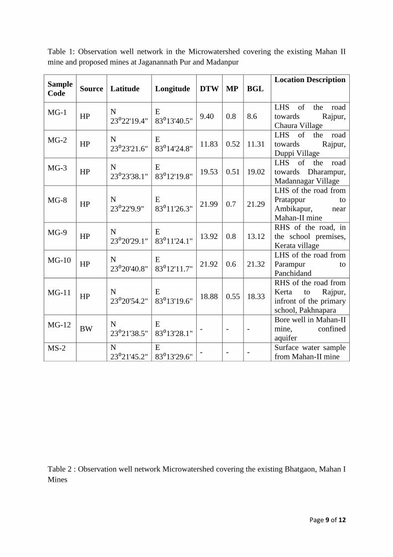
Table 1: Observation well network in the Microwatershed covering the existing Mahan II
mine and proposed mines at Jaganannath Pur and Madanpur
Table 2 : Observation well network Microwatershed covering the existing Bhatgaon, Mahan I
Mines
Sample
Code Source Latitude Longitude DTW MP BGL
Location Description
MG-1 HP
N
23⁰22'19.4"
E
83⁰13'40.5" 9.40 0.8 8.6
LHS of the road
towards Rajpur,
Chaura Village
MG-2 HP
N
23⁰23'21.6"
E
83⁰14'24.8" 11.83 0.52 11.31
LHS of the road
towards Rajpur,
Duppi Village
MG-3 HP
N
23⁰23'38.1"
E
83⁰12'19.8" 19.53 0.51 19.02
LHS of the road
towards Dharampur,
Madannagar Village
MG-8 HP
N
23⁰22'9.9"
E
83⁰11'26.3" 21.99 0.7 21.29
LHS of the road from
Pratappur to
Ambikapur, near
Mahan-II mine
MG-9 HP
N
23⁰20'29.1"
E
83⁰11'24.1" 13.92 0.8 13.12
RHS of the road, in
the school premises,
Kerata village
MG-10 HP
N
23⁰20'40.8"
E
83⁰12'11.7" 21.92 0.6 21.32
LHS of the road from
Parampur to
Panchidand
MG-11 HP
N
23⁰20'54.2"
E
83⁰13'19.6" 18.88 0.55 18.33
RHS of the road from
Kerta to Rajpur,
infront of the primary
school, Pakhnapara
MG-12 BW
N
23⁰21'38.5"
E
83⁰13'28.1" - - -
Bore well in Mahan-II
mine, confined
aquifer
MS-2
N
23⁰21'45.2"
E
83⁰13'29.6" - - -
Surface water sample
from Mahan-II mine

Page 10 of 12
The groundwater level measurement was done in the wells using the water level recorder
(Make:Solinst, Figure 3). The water level varied from 8.36m to 29.77m. The variation of
water level can be attributed to the withdrawal pattern in the study area as it is observed that
the area has significant no of borewells installed by the villager for meeting the drinking and
domestic requirements as well.
At present, the existing mines have dewatering schemes in place wherein the water is being
used for dousing the coal fire, use in dust suppression and supply to the colonies for meeting
the domestic requirements. It was observed that borewells (5 nos) have been installed in the
Mahan II (OCM). The water from these wells (Figure 4) is being used for dousing the coal
fire.
MG-4 HP
N
23⁰20'58.7"
E
82⁰59'51.2" 10.41 0.52 9.89
LHS of the road
towards market
from Bhatgaon
guest house
MG-5 HP
N
23⁰23'02.1"
E
82⁰59'59.1" 23.54 0.5 23.04
Centre of the
Adarshnagar
village, Dugga
(1.5 to 2 kms
from mine)
MG-6 HP
N
23⁰23'38.0" E 83⁰01'8.3" 8.80 0.44 8.36
RHS of the road,
Kapsara village
chowk
MG-7 HP
N
23⁰21'31.3"
E
83⁰03'09.3" 30.23 0.46 29.77
LHS of the road
from Jarhi to
Ambikapur,
Beside temple
MG-13 MW
N
23⁰20'59.1"
E
83⁰04'28.2" - - -
Mine water from
Shivani
underground
mine
MG-14 DW
N
23⁰22'41.4"
E
83⁰02'10.5" 1.50 0 1.50
Dug well in
Kapsara village
which is opposite
to Mahamaya
underground
mine
MS-1 SW
N
23⁰21'26.3"
E
83⁰05'15.0" - - -
Bank of the
Mahan River,
near bride

Page 11 of 12
The stage development of the study area is being attempted on the basis of primary data
collected in the field and the available secondary data provided by the SECL.
Figure 3: Water level measurement in Mark Hand Pump in the study area
Figure 4: Borewell in Mahan II

Page 12 of 12
Gaps in Groundwater data:
The following data are to be provided by SECL:
Dewatering data from all the working mines in the study area. The amount of dewatered
water and their usage pattern and disposal need to be provided.
6.3. Surface water data
CSIR-NEERI has provided data template to SECL on July 3, 2017 for hydrological analysis
of surface water in the study area. The data required for surface water quality includes: A.
Surface Water Quality 10 years data for Mahan River: details of sampling locations and
frequency of measurements for different parameters B. Parameter wise details of water
quality in Mahan River (DO & BOD), C. River width, depth, peak flow etc. D. Wastewater
Discharges in Mahan River E. Socio-economic data.
Gaps in surface water data
The none availability of river hydrodynamics and water quality data at various station in
river basin. SECL has not provided any data for surface water quality analysis. For surface
water quality analysis and hydrodynamicsmodelling , surface water quality data in required
A, B, C, D and E format are essential.
6.4. Ecological Data
For ecological impact assessment wildlife conservation report and fishery data are required.
But till date SECL has not provided the data.
Gaps in Ecological Data
1. Forest Management Plan (Singrauli) previous and recent one
2. Wildlife Management Plan for Elephants and wildlife census reports for last few decades
3. Crop depredation and human accidents due to man animal conflicts for last few decades
3. Fisheries yield over last one decade and related report from fisheries department
4. EIA reports available for respective mines falling in the study area
5. Forest Range Maps
7.0 Future action plan
The stage development of the Groundwater in the each delineated watershed will be
estimated.
Analysis of dewatering vis-à-vis the groundwater conditions in the surrounding wells